Engineering Dept. Highways & Transportation Engineering
|
|
|
- Olivia Burke
- 5 years ago
- Views:
Transcription

 Instructors:")
1 The University College of Applied Sciences UCAS Engineering Dept. Highways & Transportation Engineering (BENG 4326) Instructors: Dr. Y. R. Sarraj

2 Chapter 4 Traffic Engineering Studies Reference: Traffic & Highway Engineering N. J. Garber & L. A. Hoel pp
3 Course Objective One of this course objectives is to give: students the ability to: identify the existing traffic conditions by: conducting different surveys, based on: travel time, delays, speed, volume and capacity.
4 Traffic studies may be grouped into three main categories: (1) Inventories, (2) Administrative studies, and (3) Dynamic studies.
5 (1) Inventories: provide a list or graphic display of existing information, such as: street widths, parking spaces, transit routes, traffic regulations.
6 (2) Administrative studies use existing engineering records, available in government agencies and departments. include the results of surveys, which may involve: field measurements and/or aerial photography.
7 (3) Dynamic traffic studies involve the collection of data under operational conditions and include studies of: speed, traffic volume, travel time and delay, parking, and crashes. They are described in detail in this chapter.
8 4.1 SPOT SPEED STUDIES Spot speed studies are conducted to estimate the distribution of speeds of vehicles in a stream of traffic at a particular location on a highway. carried out by recording the speeds of a sample of vehicles at a specified location. Source: Garber, page 100
9 SPOT SPEED STUDIES Used to: Establish parameters for traffic operation and control, such as: speed zones, speed limits (85th-percentile speed)
10 4.1.1 Locations for Spot Speed Studies Should be selected to achieve the following: Unbiased data Drivers be unaware Equipment concealed from the driver, Observers inconspicuous.
11 4.1.2 Time of Day and Duration of Spot Speed Studies depends on the purpose of the study. recommended when traffic is free-flowing, during off-peak hours. typically: the duration is at least 1 hour and the sample size is at least 30 vehicles.
12 4.1.3 Sample Size for Spot Speed Studies The larger the sample size, will give an estimated mean within acceptable error limits. Average Speed Median Speed Modal Speed The ith-percentile Spot Speed Pace Standard Deviation of Speeds
13 4.1.4 Methods for Conducting Spot Speed Studies manual and automatic manual method is seldom used automatic devices 1. road detectors 2. radar-based 3. the principles of electronics.
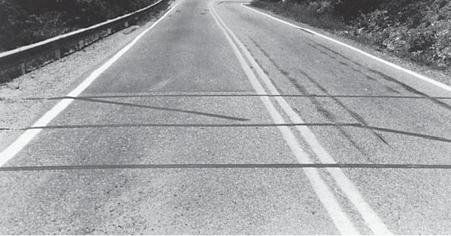
14 Manual Method By observing the time required by a vehicle to cover a short distance of roadway. (Direct-timing procedure) Requirements: Stop watch and a measuring tape. Start the stopwatch when the vehicle at point 1 and stop it when the vehicle at point 2. Point 1 Point 2
15 Manual Method The following table shows the recommended distance between points 1 and 2 for selected average speeds on the road. Average speed Recommended distance Estimated Time 40 km/h 45m 4 sec km/h 70m 4 sec. > 65 km/h 80m 4 sec. Point 1 Point 2
16
17 Road Detectors pneumatic road tubes & induction loops collect data on speeds & volume at the same time Advantage: Human errors are considerably reduced Disadvantages: expensive may, affect driver behavior,
18 Figure 4.9 Apollo Traffic Counter/Classifier
19 Pneumatic road tubes laid across the lane in which data are to be collected. When moving vehicle passes over, an air impulse is transmitted to the counter. two tubes are placed across the lane, 2 m apart. An impulse is recorded when the front wheels of a moving vehicle pass over the first tube;
20 Pneumatic road tubes a second impulse is recorded when the front wheels pass over the second tube. The time elapsed between the two impulses and the distance between the tubes are used to compute the speed of the vehicle.

21 inductive loop a rectangular wire loop buried under the roadway surface. It operates on the principle that a disturbance in the electrical field is created when a motor vehicle passes across it.
22 Radar-Based Traffic Sensors Electronic-Principle Detectors traffic characteristics, such as speed, volume, queues, and headways are computed. Using video camera Using video image processing
23 Median speed Modal speed i th -percentile speed Pace The speed at the middle value in a series of spot speeds. Or, 50 th -percentile speed The speed value that occurs most frequently in a sample of speeds The spot speed below which i percent of the vehicles travel, e.g. 85 th -percentile speed The range of speed that has the greatest number of observations; usually 10-mph range 85 % 50 %


24 (a) RTMS Deployed in the Forward Looking Mode


25 (b) RTMS Deployed in the Side-fire Mode


26 (a) Schematic Illustration of the Auto scope Autoscope video detection captures video images of traffic and analyzes the information using sophisticated algorithms for traffic management.


27 (b) The Auto scope Deployed
28 4.1.5 Presentation and Analysis of Spot Speed Data Statistical methods Analyzing data (speed limit, design speed) frequency histogram cumulative frequency distribution curve
29 Example 4.2 Determining Speed Characteristics from a Set of Speed Data. Table 4.2 shows the data collected on a rural highway in Virginia during a speed study. Develop the frequency histogram and the frequency distribution of the data and determine:
30 Table 4.2 Speed Data Obtained on a Rural Highway
31 1. The arithmetic mean speed 2. The standard deviation 3. The median speed 4. The pace 5. The mode or modal speed 6. The 85 th -percentile speed (speed limit) 7. The 95 th -percentile speed (design speed)
32 Solution: The speeds range from 34.8 to 65.0 km/h, giving a speed range of For eight classes, the range per class is 3.75 km/h; for 20 classes, the range per class is 1.51 km/h. It is convenient to choose a range of 2 km/h per class which will give 16 classes. A frequency distribution table can then be prepared, as shown in Table 4.3.

33 Table 4.2 Speed Data Obtained on a Rural Highway
34 Figure 4.4 Histogram of Observed Vehicles' Speeds

35 Table 4.3 Frequency Distribution Table for Set of Speed Data
36 Figure 4.5 Frequency Distribution
37 Figure 4.6 Cumulative Distribution
38 The median speed 49 km/h, the 50 th -percentile speed. 85 th -percentile speed is 54 km/h


39 4.2 Traffic VOLUME STUDIES Source: Garber, page 115
40 4.2 VOLUME STUDIES 1. Average Annual Daily Traffic (AADT) the average of 24-hour counts collected every day of the year. 2. Average Daily Traffic (ADT) the average of 24-hour counts collected over a number of days greater than one but less than a year.
41 4.2 VOLUME STUDIES 3. Peak Hour Volume (PHV) the maximum number of vehicles that pass a point on a highway during a period of 60 consecutive minutes. 4. Vehicle Classification (VC) with respect to the type of vehicles for cars, two-axle trucks, or three-axle trucks. 5. Vehicle Miles of Travel (VMT)
42 4.2.1 Methods of Conducting Volume Counts Manual Method Automatic Method

43 Figure 4.7 Jamar Traffic Data Collector TDC-1 2 Hooked to a Computer

44 Figure 4.9 Apollo Traffic Counter/Classifier


45 Figure 4.10 Example of Counters that Require the Laying of Subsurface Detectors


46 Figure 4.11 Traffic Eye Universal System

47 Figure 4.12 Example of Station Locations for a Cordon Count

48 4.2.2 Types of Volume Counts Depending on the anticipated use of the data to be collected. Intersection Counts vehicle classifications, through movements, turning movements.
49 4.2.2 Types of Volume Counts Pedestrian Volume Counts Periodic Volume Counts (AADT)
50 Traffic Volume Data Presentation
51 4.2.3 Traffic Volume Data Presentation Traffic Flow Maps: volume of traffic on each route is represented by the width of a band. Figure 4.13 shows a typical traffic flow map. Figure 4.13 Example of a Traffic Flow Map

52 Intersection Summary Sheets: Figure 4.14 shows a typical intersection summary sheet. Figure 4.14 Intersection Summary Sheet
53 4.2.3 Traffic Volume Data Presentation Time-Based Distribution Charts: see Figure 4.15
54 Daily variations: see Figure 4.15b Figure 4.15 Traffic Volumes on an Urban Highway (A&B)
55 Hourly variations in traffic volume: Figure 4.15 Traffic Volumes on an Urban Highway (C)
56 Summary Tables: PHV, Vehicle Classification (VC), and ADT. See Table 4.4 Table 4.4 Summary of Traffic Volume Data for a Highway Section
57 Peak Hour Factor (PHF) Peak Hour Factor = total flow in the peak hour PHF = V. 4x(v 15 ) max Time 4 (max flow per 15 minutes) vehicles 7:00 7: :15 7: :30 7: :45 8: Determine PHF
 Prak Hour Factor 520 8:00 7:45 600")

58 vehicles per 15 minutes Peak Hour Factor (PHF) Prak Hour Factor 520 8:00 7: :45 7:30 7:30 7:15 Time 500 7:15 7: Bar Chart

59 Vehicle Classification (VC) Pie Chart
60 Adjustment of Periodic Counts Source: Garber, page 130
61 Adjustment of Periodic Counts Expansion Factors from Continuous Count Stations. Source: Garber, page 130
62 Hourly expansion factors (HEFs) are determined by the formula 24-hr traffic flow traffic flow/hour * 24
63 Daily expansion factors (DEFs) are computed as
64 Monthly expansion factors (MEFs) are computed as
65 Table 4.5 Hourly Expansion Factors for a Rural Primary Road
66 Table 4.6 Daily Expansion Factors for a Rural Primary Road
67 Table 4.7 Monthly Expansion Factors for a Rural Primary Road
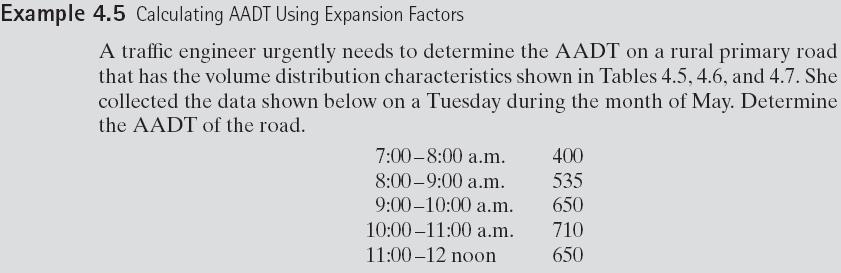
68
69 Collected data Veh/hr
70
71 4.3 TRAVEL TIME AND DELAY STUDIES Source: Garber, page 133
72 4.3 TRAVEL TIME AND DELAY STUDIES Travel time: time required to travel from one point to another on a given route. the locations, durations, and causes of delays. good indication of the level of service identifying problem locations,
73 4.3.1 Applications of Travel Time and Delay Data efficiency of a route locations with relatively high delays causes for delays before-and-after studies relative efficiency of a route travel times on specific links economic studies
74 4.3.2 Definition of Terms Related to Time and Delay Studies 1. Travel time: time taken by a vehicle to traverse a given section of a highway. 2. Running time: time a vehicle is actually in motion 3. Delay time lost due to causes beyond the control of the driver.
75 5. Travel-time delay: difference between the actual travel time and the travel time obtained by assuming that a vehicle traverses at an average speed equal to that for an uncongested traffic flow (speed limit).
76 Travel-time delay Travel-time delay = actual (total) travel time ideal time Where: Actual travel time = distance travelled average journey speed Ideal time = distance travelled speed limit Where: speed limit is the maximum allowable speed on the road.
77 Travel-time delay Examples
78 Example 1: On a road section; Travel time delay Distance travelled = 3000m Journey time = 5 minutes Speed limit = 50 km/h Find: Average journey speed Travel time delay.
79 Solution: Travel time delay On a road section; Distance travelled = 3000m Total journey time = 5 minutes Speed limit = 50 km/h Find: Average journey speed = distance/total time = 3000/(5*60) m/s = 10 m/s Ideal travel time = 3000/(50/3.6) sec. = 216 sec = 3.6 min Travel time delay = total journey time ideal travel time = = 1.4 min
80 Example 2: Travel time delay Example 2 Given that d = 5km 5000m Total travel time = 10 min 600 sec speed limit = 60km/hr 16.67mlsec Find travel time delay Solution: average journey speed = d/ total travel time 8.33 m/sec 30 km/hr ideal time = d/speed limit 300 sec 5 min delay = travel time - ideal time = 5 min
81 4.4 PARKING STUDIES Source: Garber, page 139
82 4.4 PARKING STUDIES Any vehicle will at one time be parked short time or longer time, provision of parking facilities is essential need for parking spaces is usually very great in areas of business, residential, or commercial activities. park-and-ride
83 Providing adequate parking space to meet the demand for parking in the Central Business District (CBD) This problem usually confronts a city traffic engineer. solution is not simple, Parking studies are used to determine the demand for and the supply of parking facilities.
84 4.4.1 Types of Parking Facilities On-Street Parking Facilities also known as curb facilities. Parking bays are provided alongside the curb on one or both sides of the street. unrestricted parking unlimited and free Restricted parking facilities


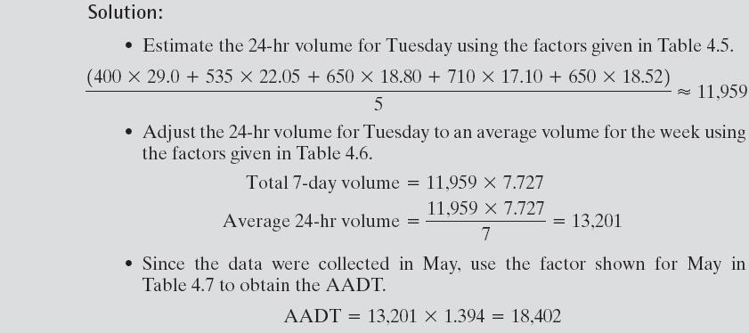
85 On street parking (curb parking) Angle Parking Parallel Parking
86 On-Street Parking Facilities limited to specific times for a maximum duration. may or may not be free. handicapped parking bus stops loading bays.
87 Off-Street Parking Facilities privately or publicly owned; surface lots and garages. Self-parking garages attendant-parking garages
88 Off-Street Parking
89 4.4.2 Definitions of Parking Terms 1. A space-hour is a unit of parking that defines the use of a single parking space for a period of 1 hour. 2. Parking volume is the total number of vehicles that park in a study area during a specific length of time, usually a day.
90 3. Parking accumulation is the number of parked vehicles in a study area at any specified time. 4. parking load the number of space-hours used during the specified period of time. 5. Parking duration length of time a vehicle is parked at a parking indication of how frequently a parking space becomes available.
91 6. Parking turnover rate of use of a parking space. is determined by dividing the parking volume for a specified period by the number of parking spaces. Parking turnover = parking volume parking spaces
92 Turnover and Duration: For example, if the maximum permissible duration of parking at a curb face is 1 hour, a suitable interval is every 20 minutes. If the permissible duration is 2 hours, checking every 30 minutes would be appropriate. Turnover is then obtained from the equation
Introduction. Traffic data collection. Introduction. Introduction. Traffic stream parameters
 Introduction Traffic data collection Transportation Systems Engineering Outline Point measurement Measurement over a short stretch Measurement over a long stretch Measurement over an area 20080813 Traffic
Chapter 12 VEHICLE SPOT SPEED STUDY
 Chapter 12 VEHICLE SPOT SPEED STUDY 12.1 PURPOSE (1) The Vehicle Spot Speed Study is designed to measure the speed characteristics at a specified location under the traffic and environmental conditions
LAWRENCE TRANSIT CENTER LOCATION ANALYSIS 9 TH STREET & ROCKLEDGE ROAD / 21 ST STREET & IOWA STREET LAWRENCE, KANSAS
 LAWRENCE TRANSIT CENTER LOCATION ANALYSIS 9 TH STREET & ROCKLEDGE ROAD / 21 ST STREET & IOWA STREET LAWRENCE, KANSAS TRAFFIC IMPACT STUDY FEBRUARY 214 OA Project No. 213-542 TABLE OF CONTENTS 1. INTRODUCTION...
Traffic Data For Mechanistic Pavement Design
 NCHRP 1-391 Traffic Data For Mechanistic Pavement Design NCHRP 1-391 Required traffic loads are defined by the NCHRP 1-37A project software NCHRP 1-39 supplies a more robust mechanism to enter that data
2016 Congestion Report
 2016 Congestion Report Metropolitan Freeway System May 2017 2016 Congestion Report 1 Table of Contents Purpose and Need...3 Introduction...3 Methodology...4 2016 Results...5 Explanation of Percentage Miles
FE Review-Transportation-II. D e p a r t m e n t o f C i v i l E n g i n e e r i n g U n i v e r s i t y O f M e m p h i s
 FE Review-Transportation-II D e p a r t m e n t o f C i v i l E n g i n e e r i n g U n i v e r s i t y O f M e m p h i s Learning Objectives Design, compute, and solve FE problems on Freeway level of
POLICY FOR THE ESTABLISHMENT AND POSTING OF SPEED LIMITS ON COUNTY AND TOWNSHIP HIGHWAYS WITHIN MCHENRY COUNTY, ILLINOIS
 POLICY FOR THE ESTABLISHMENT AND POSTING OF SPEED LIMITS ON COUNTY AND TOWNSHIP HIGHWAYS WITHIN MCHENRY COUNTY, ILLINOIS MCHENRY COUNTY DIVISION OF TRANSPORTATION 16111 NELSON ROAD WOODSTOCK, IL 60098
Metropolitan Freeway System 2013 Congestion Report
 Metropolitan Freeway System 2013 Congestion Report Metro District Office of Operations and Maintenance Regional Transportation Management Center May 2014 Table of Contents PURPOSE AND NEED... 1 INTRODUCTION...
BARRHAVEN FELLOWSHIP CRC 3058 JOCKVALE ROAD OTTAWA, ONTARIO TRANSPORTATION BRIEF. Prepared for:
 BARRHAVEN FELLOWSHIP CRC 3058 JOCKVALE ROAD OTTAWA, ONTARIO TRANSPORTATION BRIEF Prepared for: Barrhaven Fellowship CRC 3058 Jockvale Road Ottawa, ON K2J 2W7 December 7, 2016 116-649 Report_1.doc D. J.
The purpose of this experiment was to determine if current speed limit postings are
 Memorandum To: Jen Keidel From: Christina Ochs (Seat 28) Date: 1/19/12 Re: Spot Speed Memo 1. Introduction The purpose of this experiment was to determine if current speed limit postings are satisfactory
Speed Evaluation Saw Mill Drive
 Speed Evaluation Saw Mill Drive Prepared for: Mount Laurel Township Burlington County, New Jersey Prepared by: Dana Litwornia Litwornia & Associates, Inc. Transportation, Traffic & Environmental Engineering
MERIVALE PRIORITY SQUARE 2852 MERIVALE ROAD CITY OF OTTAWA TRANSPORTATION BRIEF. Prepared for: ONT Inc. 25 Winding Way Nepean, Ontario K2C 3H1
 MERIVALE PRIORITY SQUARE 2852 MERIVALE ROAD CITY OF OTTAWA TRANSPORTATION BRIEF Prepared for: 2190986ONT Inc. 25 Winding Way Nepean, Ontario K2C 3H1 October 6, 2010 110-502 Report_1.doc D. J. Halpenny
SPEED HUMP POLICY. It is the policy of Hamilton Township to consider requests for speed humps as outlined below:
 SPEED HUMP POLICY It is the policy of Hamilton Township to consider requests for speed humps as outlined below: 1. Residents who desire the installation of speed humps may request the Township to initiate
Chapter III Geometric design of Highways. Tewodros N.
 Chapter III Geometric design of Highways Tewodros N. www.tnigatu.wordpress.com tedynihe@gmail.com Introduction Appropriate Geometric Standards Design Controls and Criteria Design Class Sight Distance Design
Parking Studies. Lecture Notes in Transportation Systems Engineering. Prof. Tom V. Mathew. 1 Overview 1
 Parking Studies Lecture Notes in Transportation Systems Engineering Prof. Tom V. Mathew Contents 1 Overview 1 2 Parking system 1 2.1 On street parking.................................. 2 2.2 Off street
APPENDIX C ROADWAY BEFORE-AND-AFTER STUDY
 APPENDIX C ROADWAY BEFORE-AND-AFTER STUDY The benefits to pedestrians and bus patrons are numerous when a bus bay is replaced with a bus bulb. Buses should operate more efficiently at the stop when not
Traffic Impact Study Speedway Gas Station Redevelopment
 Traffic Impact Study Speedway Gas Station Redevelopment Warrenville, Illinois Prepared For: Prepared By: April 11, 2018 Table of Contents 1. Introduction... 1 2. Existing Conditions... 4 Site Location...
Act 229 Evaluation Report
 R22-1 W21-19 W21-20 Act 229 Evaluation Report Prepared for Prepared by Table of Contents 1. Documentation Page 3 2. Executive Summary 4 2.1. Purpose 4 2.2. Evaluation Results 4 3. Background 4 4. Approach
Conventional Approach
 Session 6 Jack Broz, PE, HR Green May 5-7, 2010 Conventional Approach Classification required by Federal law General Categories: Arterial Collector Local 6-1 Functional Classifications Changing Road Classification
RICHMOND OAKS HEALTH CENTRE 6265 PERTH STREET OTTAWA, ONTARIO TRANSPORTATION BRIEF. Prepared for: Guycoki (Eastern) Limited.
 Limited.") RICHMOND OAKS HEALTH CENTRE 6265 PERTH STREET OTTAWA, ONTARIO TRANSPORTATION BRIEF Prepared for: Guycoki (Eastern) Limited June 16, 2016 116-638 Brief_1.doc D. J. Halpenny & Associates Ltd. Consulting
RICHMOND OAKS HEALTH CENTRE 6265 PERTH STREET OTTAWA, ONTARIO TRANSPORTATION BRIEF Prepared for: Guycoki (Eastern) Limited June 16, 2016 116-638 Brief_1.doc D. J. Halpenny & Associates Ltd. Consulting
TRAFFIC PARKING ANALYSIS
 TRAFFIC PARKING ANALYSIS NAPA FLEA MARKET COUNTY OF NAPA Prepared for: Tom Harding Napa-Vallejo Flea Market 33 Kelly Road American Canyon, CA 9453 Prepared by: 166 Olympic Boulevard, Suite 21 Walnut Creek,
Safety Assessment. Intersection of Route 29 (Seminole Trail) and Ashwood Blvd (Route 1670). Albemarle County
 and Ashwood Blvd (Route 1670). Albemarle County") Safety Assessment for Intersection of Route 29 (Seminole Trail) and Ashwood Blvd (Route 1670). Albemarle County Prepared by: VIRGINIA DEPARTMENT OF TRANSPORTATION Northwestern Regional Operations - Traffic
Safety Assessment for Intersection of Route 29 (Seminole Trail) and Ashwood Blvd (Route 1670). Albemarle County Prepared by: VIRGINIA DEPARTMENT OF TRANSPORTATION Northwestern Regional Operations - Traffic
Spot Speed Study. Engineering H191. Autumn, Hannah Zierden, Seat 20. Ryan King, Seat 29. Jae Lee, Seat 23. Alex Rector, Seat 26
 Spot Speed Study Engineering H191 Autumn, 2011 Hannah Zierden, Seat 20 Ryan King, Seat 29 Jae Lee, Seat 23 Alex Rector, Seat 26 Instructor: Dr. Kathy Harper Class Section: 1:30 Lab Section: Thursday, 1:30-3:18
Speed Limit and Safety Nexus Studies for Automated Enforcement Locations in the District of Columbia 3rd Street Tunnel at Massachusetts Avenue Exit
 Speed Limit and Safety Nexus Studies for Automated Enforcement Locations in the District of Columbia 3rd Street Tunnel at Massachusetts Avenue Exit Study Area and Location District PSA Ward ANC Phase Description
City of Pacific Grove
 Regional Study Utilizing Caltrans Intersection Evaluation Section 7: City of Pacific Grove s: FIRST STREET AT CENTRAL AVENUE Transportation Agency for Monterey County Prepared by Transportation Agency
JCE 4600 Basic Freeway Segments
 JCE 4600 Basic Freeway Segments HCM Applications What is a Freeway? divided highway with full control of access two or more lanes for the exclusive use of traffic in each direction no signalized or stop-controlled
COUNTY ROAD SPEED LIMITS. Policy 817 i
 Table of Contents COUNTY ROAD SPEED LIMITS Policy 817.1 PURPOSE... 2.2 APPLICABILITY... 2.3 DEFINITIONS... 2.4 STATE ENABLING LEGISLATION... 3.5 SPEED LIMITS ON COUNTY ROADS (CCC 11.04)... 3.6 ESTABLISHING
Chapter 6. CEE 320 Anne Goodchild. Spring 2008 CEE 320
 Chapter 6 Freeway Level of Service Anne Goodchild Definitions Level of Service (LOS) Chief measure of quality of service Describes operational conditions within a traffic stream. Does not include safety
Effect of Police Control on U-turn Saturation Flow at Different Median Widths
 Effect of Police Control on U-turn Saturation Flow at Different Widths Thakonlaphat JENJIWATTANAKUL 1 and Kazushi SANO 2 1 Graduate Student, Dept. of Civil and Environmental Eng., Nagaoka University of
TITLE 16. TRANSPORTATION CHAPTER 27. TRAFFIC REGULATIONS AND TRAFFIC CONTROL DEVICES
 NOTE: This is a courtesy copy of this rule. The official version can be found in the New Jersey Administrative Code. Should there be any discrepancies between this text and the official version, the official
DEVELOPMENT PROPERTY 1627 MAXIME STREET CITY OF OTTAWA TRANSPORTATION OVERVIEW. Prepared for: Subhas Bhargava. July 9, Overview_1.
 DEVELOPMENT PROPERTY 1627 MAXIME STREET CITY OF OTTAWA TRANSPORTATION OVERVIEW Prepared for: Subhas Bhargava July 9, 2015 115-620 Overview_1.doc D. J. Halpenny & Associates Ltd. Consulting Transportation
JCE4600 Fundamentals of Traffic Engineering
 JCE4600 Fundamentals of Traffic Engineering Introduction to Geometric Design Agenda Kinematics Human Factors Stopping Sight Distance Cornering Intersection Design Cross Sections 1 AASHTO Green Book Kinematics
Speed measurements were taken at the following three locations on October 13 and 14, 2016 (See Location Map in Exhibit 1):
:") 2709 McGraw Drive Bloomington, Illinois 61704 p 309.663.8435 f 309.663.1571 www.f-w.com www.greennavigation.com November 4, 2016 Mr. Kevin Kothe, PE City Engineer City of Bloomington Public Works Department
2709 McGraw Drive Bloomington, Illinois 61704 p 309.663.8435 f 309.663.1571 www.f-w.com www.greennavigation.com November 4, 2016 Mr. Kevin Kothe, PE City Engineer City of Bloomington Public Works Department
Helping Autonomous Vehicles at Signalized Intersections. Ousama Shebeeb, P. Eng. Traffic Signals Engineer. Ministry of Transportation of Ontario
 Helping Autonomous Vehicles at Signalized Intersections Ousama Shebeeb, P. Eng. Traffic Signals Engineer Ministry of Transportation of Ontario Paper Prepared for Presentation At the NEXT GENERATION TRANSPORTATION
2.0 Development Driveways. Movin Out June 2017
 Movin Out June 2017 1.0 Introduction The proposed Movin Out development is a mixed use development in the northeast quadrant of the intersection of West Broadway and Fayette Avenue in the City of Madison.
Measurement along a Length of Road
 . Measurement along a Length of Road Chapter Measurement along a Length of Road. Overview This is normally used to obtain variations in speed over a stretch of road. Usually the stretch will be having
Alberta Infrastructure HIGHWAY GEOMETRIC DESIGN GUIDE AUGUST 1999
 &+$37(5Ã)Ã Alberta Infrastructure HIGHWAY GEOMETRIC DESIGN GUIDE AUGUST 1999 &+$37(5) 52$'6,'()$&,/,7,(6 7$%/(2)&217(176 Section Subject Page Number Page Date F.1 VEHICLE INSPECTION STATIONS... F-3 April
1 On Time Performance
 MEMORANDUM: US 29 Travel Time & OTP To: From: Joana Conklin, Montgomery County DOT James A. Bunch, SWAI Subject: US 29 Travel Time and On Time Performance Analysis Date: This memorandum documents the US
COUNTY ROAD SPEED LIMITS. Policy 817 i
 Table of Contents COUNTY ROAD SPEED LIMITS Policy 817.1 PURPOSE... 1.2 APPLICABILITY... 1.3 DEFINITIONS... 1.4 STATE ENABLING LEGISLATION... 2.5 SPEED LIMITS ON COUNTY ROADS (CCC 11.04)... 2.6 ESTABLISHING
Project 2: Traffic and Queuing (updated 28 Feb 2006)
") Project 2: Traffic and Queuing (updated 28 Feb 2006) The Evergreen Point Bridge (Figure 1) on SR-520 is ranked the 9 th worst commuter hot spot in the U.S. (AAA, 2005). This floating bridge supports the
Project 2: Traffic and Queuing (updated 28 Feb 2006) The Evergreen Point Bridge (Figure 1) on SR-520 is ranked the 9 th worst commuter hot spot in the U.S. (AAA, 2005). This floating bridge supports the
Recent Transportation Projects
 Dr. Dazhi Sun Associate Professor Director of Texas Transportation Institute Regional Division Department of Civil & Architectural Engineering Texas A&M University-Kingsville 1 Recent Transportation Projects
Trip Generation Study: Provo Assisted Living Facility Land Use Code: 254
 Trip Generation Study: Provo Assisted Living Facility Land Use Code: 254 Introduction The Brigham Young University Institute of Transportation Engineers (BYU ITE) student chapter completed a trip generation
Table of Contents INTRODUCTION... 3 PROJECT STUDY AREA Figure 1 Vicinity Map Study Area... 4 EXISTING CONDITIONS... 5 TRAFFIC OPERATIONS...
 Crosshaven Drive Corridor Study City of Vestavia Hills, Alabama Table of Contents INTRODUCTION... 3 PROJECT STUDY AREA... 3 Figure 1 Vicinity Map Study Area... 4 EXISTING CONDITIONS... 5 TRAFFIC OPERATIONS...
APPENDIX B Traffic Analysis
 APPENDIX B Traffic Analysis Rim of the World Unified School District Reconfiguration Prepared for: Rim of the World School District 27315 North Bay Road, Blue Jay, CA 92317 Prepared by: 400 Oceangate,
Study Area and Location District PSA Ward ANC Phase Description C Planned Suitland Parkway Westbound at Stanton Road Southeast
 Speed Limit and Safety Nexus Studies for Automated Enforcement Locations in the District of Columbia Suitland Parkway at Stanton Road SE Study Area and Location District PSA Ward ANC Phase Description
Travel Demand Modeling at NCTCOG
 Travel Demand Modeling at NCTCOG Arash Mirzaei North Central Texas Council Of Governments for Southern Methodist University The ASCE Student Chapter October 24, 2005 Contents NCTCOG DFW Regional Model
Lecture 4: Capacity and Level of Service (LoS) of Freeways Basic Segments. Prof. Responsável: Filipe Moura
 of Freeways Basic Segments. Prof. Responsável: Filipe Moura") Lecture 4: Capacity and Level of Service (LoS) of Freeways Basic Segments Prof. Responsável: Filipe Moura Engenharia de Tráfego Rodoviário Lecture 4 - Basic Freeway segments 1 CAPACITY AND LEVEL OF SERVICE
Lecture 4: Capacity and Level of Service (LoS) of Freeways Basic Segments Prof. Responsável: Filipe Moura Engenharia de Tráfego Rodoviário Lecture 4 - Basic Freeway segments 1 CAPACITY AND LEVEL OF SERVICE
D-25 Speed Advisory System
 Report Title Report Date: 2002 D-25 Speed Advisory System Principle Investigator Name Pesti, Geza Affiliation Texas Transportation Institute Address CE/TTI, Room 405-H 3135 TAMU College Station, TX 77843-3135
Speed Limit Study: Traffic Engineering Report
 Speed Limit Study: Traffic Engineering Report This report documents the engineering and traffic investigation required by Vermont Statutes Annotated Title 23, Chapter 13 1007 for a municipal legislative
Trip and Parking Generation Data Collection at Grocery Store with Gas Station and Auto Repair
 Trip and Parking Generation Data Collection at Grocery Store with Gas Station and Auto Repair Final Report 2011 ITE District 6 - Data Collection Project Institute of Transportation Engineers Student Chapter
Trip Generation and Parking Utilization Data Collection at Mini-Mart with Gas Station
 Trip Generation and Parking Utilization Data Collection at Mini-Mart with Gas Station Final Report 2013 ITE District 6 - Data Collection Project Institute of Transportation Engineers Student Chapter at
A Gap-Based Approach to the Left Turn Signal Warrant. Jeremy R. Chapman, PhD, PE, PTOE Senior Traffic Engineer American Structurepoint, Inc.
 A Gap-Based Approach to the Left Turn Signal Warrant Jeremy R. Chapman, PhD, PE, PTOE Senior Traffic Engineer American Structurepoint, Inc. March 5, 2019 - The problem: Existing signalized intersection
Construction Realty Co.
 MEMORANDUM TO: FROM : Jeff Pickus Construction Realty Co. Luay R. Aboona, PE Principal 9575 West Higgins Road, Suite 400 Rosemont, Illinois 60018 p: 847-518-9990 f: 847-518-9987 DATE: May 22, 2014 SUBJECT:
TMH 8. Traffic and Axle Load Monitoring Procedures
 South Africa COTO Committee of Transport Officials TMH 8 Traffic and Axle Load Monitoring Procedures V e r s i o n 1.0 Oct 201 4 C o m m i t t e e o f T r a n s p o r t Officials T E C H N I C AL M E T
State Highway 32 East TIGER Discretionary Grant Application APPENDIX C - BENEFIT COST ANALYSIS REPORT
 State Highway 32 East TIGER Discretionary Grant Application APPENDIX C - BENEFIT COST ANALYSIS REPORT April 2016 I. COST-EFFECTIVENESS ANALYSIS A Benefit-Cost Analysis (BCA) was conducted in conformance
Southern Windsor County 2016 Traffic Count Program Summary April 2017
 Southern Windsor County 2016 Traffic Count Program Summary April 2017 The Southern Windsor County Regional Planning Commission (the RPC ) has been monitoring traffic at 19 locations throughout the southern
MULTILANE HIGHWAYS. Highway Capacity Manual 2000 CHAPTER 21 CONTENTS
 CHAPTER 2 MULTILANE HIGHWAYS CONTENTS I. INTRODUCTION...2- Base Conditions for Multilane Highways...2- Limitations of the Methodology...2- II. METHODOLOGY...2- LOS...2-2 Determining FFS...2-3 Estimating
EXECUTIVE SUMMARY. The following is an outline of the traffic analysis performed by Hales Engineering for the traffic conditions of this project.
 EXECUTIVE SUMMARY This study addresses the traffic impacts associated with the proposed Shopko redevelopment located in Sugarhouse, Utah. The Shopko redevelopment project is located between 1300 East and
Project Title: Using Truck GPS Data for Freight Performance Analysis in the Twin Cities Metro Area Prepared by: Chen-Fu Liao (PI) Task Due: 9/30/2013
 Task Due: 9/30/2013") MnDOT Contract No. 998 Work Order No.47 213 Project Title: Using Truck GPS Data for Freight Performance Analysis in the Twin Cities Metro Area Prepared by: Chen-Fu Liao (PI) Task Due: 9/3/213 TASK #4:
MnDOT Contract No. 998 Work Order No.47 213 Project Title: Using Truck GPS Data for Freight Performance Analysis in the Twin Cities Metro Area Prepared by: Chen-Fu Liao (PI) Task Due: 9/3/213 TASK #4:
Shirk Road at State Route 198 Interchange Analysis Tulare County, California
 Shirk Road at State Route 198 Interchange Analysis Tulare County, California DRAFT REPORT Prepared By Tulare County Association of Governments (TCAG) April 2013 Table of Contents Introduction:... 3 Project
Level of Service Classification for Urban Heterogeneous Traffic: A Case Study of Kanapur Metropolis
 Level of Service Classification for Urban Heterogeneous Traffic: A Case Study of Kanapur Metropolis B.R. MARWAH Professor, Department of Civil Engineering, I.I.T. Kanpur BHUVANESH SINGH Professional Research
TRAFFIC IMPACT DATA. Dillons #98 On-Site Relocation
 TRAFFIC IMPACT DATA For Dillons #98 On-Site Relocation COMMERCIAL DEVELOPMENT 1740 Massachusetts Street Lawrence, KS Revised April 6, 2011 Prepared by: Pickering Firm, Inc. Introduction The project site
Appendix SAN San Diego, California 2003 Annual Report on Freeway Mobility and Reliability
 (http://mobility.tamu.edu/mmp) Office of Operations, Federal Highway Administration Appendix SAN San Diego, California 2003 Annual Report on Freeway Mobility and Reliability This report is a supplement
The final test of a person's defensive driving ability is whether or not he or she can avoid hazardous situations and prevent accident..
 It is important that all drivers know the rules of the road, as contained in California Driver Handbook and the Vehicle Code. However, knowing the rules does not necessarily make one a safe driver. Safe
Memorandum. To: Sue Polka, City Engineer, City of Arden Hills. From: Sean Delmore, PE, PTOE. Date: June 21, 2017
 Memorandum engineering planning environmental construction 701 Xenia Avenue South Suite 300 Minneapolis, MN 55416 Tel: 763-541-4800 Fax: 763-541-1700 To: Sue Polka, City Engineer, City of Arden Hills From:
A COMPARATIVE STUDY OF EFFECT OF MOTORCYCLE VOLUME ON CAPACITY OF FOUR LANE URBAN ROADS IN INDIA AND THAILAND
 A COMPARATIVE STUDY OF EFFECT OF MOTORCYCLE VOLUME ON CAPACITY OF FOUR LANE URBAN ROADS IN INDIA AND THAILAND Sanjeev SINHA * Associate Professor Department of Civil Engineering National Institute of Technology
Missouri Seat Belt Usage Survey for 2017
 Missouri Seat Belt Usage Survey for 2017 Conducted for the Highway Safety & Traffic Division of the Missouri Department of Transportation by The Missouri Safety Center University of Central Missouri Final
An Introduction to Automated Vehicles
 An Introduction to Automated Vehicles Grant Zammit Operations Team Manager Office of Technical Services - Resource Center Federal Highway Administration at the Purdue Road School - Purdue University West
Study Area and Location District PSA Ward ANC Phase Description C Existing 100 Block Michigan Avenue Northeast Westbound
 Speed Limit and Safety Nexus Studies for Automated Enforcement Locations in the District of Columbia 1 Block Michigan Avenue NE W/B Study Area and Location District PSA Ward ANC Phase Description 5 45
The major roadways in the study area are State Route 166 and State Route 33, which are shown on Figure 1-1 and described below:
 3.5 TRAFFIC AND CIRCULATION 3.5.1 Existing Conditions 3.5.1.1 Street Network DRAFT ENVIRONMENTAL IMPACT REPORT The major roadways in the study area are State Route 166 and State Route 33, which are shown
Transport Modes and Technologies A Walking Tour on Capacity, LOS. Urban Transportation Planning MIT Course 1.252j/11.
 Transport Modes and Technologies A Walking Tour on Capacity, LOS Urban Transportation Planning MIT Course 1.252j/11.380j Fall 2006 Mikel Murga, MIT Research Associate Transport Modes and Technologies Private
Plainfield, Indiana Speed Limit Study
 March 21 st, 2017 Prepared on behalf of: Town of Plainfield Building and Engineering Department 206 W. Main Street Plainfield, IN 46168 (317) 839-2561 Prepared by: Thomas S. Vandenberg, PE, PTOE Matthew
Parking Management Element
 Parking Management Element The State Transportation Planning Rule, adopted in 1991, requires that the Metropolitan Planning Organization (MPO) area implement, through its member jurisdictions, a parking
Capacity and Level of Service for Highway Segments (I)
") Capacity and Level of Service for Highway Segments (I) 1 Learn how to use the HCM procedures to determine the level of service (LOS) Become familiar with highway design capacity terminology Apply the equations
Capacity and Level of Service for Highway Segments (I) 1 Learn how to use the HCM procedures to determine the level of service (LOS) Become familiar with highway design capacity terminology Apply the equations
POLICY AND PROCEDURE FOR SPEED HUMP INSTALLATION. Effective Date: July 10, 2013
 CITY OF MORENO VALLEY DEPARTMENT OF PUBLIC WORKS TRANSPORTATION ENGINEERING DIVISION Administration Policy #A-14A POLICY AND PROCEDURE FOR SPEED HUMP INSTALLATION Effective Date: July 10, 2013 Approved
PROCEDURES FOR ESTIMATING THE TOTAL LOAD EXPERIENCE OF A HIGHWAY AS CONTRIBUTED BY CARGO VEHICLES
 PROCEDURES FOR ESTIMATING THE TOTAL LOAD EXPERIENCE OF A HIGHWAY AS CONTRIBUTED BY CARGO VEHICLES SUMMARY REPORT of Research Report 131-2F Research Study Number 2-10-68-131 A Cooperative Research Program
Plan Check Policies and Guidelines
 Plan Check Policies and Guidelines VII. A. INTRODUCTION Traffic signing and striping plans are required for all General Plan Roads and any roadway that is 56-foot wide curb-to-curb (78 R/W) or wider. Transportation
Signal System Timing and Phasing Program SAMPLE. Figure 1: General Location Map. Second St.
 I. Overview Consultant A was retained by the Ohio Department of Transportation to conduct traffic signal timing analyses on approximately one mile of roadway on between the Main Street and the Fourth Street
Re: Residential Development - Ogilvie/Cummings Transportation Overview
 1223 Michael Street, Suite 100, Ottawa, ON K1J 7T2 Tel: 613.738.4160 Fax: 613.739.7105 www.delcan.com March 28, 2012 OUR REF: TO3088TOY Barry J. Hobin & Architects 63 Pamilla Street Ottawa, ON K1S 3K7
AASHTO Policy on Geometric Design of Highways and Streets
 AASHTO Policy on Geometric Design of Highways and Streets 2001 Highlights and Major Changes Since the 1994 Edition Jim Mills, P.E. Roadway Design Office 605 Suwannee Street MS-32 Tallahassee, FL 32399-0450
CHAPTER 9: VEHICULAR ACCESS CONTROL Introduction and Goals Administration Standards
 9.00 Introduction and Goals 9.01 Administration 9.02 Standards 9.1 9.00 INTRODUCTION AND GOALS City streets serve two purposes that are often in conflict moving traffic and accessing property. The higher
Spot Speed. Select Study Methodology. Select Location. Complete Study. Document
 Spot Speed Select Study Methodology 1. etere the issue at hand 2. oes the study require a small or large sample 3. Select the stopwatch, radar meter, or pneumatic road tube method Select Location 1. Select
Provide an overview of the development proposal including projected site traffic volumes;
 December 19, 2013 File: 163600935 Attention: Troy Elliott Carl Elliott Limited 15-1831 Robertson Road PO Box 11117 Nepean, Ontario K1H 7T8 Dear Mr. Elliott, Reference: 2235 and 2265 Robertson Road Transportation
Vanier Parkway and Presland Road Residential Development Transportation Impact Study
 Vanier Parkway and Presland Road Residential Development Transportation Impact Study Final Report (Revised) March 2011 Submitted to: Groupe Lépine Ottawa Project No. 09-1613 Submitted by: Groupe Lépine
December 5, Red Bank Planning Board Municipal Building 90 Monmouth Street Red Bank, NJ 07701
 Dynamic Traffic, LLC www.dynamic-traffic.com 1904 Main Street Lake Como, NJ 07719 T. 732.681.0760 December 5, 2016 Red Bank Planning Board Municipal Building 90 Monmouth Street Red Bank, NJ 07701 Re: Traffic
Traffic Engineering Study
 Traffic Engineering Study Bellaire Boulevard Prepared For: International Management District Technical Services, Inc. Texas Registered Engineering Firm F-3580 November 2009 Executive Summary has been requested
Re: Cyrville Road Car Dealership
 1223 Michael Street, Suite 100, Ottawa, ON K1J 7T2 Tel: 613.738.4160 Fax: 613.739.7105 www.delcan.com February 25, 2013 OUR REF: TO3098TOE Mark Motors of Ottawa 611 Montreal Road Ottawa, ON K1K 0T8 Attention:
Plan Check Policies and Guidelines
 VIII. TRAFFIC SIGNING AND STRIPING PLANS A. INTRODUCTION Traffic signing and striping plans are required for all General Plan Roads and any roadway that is 56-foot wide curb-to-curb (78 R/W) or wider.
Emergency Signal Warrant Evaluation: A Case Study in Anchorage, Alaska
 Emergency Signal Warrant Evaluation: A Case Study in Anchorage, Alaska by Jeanne Bowie PE, Ph.D., PTOE and Randy Kinney, PE, PTOE Abstract The Manual on Uniform Traffic Control Devices (MUTCD), Chapter
Lacey Gateway Residential Phase 1
 Lacey Gateway Residential Phase Transportation Impact Study April 23, 203 Prepared for: Gateway 850 LLC 5 Lake Bellevue Drive Suite 02 Bellevue, WA 98005 Prepared by: TENW Transportation Engineering West
AusRAP assessment of Peak Downs Highway 2013
 AusRAP assessment of Peak Downs Highway 2013 SUMMARY The Royal Automobile Club of Queensland (RACQ) commissioned an AusRAP assessment of Peak Downs Highway based on the irap protocol. The purpose is to
UPPER GREEN RIVER OZONE INVESTIGATION (O3i) LUMAN AND PARADISE ROAD TRAFFIC COUNT STUDY 03/05/2009 AND 06/09/2009. Study Summary.
 LUMAN AND PARADISE ROAD TRAFFIC COUNT STUDY 03/05/2009 AND 06/09/2009. Study Summary.") UPPER GREEN RIVER OZONE INVESTIGATION (O3i) LUMAN AND PARADISE ROAD TRAFFIC COUNT STUDY 03/05/2009 AND 06/09/2009 Study Summary Prepared for WYOMING DEPARTMENT OF ENVIRONMENTAL QUALITY 122 West 25 th Street
UPPER GREEN RIVER OZONE INVESTIGATION (O3i) LUMAN AND PARADISE ROAD TRAFFIC COUNT STUDY 03/05/2009 AND 06/09/2009 Study Summary Prepared for WYOMING DEPARTMENT OF ENVIRONMENTAL QUALITY 122 West 25 th Street
March 2, 2017 Integrating Transportation Planning, Project Development, and Project Programming
 COORDINATION WITH VDOT DISTRICTS TO DELIVER IMPLEMENTABLE IMPROVEMENT PROJECTS March 2, 2017 Integrating Transportation Planning, Project Development, and Project Programming PRESENTATION OUTLINE What
MINERVA PARK SITE TRAFFIC IMPACT STUDY M/I HOMES. September 2, 2015
 5500 New Albany Road Columbus, Ohio 43054 Phone: 614.775.4500 Fax: 614.775.4800 Toll Free: 1-888-775-EMHT emht.com 2015-1008 MINERVA PARK SITE TRAFFIC IMPACT STUDY M/I HOMES September 2, 2015 Engineers
Technical Memorandum Analysis Procedures and Mobility Performance Measures 100 Most Congested Texas Road Sections What s New for 2015
 Technical Memorandum Analysis Procedures and Mobility Performance Measures 100 Most Congested Texas Road Sections Prepared by Texas A&M Transportation Institute August 2015 This memo documents the analysis
Subarea Study. Manning Avenue (CSAH 15) Corridor Management and Safety Improvement Project. Final Version 1. Washington County.
 Corridor Management and Safety Improvement Project. Final Version 1. Washington County.") Subarea Study Manning Avenue (CSAH 15) Corridor Management and Safety Improvement Project Final Version 1 Washington County June 12, 214 SRF No. 138141 Table of Contents Introduction... 1 Forecast Methodology
Subarea Study Manning Avenue (CSAH 15) Corridor Management and Safety Improvement Project Final Version 1 Washington County June 12, 214 SRF No. 138141 Table of Contents Introduction... 1 Forecast Methodology
NEW ELEMENTARY SCHOOL #1 Open BLPC Meeting January 9, 2013
 NEW ELEMENTARY SCHOOL #1 Open BLPC Meeting January 9, 2013 It s for the Students! Maintain class size Hold fewer classes in relocatables Minimize travel distance to school Project Delay and it s impact
APPENDIX TR-1 PARKING AND QUEUING ASSESSMENT
 APPENDIX TR-1 PARKING AND QUEUING ASSESSMENT Overland Overland Traffic Consultants, Traffic Consultants, Inc. Inc. Overland Traffic Consultants 952 Manhattan Beach Boulevard, Suite #100 Manhattan Beach,
Restricted Crossing U-Turn (RCUT) Intersection Concept, Case Studies, and Design Guide ITE Midwest Annual Meeting June 30, 2015 Branson, MO
 Intersection Concept, Case Studies, and Design Guide ITE Midwest Annual Meeting June 30, 2015 Branson, MO") Restricted Crossing U-Turn (RCUT) Intersection Concept, Case Studies, and Design Guide 2015 ITE Midwest Annual Meeting June 30, 2015 Branson, MO Wei Zhang, Ph.D., P.E. Program Manager, Intersection Safety
Restricted Crossing U-Turn (RCUT) Intersection Concept, Case Studies, and Design Guide 2015 ITE Midwest Annual Meeting June 30, 2015 Branson, MO Wei Zhang, Ph.D., P.E. Program Manager, Intersection Safety
Simulating Trucks in CORSIM
 Simulating Trucks in CORSIM Minnesota Department of Transportation September 13, 2004 Simulating Trucks in CORSIM. Table of Contents 1.0 Overview... 3 2.0 Acquiring Truck Count Information... 5 3.0 Data