METROLINX REGIONAL TRANSIT NETWORK
|
|
|
- Melinda Lucas
- 6 years ago
- Views:
Transcription
1 METROLINX REGIONAL TRANSIT NETWORK Background Paper to the Draft 2041 Regional Transportation Plan by IBI Group 2017
2

3 Draft Report Transportation Planning and Policy Work in Support of the Regional Transportation Plan Update Regional Transit Network Planning Study by IBI Group November 3, 2017
4 November 3, 2017
5 Table of Contents 1 Introduction Background Purpose Regionally-Significant Transit Approach Regional Transit Network Planning Transit Vision Transit Network Hierarchy Existing and In Delivery Services Future Rapid Transit Plans Metrolinx City of Toronto Durham Region York Region Peel Region Halton Region City of Hamilton Regional Transit Needs and Opportunities Existing and Future Travel Demand and Characteristics Existing and Future Land Use Existing and Future Travel Demand Regional Transit Challenges November 3, 2017 i.
6 Table of Contents (continued) 3.3 Regional Transit Opportunities Needs Assessment Needs Assessment Framework Corridor Needs High Demand Corridors Corridors with Unreliable Travel Time Corridors with Poor Network Connectivity Area Needs Transit Supportive Density Centres and Surrounding Areas Areas with High Transit-Auto Travel Time Ratios Social Need Summary of Needs List of Projects and Project Assessment Developing the Long List Project Assessment Proposed Strategic Network Overall Transit Direction Expanded GO Rail/Subway System Expanded Grid of Rapid Transit in Suburban Areas Frequent Rapid Transit Network Frequent Regional Rail Frequent Regional Express Bus November 3, 2017 ii.
7 Table of Contents (continued) Subway LRT, BRT and Priority Bus Regional Express Transit Network Frequent Regional Rail Regional Rail Frequent Regional Express Bus Regional Express Bus Next Steps Appendix A: Rapid Transit Plans of GTHA Regional Municipalities and Local Municipalities November 3, 2017 iii
8 Table of Contents (continued) List of Exhibits Exhibit 1.1: Study Flowchart... 3 Exhibit 2.1: Transit Service Network Hierarchy... 7 Exhibit 2.2: Transit Network Hierarchy Typical Characteristics and Markets Served by Tier... 8 Exhibit 2.3: Existing and In Delivery Regional and Rapid Transit Network Exhibit 2.4: Trip Length Distribution by Transit Service Type Exhibit 3.1: Population plus Employment, 2011 to Exhibit 3.2: 2041 Total Trips and Trip Growth ( ), AM Peak Hour Exhibit 4.1: Needs Assessment Framework Exhibit 4.2: Total Volume of Medium-Distance Trips (5 15km) on Major Roadways, Exhibit 4.3: Total Volume of Medium-Distance Trips (5 15 km) on Major Roadways, Exhibit 4.4: Growth in the Total Volume of Medium-Distance Trips (5 15 km) on Major Roadways, Exhibit 4.5: Total Volume of Long-Distance Trips (15 km+) on Major Roadways, Exhibit 4.6: Total Volume of Long-Distance Trips (15 km+) on Major Roadways, Exhibit 4.7: Growth in the Total Volume of Long-Distance Trips (15 km+) on Major Roadways, Exhibit 4.8: Volume-Capacity Ratio (2041, AM Peak Period) Exhibit 4.9: Transit Supportive Densities Exhibit 4.10: Relationship between density and transit mode share Exhibit 4.11: 2041 Moderate Urban Density Areas (50+ people+jobs / ha) Exhibit 4.12: 2041 High Urban Density Areas (80+ people+jobs/ha) Exhibit 4.13: Major and Secondary Regional Centres November 3, 2017 iv.
9 Table of Contents (continued) Exhibit 4.14: Areas with Poor Transit Travel Time Competitiveness (Travel Time Ratio >2 relative to Auto) Exhibit 4.15: Areas with Very Poor Transit Travel Time Competitiveness (Travel Time Ratio >3 relative to Auto) Exhibit 4.16: Areas with Social Need Exhibit 4.17: Summary of Corridor Needs Exhibit 4.18: Summary of Area Needs Exhibit 4.19: Summary of Corridor Needs with In Delivery Projects and Potential Long List of Projects Exhibit 4.20: Summary of Area Needs with In Delivery Projects and Potential Long List of Projects Exhibit 4.21: Project Assessment Table Exhibit 5.1: Proposed Frequent Rapid Transit Network Exhibit 5.2 Proposed Frequent Rapid Transit Network - Toronto Exhibit 5.3 Proposed Frequent Rapid Transit Network - East Exhibit 5.4 Proposed Frequent Rapid Transit Network North Exhibit 5.5 Proposed Frequent Rapid Transit Network West and Hamilton Exhibit 5.6 Proposed Regional Express Transit Network November 3, 2017 v
10
11 1 Introduction 1.1 Background The Greater Toronto and Hamilton Area (GTHA) has been one of the largest and fastest growing urban regions in North America in recent decades, and by 2041 is expected to grow to a population of 10.1 million and 4.8 million jobs. At the same time, traffic congestion is increasing and threatening the region s economic growth and quality of life. Thus, the transportation system must transform to meet the challenges and mobility needs of the 21 st Century. In 2008, Metrolinx completed The Big Move, the first Regional Transportation Plan (RTP) for the Greater Toronto and Hamilton Area. The Plan describes an integrated and multimodal transportation system that is coordinated, efficient and sustainable and provides a range of options to enhance mobility and access throughout the region with reduced dependence on the private automobile. The Big Move has served as a blueprint for transportation planning and development throughout the region for nearly 10 years. It set out ten strategies and 92 actions to achieve the long-term transportation vision for the region. Transit is the main focus of the plan described in Strategy #1 to Build a comprehensive regional rapid transit network with significant investment to make up for several decades of under-funding. It includes building a seamless regional rapid transit network that is integrated with comprehensive local transit networks, supporting active transportation infrastructure and transit-supportive land use and other policies and programs. Significant progress has been made since 2008 in implementing the Plan. The actions initiated by the Province, Metrolinx and municipalities are beginning to have a transformative impact, with transit ridership growth outpacing population growth across the region. Some 350 kilometres of new rapid transit is in operation or under construction, including the GO Rail Regional Express Rail (RER) program, Eglinton Crosstown Light Rail Transit and the Toronto-York Spadina Subway Extension under construction, and the York Region Viva and Mississauga Transitway bus rapid transit and Union- Pearson (UP) Express now in operation. Metrolinx is currently undertaking an update of the RTP that builds on the foundations of The Big Move, examining how well the Plan is working in today s context with greater emphasis on climate change and new mobility, and whether it is on pace to meet the future transportation vision for the region. The Growth Plan for the Greater Golden Horseshoe is also being updated with new intensification targets and policies to better accommodate the growth, reflecting growth that has occurred in the past 10 years as well as future development trends. 1.2 Purpose As part of the RTP Update, IBI Group has been tasked with developing a regional transit network plan. This will serve as one of several technical background reports that will provide a foundation for the RTP Update. The purpose of this Phase 1 report is to describe the preliminary recommendations for a 2041 strategic transit network for the RTP Update. This includes the identification, analysis and evaluation of potential transit projects and the development of a regional transit network to effectively meet existing and future transit November 3,
12 needs across the region. Together, these activities comprise Phase 1 of the Regional Transit Network Planning Study. Phase 2 of the study will support the RTP implementation plan, and will include the preparation of refined alternatives, specific recommendations, potential roles for various service providers, and a preliminary phasing strategy for the proposed strategic transit network. 1.3 Regionally-Significant Transit While the provision of effective transit is dependent upon a fully integrated system with local transit supporting regional routes, this study focuses on transit projects that are considered regionally significant. The resulting regional network is intended to link seamlessly with municipal transit services that are planned and operated by GTHA municipalities. A regionally-significant facility or service represents a transit project that generally meets one or several of the following criteria: Connects to a major regional centre or major trip generator; Provides an important network integration role; Involves infrastructure investment to provide higher speeds and reliability compared to conventional transit services; Serves longer-distance travel; and/or Serves a cross-boundary market. Also, for purposes of this study, regionally-significant projects focus on rapid transit where operations are provided largely or completely on separate rights of way, or provided with operational priority such that vehicles are not adversely delayed by the congestion experienced in mixed traffic. Refer to Sections 2.2 and 5.1 for a discussion on the different types of rapid transit services. 1.4 Approach The Regional Transit Network Planning Study uses a needs-based approach building on the Transit Needs and Opportunities Background Paper, completed in August of The Background Paper identified region-wide, high-level needs for transit based on an analysis of existing and 2031 land use and travel characteristics, and identified several corridor and areaspecific solutions. This Regional Transit Network Planning Study updates and builds upon the previous Metrolinx work and recent studies by GTHA municipalities to establish transit needs for a 2041 horizon year and to develop a 2041 transit network. The analysis also reflects the Growth Plan for the Greater Golden Horseshoe, 2017, and used the Greater Golden Horseshoe Model Version 4 as well as population and employment forecasts to prepare detailed travel demand and transit ridership forecasts. The overall process for Phase 1 Strategic Development is shown in Exhibit 1.1. It involves the development of a 2041 transit network for the Greater Toronto and Hamilton Area (GTHA) through four steps. 2 November 3, 2017

13 Exhibit 1.1: Study Flowchart Review of Regional Transit Network Planning, including transit network improvement plans and strategies from recent Metrolinx and GTHA municipality studies, progress since The Big Move and current status of major transit projects. Undertake a Needs Assessment. An analysis of the existing and In Delivery (projects under construction or in the engineering design stage) projects comprising the regional transit network and its ability to address to future transit needs, with a detailed focus on isolating major travel corridors and geographic areas in the region where transit service is lacking and improvements to the transit network could provide significant mobility, economic and social benefits. The transit needs represent the gap in transit service between what the existing transit network and In Delivery projects are able to achieve and what is needed to fully support Metrolinx s transit vision, goals and objectives. A set of indicators was developed to help identify transit needs (see Section 4.5.2), building on the high-level needs assessment in the Needs and Opportunities Background Paper, and categorized into two groups: Corridor Needs corridors with high transit demand, poor reliability, or other network deficiencies; Area Needs areas with major centres, transit supportive density, social need, or urban areas with poor transit service. Develop the long list of project options. Potential project options were identified to address the transit corridor and area needs identified in the previous step. These options draw from plans and proposals from non-funded projects from The Big Move, municipal TMPs, and other studies, as well as any new projects identified through the study process. Assess project options. Projects in the long list of options were assessed based on whether they satisfied a regional significance test and each of the seven identified corridor and area needs. The projects that passed the assessment are included in the 2041 transit network, presented as follows: The Frequent Rapid Transit Network a high-frequency network of rapid transit services providing effective coverage throughout the region, serving the highest density areas and major centres, and enhancing overall regional mobility. The Regional Express Transit Network a high-speed network of services to serve longdistance travel between GTHA municipalities utilizing regional rail corridors and the GTHA highway system. It provides coverage to and connects areas of the region not well served by the Frequent Rapid Transit Network, including less-populated areas. Regional Express Buses play a significant role in this network, enabling longer-distance travel November 3,
14 across the GTHA for trips not destined to downtown Toronto, and connecting municipalities that are not served by the Regional Rail Network. The following sections in this report describe the process and results of each of these steps in more detail (both the process followed at each step and the resulting outcomes) in Sections 2 through 5. 4 November 3, 2017
15 2 Regional Transit Network Planning 2.1 Transit Vision The proposed network hierarchy and strategic transit network were developed in support of Metrolinx s vision, goals, and objectives for the region. These were established as part of The Big Move and updated in June 2016 in the Draft Discussion Paper. 1 The key components of this Vision are: In 2041, the region s integrated transportation system will allow people to get around easily, and will contribute to a high quality of life, a thriving, sustainable and protected environment, and a prosperous and competitive economy. The transportation system will: Provide people with a variety of options for getting around the region reliably, comfortably, conveniently, and safely, contributing to a high quality of life. Make it easy for people to choose modes of travel that reduce our region s environmental footprint and contribute to a thriving, sustainable and protected environment. Connect people to jobs, move goods and deliver services efficiently throughout the region, supporting a strong, prosperous and competitive economy. Goals identified in the discussion paper include: Connectivity, convenience and integration Equity and accessibility Health, comfort and safety A well-planned region Exemplary environmental footprint Prosperity and competitiveness 2.2 Transit Network Hierarchy A comprehensive transit network should include a range of service types that best fit the needs of different areas depending on the land-use and travel patterns of users and potential users. A transit hierarchy identifies the family of services and its characteristics, providing a consistent planning framework so that the transit system can operate most effectively by ensuring potential projects are designed to meet their intended role and purpose. It also assists with the integration of transportation and land use planning by enabling land use planners and developers to anticipate what kind of development could be supported in the corridor. There are different transit network hierarchies used in the transit industry, with service providers customizing to their needs. For purposes of this study, a five-tier regional transit hierarchy is used to help describe the range of existing and proposed services in the GTHA and how they may be best combined to form an integrated network. 1 Discussion Paper Objectives_Report_EN.pdf November 3,
16 The five-tier hierarchy, as outlined in Exhibit 2.1, is consistent with standard industry categories and state of practice. The hierarchy provides a general (and somewhat idealized) description of the function and characteristics of different types of transit services that may be considered to meet the needs of specific corridors. The transit modes are categorized by tier, each of which serves a different role and function in the transit network (e.g. short-, medium- or long-distance trip markets). Each tier differs in terms of its physical and operating characteristics: Right of way: ranging from grade separated to mixed traffic; Service levels: headway, speed, and reliability; Technology: vehicle type and capacity. The 5 tiers in the hierarchy are: Regional Rapid Transit highest performance for long distance trips, operating in a grade separated, fully-protected right-of-way with high frequency (e.g. <15 minutes all day) and high capacity, typically electrified to achieve the necessary performance; Regional Transit high performance for long distance trips but with lower service frequencies and performance than regional rapid transit. Regional Transit services are targeted at serving trips that cross municipal boundaries and include services with grade separation (e.g. regional rail) and those operating in mixed traffic (e.g. regional express bus); Rapid Transit Grade Separated highest performance for medium-long distance trips, fully separated from mixed traffic to achieve the highest speeds, high frequency and providing high capacity (e.g. subways); Rapid Transit At Grade high-performance for local to medium distance trips; some protection from general traffic through dedicated lanes and/or transit priority and operating through road intersections at grade; high frequency with medium capacity. BRT/LRT services operate in dedicated lanes generally with wider-stop spacing to enhance speed and better serve medium distance trips and include features such as branded vehicles and stations, transit priority measures (e.g. traffic signal priority) and technology to improve the passenger experience (e.g. electronic fare collection, passenger information); Priority Bus includes the same features as BRT/LRT but does not operate in dedicated lanes, with transit priority measures (e.g. traffic signal priority) and relatively low-cost infrastructure improvements (e.g. queue jump lanes, high-occupancy vehicle lanes) to enhance transit speed, reliability and performance; Local Transit transit vehicles operating in mixed traffic for short-medium distance trips, with low to very high service frequencies. Local transit routes typically do not have transit priority features, which can impact speed and headway reliability. Most local bus routes fall under this tier. Local transit plays an important role in the overall network, carrying the majority of passengers and feeding other tiers in the hierarchy with higher performance. If a streetcar has priority measures, it could be added to the Priority Bus category as priority streetcar. Each transit service type serves a particular role in the region s transit network. The GTHA is a very large urban area and to serve it properly requires a family of transit 6 November 3, 2017
17 service types that serve every market, from circulating through lower-density residential neighborhoods, to express trips from one major centre to another, and everything in between. Examples of the typical network roles served by different tiers of the transit hierarchy are presented in Exhibit 2.2. A transit network hierarchy can be seen as analogous to a road classification system which designates expressways for long-distance travel, arterials for medium-distance, and local roads for short-distance trips. One would not expect long-distance commuter car trips to detour onto local streets to reach their destination, just as a long-distance transit trips should not be served exclusively by local bus routes. Exhibit 2.1: Transit Service Network Hierarchy Category Right-of-Way Service Characteristics (Typical) Avg. Speed Market (km/h) Trip Length (km) Peak Headway (min) Stop Spacing (km) Regional Rapid Transit Regional Rail - Electrified Grade Separated Regional - Long >15 10 to Regional Transit Regional Rail - All Day Grade Separated Regional - Long >15 30 or less 4-8 Regional Rail - Commuter Grade Separated Regional - Long >15 60 or less 4-8 Regional Express Bus Mixed Regional - Long >15 30 or less 4-8 Regional Bus Mixed Regional - Long > Rapid Transit Grade Separated Subway Grade Separated Local - Medium or less 1-2 Automated Guideway Grade Separated Local - Medium or less 1-2 Transitway Grade Separated Local - Medium or less 1-2 Rapid Transit At Grade Light Rail Transit Exclusive Local - Medium or less Bus Rapid Transit Exclusive Local - Medium or less Priority Bus Semi Exclusive Local - Medium or less Express Bus Mixed Local - Medium or less Local Transit Streetcar Mixed Local - Short-Medium <10 10 or less High Frequency Transit Mixed Local - Short-Medium <10 10 or less Base Transit Mixed Local - Short-Medium <10 30 or less Shuttle/Circulator/Demand Responsive Mixed Community - Short <5 30 or less November 3,
18 Exhibit 2.2: Transit Network Hierarchy Typical Characteristics and Markets Served by Tier 8 November 3, 2017
19 However, within the transit network hierarchy, routes have a primary purpose but may also serve other secondary roles and one route may serve two or more travel markets or operate with characteristics of different tiers. For instance, a bus route could begin in and circulate through a lower-density, residential neighborhood as a base transit service but then turn into a dedicated transit lane in a higher-density corridor as a BRT service. Similarly, a subway primarily serves medium-to-long distance trips, but also serves shorterdistance local trips for downtown residents. The network hierarchy describes the nature of the market for transit service on any particular link, not the exact way the service will be provided by the transit operator. The goal is for the routes that make up the network to serve the travel demand patterns and other community needs that exist in the region, not to create a rigid framework or conceptual scheme into which all routes must be forced. 2.3 Existing and In Delivery Services Exhibit 2.3 shows the existing and In Delivery transit network in the GTHA, comprising all regional, rapid and local transit routes currently operated by Metrolinx and GTHA municipalities, as well as regional and rapid transit projects that are being built or are fully funded for construction. The GO Regional Express Rail (RER) program is among the most significant aspect of the In Delivery services as it includes the introduction of 15- minute all-day two-way service in five GO Rail corridors. Each existing transit facility and In Delivery project in the GTHA is mapped based on its tier of service from the transit network hierarchy shown in the previous section. The map gives insights into how the currently funded pieces of the transit network will support each other and reveals structural gaps in the network. These gaps will be explored in more detail in Section 3.2. This exhibit shows a strong supply of services at the local municipal services level and the rapid transit and regional transit levels, but a relative shortage of middletier, at-grade rapid transit services (i.e. LRT, BRT, priority bus), that best support medium-distance trips. This is especially true for trips in the municipalities outside of Toronto that are not destined to Downtown Toronto, as the subway and planned enhancements to the GO Rail system currently form almost all of the region s rapid transit and regional rapid transit services. In a well-designed network, the distribution of services to the five transit service categories should more-or-less match the distribution of short, medium, long trips in the region. Exhibit 2.4 shows the trip length distribution in 2011 by tier of service. Regional Rapid Transit and Rapid Transit At Grade categories are not included, as none of these services were in operation in the GTHA in The exhibit shows that local transit trips are predominantly less than 10 kilometres in length, rapid transit trips are generally less than 20 kilometres in length, and regional transit trips are mostly between 15 and 45 kilometres in length. As of 2011, nearly all of the existing rapid transit services in the GTHA were within the City of Toronto, and the focus of the regional and rapid transit networks focussed on Downtown Toronto with its high density and limited parking. The more suburban, auto-oriented development in areas outside of the central parts of Toronto have not yet developed the densities or the major centres to support higher levels of transit service. The result is a lack of quality transit service for mediumdistance trips, particularly in the municipalities outside of November 3,
20 the City of Toronto, leading to low transit mode split and high traffic congestion in these fast-growing areas. A stronger middle tier of transit services would allow transit to compete with the auto in this market, with a grid of frequent and travel-time-competitive transit services developed over time able to provide coverage in these municipalities. The middle-tier services would also connect with the regional and rapid transit and local bus tiers to form an integrated transit network, able to effectively serve downtown and non-downtown oriented travel throughout the region. At present, the only option for transit for mediumdistance trip lengths is usually local bus, and often with one or more transfers. The result is transit that is uncompetitive with car travel and leads to low transit mode share for trips within and between the municipalities in the GTHA outside of Toronto. There are several In Delivery projects that will help address this issue, such as the Hurontario-Main LRT and the Hamilton B-Line LRT, but several gaps remain in the regional network. 10 November 3, 2017

21 Exhibit 2.3: Existing and In Delivery Regional and Rapid Transit Network November 3,
22 Exhibit 2.4: Trip Length Distribution by Transit Service Type Source: 2011 Transportation Tomorrow Survey 2.4 Future Rapid Transit Plans Most GTHA municipalities have transportation master plans that have been developed and undertaken subsequent to The Big Move, including new projects and services that have been identified to meet regional needs and extending typically to a 2041 horizon year, with The Big Move having a 2031 horizon year. Rapid transit projects included in municipal TMPs provide a base on which to identify potential projects to meet future needs and develop a comprehensive region-wide strategic transit network, as presented in Chapter 5. Metrolinx has also made progress on implementing The Big Move since Appendix A compiles the planned rapid transit network maps for each GTHA region based on its most recent transportation master plan or relevant planning document. A summary of the planned rapid transit projects identified by GTHA municipalities, as well as rapid transit projects currently In Delivery from The Big Move, is presented below. 12 November 3, 2017
23 2.4.1 Metrolinx Since The Big Move was adopted in 2008, Metrolinx has made significant progress in implementing The Big Move 15-Year Plan. The following rapid transit projects from this plan are being implemented or are In Delivery (projects under construction or with full funding for construction in place): GO Regional Express Rail Program Eglinton Crosstown LRT Toronto-York Spadina Subway Extension (anticipated to open December 2017) York Region Viva Highway 7, Yonge North and Yonge South BRT projects (partially in operation) Sheppard East LRT Finch West LRT Hamilton B-Line LRT Hurontario LRT Scarborough Subway Mississauga Transitway (partially in operation) In Development projects are projects that do not yet have full funding in place but are in advanced stages of planning, with an environmental assessment (EA) or Transit Project Assessment Process (TPAP) completed or underway and typically with funding to support further design of the project. Many In Development projects were identified in The Big Move 15-year plan and include the following: Yonge North Subway Extension Dundas BRT Dundas West Priority Bus Brampton-Queen Street BRT Eglinton West LRT Durham-Scarborough BRT Relief Line Subway (East) Yonge Street (to Newmarket) Highway 7 BRT East Extension Highway 7 BRT West Extension Eglinton Crosstown East Extension Waterfront West LRT Waterfront East LRT The above In Development projects are also identified in the transportation master plans of the respective municipalities and local municipalities, as outlined below City of Toronto The City of Toronto s planned transit network focuses on strengthening the network of frequent and rapid services. The planned transit projects for the next 15 years, as identified through the Feeling Congested report (2014), include: Waterfront LRT, Long Branch to Woodbine Sheppard East LRT Steeles BRT Jane BRT/LRT SmartTrack Eglinton Crosstown LRT, with extensions to Pearson Airport in the west, and to Morningside/University of Toronto Scarborough in the east November 3,
24 Finch West LRT, with extensions to Pearson Airport in the west, and Yonge Street in the east Relief Line Subway Durham Region Durham Transportation Master Plan 2017 (draft) emphasizes further development of rapid transit services, building on the Durham Region Transit (DRT) Pulse service along Highway 2. The 2031 Higher-Order Transit Network includes: Highway 2 BRT Simcoe Street BRT Durham s transit plan for 2031 envisions high frequency bus operating in HOV lanes: Whites Road Brock Road Taunton Road Bayly Street The plan is to develop a grid network of high-frequency bus routes to support rapid transit and GO Rail services. The Plan also recognizes the Province s 407 Transitway York Region York Region has made significant investments in its Viva services on Yonge Street and Highway 7, with its VivaNext program to expand its rapid transit service to form spine services and link its 4 urban growth centres. The Spadina Subway extension to the Vaughan Metropolitan Centre, Highway 7 West BRT, and Davis Drive BRT projects are currently under construction. York Region is currently in the process of planning for expanded rapid transit services in the following new corridors: Jane Street from Highway 7 to Major Mackenzie Drive Major Mackenzie Drive from Jane Street to Leslie Street Leslie Street from Major Mackenzie Drive to Steeles Avenue Yonge Subway extension form Finch station to Highway 7 and potentially to Major Mackenzie Drive Yonge Street Richmond Hill to Newmarket Yonge Street/Green Lane Future Projects: Highway 7 Viva BRT extension to Cornell Major Mackenzie east extension to Stouffville GO 427 Transitway (MTO project) 407 Transitway (MTO project) After 2041, York Region is expecting to convert the majority of Viva Rapidways into LRT facilities Peel Region The City of Mississauga has identified improvements to frequency as part of a larger plan to build a grid route network of frequent routes with direct and fast connections to major transit hubs, such as GO rail stations. The planned network strategically places routes to connect major employment areas, connect college and university campuses, and connect with neighbor 14 November 3, 2017
25 communities. By 2020, the City of Mississauga is planning for the following transit improvements Less than 5-minute headway: Dundas St West Mississauga Transitway Hurontario Street 6-10 minute headway: Eglinton Ave West Burnhamthorpe Rd West Bloor Street Derry Road Mavis Road McLaughlin Rd Tomken Rd Dixie Rd Winston Churchill Blvd Southdown Rd The City of Brampton is planning a grid of efficient, high frequency transit services branded as ZÜM. Full BRT corridors on Main Street and Queen Street will connect to the Hurontario LRT and provide a rapid transit connection throughout Brampton. Other ZÜM services will connect to Bramalea GO station allowing easy access to regional rail, as well as the province s 407 Transitway service. The existing and planned ZÜM corridors include: Bovaird Drive (Existing) Main Street (Existing) Queen Street (Existing) Steeles Avenue (Existing) Airport Road (In Development) Chinguacousy Road (In Development) Sandalwood Parkway (In Development) Kennedy Road (In Development) Halton Region Halton Region is planning to implement rapid transit services integrated with supportive land uses and has identified the following transit corridors for exclusive or semi-exclusive transit rights of way: BRT routes: Dundas Street Trafalgar Road High frequency transit, providing fast and frequent connections to the BRT routes and GO stations: Brant Street Appleby Line Bronte Road Harvester Road Speers Road Britannia Road Highway 407 Transitway (MTO project) November 3,
26 2.4.7 City of Hamilton Hamilton s conceptual rapid transit corridors, known as the BLAST network refers to 5 corridors: B Line McMaster University to Queenston Traffic Circle: East Extension to Eastgate Square West Extension to the Town of Dundas L Line York Boulevard/Highway 6 from Waterdown to Downtown Hamilton A Line Waterfront area to Airport Employment Growth District S Line west from Ancaster to Elfrida Growth Area via Rymal and north-to Eastgate Square T Line east-west on Mohawk Road connecting north-south to Centre Mall At present, Metrolinx and the City of Hamilton are implementing LRT on the B Line from McMaster University to the Queenston Traffic Circle. 16 November 3, 2017
 forecasts that by 2041, the population of the GTHA will surpass 10 million an")
27 3 Regional Transit Needs and Opportunities 3.1 Existing and Future Travel Demand and Characteristics The Growth Plan for the Greater Golden Horseshoe (Growth Plan) forecasts that by 2041, the population of the GTHA will surpass 10 million an increase of more than 3 million people from Ensuring that the region s transportation system keeps pace with this significant population growth is paramount to the continued development of the region. In this context, traffic congestion and increased emissions from auto use will become more significant problems. Providing more travel choices to residents will be crucial to ensuring that access to destinations and activities is maintained or improved and regional prosperity assured, while decreasing potential environmental impacts Existing and Future Land Use In the decade prior to 2011, the GTHA added just over 1 million residents and about half as many jobs, equivalent to about 1.7% growth per annum. Much of this growth occurred in the regional municipalities outside of the City of Toronto. Peel Region and York Region together accounted for 61% of the population growth and 57% of employment growth from 2001 to 2011, respectively. Looking to the future, Exhibit 3.1 displays the total population plus employment growth in the region to 2041, and shows strong increases in all municipalities throughout the GTHA, particularly in suburban areas with Durham and Halton displaying the highest percentage increases. The urbanized areas of Toronto and Hamilton together are expected to add approximately 900,000 people and 300,000 jobs between 2011 and A large amount of this growth will need to be accommodated by transit, but the greater challenge will be in the municipalities outside of Toronto, where about 80% of total GTHA growth from 2011 to 2041 is expected to occur. This represents approximately 2,400,000 new residents and 1,100,000 new jobs. The result of this growth is that by 2041 there will be as nearly twice as many residents and jobs in the municipalities outside of Toronto as within Toronto. Exhibit 3.1: Population plus Employment, 2011 to 2041 Projected growth to 2041 will increase the average urban density in the GTHA by approximately 10% from just over 44 people and jobs per hectare in 2011 to over 48 people and jobs per hectare in This reflects the expected concentration of growth within existing built-up November 3,
28 areas and denser land use in greenfield areas, both of which are prescribed by the Growth Plan. The key implication of this for transit agencies is that many areas that currently have densities less than 50 people and jobs per hectare and are not fully transit supportive today will become more transit supportive by While much of this growth will occur in the already established urban areas throughout the region, 40% of the residents and 46% of jobs (equivalent to 3.6 million people and 1.9 million jobs) will be in neighbourhoods with average densities below 50 in the year Existing and Future Travel Demand Changes in population and employment distribution throughout the GTHA will result in more complex tripmaking patterns, more dispersed origins and destinations with less radial orientation (to Downtown Toronto), and more intra-municipal and regional travel. Transit agencies will need to find cost effective ways to move even more people in areas that are not as conducive to regular public transit due to lower densities. Municipal service providers other than the TTC will be pressed to expand coverage in greenfield areas even before these areas reach higher urban densities in order to help guide them in that direction. Exhibit 3.2 presents a summary of total trips between markets in 2041 and the trip growth in these markets from 2011 to 2041, with the growth ratio in trips shown in parentheses. Trips destined to Toronto from all locations in the GTHA are expected to grow by just 30% to a total of 215,000 trips, while trips within and between municipalities other than Toronto are expected to grow 80% to a total of 1,338,000 trips in the a.m. peak hour. 18 November 3, 2017
29 Exhibit 3.2: 2041 Total Trips and Trip Growth ( ), AM Peak Hour Destination Non- Downtown All Downtown Toronto Toronto Origin Toronto Durham York Peel Halton Hamilton Downtown 106,000 54, ,000 2,000 6,000 6,000 2, Toronto (1.5) (1.3) (1.4) (1.3) (1.5) (1.3) (1.6) (1.3) Non-Downtown 108, , ,000 12,000 69,000 45,000 6,000 1,000 Toronto (1.1) (1.2) (1.2) (1.7) (1.5) (1.3) (1.8) (1.4) All Toronto 214, , ,000 14,000 75,000 51,000 8,000 1,000 (1.3) (1.2) (1.2) (1.6) (1.5) (1.3) (1.8) (1.4) Durham 6,000 26,000 32, ,000 17,000 3,000 1, (1.0) (1.5) (1.4) (2.1) (2.2) (1.6) (3.0) (3.0) York 17,000 83, ,000 10, ,000 24,000 2, (1.2) (1.4) (1.4) (2.6) (1.9) (2.0) (2.8) (2.5) Peel 15,000 50,000 65,000 1,000 26, ,000 36,000 2,000 (1.2) (1.1) (1.2) (2.0) (2.1) (1.5) (2.3) (1.5) Halton 5,000 9,000 14, ,000 50, ,000 13,000 (1.4) (1.3) (1.3) (4.0) (2.3) (2.3) (2.0) (1.6) Hamilton 1,000 2,000 3, ,000 4,000 16, ,000 (1.1) (1.0) (1.0) (2.0) (2.0) (1.1) (1.5) (1.6) Regional 44, , , , , , , ,000 Municipalities (1.2) (1.3) (1.3) (2.1) (1.9) (1.5) (2.0) (1.6) GTHA 258, , , , , , , ,000 (1.3) (1.2) (1.2) (2.0) (1.8) (1.5) (2.0) (1.6) Legend: 9, trips (1.5) 2041 trips divided by 2011 trips, or the growth ratio in total trips relative to 2011 Regional Municipalities GTHA 15,000 (1.4) 174,000 (1.4) 133, ,000 (1.5) (1.2) 148, ,000 (1.4) (1.3) 229, ,000 (2.1) (1.9) 326, ,000 (1.9) (1.7) 400, ,000 (1.5) (1.5) 217, ,000 (2.0) (2.0) 166, ,000 (1.6) (1.6) 1,338,000 1,553,000 (1.8) (1.7) 1,486,000 2,387,000 (1.7) (1.5) Source: GGHMv4 3.2 Regional Transit Challenges For many years, transit has been an attractive and popular choice for regular travellers to Toronto s downtown core. In particular, GO Transit has been very successful in providing a competitive transit alternative for trips between the regional municipalities and downtown Toronto. The 70% transit mode share in the 6:30 a.m. to 9:30 a.m. peak period in this market is partly due to the high quality of service offered, but is also a result of the dense concentration of jobs, high cost and low availability of parking, and limited road supply in downtown Toronto, all of which are strong disincentives to driving. However, the travel market for trips within and between the GTHA s regional municipalities is four times as large as the market for trips to/from Downtown Toronto. These 1.4 million morning peak period trips (2011) have only a 5% transit mode share a statistic that has been relatively stable since Clearly, the car is currently a very attractive mode for the majority of trips in this November 3,
30 travel market, and improved transit service is necessary to draw travellers to transit and away from the car. By comparison, transit is relatively attractive in Toronto, with a mode share of about 32% in the morning peak period for all trips. The mode share is on the order of 50% for trips over 5 km long. However, in the densest areas of the city where transit is in competition for increasingly scarce road space with automobiles, transit is becoming slow, over-crowded, and unreliable. In order to respond to the challenges of autodependency for regional trips and declining service quality in increasingly congested urban areas the following issues must be addressed. Connectivity Connectivity can be viewed in many different ways. This work considers coverage of the rapid transit system, coverage of the frequent transit network, and the number of jobs accessible to the average resident in a given travel time by transit. Existing rapid transit coverage puts 9% of the population and 21% of jobs within walking distance 2 of rapid transit, rising to 17% and 29% respectively with implementation of the In Delivery transit network. Looking at access to frequent transit services (transit routes with service every 10 minutes or better), 50% of residents and 60% of jobs are within walking distance. The fraction of all GTHA jobs accessible to the average GTHA resident in 90 minutes by transit is currently about 23%, similar to Chicago and Philadelphia but behind Boston (30%), San Francisco (35%) and New York (37%). Creating a more connected transit network will meet the region s need for a web of high-quality services serving all parts of the region. Limited Capacity A number of corridors in the GTHA are approaching their maximum capacity and will require capital investments to increase capacity and reliability in order to properly function as part of the overall transit system. These include a number of In Delivery projects along high demand corridors that are currently served by conventional bus routes, such as the Hamilton B-line LRT, Hurontario LRT, and Finch West LRT. Portions of the TTC s subway network will also exceed capacity in the near future and, even with the additional capacity provided by In Delivery projects, this critical transit link will likely remain near or at capacity. These remaining capacity gaps will be identified and discussed as part of this study. Travel Time Competitiveness In order to attract more riders, transit must be time-competitive with the automobile. Ideally transit should take no more than twice the auto travel time to be competitive and attract a choice market. This standard is achievable in high-density urban areas is given proper transit priority measures are adopted, but is much more of a challenge in lower-density suburban areas. Additional efforts will be required to fill in gaps in the rapid transit and frequent service network to further improve transit travel time. Social Equity Many of the lowest income areas of the region are also areas with little or no access to rapid transit. This leads to either a restriction on mobility for those living in low income areas or requiring low income people to spend a disproportionately large percentage of their income on transportation to purchase and maintain a car. There is a need to focus on these areas to assure 2 Walking distance is 400 m from Priority Bus, BRT and LRT services, and 800 from Subway and Frequent Regional Rail services. 20 November 3, 2017
31 adequate service at a reasonable fare to those who need it most. 3.3 Regional Transit Opportunities The Metrolinx Transit Needs and Opportunities Background Paper developed a set of 12 core strategies to address transit challenges in the GTHA. While all the identified strategies have a role to play in the future of transportation in the region, this study focuses on the following: Strategy 1 Expanding the frequent transit network: A Frequent Transit Network (FTN) is generally understood to be composed of those corridors where people can expect convenient, reliable, easy-to-use services that are frequent enough (typically every 10 minutes or less) that they do not need to refer to a schedule. Many areas of the GTHA could support an expanded frequent transit network which would improve the connectivity of the transit system. Strategy 2 Improve first-mile and last-mile connections: Successful public transit systems need to offer safe and accessible connections to transit stops and stations for both pedestrians and cyclists. First-mile/last-mile challenges can also be addressed by emerging technologies including ridesharing, demand-responsive transit and, in the foreseeable future, autonomous vehicles. Essentially all parts of the GTHA s transit system can benefit from improved first-mile/last-mile connections. Strategy 3 Demand-responsive transit: The advent and widespread adoption of smartphone technology and its various applications has stimulated the advancement of several new technology-enabled transportation modes and services. Advances in this technology have enabled ridesharing and demand-responsive services (e.g. dynamic transit, microtransit) to be dynamic and user-friendly while optimizing scheduling and service logistics. These technologies offer the potential to augment or replace traditional transit services in lower demand areas or where more frequent and flexible connections to major hubs are desired. Strategy 4 Improving and extending regional transit services: Regional transit routes are currently comprised of GO rail lines and GO bus routes. The implementation of the GO Regional Express Rail (RER) program will greatly enhance options for regional travel by facilitating two-way travel along most corridors and providing much needed additional capacity for peak direction trips. Further improvements to regional services will help to reduce travel times for longer distance transit trips and improve transit access to key employment areas. An expanded network of regional express bus services would be a key component of an improved regional transit network, particularly in areas not well served by GO Rail. November 3,
32 Strategy 6 Expanding Express Services: Express bus services operate with greater stop spacing and higher speeds than conventional local bus services and are generally used in corridors where there is a significant percentage of riders in the corridor traveling longer distances between residential areas and key employment nodes. Expanding the network of express routes, where justified based on demand, has the potential to improve transit travel times in areas where transit is uncompetitive compared to driving. Strategy 7 Transportation Systems Management: TSM measures focus on operational and policy changes for smoother and safer traffic movements by private vehicles, public transit, cyclists and pedestrians, while also improving the utilization (occupancy) of vehicles and their throughput volumes where possible. Opportunities to enhance the effectiveness of TSM have been increased in recent years by significant technological developments (e.g. smart, real-time data collection, traveller information, and traffic control). TSM has the potential to address many areas of need especially travel time competitiveness and capacity. This study focuses directly on solutions that address strategies 1, 4, and 6. Strategies 2 and 3 play an important role in supporting the solutions discussed in this report, however, and work together to form a comprehensive transit system for the region. Strategy 7 can play an important role in supporting the specific kinds of solutions identified in this work, such as improving the reliability of BRT, LRT and Priority Bus solutions. 22 November 3, 2017

33 4 Needs Assessment A needs assessment was undertaken to identify geographic corridors and areas where new or modified transit infrastructure would most benefit users and enhance the regional transit network. A framework was designed to ensure all corridors and areas of need were considered. 4.1 Needs Assessment Framework The Needs Assessment consists of four steps, as shown in Exhibit 4.1: Exhibit 4.1: Needs Assessment Framework Step 1: Identification of corridors of need; Step 2: Identification of areas of need; Step 3: Identification of a long list of potential transit improvements to address the identified corridors and areas of need. The long list was compiled from remaining Big Move projects not In Delivery, and projects from municipal TMPs and other municipal feedback; Step 4: Assessment of the long list of projects in Step 3 based on how well a potential project meets the needs identified in Steps 1 and 2 above, assuming that the In Delivery projects are in place. The assessment framework builds on the previous Needs and Opportunities Background Paper, and is based on the following corridor and area-level assessment criteria: Corridor Needs: - Corridors with high travel demand that may be capacity constrained and could benefit from increased service; - Corridors with poor transit reliability due to traffic congestion, and; - Corridors that represent gaps in the traffic and In Delivery regional transit network. Area Needs: - Areas with Major and/or Secondary Centres throughout the region; - Areas of high population and employment density, where transit is most effective, - Low income areas where residents rely heavily on transit but have poor access to it, and; November 3,
34 - Areas where transit trips are much slower than auto trips, resulting in very low transit mode share. These corridor and area needs are then mapped to highlight the corridors and areas that meet the greatest number of key criteria. These corridors and areas of need are then compared against In Delivery projects and projects on the long list. The degree to which these projects serve the identified needs is assessed, and any additional potential transit improvements were added to the project list to fill any remaining corridors and areas of need that are not addressed by previously identified projects and improvements. The final step in the framework is to assess the long list of transit improvements and identify how well they meet the identified needs. Based on these findings, the proposed projects are then either included or excluded from the proposed 2041 regional transit network, which is presented in Section 5. The following sub-sections describe the process and results of each stage of the Needs Assessment Framework. 4.2 Corridor Needs Transportation corridors are common routes that many people share when moving throughout the region to get to their destination. Major corridors typically follow highways, major arterials, and established transit rightsof-way. However, in some cases they may encompass several parallel roads or transit lines if these facilities are serving the same travel market. Corridors can provide access to destinations throughout the region when they have adequate capacity, provide reliable travel times, and are part of a well-connected network. Transportation corridors cannot operate effectively if the demand on them outstrips the supply, if they are so congested that they cannot provide reliable travel times, or if they are not well connected to the rest of the regional network. If this happens, transit service quality suffers as travellers are forced to either take longer circuitous routes, make unnecessary transfers, or suffer low travel speeds. This serves to make transit much less attractive and results in lower transit use. The following sections present an analysis of regional transportation corridors, with a focus on identifying corridors with high demand, unreliable travel times due to congestion, or poor network connectivity High Demand Corridors When travel demand along a corridor is higher than what can be served by the corridor (e.g. the number of traffic lanes or the frequency and capacity of transit service is insufficient) or experiences dramatic growth, the service provided along that corridor deteriorates. This makes transit along that corridor less efficient and less attractive. Forecasts from the Greater Golden Horseshoe Model (GGHMv4) were used to identify corridors with high demand and corridors that are expected to experience the greatest growth in demand by Demand for medium distance (5 15km) and long (15+ km) trips were analysed separately, as they represent distinct trip markets and would be best served by different types of transit improvements. A shortest-path assignment of all trips, regardless of mode, is used to show which corridors would be used if all trips simply took the shortest distance route to their destination, regardless of the speed of travel or capacity along the corridor. This approach shows which path would be taken if 24 November 3, 2017
35 continuous transit service was made available on all fixed transportation infrastructure. Exhibit 4.2, Exhibit 4.3, and Exhibit 4.4 show the total shortest-path assignment for all modelled mediumdistance a.m. peak period trips in 2011, 2041, and the growth in trips between 2011 and 2041, respectively. Exhibit 4.5, Exhibit 4.6, and Exhibit 4.7 similarly show these volumes for long-distance trips. Analysis of these exhibits indicates that: Radial flows to the Toronto Central Area are projected to increase significantly. The downtown transit market is currently the largest in the region, and many routes that serve the central area are at or near capacity. Despite planned improvements, this growth will present a major challenge for service provision. Exhibit 4.5 and Exhibit 4.6 show that the Line 1 Yonge subway corridor, which is nearing capacity in the peak periods, is expected to continue to attract significant demand from York Region. This places additional importance on the development of the Relief Line as an alternative subway access to Toronto. Nonetheless, due to projected ridership growth, the Yonge subway line may also require additional capacity improvements. Cross-boundary trips from the GTHA s suburban municipalities to Toronto are projected to grow substantially in the future. Poor service coordination and a lack of fare integration between the regional transit operators and the TTC have historically restricted ridership, but this analysis indicates a strong latent demand for improved crossboundary transit services. This is particularly true for long-distance trips. Exhibit 4.7 shows strong growth of trips between Toronto and areas of Mississauga including Square One, Dixie, and the Airport employment area. These demands could be met in the future by service improvements on the Milton GO line, priority transit on the waterfront between Union Station and Port Credit, on Dundas Street between Kipling and Bronte Road, and the westward extension of the Eglinton Crosstown LRT. Similarly, these exhibits show significant demand between Durham Region, Scarborough, and Downtown Toronto. This demand may be met through a combination of improvements on the Lakeshore East GO Rail line and by improving transit priority along Highway 2 between Oshawa and Scarborough. There is a need for a network of circumferential services to connect and feed radial corridors, urban growth centres, and major trip generators. These services would also provide needed regional rapid transit services in the high-demand and highgrowth areas and corridors in municipalities outside of Toronto where transit is not currently a competitive option. Improvements to this circumferential network could help meet the growing demand for long trips in corridors through Peel and Halton Regions along the 401 and 407. Intra-municipal travel within suburban areas is the highest growth market in both absolute and percentage terms. Exhibit 4.4 shows significant growth in demand for medium-distance trips in Markham, western Brampton, Halton Region, Pickering, and Ajax. The development of a comprehensive network of local and semi-rapid transit services that both connects nodes and corridors within each of these areas and connects them to the regional transit system is key to increasing transit market share for intra-regional transit trips. A grid of routes that allows easy transfers to serve the multi-destination nature of November 3,
36 modern urban travel will be important in achieving transit mode share growth in these areas Corridors with Unreliable Travel Time Corridors with high levels of congestion often result in highly-variable travel times. This poses a significant challenge to transit operators as it causes lengthy travel times and poor on-time performance which, in turn, discourage travellers from choosing transit. This assessment identifies corridors at risk for highly variable travel times by identifying roads with high volume-to-capacity ratios. In these corridors, even minor increases in volume or incidents on the roadway can result in significant additional delays. In combination with information about travel demand, this may indicate the need for grade-separated transit facilities in order to bypass forecast traffic congestion. Alternatively, if continuous HOV lanes have been established on the 400-series highways and/or the Gardiner Expressway and the Don Valley Parkway, then the feasibility of running express buses in these lanes should be explored first before constructing separated facilities. Forecasts from GGHMv4 were used to identify corridors with high volume-capacity ratios in Exhibit 4.8 shows roads with high volume-capacity ratios (greater than 0.85). The map shows that a significant majority of freeways and arterial roads are projected to experience congested conditions by Notably, this congestion is not limited exclusively to urban areas: many of the arterial roadways in Peel Region and southern York Region are projected to exceed their capacity. These changes will make effective transit service provision in growing suburban markets even more challenging. Regional transit services will also be faced with congestion challenges, as large sections of Highways 401, 407, 403, 404, and 400, and the QEW, DVP and Gardiner Expressway, are forecast to become increasingly congested by According to these forecasts, any transit services operating in mixed traffic in much of the GTHA in 2041 will likely experience significant congestion delays. In order to provide quality transit service, it will be important to provide some level of priority to transit operating in these corridors to ensure that service quality does not deteriorate substantially and transit can be competitive with the private automobile Corridors with Poor Network Connectivity Consideration is also given to corridors that are poorly connected to the remainder of the GTHA transit network. This is a distinct measure from travel demand and reliability because it identifies gaps in service continuity, rather than service provision in general. This also includes projects that provide transit system benefits by linking with other rapid transit services to enhance overall network performance. In most cases, this measure is not readily quantifiable and, as such, was evaluated on the basis of a holistic examination of the regional transit network and professional judgment. In large part, this consists of identifying network gaps for each transit service type in the transit service network hierarchy. An example is the missing subway link between Sheppard/Yonge and Sheppard/Spadina where a subway link connection would provide network performance benefits by allowing the better distribution of passengers between Yonge and University/Spadina Subway lines. 26 November 3, 2017
37 Exhibit 4.2: Total Volume of Medium-Distance Trips (5 15km) on Major Roadways, 2011 Note: Flows shown are for all trips (2011 Transportation Tomorrow Survey) regardless of mode, assigned to the shortest trip distance on the road network November 3,
38 Exhibit 4.3: Total Volume of Medium-Distance Trips (5 15 km) on Major Roadways, 2041 Note: Flows shown are for all trips, regardless of mode, assigned to the shortest trip distance on the road network. Source: GGHMv4 The Urban Area shown reflects the conceptual Designated Greenfield Area as shown in the 2017 Growth Plan for the Greater Golden Horseshoe. 28 November 3, 2017
 on Major Roadways, 2011-2041 Note: Flows shown are for all trips, regardless of mode, assigned to the shortest trip distance on the")
39 Exhibit 4.4: Growth in the Total Volume of Medium-Distance Trips (5 15 km) on Major Roadways, Note: Flows shown are for all trips, regardless of mode, assigned to the shortest trip distance on the road network. Source: GGHMv4 The Urban Area shown reflects the conceptual Designated Greenfield Area as shown in the 2017 Growth Plan for the Greater Golden Horseshoe. November 3,
40 Exhibit 4.5: Total Volume of Long-Distance Trips (15 km+) on Major Roadways, 2011 Note: Flows shown are for all trips, regardless of mode, assigned to the shortest trip distance on the road network. Source: GGHMv4 The Urban Area shown reflects the conceptual Designated Greenfield Area as shown in the 2017 Growth Plan for the Greater Golden Horseshoe. 30 November 3, 2017
41 Exhibit 4.6: Total Volume of Long-Distance Trips (15 km+) on Major Roadways, 2041 Note: Flows shown are for all trips, regardless of mode, assigned to the shortest trip distance on the road network. Source: GGHMv4 The Urban Area shown reflects the conceptual Designated Greenfield Area as shown in the 2017 Growth Plan for the Greater Golden Horseshoe. November 3,
42 Exhibit 4.7: Growth in the Total Volume of Long-Distance Trips (15 km+) on Major Roadways, Note: Flows shown are for all trips, regardless of mode, assigned to the shortest trip distance on the road network. Source: GGHMv4 The Urban Area shown reflects the conceptual Designated Greenfield Area as shown in the 2017 Growth Plan for the Greater Golden Horseshoe. 32 November 3, 2017
43 Exhibit 4.8: Volume-Capacity Ratio (2041, AM Peak Period) Source: GGHMv4 November 3,
44 4.3 Area Needs This section provides an overview of the metrics used to identify high-need areas for transit expansion: location of regional centres, development density, travel time competitiveness, and social need Transit Supportive Density Development density is an important determinant of transit ridership: denser mixed-use areas provide the customer base to support higher tier service. The relationship between the provision of transit service and land-use is shown in Exhibit 4.9 and discussed in more detail in the Transit Needs and Opportunities Background Paper. The relationship between density and land use is clearly shown in data from major travel surveys and has been validated in numerous studies. Exhibit 4.10, which charts existing public transit mode share against urban density for wards in the GTHA, highlights that the denser neighbourhoods of Toronto and some parts of Mississauga and Hamilton tend to have higher transit mode shares. However, density is not the only determinant of transit ridership. Toronto neighbourhoods, on average, tend to have higher transit mode shares than neighbourhoods in the GTHA municipalities outside of Toronto with similar densities. Toronto has elements of all the tiers of the transit hierarchy, which in some areas form an integrated network of services that make the overall transit system more attractive and competitive with the car. This combination of density, different transit service types, and interconnectedness is missing from many parts of the GTHA. Exhibit 4.9: Transit Supportive Densities Land Use Type Urban Density (People+Jobs per ha) Appropriate Transit Service Type(s) Central Business District More than Rapid Transit (Subway at headways under 5 mins) High Density Urban Very Frequent Transit (bus every 5 min. with priority treatments) - Rapid Transit in higher densities areas Moderate Density Urban Local Transit (bus every 30 min.) - Semi-Rapid Transit in higher density areas High Density Suburban Local Transit (every 30 min.) in key corridors - Demand-Responsive Transit in lower density areas connecting to hubs Low Density Suburban Demand-Responsive Transit connecting to hubs Source: IBI Group, adapted from MTO s Transit-Supportive Guidelines (2012) 34 November 3, 2017
45 Exhibit 4.10: Relationship between density and transit mode share Source: IBI Group based on 2011 Transportation Tomorrow Survey, Statistics Canada 2011 and National Household Survey. (xx) Denotes ward number November 3,
46 4.3.2 Centres and Surrounding Areas Exhibit 4.11 and Exhibit 4.12 show the areas of the GTHA that are projected to have urban densities over 50 and 80 people and jobs per hectare, respectively, by the year 2041, corresponding to the density thresholds for Moderate Density Urban (supports effective local transit) and High Density Urban (supports very-frequent transit). The allocation of population and employment to geographic areas is based on draft inputs to the GGHMv4 reflecting Growth Plan Schedule 3 with no designated greenfield area expansion. Exhibit 4.13 shows 13 major and 13 secondary centres identified in the GTHA. For the purposes of this study, major centres correspond to urban growth centres and secondary centres have been defined as major employment areas, post-secondary institutions, airports and other major trip generators. Many of the high density (over 80 people and jobs per hectare) centres in Toronto, downtown Mississauga, downtown Hamilton, Markham Centre, and Vaughan Metropolitan Centre will be able to support rapid transit services given current intensification trends. Most of the major centres are already connected to the existing and In Delivery regional and rapid transit network, but outside Toronto, the network of frequent local transit services that is needed to support the In Delivery rapid transit network is still not well developed. Mississauga, Brampton, and southern York Region all have relatively large areas with average densities above 50 people and jobs per hectare, and strategic frequent transit service anchored by the higher tier transit stations in the major centres would bring high quality transit service to rapidly developing neighbourhoods. Over time, frequent transit will expand and merge to provide contiguous areas of frequent service, anchored by higher tier systems and supporting regional transit service much like the strong hierarchy that currently exists in some parts of Toronto. In other parts of the GTHA, a number of centres show highly localized density surrounded by low density land uses. Downtown Oshawa, downtown Pickering, downtown Brampton, and downtown Burlington stand out in this regard. BRT, express buses, and service running in HOV lanes are a good first step to establishing strong, reliable transit connections between the areas of localized density. Beyond the primary corridors where the higher-tier services can be supported, the neighbourhoods around these centres typically do not have the density needed to support frequent or priority services. However, average densities in Durham and Halton Regions are expected to increase to 32 and 35 people and jobs per hectare respectively, with densities surpassing 50 in some of the urbanized lands around the major centres. This presents a good opportunity to establish strong grids of high quality transit that are integrated into the rapid transit services planned for these centres. This would lay the foundations for a future network of frequent services as the neighbourhoods around the centres densify. The secondary centres in the GTHA, in many instances, do not have strong regional transit connections. Seaton in Durham Region is particularly isolated, but Newmarket, downtown Oakville, Meadowvale, and downtown Milton are also somewhat disconnected. GO Rail commuter service, which will see increased service, including 15-minute, all-day service on some corridors, is designed to connect these secondary centres to downtown Toronto but, with a few exceptions, does not serve the emerging travel flows between GTHA municipalities other than Toronto. Express bus service and managed lane transit service are good ways to use 36 November 3, 2017
47 the existing freeway infrastructure that serves these centres to provide more direct connections to the places that residents and workers want to go Areas with High Transit-Auto Travel Time Ratios Exhibit 4.14 illustrates the areas of the GTHA where transit travel times are at least twice as long as auto travel times for the same origin-destination pair, on average for all trips, based on 2041 GGHMv4 estimates. Note that these travel times include time spent waiting for transit and transfers between routes. Virtually the entire GTHA outside of Toronto falls into this category. Generally for travellers living in the GTHA municipalities outside of Toronto, transit is only time-competitive with the car for trips to Downtown Toronto. Exhibit 4.15 shows similar information to Exhibit 4.14, but where transit travel times are at least three times as long as auto times for the same origin-destination pair. Southern Durham, southern Halton, and Hamilton Mountain stand out in particular. In Durham and Halton, the highest quality transit runs along the lake shore and many local transit services are oriented to serve the GO Train stations. Improving travel times in these areas hinges on establishing a solid grid of high-quality transit and potentially implementing a grid of frequent transit service in areas where they can be supported. Durham Region s Pulse is one part of this, but it would need the support of a broader grid of routes to be truly effective. These measures will enable transit to better serve local trips that can be very time consuming to make by transit today. Frequent GO Rail two-way, all-day 15-minute service along the Lakeshore East and West Corridors will provide strong anchors to support these higher quality local networks. Hamilton Mountain and Meadowvale in Mississauga also have particularly high transit travel time ratios. In Hamilton, the Niagara Escarpment is a notable barrier between the Mountain and downtown. In Mississauga, the Credit Valley separates the many jobs in Meadowvale from residential neighbourhoods east of the valley. In both cases, there may be opportunities to provide frequent express bus services across the barriers, with priority measures such as queue jump lanes, HOV lanes, and transit signal priority. More detailed analysis would indicate the most effective solutions. Within Hamilton Mountain, northern Brampton, and Newmarket, however, the high transit travel times can be attributed, in part, to the scarcity of frequent high quality service. The Brampton Züm BRT on Queen Street is one measure that could provide improved east-west service, and Viva Yonge Street BRT will play a similar role in Newmarket. In all three areas, however, there is an opportunity to develop a strong grid of high quality frequent service connecting to these higher tier projects. November 3,
48 Exhibit 4.11: 2041 Moderate Urban Density Areas (50+ people+jobs / ha) 38 November 3, 2017
49 Exhibit 4.12: 2041 High Urban Density Areas (80+ people+jobs/ha) November 3,
50 Exhibit 4.13: Major and Secondary Regional Centres 40 November 3, 2017
51 Exhibit 4.14: Areas with Poor Transit Travel Time Competitiveness (Travel Time Ratio >2 relative to Auto) November 3,
52 Exhibit 4.15: Areas with Very Poor Transit Travel Time Competitiveness (Travel Time Ratio >3 relative to Auto) 42 November 3, 2017
53 4.3.4 Social Need It has been long established that people with lower incomes are more reliant on public transportation than people with higher incomes. As such, access to frequent and reliable transit is important for people with lower incomes to be able to find and hold good jobs and find affordable housing. Exhibit 4.16 illustrates areas where the lowest quartile of equivalent household incomes 3 in the GTHA, and where access to transit is poor 4. Etobicoke and Scarborough in Toronto, downtown Hamilton, parts of downtown Mississauga, downtown Whitby, and southern Oshawa are all highlighted on the exhibit. An analysis of this data done in the Transit Needs and Opportunities Background Paper showed that outside Toronto, the lack of high quality transit serving short and medium length trips not destined for Downtown Toronto is a large part of the reason for poor access to transit. Within Toronto, despite the presence of a frequent grid, some low income areas still have poor transit access. The built form of these inner-suburban neighbourhoods is an important factor freeways, rail corridors, and ravines with wide spacing between crossings and the wide spacing of arterial roads with frequent transit service make access to transit for most people more challenging than in the highly urbanized core. The Thorncliffe Park area of East York is a good illustration of this type of area: isolated from major transit facilities but with a high concentration of very low-income families. The needs of lower income neighbourhoods overlap in many instances with the needs of the Major and Secondary Centres, as well as the needs discussed related to poor transit travel time ratios. New higher-tier transit lines in suburban areas will help to lower transit travel times and increase transit reliability in both low and high-income neighbourhoods, and expansion of frequent transit service in the GTHA municipalities outside of Toronto will help to improve connectivity and access for lower income residents. Express bus services to serve trips between and within municipalities outside of Toronto will also go a long way to helping lower income residents get better access to good jobs, schools, and healthcare facilities, especially those that are not located in Downtown Toronto. 3 Equivalent Income is the ratio of median household income to the square root of average household size for each dissemination area. 4 Access to transit is a metric that quantifies, for each part of the GTHA, an equivalent level of transit service based on the walk time to the nearest transit stop(s) and the frequency of service available at those stops. November 3,
54 Exhibit 4.16: Areas with Social Need Note: Low income refers to areas with the lowest quartile of median income in the GTHA 44 November 3, 2017
55 4.4 Summary of Needs The identified needs for each indicator have been aggregated and summarized. To summarise corridor needs, key corridors were identified that met one or more of the corridor needs criteria. Identified corridors included the regional highway network and established transit rights-of-way, such as the Yonge line, regional highways, and GO Rail corridors. Additional corridors are identified that address the expected congestion in 2041 that would result in highly unreliable transit travel times if no action were taken (e.g. Steeles Avenue). Finally, additional east-west and north-south corridors are identified to account for the links needed to form a cohesive network (e.g. the northsouth links between Highway 407 and the lakeshore in Durham Region). Without these connective corridors the resulting network would be too reliant on the existing radial network, making it difficult to serve the emerging region-to-region trip market well. Exhibit 4.17 presents the corridors of need overlaid upon the existing and In Delivery rapid transit network. To summarise area needs, a special hexagonal zone system was created. The hexagons in this special zone system were then scored according to the number of area needs criteria that are identified within each hexagon (e.g. a hexagon that contains a major centre, a high density area, and an area with poor transit travel time competitiveness would be given a rating of 3). The more area needs criteria met by a hexagon the higher the score, to a maximum score of 4. The result, shown in Exhibit 4.18, is a map that shows all areas that met one or more of the area needs criteria overlaid upon the existing and In Delivery rapid transit network. 4.5 List of Projects and Project Assessment Developing the Long List The third step in the Needs Assessment Framework is to develop the long list of projects. Once the corridor and area needs are summarised, they were compared to the existing rapid transit network and In Delivery projects. Any corridors and areas of need not served by these projects are identified, and additional potential projects were identified as having the potential to provide service to these corridors and areas. The proposed projects identified to meet needs and gaps in the network include projects from regional and municipal transportation master plans (refer to Section 2.4), from other rapid transit studies/proposals identified by regional and municipal agencies, the Metrolinx long list of projects based on its consultations with GTHA municipalities, remaining projects from The Big Move, and, for Regional Express Bus services, from the GO Bus Service Development Strategy. Combining these sets of identified potential projects results in a long list of rapid transit projects, and includes some 120 potential projects comprising: GO Rail service improvements and line extensions Subway improvements and extensions New BRT/LRT corridors New Priority Bus services Regional Express Bus services These potential projects were individually examined in the assessment process. November 3,
56 Exhibits 4.19 and 4.20 show the long list of rapid transit projects to be considered for inclusion in the 2041 RTP mapped together with the existing and In Delivery transit network and overlaid on the area and corridor needs in Exhibit 4.19 and Exhibit 4.20 respectively Project Assessment Each project in the long list is then assessed based on criteria to determine how well they meet the identified corridor and area needs, as well as whether they are regionally significant. The assessment criteria build from needs analysis undertaken in the previous sub-section, and include the following criteria: Regional Significance: This criterion is intended to ensure that all recommended projects are in-scope for this regional-level study. Corridor Needs Criteria: Serves areas with high demand Based on forecasts from the GGHMv4, high demand corridors are presented in Exhibit 4.2 through Exhibit 4.7; Improves reliability Based on forecasts of future volume-capacity ratios, as presented in Exhibit 4.8, and; Provides network connectivity Based on gaps and potential network benefits identified in the regional network. Area Needs Criteria: Serves areas with high density Areas with high densities are more likely to be transit supportive, as presented in Exhibit 4.11 and 4.12; Serves major and secondary centres Urban growth centres and anchors in urban areas throughout the region, as shown in Exhibit 4.13; Reduces the transit-auto travel time ratio Based on forecasts of transit and auto travel time in 2041 and focused on areas where transit travel time is not competitive with auto as presented in Exhibit 4.14 and Exhibit Serves areas of social need Focusing on areas in the lowest quartile of equivalent household income as shown in Exhibit 4.16 The result of this assessment is a proposal to include, study further for potential inclusion, or consider the project beyond the timeframe of the 2041 strategic transit network. All projects that do not meet the regional significance test are excluded. Projects were included if the assessment indicated that the project could satisfy several assessment criteria and/or made a large contribution in addressing an objective, as identified through the established criteria. This assessment also considers whether the choice of technology is most appropriate for the intended role of the project and recommends a different mode, as appropriate (e.g. a project proposed as BRT may be included as a Priority Bus). The project assessment table of potential projects is summarized in Exhibit By drawing on the long list and scoring the projects against these criteria the needs assessment process identified a list of projects that are highest priority to meet network assessment needs and fill gaps in the network over the next 25 years. These projects will be further assessed in Phase 2 of the Regional Transit Network Planning Study to establish their relative priorities and develop an implementation framework. 46 November 3, 2017

57 Exhibit 4.17: Summary of Corridor Needs November 3,

58 Exhibit 4.18: Summary of Area Needs 48 November 3, 2017

59 Exhibit 4.19: Summary of Corridor Needs with In Delivery Projects and Potential Long List of Projects November 3,

60 Exhibit 4.20: Summary of Area Needs with In Delivery Projects and Potential Long List of Projects 50 November 3, 2017
61 Exhibit 4.21: Project Assessment Table Corridor Needs Area Needs ID Project Name Service 12 Milton 15-min GO Service (Union Station Milton GO) 13 Bolton GO Rail Service (Union Station Bolton) 14 Crosstown GO Rail Service (Dundas St. Summerhill) Havelock GO Rail Service (Union Station/Summerhill Locust Hill) Seaton GO Rail service (Union Station/Summerhill Seaton) Yonge North Subway Extension (Finch Station Highway 7) Frequent Regional Rail (15 min) Regional Rail (Peak) Regional Rail (Peak) Regional Rail (Peak) Regional Rail (Peak) Regionally Significant High Demand Reliability Network Major Centre (1) Density Social Need Transit-Auto Travel Time Comments Moderate-density corridor, connections to rapid transit, growing, two-way flows; contingent upon new freight corridor to allow electrification Low-demand corridor Subway 18a Hamilton A-Line BRT (West Harbour GO Rymal Rd.) BRT 18b Hamilton A-Line South Priority Bus (Rymal Rd. Hamilton Munro International Airport) Priority Bus 19 Brant Priority Bus (Lakeshore Rd. Burlington GO) Priority Bus 20a Dundas BRT (Kipling Station Trafalgar Rd.) BRT 20b Dundas West Priority Bus (Trafalgar Rd. Brant St.) Priority Bus Union capacity relief, serves midtown; competes with ECLRT; low ridership, feasibility uncertain Low-demand corridor through mostly low density areas Emerging neighbourhood that is underserved. Serves areas of Scarborough with social need. High-demand corridor with connections between rapid transit systems Moderate-density corridor through high social need areas and connections to Regional Transit Low demand corridor with insufficient congestion for priority transit treatments. Modified from BRT as initially proposed Low demand corridor, with insufficient congestion to justify more than priority treatments Moderate demand, increasingly congested corridor connecting Hurontario LRT to Kipling Mobility Hub Increasing travel demand and congestion will warrant priority transit treatment Suggestion Consider Beyond 2041 Consider Beyond 2041 Consider Beyond 2041 Consider Beyond 2041 In Development In Development In Development November 3,
62 Exhibit 4.21: Project Assessment Table (Continued) Corridor Needs Area Needs ID Project Name Service 21 Trafalgar South Priority Bus (Oakville GO Highway 407) Priority Bus 22 Hurontario North/Mayfield Priority Bus (Brampton GO Dixie Rd.) Regionally Significant High Demand Reliability Network Major Centre (1) Density Social Need Transit-Auto Travel Time Priority Bus 23 Brampton Main LRT (Steeles Ave. Brampton GO) LRT 24 Waterfront West LRT (Union Station Port Credit GO) LRT 25 Brampton Queen St. BRT (Main St. Highway 50) BRT Eglinton West LRT (Weston Rd. Toronto Pearson International Airport) Highway 427 South Express Bus (Kipling Station Pearson) LRT Priority Bus 28 Jane South BRT/LRT (Bloor St. Steeles Ave.) BRT/LRT 29 Don Mills/Leslie BRT/LRT (Danforth Sheppard Ave.) BRT/LRT 30 Durham-Scarborough BRT (Scarborough Centre Simcoe St.) BRT 31 Brock Rd. Priority Bus (Bayly St. Highway 7) Priority Bus Comments Offers connections between Lakeshore GO and growth areas in Oakville. Worsening congestion Connection north from Downtown Brampton to Mayfield West Community Congested, high-demand corridor warranting priority treatment and/or exclusive facility High-need corridor with high-density development along waterfront High demand, high need corridor with increasing congestion issues Important connection to Airport Corporate Centre employment area and Pearson Airport Contributes to improved reliability for regional transit service using managed lane network Significantly improves transit service quality in high demand, high need corridor Replaced by Relief Line North south of Sheppard (#35) and Don Mills/Leslie Transit Priority north of Sheppard to Major Mackenzie (#323) Improves service quality for mediumdistance transit trips within Durham Region and to Scarborough Provides important connection between emerging Seaton community and Pickering GO Suggestion In Development In Development Consider Beyond 2041 In Development 52 November 3, 2017
63 Exhibit 4.21: Project Assessment Table (Continued) Corridor Needs Area Needs ID Project Name Service 35 Relief Line Subway (Sheppard Ave. Osgoode Station) Subway 36 Hamilton Mohawk T-Line Priority Bus (Centre Mall Meadowlands Terminal) Regionally Significant High Demand Reliability Network Major Centre (1) Density Social Need Transit-Auto Travel Time Priority Bus 37 Brant Priority Bus (Burlington GO Dundas St.) Priority Bus 38 Trafalgar North Priority Bus (Highway 407 Milton GO) Priority Bus 39 Steeles Priority Bus (Mississauga Rd. Humber College) Priority Bus 40 Highway 427 North Express Bus (Pearson Highway 7) Priority Bus 42 Steeles BRT (Pioneer Village Station Milliken GO) BRT 43 Green Lane Priority Bus (Davis Dr. East Gwillimbury GO) Priority Bus 44a McCowan South BRT/LRT (Ellesmere Rd. Steeles Ave.) BRT/LRT Comments Provides important relief to Yonge Subway and provides important new connections Connects A-line to need areas and provides additional access to Mohawk College; extension to Ancaster Promotes transit use along increasingly congested corridor. Connection to Dundas Street priority bus Section from 407 to Derry provides north-south spine in Halton Region, connecting with Trafalgar South Priority Bus Provides improved reliability on increasingly congested corridor, with deviation to serve Humber College in Toronto Provides reliable regional transit service to Pearson Airport employment area, operating on managed lanes High demand, will play increasingly important role as municipal corridor. Justifies BRT treatment Increasing congestion in corridor will warrant priority treatment in the future; connects to GO hub High demand, high need corridor with increasing congestion issues Suggestion In Development November 3,
64 Exhibit 4.21: Project Assessment Table (Continued) Corridor Needs Area Needs ID Project Name Service 44b McCowan North Priority Bus (Steeles Ave. Highway 7) Priority Bus 45 Eglinton East LRT (Kennedy Station Sheppard Ave.) LRT 46 Steeles/Taunton Priority Bus (Milliken GO Townline Rd.) Priority Bus 47 Simcoe BRT (Downtown Oshawa GO Highway 407) BRT 125 Jane North BRT (Highway 7 Major MacKenzie Dr.) BRT 126 Leslie North BRT (Highway 7 Major MacKenzie Dr.) BRT 127 Major MacKenzie BRT (Jane St. Leslie St.) BRT Regionally Significant High Demand Reliability Network Major Centre (1) Density Social Need Transit-Auto Travel Time Comments Lower demand north of Steeles, removed in latest York TMP. Modified from BRT/LRT in The Big Move High demand corridor, connecting mobility hub to major institution Increasing reliability issues, but isolated priority measures will be sufficient to meet needs Increasing demand, high need corridor Moderate demand, increasingly congested corridor; extend to Steeles for network connectivity Increasing demand, service to mobility hubs, and increasing congestion Increasing demand, increasing congestion 128 Woodbine / Hwy 404 Priority Bus Priority Bus Duplicates Leslie Street Corridor 141 Cambridge GO Transit Extension (Milton Cambridge) Regional Rail (Peak) 142 Halton Steeles Transit Priority (Trafalgar Rd Lisgar GO) Priority Bus Increasing commuting flows Cambridge-Milton-Mississauga- Toronto; contingent upon available track Low-demand corridor travelling through largely low-density industrial land 143 QEW BRT BRT Duplicates Lakeshore West GO Rail 144 Bronte/Regional Road #25 Priority Bus (Bronte GO Steeles Ave.) Priority Bus Rapidly growing travel market between Milton and Oakville will warrant improved transit service Suggestion In Development Consider Beyond 2041 Consider Beyond 2041 Consider Beyond 2041 Consider Beyond November 3, 2017
65 Exhibit 4.21: Project Assessment Table (Continued) Corridor Needs Area Needs ID Project Name Service 145 Britannia-Matheson Priority Bus (Highway 407 Tremaine Rd.) 148 Uxbridge GO Extension 149 Peterborough GO Extension Regionally Significant High Demand Reliability Network Major Centre (1) Density Social Need Transit-Auto Travel Time Priority Bus Regional Rail (Peak) Regional Rail (Peak) 150 Brock St./Baldwin Priority Bus (Whitby GO Brawley Rd.) Priority Bus 151 Winchester Road Priority Bus Priority Bus 152 Waterfront East LRT (Union Station Coxwell Ave.) LRT Sheppard Subway West Extension (Sheppard Station Sheppard West Station) Sheppard East LRT Extension (Morningside Ave. Meadowvale Rd.) Finch West LRT West Extension (Humber College Toronto Pearson International Airport) Finch West LRT East Extension (Finch West Station Finch Station) Bloor-Danforth Subway West Extension (Kipling Sherway Gardens) Subway LRT LRT LRT Subway Comments Increasing demand, but insufficient congestion to justify priority treatment through Halton Region; Derry provides E-W transit Insufficient need to warrant extension Insufficient need to warrant extension Important connection between Whitby GO and emerging Brooklin community Not regionally significant; largely in rural areas; 407 service more appropriate High density corridor to Downtown Toronto, serving new development along waterfront, including Port Lands Network integration connecting Yonge and University lines; minimal new riders High demand corridor connecting dense high-need areas to rapid transit Moderate demand, with important connection to Pearson Airport employment area and serving social need area Moderate demand, improves connections between North York, Etobicoke, York University, and Pearson Airport Extends cross-border one stop to 427 to link to Dundas BRT and 427 Priority Bus Suggestion Consider Beyond 2041 Consider Beyond 2041 Consider Beyond 2041 Consider Beyond 2041 Further Study November 3,
66 Exhibit 4.21: Project Assessment Table (Continued) Corridor Needs Area Needs ID Project Name Service 256 Kingston Priority Bus (Victoria Park Station Eglinton Ave.) Priority Bus 257 St. Clair Streetcar West Extension (Keele St. to Jane St.) Hamilton L-Line Priority Bus (Downtown Hamilton Waterdown) Hamilton S-Line Priority Bus (Ancaster Business Park Confederation GO) Priority Streetcar Regionally Significant High Demand Reliability Network Major Centre (1) Density Social Need Transit-Auto Travel Time Priority Bus Comments Not regionally significant; moderate demand, duplicates Lakeshore East GO/Eglinton East LRT service Not regionally significant; serves midtown Toronto Provides priority in increasingly congested area. Low-to-moderate demand Priority Bus Minimal congestion, low demand 263a Hamilton B-Line LRT Extension (Eastgate Mall Fifty Rd.) LRT 263b 270 Dundas Connector Priority Bus (McMaster University Downtown Dundas) Downtown Mississauga Transitway & Terminal (Mavis Rd. Hurontario St.) Priority Bus Transitway 274 Whites Priority Bus (Highway 407 Pickering GO) Priority Bus 275 Bayly Priority Bus (Pickering GO Whitby GO) Priority Bus 276 Westney Priority Bus (Bayly St. Highway 2) Priority Bus 277 Highway 7 Markham BRT BRT 278 Rossland Road Priority Bus Priority Bus Minimal congestion, moderate demand, low need Improves connections to McMaster University; lower density to Dundas. Modified from BRT/LRT as initially proposed Operational improvement to Transitway operations Provides important connection between emerging Seaton community and Pickering GO Provides service to South Durham employment areas Moderate congestion, low to moderate demand; isolated improvements may be warranted; connects to Downtown Ajax Demand through largely rural areas not best served with BRT/LRT facility; better served by 407 service Increasing congestion, connection opportunities; likely only isolated measures warranted Suggestion Consider Beyond 2041 Consider Beyond 2041 Consider Beyond 2041 Consider Beyond 2041 Consider Beyond 2041 Consider Beyond November 3, 2017
67 Exhibit 4.21: Project Assessment Table (Continued) Corridor Needs Area Needs ID Project Name Service 284 Highway 7 West BRT Extension (Highway 50 Helen St.) BRT Highway 7 East BRT Extension (Unionville GO Donald Cousens Pkwy.) Yonge BRT (Richmond Hill, Aurora, Newmarket) (19th Ave. Mulock Dr.) Regionally Significant High Demand Reliability Network Major Centre (1) Density Social Need Transit-Auto Travel Time BRT BRT Comments Increasingly congested corridor linking Peel and York; existing priority bus corridor in need of upgrade Increasingly congested corridor, high demand corridor; existing priority bus in need of upgrade Isolated congestion will continue to warrant isolated priority measures, but not fully exclusive ROW Suggestion 287 Major MacKenzie East Priority Bus (Leslie St. Donald Cousens Pkwy.) Priority Bus Moderate demand, increasing congestion Major MacKenzie West Priority Bus (Highway 427 Jane St.) Highway 427 Extension Express Bus (Highway 7 Major Mackenzie) Malvern Connection (Sheppard Ave. & Morningside Ave. Markham Rd. via McLevin Ave.) 305 Broadview Streetcar Extension (Queen St. Unwin Ave.) 307 Line 2 Subway and Bloor-Yonge Station Capacity Enhancements Priority Bus Priority Bus Priority Bus Priority Streetcar Subway Moderate demand, connection to growing north Vaughan population and employment Effective priority for regional trips; operations in 427 managed lanes Connection to Malvern Town Centre. Modified from LRT as initially proposed Not regionally significant ; connection to emerging Unilever employment node Accommodation of growing eastwest travel market Consider Beyond Appleby Line Priority Bus Priority Bus 311 Derry Priority Bus (Winston Churchill Blvd. Tremaine Rd.) Priority Bus 312 Harvester/Speers/Cornwall Priority Bus (Waterdown Rd. Port Credit GO) Priority Bus 313 Milton Main Priority Bus (Ontario St. Steeles Ave.) Priority Bus Not regionally significant; increasing congestion, but low demand Improves connections between Milton and Peel Provides access to local employment. Limited congestion, only isolated measures needed Provides improved service for trips within Milton and connections to Milton GO Consider Beyond 2041 November 3,
68 Exhibit 4.21: Project Assessment Table (Continued) Corridor Needs Area Needs ID Project Name Service Regionally Significant High Demand Reliability Network Major Centre (1) Density Social Need Transit-Auto Travel Time Comments Suggestion 314 Plains / Fairview Priority Bus Priority Bus Minimal congestion, low demand 315 Relocation of eastern terminus of Dundas streetcar Priority Streetcar Not regionally significant Consider Beyond 2041 Consider Beyond Milton Steeles Priority Bus (Trafalgar Rd. Regional Road #25) Priority Bus Service through largely rural, industrial areas Consider Beyond Trafalgar North Priority Bus (Derry Rd. Georgetown GO) Priority Bus 323 Don Mills/Leslie BRT/LRT (Sheppard Ave. Highway 7) BRT/LRT 399 Highway 407 Express Bus Priority Bus 401 Relief Line Subway West Extension (Osgoode Station Bloor West) 402 Midtown GO Rail (Seaton-Summerhill-Cooksville) Lakeshore West 15-min GO Service Extension (Aldershot GO Hamilton GO) Bovaird/Castlemore Priority Bus (Mount Pleasant GO Highway 427) Subway Frequent Regional Rail (15 min) Frequent Regional Rail (15 min) Priority Bus 405 Erin Mills Priority Bus (Clarkson GO Steeles Ave.) Priority Bus 406 Britannia-Matheson Priority Bus (Highway 407 Renforth Dr.) Priority Bus Service through largely rural, industrial areas Provides direct connection to Relief Line North and connects with proposed York Region Leslie BRT Provides orbital connections throughout the GTHA on managed lanes and serving several UGCs in high demand corridor Very high demand corridor to Downtown Toronto; 15-minute GO serves some of intra-toronto demand to Downtown High demand corridor from west, access to uptown employment High demand corridor providing direct access into Downtown Hamilton; contingent on resolving track operational issues Emerging population and employment area; extended to Mt Pleasant GO Corridor connects Lake Shore and Milton GO stations and serves postsecondary education institutions and retail High-demand corridor, direct service through Airport Corporate Centre to Highway 407 Consider Beyond 2041 Further Study Consider Beyond November 3, 2017
69 Exhibit 4.21: Project Assessment Table (Continued) Corridor Needs Area Needs ID Project Name Service 407 Highway 401 Express Bus (Oshawa Milton) Priority Bus 408 Dixie Priority Bus (Lakeshore Rd. Mayfield Rd.) Priority Bus 409 Steeles Priority Bus (Humber College Pioneer Village Station.) Regionally Significant High Demand Reliability Network Major Centre (1) Density Social Need Transit-Auto Travel Time Priority Bus 411 TTC Airport Rocket Priority Bus 412 Richmond Hill 15-minute GO Service (Union Station Richmond Hill GO) Frequent Regional Rail (15 min) Comments High demand corridor; contingent upon managed lanes on Highway 401 and convenient access to stations Dixie Rd/Bramalea Rd from Lake Shore to Mayfield with connections to Bramalea GO and Airport area High demand, will play increasingly important role as municipal corridor; deviation to serve Humber College Regionally significant airport connection with high demand, serves a key transportation hub and provides connectivity to the FTN from Pearson Poor connections within Toronto due to valley alignment; contingent upon resolving track issues in south; other north-south rapid transit planned 415 Eglinton Priority Bus (Hwy 427 Erin Mills Town Centre) Priority Bus Duplicates Mississauga Transitway 416 Derry Priority Bus Priority Bus 417 Waterfront West Transit Priority (Port Credit Oakville) Priority Bus High traffic corridor serving Airport area and residential/employment areas Low density land use; served by GO; more suited to a local service Suggestion / Further Study Consider Beyond 2041 Consider Beyond 2041 Consider Beyond Highway 407 Transitway Hwy 418 ( ) Priority Bus Primarily a highway corridor; have other links from 407 to Oshawa Consider Beyond Scarborough Subway Extension (Scarborough Centre Sheppard Ave.) Airport Road Priority Bus (Castlemore Ave. Toronto Pearson International Airport) Subway Priority Bus 421 Highway 2 Priority Bus (Simcoe St. Martin Rd.) Priority Bus Low demand for a subway; LRT option more appropriate Bovaird Priority Bus branch south on Airport Road to Pearson Airport and mobility hub. Serves east Oshawa and Downtown Oshawa with connections to Durham Scarborough BRT Lakeshore East GO Consider Beyond 2041 November 3,
70 Exhibit 4.21: Project Assessment Table (Continued) Corridor Needs Area Needs ID Project Name Service 422 QEW/Gardiner Express Bus Priority Bus 423 Highway 404/DVP Express Bus Priority Bus 424 Highway 400 Express Bus Priority Bus 450 Barrie 15-Minute GO Service Extension 451 Stouffville 15-Minute GO Service Extension 452 Richmond Hill All-Day GO Service Frequent Regional Rail (15 min) Frequent Regional Rail (15 min) Regional Rail (All-Day) Regionally Significant High Demand Reliability Network Major Centre (1) Density Social Need Transit-Auto Travel Time Comments Service in managed lanes from Downtown Hamilton to Downtown Toronto Service in managed lanes from Downtown Toronto to Major Mackenzie Drive Service in managed lanes from Highway 401 to Major Mackenzie Drive Provides improved 15-minute service from Aurora GO to East Gwillimbury GO on the Barrie line Extends 15-minute service from Unionville to Mount Joy on the Stouffville line Connects Richmond Hill to Toronto Union station with all-day service Suggestion / Further Study / Further Study 453 Lakeshore East Extension All-Day GO Service Regional Rail (All-Day) Connects Oshawa to Bowmanville with all-day service 500 Highway 35 Express Bus (Oshawa Peterborough) Regional Express Bus Services Oshawa UGC and Peterborough 501 Highway 400 Express Bus (Barrie Yorkdale) Regional Express Bus Connects Downtown Barrie with Toronto/Yorkdale mobility hub 502 Highway 400 Express Bus (Barrie Pearson Airport) Regional Express Bus Connects Downtown Pearson with Toronto/Pearson Airport mobility hub 503 Highway 8 Express Bus (Kitchener Hamilton) Regional Express Bus Connects Downtown Kitchener with Toronto/Hamilton mobility hub 504 Highway 6 Express Bus (Guelph Hamilton) Regional Express Bus Connects Downtown Guelph with Toronto/Hamilton mobility hub 505 Highway 7 Express Bus (Kitchener Brampton) Regional Express Bus Connects Downtown Kitchener with Toronto/Brampton mobility hub 506 Queen Elizabeth Way Express Bus (Hamilton Niagara Falls) Regional Express Bus Connects Downtown Niagara with Toronto/Niagara Falls mobility hub 60 November 3, 2017
71 Exhibit 4.21: Project Assessment Table (Continued) Corridor Needs Area Needs ID Project Name Service Regionally Significant High Demand Reliability Network Major Centre (1) Density Social Need Transit-Auto Travel Time Comments Suggestion 507 Highway 48 Express Bus (Uxbridge Markham) Regional Express Bus Connects Downtown Uxbridge with Toronto/Markham mobility hub 508 Highway 10 Express Bus (Orangeville Brampton) Regional Express Bus Connects Downtown Orangeville with Toronto/Brampton mobility hub 509 Highway 27 Express Bus (Bolton Vaughan) Regional Express Bus Connects Downtown Bolton with Toronto/Vaughan mobility hub 510 Highway 403 Express Bus (Brantford Hamilton) Regional Express Bus Connects Downtown Brantford with Toronto/Hamilton mobility hub (1): For Regional Express Bus services that do not provide frequent services, serving a secondary centre that is otherwise not serviced is assumed to meet the regional significance and major centre criteria November 3,
72 5 Proposed Strategic Network Overall Transit Direction The proposed Strategic Transit Network provides comprehensive transit services across the GTHA based on a family of services that cater to the different travel markets and trip lengths, patterns of land use and mobility needs. The projected growth for the GTHA, on the order of 40% increase in population over the next 25 years, will lead to a more dispersed, poly-centric pattern of travel focused on urban growth centres. The traditionally high radial flows to Downtown Toronto will still grow significantly, but the majority of the growth in travel is projected to occur within and between suburban municipalities where transit use is low. While a substantial part of the needed GTHA transit network is already in place, the key transit directions of the strategy involve building on the existing rapid transit network and In Delivery projects to address future needs through a comprehensive rapid transit network (Big Move #1) of regionally-significant transit facilities and services (Refer to Section 2.2 for a definition of regionally-significant transit). demands while also connecting major centres, serving two-way flows and providing the backbone of a regional rapid transit system, integrated with other rapid transit and local services. Frequent two-way, all-day GO Rail and subway services provide coverage to the highest density areas in the region and connects all parts of the region. These services are high capacity and provide the highest level of service, operating in their own rights-of-way with no interference from other traffic. The proposed improvements include: Expansion of 15-minute two way, all-day service on Milton, Barrie, Stouffville, and Lakeshore West lines, providing high-speed, high-frequency, all-day, two-way service. Subway improvements with a new downtown relief line and extension of the Yonge Subway into York Region Expanded GO Rail/Subway System Service improvements to the radial rail transit system serving Downtown Toronto to meet future capacity needs given existing capacity deficiencies and the projected high growth in employment is a key part of addressing future travel demand and capacity needs. The expansion of the GO Rail system (including Frequent Regional Rail or GO Rail 15-minute all-day service) and the subway system addresses these radial 62 November 3, 2017

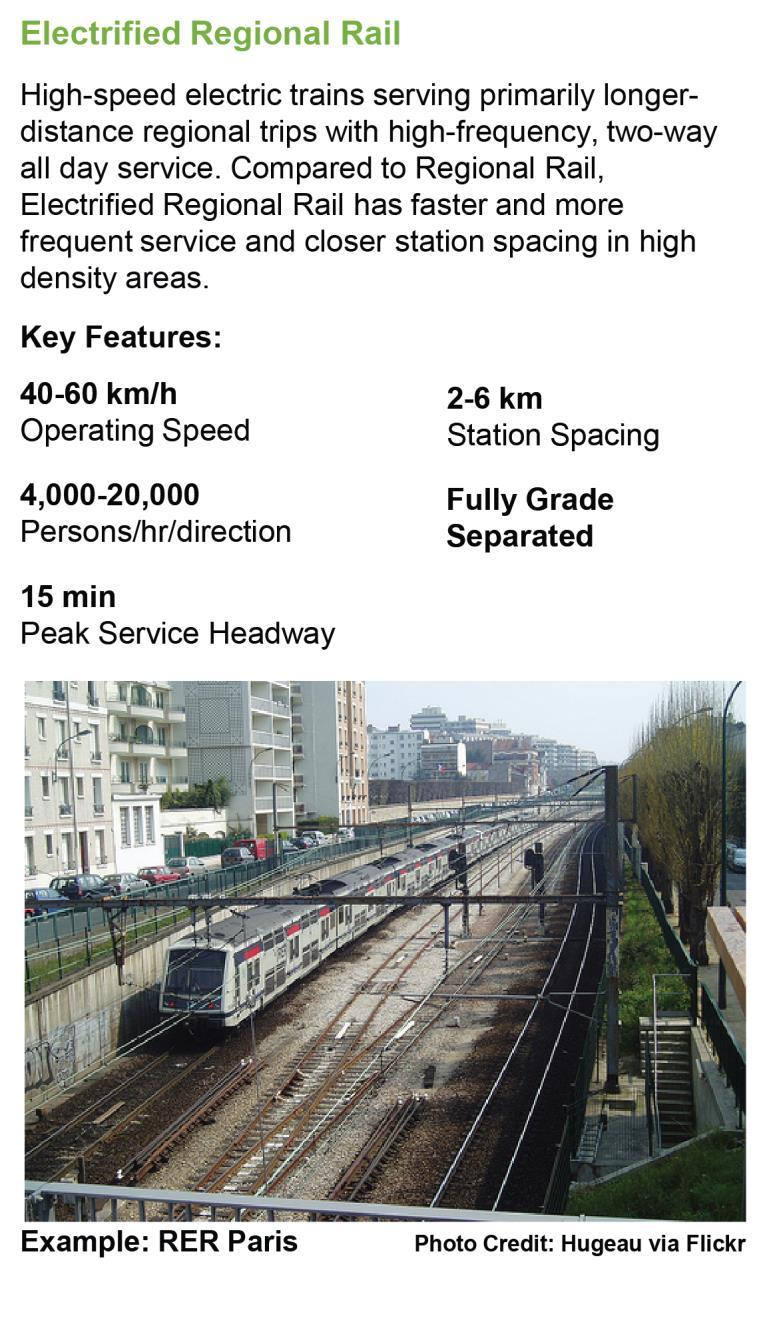
73 November 3,
74 5.1.3 Expanded Grid of Rapid Transit in Suburban Areas As discussed previously, there is a lack of mid-tier rapid transit services, especially in suburban areas, to address the growing travel demands within and between these regions and provide competitive options to the private automobile. LRT and BRT services can fill a crucial role in the regional grid of rapid transit services, supporting the frequent GO Rail and subway network, especially in high-growth areas, urban growth centres, and along high-demand regionally significant corridors. In lower density and emerging suburban areas, Priority Bus services can provide fast, frequent and reliable transit service without the need for expensive infrastructure, and can evolve into dedicated BRT or LRT corridors over time as demand grows. As part of a regional transit grid network providing a backbone of rapid transit throughout the region, these services would both connect with and provide circumferential service to the radial rapid transit network, as well as connecting, with local transit services. Local transit plays an important role in feeding the regional rapid transit network. Overall, the integration of these rapid transit services with existing regional and local transit services provides a connected web of services throughout the region, providing enhanced mobility and better serving the more dispersed travel patterns in suburban areas. Proposed transit improvements include: New/expanded BRT/LRT services, operating in dedicated lanes to provide speed and reliability benefits with other transit priority measures and branded vehicles and stations; Priority Bus services representing higher level-ofservice than conventional transit services, but with much lower capital cost than BRT/LRT, to allow greater coverage and expansion of a strategic-grid rapid transit network, especially in lower-density suburban areas. Priority bus features include branded vehicles and stations and the use of technology (e.g. traffic signal priority), low-cost infrastructure (e.g. queue jump lanes and highoccupancy vehicle lanes) and frequent all-day services to improve speed and reliability over conventional bus routes. Frequent Express Bus services, representing regional BRT-type services operating in managed lanes on 400-series and other highways, connecting and serving major centres in these corridors. Managed lanes include high-occupancy vehicle (HOV) lanes, toll facilities (e.g. Highway 407), and high-occupancy/toll (HOT) lanes, providing separation from mixed traffic and allowing higher operating speeds and reliability. These services would complement existing and expanded Regional Rail services. 64 November 3, 2017

75 November 3,

76 Priority Bus Both BRT Mixed traffic Frequent Service with queue jump Wider Station lanes at Spacing intersections Higher average operating speeds than mixed-traffic operations Signal Priority High Demand Reliable Off-Board Fares All-door boarding Well maintained Comfortable Stations Branding Semiexclusive ROW 2-way medianaligned busway 66 November 3, 2017

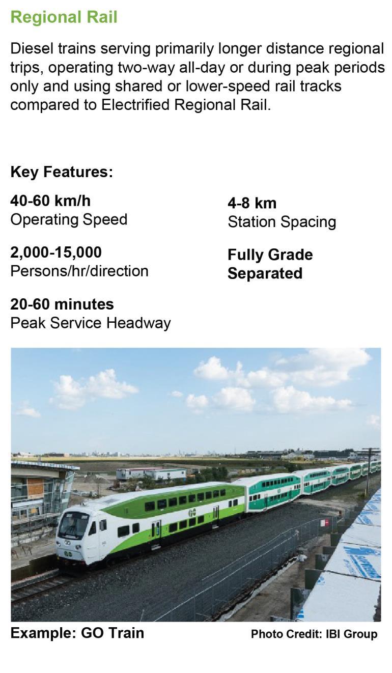
77 November 3,
78 5.2 Frequent Rapid Transit Network Many of the rapid transit services proposed as part of the 2041 Strategic Transit Network combine to form a network of frequent, reliable transit services that together are called the Frequent Rapid Transit Network. The Frequent Rapid Transit Network provides coverage and accessibility so that users can expect convenient, easyto-use services that are frequent enough all-day that they do not need to refer to a schedule. Frequent services also mean the transfer between transit services on the network involves short wait times for users, allowing convenient travel and region-wide access to multiple destinations. The Frequent Rapid Transit Network represents the core of the regional transit system. It provides effective transit access to regionallysignificant centres and trip generators and serves regionally significant travel markets to strongly support overall mobility, environmentally-sustainable development and the economic objectives of the region. The Frequent Rapid Transit Network is comprised of the following services: Frequent Regional Rail minimum 15 minute headway all-day two-way; Frequent Regional Express Bus minimum 15 minute headway all-day, and; Other Rapid Transit (Subway, LRT, BRT and Priority Bus) minimum 10 minute headway allday. Exhibit 5.1 presents the proposed 2041 Frequent Rapid Transit Network for the GTHA, representing the rapid transit services of frequent regional rail, subway, light rail transit, bus rapid transit, priority bus and frequent regional express bus services. The proposed network would provide rapid and frequent transit service within walking distance 5 to approximately 36% of GTHA residents and 46% of GTHA jobs in 2041, up from 9% and 21% in 2011, respectively. The following sub-sections present the proposed transit projects that comprise the 2041 Regional Frequent Rapid Transit Network. Each project is briefly described as to its function within the regional network, with its project number corresponding the numbering convention used in the network map shown in Exhibit 5.1 and Project Assessment Table in Exhibit Walking distance is 400 m from Priority Bus, BRT and LRT services, and 800 from Subway and Frequent Regional Rail services. 68 November 3, 2017

79 Exhibit 5.1: Proposed Frequent Rapid Transit Network November 3,
80 5.2.1 Frequent Regional Rail Frequent Regional Rail, represented by GO Rail 15- minute all-day service, is being implemented through the GO RER program and includes improvements to the Lakeshore East, Lakeshore West, Kitchener, Barrie, and Stouffville lines. Four Frequent Regional Rail projects are proposed beyond and the current RER program, as noted below. The implementation of the Milton and Lakeshore West Extension projects are, however, contingent upon major rail operational projects also being implemented to provide passenger service separation from freight traffic: Milton 15-min GO Service (Project #12) upgrade of the highly-utilized GO Rail Milton line with 15- minute all-day service from Union Station to Milton. Implementation of 15-minute all day service is contingent upon a new rail corridor linking the CN bypass line at Bramalea with the CP through-route near the Mississauga/Milton border and thereby separating major rail freight flows from passenger services on the GO Rail Milton and Kitchener lines and allowing electrification to be achieved. Lakeshore West 15-min GO Service Extension (#403) Extension of Lakeshore GO Rail 15-minute Service that is currently In Delivery, from Aldershot GO to Hamilton GO Centre to serve the downtown and urban growth centre. This improvement is contingent upon addressing the complex operational issues at Bayview Junction and the CP tunnel under Hunter Street. Barrie 15-min GO Service Extension (#450) this will extend 15-min service from Aurora GO to East Gwillimbury GO. Stouffville 15-min GO Service Extension (#451) this will extend the 15-minute Stouffville Service from Unionville GO to Mount Joy GO. Richmond Hill GO Rail 15-minute Service was analysed but was not included in the 2041 Transit Network as a 15-min service, given the additional capacity between central Toronto and York Region provided by the proposed Yonge North Subway Extension, Stouffville and Barrie 15-minute Services and challenges to connect with other transit services given the vertical grade differences when the alignment operates at the bottom of the Don Valley. Flooding and the indirect alignment within the Don Valley also pose operational issues that would need to be addressed. Richmond Hill All-Day Service is proposed, as noted in Section Regional Rail Frequent Regional Express Bus At present, Frequent Regional Express Bus services (with 15 minute all-day headway) do not currently exist, although Mississauga Transitway and 407 services represent high quality express bus services, with plans in place to enhance these services in the future. Frequent Express Bus services are assumed to operate in managed lanes (e.g. toll highway, high-occupancy vehicle lanes, high-occupancy/toll lanes) in order to provide the speed and reliability needed for an effective high-frequency service. The following Frequent Regional Express Bus services are proposed for the GTHA: Highway 407 Express Bus (#399) express bus service operating in managed/toll lanes on Highway 407 from Highway 35/115 through Durham, York, Peel and Halton Regions to the Queen Elizabeth Way, with stops at strategic locations, including 70 November 3, 2017
81 Markham, Richmond Hill, and Vaughan Urban Growth Centres. #399 operates exclusively Highway 407 #399a deviates from Highway 407 in Mississauga to operate on Highway 403/Mississauga Transitway and serve Mississauga City Centre. Highway 427 South Express Bus (#27) operation in planned managed lanes on Highway 427 between Highway 401 and the QEW and connecting to Pearson Airport and Bloor subway, and integrating with services using other Highway 427 segments. Highway 427 North Express Bus (#40) operation in planned managed lanes on Highway 427 between Highway 407 and Highway 401, and integrating with the Highway 407 Express Bus and other Highway 427 services. Highway 427 Extension Express Bus (#290) operation in managed lanes on the Highway 427 extension north to Major Mackenzie Drive, connecting with other Highway 427 services. Highway 401 Express Bus (#407) operating in managed lanes on Highway 401 from Oshawa to Milton, continuing as regular express bus(nonfrequent) to Cambridge. The feasibility of managed lanes on Highway 401 is subject to further study. Queen Elizabeth Way (QEW)/Gardiner Expressway Express Bus (#422) operating in managed lanes/existing HOV lanes on the QEW and continuing on the Gardner Expressway managed lanes to downtown Toronto and connecting to the Don Valley Parkway. The feasibility of managed lanes on the QEW/Gardiner is subject to further study. Don Valley Parkway (DVP)/Highway 404 Express Bus (#423) - operating in managed lanes/existing HOV lanes on the DVP/Highway 404 from the Gardiner Expressway in downtown Toronto to Davis Drive/Newmarket. The feasibility of managed lanes on the DVP/Highway 404 is subject to further study. Highway 400 Express Bus (#424) operating in planned managed lanes on Highway 400 from Highway 401 to Major Mackenzie Drive. Services continue north as regular express bus to Barrie Subway In Delivery subway projects include the Scarborough Subway to Scarborough Centre, and operational/capacity improvements to the Yonge Subway. The following subway improvements are included in the 2041 Frequent Rapid Transit Network: Yonge North Subway Extension (#17) extends north from Finch Station serving cross-boundary travel between York Region and Toronto with major transit connections to 407 Express Bus, VIVA, and serving the Richmond Hill Urban Growth Centre (UGC) and north Yonge Street corridor. Relief Line Subway (#35) new subway line providing additional capacity to Downtown Toronto and providing relief to the over-crowded Yonge Subway. The alignment extends from Union Station east and north along Pape Avenue to the Bloor- Danforth Subway and with a continued northward extension to the Sheppard Subway. November 3,
82 Sheppard Subway West Extension (#251) - extends the Sheppard Subway west to connect with the University Subway to better distribute ridership on the subway network with connections to the University-Spadina Line providing access to major destinations such York University and northwest Toronto and allowing the bypass of the congested Yonge Subway to serve central Toronto destinations. Line 2 Subway and Bloor-Yonge Station Capacity Enhancements (#307) train control/signalling improvements to increase capacity. The proposed Relief Line Subway West Extension (#401), extending west from Union Station and connecting to the Bloor-Danforth Subway in the vicinity of Dundas West Station is proposed beyond 2041, given the additional rapid transit capacity to Downtown Toronto from the west that will be provided by 2041 through proposed GO 15-minute services on the Milton and Kitchener rail lines LRT, BRT and Priority Bus There are 59 LRT, BRT and Priority Bus rapid transit projects included for implementation by 2041, providing significantly enhanced access to quality transit to the region s population. Exhibit 5.2 through Exhibit 5.5 present maps of the proposed new projects for the Frequent Rapid Transit Network, broken up into 4 geographic areas for presentation purposes. Toronto Exhibit 5.2 presents the LRT, BRT and Priority Bus rapid transit projects proposed for the City of Toronto, building on the existing rapid transit network and In Delivery projects (i.e. Eglinton Crosstown LRT, Finch West LRT, and Sheppard East LRT). The 14 projects to be included in the Frequent Rapid Transit Network address underserved areas in northwest and northeast Toronto, and other areas of Etobicoke and Scarborough as well as the Waterfront area: Sheppard East LRT Extension (#252) extension of the Sheppard East LRT that is currently In Delivery, extending it from Morningside Avenue to Meadowvale Road, providing access to the underserved east Scarborough area. Malvern Connection (#303) a branch or connector service from the Sheppard East LRT Extension above to serve Malvern Town Centre. Eglinton East LRT (#45) east extension of the Eglinton Crosstown LRT that is In Delivery, extending it from Kennedy subway station east along Eglinton Avenue to northward on Morningside Drive to Sheppard Avenue. This facility serves underserved, social need areas in east Scarborough and connects with the University of Toronto- Scarborough Campus, Malvern community, and the proposed Sheppard East LRT and Durham- Scarborough BRT facilities. Eglinton West LRT (#26) west extension of the Eglinton Crosstown that is In Delivery, with a new section from Black Creek Drive to Pearson Airport. Steeles BRT (#42) BRT section on Steeles Avenue from Stouffville GO/Milliken Station to Pioneer Village Station on the Spadina Subway Extension. Steeles Priority Bus (#409) Priority Bus section on Steeles Avenue west from Pioneer Village Station on the Spadina Subway Extension to Humber College. 72 November 3, 2017
83 Don Mills/Leslie BRT/LRT (#323) alignment from the Sheppard Subway and proposed Relief Line East north on Don Mills Road to the Steeles BRT and continuing in York Region on the Leslie BRT to Highway 7. TTC Airport Rocket (#411) enhanced existing service connecting Bloor-Danforth Subway at Kipling Station with Pearson Airport. McCowan South BRT/LRT (#44a) alignment from Ellesmere Road to Steeles Avenue, serving Scarborough Centre and connecting to the Sheppard East LRT that is In Delivery, and proposed Durham- Scarborough BRT and Steeles-Taunton Priority Bus services. Waterfront East LRT (#152) Union Station to Coxwell Avenue serving Downtown Toronto, east Waterfront area and Port Lands. Waterfront West LRT (#24) Union Station to Port Credit, serving Waterfront developments and Downtown Toronto. Jane South BRT/LRT (#28) alignment on Jane Street from Bloor-Danforth Subway to Steeles Avenue, serving an underserved and social need area and connecting with Jane North BRT in York Region. Finch West LRT West Extension (#253) west extension of the Finch West LRT that is In Delivery, extending it south via Highway 27 to Pearson Airport, serving underserved, social need areas in west Etobicoke and Rexdale and connecting to the airport area. Finch West LRT East Extension (#254) east extension of the Finch West LRT that is In Delivery, extending it from Spadina Subway to Yonge Subway in this high demand corridor. November 3,

84 Exhibit 5.2 Proposed Frequent Rapid Transit Network - Toronto 74 November 3, 2017
85 East Exhibit 5.3 displays the existing In Delivery rapid transit network and In Delivery projects in the East area and proposed 2041 improvements. The existing and In Delivery network includes Lakeshore East GO Rail 15- minute all-day service and the existing Priority Bus services between Oshawa and Scarborough via Highway 2 and Kingston Road/Ellesmere. These services provide an east-west spine for inter-regional flows to Downtown Toronto and Scarborough and intra- Durham travel linking the south Durham local municipalities. The following LRT, BRT and Priority Bus services, representing 9 projects, are proposed in the East, providing a rapid transit grid in Durham and enhanced cross-border transit services between Durham and Scarborough: Durham-Scarborough BRT (#30) east-west transit spine extending from Oshawa in the east to Scarborough Centre in the west, connecting local municipalities/downtowns in south Durham, east Scarborough and University of Toronto Scarborough Campus. Steeles/Taunton Priority Bus (#46) east-west spine through north Durham, continuing into Toronto/York Region via Steeles Avenue, connecting with the Toronto Steeles Avenue Priority Bus service and to the Milliken GO Station. Whites Priority Bus (#274) north-south transit spine in west Durham from Pickering GO to Highway 407. Brock Road Priority Bus (#31) north-south transit spine in west Durham with connections to Bayly Street Priority Bus, Durham-Scarborough BRT, Steeles Taunton Priority Bus and Highway 407 Express Bus services. Brock Street/Baldwin Priority Bus (#150) extending from Lakeshore East GO to Brooklin. Simcoe BRT (#47) north-south spine in east Durham, extending from Highway 2 to Highway 407 and serving Downtown Oshawa, future Oshawa GO Station and the University of Ontario Institute of Technology (UOIT). Bayly Priority Bus (#275) east-west link serving Pickering Centre and extending east to Whitby/Brock Street. Westney Priority Bus (#276) north-south link connecting with Bayly Road Priority Bus and Durham-Scarborough BRT service. Highway 2 Priority Bus (#421) service between Bowmanville and Oshawa on Highway 2, connecting and potentially interlining with the Durham- Scarborough BRT. November 3,

86 Exhibit 5.3 Proposed Frequent Rapid Transit Network - East 76 November 3, 2017
87 North Exhibit 5.4 shows the proposed 2041 frequent transit network for the North area. The Spadina Subway extension to Vaughan Metropolitan Centre, completion of Viva BRT on Highway 7 and Yonge Street provide major new north-south and east-west spines in York Region and connections to the northern areas of the City of Toronto. The proposed transit projects for 2041 build on these network spines to develop additional east-west and north-south services and provide full grid to serve intra-york Region travel and cross-border travel. A total of 10 LRT, BRT and Priority Bus projects are proposed in the North area as part of the 2041 Frequent Rapid Transit Network: Major Mackenzie BRT (#127) BRT service in the central section of Major Mackenzie Drive from Leslie Street to Jane Street, with east and west Priority Bus continuous service connections. Major Mackenzie East Priority Bus (#287) east extension of the Major Mackenzie service as Priority Bus from Leslie Street to the Stouffville GO line. Major Mackenzie West Priority Bus (#289) west extension of the Major Mackenzie service from Jane Street to Highway 427. Jane North BRT (#125) north-south BRT service extending from Major Mackenzie Drive to the proposed Jane BRT/LRT in Toronto. Leslie North BRT (#126) BRT service connecting with the Don Mills/Leslie BRT/LRT (#323) at Steeles Avenue and continuing north to Major Mackenzie Drive BRT. McCowan North Priority Bus (#44b) service on McCowan Road from Steeles Avenue to Highway 7/Centennial GO Station, with continuous or connected service with the McCowan BRT/LRT service in Toronto. Highway 7 West BRT Extension (#284) west extension of the Highway 7 BRT that is In Delivery, extending it from Helen Street to Highway 50 and connecting as a continuous service with the Brampton Queen Street BRT. Highway 7 East BRT Extension (#285) east extension of the Highway 7 BRT that is In Delivery from the Unionville GO station to Donald Cousens Parkway. Yonge BRT (#286) BRT service connecting Richmond Hill, Aurora and Newmarket. Green Lane Priority Bus (#43) extension of the Yonge Street Priority Bus north and then eastward along Green Lane. November 3,

88 Exhibit 5.4 Proposed Frequent Rapid Transit Network North 78 November 3, 2017
89 West The 2041 Frequent Transit Network for the West area of the GTHA, including Peel and Halton Regions, is shown in Exhibit 5.5. A total of 21 proposed projects are identified. Within Peel Region, the 12 proposed LRT, BRT and Priority Bus rapid transit projects focus on expanding the grid network of rapid transit services to serve intra-peel trips and support urban growth centres and mobility hubs, leveraging the Hurontario LRT spine that is In Delivery and the existing rapid transit network: Downtown Mississauga Transitway and Terminal (#270) direct connection of the existing Mississauga Transitway into Mississauga City Centre with terminal improvements. Dundas BRT (#20a) BRT facility providing an eastwest spine in south Peel Region, extending from Kipling Subway Station in Toronto to Trafalgar Road and the Trafalgar Priority Bus. Its connection with the proposed Dundas Priority Bus provides continuous east-west west service along Dundas Street, the main travel corridor within Peel and Halton Regions. Brampton Queen Street BRT (#25) east-west transit spine through Brampton, connecting to the Brampton GO Station in the west to the Highway 7 BRT service in York Region. Steeles Priority Bus (#39) Steeles Avenue from Highway 427 with diversion from Humber College and connection with the Toronto Steeles Avenue Priority Bus and extending westward to Mississauga Road connecting to the Erin Mills Priority Bus and Lisgar GO Station. Bovaird/Castlemore Priority Bus (#404) alignment along high growth corridor along Bovaird Road/Castlemore Road from Highway 427 to Mississauga Road/Mt. Pleasant GO station. Brampton Main LRT (#23) north extension of the In Delivery section of the Hurontario LRT, extending north from Brampton Gateway (near Steeles Avenue) to the Brampton GO Station. Derry Priority Bus (#416) east-west spine through northern Peel Region, serving the Airport area and connecting with the proposed Halton Derry Road Priority Bus. Brittania-Matheson Priority Bus (#406) east-west spine service through central Mississauga and serving the Airport area. Hurontario North/Mayfield Priority Bus (#22) north extension of the Hurontario LRT from Queen Street to the Mayfield West community. Dixie Priority Bus (#408) north-south transit spine in east Peel Region, extending from Lakeshore Boulevard to the Bramalea GO station and Mayfield Road, and providing service to the Airport area. Airport Road Priority Bus (#420) extending from Bovaird Road to the Airport area and mobility hub. Erin Mills Priority Bus (#405) north-south spine from Steeles Avenue in the north along Mississauga Road, Erin Mills Parkway and Southdown Road and connecting to Clarkson GO. November 3,

90 Exhibit 5.5 Proposed Frequent Rapid Transit Network West and Hamilton 80 November 3, 2017
91 Within Halton Region, the focus of the 2041 transit network is to support development and urban growth centres/mobility hubs and Halton travel by establishing an east-west transit spine, quality transit connections to adjacent municipalities, and a north-south connection to Milton. There are 9 proposed Priority Bus rapid transit projects in Halton Region: Trafalgar South Priority Bus (#21) alignment extending from the Lakeshore West Oakville GO Station north to Highway 407, with connections to the proposed Dundas BRT and Highway 407 Express Bus services. Trafalgar North Priority Bus (#38) northern alignment of the proposed Trafalgar South Priority Bus, extending north from Highway 407 to the Milton GO station. Harvester/Speers/Cornwall Priority Bus (#312) operating between Brant Street and Hurontario, serving local employment in Burlington, Oakville and Mississauga. Milton Main Priority Bus (#313) connection to Downtown Milton. Dundas West Priority Bus (#20b) priority bus service connecting with the Peel Dundas BRT at Trafalgar Road and providing continuous Dundas service to Brant Street in Burlington. Derry Priority Bus (#311) alignment extending from Winston Churchill in the east to Tremaine Road in the west. Bronte Road/Regional Road #25 Priority Bus (#144) north-south transit spine from Harvester Road to the Town of Milton. Brant Priority Bus (#37) Brant Street corridor from Dundas Street to Harvester Road and continuing as the proposed Burlington Connector. Brant Priority Bus (#19) Brant Street alignment connecting to the Burlington UGC, with continued service on the proposed Brant Street Priority Bus and intersecting with the proposed Harvester/Speers/Cornwall Priority Bus. Hamilton The existing, In Delivery and proposed rapid transit facilities that comprise the 2041 Frequent Rapid Transit Network for Hamilton is shown in Exhibit 5.5. The Hamilton B Line LRT is an In Delivery project that provides a high-order transit spine to support the planned urban form and the Hamilton Urban Growth Centre. The proposed transit projects to be introduced into the 2041 Regional Frequent Rapid Transit Network builds on the B Line, contributing to a focus on moving people to and within Hamilton. The 5 proposed BRT and Priority Bus projects include: Hamilton A Line BRT (#18a) alignment from Rymal Road to Downtown Hamilton, connecting upper and lower Hamilton in a major travel corridor. Hamilton A Line South Priority Bus (#18b) extension of the Hamilton A Line above, continuing to Hamilton Munro International Airport. Dundas Connector Priority Bus (#263b) extension of the B Line LRT that is In Delivery, extending it west from McMaster University to the Town of Dundas. Hamilton Mohawk T Line Priority Bus (#36) an outer grid/circumferential alignment connecting from east Hamilton to an east-west transit spine along Mohawk Road in upper Hamilton to the Town of Ancaster. November 3,
92 Hamilton L Line Priority Bus (#260) alignment from Waterdown to Downtown Hamilton. 5.3 Regional Express Transit Network A second key aspect of the 2041 Strategic Transit Network is the provision of regional express transit services to primarily serve long-distance travel between GTHA municipalities outside of Toronto and to provide region-wide coverage. Given the distances, these regional services primarily utilize rail corridors and the highway system to connect and serve regionallysignificant markets that are important to be connected within the regional transit network, and provide connections to major centres, mobility hubs, park-andride facilities, and access to other rapid transit and local transit services. The services that comprise the Regional Express Transit Network include: Frequent Regional Rail as already defined in the Frequent Rapid Transit Network. (i.e. Frequent GO Rail, Frequent Express Bus). Regional Rail to serve areas not covered by GO Rail 15-minute all-day service. Service may be provided infrequently all-day (e.g. hourly) or during peak periods only. Frequent Regional Express Bus as already defined in the Frequent Rapid Transit Network. Regional Express Bus including service to regionally-significant areas not served by the Frequent Rapid Transit Network. Combined, the Frequent Rapid Transit Network and the Regional Express Transit Network provide integrated transit services across the region, designed to meet the future needs of regionally-significant travel throughout the GTHA. The existing and 2041 proposed Regional Express Transit Network is shown in Exhibit 5.6. As noted, the regional network serves long-distance inter-regional travel throughout the Region, primarily using existing rail corridors and the highway system. The proposed Regional Express Transit Network builds on existing regional transit services, notably Regional Rail (i.e. GO Rail) and the GO Bus network, as well as current planning by GO Transit to develop a 2021 Strategic GO Bus Network. A total of 24 new services are proposed for the Regional Express Transit Network. Frequent Regional Rail and Frequent Regional Express Bus services meet the definition of frequent service with headways of 15 minutes or less all day, and thus are also included as part of the Frequent Rapid Transit Network in the previous section.. 82 November 3, 2017

93 Exhibit 5.6 Proposed Regional Express Transit Network November 3,
94 5.3.1 Frequent Regional Rail The Frequent Regional Rail system, as defined by GO Rail 15-minute all-day service, is common to both the Frequent Rapid Transit Network and the Regional Express Transit Network. Please refer to Section for a summary of the proposed Frequent Regional Rail improvements Regional Rail The Regional Rail system performs a reduced role in 2041 as GO Rail 15-minute services are introduced through the conversion of existing Regional Rail corridors to electrified, high-frequency corridors, including Lakeshore East, Lakeshore West, Milton, Georgetown, and Stouffville lines. Regional Rail improvements that are In Delivery include the extension of Lakeshore East to Bowmanville Peak Period Service, and the Niagara GO Service Extension from Hamilton to Niagara Falls Extensions and expansion of Regional Rail were examined in all rail corridors. Two Regional Rail improvement are identified for the 2041 Regional Express Transit Network: Richmond Hill All-Day GO Service (# 452) upgraded service on the existing Richmond Hill GO Service from Peak Period to All Day from Union Station to Richmond Hill GO. Lakeshore East All-Day GO Service (#453) extending from Oshawa GO to Martin Road, Bowmanville. Expansion of Regional Rail services to Cambridge, Bolton, Mid-Toronto, Uxbridge, Peterborough were analyzed but are proposed for post A Cambridge GO Transit Extension (#141), extending from the Milton GO to Cambridge has feasibility contingent upon track improvements to double track the line from Guelph Junction to accommodate the additional demands of passenger rail services. Bolton GO Rail Service (#13) has low projected ridership given the low overall travel demand between Bolton, Woodbridge and Downtown Toronto (see the priority bus recommendation for Bolton in the following sub-section below). Seaton GO Rail (#16) would serve travel between north Durham/Seaton and mid-toronto at Summerhill using the North Toronto subdivision, but projected ridership is low and further study is needed to determine the feasibility of service, including constraints at Agincourt Yard. Crosstown GO Rail - Kipling to Summerhill (#14) connects mid- and west Toronto has low projected ridership as it serves a similar market to the Bloor- Danforth subway and Eglinton Crosstown LRT. While not proposed for the 2041 Transit Network, Regional Rail service using the North Toronto Subdivision (including Project #16 above) would provide a second east-west service that would not be susceptible to potential capacity restraints at Union Station and thus should be maintained as a future option beyond 2041.Extension of the Stouffville GO to Uxbridge (#148), and GO service on the Havelock Subdivision to Peterborough are projected to have low ridership estimate, with large infrastructure investments also required for a Peterborough service Frequent Regional Express Bus Regional Express Bus services that meet the frequent definition are included in the Frequent Rapid Transit 84 November 3, 2017
95 Network, and also form a key element of the Regional Express Transit Network. These include services on major highways including Highways 400, 403, 404, Gardiner Expressway, and Don Valley Parkway. Please refer to Section for the list of proposed Frequent Regional Express Bus service Regional Express Bus The following Express Bus services will provide highspeed, high-quality service for long-distance travel to centres in more rural areas of the GTHA that are not connected to the Frequent Rapid Transit Network. Service headways on Regional Express Bus routes are planned to be hourly all day or better. The Regional Express Bus Network builds on the GO Bus system and planned regional routes. It provides transit service connections to secondary centres such as Bolton, Stouffville, Uxbridge and Orangeville that would otherwise be unserved in the regional system, as well as express bus connections to external GTHA centres such as Barrie, Peterborough, Brantford, Cambridge and Kitchener. There are 11 Regional Express Bus services that are proposed for the 2041 Regional Express Transit Network to supplement and interline with services on the Frequent Regional Express Bus Network: Highway 35 Oshawa to Peterborough (#500) Oshawa GO and Downtown Oshawa to Downtown Peterborough and Trent University. Highway 400 Barrie to Yorkdale (#501) Downtown Barrie to Yorkdale via Highway 400 and utilizing proposed Highway 400 managed lanes to Yorkdale. Highway 400 Barrie to Pearson Airport (#502) Downtown Barrie to Pearson Airport via Highway 400 and proposed managed lane services on Highway 401 and Highway 427. Highway 8 Kitchener to Hamilton (#503) Downtown Kitchener to Cambridge, McMaster University, and Hamilton GO Centre via Highway 8. Highway 6 Guelph to Hamilton (#504) Downtown Guelph and University of Guelph to McMaster University and Hamilton GO Centre via Highway 6. Highway 7 Kitchener to Brampton (#505) Brampton GO to Georgetown, Acton, Guelph, University of Guelph and Kitchener via Highway 7. QEW Hamilton to Niagara Falls (#506) Hamilton GO Centre to St Catharines, Brock University, and Niagara Falls via QEW and Highway 406. Highway 48 Uxbridge to Markham (#507) Uxbridge to Stouffville to Markham Centre. Highway 10 Orangeville to Brampton (#508) Orangeville to Brampton GO via Highway 10 and Hwy 410. Highway 27 Bolton to Vaughan (#509) Bolton to Vaughan Metropolitan Centre via Highway 50 and Highway 407. Highway 403 Brantford to Hamilton (#510) Brantford to McMaster University and Hamilton GO Centre via Highway 403. November 3,
96 5.4 Next Steps As part of Phase 1 tasks, the above proposed Frequent Rapid Transit Network and Regional Express Transit Express Network will be circulated for comment among GTHA municipalities and agencies, as well as internal Metrolinx review and costing, and are thus presented as, preliminary for discussion purposes, based on analysis and information to date. With feedback, the 2041 networks will be refined and updated for inclusion in the final 2041 Regional Transportation Plan. Phase 2 of the study will focus on implementation issues and planning, including a phasing strategy, potential roles of transit operators, and implementation framework. 86 November 3, 2017
97 Appendix A Rapid Transit Plans of GTHA Regional Municipalities and Local Municipalities
98 List of Maps City of Toronto - Recommended Rapid Transit to be Built within Next 15 Years Relief Line Project Assessment Study Area York Region 2041 Transit Network Durham Region 2031 Transit Map MiWay 2020 Proposed Service Plan Brampton 2041 Recommended Rapid Transit Network Phasing 1 Brampton 2041 Recommended Rapid Transit Network Phasing 2 Brampton 2041 Recommended Rapid Transit Network Phasing 3 Halton Region 2031 Transit Corridors Hamilton Long Term Rapid Transit System November 3, 2017

99 City of Toronto - Recommended Rapid Transit to be Built within Next 15 Years Source: Developing Toronto s Transit Network Plan: Phase A.1 November 3, 2017

100 Relief Line Project Assessment Study Area p Source: Developing Toronto s Transit Network Plan: Phase A.2 November 3, 2017

101 York Region 2041 Transit Network Source: York Region TMP 2016 A.3 November 3, 2017

102 Durham Region 2031 Transit Map Source: Durham TMP 2017 A.4 November 3, 2017

103 MiWay 2020 Proposed Service Plan Source: MiWay Five Year Service Plan 2015 A.5 November 3, 2017

104 Brampton 2041 Recommended Rapid Transit Network Phasing 1 A.6 November 3, 2017

105 Brampton 2041 Recommended Rapid Transit Network Phasing 2 A.7 November 3, 2017

106 Brampton 2041 Recommended Rapid Transit Network Phasing 3 Source: Brampton Transportation Master Plan Update 2015 A.8 November 3, 2017

107 Halton Region 2031 Transit Corridors Source: Halton TMP 2011 A.9 November 3, 2017

108 Hamilton Long Term Rapid Transit System Source: Hamilton Rapid Ready 2013 A.10 November 3, 2017
Mr. Vince Mauceri General Manager Transportation Operations and Technology
 Mr. Vince Mauceri General Manager Transportation Operations and Technology METROLINX OVERVIEW AND MANDATE Established in 2006 to address the significant transportation challenges in the Greater Toronto
Yonge-Eglinton. Mobility Hub Profile. September 19, 2012 YONGE- EGLINTON
 September 19, 2012 PEEL YORK HALTON DURHAM HAMILTON TORONTO YONGE- EGLINTON MOBILITY HUBS: places of connectivity between regional and rapid transit services, where different modes of transportation come
TORONTO TRANSIT COMMISSION REPORT NO.
 Form Revised: February 2005 TORONTO TRANSIT COMMISSION REPORT NO. MEETING DATE: October 24, 2012 SUBJECT: DOWNTOWN RAPID TRANSIT EXPANSION STUDY (DRTES) PHASE 1 STRATEGIC PLAN ACTION ITEM RECOMMENDATIONS
5 RAPID TRANSIT NETWORK PLAN PRINCIPLES, METROLINX BUSINESS CASE, AND ALTERNATIVE FINANCE AND PROCUREMENT ANALYSIS UPDATE
 5 RAPID TRANSIT NETWORK PLAN PRINCIPLES, METROLINX BUSINESS CASE, AND ALTERNATIVE FINANCE AND PROCUREMENT ANALYSIS UPDATE The Rapid Transit Public/Private Partnership Steering Committee recommends the
CONNECTING THE REGION
 CONNECTING THE REGION GERRY CHAPUT VICE PRESIDENT, RAPID TRANSIT, METROLINX VALUE ANALYSIS CANADA SUMMIT KEYNOTE OCTOBER 16, 2017 Metrolinx was created in 2006 by the Province of Ontario to improve the
The City of Toronto s Transportation Strategy July 2007
 The City of Toronto s Transportation Strategy July 2007 Presentation Outline Transportation Statistics Transportation Building Blocks Toronto s Official Plan Transportation and City Building Vision Projects
Metrolinx: Transforming the Way We Move - A Network Wide Approach. Greg Percy, Chief Operating Officer November 1, 2016
 Metrolinx: Transforming the Way We Move - A Network Wide Approach Greg Percy, Chief Operating Officer November 1, 2016 2 Greater Toronto & Hamilton Area Total Population in the GTHA Total Population 2001-2041
GO Transit s deliverable: the 2020 Service Plan
 GO Transit s deliverable: the 2020 Service Plan GO Transit s 2020 Service Plan describes GO s commitment to customers, existing and new, to provide a dramatically expanded interregional transit option
2.1 TRANSIT VISION 2040 FROM VISION TO ACTION. Expand regional rapid transit networks STRATEGIC DIRECTION
 TRANSIT VISION 2040 FROM VISION TO ACTION TRANSIT VISION 2040 defines a future in which public transit maximizes its contribution to quality of life with benefits that support a vibrant and equitable society,
PROJECT BACKGROUND 3
 AGENDA 1. Welcome & Introductions 2. Project Background 3. Project Approach & Schedule 4. Draft Long List of Options 5. Evaluation Process 6. Next Steps 2 PROJECT BACKGROUND 3 OUR RAPID TRANSIT NETWORK
V03. APTA Multimodal Operations Planning Workshop August Green Line LRT
 V03 APTA Multimodal Operations Planning Workshop August 2016 Green Line LRT 2 Presentation Outline Past Present Future 3 16/03/2016 RouteAhead Update 4 4 16/03/2016 RouteAhead Update 5 5 16/03/2016 6 6
Yonge Relief Network Study (YRNS)
") Yonge Relief Network Study (YRNS) Report for June 25 th Metrolinx Board Meeting Leslie Woo, Chief Planning Officer Anna Pace, Director, Project Planning and Development Summary of Yonge Relief Network
Yonge Relief Network Study (YRNS) Report for June 25 th Metrolinx Board Meeting Leslie Woo, Chief Planning Officer Anna Pace, Director, Project Planning and Development Summary of Yonge Relief Network
GTA West Corridor Planning and EA Study Stage 1
 GTA West Corridor Planning and EA Study Stage 1 Draft Development Strategy Presentation to Peel Goods Movement Task Force April 8 2011 Study Areas 2 Unique Approach Unprecedented two-stage EA process:
APPENDIX 6: Transportation Modelling Considerations City of Toronto, February 2014
 APPENDIX 6: Transportation Modelling Considerations City of Toronto, February 2014 Transportation and Infrastructure The future of the elevated Gardiner Expressway east of Jarvis Street forms part of a
CONNECTING THE REGION
 CONNECTING THE REGION JUDY PFEIFER CHIEF COMMUNICATIONS & PUBLIC AFFAIRS OFFICER LESLIE WOO CHIEF PLANNING OFFICER, PLANNING & POLICY PRESENTED AT AMO INSIGHT BREAKFAST SESSION AUGUST 14, 2017 7:15AM 8:15AM
The Regional Transportation Plan PLAN BUILD OPERATE
 WHO IS METROLINX? Metrolinx was created in 2006 by the Province of Ontario as the first Regional Transportation Agency for the Greater Toronto and Hamilton Area (GTHA). The Regional Transportation Plan
CONNECTING THE REGION
 CONNECTING THE REGION MARY PROC, VICE PRESIDENT, CUSTOMER SERVICE DELIVERY, METROLINX NATIONAL RAILWAY DAY NOVEMBER 7, 2017 OUR NEW CEO PHIL VERSTER I am very excited about joining the team of dedicated
Scarborough Transit Planning
 Scarborough Transit Planning April 23, 2016 Transportation Planning Section City Planning Division Overview 1. Developing Toronto s Transit Network Plan 2. Scarborough Transit Planning 1. Minutes of last
CITY OF LONDON STRATEGIC MULTI-YEAR BUDGET ADDITIONAL INVESTMENTS BUSINESS CASE # 6
 2016 2019 CITY OF LONDON STRATEGIC MULTI-YEAR BUDGET ADDITIONAL INVESTMENTS BUSINESS CASE # 6 STRATEGIC AREA OF FOCUS: SUB-PRIORITY: STRATEGY: INITIATIVE: INITIATIVE LEAD(S): BUILDING A SUSTAINABLE CITY
Developing Toronto s Transit Network Plan to Public Information Meeting June 21, 2016
 Developing Toronto s Transit Network Plan to 2031 Public Information Meeting June 21, 2016 March 2016 City Council Direction SmartTrack: Approved SmartTrack/GO Regional Express Rail (RER) Integration options
Attachment 5 Eglinton West LRT Planning and Technical Update
 Eglinton West LRT Planning and Technical Update 1. Introduction In July 2016, City Council approved an Eglinton West LRT with between 8 and 12 stops between Mount Dennis and Renforth Gateway, and up to
Benchmarking, Planning, and Promoting Transit- Oriented Intensification in Rapid Transit Station Areas: Project Key Indicators March 2016
 Benchmarking, Planning, and Promoting Transit- Oriented Intensification in Rapid Transit Station Areas: Project Key Indicators March 2016 This project was produced by MITL with support from the Government
Future Needs Assessment Report
 Background Report Future Needs Assessment Report York Region Transportation Master Plan by IBI Group June 2016 Table of Contents 1 Introduction... 1 1.1 TMP Update Process... 1 1.2 Purpose of Report...
Appendix G: Rapid Transit Technology Backgrounder July 2017
 Appendix G: Rapid Transit Technology Backgrounder This appendix provides additional details regarding Bus Rapid Transit and Light Rail Transit technologies, with examples from other systems, including:
2.4 TRANSIT VISION 2040 FROM VISION TO ACTION. Support the revitalization of urban cores STRATEGIC DIRECTION
 TRANSIT VISION 2040 FROM VISION TO ACTION TRANSIT VISION 2040 defines a future in which public transit maximizes its contribution to quality of life with benefits that support a vibrant and equitable society,
Journey to Excellence. Building Markham s Future Together. Development Services Committee. Transit. Update. June 23, 2015
 Development Services Committee June 23, 2015 Building Markham s Future Together Transit Update Presentation: 1. Overview of Metrolinx 2. The Big Move 3. Projects Update 4. Investment Strategy 5. Next Steps
Yonge Subway Extension Breakfast Meeting
 Yonge Subway Extension Breakfast Meeting May 12, 2011 1 breakfast meeting overview 1. Welcome 2. Rapid Transit overview Yonge Subway Funding Call to action 3. Commentary 4. Open discussion 5. Closing remarks
Issues Facing the Panel
 Issues Facing the Panel Choice of technology for Sheppard Avenue (not for every corridor every where for all time!): subway vs. LRT Budget implications I would argue that procurement, construction management
Executive Summary. Draft Environmental Impact Statement/Environmental Impact Report ES-1
 Executive Summary Introduction The Eastside Transit Corridor Phase 2 Project is a vital public transit infrastructure investment that would provide a transit connection to the existing Metro Gold Line
Executive Summary. Treasure Valley High Capacity Transit Study Priority Corridor Phase 1 Alternatives Analysis October 13, 2009.
 Treasure Valley High Capacity Transit Study Priority Corridor Phase 1 Alternatives Analysis October 13, 2009 Background As the Treasure Valley continues to grow, high-quality transportation connections
The Engineering Department recommends Council receive this report for information.
 CORPORATE REPORT NO: R161 COUNCIL DATE: July 23, 2018 REGULAR COUNCIL TO: Mayor & Council DATE: July 19, 2018 FROM: General Manager, Engineering FILE: 8740-01 SUBJECT: Surrey Long-Range Rapid Transit Vision
Presentation A Blue Slides 1-5.
 Presentation A Blue Slides 1-5. 1 Presentation A Blue Slides 1-5. 2 Presentation A Blue Slides 1-5. 3 Presentation A Blue Slides 1-5. 4 Presentation A Blue Slides 1-5. 5 Transit Service right. service
Metro Reimagined. Project Overview October 2017
 Metro Reimagined Project Overview October 2017 Reimagining Metro Transit Continuing our Commitment to: Provide mobility based on existing and future needs Value the role of personal mobility in the quality
STRATEGIC PRIORITIES AND POLICY COMMITTEE MAY 5, 2016
 STRATEGIC PRIORITIES AND POLICY COMMITTEE MAY 5, 2016 Shift Rapid Transit Initiative Largest infrastructure project in the city s history. Rapid Transit initiative will transform London s public transit
Public Meeting. City of Chicago Department of Transportation & Department of Housing and Economic Development
 Public Meeting City of Chicago Department of Transportation & Department of Housing and Economic Development Funded by Regional Transportation Authority September 12, 2011 In partnership with Presentation
DS Discussion Paper. for the Next Regional Transportation Plan GREATER TORONTO AND HAMILTON AREA AUGUST 2016
 DS-16-163 Discussion Paper for the Next Regional Transportation Plan GREATER TORONTO AND HAMILTON AREA AUGUST 2016 ABOUT METROLINX AND THE REGIONAL TRANSPORTATION PLAN As the regional transportation agency
CREATING CONNECTIONS IN THE TOWN OF NEWMARKET
 CREATING CONNECTIONS IN THE TOWN OF NEWMARKET NICK SPENSIERI, DIRECTOR, CORRIDOR INFRASTRUCTURE METROLINX ERIN MOROZ, DIRECTOR, COMMUNICATIONS AND COMMUNITY RELATIONS METROLINX APRIL 10, 2017 GRIDLOCK
Public Information Session June 2, Transportation Planning Section City Planning Division Toronto Transit Commission
 Coordinated Transit Planning in Toronto SmartTrack/GO RER Eglinton West LRT Eglinton East LRT Scarborough Subway Extension Relief Line Waterfront Transit Public Information Session June 2, 2016 Transportation
Service Quality: Higher Ridership: Very Affordable: Image:
 Over the past decade, much attention has been placed on the development of Bus Rapid Transit (BRT) systems. These systems provide rail-like service, but with buses, and are typically less expensive to
Calgary Transit and the Calgary Transportation Plan Chris Jordan, M.Sc., P.Eng. Coordinator, Strategic Transit Planning, Calgary Transit
 Calgary Transit and the Calgary Transportation Plan Chris Jordan, M.Sc., P.Eng. Coordinator, Strategic Transit Planning, Calgary Transit 1. Plan It Calgary the new Municipal Development Plan and Calgary
CITY OF VAUGHAN EXTRACT FROM COUNCIL MEETING MINUTES OF NOVEMBER 21, 2017
 CITY OF VAUGHAN EXTRACT FROM COUNCIL MEETING MINUTES OF NOVEMBER 21, 2017 Item 1, Report No. 41, of the Committee of the Whole (Working Session), which was adopted without amendment by the Council of the
A Transit Plan for the Future. Draft Network Plan
 A Transit Plan for the Future Draft Network Plan Project Overview and Status Completed Market Analysis and Service Evaluation. Developed Plan Framework and Guiding Principles. Developed a draft Five Year
RELIEF LINE PRELIMINARY BENEFITS CASE ANALYSIS. November 2012
 RELIEF LINE PRELIMINARY BENEFITS CASE ANALYSIS November 2012 Relief Line Preliminary Benefits Case Analysis Final Report November 2012 CONTENTS EXECUTIVE SUMMARY... 3 PART A PROJECT RATIONALE... 10 CONTEXT
Yonge Subway Extension. driving progress in the GTA» more transit, stronger economy and cleaner environment
 Yonge Subway Extension driving progress in the GTA» more transit, stronger economy and cleaner environment message from the Chairman of the Board The continued success and competitiveness of our region
Developing Toronto s Transit Network Plan to 2031
 RE:EX16.1 Developing Toronto s Transit Network Plan to 2031 Executive Committee Meeting June 28, 2016 March 2016 City Council Direction SmartTrack: Approved SmartTrack/GO Regional Express Rail (RER) Integration
5. OPPORTUNITIES AND NEXT STEPS
 5. OPPORTUNITIES AND NEXT STEPS When the METRO Green Line LRT begins operating in mid-2014, a strong emphasis will be placed on providing frequent connecting bus service with Green Line trains. Bus hours
UTA Transportation Equity Study and Staff Analysis. Board Workshop January 6, 2018
 UTA Transportation Equity Study and Staff Analysis Board Workshop January 6, 2018 1 Executive Summary UTA ranks DART 6 th out of top 20 Transit Agencies in the country for ridership. UTA Study confirms
Form Revised: February 2005 TORONTO TRANSIT COMMISSION REPORT NO. MEETING DATE: August 30, SUBJECT: Scarborough Rt Strategic Plan
 Form Revised: February 2005 TORONTO TRANSIT COMMISSION REPORT NO. MEETING DATE: August 30, 2006 SUBJECT: Scarborough Rt Strategic Plan RECOMMENDATIONS It is recommended that the Commission: 1. Endorse
FREQUENTLY ASKED QUESTIONS
 FREQUENTLY ASKED QUESTIONS 2018 What is the More MARTA Atlanta program? The More MARTA Atlanta program is a collaborative partnership between MARTA and the City of Atlanta to develop and implement a program
The Preferred Alternative: a Vision for Growth on the Northeast Corridor
 A Long-Term Vision is Needed The Preferred Alternative: a Vision for Growth on the Northeast Corridor The Federal Railroad Administration (FRA) has released the Tier 1 Final Environmental Impact Statement
Re: EX16.1. Developing Toronto's Transit Network Plan to Attachment 5
 Re: EX16.1 Developing Toronto's Transit Network Plan to 2031 1 Contents 1. Executive Summary... 3 2. Background and Context... 7 Problem Statement... 9 Decision History on Options Development... 10 Options
Public Meeting. March 21, 2013 Mimosa Elementary School
 Public Meeting March 21, 2013 Mimosa Elementary School Today s Meeting Purpose 2 Where We Are The Process What We ve Heard and Findings Transit Technologies Station Types Break-out Session Where We Are
EGLINTON CROSSTOWN LIGHT RAIL TRANSIT (LRT)
") WELCOME TO OUR PUBLIC OPEN HOUSE EGLINTON CROSSTOWN LIGHT RAIL TRANSIT (LRT) Preliminary Planning for a Transit Project Assessment Open House Martin Grove Road to Pearson International Airport September
WELCOME TO OUR PUBLIC OPEN HOUSE EGLINTON CROSSTOWN LIGHT RAIL TRANSIT (LRT) Preliminary Planning for a Transit Project Assessment Open House Martin Grove Road to Pearson International Airport September
EGLINTON CROSSTOWN LIGHT RAIL TRANSIT (LRT) PLEASE SIGN IN
 PLEASE SIGN IN") WELCOME TO OUR PUBLIC OPEN HOUSE EGLINTON CROSSTOWN LIGHT RAIL TRANSIT (LRT) Preliminary Planning for a Transit Project Assessment June 15, 17, 18, 23, 24 and 25, 2009 PLEASE SIGN IN Members of the Project
WELCOME TO OUR PUBLIC OPEN HOUSE EGLINTON CROSSTOWN LIGHT RAIL TRANSIT (LRT) Preliminary Planning for a Transit Project Assessment June 15, 17, 18, 23, 24 and 25, 2009 PLEASE SIGN IN Members of the Project
Executive Summary. Phase 2 Evaluation Report. Introduction
 , Executive Summary Executive Summary Introduction TransLink and the Province of British Columbia sponsored a multi-phase study to evaluate alternatives for rapid transit service in the Broadway corridor
Mississauga Transit 2009 Budget
 Mississauga Transit 2009 Budget Budget Committee Presentation December 2, 2008 Revenue Ridership Forecasted 2008 Total Rides Including transfers 11% growth in the last 24 months Transit Service Area Business
4.0 TIER 2 ALTERNATIVES
 4.0 TIER 2 ALTERNATIVES The Tier 2 Alternatives represent the highest performing Tier 1 Alternatives. The purpose of the Tier 2 Screening was to identify the LPA utilizing a more robust list of evaluation
Kendall Drive Premium Transit PD&E Study Project Kick-Off Meeting SR 94/Kendall Drive/SW 88 Street Project Development and Environment (PD&E) Study
 Study") Florida Department of Transportation District Six Kendall Drive Premium Transit PD&E Study Project Kick-Off Meeting SR 94/Kendall Drive/SW 88 Street Project Development and Environment (PD&E) Study What
Florida Department of Transportation District Six Kendall Drive Premium Transit PD&E Study Project Kick-Off Meeting SR 94/Kendall Drive/SW 88 Street Project Development and Environment (PD&E) Study What
2 EXISTING ROUTE STRUCTURE AND SERVICE LEVELS
 2 EXISTING ROUTE STRUCTURE AND SERVICE LEVELS In the Study Area, as in most of the Metro Transit network, there are two distinct route structures. The base service structure operates all day and the peak
A SUSTAINABLE MOBILITY FUTURE Rethinking Transit Solutions Presented by Jonathan Chai & Elli Papaioannou HDR, Inc., all rights reserved.
 2014 HDR Architecture, 2016 2014 HDR, Inc., all rights reserved. A SUSTAINABLE MOBILITY FUTURE Rethinking Transit Solutions Presented by Jonathan Chai & Elli Papaioannou 2016 HDR, Inc., all rights reserved.
EUGENE-SPRINGFIELD, OREGON EAST WEST PILOT BRT LANE TRANSIT DISTRICT
 EUGENE-SPRINGFIELD, OREGON EAST WEST PILOT BRT LANE TRANSIT DISTRICT (BRIEF) Table of Contents EUGENE-SPRINGFIELD, OREGON (USA)... 1 COUNTY CONTEXT AND SYSTEM DESCRIPTION... 1 SYSTEM OVERVIEW... 1 PLANNING
CREATING CONNECTIONS IN EAST GWILLIMBURY
 CREATING CONNECTIONS IN EAST GWILLIMBURY NICK SPENSIERI, DIRECTOR, CORRIDOR INFRASTRUCTURE METROLINX ERIN MOROZ, DIRECTOR, COMMUNICATIONS AND COMMUNITY RELATIONS METROLINX APRIL 4, 2017 Page 8 of 146 GRIDLOCK
Strategic Plan
 2005-2015 Strategic Plan SUMMARY OF THE REVISED PLAN IN 2011 A decade focused on developing mass transit in the Outaouais A updated vision of mass transit in the region The STO is embracing the future
Pedestrians, Cars, Buses and Trains? Considerations for Rapid Transit Service at Western University
 Pedestrians, Cars, Buses and Trains? Considerations for Rapid Transit Service at Western University Shift: The City of London s Rapid Transit Proposal Shift: The City of London s Rapid Transit Proposal
Presentation Context. Major Mackenzie & 48 Land Owners Group. Presentation on Behalf of the. Development Services Committee.
 Presentation on Behalf of the Major Mackenzie & 48 Land Owners Group 1 Stouffville Corridor Rail Service Expansion Class Environmental Assessment City of Markham Development Services Committee 10 September
FINAL. Sound Transit Long-Range Plan Update. Issue Paper S.1: Tacoma Link Integration with Central Link. Prepared for: Sound Transit
 Sound Transit Long-Range Plan Update Issue Paper S.1: Tacoma Link Integration with Central Link Prepared for: Sound Transit Prepared by: Quade & Douglas, Inc. FINAL March 2005 Foreword This issue paper
5 New GO Stations in York Region to Support Regional Express Rail
 Clause 5 in Report No. 14 of Committee of the Whole was adopted by the Council of The Regional Municipality of York at its meeting held on October 20, 2016 with the following additional recommendation:
Developing Toronto's Transit Network Plan: Phase 1
 EX13.3 STAFF REPORT ACTION REQUIRED Developing Toronto's Transit Network Plan: Phase 1 Date: March 3, 2016 To: From: Wards: Executive Committee City Manager, Deputy City Manager, Cluster B and Chief Planner
TRANSFORMING THE WAY OUR REGION MOVES
 TRANSFORMING THE WAY OUR REGION MOVES Judy Pfeifer, Chief Communications and Public Affairs Officer Gord Troughton, Director, Corridor Infrastructure Chris Burke, Director, Service Planning GRIDLOCK COSTS
TORONTO TRANSIT COMMISSION REPORT NO.
 Revised: March/13 TORONTO TRANSIT COMMISSION REPORT NO. MEETING DATE: SUBJECT: August 19, 2014 OPPORTUNITIES TO IMPROVE TRANSIT SERVICE IN TORONTO ACTION ITEM RECOMMENDATIONS It is recommended that the
Public Meeting. June 15, :30 7:30 p.m.
 Public Meeting June 15, 2017 5:30 7:30 p.m. Welcome 2015 Naval Station Norfolk Transit Extension Study 2015 Naval Station Norfolk Transit Extension Study 2017 Norfolk Westside Transit Study HRT and the
BUS RAPID TRANSIT (BRT) MISSISSAUGA SEGMENT IMPLEMENTATION PLAN
 MISSISSAUGA SEGMENT IMPLEMENTATION PLAN") APPENDIX 1 CITY OF MISSISSAUGA BUS RAPID TRANSIT (BRT) MISSISSAUGA SEGMENT IMPLEMENTATION PLAN Executive Summary McCORMICK RANKIN May 2003 Introduction This executive summary highlights the findings and
APPENDIX 1 CITY OF MISSISSAUGA BUS RAPID TRANSIT (BRT) MISSISSAUGA SEGMENT IMPLEMENTATION PLAN Executive Summary McCORMICK RANKIN May 2003 Introduction This executive summary highlights the findings and
Recommended Vision for the Downtown Rapid Transit Network
 Recommended Vision for the Downtown Rapid Transit Network April 2008 Presentation Overview Context Transit options Assessment of options Recommended network Building the network 2 1 Rapid Our Vision Reliable
TORONTO TRANSIT COMMISSION REPORT NO.
 Form Revised: February 2005 TORONTO TRANSIT COMMISSION REPORT NO. MEETING DATE: May 28, 2009 SUBJECT: DON MILLS STATION ACTION ITEM RECOMMENDATIONS It is recommended that the Commission: 1. Endorse the
Downtown Transit Connector. Making Transit Work for Rhode Island
 Downtown Transit Connector Making Transit Work for Rhode Island 3.17.17 Project Evolution Transit 2020 (Stakeholders identify need for better transit) Providence Core Connector Study (Streetcar project
Regional Express Rail: Kipling Station Project Update. Ryah Kazman, Community Relations Specialist Metrolinx
 Regional Express Rail: Kipling Station Project Update Ryah Kazman, Community Relations Specialist Metrolinx GRIDLOCK COSTS OUR ECONONY Residents could spend 109 minutes per day in traffic METROLINX PLAN
KANSAS CITY STREETCAR
 KANSAS CITY STREETCAR KAREN CLAWSON MID-AMERICA REGIONAL COUNCIL KANSAS CITY STREETCAR Regional Context Alternatives Analysis Kansas City Streetcar Project KANSAS CITY REGION KANSAS CITY REGION KANSAS
Needs and Community Characteristics
 Needs and Community Characteristics Anticipate Population and Job Growth in the City Strongest density of population and jobs in Ann Arbor are within the Study Area Population expected to grow 8.4% by
SERVICE DESIGN GUIDELINES
 VTA TRANSIT SUSTAINABILITY POLICY: APPENDIX A SERVICE DESIGN GUIDELINES Adopted February 2007 COMMUNITYBUS LOCALBUS EXPRESSBUS BUSRAPIDTRANSIT LIGHTRAILTRANSIT STATIONAREAS S A N T A C L A R A Valley Transportation
Sales and Use Transportation Tax Implementation Plan
 Sales and Use Transportation Tax Implementation Plan Transportation is more than just a way of getting from here to there. Reliable, safe transportation is necessary for commerce, economic development,
YRRTC Business Plan
 2014 2024 YRRTC Business Plan 2014 Annual Update updated 2014 edocs #4891132 mission Our mission is to design and deliver an exceptional rapid transit system attracting, moving and connecting people to
Mississauga Bus Rapid Transit Preliminary Design Project
 Mississauga Bus Rapid Transit Preliminary Design Project PUBLIC INFORMATION CENTRE OCTOBER 2008 WELCOME The Mississauga Bus Rapid Transit (BRT) Project Thank you for attending this Public Information Centre.
Click to edit Master title style
 Nelson/Nygaard Consulting Associates SERVICE IMPROVEMENT STRATEGIES September 22, 2015 1 PROJECT OVERVIEW & WORK TO DATE 1. Extensive stakeholder involvement Throughout 2. System and market assessment
CEDAR AVENUE TRANSITWAY Implementation Plan Update
 CEDAR AVENUE TRANSITWAY Implementation Plan Update EECUTIVE SUMMARY DECEMBER 2015 Executive Summary In 2013, the Twin Cities metropolitan area s first bus rapid transit (BRT) line, the METRO Red Line,
Waterfront Transit Reset Phase 2 Study. Public Information & Consultation Meetings September 18 & 26, 2017
 Waterfront Transit Reset Phase 2 Study Public Information & Consultation Meetings September 18 & 26, 2017 2 Agenda 6:00 Open House 6:30 Agenda Review, Opening Remarks and Introductions 6:40 Study Overview
METRO Orange Line BRT American Boulevard Station Options
 METRO Orange Line BRT American Boulevard Station Options Bloomington City Council Work Session November 18, 2013 Christina Morrison BRT/Small Starts Project Office Coordinating Planning and Design AMERICAN
6/6/2018. June 7, Item #1 CITIZENS PARTICIPATION
 June 7, 2018 Item #1 CITIZENS PARTICIPATION 1 Item #2 APPROVAL OF MINUTES Item #3 TRAC GOALS, FRAMEWORK & AGENDA REVIEW 2 COMMITTEE GOALS Learn about Southern Nevada s mobility challenges, new developments
Attachment 5. High Speed Transit Planning Study REPORT SUMMARY. Prepared by: City of Edmonton Transportation Planning Branch. Stantec Consulting Ltd.
 Attachment 5 High Speed Transit Planning Study Prepared by: City of Edmonton Transportation Planning Branch Stantec Consulting Ltd. Transportation Management & Design, Inc. with Lea Consulting Ltd. [135-35130]
Newmarket GO Station Mobility Hub Study. Open House #1 MAY 18, 2017
 Newmarket GO Station Mobility Hub Study Open House #1 Naren Garg Metrolinx Advisor, RER Project Planning Amy Shepherd IBI Group Associate, Manager, Planning INTRODUCTIONS - METROLINX Metrolinx is an agency
APPENDIX I: [FIXED-GUIDEWAY TRANSIT FEASIBILITY]
![APPENDIX I: [FIXED-GUIDEWAY TRANSIT FEASIBILITY]](/thumbs/83/87090921.jpg "APPENDIX I: [FIXED-GUIDEWAY TRANSIT FEASIBILITY]") APPENDIX I: [FIXED-GUIDEWAY TRANSIT FEASIBILITY] Jackson/Teton Integrated Transportation Plan 2015 Appendix I. Fixed-Guideway Transit Feasibility Jackson/Teton County Integrated Transportation Plan v2
APPENDIX I: [FIXED-GUIDEWAY TRANSIT FEASIBILITY] Jackson/Teton Integrated Transportation Plan 2015 Appendix I. Fixed-Guideway Transit Feasibility Jackson/Teton County Integrated Transportation Plan v2
WELCOME TO OUR PUBLIC OPEN HOUSE Eglinton Crosstown Light Rail Transit (LRT)
") WELCOME TO OUR PUBLIC OPEN HOUSE Eglinton Crosstown Light Rail Transit (LRT) Preliminary Planning for a Transit Project Assessment November 23 rd, 24 th, 25 th, 26 th & December 2 nd, 8 th, 10 th 2009
WELCOME TO OUR PUBLIC OPEN HOUSE Eglinton Crosstown Light Rail Transit (LRT) Preliminary Planning for a Transit Project Assessment November 23 rd, 24 th, 25 th, 26 th & December 2 nd, 8 th, 10 th 2009
Transportation Demand Management Element
 Transportation Demand Management Element Over the years, our reliance on the private automobile as our primary mode of transportation has grown substantially. Our dependence on the automobile is evidenced
CREATING CONNECTIONS IN THE CITY OF KITCHENER
 CREATING CONNECTIONS IN THE CITY OF KITCHENER GORD TROUGHTON, DIRECTOR, CORRIDOR INFRASTRUCTURE ERIN MOROZ, DIRECTOR, COMMUNICATIONS AND COMMUNITY RELATIONS KITCHENER CITY COUNCIL SEPTEMBER 25, 2017 CONGESTION
TRAVEL DEMAND FORECASTS
 Jiangxi Ji an Sustainable Urban Transport Project (RRP PRC 45022) TRAVEL DEMAND FORECASTS A. Introduction 1. The purpose of the travel demand forecasts is to assess the impact of the project components
ITEM 9 Information October 19, Briefing on the Performance Analysis of the Draft 2016 CLRP Amendment
 ITEM 9 Information October 19, 2016 Briefing on the Performance Analysis of the Draft 2016 CLRP Amendment Staff Recommendation: Issues: Background: Receive briefing None The board will be briefed on a
CTfastrak Expansion. Stakeholder Meeting #4 Manchester Town Hall June 3, 2016
 CTfastrak Expansion Stakeholder Meeting #4 Manchester Town Hall June 3, 2016 Today s Agenda Phase I Update 2016 Service Plan Implementation Schedule & Cost Update Phase II Services Timeline Market Analysis
ACT Canada Sustainable Mobility Summit Planning Innovations in Practice Session 6B Tuesday November 23, 2010
 ACT Canada Sustainable Mobility Summit Planning Innovations in Practice Session 6B Tuesday November 23, 2010 Presentation Outline Context t of Mississauga i City Centre Implementing Paid Parking and TDM
F.P.O. Yonge subway extension: concept plan and profile. Langstaff/Longbridge. Royal Orchard Station. Clark Station. Steeles Station.
 Yonge subway extension: concept plan and profile Legend 407 Transitway preliminary routes under study Community connector Hydro corridor Existing GO parking Proposed Park & Ride R LONGB Thornhill Heritage
CREATING CONNECTIONS IN THE CITY OF WATERLOO
 CREATING CONNECTIONS IN THE CITY OF WATERLOO GORD TROUGHTON, DIRECTOR, CORRIDOR INFRASTRUCTURE METROLINX ERIN MOROZ, DIRECTOR, COMMUNICATIONS AND COMMUNITY RELATIONS METROLINX METROLINX PRESENTATION TO
INTEGRATED GO RER- SMARTTRACK OPTIONS
 APPENDIX 3 INTEGRATED GO RER- SMARTTRACK OPTIONS INITIAL BUSINESS CASE JUNE 2016 Table of Contents Page 1 TABLE OF CONTENTS 1.0 Executive Summary... 4 2.0 Introduction... 10 3.0 Methodology... 12 4.0 Options