Acknowledgements. Lead Agency: Consultant: Washington Metropolitan Area Transit Authority Station Area Planning and Asset Management
|
|
|
- Brittany Johns
- 5 years ago
- Views:
Transcription
1
2
3 Acknowledgements Lead Agency: Consultant: Washington Metropolitan Area Transit Authority Station Area Planning and Asset Management Steven E. Goldin, Director Robin McElhenny, Manager of Station Area Planning Kasondra Johnston, Station Area Planner 600 5th Street NW Washington, DC The following agencies and stakeholders were involved in this project, including, but not limited to: Maryland-National Capital Park and Planning Commission (M-NCPPC) LCOR Development Group North Bethesda Transportation Center Parsons Brinckerhoff Philip Braum, Principal in Charge Jessica Juriga, PE, AICP, Project Manager Shannon Yadsko, AICP 1401 K Street NW Suite 701 Washington, DC KGP Design Studio William B. Gallagher, Jr., AIA Luciana Varkulja th Street NW Suite 101L Washington, DC Parsons Transportation Group John Bumanis, PE David Glenn 100 M Street SE Suite 1200 Washington, DC 20003
4
5 Contents Executive Summary White Flint Metrorail Station Today White Flint Metrorail Station in the Future Evaluation of Improvement Alternatives ES-1 ES-2 ES-2 ES-3 Introduction 1 Project Purpose and Scope 2 Existing Station Characteristics 7 Existing Station Area Land Use 7 Existing Ridership 7 Existing Access 10 Future Station Characteristics 17 Future Land Use 17 New Transportation Facilities 19 Future Ridership 20 Station Improvement Alternatives 25 Capacity Analysis of Alternatives 26 NFPA 130 Emergency Egress Analysis 27 Evaluation of Alternatives 27 Implementation 33 Design Features 33 Cost Estimates 51 References 55 Appendix 57 Analysis Details 57 Contents i
6 List of Figures Figure ES-1: White Flint Station Area ES-1 Figure ES-2: Improvement 2B North Entrance ES-2 Figure 1: White Flint Vicinity 1 Figure 2: White Flint and Surrounding Stations 1 Figure 3: Existing Development North of White Flint Station 2 Figure 4: First Phase of Development 7 Figure 5: White Flint Station Area 8 Figure 6: White Flint Existing Land Use 9 Figure 7: Boardings and Alightings at White Flint Station, Figure 8: Station Bus Routes 10 Figure 9: White Flint Station Peak Period Access Modes, Figure 10: Free-Flow Right-Turn Lane at Old Georgetown Road 11 Figure 11: Pedestrian Tunnel 11 Figure 12: Station Bicycle Racks 11 Figure 13: Landscaping at Entrance 12 Figure 14: Fare Vendors and SmarTrip Reload Station 12 Figure 15: Future Build-out East of White Flint Station 17 Figure 16: Residential Developments near White Flint Station by Figure 17: BRT System in the Vision for Rockville Pike 19 Figure 18: Combined Boardings and Alightings at White Flint Station, 2007 and Figure 19: Improvement 1 Existing Entrance Upgrade 25 Figure 20: Improvement 2B New North Entrance 25 Figure 21: Improvement 2B New North Entrance 37 List of Tables Table ES-1: Evaluation of Improvement Alternatives ES-3 Table 1: Average Weekday Ridership at White Flint Station 10 Table 2: White Flint Station Access Modes, Table 3: Household and Employment Forecasts within Walking Distance to White Flint Station 19 Table 4: Ridership Estimates using M-NCPPC Household Projections 20 Table 5: Assumed Metrorail Station Capacity Criteria 26 Table 6: Summary of Station Elements at Existing Entrance 26 ii Contents
7 Table 7: Infrastructure Requirement Summary 27 Table 8: Emergency Egress Analysis Results 27 Table 9: Evaluation of Improvement Alternatives 28 Table 10: Order of Magnitude Cost Estimates 51 Table A-1: Input Data 57 Table A-2: Peak Half Hour Factors 57 Table A-3: Summary of 2007 Existing Capacity Analysis 58 Table A-4: Summary of 2020 Capacity Analysis for No Build Option 58 Table A-5: Summary of 2020 Capacity Analysis for Improvement 1 59 Table A-6: Summary of 2020 Capacity Analysis for Improvement 2 60 Table A-7: Summary of 2020 Capacity Analysis for Improvement 3 61 Table A-8: NFPA 130 Preliminary Analysis 62 Table A-9: NFPA 130 Complete AM Analysis 63 Table A-9 (continued): NFPA 130 Complete AM Analysis 64 Table A-10: NFPA 130 Complete PM Analysis 65 Table A-10 (continued): NFPA 130 Complete PM Analysis 66 List of Drawings Drawing ARQ-01: Improvement 1: Existing and Modified Entrances-Site Plan 34 Drawing ARQ-02: Improvement 1: Site Plan and Roof 35 Drawing ARQ-03: Improvement 1: Elevations and Sections 36 Drawing ARQ-04: Improvement 2A: Site Plan and Roof-New and Existing Entrances 38 Drawing ARQ-05: Improvement 2A: Site Plan and Roof 39 Drawing ARQ-06: Improvement 2A: Elevations and Sections 40 Drawing ARQ-07: Improvement 2B: Site Plan New and Existing Entrances 42 Drawing ARQ-08: Improvement 2B: Mezzanine Plans-New and Existing Entrances 43 Drawing ARQ-09: Improvement 2B: New Entrance Sections 44 Drawing ARQ-10: Improvement 3A: Site Plan-New Standard Entrance 47 Drawing ARQ-11: Improvement 3B: Site Plan-New Standard Entrance 48 Drawing ARQ-12: Improvement 3C: Site Plan-New Standard Entrance 49 Drawing ARQ-13: Improvement 3A/3B/3C: New Bridge and Tunnel Sections 50 Contents iii

8

9 Executive Summary White Flint Metrorail Station Today White Flint Metrorail Station in the Future Evaluation of Improvement Alternatives White Flint Station Access Plan
10

11 Executive Summary The White Flint Metrorail station is on the Red Line and alongside Rockville Pike in Bethesda, Maryland. As envisioned by the community, planners, and developers, the White Flint area will become substantially more urban over the next 10 to 15 years. New residential, office, and retail development in the area has outpaced even recent projections, and the North Bethesda area has become a node of development in the region. The plan for joint development and adjacent development along Rockville Pike has generated interest in a second station entrance at the north end of the platform as well as improving pedestrian, bicycle, and transit access. To that end, the Washington Metropolitan Area Transit Authority (Metro) initiated this study in coordination with the Maryland National Capital Park and Planning Commission (M-NCPPC). Figure ES-1: White Flint Station Area Source: M-NCPPC, Metro Executive Summary ES-1

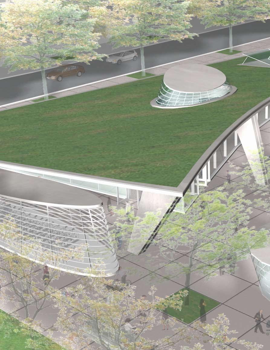
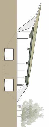
12 The report focuses on the White Flint Metrorail Station and its immediate vicinity; other planning efforts in the area have a broader scope. In 1992, the M-NCPPC, including the Montgomery County Planning Department, developed a vision for the White Flint area as part of its North Bethesda Sector Plan. White Flint Metrorail Station Today The White Flint Station is in a mixed urban/suburban setting, with a variety of strip malls, high-density condominiums, and offices within mile of the station. The station property includes a 1,270-space parking garage for use by Metro customers on a 32-acre Metro site, the majority of which has been leased to the LCOR Development Group on a long-term lease. The LCOR development, North Bethesda Center, is currently under construction and includes plans for 1.2 million square feet of office space, 1,368 residential units, and 200,000 square feet of retail. LCOR s lease includes the area immediately to the east of the station. The White Flint Metrorail station carried an average of approximately 8,500 passengers per weekday in Ridership during the peak periods is generally balanced, with only slightly more riders boarding at the station than alighting. The majority of riders are accessing the station in the morning by walking (42 percent) or driving and parking (32 percent). In the evening peak period, most riders (80 percent) access the station by walking. This indicates that while in the morning most riders either walk or drive from home to get to the station; in the evening most riders walk from their places of employment to the station. The station has adequate capacity to handle current passenger volumes. White Flint Metrorail Station in the Future The North Bethesda area is growing very quickly, as it has become a new center of condominium and apartment development along the Metrorail Red Line. Between 2000 and 2030, households within the White Flint station area are projected to grow 480 percent, and employment is expected to nearly double. There is a projected threefold increase in Metrorail ridership at the White Flint station in the 12 year period between 2008 and By 2020, over 17,000 passengers per weekday are anticipated to pass through the station. To address the study goal of increasing access to the station and adding a second station entrance, several improvements were developed: Improvement 1, the upgrade of the existing entrance, includes modifications to the existing entrance to provide an enhanced arrival experience. The existing entrance would be reconfigured to create openings on the west and east sides, a landscaped plaza, a new bicycle storage area, and one additional faregate. Figure ES-2: Improvement 2B North Entrance Improvement 2 is the construction of a new north entrance above the existing service rooms at the northern end of the plaza. Two sub-alternatives are provided, one a virtual architectural copy of the southern entrance (2A), and one an architecturally distinct entrance with a sloping green roof (2B). In either scenario, the new entrance would include a secure bicycle storage area, standard station facilities, and new service rooms. The area around the new entrance would be landscaped, and new crosswalks would be provided across Rockville Pike and Old Georgetown Road. Figure ES-2 shows Improvement 2B. Improvement 3 provides three subalternatives to crossing Rockville Pike: a short pedestrian tunnel under Rockville Pike to the west (3A), a longer pedestrian tunnel diagonally across the intersection to the northwest (3B), or a pedestrian bridge directly across Rockville Pike (3C). All alternatives would be accessible from street level via elevator, escalator, or stairs at each end. Though the new bridge or tunnel would be most practical if built in conjunction with Improvements 2A or 2B, its configuration is physically independent from the new entrance. This improvement may not be needed ES-2 Executive Summary
13 if improvements to Rockville Pike are made to enhance the pedestrian environment. Evaluation of Improvement Alternatives The improvements were analyzed to assess station capacity in the future according to Metro standards and capacity criteria. The current infrastructure at the White Flint station is generally sufficient to handle expected loads in 2020; however, the addition of a new northern entrance would dramatically improve the egress time of the station and expand the stations walkshed to more than 800 additional riders. Table ES-1 compares the potential improvements with respect to evaluation criteria derived from study goals. Evaluation criteria are reported on a relative scale and are meant for qualitative comparison only. While Improvements 2A and 2B are costly, they would increase Metro s convenience by providing more access points. They could also generate an increase in Metrorail riders, primarily due to the expanded capture area of walkers. Both improvements would substantially decrease emergency evacuation time from the station because they provide another exit point. Though 2A and 2B would provide access benefits, developers and residents expressed a preference for Improvement 2B, with its architecturally distinct features and green elements, at stakeholder meetings. As the private sector would likely finance a significant portion of the improvements at the White Flint station, this is a key factor. Improvement 1 would provide some benefit at a lower cost. It would increase the convenience of Metro by creating additional openings at the existing station entrance that align with some pedestrian and bicycle traffic. Because it would open up the station entrance to the east and create a new plaza, it would also be an attractive change for LCOR, who is developing the joint development site to the east. All of the Improvement 3 variations would increase pedestrian safety by completely separating pedestrian and vehicular traffic, reducing the chance for conflict. They would also provide some increased convenience for transit riders by eliminating the need to wait at the Old Georgetown Road intersection, which has a long traffic signal cycle length. Improvement 3B, the diagonal pedestrian tunnel, could be more attractive to developers because it would provide more direct access to the Mid-Pike Plaza, which is to be significantly redeveloped. However, it is a costly improvement. One of Metro s roles as regional agency is to study station access alternatives and evaluate their effectiveness. Metro is strongly supportive of transit improvements. The decision about whether to modify the White Flint station and/or which Improvement(s) to construct will be a collaborative one between Metro, MDOT, Montgomery County, area landowners, and other stakeholders. As part of that process, those groups would determine which improvement is most desirable and feasible. As discussed, all improvements would provide benefits related to the study goals to varying degrees. Table ES-1: Evaluation of Improvement Alternatives Evaluation Criteria Increase convenience of Metrorail Executive Summary 1 (Upgrade to Existing Station) 2A (New Standard Entrance) 2B (New Enhanced Entrance) Improvement 3A (Pedestrian Tunnel) 3B (Diagonal Pedestrian Tunnel) 3C (Pedestrian Bridge) somewhat yes yes somewhat somewhat somewhat Increase Metrorail riders no yes yes no no no Increase pedestrian safety no no no yes yes yes Increase attractiveness to developers and residents Decrease emergency evacuation time Estimated project cost FY08$(M)* somewhat yes yes no somewhat no no yes yes no no no * Estimates include construction, planning, engineering, construction management, and administrative costs and are order of magnitude in scale for planning purposes only. ES-3

14

15 Introduction Project Purpose and Scope White Flint Station Access Plan Section 1
16
17 Introduction In early 2008, the Washington Metropolitan Area Transit Authority (Metro) retained P2D, a joint venture of Parsons Transportation Group, Parsons Brinckerhoff, and Delon Hampton & Associates, to evaluate the demand for a second entrance at the White Flint Metrorail Station. This report is a culmination of those efforts. The report focuses on the White Flint Metrorail Station and its immediate vicinity, given that other planning efforts in the area address the broader station area. In 1992, the Maryland- National Capital Park and Planning Commission (M-NCPPC), including the Montgomery County Planning Department, developed a vision for the White Flint area as part of its North Bethesda Sector Plan. In 2006, the M-NCPPC began a multi-year process of developing a new Sector Plan specifically for the White Flint area. The community vision for the White Flint station is a vibrant, pedestrian-friendly area with ample green space, and a variety of housing, offices, restaurants, and shops. Figure 2: White Flint and Surrounding Stations Source: Metro Rockville Pike Georgia Avenue Veirs Mill Road Randolph Road I-270 1/2 Mile Connecticut Avenue I mile Figure 1: White Flint Vicinity Section 1 1

18 Project Purpose and Scope The White Flint Station is in a mixed urban/suburban setting, with a variety of strip malls, high-density condominiums, and offices within ½ mile of the station. The station property includes a 1,270-space parking garage for use by Metro customers on a 32-acre site, the majority of which has been leased to the LCOR Development Group on a long-term lease. The LCOR development, North Bethesda Center, is currently under construction and includes plans for 930,000 square feet of office space, 202,000 square feet of retail space (including a 62,500 square-foot grocery store), and 1,275 residential units. LCOR s lease includes the area immediately to the east of the station. The plan for joint development and adjacent development along Rockville Pike has generated interest in a second station entrance at the north end of the platform. With the recent amount of redevelopment in the White Flint area in the past decade, there has also been interest in improving pedestrian, bicycle, and transit access. The purpose of this project is to identify and evaluate options that will improve station accessibility and to evaluate the feasibility of a second station entrance. The scope of the project includes: the identification of planning goals with internal and external stakeholders; the determination of potential access improvements that can address these goals; the evaluation of bus, pedestrian, and bicycle access improvements; the generation of access improvement options; the development of preliminary designs for a second entrance; and ongoing communication and outreach with LCOR, key leaders and stakeholders, and the White Flint community. Metro coordinated with M-NCPPC and LCOR during the course of this study. The study team participated in public and stakeholder meetings held by M-NCPPC and the North Bethesda Transportation Center. These meetings provided information on potential station improvement alternatives and provided stakeholders with an opportunity to help shape the alternatives. Figure 3: Existing Development North of White Flint Station 2 Section 1
19 Section 1 3

20

21 Existing Station Characteristics Existing Station Area Land Use Existing Ridership Existing Access White Flint Station Access Plan Section 2
22 6 Section 2

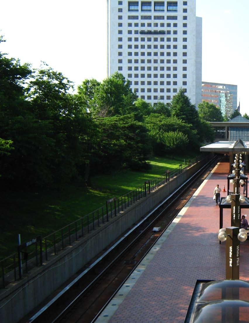
23 Existing Station Characteristics The White Flint Metrorail Station is located on the Metrorail Red Line in Rockville, Maryland. The station has a single entrance at the south end of the platform, which is at the northeast corner of Rockville Pike and Marinelli Road. The entrance is also accessible from the northwest corner of the intersection via a pedestrian tunnel. The station has a center platform and although it is not underground, it is in a trench below the grade of surrounding ground. Existing Station Area Land Use The White Flint Metrorail station is surrounded by medium to highdensity residential buildings, office buildings, and retail development. From the station, the headquarters of the U.S. Nuclear Regulatory Commission is across Marinelli Road, a Marriott hotel and the Bethesda North Conference Center are located across Rockville Pike on Marinelli Road. Metro s Park & Ride garage is located east of the station along Marinelli Road. Other key buildings include the White Flint shopping mall, located more than ½ mile south of the station, and the Mid-Pike Plaza, a strip shopping center directly northwest of the station. Much of the newer development in the area has been apartments and condominiums that advertise proximity to the Metro station. The site immediately east of the station is owned by Metro and is undergoing large-scale mixed-use joint development as part of a long-term lease with LCOR. The first phase Figure 4: First Phase of Development of this development was recently completed and includes a high-rise apartment building with a Harris Teeter grocery store in the ground floor, an underground parking structure, and a small surface parking lot. Existing Ridership The White Flint Metrorail station carried an average of approximately 8,000 passengers per weekday in The ridership patterns are shown in Figure 7. Ridership during the peak periods is generally balanced, with only slightly more riders boarding at the station than alighting. This indicates a balance of jobs and housing in the area, as riders are both taking Metro from White Flint for other work destinations, while other riders are arriving at White Flint for work destinations in the area. Since 2007 on, daily ridership has grown over six percent. Compared to other stations along the Red Line in Montgomery County, White Flint has a lower overall number of boarding Metrorail passengers, but a higher percentage of passengers who walk to the station. Section 2 7

24 Figure 5: White Flint Station Area Source: M-NCPPC, Metro 8 Section 2

25 Figure 6: White Flint Existing Land Use Section 2 9
26 Final Report Ridership data collected from Metro shows that the existing peak hours are 7:30-8:30 a.m. and 5:00-6:00 p.m.; similarly, peak half hours are 7:30-8:00 a.m. and 5:00-5:30 p.m. Park & Ride Metro opened a 1,270 space parking garage located just east of the station along Marinelli Road in October As of January 2010, the average weekday utilization rate was 48 percent. This is the lowest utilized garage in the Metrorail system, and significantly less utilized than its neighbors. The low utilization is due to the Red Line turn-backs at Grosvenor; during peak periods, half of the Red Line trains travel between Grosvenor and Silver Spring only, missing White Flint. Passengers destined for locations to the south would be more inclined to park at Grosvenor to take advantage of the double train frequency. Existing Access Most riders accessing the station in the morning walk (42 percent) or drive and park (32 percent). In the evening peak period, most riders (80 percent) access the station by walking. This indicates that morning riders most often walk or drive from home to get to the station, while evening riders mostly walk from their places of employment to the station Boardings 275 Alightings 250 Passengers Signage at the White Flint station is misleading and outdated, as a large Kiss & Ride sign points to the side of the new parking garage. However, information on Metro s website labels the small parking lot as a Kiss & Ride lot. Kiss & Ride access to the station is severely limited, as it is necessary to either double-park or violate the posted curbside traffic signage in front of the station entrance to pick up or drop off a passenger. In addition to the safety issues that this presents, customers are frequently ticketed, leading to customer dissatisfaction. Any future station plan should include legal and convenient Kiss & Ride access. Station Bus Service AM AM 3: 00 AM 1: 30 PM 12 :0 0 PM 10 :3 0 9: 00 PM PM 7: 30 PM 6: 00 PM 4: 30 PM 3: 00 PM 1: 30 AM 12 :0 0 AM 10 :3 0 AM 9: 00 AM 7: 30 6: 00 AM 0 4: 30 By 2020, Metro plans to run Red Line trains from Shady Grove to Glenmont every 2.5 minutes. When this service change occurs, the White Flint Park & Ride will have capacity to accommodate more customers. Time at start of half-hour period A relatively low percentage of passengers arrive at the station by bus. As shown in Figure 5, Metrobus route C8 and Ride On routes 5, 26, 38, 46, and 81 serve the White Flint station. The Metrobus line serves north-south traffic, whereas the Ride On routes primarily serve east-west neighborhood traffic. Figure 7: Boardings and Alightings at White Flint Station, 2007 There are four bus bays located along Rockville Pike serving these six routes at the station. The peak- Source: Metro faregate data, 2007 Table 1: Average Weekday Ridership at White Flint Station Time Period Boardings Alightings Total AM peak half hour 7:30-8:00 AM AM peak hour 7:30-8:30 AM ,038 PM peak half hour 5:00-5:30 PM PM peak hour 5:00-6:00 PM Source: Metro faregate data, 2007 Figure 8: Station Bus Routes 10 Section 2


27 Table 2: White Flint Station Access Modes, 2007 Time Period Total Metrobus Ride On Other Bus Drive Car Rode w/ Someone, parked Pick Up/Drop Off Bicycle Walk Taxi AM peak 1, percentage - 2.7% 7.7% 1.0% 31.5% 1.4% 12.1% 1.0% 42.0% 0.3% PM peak 1, ,218 0 percentage - 1.8% 9.9% 0.0% 3.5% 0.0% 2.4% 0.0% 80.1% 0.0% Source: Metro 2007 Metrorail Passenger Survey Note: AM Peak period from 5:30-9:00, PM Peak period 3:30-7:00 period headways for these routes range between 10 to 30 minutes. Bus access to the station is highest in the PM peak period. The Montgomery County Division Metrobus garage is located just east of the station along Marinelli Road. In addition to Ride On and Metrobus service, several private shuttles serve the station but lack convenient pick-up and drop-off locations. Number of People AM Peak PM Peak Pedestrian and Bicycle Facilities The sidewalks leading to the station vary in width and condition. Along the west side of the station, the sidewalk along Rockville Pike is narrow, particularly towards Old Georgetown Road where many people live. Some of the grade crossings of Rockville Pike are not pedestrian-friendly, particularly at Old Georgetown Road where there are free-flow right-turn lanes Metrobus RideOn bus Other bus Drove & parked Rode with someone, parked Mode of Access Kiss and Ride Figure 9: White Flint Station Peak Period Access Modes, 2007 Source: Metro 2007 Metrorail Passenger Survey Bike Walk Taxi The pedestrian tunnel crossing Rockville Pike is maintained by Metro. On a recent site visit, nearly all pedestrians crossing Rockville Pike used the pedestrian tunnel to avoid waiting for a traffic signal. The tunnel consists of a lighted walkway, with a stair and escalator on each side of the road. Figure 11: Pedestrian Tunnel There are 26 bike racks and 18 were found to be utilized during a site visit in There are also 20 bike lockers, of which nine were found to Figure 10: Free-Flow Right-Turn Lane at Old Georgetown Road Figure 12: Station Bicycle Racks Section 2 11


28 be utilized. The resulting 69 percent utilization rate for bike racks and 45 percent utilization rate for bike lockers indicate an adequate supply of bicycle amenities currently, and a need to promote cycling as a way to get to the station. Station Visibility M-NCPPC is currently updating the White Flint Sector Plan. As part of those efforts, they have identified the need to enhance the arrival experience at the station. There are several existing issues related to visibility: There is no Metro pylon to identify the White Flint station. The entrance is oriented towards Marinelli Road, while the majority of the pedestrians arrive from other directions. Figure 13: Landscaping at Entrance Landscaping southeast of the station visually obscures the entrance from those arriving via Metrobus or Park & Ride on Marinelli Road, as seen in Figure 13. Circulation and Capacity The White Flint Metrorail station has adequate capacity for present ridership. The station has four faregates, one ADA faregate, two exitfare machines, four fare vendors, and one SmarTrip reload station, as seen in Figure 14. The station has two escalators and one elevator connecting the platform and mezzanine, while the adjacent pedestrian tunnel has an escalator -and-stair pair at each end. Figure 14: Fare Vendors and SmarTrip Reload Station 12 Section 2
29 Section 2 13

30

31 Future Station Characteristics Future Land Use New Transportation Facilities Future Ridership White Flint Station Access Plan Section 3
32 16 Section 3

33 Future Station Characteristics Future Land Use As envisioned by the community, planners, and developers, the White Flint area will become significantly more urban over the next 10 to 15 years. The amount of development occurring near the Metrorail station was the impetus for this study. New residential, office, and retail development in the area has outpaced even recent projections, and the North Bethesda area has become a node of development in the region. In 2001, Metro chose LCOR as its joint developer partner and entered into a long-term lease for the 32 acres of property surrounding the White Flint Metrorail station. This was the largest-scale joint development project that Metro had undertaken. LCOR s plan for the site, shown in Figure 15, included 930,000 square feet of office space, 202,000 square feet of retail space (including a 62,500 square-foot grocery store), and 1,275 residential units. The first phase of development was completed in May Once completed, the development is expected to bring an additional 6,500 daily riders to the Metrorail system. The LCOR development is only one part of the large-scale development happening in White Flint. According to an October 2009 Washington Post article: White Flint is being designed to become the most densely populated new town on the Pike and a major center for new office space. Current proposals show the 420- acre area overshadowing downtown Bethesda and Rockville Town Center and dwarfing plans for Shady Grove and Twinbrook. In addition to continuing residential, office, and retail development, this area is establishing itself as a conference destination with the opening of the White Flint Conference Center and Bethesda Marriott North. There is the potential for even greater development at the Mid-Pike Plaza site, which is a 17-acre site that has proposed 1,400 new residential units, 560,000 square feet of office, 600,000 square feet of retail, and 5,270 parking spaces. That plan has yet to be heard Figure 15: Future Build-out East of White Flint Station Source: LCOR Section 3 17

34 by the Montgomery County Board, but construction is scheduled to begin in In 2008, a group of local property owners joined together to form the White Flint Partnership. This organization aims to work together to help transform the White Flint area into an accessible, engaging, and vibrant community. The Partnership has encouraged the replacement of Rockville Pike with a 21st Century Boulevard that is lined with outdoor cafes and shops, with easy access to parks and open spaces throughout the area. This group has hired a consultant and submitted a proposal for the redevelopment of Rockville Pike to counter the one submitted by M-NCPPC staff. The Planning Board is currently reviewing both proposals and will decide on a preferred alternative once a Bus Rapid Transit study is complete in To set a vision and framework for future development, the County has recently revised the White Flint Sector Plan; it is currently being reviewed by the Montgomery County Council. The 1992 Plan envisioned the White Flint area as the main urban center of North Bethesda, with mixed-use development surrounding the Metro station, including a conference center, new offices, and additional residential development. Today, much of this has been realized, with the Marriott Hotel and White Flint Conference Center, a strong base of employment along Wilkins Avenue and Executive Boulevard, and condominium development near the Metro station at Marinelli Road, Nicholson Lane, and Old Georgetown Road. In order to develop ridership projections to design and assess future station enhancements, this project developed future population projections for White Flint. Two sources were used: Metropolitan Washington Council of Governments (MWCOG) and M-NCPPC data. MWCOG land use forecasts, the industry standard for long-range planning, were used as a preliminary basis for assessing the rate of population growth in the area. To capture the most up-to-date and rapid growth in the White Flint area, data from M-NCPPC was used to develop final population projections. Table 3 shows the MWCOG Round 7 projected number of households and jobs within one-quarter and one-half mile of the White Flint Metrorail station. Growth is projected to occur most intensely at areas closest to the Metro station, and households are projected to grow more quickly than jobs in the area. As the area is more office-dominated today, the growth in residential development will help to balance the jobs to housing ratio in the station area. Figure 16: Residential Developments near White Flint Station by 2020 As part of the White Flint Sector Plan planning process, M-NCPPC updated household projections to take into account the recent upsurge in residential development in the White Flint area. Using 2008 as a base year, household projections were developed through 2020 (build out) for the White Flint station area (1/2 mile radius from the existing and proposed station entrances). Households are projected to grow more than threefold by 2020 to nearly 18 Section 3

35 Table 3: Household and Employment Forecasts within Walking Distance to White Flint Station Distance Households Employment from Station (miles) Total Change Total Change ,925 3, % 3,344 4,571 5,824 6, % ,128 2,154 4,022 6, % 13,239 15,398 18,657 21, % Source: MWCOG Round 7 Projections 14,000. The M-NCPPC projections are significantly higher than the MWCOG Round 7 projections, with an additional 10,000 households in the station area by While MWCOG regional projections are used as the standard for planning and development purposes, the fast pace of development around White Flint station required the use of updated M-NCPPC projections for this study. The M-NCPPC household projections indicate that the White Flint station area will become more residential in nature, with an increase of 9,000 housing units over the next twelve years. This will swing the jobs-tohousing ratio in favor of housing by a significant margin. The joint development site, North Bethesda Center at White Flint Metrorail (North Bethesda Center), will substantially change land use at the station site. While some phases of construction are completed, there are several more to go, including the parcels closest to the station. At the north end of the platform, a hotel and above-ground parking structure are planned. At the south end, just east of the existing entrance, office buildings are planned. The residential development is situated at the east end of the site, and retail is located throughout. New Transportation Facilities As part of the North Bethesda Center development and the Master Plan Update, new roadways are planned for the station area. A new roadway would run parallel to and east of Rockville Pike, connecting Old Georgetown and Marinelli Roads. This roadway and development along it would have front door access to the station. The Ride On bus routes that serve the station would use new bus bays along this road, relocating from Rockville Pike; however, Metrobus would stay on Rockville Pike. Another new roadway is proposed to run eastwest and bisect the site, connecting to Rockville Pike. To make this connection, it would span over the existing platform with a bridge. County planners, officials, and developers have proposed transforming Rockville Pike from a suburban arterial to a pedestrianfriendly boulevard. Because this vision is in the early stages of the planning process, a configuration has not been finalized. However, the reconstructed roadway, if studied and approved by the Maryland State Highway Administration (SHA), would likely include a wide median, wider sidewalks, landscaping, three lanes of through traffic in each direction, and turn lanes at most Figure 17: BRT System in the Vision for Rockville Pike Source: White Flint Partnership Section 3 19
36 intersections. Recently, some have proposed using median space to run bus rapid transit (BRT) service along Rockville Pike, as shown in Figure 17. In any proposed configuration, SHA would have to acquire right-of-way from at least one side of Rockville Pike. The widening of Rockville Pike to the east would need to be coordinated with Metro to ensure that adequate bus, pedestrian, and bike access to the station is maintained or enhanced. Future Ridership This study developed future ridership estimates based on 2030 ridership projections from the Metrorail Station Access and Capacity Study as well as M-NCPPC land use projections. The 2030 ridership numbers were modified to account for the surge in residential development projected in the 2008 M-NCPPC study. Ridership Projections As part of the Metrorail Station Access and Capacity Study, ridership in 2030 was forecasted at all Metrorail stations using the MWCOG Round 7 regional model as a base. The M-NCPPC projections are a more accurate and up-to-date set of household projections for the White Flint area, and therefore are the basis of the ridership projections in this study. Using Table 3 as a basis for existing boardings and alightings, Table 4 shows projected ridership for the White Flint station in 2020, based on the M-NCPPC projections. Figure 18 represents the projected growth in White Flint station combined boardings and alightings between 2007 and While population in the surrounding area is projected to grow threefold, the projected ridership at the station would approximately double between 20,000 17,500 15,000 12,500 10,000 7,500 5,000 2, ,988 17,117 2, , Daily AM Peak Hour PM Peak Hour Figure 18: Combined Boardings and Alightings at White Flint Station, 2007 and and The majority of this increase is due to the new housing facilities being built within walking distance of the White Flint station. Other Ridership Growth The preceding population projections and calculations represent only the housing units created within ½ mile of the White Flint Metrorail station. A standard ridership rate per household was established using existing ridership data, and the projected households were factored by that number to establish an estimated ridership number for build out in The ridership figures in Table 4 do not represent population growth in other parts of Montgomery County or elsewhere in Maryland. While outlying areas may continue to grow, causing more commuters to drive to the White Flint station and park before boarding a train, the preceding estimates are based on a general projected rate of increase. There are preliminary plans to establish a MARC Train station along the CSX tracks, approximately 1/2 mile from the White Flint Metrorail 2,036 Table 4: Ridership Estimates using M-NCPPC Household Projections Period Entries Exits 2007 Daily 3,976 4,022 AM Peak Hour PM Peak Hour Daily 8,509 8,608 AM Peak Hour 1,190 1,032 PM Peak Hour 1, Source: Metro station. These plans are still at a conceptual level, and while endorsed by the M-NCPPC, would most likely not be realized until after the planning horizon of If and when the MARC train service gets established in the White Flint area, the number of passengers transferring to/from the Metrorail station would most likely increase. 20 Section 3
37 Section 3 21
38

39 Station Improvement Alternatives Capacity Analysis of Alternatives NFPA 130 Emergency Egress Analysis Evaluation of Alternatives White Flint Station Access Plan Section 4
40 24 Section 4


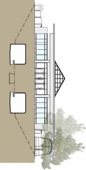
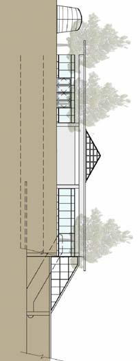
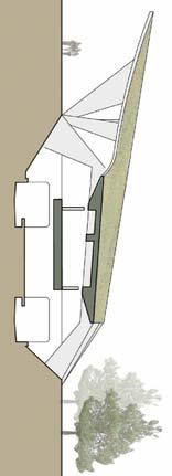
41 Station Improvement Alternatives Based on the station configuration and the land use and ridership analysis, this study explored several physical improvements aimed at enhancing access to the White Flint Station. Improvement 1 is an architectural upgrade of the existing entrance at the southern end of the platform to re-orient it to the primary direction of pedestrian flow. The existing entrance would be reconfigured by adding new entrance points on the west and east side. Bike facilities, shrubs, and fences would be moved to create a plaza. Improvement 2 is a new station entrance to be constructed above the tunnels and existing service rooms at the northern end of the platform. A second entrance would increase the station s capacity to handle passenger entrance and egress smoothly, and would expand the walkshed of the station. There are two options associated with this improvement. 2A calls for an entrance structure similar in style to the existing entrance. 2B calls for an architecturally distinctive design incorporating a green roof that would extend over both the platform and the new mezzanine. Figure 19: Improvement 1 Existing Entrance Upgrade Figure 20: Improvement 2B New North Entrance Section 4 25
42 Improvement 3 incorporates three different options for providing safer pedestrian crossings of Rockville Pike. 3A includes a pedestrian tunnel connecting the new northern entrance to the southwest corner of Rockville Pike and Old Georgetown Road. 3B involves a similar but longer diagonal tunnel connecting the station entrance with the northwest corner of Rockville Pike and Old Georgetown Road, where the Mid-Pike Plaza will be redeveloped. 3C involves a pedestrian bridge over Rockville Pike on the same alignment as 3A. These improvements may be implemented singularly or in a variety of combinations. Improvement 1 could be implemented with or without any of the other improvements, as could either of the Improvement 2 options. Although the Improvement 3 options would only be justified in conjunction with one of the Improvement 2 options, as there is already a pedestrian tunnel under Rockville Pike at Marinelli Road, its configuration is physically independent from the new entrance. Improvement 3 may not be needed if improvements to Rockville Pike are made to enhance the pedestrian environment. Capacity Analysis of Alternatives Infrastructure requirements at each entrance to the White Flint station were evaluated based on existing and projected ridership levels and requirements set by Metro and the Transit Capacity and Quality of Service Manual. The analysis established the required vertical and horizontal circulation elements. The expected conditions for 2020 were evaluated with or without a new entrance. Table 6: Summary of Station Elements at Existing Entrance Regular faregates 4 ADA faregates 1 Exitfare 2 Fare vendors 4 Platform width (feet) 27 Platform length (feet) 600 Platform elevators 1 Mezzanine elevators N/A Platform escalators 2 Mezzanine escalators N/A Platform stairs 0 Mezzanine stairs N/A Source: Metro Faregate Inventory, 2005; Metro Elevator and Escalator Inventory, 2003 For the purpose of this analysis, the infrastructure requirements for the existing (southern) entrance were considered to be the same whether or not Improvement 1 is implemented. Likewise, both of the Improvement 2 options were considered to be the same in terms of their circulation needs, and the requirements for the northern entrance were assumed to be the same whether or not a pedestrian crossing of Rockville Pike is constructed. The capacity analyses of the entrances focused on farecard vendors, faregate aisles, escalators, stairways, and the station platform. All station elements were analyzed for the peak 15-minute passenger volume. The design criteria used in the capacity analyses are summarized in Table 5. Other assumptions used in the analysis include a build year of 2020 and future peak period Metrorail service consisting of eight-car trains at 2.5-minute headways. The capacity analysis also assumed that one escalator (at the existing south entrance) was out of service at all times, because observations indicate that the most serious capacity issues occur at these times. According to the Transit Capacity and Quality of Service Manual, the flow rate for a stopped escalator is slightly higher than that of a set of stairs, or 1.59 people per feet per minute. Table 5: Assumed Metrorail Station Capacity Criteria Item Value Units Source Peaking factor for alighting passengers 1.28 Metro Escalator flow rate 90 p/min Metro, Station Access and Capacity Study Stopped escalator flow rate 19 p/ft/min Transit Capacity and Quality of Service Manual Stairway flow rate per width 10 p/ft/min Transit Capacity and Quality of Service Manual Passengers using farecard vendor 20 % PB, field measurements Farecard vendor transactions rate 2.5 p/min Bi-County Transitway, Bethesda Station Access Dem. Analysis Faregate aisle flow rate 35 p/min Metro, field measurements * Persons per foot of pathway width per minute 26 Section 4
43 Table 7 summarizes the station infrastructure requirements for the future scenarios analyzed. The station s five existing faregates are more than adequate to handle the existing and future flow of passengers. However, Improvement 1 includes an additional faregate to help the limited queuing space between the escalators, elevator, and faregates. The capacity analysis shows that, even with one stopped escalator, the existing vertical circulation elements are sufficient to meet future demand. NFPA 130 Emergency Egress Analysis The egress capacity of the existing and future conditions of the station was analyzed based on the requirements set by the National Fire Protection Association s (NFPA) Standard of Fixed Guideway Transit and Passenger Rail Systems 2007 (NFPA 130). Table 7: Infrastructure Requirement Summary Infrastructure Element Vertical Circulation (Mezzanine to Platform) Table 8: Emergency Egress Analysis Results NFPA 130 Measure Existing (2007) Number of Elements Required (2020) With improved South Entr. (Improv. 1)* No Build (2020) With Northern Entrance (Improvement 2) South AM Peak W/ Impr. 1 (2020) W/ Impr. 2 (2020) Time to clear platform (min.) Evacuation time (min.) PM Peak North Escalators Stairs 0 0 1(4 ) Farecard vendors Faregate aisles Standard ADA Total *Note: Although five faregates are required, six are proposed for enhanced circulation. Time to clear platform (min.) Evacuation time (min.) Note: Metro plans to double the Red Line frequency north of Grosvenor station by NFPA 130 requires that, under the worse-case scenario, station platforms in new transit facilities can be evacuated in four minutes and that passengers can reach a point of safety in six minutes. As this study does not propose an entirely new transit facility, Metro is not required to meet NFPA 130 exiting times, but can use them as design goals. In addition, the NFPA 130 times can be used to compare the current and future ridership exiting times, and ensure the station exiting times for future ridership to not exceed the exiting times of the current ridership. The analysis results show that the construction of the new north entrance would substantially improve the emergency egress time of the station, though emergency egress time improves across the board in the future because of more frequent Red line service. As shown in Table 8, both the time to clear the platform and the time to evacuate the station are lowest if Improvement 2 is included. Although the addition of a northern station entrance would not make the station comply with the NFPA 130 requirement for clearing the platform, the new entrance would ensure passengers egress to a point of safety in less than six minutes. Also, comparing the egress time between the no-build scenario and a scenario including only Improvement 1, it can be observed that the modifications on the existing southern entrance would not improve the emergency egress time of the station. Metro should also address emergency evacuation details other than NFPA 130, such as coordination with emergency responders, as this project progresses through the design stage. Evaluation of Alternatives Table 9 compares the potential improvements with respect to evaluation criteria derived from study goals. Evaluation criteria are reported on a relative scale and are meant for qualitative comparison only. While Improvements 2A and 2B are the costliest, they would increase the convenience of Metro by providing more access points. They could also generate an increase in Metrorail riders, primarily due to the expanded capture area of walkers. Both improvements would substantially decrease emergency evacuation time from the station because they provide another egress point. Though both 2A and 2B would provide access benefits, developers and residents expressed a Section 4 27
44 Table 9: Evaluation of Improvement Alternatives Evaluation Criteria Increase convenience of Metrorail 1 (Upgrade to Existing Station) 2A (New Entrance, Similar Style) 2B (New Entrance, New Style) Improvement 3A (Pedestrian Tunnel) 3B (Diagonal Pedestrian Tunnel) 3C (Pedestrian Bridge) somewhat yes yes somewhat somewhat somewhat Increase Metrorail riders no yes yes no no no Increase pedestrian safety no no no yes yes yes Increase attractiveness to developers and residents Decrease emergency evacuation time Estimated project cost FY08$(M)* somewhat yes yes no somewhat no no yes yes no no no * Estimates include construction, planning, engineering, construction management, and administrative costs and are order of magnitude in scale for planning purposes only. preference for Improvement 2B, with its architecturally distinct features and green elements, at stakeholder meetings. Because the private sector would likely finance a significant portion of the improvements at the White Flint station, this is a key factor. Improvement 1 would provide some benefit at a lower cost. It would increase the convenience of Metro by creating additional openings at the existing station entrance that align with some pedestrian and bicycle traffic. Because it would open up the station entrance to the east and create a new plaza, it would also be an attractive change for LCOR, who is developing the joint development site to the east. All of the Improvement 3 variations would increase pedestrian safety by completely separating pedestrian and vehicular traffic, reducing the chance for conflict. They would also provide some increased convenience for transit riders by eliminating the need to wait at the Old Georgetown Road intersection, which has a long traffic signal cycle length. Improvement 3B, the diagonal pedestrian tunnel, could be more attractive to developers because it would provide more direct access to the Mid-Pike Plaza, which is to be significantly redeveloped. However, it is a costly improvement. The decision about a grade-separated crossing should be made in the context of proposed enhancements to Rockville Pike, including transforming the Pike into a more pedestrian-friendly boulevard. One of Metro s roles as regional agency is to study station access alternatives and evaluate their effectiveness. Metro is strongly supportive of transit improvements. The decision about whether to modify the White Flint station and/or which Improvement(s) to construct will be a collaborative one between Metro, MDOT, Montgomery County, area landowners, and other stakeholders. As part of that process, those groups would determine which improvement is most desirable and feasible. As discussed, all improvements would provide benefits related to the study goals to varying degrees. 28 Section 4
45 Section 4 29

46

47 Implementation Design Features Cost Estimates White Flint Station Access Plan Section 5
48 32 Section 5
49 Implementation Design Features As discussed previously, the improvements under consideration for the White Flint station comprise three major concepts: Improvement 1: Upgrade of the existing entrance at the southern end of the platform. Improvement 2: A new entrance at the north end of the platform, in either a standard configuration similar to the south entrance (2A), or an architecturally distinctive design (2B). Improvement 3: A gradeseparated pedestrian crossing of the new north entrance across Rockville Pike. This concept would be realized through one of three solutions: a tunnel directly under Rockville Pike perpendicular to the roadway (3A), a tunnel passing diagonally under the intersection of Rockville Pike and Old Georgetown Road (3B), or a bridge over Rockville Pike on the same alignment (3C). In addition to these improvements, the LCOR development plans call for a new roadway over the White Flint Station platform just north of its mid-point. Improvement 1 Architectural Details This improvement is shown on pages 34 to 36 and in Figure 18 in Section 4. The south entrance to White Flint Station would be modified to provide a more welcoming environment, to open up the entrance area for better circulation, and to improve lines of sight for safety and comfort. The existing entrance plaza would be reconfigured, moving all bike racks and lockers and removing the chain link fences and shrubbery to create a plaza with benches. A new landscape plan and paving would enhance the modified entrance and help direct pedestrian flow. Newspaper vending would also be modified. A new bicycle storage area would be constructed on the east side of the entrance structure. The storage area would provide a secure place for bicycles while providing some cover. The storage could be accessed with a key card or code for people who want to use the facility. The entrance structure would be modified by taking down the non-structural concrete walls and iron grills along the exterior and replacing them with a glass curtain wall system similar to the New York Avenue Station. The walls would not connect to the roof, but instead float below, allowing air to flow under and over the enclosure. The existing entryway would remain, but additional entrances would be added on the east and west faces in the free area. Fare machines would be relocated along the south wall. One new faregate would be added to maximize pedestrian flow through the gates and on the escalators. This arrangement allows easier passenger movement when coming from the bus stops along Rockville Pike and the new stops along Station Place (east of the entrance). Section 5 33
50 34 Section 5
51 35 Section 5


52 36 Section 5

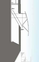
53 Structural Modifications to the existing south entrance include replacement of some of the interior non-structural walls. The modifications do not significantly change the loading on the existing structure. Mechanical There are no mechanical issues involved in this option. Electrical There are no electrical issues involved in this option. Underfloor ducts would need to be extended to the new fare gate and the relocated fare card machines. Systems System issues consist of the following: Underfloor ducts and data cables would need to be extended to the new faregate and the relocated fare card machines. Existing mezzanine closed-circuit television (CCTV) cameras may need to be relocated to coordinate with the new fare machine layout. Improvement 2 A new north entrance would be constructed above the tunnels and existing service rooms at the north end of the platform. Architectural Details The concept plans for Improvement 2A, which is architecturally similar to the existing entrance, are shown on pages 38 to 40. The concept for Improvement 2B, shown on pages 42 to 44 and in Figure 21, is to create a large precast green roofing system that will extend over both the platform and the new mezzanine. The roof would gradually slope up and over the mezzanine and create a large west facing overhang. Figure 21: Improvement 2B New North Entrance The street entrance to the mezzanine would be located on the north side, and a large overhang would cover the entry and a bicycle storage area. A large circular skylight would be located over the kiosk and gate area. The enclosure of the mezzanine would be a glass curtain wall system similar to the New York Avenue Station that floats below the ceiling and allows ample air circulation. Uplighting would be used to highlight the coffered ceiling reminiscent of the original Harry Weese Metro Stations in downtown Washington. The secured bike area would be accessible by a code or a card. A new newspaper kiosk would be located in the new west plaza area where benches, trees and landscape would provide a forecourt. The new north mezzanine would house up to six new faregates, an elongated kiosk, four fare machines, two add-fare machines, and new service rooms. The service rooms would be located along the north wall and would not be structurally connected to the roof. New vertical circulation would include an escalator/stairs pairing as well as an elevator to the platform. The elevator would open to the south on the platform level and to the north on the mezzanine level. The mezzanine would be extended over the platform to allow space for circulation between the elevator, escalator and stairs on both the mezzanine and the platform. Two or three pylons on the platform would have to be removed to make room for the new vertical circulation elements. An elevator/escalator pit would have to be created below the platform. The center of the platform would have a skylight similar to the existing canopy over the southern end of the platform. The platform would continue to have the pylons and benches, but the existing light standards would be replaced with uplighting illuminating and reflecting off the new ceiling. The area around the new entrance would be landscaped, and new crosswalks would be provided across Section 5 37
54 38 Section 5
55 39 Section 5


56 40 Section 5
57 Rockville Pike and Old Georgetown Road. Consideration should be given to modifying the intersection to remove the free right turning lanes, creating a tighter turning radius to allow easier pedestrian circulation at the corner. Structural The new north entrance would be constructed directly on top of the existing north service room area and tunnel structure. Construction of the north entrance would require structural modifications to the existing station structure, including new openings in the north service room concrete roof slab and end wall for the new elevator, escalator and stairway that provide access to the platform. The top of the north service room structure has transverse and longitudinal steps, making a leveling slab necessary to support the new north entrance floor. If the architecturally distinctive option (2B) is chosen for the north entrance, a new concrete green roof structure over the new north entrance would continue over the platform to provide a canopy that spans over the platform and tracks. The canopy would be supported by concrete columns or fins located outside of the existing structure to avoid construction on the existing platform. Though groundwater should not pose a problem during construction activities, stormwater runoff would need to be addressed during design and construction. Depending on the season, frost heave of the surficial soils would also be a concern. Mechanical The new mezzanine would house faregates, a kiosk, fare machines and new service rooms, consisting of the following: electrical room staff and public toilets cleaner s supply room elevator machine room fire equipment cabinet water service room sewage ejector room (potentially) A new elevator machine room would be required to house the mezzanine to platform elevator machinery. Based on past practice, platform to mezzanine hydraulic elevators were typically served by a machine room located below the platform. However, this configuration is discouraged by Metro criteria and would result in extensive modifications to the existing station structure beyond those required to accommodate the new elevator pit. Another available option involves the use of a remote machine room. In this case, a minimum 12 foot by 12 foot by 9 foot high space is necessary to house elevator equipment. Hydraulic piping would need to be routed between the elevator pit and the selected machine room location. Additional modifications to the existing station platform and invert structure are required to accommodate the new escalator pit. Elevator and escalator pit drainage would be provided in accordance with local building codes and environmental regulations. Sump pumps may be necessary to complete connections to the existing drainage system. Space is required to house escalator control panels. The required space would need to be sized to provide electrical code mandated clearances and be located behind a lockable door. The addition of the new escalator and elevator would also require reconfiguration of the existing fire line currently located below the platform. The new toilet and cleaner s rooms require water service. In addition, if gravity flow to the existing Washington Suburban Sanitary Commission (WSSC) sanitary system is not feasible, a sewage ejector system would also be required. The existing sewage ejector room and water service room are located at the south end of the station. However, utilizing these spaces to serve the new cleaner s room and toilets is problematic. Specifically, the resulting piping runs will exceed 600 feet in length and will also require freeze protection. A new water service room and potentially a new sewage ejector room would be required. A water service room has minimum dimensions of 6-0 by A sewage ejector room has dimensions of 16-0 by Both spaces can conceivably be combined into a single space with dimensions of 16-0 by The new electrical room, toilets, cleaner s room, water service room and sewage ejector room require heating and ventilation in accordance with Metro criteria. Air conditioning and heating would be provided for the elevator machine room. Metro criteria require ventilation for machine rooms, but not air conditioning. Air conditioning provides a more suitable environment for electronic components and a variance to criteria is warranted in this case. As is the case with the existing south mezzanine, the proposed storefront would be configured in a way that maintains natural ventilation. Mechanical ventilation is therefore not required. Section 5 41
58 42 Section 5
59 43 Section 5


60 44 Section 5
61 A new fire equipment cabinet, a new siamese connection, and a standpipe system would be required. Per Metro criteria, the siamese connection would be located near the new station entrance and within 100 feet of a vehicular access. The new siamese connection would serve an angle hose valve located in the new fire equipment cabinet, and would also be connected to the existing station platform and mezzanine fire standpipe system. Per Metro criteria, a fire hydrant would be required within 100 feet of the fire department siamese connection. The hydrant must be installed in a location that would not necessitate running fire hoses across a major or heavilytrafficked thoroughfare. The cleaner s room and the toilets require fire protection in the form a sprinkler system designed for materials storage, NFPA ordinary hazard, Group 1. Electrical New electrical circuits to provide power to lights, emergency lights and mechanical equipment would be required. Electrical distribution equipment would be required in each of the elevator machine rooms and escalator control room. Electrical circuits installed in conduit would run from the nearest source of power in the existing passenger station AC switchgear rooms. Conduits would be concealed or embedded wherever feasible. Some modifications would be required in the AC switchgear rooms such as adding new circuit breakers, evaluating the impact of adding new loads on the existing equipment, and increasing the capacity of the uninterruptible power system (UPS) where necessary. Evaluation of the existing AC switchgear at both ends would be in accordance with the latest Metro design criteria. It is a requirement that each AC switchgear room be sufficient to handle the complete station electrical load. Where necessary, the tie cable between north and south AC switchgear rooms would be replaced with one of suitable capacity. The kiosk would require both an essential and an emergency feeder from the north AC switchgear room. Systems Closed-circuit television (CCTV) cameras to monitor elevator and escalator access would be required. Conduits/cables would be required between these cameras and the corresponding communication room and new kiosk. Conduits would be concealed or embedded wherever feasible. Intrusion devices on all elevator machine rooms, escalator control access doors and service room doors would be required. Conduits/cables would be required between these devices and the corresponding communication room. Additional conduits/cable may be required to go from the communication room to the new kiosk. Fire alarm devices associated with elevator and escalator equipment would be required. Conduits/cables would be required between these devices and the corresponding communication room. Additional conduits/cable may be required to go from the communication room to the new kiosk. Passenger Information Display System (PIDS) would be required for the new mezzanine. Conduits/ cables would be required between thee display and the corresponding communication room. Public address speakers would be required in the new mezzanine. Conduits/cables would be required between the speakers and the corresponding communication room. Modifications to the existing kiosk at the south entrance would be required to accommodate additional elevators, escalators, CCTV cameras, intrusion, fire and communication equipment. The new kiosk would need to be interfaced with the existing communications room and kiosk, and would need to be configured for control of all equipment, both existing and new. Improvement 3 Rockville Pike is an exceptionally wide and busy roadway, and its current configuration discourages pedestrian traffic from its west side to the location of the proposed new station entrance. To make Rockville Pike less of a pedestrian barrier, three solutions have been proposed to allow pedestrians to cross either under or over the roadway. However, these improvements may not be needed if improvements to Rockville are made to enhance the pedestrian environment. As mentioned previously, these are a short tunnel under Rockville Pike to the west, a longer tunnel diagonally across the intersection to the northwest, or a bridge directly across Rockville Pike. All of these alternatives will be accessible from street level via elevator, escalator, or stairs at each end of the crossing. The new pedestrian tunnel or bridge structure would be independent from the new north entrance structure. These concepts are shown on pages 47 to 50. Also under consideration are atgrade modifications to the sidewalks, Section 5 45
62 lanes and medians of Rockville Pike to make the roadway less difficult to cross. These treatments would have minimal physical impacts to the station itself. Montgomery County is also considering transforming the Pike into a pedestrian-friendly boulevard, so depending on when this would be constructed, these changes might already be made. Architectural Details The tunnel options would each be designed as standard Metro passageways measuring approximately 22 feet wide. They would have a curved concrete base and ceiling, and cantilevered railings along the edge. Recessed lighting would be located in the ceilings. Drains would be provided at the bottom of the stairs and escalators to keep the tunnels from flooding during storms. The entry stairs and escalators would be covered with a standard Metro entry canopy. The bridge would have glass enclosure similar to the New York Avenue Station with space at the top and bottom for air circulation. The roof would be metal, and the structure may be a metal truss to keep the depth as shallow as possible. An elevator machine room would be located under the stairs and escalators at each end. Structural If the pedestrian tunnel under Rockville Pike was constructed using a cut-and-cover method, staged construction and temporary roadway bridging to minimize land closures would be utilized. The top of the tunnel would be located at a minimum depth below the existing roadway. Temporary shoring would be required to limit the extent of the excavation. In addition, a temporary abutment would be constructed to provide support for temporary roadway bridging. The box tunnel structure may be castin-place concrete. The use of precast concrete box sections assembled on site may reduce the construction duration considerably. Since Rockville Pike is a major traffic corridor, construction would be sequenced to minimize the impact to traffic. The 20 foot deep excavation for the pedestrian tunnel would be located completely in clay and silt soil layers. Construction of the pedestrian bridge structure will require brief closures of Rockville Pike during placement of the bridge structure. The closures may be scheduled at night to minimize disruption to traffic. The structures at each end to house the elevator and stairway would be supported by pile foundations to minimize settlement. Temporary support of utilities will be required during construction of a pedestrian crossing under or above Rockville Pike. A study should be performed to determine the location of all underground and overhead utilities, including abandoned utilities that may conflict with the new construction. Mechanical A machine room sized to serve two elevators would be required at each end of the tunnel or bridge. Required elevator machine room dimensions would be 12 feet by 18 feet by 9 feet high. Air conditioning and heating would be provided for the elevator machine rooms. Space is required to house the escalator control panels. The required space would need to be sized to provide electrical code-mandated clearances and be located behind a lockable door. A dry standpipe system would be provided in the pedestrian tunnel (Options 2 and 3) with angle hose valves located in the vicinity of each exit and an additional angle hose valve located at the approximate center of the walkway. This system would consist of an entirely separate dry standpipe system. Elevator and escalator pit drainage would be provided in accordance with local building codes and environmental regulations. Sump pumps may be necessary to complete connections to the existing drainage system. Area drains would be provided as required to serve the new pedestrian tunnels and any associated shafts. Sump pumps may be necessary to complete connections to the existing drainage system. Electrical New electrical circuits to provide power to lights, emergency lights and mechanical equipment would be required. Electrical distribution equipment would be required in each of the elevator machine rooms and the escalator control room. Systems Closed-Circuit Television (CCTV) cameras to monitor elevator and escalator access would be required. Conduits/cables would be required between these cameras and the corresponding communication room and new kiosk. Conduits would be concealed or embedded wherever feasible. Intrusion detection devices on all elevator machine rooms and escalator control access doors would be required. Conduits/cables would be required between these devices and the corresponding communication room. Additional conduits/cable may be required to go from the 46 Section 5
63 47 Section 5
64 48 Section 5
65 49 Section 5


66 50 Section 5
67 communication room to the new kiosk at the north entrance. Fire alarm devices associated with elevator and escalator equipment would be required. Conduits/cables would be required between these devices and the corresponding communication room. Additional conduits/cable may be required to go from the communication room to the new kiosk. The new kiosk at the north entrance would provide for control and indication of all new equipment and interfaced with the existing communication room and existing kiosk. Modifications to the existing kiosk at the south entrance would be required to accommodate additional elevators, escalators, CCTV cameras, intrusion, fire and communication equipment. Cost Estimates The order-of-magnitude cost estimates that were developed for each alternative are shown in Table 10. The construction cost estimates include the following: A 25 percent design contingency. This allowance is included to cover the continuing refinements to the design drawings during the evolution of the design. This contingency does not cover the owner s risk in changes, claims, and personnel costs for the project which are referred to as project delivery costs in this study. A 25 percent temporary facilities overhead, which are the costs of mobilizing and establishing the contractor s equipment and facilities necessary to complete the work of the project. They include purchase, lease, shipping, site erection of the Table 10: Order of Magnitude Cost Estimates Improvement construction equipment, work site preparation, and establishing temporary utilities, among others. A 13 percent contractor profit and overhead allowance, which is factored on the basis of the total project labor costs and reflects a judgment of the possible risk in this project. A seven percent mobilization fee, which is the amount the owner decides to offer in the bid form as an up-front repayment of a portion of the contractor s expenses. The cost estimates for Improvements 1, 2A, and 2B include a small bicycle storage facility. If the design changes to include a larger, more substantial facility, Metro will adjust the cost estimates accordingly. The cost of maintaining traffic during construction is included in the cost of Improvements 3A, 3B, and 3C, as they would include work within Rockville Pike and Old Georgetown Road. In addition, cost escalation beyond year 2008 is not included. An allowance of 35 percent was added to construction costs for project delivery; this includes additional planning, engineering, construction management, and administrative costs. Construction Cost (FY08 $) Project Cost* (FY08 $) 1: Modified Existing South Entrance 1,100,000 1,500,000 2A: New North Entrance 10,000,000 13,500,000 2B: New Enhanced North Entrance 16,500,000 22,300,000 3A: Pedestrian Tunnel at North End (Perpendicular) 8,800,000 11,900,000 3B: Pedestrian Tunnel at North End (Diagonal) 17,500,000 23,700,000 3C: Pedestrian Bridge at North End 5,000,000 6,800,000 *Includes soft costs such as planning, engineering, and construction management. Costs are order of magnitude in scale for planning purposes only. Section 5 51
68

69 References and Appendix References Analysis Details White Flint Station Access Plan
Bi-County Transitway/ Bethesda Station Access Demand Analysis
 Bi-County Transitway/ Bethesda Station Access Demand Analysis Prepared for: Washington Metropolitan Area Transit Authority Office of Planning and Project Development May 2005 Prepared by: in conjunction
Shady Grove. Station Access Improvement Study. Final Report July Washington Metropolitan Area Transit Authority
 Shady Grove Station Access Improvement Study Final Report July 2011 Washington Metropolitan Area Transit Authority Acknowledgements Washington Metropolitan Area Transit Authority Station Area Planning
NAVY YARD BALLPARK STATION ACCESS IMPROVEMENTS STUDY. Final Report. Washington Metropolitan Area Transit Authority
 NAVY YARD BALLPARK STATION ACCESS IMPROVEMENTS STUDY Final Report Washington Metropolitan Area Transit Authority Office of Real Estate and Station Planning April 2016 [This page intentionally left blank]
ANDERSON PROPERTY SITE ANALYSIS
 ANDERSON PROPERTY SITE ANALYSIS Introduction The Montgomery County Department of Transportation (MCDOT) initiated a feasibility study in the fall of 2012 to evaluate the need for transit service expansion
Maryland Gets to Work
 I-695/Leeds Avenue Interchange Reconstruction Baltimore County Reconstruction of the I-695/Leeds Avenue interchange including replacing the I-695 Inner Loop bridges over Benson Avenue, Amtrak s Northeast
TORONTO TRANSIT COMMISSION REPORT NO.
 Form Revised: February 2005 TORONTO TRANSIT COMMISSION REPORT NO. MEETING DATE: October 24, 2012 SUBJECT: DOWNTOWN RAPID TRANSIT EXPANSION STUDY (DRTES) PHASE 1 STRATEGIC PLAN ACTION ITEM RECOMMENDATIONS
CEDAR AVENUE TRANSITWAY Implementation Plan Update
 CEDAR AVENUE TRANSITWAY Implementation Plan Update EECUTIVE SUMMARY DECEMBER 2015 Executive Summary In 2013, the Twin Cities metropolitan area s first bus rapid transit (BRT) line, the METRO Red Line,
BROWARD BOULEVARD CORRIDOR TRANSIT STUDY
 BROWARD BOULEVARD CORRIDOR TRANSIT STUDY FM # 42802411201 EXECUTIVE SUMMARY July 2012 GOBROWARD Broward Boulevard Corridor Transit Study FM # 42802411201 Executive Summary Prepared For: Ms. Khalilah Ffrench,
METRO Orange Line BRT American Boulevard Station Options
 METRO Orange Line BRT American Boulevard Station Options Bloomington City Council Work Session November 18, 2013 Christina Morrison BRT/Small Starts Project Office Coordinating Planning and Design AMERICAN
Public Meeting. March 21, 2013 Mimosa Elementary School
 Public Meeting March 21, 2013 Mimosa Elementary School Today s Meeting Purpose 2 Where We Are The Process What We ve Heard and Findings Transit Technologies Station Types Break-out Session Where We Are
Presentation Overview. Stop, Station, and Terminal Capacity
 Stop, Station, and Terminal Capacity Mark Walker Parsons Brinckerhoff Presentation Overview Brief introduction to the project Station types & configurations Passenger circulation and level of service Station
FREQUENTLY ASKED QUESTIONS
 FREQUENTLY ASKED QUESTIONS 2018 What is the More MARTA Atlanta program? The More MARTA Atlanta program is a collaborative partnership between MARTA and the City of Atlanta to develop and implement a program
Downtown Lee s Summit Parking Study
 Downtown Lee s Summit Parking Study As part of the Downtown Lee s Summit Master Plan, a downtown parking and traffic study was completed by TranSystems Corporation in November 2003. The parking analysis
QUALITY OF LIFE EXECUTIVE SUMMARY REPORT I O N S TAT I O N
 QUALITY OF LIFE EXECUTIVE SUMMARY REPORT UN I O N S TAT I O N T R AV E L by TR A I N Published September 2017 2015 PROGRESS MAP This document reports FasTracks progress through 2015 BACKGROUND RTD The
5. OPPORTUNITIES AND NEXT STEPS
 5. OPPORTUNITIES AND NEXT STEPS When the METRO Green Line LRT begins operating in mid-2014, a strong emphasis will be placed on providing frequent connecting bus service with Green Line trains. Bus hours
Green Line LRT: Beltline Segment Update April 19, 2017
 Green Line LRT: Beltline Segment Update April 19, 2017 Quick Facts On April 11, 2017, City Council approved Administration s recommendation for the Green Line to be underground in the Beltline from 2 Street
appendix 4: Parking Management Study, Phase II
 appendix 4: Parking Management Study, Phase II A4-1 A4-2 Eastlake Parking Management Study Final Phase 2 Report Future Parking Demand & Supply January 6, 2017 Submitted by Denver Corp Center III 7900 E.
Executive Summary. Treasure Valley High Capacity Transit Study Priority Corridor Phase 1 Alternatives Analysis October 13, 2009.
 Treasure Valley High Capacity Transit Study Priority Corridor Phase 1 Alternatives Analysis October 13, 2009 Background As the Treasure Valley continues to grow, high-quality transportation connections
Troost Corridor Transit Study
 Troost Corridor Transit Study May 23, 2007 Kansas City Area Transportation Authority Agenda Welcome Troost Corridor Planning Study Public participation What is MAX? Survey of Troost Riders Proposed Transit
US 29 Bus Rapid Transit Planning Board Briefing. February 16, 2017
 US 29 Bus Rapid Transit Planning Board Briefing February 16, 2017 Project Goals Improve the quality of transit service Improve mobility opportunities and choices Enhance quality of life Support master
Letter EL652 City of Mercer Island. Page 1. No comments n/a
 Letter EL652 City of Mercer Island Page 1 No comments n/a Page 2 Response to comment EL652 1 Section 4.5.3 of the Final EIS presents the range of potential impacts of the project. This project also lists
CTA Blue Line Study Area
 CTA Blue Line Study Area HISTORY OF THE CTA BLUE LINE / I-290 SYSTEM Blue Line / I-290 infrastructure is 55 years old First integrated transit / highway facility in the U.S. PROJECT STUDY AREA EXISTING
I-290 Phase I Study Summary of NFPA-130 Analysis of Proposed CTA Station Platform Widths May 2016
 I-290 Phase I Study Summary of NFPA-130 Analysis of Proposed CTA Station Platform Widths May 2016 INTRODUCTION As part of the I-290 reconstruction phase I study, IDOT has coordinated with the CTA regarding
CORE AREA SPECIFIC PLAN
 only four (A, B, D, and F) extend past Eighth Street to the north, and only Richards Boulevard leaves the Core Area to the south. This street pattern, compounded by the fact that Richards Boulevard is
EUGENE-SPRINGFIELD, OREGON EAST WEST PILOT BRT LANE TRANSIT DISTRICT
 EUGENE-SPRINGFIELD, OREGON EAST WEST PILOT BRT LANE TRANSIT DISTRICT (BRIEF) Table of Contents EUGENE-SPRINGFIELD, OREGON (USA)... 1 COUNTY CONTEXT AND SYSTEM DESCRIPTION... 1 SYSTEM OVERVIEW... 1 PLANNING
CLRP. Performance Analysis of The Draft 2014 CLRP. Long-Range Transportation Plan For the National Capital Region
 NATIONAL CAPITAL REGION TRANSPORTATION PLANNING BOARD Item 12 CLRP Financially Constrained Long-Range Transportation Plan For the National Capital Region 2014 Performance Analysis of The Draft 2014 CLRP
Energy Technical Memorandum
 Southeast Extension Project Lincoln Station to RidgeGate Parkway Prepared for: Federal Transit Administration Prepared by: Denver Regional Transportation District May 2014 Table of Contents Page No. Chapter
King County Metro. Columbia Street Transit Priority Improvements Alternative Analysis. Downtown Southend Transit Study. May 2014.
 King County Metro Columbia Street Transit Priority Improvements Alternative Analysis Downtown Southend Transit Study May 2014 Parametrix Table of Contents Introduction... 1 Methodology... 1 Study Area...
Denver Car Share Program 2017 Program Summary
 Denver Car Share Program 2017 Program Summary Prepared for: Prepared by: Project Manager: Malinda Reese, PE Apex Design Reference No. P170271, Task Order #3 January 2018 Table of Contents 1. Introduction...
Click to edit Master title style
 Nelson/Nygaard Consulting Associates SERVICE IMPROVEMENT STRATEGIES September 22, 2015 1 PROJECT OVERVIEW & WORK TO DATE 1. Extensive stakeholder involvement Throughout 2. System and market assessment
Chevy Chase Lake. Preliminary Plan # B TRAFFIC STATEMENT. Prepared for: Chevy Chase Land Company & Bozzuto Development Company
 Chevy Chase Lake Preliminary Plan # 12002020B TRAFFIC STATEMENT Prepared for: Chevy Chase Land Company & Bozzuto Development Company Montgomery County, Maryland Prepared by: SSSTS Consulting (410) 718-8660
Executive Summary. Draft Environmental Impact Statement/Environmental Impact Report ES-1
 Executive Summary Introduction The Eastside Transit Corridor Phase 2 Project is a vital public transit infrastructure investment that would provide a transit connection to the existing Metro Gold Line
Transit Hub Case Study: Owings Mills Metro Station. By: Kathleen Cary Rose, J. Luke Byrne and Catherine Buhler
 Executive Summary Transit Hub Case Study: Owings Mills Metro Station By: Kathleen Cary Rose, J. Luke Byrne and Catherine Buhler The purpose of the Transit Hub Case Study is to identify and evaluate the
Mercer Island Center for the Arts Parking Management Plan
 Parking Stalls Mercer Island Center for the Arts Parking Management Plan June 15, 2016 This Parking Management Plan (P) covers all tenants at the Mercer Island Center for the Arts (MICA) campus, including
1 On Time Performance
 MEMORANDUM: US 29 Travel Time & OTP To: From: Joana Conklin, Montgomery County DOT James A. Bunch, SWAI Subject: US 29 Travel Time and On Time Performance Analysis Date: This memorandum documents the US
Rail alignment and benefits (rab) study
 study") Rail alignment and benefits (rab) study previously known as railyard alternatives & i-280 boulevard study June 5, 2018 CONNECTING CALIFORNIA 4,300 lane miles + 115 Airport gates would be needed to create
Rail alignment and benefits (rab) study previously known as railyard alternatives & i-280 boulevard study June 5, 2018 CONNECTING CALIFORNIA 4,300 lane miles + 115 Airport gates would be needed to create
Kendall Drive Premium Transit PD&E Study Project Kick-Off Meeting SR 94/Kendall Drive/SW 88 Street Project Development and Environment (PD&E) Study
 Study") Florida Department of Transportation District Six Kendall Drive Premium Transit PD&E Study Project Kick-Off Meeting SR 94/Kendall Drive/SW 88 Street Project Development and Environment (PD&E) Study What
Florida Department of Transportation District Six Kendall Drive Premium Transit PD&E Study Project Kick-Off Meeting SR 94/Kendall Drive/SW 88 Street Project Development and Environment (PD&E) Study What
Preliminary Definition of Alternatives. 3.0 Preliminary Definition of Alternatives
 3.0 What preliminary alternatives are being evaluated? The alternatives for the East San Fernando Valley Transit Corridor project that were considered for screening include the No Build Alternative, Transportation
West LRT. Alignment Update and Costing Report May Calgary Transit Transportation Planning Clifton ND Lea Consultants
 West LRT Alignment Update and Costing Report 2006 May Calgary Transit Transportation Planning Clifton ND Lea Consultants West LRT Update Background The service area for West LRT is generally described
Green Line Long-Term Investments
 Enhancements Short-term improvements to keep Austin moving. Investments Long-term projects to support our future. Mobility Hubs MetroRapid MetroRail MetroExpress Connectors Circulators Project Connect
Valley Metro Overview. ITE/IMSA Spring Conference March 6, 2014
 Valley Metro Overview ITE/IMSA Spring Conference March 6, 2014 Valley Metro Who Are We? Operate Regional Transit Services Valley Metro and Phoenix are region s primary service providers Light Rail and
THE WAY WE MOVE LRT FOR EVERYONE
 THE WAY WE MOVE LRT FOR EVERYONE 2 LRT for Everyone LRT FOR EVERYONE Light rail is about more than transit; it s about transforming Edmonton. As the city grows, so do its transportation needs. LRT is an
Waco Rapid Transit Corridor (RTC) Feasibility Study
 Feasibility Study") Waco Rapid Transit Corridor (RTC) Feasibility Study Chris Evilia, Director of Waco Metropolitan Planning Organization Allen Hunter, General Manager Waco Transit System Jimi Mitchell, Project Manager AECOM
Waco Rapid Transit Corridor (RTC) Feasibility Study Chris Evilia, Director of Waco Metropolitan Planning Organization Allen Hunter, General Manager Waco Transit System Jimi Mitchell, Project Manager AECOM
Attachment 5. High Speed Transit Planning Study REPORT SUMMARY. Prepared by: City of Edmonton Transportation Planning Branch. Stantec Consulting Ltd.
 Attachment 5 High Speed Transit Planning Study Prepared by: City of Edmonton Transportation Planning Branch Stantec Consulting Ltd. Transportation Management & Design, Inc. with Lea Consulting Ltd. [135-35130]
STH 60 Northern Reliever Route Feasibility Study Report
 #233087 v3 STH 60 Northern Reliever Route Feasibility Study Report Washington County Public Works Committee Meeting September 28, 2016 1 STH 60 Northern Reliever Route Feasibility Study Hartford Area Development
Northeast Corridor Alternatives Analysis. Public Involvement Round 2 Input on Alternatives for Further Study
 Northeast Corridor Alternatives Analysis Public Involvement Round 2 Input on Alternatives for Further Study Feb. 7-9, 2012 Agenda Review project background Progress summary Recommended alternatives for
7359 WISCONSIN AVENUE MONTGOMERY COUNTY, MARYLAND
 7359 WISCONSIN MONTGOMERY COUNTY, MARYLAND September 1, 2017 7359 Wisconsin Avenue September 2017 7359 WISCONSIN Local Area Transportation Review Montgomery County, Maryland September 1, 2017 Prepared
The Engineering Department recommends Council receive this report for information.
 CORPORATE REPORT NO: R161 COUNCIL DATE: July 23, 2018 REGULAR COUNCIL TO: Mayor & Council DATE: July 19, 2018 FROM: General Manager, Engineering FILE: 8740-01 SUBJECT: Surrey Long-Range Rapid Transit Vision
Project Status Update January 2017
 Project Status Update January 2017 1 What is the Purple Line? A new 16 mile east-west light rail line Operates mostly on the surface with 21 stations Connects New Carrollton in Prince George s County and
Public Meeting. City of Chicago Department of Transportation & Department of Housing and Economic Development
 Public Meeting City of Chicago Department of Transportation & Department of Housing and Economic Development Funded by Regional Transportation Authority September 12, 2011 In partnership with Presentation
Fresno County. Sustainable Communities Strategy (SCS) Public Workshop
 Public Workshop") Fresno County Sustainable Communities Strategy (SCS) Public Workshop Project Background Senate Bill 375 Regional Transportation Plan (RTP) Greenhouse gas emission reduction through integrated transportation
Fresno County Sustainable Communities Strategy (SCS) Public Workshop Project Background Senate Bill 375 Regional Transportation Plan (RTP) Greenhouse gas emission reduction through integrated transportation
Update on Bus Stop Enhancements
 Customer Service and Operations Committee Board Information Item III-A February 2, 2012 Update on Bus Stop Enhancements Page 3 of 15 Washington Metropolitan Area Transit Authority Board Action/Information
FINAL. Sound Transit Long-Range Plan Update. Issue Paper S.1: Tacoma Link Integration with Central Link. Prepared for: Sound Transit
 Sound Transit Long-Range Plan Update Issue Paper S.1: Tacoma Link Integration with Central Link Prepared for: Sound Transit Prepared by: Quade & Douglas, Inc. FINAL March 2005 Foreword This issue paper
4 Circulation & Transportation
 4.1 Mobility Network The mobility network at the new St. Paul s hospital and health campus is comprised of an interconnected system of sidewalks, cycle paths, transit routes and roadways. Figure 4-1: Indicative
MOTION NO. M Preferred Alternative for the Puyallup Station Access Improvement Project
 MOTION NO. M2014 64 Preferred Alternative for the Puyallup Station Access Improvement Project MEETING: DATE: TYPE OF ACTION: STAFF CONTACT: Capital Committee Board PROPOSED ACTION 8/14/14 8/28/14 Recommendation
Chapter 4 : THEME 2. Transportation
 Chapter 4 : THEME 2 Strengthen connections to keep the Central Area easy to reach and get around 55 Figure 4.2.1 Promote region-wide transit investments. Metra commuter rail provides service to the east,
Green Line LRT: Beltline Recommendation Frequently Asked Questions
 Green Line LRT: Beltline Recommendation Frequently Asked Questions June 2017 Quick Facts Administration has evaluated several alignment options that would connect the Green Line in the Beltline to Victoria
TRAVEL DEMAND FORECASTS
 Jiangxi Ji an Sustainable Urban Transport Project (RRP PRC 45022) TRAVEL DEMAND FORECASTS A. Introduction 1. The purpose of the travel demand forecasts is to assess the impact of the project components
Develop ground transportation improvements to make the Airport a multi-modal regional
 Project Overview TRANSPORTATION IMPROVEMENTS WHAT ARE THE PROJECT GOALS? Transportation transportation hub. Develop ground transportation improvements to make the Airport a multi-modal regional Land Use
Location Concept Plan Amendment Recommendation Approved 2011 Concept Plan
 Valley Line West LRT Concept Plan Recommended Amendments Lewis Farms LRT Terminus Site Location Concept Plan Amendment Recommendation Approved 2011 Concept Plan Lewis Farms LRT terminus site, 87 Avenue/West
SUPPORTING TOD IN METRO CHICAGO
 www.rtachicago.org SUPPORTING TOD IN METRO CHICAGO Tuesdays at APA November 18, 2014 OVERVIEW OF RTA 2 11/18/2014 Tuesdays at APA: Supporting TOD in Metro Chicago RTA Region 8.5 million people 3,700 square
Service Quality: Higher Ridership: Very Affordable: Image:
 Over the past decade, much attention has been placed on the development of Bus Rapid Transit (BRT) systems. These systems provide rail-like service, but with buses, and are typically less expensive to
GO Transit s deliverable: the 2020 Service Plan
 GO Transit s deliverable: the 2020 Service Plan GO Transit s 2020 Service Plan describes GO s commitment to customers, existing and new, to provide a dramatically expanded interregional transit option
West Broadway Transit Study. Community Advisory Committee September 17, 2015
 West Broadway Transit Study Community Advisory Committee September 17, 2015 Introductions Community Engagement Summer Outreach Fall Outreach Technical Analysis Process Update Alternatives Review Economic
Rail alignment and benefits (rab) study
 study") Rail alignment and benefits (rab) study previously known as railyard alternatives & i-280 boulevard study May 22, 2018 CONNECTING CALIFORNIA 4,300 lane miles + 115 Airport gates would be needed to create
Rail alignment and benefits (rab) study previously known as railyard alternatives & i-280 boulevard study May 22, 2018 CONNECTING CALIFORNIA 4,300 lane miles + 115 Airport gates would be needed to create
9. Downtown Transit Plan
 CORRADINO 9. Downtown Transit Plan KAT Transit Development Plan As part of the planning process for the TDP, an examination of downtown transit operations was conducted. The Downtown Transit Plan 1 is
2.4 TRANSIT VISION 2040 FROM VISION TO ACTION. Support the revitalization of urban cores STRATEGIC DIRECTION
 TRANSIT VISION 2040 FROM VISION TO ACTION TRANSIT VISION 2040 defines a future in which public transit maximizes its contribution to quality of life with benefits that support a vibrant and equitable society,
IV. ENVIRONMENTAL IMPACT ANALYSIS K.2. PARKING
 IV. ENVIRONMENTAL IMPACT ANALYSIS K.2. PARKING ENVIRONMENTAL SETTING The following analysis summarizes the findings and conclusions of the Traffic Analysis (Traffic Study), prepared by The Mobility Group,
STRATEGIC PRIORITIES AND POLICY COMMITTEE MAY 5, 2016
 STRATEGIC PRIORITIES AND POLICY COMMITTEE MAY 5, 2016 Shift Rapid Transit Initiative Largest infrastructure project in the city s history. Rapid Transit initiative will transform London s public transit
2.0 Development Driveways. Movin Out June 2017
 Movin Out June 2017 1.0 Introduction The proposed Movin Out development is a mixed use development in the northeast quadrant of the intersection of West Broadway and Fayette Avenue in the City of Madison.
Mr. Leif Dormsjo Director, District Department of Transportation 55 M Street, SE Washington, DC July 10, Dear Director Dormsjo,
 Adams Morgan BID Capitol Hill BID Capitol Riverfront BID Coalition for Smarter Growth Destination DC Downtown BID Events DC Federal City Council Georgetown BID Golden Triangle BID Greater Greater Washington
Madison BRT Transit Corridor Study Proposed BRT Operations Plans
 Madison BRT Transit Corridor Study Proposed BRT Operations Plans This paper presents a description of the proposed BRT operations plan for use in the Madison BRT Transit Corridor Study. The objective is
Address Land Use Approximate GSF
 M E M O R A N D U M To: Kara Brewton, From: Nelson\Nygaard Date: March 26, 2014 Subject: Brookline Place Shared Parking Analysis- Final Memo This memorandum presents a comparative analysis of expected
4 COSTS AND OPERATIONS
 4 COSTS AND OPERATIONS 4.1 INTRODUCTION This chapter summarizes the estimated capital and operations and maintenance (O&M) costs for the Modal and High-Speed Train (HST) Alternatives evaluated in this
Community Advisory Committee. October 5, 2015
 Community Advisory Committee October 5, 2015 1 Today s Topics Hennepin County Community Works Update Project Ridership Estimates Technical Issue #4:Golden Valley Rd and Plymouth Ave Stations Technical
CITY OF ANN ARBOR, MICHIGAN 301 E. Huron St., P.O. Box 8647 Ann Arbor, Michigan
 Date: Wednesday, June 18, 2014 Location: Ann Arbor District Library Attendees: 14 citizen attendees Ann Arbor Station Environmental Review Citizen Working Group Meeting Notes Meeting #3 The third meeting
CITY OF ANN ARBOR, MICHIGAN 301 E. Huron St., P.O. Box 8647 Ann Arbor, Michigan
 Date: Wednesday, June 24, 2014 Location: Ann Arbor District Library Attendees: 40 citizen attendees Ann Arbor Station Environmental Review Public Meeting Meeting Notes Meeting #2 The second public meeting
West Broadway Reconstruction/LRT Design. March 19, 2015
 West Broadway Reconstruction/LRT Design March 19, 2015 1 Meeting Agenda 6:05 6:30 PM Brief presentation What we heard Project overview 6:30 8:00 PM Visit Six Topic Areas Road and LRT design elements Pedestrian
Traffic Management Plan and Queuing Analysis Lakehill Preparatory School Z Hillside Drive, Dallas, TX October 27, 2015
 Traffic Management Plan and Queuing Analysis Lakehill Preparatory School Z145-235 2720 Hillside Drive, Dallas, TX October 27, 2015 Introduction: The Lakehill Preparatory School is located on the northeast
FOR IMMEDIATE RELEASE January 17, CONTACT: Mayor s Press Office
 FOR IMMEDIATE RELEASE January 17, 2012 CONTACT: Mayor s Press Office 312.744.3334 press@cityofchicago.org MAYOR EMANUEL OPENS NEWLY-RENOVATED GRAND AVENUE RED LINE STATION Announces New Green Line Station
I-820 (East) Project Description. Fort Worth District. Reconstruct Southern I-820/SH 121 Interchange
 Project Description. Fort Worth District. Reconstruct Southern I-820/SH 121 Interchange") I-820 (East) Project Description Fort Worth District Reconstruct Southern I-820/SH 121 Interchange I-820 from approximately 2,000 feet north of Pipeline Road/Glenview Drive to approximately 3,200 feet
I-820 (East) Project Description Fort Worth District Reconstruct Southern I-820/SH 121 Interchange I-820 from approximately 2,000 feet north of Pipeline Road/Glenview Drive to approximately 3,200 feet
CITY OF LONDON STRATEGIC MULTI-YEAR BUDGET ADDITIONAL INVESTMENTS BUSINESS CASE # 6
 2016 2019 CITY OF LONDON STRATEGIC MULTI-YEAR BUDGET ADDITIONAL INVESTMENTS BUSINESS CASE # 6 STRATEGIC AREA OF FOCUS: SUB-PRIORITY: STRATEGY: INITIATIVE: INITIATIVE LEAD(S): BUILDING A SUSTAINABLE CITY
VIRGINIA RAILWAY EXPRESS MANASSAS PARK STATION PARKING EXPANSION. Site Evaluation & Recommendation. October 18, 2016
 MANASSAS PARK STATION PARKING EXPANSION Site Evaluation & Recommendation October 18, 2016 1 INFORMATION ITEM Project Overview Parking Demand Site Evaluation VRE Recommended Preferred Alternative Next Steps
2 EXISTING ROUTE STRUCTURE AND SERVICE LEVELS
 2 EXISTING ROUTE STRUCTURE AND SERVICE LEVELS In the Study Area, as in most of the Metro Transit network, there are two distinct route structures. The base service structure operates all day and the peak
I-20 EAST TRANSIT INITIATIVE Tier 1 and Tier 2 Alternatives Screening Report EXECUTIVE SUMMARY
 EXECUTIVE SUMMARY The purpose of this report is to document the results of the Tier 1 and Tier 2 Screening of alternatives for the I-20 East Transit Initiative. The two-tier screening process presented
Attachment 5 Eglinton West LRT Planning and Technical Update
 Eglinton West LRT Planning and Technical Update 1. Introduction In July 2016, City Council approved an Eglinton West LRT with between 8 and 12 stops between Mount Dennis and Renforth Gateway, and up to
APPENDIX VMT Evaluation
 APPENDIX 2.7-2 VMT Evaluation MEMORANDUM To: From: Mr. Jonathan Frankel New Urban West, Incorporated Chris Mendiara LLG, Engineers Date: May 19, 2017 LLG Ref: 3-16-2614 Subject: Villages VMT Evaluation
EXECUTIVE SUMMARY. The following is an outline of the traffic analysis performed by Hales Engineering for the traffic conditions of this project.
 EXECUTIVE SUMMARY This study addresses the traffic impacts associated with the proposed Shopko redevelopment located in Sugarhouse, Utah. The Shopko redevelopment project is located between 1300 East and
This letter summarizes our observations, anticipated traffic changes, and conclusions.
 Mr. David Jorschumb Project Manager Boulder Valley School District Re: Review of proposed school access improvements at the Foothills Elementary School in Boulder Dear Mr. Jorschumb, At your request, the
4.0 TIER 2 ALTERNATIVES
 4.0 TIER 2 ALTERNATIVES The Tier 2 Alternatives represent the highest performing Tier 1 Alternatives. The purpose of the Tier 2 Screening was to identify the LPA utilizing a more robust list of evaluation
6/6/2018. June 7, Item #1 CITIZENS PARTICIPATION
 June 7, 2018 Item #1 CITIZENS PARTICIPATION 1 Item #2 APPROVAL OF MINUTES Item #3 TRAC GOALS, FRAMEWORK & AGENDA REVIEW 2 COMMITTEE GOALS Learn about Southern Nevada s mobility challenges, new developments
Capital Metro Downtown Multimodal Station
 Capital Metro Downtown Multimodal Station Stakeholder Briefing December 11, 2015 Agenda 1 2 3 4 5 Project Summary Downtown Station Concept Evaluation 4 th Street Traffic Analysis 5 th Street Traffic Analysis
August 2, 2010 Public Meeting
 Public Meeting LYMMO Expansion Alternatives Analysis Study Purpose of study is to provide a fresh look at potential LYMMO expansion, following Federal Transit Administration (FTA) Alternatives Analysis
UTA Transportation Equity Study and Staff Analysis. Board Workshop January 6, 2018
 UTA Transportation Equity Study and Staff Analysis Board Workshop January 6, 2018 1 Executive Summary UTA ranks DART 6 th out of top 20 Transit Agencies in the country for ridership. UTA Study confirms
Metro Transit Update. Christina Morrison, Senior Planner Metro Transit BRT/Small Starts Project Office. John Dillery, Senior Transit Planner
 Metro Transit Update Christina Morrison, Senior Planner Metro Transit BRT/Small Starts Project Office John Dillery, Senior Transit Planner Metro Transit Service Development May 16, 2013 1 Transit Planning
The South Waterfront District and the Portland Aerial Tram
 The South Waterfront District and the Portland Aerial Tram How infrastructure investment can catalyze redevelopment and remove barriers to healthy lifestyles Role of transportation infrastructure in creating
Countywide Transit Corridors Functional Master Plan. Appendix 13 BRT Station Typology
 Countywide Transit Corridors Functional Master Plan Appendix 13 BRT Station Typology Tower 1, 10 th Floor 100 S. Charles Street Baltimore, MD 21201-2727 (410) 727-5050 Memorandum To: Larry Cole, M-NCPPC
Newmarket GO Station Mobility Hub Study. Open House #1 MAY 18, 2017
 Newmarket GO Station Mobility Hub Study Open House #1 Naren Garg Metrolinx Advisor, RER Project Planning Amy Shepherd IBI Group Associate, Manager, Planning INTRODUCTIONS - METROLINX Metrolinx is an agency
Downtown Transit Connector. Making Transit Work for Rhode Island
 Downtown Transit Connector Making Transit Work for Rhode Island 3.17.17 Project Evolution Transit 2020 (Stakeholders identify need for better transit) Providence Core Connector Study (Streetcar project
Welcome The City has undertaken a naming exercise for the existing and future LRT lines. The SE to West LRT, as the project has been called to date,
 Welcome The City has undertaken a naming exercise for the existing and future LRT lines. The SE to West LRT, as the project has been called to date, is now called the Valley Line. We are here to present