Over-Dimensional Vehicle Restriction Study for US 129 in TN
|
|
|
- Dominic Burns
- 6 years ago
- Views:
Transcription
1 Over-Dimensional Vehicle Restriction Study for US 129 in TN July 30,2015


2 TDOT Region 1

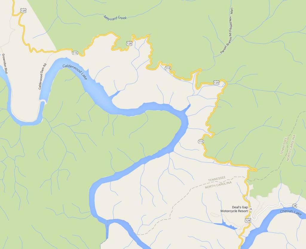
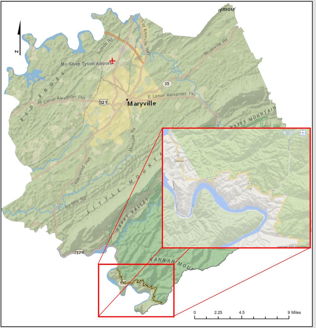
3 US 129 Location Map

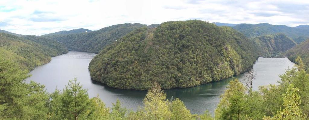
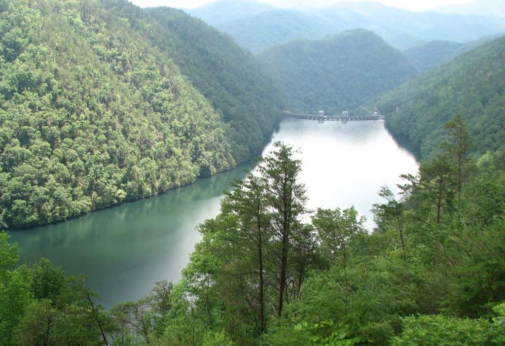
4 US 129 Topography and Scenery


5 Operational and Safety Study August 2014, US129 Operational and Safety Review Regional Alternative Routes History of Improvements Operational Review of US 129 Safety Review Commercial Vehicle Restrictions Summary and Recommendations

6 Operational Study Alternative Routes - Knoxville, TN to Robbinsville, NC Route 1: US 129 South Drive 1 h 39 min 74 mi


7 Operational Study Alternative Routes - Knoxville, TN to Robbinsville, NC Route 2: I-40 West to I-75 South to US 64 East to Drive 3 h 5 min 178 mi US 74 East to US 129 North


8 Operational Study Alternative Routes - Knoxville, TN to Robbinsville, NC Route 3: US 129 South to US 411 South to SR 68 South to Drive 2 h 55 min 140 mi US 64/74 East to US 129 North


9 Operational Study Alternative Routes - Knoxville, TN to Robbinsville, NC Route 4: I-40 East to Drive 2 h 48 min 166 mi US 23/74 West to US 19/74 West to US 129 North

10 Operational Study Alternative Routes, US129


11 Past Studies and Projects 2007 Roadway Safety Audit Review


12 Past Studies and Projects 2007 Roadway Safety Audit Review


13 Past Studies and Projects


14 Past Studies and Projects

15 Operational Study Traffic Volumes,US129

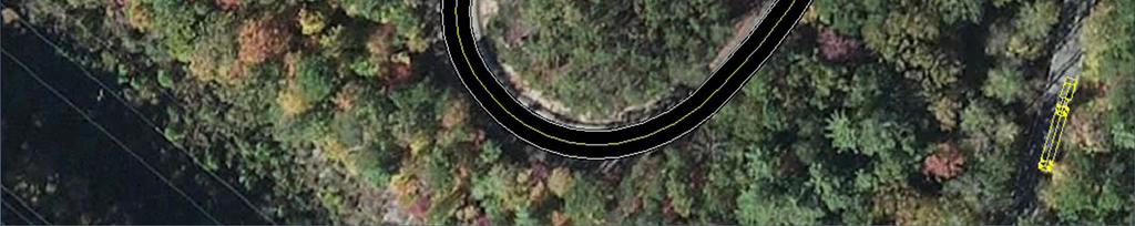
16 Operational Study Roadway Geometry Mountainous Terrain Grades 318 Curves in 11-miles Curves and Embankments limit SSD 9 feet Lane Widths Limited Shoulder Width
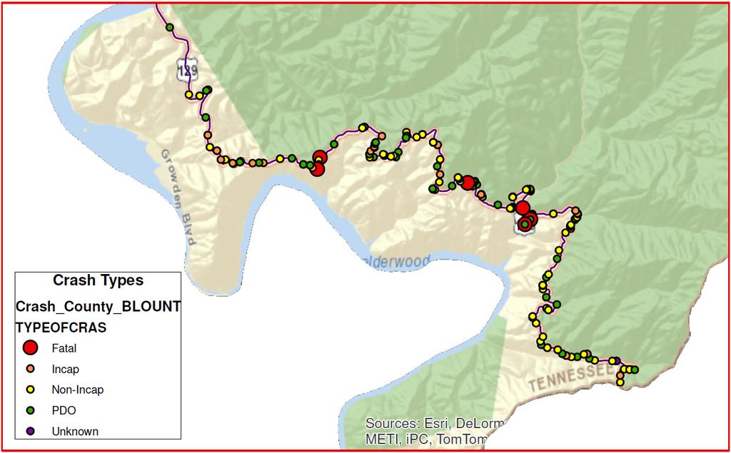
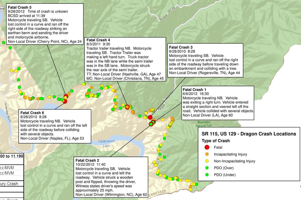
17 Operational Study GIS Crash Mapping,US129
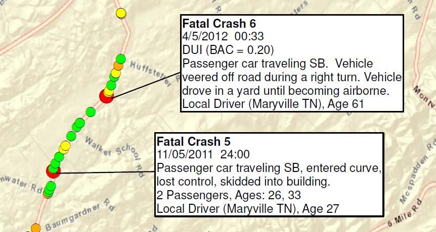
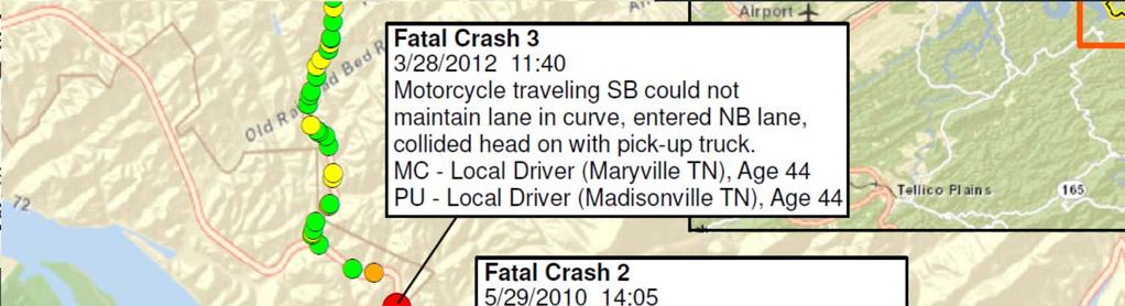
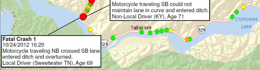
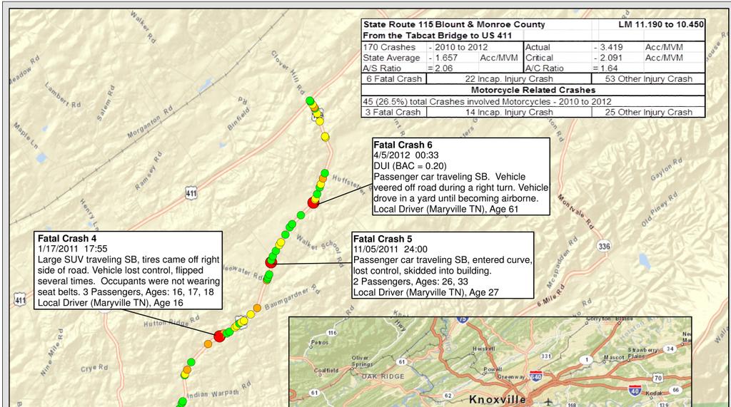
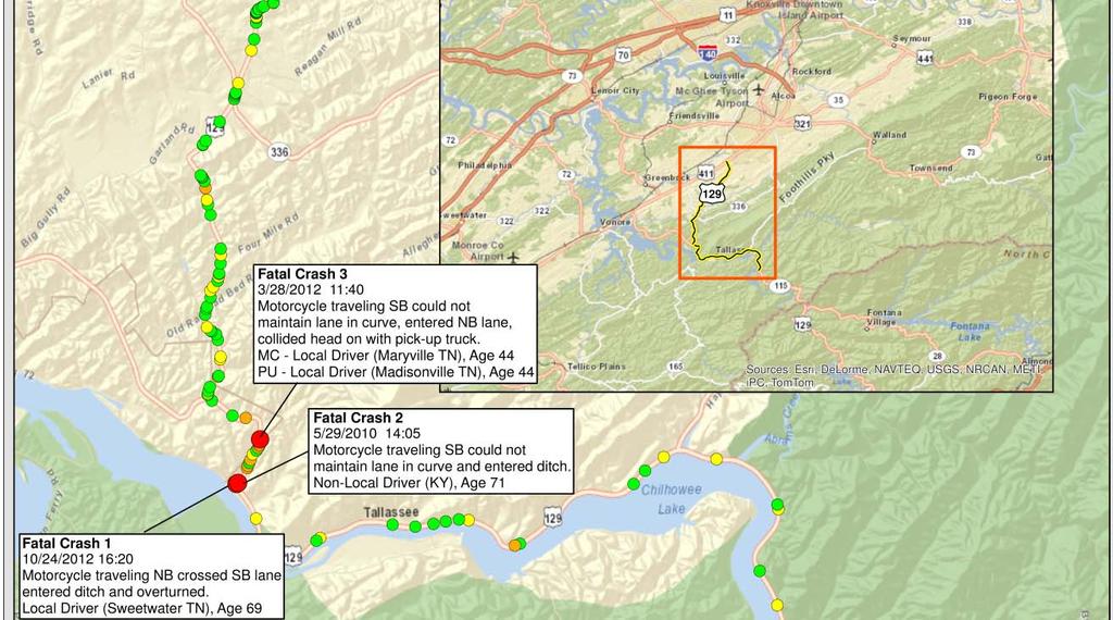
18 Operational Study GIS Crash Mapping,US129

19 Operational Study Vehicle Simulation PC: Passenger Car S-BUS-36: School Bus SU-30: Single Unit Truck SU-40: Single Unit Truck WB-40: Intermediate Semi Trailer WB-62: Interstate Semi Trailer

20 Sight Distance Length of roadway ahead that is visible to a driver 4 Types Intersection Stopping Passing Complex Decisions Special Consideration Grades Speeds Design Vehicles

21 Stopping Sight Distance Driving along the Major Roadway Stopping sight distance is provided continuously along each highway or street so that drivers have a view of the roadway ahead that is sufficient to allow drivers to stop, AASHTO pg 650 & 651.


22 Grades and Effect on Stopping Distance Grade Speed mph Braking Distance for sum of approaching vehicles Sum of Reaction Distance t=2.5 sec Distance if approaching vehicle is in your lane 0% % % %

23 Stopping Distance with Approaching Vehicles

24 Stopping Distance with Approaching Vehicles
25 Operational Study Restrictions in North Carolina, US129 Current ordinance was effective July 11, They do allow exclusion to one business to operate after sunset with an escort. Past ordinance 8/29/2008 through 7/12/2012 Restricted no through trucks with trailers longer than 30 feet Prohibited all trucks with trailers longer than 48 feet between the Cheoah Dam and the Tennessee State Line.


26 Coordination Meetings and Partners Restrictions in Tennessee, US129 Commissioner and Chief of Staff Community Relations Office HQ Traffic & Permits Strategic Transportation Investments Division Region 1 Director s Office Region 1 Traffic Region 1 Incident Management Region 1 Sign and Marking

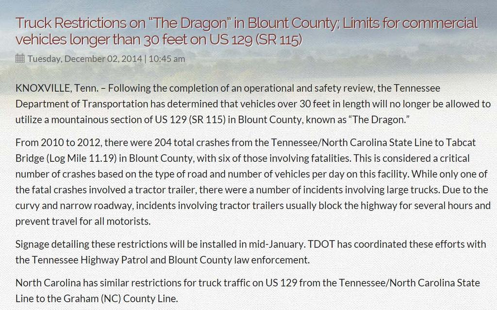
27 News Release Restrictions in Tennessee, US129


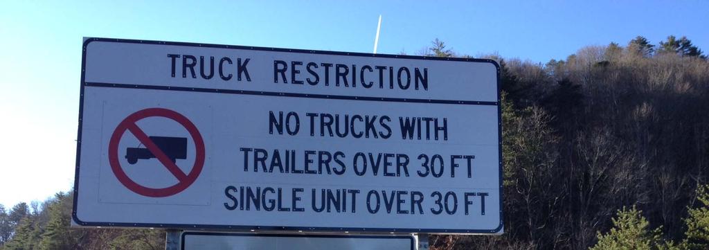
28 Restriction Signs for Tennessee Contractor Replaces Truck Advisories with Regulatory Signs


29 Restriction Signs for Tennessee Placed in North Carolina

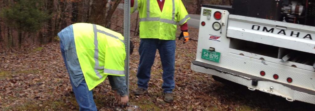
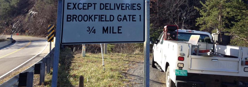
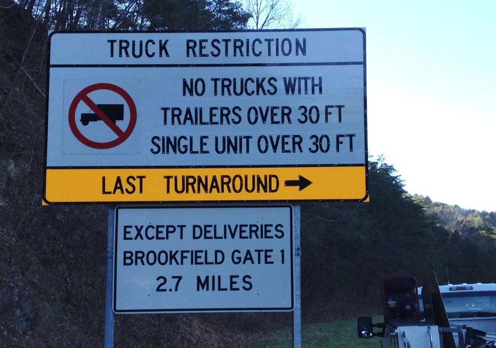
30 Exception Signs for Brookfield Smoky Mountain Hydro
31 Project Impacts Crash Data Evaluation Years Mile Post Fatals Incap Injury Total Pre 2007 RSAR Post 2007 RSAR Operational Study Post Study 2015 Past RSAR and Improvement Projects had a positive impact on Safety and Crash Reductions Truck Traffic was not eliminated with 2007 Warning initiative, 6% of AADT or 60 to 65 a day using the Mountainous section of US 129 Rollover Truck Crashes also continued to occur blocking the roadway multiple times in the Past Future Studies to evaluate Truck Restrictions in regard to Operations and Safety of route
32 Thank you NATHAN VATTER, REGION 1 TRAFFIC ENGINEER Phone: (865) Nathan.Vatter@tn.gov Questions & Comments

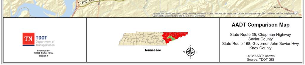
33 Chapman Highway Sevier County August 7 th 2015


34 TDOT Revenue Sources Budget FY 2015 $826 Million $976 Million $38 Million State Federal Local

35 How We Spend Our Money 2% Overhead 83% Construction Projects and Maintenance FY % 1% 2% 2% 2% 8% 15% 68% Construction Projects Maintenance & Preservation Grants Field Operations Equipment & Facility Other State Agencies Administration Other
 $312 per Capita $600.00 $500.00 $400.00 $300.00 $200.00 $312.00 $543.90 -$231.")
36 Tennessee Gas Tax Tennessee has a fixed-rate gas tax Inflation Federal gas tax $0.184 per gallon State gas tax - $0.214 per gallon Last tax increase was 1989 (25 years ago) $312 per Capita $ $ $ $ $ $ $ $ $ $

37 Fatalities & Injuries in Tennessee
38 GHSO - Chapman Safety Meeting Stakeholder Meeting January 21 st 2014 Attendees Governor s Highway Safety Office (Organizer) Sevier County Sevier County Sheriff s Office TN Highway Patrol Knoxville Police Department TDOT Meeting Purpose Discuss recent fatal and serious injury crashes and possible counter measures


39 Crash Map Henley Bridge to Sevierville ( )

40 Safety Projects Underway


41 Updated Crash Map Henley Bridge to Sevierville ( )
42 Fatal Crashes ( ) Henley Bridge to Sevierville Chapman Highway Fatalities Fatality Driver Age Speed Injury Driver Type of Crash Number Vehicle 1 Vehicle 2 Limit Driver 1 Driver 2 at Fault Correctable? 1 78 N/A 45 Run Off Road Non Incap N/A 1 No 2 54 N/A 45 Run Off Road Fatal N/A 1 No Angle Unknown Fatal 1 No Comments Passenger (Age 83) Died Alcohol was present V1 failed to yield and turned left in front of Motorcycle Angle Non Incap Non Incap 1 No 5 41 Ped = Pedestrian None Fatal Ped Maybe Head On Fatal Incap 1 Maybe Angle None Fatal 1 No 8 58 N/A 50 Run Off Road Fatal N/A 1 No Head On Fatal None 2 No Angle Fatal None 1 No Angle Non Incap Fatal 1 No N/A 55 Run Off Road Fatal N/A 1 Maybe Angle Fatal None 1 Maybe Angle Non Incap Fatal 1 Yes N/A 55 Run Off Road Fatal N/A 1 No Head On Incap Fatal 1 Maybe N/A 55 Run Off Road Fatal N/A 1 Yes Ped = Pedestrian Unknown Fatal Ped No Ped = Pedestrian None Fatal Ped No V1 attempted to cross Chapman and failed to yield Ped crossing at Meridian St (Old Wal Mart) Head On, 4 L undivided past (Old Wal Mart) NB V1 (Age 60) made U turn and NB V2 Motorcycle was unable to stop (near Ye Old) Alcohol Related V2 fell ill while driving Left turning vehicle failed to yield Driver 1 Ran Red Light/ V2 Passenger (Age 56) Fatal High Speed (From Crash Report) V1 (Age19) left turning from Canyon Hills struck by NB V2 V1 lost control when braking for stopped vehicle attempting left turn (D1 was on opiates and other drugs) Ran off the road, Alcohol and drugs were present/ Passenger (Age 2 ) possibly injured Drugs were pesent in V1/ V2 was church bus w/ 12 pass and 1 Fatal Ran off Right side of road and overturned Ped had BAC of 0.33, was either walking or standing in travel lane Pedestrian wore dark clothes/ did not respond to any vehicle horns


43 Chapman Hwy Typical Section from Seymour and Sevierville

44 Alternative 1 Widen to 5-Lane Pros Provides Efficient Operations Improves Future Capacity Improves Travel Time Reliability Improves Safety Cons Cost $40 to 50 million Time for Delivery Volume do not support concept in near future Competes for funding with other Regional Projects Project Impacts ROW Acquisition Utility Relocations


45 Alternative 2 3-Lane Pros Improves Safety Provides Center Turn Lane Buffer between opposing traffic Safe Refuge for turning traffic Reduces Rear-end crashes Improves access Provides 7 ft. paved shoulders Refuge for emergency or disabled vehicles Recovery area for errant vehicle Safe refuge for mail carrier Use for right turning traffic Correctable Problems with 3-Lane Traffic Calming and Reduces speed differentials Eliminates Weaving Simplifying road scanning and gap selection for entering vehicles Cost $1.5 to 2.5 million, Potential Safety Project through HSIP funds Cons Increases time spent following Limits Future Capacity
46 Route Comparison

47 Alternative 3 Modified 3-Lane with Passing Pros Improves Safety Provide safe designated passing areas Provides Center Turn Lane Buffer between opposing traffic Safe Refuge for turning traffic Reduces Rear-end crashes Improves access Provides 7 ft. paved shoulders Refuge for emergency or disabled vehicles Recovery area for errant vehicle Safe refuge for mail carrier Use for right turning traffic Traffic Calming and Reduces speed differentials Eliminates Weaving Simplifying road scanning & gap selection for entering vehicles Cost $1.5 to 2.5 million, Potential Safety Project, HSIP funds Cons Some time spent following Limits Future Capacity

48 Thank you NATHAN VATTER, REGION 1 TRAFFIC ENGINEER Questions & Comments
EXCEPTION TO STANDARDS REPORT
 EXCEPTION TO STANDARDS REPORT PROJECT DESCRIPTION AND NEED The project is located in Section 6, Township 23 North, Range 9 East and Section 31 Township 24 North, Range 9 East, in the Town of Stockton,
Speed Limit Study: Traffic Engineering Report
 Speed Limit Study: Traffic Engineering Report This report documents the engineering and traffic investigation required by Vermont Statutes Annotated Title 23, Chapter 13 1007 for a municipal legislative
Traffic Accident Statistics
 2000 Missouri State Highway System Traffic Accident Statistics Missouri State Highway System Traffic Accident Statistics Table of Contents Subject Chapter 1: Statewide Traffic Accident Statistics, Introduction
1999 Missouri State Highway System. Missouri Department of Transportation - Transportation Management Systems
 1999 Missouri State Highway System Traffic Accident Statistics - Transportation Management Systems Missouri State Highway System Traffic Accident Statistics Table of Contents Subject Chapter 1: Statewide
COUNTY ROAD SPEED LIMITS. Policy 817 i
 Table of Contents COUNTY ROAD SPEED LIMITS Policy 817.1 PURPOSE... 1.2 APPLICABILITY... 1.3 DEFINITIONS... 1.4 STATE ENABLING LEGISLATION... 2.5 SPEED LIMITS ON COUNTY ROADS (CCC 11.04)... 2.6 ESTABLISHING
Florida Strategic Highway Safety Planning Florida Strategic Highway Safety Plan (SHSP) Update and Performance Overview
 Update and Performance Overview") Session 1 Florida Strategic Highway Safety Planning Florida Strategic Highway Safety Plan (SHSP) Update and Performance Overview Joe Santos, PE, FDOT, State Safety Office October, 23, 2013 Florida Statistics
Session 1 Florida Strategic Highway Safety Planning Florida Strategic Highway Safety Plan (SHSP) Update and Performance Overview Joe Santos, PE, FDOT, State Safety Office October, 23, 2013 Florida Statistics
Engineering Report: Shasta-Trinity National Forest. South Fork Management Unit. Analysis of. National Forest System Road 30N44
 Engineering Report: Shasta-Trinity National Forest South Fork Management Unit Analysis of National Forest System Road 30N44 (milepost 0.00 to 0.40) for Motorized Mixed Use Designation Forest: Shasta-Trinity
NCDOT Report on Improving Safety on Secondary Roads
 April 8, 2016 NCDOT Report on Improving Safety on Secondary Roads Kevin Lacy, PE, State Traffic Engineer Overview Crash data and Safety Performance on Secondary Roads Driver Behavior Roadway Environment
Corridor Sketch Summary
 Corridor Sketch Summary SR 241: I-82 Jct (Sunnyside) to SR 24 Jct Corridor Highway No. 241 Mileposts: 7.53 to 25.21 Length: 17.65 miles Corridor Description The seventeen and one-half mile corridor begins
STH 60 Northern Reliever Route Feasibility Study Report
 #233087 v3 STH 60 Northern Reliever Route Feasibility Study Report Washington County Public Works Committee Meeting September 28, 2016 1 STH 60 Northern Reliever Route Feasibility Study Hartford Area Development
USE RESTRICTED 23 USC 409
 Study Map & Totals Legend Fatality Injury Property Damage Remarks: NONE Date Range: 01-01-2010 thru 12-31-2014 2010 2011 2012 Fat Incap Inj Non-Incap Inj Poss Inj PD Tot Fat Incap Inj Non-Incap Inj Poss
Regional Safety Action Plan and Safety Investigation Program
 Regional Safety Action Plan and Safety Investigation Program Technical Advisory Committee Meeting #3 Insert image credit here (or delete) April 17, 2018 Number of Serious Injuries New York State Serious
March 2, 2017 Integrating Transportation Planning, Project Development, and Project Programming
 COORDINATION WITH VDOT DISTRICTS TO DELIVER IMPLEMENTABLE IMPROVEMENT PROJECTS March 2, 2017 Integrating Transportation Planning, Project Development, and Project Programming PRESENTATION OUTLINE What
ACCIDENT REVIEW FORM
 ACCIDENT REVIEW FORM American Trucking Associations, Inc. Safety Management Council 950 N. Glebe Road, Suite 210, Arlington, VA 22203-4181 Fax: 703-838-1965 E-Mail: JPierce@trucking.org Members of the
VIADUCT LOCATION STUDY. October 19, 2009
 VIADUCT LOCATION STUDY October 19, 2009 Background Information Traffic Study Alternative Evaluation Public Involvement Preferred Concept Next Steps Evaluate alternatives for the location of a viaduct to
traversing them. Speed dips may be installed in lieu of speed humps where the 85 th percentile speed on a street is at least 36 mph.
 County of San Mateo Department of Public Works Residential Speed Control Device Program PURPOSE The purpose of the Residential Speed Control Devices 1 Program is to provide a consistent, fair and cost-effective
/13/D /14/W /14/D /12/D /16/D /15/D /14/D /18/D /15/D /11/W SR 18
 Windfall Rd SI = 0.18 10-20-13/2/D 08-15-15/14/D 07-16-13/16/D 05-06-15/15/D 01-19-09/12/W 09-29-14/17/D 11-10-09/7/D 01-08-10/7/S 04-26-11/3/W 01-30-10/15/D 12-20-11/14/W 11-16-10/14/W 07-26-08/18/W 07-08-13/15/D
3.15 SAFETY AND SECURITY
 3.15 SAFETY AND SECURITY Introduction This section describes the environmental setting and potential effects of the alternatives analyzed in this EIR with regard to safety and security in the SantaClara-Alum
USE RESTRICTED 23 USC 409
 Created: 04/29/2016 by Randy Woods Study Map & Totals Legend Fatality Injury Property Damage Remarks: NONE Date Range: 01-01-2006 thru 12-31-2015 2006 2007 2008 Fat Incap Inj Non-Incap Inj Poss Inj PD
2015 Community Report Grants
 5 Grants Produced for the New Mexico Department of Transportation, Traffic Safety Division, Traffic Records Bureau, Under Contract 58 by the University of New Mexico, Geospatial and Population Studies,
Male Semi-Truck Driver Killed In Rollover Crash On County Road Incident Number: 05KY008
 Male Semi-Truck Driver Killed In Rollover Crash On County Road Incident Number: 05KY008 Photograph of county road where a semi-tractor trailer left the pavement and turned over. Grade is steeper than it
TITLE 16. TRANSPORTATION CHAPTER 27. TRAFFIC REGULATIONS AND TRAFFIC CONTROL DEVICES
 NOTE: This is a courtesy copy of this rule. The official version can be found in the New Jersey Administrative Code. Should there be any discrepancies between this text and the official version, the official
Predictive Analytics for TDOT HELP. AASHTO STSMO Meeting September 14, 2017 Rapid City, South Dakota
 Predictive Analytics for TDOT HELP AASHTO STSMO Meeting September 14, 2017 Rapid City, South Dakota What is Predictive Analytics? An analysis tool that uses historical and current data to forecast future
Summary of the Alcoa Highway Redevelopment Project
 Appendix B Summary of the Alcoa Highway Redevelopment Project By Marcia Finfer, October 2009 The Timberlake community, along with numerous other concerned citizen groups (including the Lakemoor Hills community)
Southern Windsor County 2016 Traffic Count Program Summary April 2017
 Southern Windsor County 2016 Traffic Count Program Summary April 2017 The Southern Windsor County Regional Planning Commission (the RPC ) has been monitoring traffic at 19 locations throughout the southern
On-Street Electric Vehicle Charging Stations - Parking Amendments
 / STAFF REPORT ACTION REQUIRED On-Street Electric Vehicle Charging Stations - Amendments Date: August 20, 2012 To: From: Toronto and East York Community Council Acting Director, Transportation Infrastructure
Western ND Meeting. February 19, 2014 Grant Levi, NDDOT Director
 Western ND Meeting February 19, 2014 Grant Levi, NDDOT Director 1 Traffic Trends in North Dakota 2 Truck Traffic 2008 3 Truck Traffic 2012 4 Average Daily Traffic 5 ND Vehicle Miles Traveled Statewide
2016 Community Report Los Alamos County
 6 Los Alamos County Produced for the New Mexico Department of Transportation, Traffic Safety Division, Traffic Records Bureau, Under Contract 58 by the University of New Mexico, Geospatial and Population
2015 Community Report White Rock
 5 White Rock Produced for the New Mexico Department of Transportation, Traffic Safety Division, Traffic Records Bureau, Under Contract 58 by the University of New Mexico, Geospatial and Population Studies,
2014 Community Report Portales
 4 Portales Produced for the New Mexico Department of Transportation, Traffic Safety Division, Traffic Records Bureau, Under Contract 58 by the University of New Mexico, Geospatial and Population Studies,
2014 Community Report Luna County
 4 Luna County Produced for the New Mexico Department of Transportation, Traffic Safety Division, Traffic Records Bureau, Under Contract 58 by the University of New Mexico, Geospatial and Population Studies,
2016 Community Report Torrance County
 6 Torrance County Produced for the New Mexico Department of Transportation, Traffic Safety Division, Traffic Records Bureau, Under Contract 58 by the University of New Mexico, Geospatial and Population
2015 Community Report Torrance County
 5 Torrance County Produced for the New Mexico Department of Transportation, Traffic Safety Division, Traffic Records Bureau, Under Contract 58 by the University of New Mexico, Geospatial and Population
Figure 1 Map of intersection of SR 44 (Ravenna Rd) and Butternut Rd
 and Butternut Rd") Abbreviated Study District: 12 County: Geauga Route: SR 44 Section: 1.58 GEA 44 1.58 213 HSP # 47 (Rural Intersection) Prepared April 23, 215 By Bryan Emery Existing Conditions This study contains the
Abbreviated Study District: 12 County: Geauga Route: SR 44 Section: 1.58 GEA 44 1.58 213 HSP # 47 (Rural Intersection) Prepared April 23, 215 By Bryan Emery Existing Conditions This study contains the
2016 Community Report Portales
 6 Portales Produced for the New Mexico Department of Transportation, Traffic Safety Division, Traffic Records Bureau, Under Contract 58 by the University of New Mexico, Geospatial and Population Studies,
2016 Community Report De Baca County
 6 De Baca County Produced for the New Mexico Department of Transportation, Traffic Safety Division, Traffic Records Bureau, Under Contract 58 by the University of New Mexico, Geospatial and Population
Crash Contributing Factors 2016
 s 2016 RURAL ANIMAL ON ROAD- DOMESTIC ANIMAL ON ROAD- WILD BACKED WITHOUT SAFETY USE - OTHER USE - TALKING USE - TEXTING USE - UNKNOWN CHANGED LANE WHEN UNSAFE HEADLAMPS STOP LAMPS TAIL LAMPS TURN SIGNAL
Crash Contributing Factors 2015
 s 2015 RURAL ANIMAL ON ROAD- DOMESTIC ANIMAL ON ROAD- WILD BACKED WITHOUT SAFETY USE - OTHER USE - TALKING USE - TEXTING USE - UNKNOWN CHANGED LANE WHEN UNSAFE HEADLAMPS STOP LAMPS TAIL LAMPS TURN SIGNAL
Current Corridor Characteristics. MN 62 Corridor Performance
 Corridor Context The corridor runs 12 miles between I-494 and MN 55 south of Minneapolis. The corridor serves as an important East-West connection for the Metro area. A portion of the corridor has been
2014 Community Report Las Vegas
 4 Las Vegas Produced for the New Mexico Department of Transportation, Traffic Safety Division, Traffic Records Bureau, Under Contract 58 by the University of New Mexico, Geospatial and Population Studies,
2014 Community Report Truth or Consequences
 4 Truth or Consequences Produced for the New Mexico Department of Transportation, Traffic Safety Division, Traffic Records Bureau, Under Contract 58 by the University of New Mexico, Geospatial and Population
2015 Community Report Las Vegas
 5 Las Vegas Produced for the New Mexico Department of Transportation, Traffic Safety Division, Traffic Records Bureau, Under Contract 58 by the University of New Mexico, Geospatial and Population Studies,
2016 Community Report Santa Fe County
 26 Santa Fe County Produced for the New Mexico Department of Transportation, Traffic Safety Division, Traffic Records Bureau, Under Contract 58 by the University of New Mexico, Geospatial and Population
2014 Community Report Tularosa
 4 Tularosa Produced for the New Mexico Department of Transportation, Traffic Safety Division, Traffic Records Bureau, Under Contract 8 by the University of New Mexico, Geospatial and Population Studies,
2015 Community Report Tularosa
 5 Tularosa Produced for the New Mexico Department of Transportation, Traffic Safety Division, Traffic Records Bureau, Under Contract 58 by the University of New Mexico, Geospatial and Population Studies,
Letter EL652 City of Mercer Island. Page 1. No comments n/a
 Letter EL652 City of Mercer Island Page 1 No comments n/a Page 2 Response to comment EL652 1 Section 4.5.3 of the Final EIS presents the range of potential impacts of the project. This project also lists
Safety Assessment. Intersection of Route 29 (Seminole Trail) and Ashwood Blvd (Route 1670). Albemarle County
 and Ashwood Blvd (Route 1670). Albemarle County") Safety Assessment for Intersection of Route 29 (Seminole Trail) and Ashwood Blvd (Route 1670). Albemarle County Prepared by: VIRGINIA DEPARTMENT OF TRANSPORTATION Northwestern Regional Operations - Traffic
Safety Assessment for Intersection of Route 29 (Seminole Trail) and Ashwood Blvd (Route 1670). Albemarle County Prepared by: VIRGINIA DEPARTMENT OF TRANSPORTATION Northwestern Regional Operations - Traffic
2016 Community Report San Juan County
 26 San Juan County Produced for the New Mexico Department of Transportation, Traffic Safety Division, Traffic Records Bureau, Under Contract 58 by the University of New Mexico, Geospatial and Population
2015 Community Report San Juan County
 25 San Juan County Produced for the New Mexico Department of Transportation, Traffic Safety Division, Traffic Records Bureau, Under Contract 58 by the University of New Mexico, Geospatial and Population
2015 Community Report Doña Ana County
 25 Doña Ana County Produced for the New Mexico Department of Transportation, Traffic Safety Division, Traffic Records Bureau, Under Contract 58 by the University of New Mexico, Geospatial and Population
2014 Community Report Aztec
 Aztec Produced for the New Mexico Department of Transportation, Traffic Safety Division, Traffic Records Bureau, Under Contract 58 by the University of New Mexico, Geospatial and Population Studies, Traffic
2015 Community Report Chaparral
 5 Chaparral Produced for the New Mexico Department of Transportation, Traffic Safety Division, Traffic Records Bureau, Under Contract 58 by the University of New Mexico, Geospatial and Population Studies,
2016 Community Report Aztec
 Aztec Produced for the New Mexico Department of Transportation, Traffic Safety Division, Traffic Records Bureau, Under Contract 58 by the University of New Mexico, Geospatial and Population Studies, Traffic
2015 Community Report Aztec
 25 Aztec Produced for the New Mexico Department of Transportation, Traffic Safety Division, Traffic Records Bureau, Under Contract 58 by the University of New Mexico, Geospatial and Population Studies,
2014 Community Report Los Lunas
 4 Los Lunas Produced for the New Mexico Department of Transportation, Traffic Safety Division, Traffic Records Bureau, Under Contract 58 by the University of New Mexico, Geospatial and Population Studies,
2015 Community Report Los Lunas
 25 Los Lunas Produced for the New Mexico Department of Transportation, Traffic Safety Division, Traffic Records Bureau, Under Contract 58 by the University of New Mexico, Geospatial and Population Studies,
Leadership NC. November 8, 2018
 v Leadership NC November 8, 2018 Planning for our region s growth The Triangle is one of the fastestgrowing regions in the nation. More than 2 million people are already part of the equation, and the
Table of Contents INTRODUCTION... 3 PROJECT STUDY AREA Figure 1 Vicinity Map Study Area... 4 EXISTING CONDITIONS... 5 TRAFFIC OPERATIONS...
 Crosshaven Drive Corridor Study City of Vestavia Hills, Alabama Table of Contents INTRODUCTION... 3 PROJECT STUDY AREA... 3 Figure 1 Vicinity Map Study Area... 4 EXISTING CONDITIONS... 5 TRAFFIC OPERATIONS...
US 70 Corridor Planning for the Future
 New Bern/James City Area - Work Session US 70 Corridor Planning for the Future Brinson Elementary School Thursday, January 31, 2008 Agenda Sign-in, in, View Maps, Talk to Project Team Public Q & A Session
Michigan State Police (MSP) Post 21 - Metro North
 Post 21 - Metro North") June 2018 Revised 8/3/2018 2017 Reporting Criteria Please pay particular attention to the wording when interpreting the three levels of data gathered for this report. Crash The Crash Level analyzes data
June 2018 Revised 8/3/2018 2017 Reporting Criteria Please pay particular attention to the wording when interpreting the three levels of data gathered for this report. Crash The Crash Level analyzes data
Michigan State Police (MSP) Post 21 - Metro North
 Post 21 - Metro North") October 2017 2016 Reporting Criteria Please pay particular attention to the wording when interpreting the three levels of data gathered for this report. Crash The Crash Level analyzes data related to crash
October 2017 2016 Reporting Criteria Please pay particular attention to the wording when interpreting the three levels of data gathered for this report. Crash The Crash Level analyzes data related to crash
Traffic Safety Network Huron Valley
 June 2018 Revised 8/3/2018 2017 Reporting Criteria Please pay particular attention to the wording when interpreting the three levels of data gathered for this report. Crash The Crash Level analyzes data
Public Information Workshop
 Public Information Workshop Charlotte County-Punta Gorda MPO - Meeting Rooms A and B March 29, 2018 Welcome to the Public Information Workshop for Harborview Road Project Development and Environment (PD&E)
US 81 Bypass of Chickasha Environmental Assessment Public Meeting
 US 81 Bypass of Chickasha Environmental Assessment Public Meeting March 14, 2013 Introductions ODOT FHWA SAIC Meeting Purpose Present need for bypass Provide responses to 10/04/11 public meeting comments
YORK COUNTY FIRE TRAINING EMERGENCY VEHICLE DRIVER REFRESHER
 YORK COUNTY FIRE TRAINING EMERGENCY VEHICLE DRIVER REFRESHER DRIVER TRAINING Introduction and Overview Fire Board Policies and Requirements ISO Requirements State Laws Safety Accidents Special Hazards
Basic Project Information
 FY 2015-16 PROJECT DESCRIPTION FORM (7B) Submitting Agency: Fairfax County Basic Project Information Project Title: South Van Dorn Street and Franconia Road Interchange 7B Project Type (check one): Roadway
WELCOME PUBLIC OPEN HOUSE FOR US-64 FROM THE SH-18 INTERSECTION EAST 6.5 MILES JANUARY 10TH, 2017 PAWNEE CITY HALL, 5:30 PM
 WELCOME PUBLIC OPEN HOUSE FOR US-64 FROM THE SH-18 INTERSECTION EAST 6.5 MILES JANUARY 10TH, 2017 PAWNEE CITY HALL, 5:30 PM 1 PURPOSE OF THIS OPEN HOUSE Present information about the proposed improvements
VEHICLE NO.1- Your Vehicle. Began From. License Plate # (Street, Highway, Mile Marker, Terminal or Other Landmark) Near At VEHICLE NO.2.
 Near At VEHICLE NO.2.") Bates College Automobile Accident Report Please notify Security immediately after an incident. Complete and submit this report within 24 hours of the accident to Adam Mayo in Security. Please fill out
Bates College Automobile Accident Report Please notify Security immediately after an incident. Complete and submit this report within 24 hours of the accident to Adam Mayo in Security. Please fill out
COUNTY ROAD SPEED LIMITS. Policy 817 i
 Table of Contents COUNTY ROAD SPEED LIMITS Policy 817.1 PURPOSE... 2.2 APPLICABILITY... 2.3 DEFINITIONS... 2.4 STATE ENABLING LEGISLATION... 3.5 SPEED LIMITS ON COUNTY ROADS (CCC 11.04)... 3.6 ESTABLISHING
I-405 and SR 522/NE 145th Bus Rapid Transit. Elected Leadership Groups Meeting November 30, 2018
 I-405 and SR 522/NE 145th Bus Rapid Transit Elected Leadership Groups Meeting November 30, 2018 Agenda Welcome and Introductions Public Comment BRT Connection in Bothell Common Elements: Bus base, Station
Emergency Signal Warrant Evaluation: A Case Study in Anchorage, Alaska
 Emergency Signal Warrant Evaluation: A Case Study in Anchorage, Alaska by Jeanne Bowie PE, Ph.D., PTOE and Randy Kinney, PE, PTOE Abstract The Manual on Uniform Traffic Control Devices (MUTCD), Chapter
Chicago to St. Louis High-Speed Rail. IDOT District 8 Crossings. July 29, 2015
 Chicago to St. Louis High-Speed Rail IDOT District 8 Crossings July 29, 2015 1 History: Chicago-St. Louis Corridor» IDOT has actively developed the Chicago to St. Louis corridor since the mid 1980 s» In
YELM HWY AND MERIDIAN RD INTERSECTION IMPROVEMENTS PROJECT CONTEXT
 PROJECT CONTEXT 510 Hicks L A C E Y Mullen Rd SE Thurston County Fairgrounds Rd SE Carpenter Long Woodland Elementary Rd SE Marvin Old Paci c H w y 510 Reservation Rd SE Nisqually Indian Community Nis
Highway 18 BNSF Railroad Overpass Feasibility Study Craighead County. Executive Summary
 Highway 18 BNSF Railroad Overpass Feasibility Study Craighead County Executive Summary October 2014 Highway 18 BNSF Railroad Overpass Feasibility Study Craighead County Executive Summary October 2014 Prepared
2016 Community Report New Mexico
 216 Produced for the Department of Transportation, Traffic Safety Division, Traffic Records Bureau, Under Contract 581 by the University of, Geospatial and Population Studies, Traffic Research Unit Distributed
An Introduction to Automated Vehicles
 An Introduction to Automated Vehicles Grant Zammit Operations Team Manager Office of Technical Services - Resource Center Federal Highway Administration at the Purdue Road School - Purdue University West
RTCSNV CRASH ANALYSIS REPORT
 2011-2015 RTCSNV CRASH ANALYSIS REPORT TABLE OF CONTENTS Summary... 3 Crash Types... 4 Time and Day of Crashes... 7 Crash Factors... 9 Fatalities... 10 Driver s Behavior... 11 Crash Locations... 15 Non-Motorized
4 COSTS AND OPERATIONS
 4 COSTS AND OPERATIONS 4.1 INTRODUCTION This chapter summarizes the estimated capital and operations and maintenance (O&M) costs for the Modal and High-Speed Train (HST) Alternatives evaluated in this
SH 249 IN GRIMES COUNTY. Open House April 3, 2014
 SH 249 IN GRIMES COUNTY Open House April 3, 2014 Meeting Agenda Purpose of Meeting Today: Review the purpose and need for the SH 249 Grimes County project Review the proposed project and alternatives Discuss
Transportation accomplishments
 1 1 Welcome Transportation accomplishments Federal Funding State Funding Challenges Future Projects 2 Transportation Project: The NDDOT had a record construction season in 2011. Completed $595.6 million
Alcohol Related Accidents in Mahoning County:
 Alcohol Related Accidents in Mahoning County: 2013-2015 Alcohol Related Accidents in Mahoning County: 2013-2015 Each year the Eastgate Regional Council of Governments collects crash data from the Ohio
TRAFFIC CALMING PROGRAM
 TRAFFIC CALMING PROGRAM PROGRAM BASICS Mount Pleasant Transportation Department 100 Ann Edwards Lane Mt. Pleasant, SC 29465 Tel: 843-856-3080 www.tompsc.com The Town of Mount Pleasant has adopted a traffic
Clarksville Street Department. Fiscal Year 2018 Budget Presentation
 Clarksville Street Department Fiscal Year 2018 Budget Presentation Clarksville Street Department FY 2018 Proposed Budget 4.2% 42.0% Salaries/Benefits 53.8% Operating Expenses Capital Outlay Clarksville
Agenda. Utility Undergrounding Strategies & Laguna Canyon Road Master Plan
 Utility Undergrounding Strategies & Laguna Canyon Road Master Plan January 17, 2017 City Council Meeting 2 Agenda Progress since March 2016 Status of undergrounding and road widening between El Toro Rd.
Bella Vista Bypass Benefit Cost Analysis
 Bella Vista Benefit Cost Analysis The Benefit Cost Analysis (BCA) was performed in accordance with the ARRA guidance provided in the Federal Register. These benefits and costs were quantified in accordance
Austin Police Department. An Analysis of Traffic Fatalities 2015
 Austin Police Department An Analysis of Traffic Fatalities Prepared by the Austin Police Department Research and Planning Unit April Table of Contents Background... Overview... Terminology... Notes about
DEPARTMENT OF TRANSPORTATION OVERVIEW OF SAFETY PROGRAMS
 DEPARTMENT OF TRANSPORTATION OVERVIEW OF SAFETY PROGRAMS SAFETY PROGRAMS Federal Motor Carrier Safety Administration (FMCSA) Commercial Vehicle Safety Federal Highway Administration (FHWA ) Highway Safety
Washtenaw County Traffic Crash Data & Year Trends. Reporting Criteria
 June 2018 Revised 8/3/2018 2017 Reporting Criteria Please pay particular attention to the wording when interpreting the three levels of data gathered for this report. Crash The Crash Level analyzes data
Valley Metro: Past, Present and Future. September 11, 2014
 Valley Metro: Past, Present and Future September 11, 2014 Valley Metro Who are We? Two Boards of Directors Regional Public Transportation Authority Fund and operate regional transit services Valley Metro
Understanding and Identifying Crashes on Curves for Safety Improvement Potential in Illinois
 Understanding and Identifying Crashes on Curves for Safety Improvement Potential in Illinois Priscilla Tobias, P.E. Mouyid Islam, Ph.D. Kim Kolody, P.E. Optional Agenda Image Title Background Workflow
Open House. Highway212. Meetings. Corridor Access Management, Safety & Phasing Plan. 5:30 to 6:30 p.m. - Southwest Corridor Transportation Coalition
 Welcome Meetings 5:30 to 6:30 p.m. - Southwest Corridor Transportation Coalition 6:30 to 8:00 p.m. - Open House Why is Highway 212 Project Important? Important Arterial Route Local Support Highway 212
Highway Safety Update
 Highway Safety Update January 26, 2018 Karin Mongeon, Safety Division Bryon Fuchs, Local Government NDDOT Safety Division The Traffic Records Program Collect and analyze crash data to identify traffic
Washtenaw County Traffic Crash Data & Year Trends. Reporting Criteria
 June 2017 Revised 10/3/17 2016 Reporting Criteria Please pay particular attention to the wording when interpreting the three levels of data gathered for this report. Crash The Crash Level analyzes data
Kendall Drive Premium Transit PD&E Study Project Kick-Off Meeting SR 94/Kendall Drive/SW 88 Street Project Development and Environment (PD&E) Study
 Study") Florida Department of Transportation District Six Kendall Drive Premium Transit PD&E Study Project Kick-Off Meeting SR 94/Kendall Drive/SW 88 Street Project Development and Environment (PD&E) Study What
Florida Department of Transportation District Six Kendall Drive Premium Transit PD&E Study Project Kick-Off Meeting SR 94/Kendall Drive/SW 88 Street Project Development and Environment (PD&E) Study What
Characterization of Combined Use of County Road Segment
 Department of Public Works Inyo County, California Characterization of Combined Use of County Road Segment Segment Name: _Lone Pine No. 1_ Purpose: Which of the following does the combined-use segment
Right-of-Way Obstruction Permit Fee Structure Minneapolis Department of Public Works May 10, 2001
 Right-of-Way Obstruction Permit Fee Structure Minneapolis Department of Public Works May 10, 2001 Revised April 5, 2005 Revised January 27, 2006 Prepared by: Steve Collin, Engineer 2.5 Revised by Douglas
The Jack A. Markell Trail Delaware s Bicycle Highway New England Bike- Walk Summit
 The Jack A. Markell Trail Delaware s Bicycle Highway 2018 New England Bike- Walk Summit The Jack A. Markell Trail Sometimes a very difficult project, including significant investment and perseverance,
USE RESTRICTED 23 USC 409
 Created: 06/29/2018 by Lora Koetsier Study Map & Totals Legend Fatality Injury Property Damage Remarks: REQUEST FROM SHELBY TEMPLIN IN SAPM ON 29 JUNE 2018 Date Range: 10-03-2012 thru 10-02-2017 2012 2013
To prevent future occurrences of similar incidents, the following recommendations have been made:
 Kentucky Fatality Assessment and Control Evaluation (FACE) Program Incident Number: 10KY008 Release Date: March 30, 2012 Subject: Semi Tractor-Trailer Driver Dies in Median Crossover Crash; 10 Others Die
Driver Responsibility Points. Arrest Title
 CHART OF MOVING VIOLATIONS The following chart lists the moving violations that are designated by the Texas Department of Public Safety pursuant to statutory authority. The violations listed are subject