Spadina Subway Extension Downsview Station to Steeles Avenue Environmental Assessment
|
|
|
- Katrina Lynch
- 5 years ago
- Views:
Transcription
1 Spadina Subway Extension Downsview Station to Steeles Avenue Environmental Assessment APPENDIX Q SUBWAY OPERATIONS REPORT
2 Spadina Subway Extension Downsview Station to Steeles Avenue Environmental Assessment
3 Spadina Subway Extension Subway Operations Report Spadina Subway Extension Subway Operations Report Background As part of the 1994 Yonge-Spadina Subway Loop Environmental Assessment (EA), the long-term plan was to connect the northern termini of the two aforementioned subways, in order to reduce headway and thereby increase carrying capacity for the Yonge Subway. In 2001 the RTES revisited this need and determined that the capacity constraints could be addressed through: Terminal improvements Signaling system improvements Transfer Station (Bloor-Yonge) improvements In order to determine the environmental impacts of the Project, the Spadina Subway Extension EA study needs to identify all of the major facilities required for the Spadina Subway Extension, including any new or expanded train maintenance and storage facilities. The purpose of this report is to document the supporting operational analysis and the key decisions made as they pertain to the subway operations along the proposed extension from Downsview Station to Steeles West Station. Operating Design Criteria In order to efficiently and cost-effectively operate the proposed extension, TTC has identified the following requirements (See Attachment 3) 1) Double-crossover south of Finch West Station; 2) A 200m long tail track north of Steeles Station with provision for double-ending this storage track when the subway is extended further north; 3) No unbalanced super elevation and achieving two-minute headway; 4) Sufficient fleet additions and associated improvements to Wilson Yard; 5) A double-ended three track cross-over to allow the scheduled short-turn operation to be transferred from St. Clair West Station, north; and 6) No humped track profile (as per DM , Alignment Section 2.3.8) Additional details are provided below. Finch West Station Double Cross-over At the south end of Finch West Station, a double cross-over is required. This is to allow trains to change direction (i.e. NB train that is redirected southbound) at this station. As indicated in TTC Standards DM , a cross over consists of two turnouts in which the track between the frogs is arranged to form a continuous passage for vehicles. A double crossover consists of two intersecting crossovers with a crossing between the turnouts. Since the proposed alignment runs tangent along Keele Street, implementation of the double cross-over south of Finch West Station is relatively simple. This cross-over is required for operating flexibity, and would be required if the initial stage of the project is from Downsview Station to Finch West Station. Steeles West Station Tail Track and Cross-over For Steeles West station, a 200m long trail track north of the station is required. The tail track provides two operating features: 1. It allows overrun of the station, which is a safety feature that is required to allow trains to enter the terminal station at full speed. 2. It can provide temporary storage for a train on each track. Similar to Downsview station, the tail track has to provide provision for a double-ending track for future extension further north into York Region. The cross-over immediately to the south of Steeles West Station allows the arriving northbound trains to use either platform edge and return via the south bound track. This is essential for terminal station operations. Two-Minute Headway; The track layout must permit trains to operate at headways of 2 minutes. The headway (interval between trains) depends on the train dwell time at the stations, train acceleration and deceleration performance, track layout and location of wayside signals. One of the ways to maintain this criterion is to maintain high speeds for trains. In order to do this, the alignment must be as straight as possible. Any curvature should also be designed to accommodate for such. The TTC wishes to operate through curvature in a equilibrium condition. This is when the centrifugal force of a train negotiating a curve is balanced by the Superelevation of the track. This Superelevation is limited to 100mm and for a maximum speed of 80 km/hr a minimum curve of 750 metres radius is required, which is the desirable minimum radius for this project. When this radius is not possible a speed restriction will be necessary. All switches on this section will be the TTC Standard #9 switch. These have a diverting angle of approximately 6.4 degrees and the maximum speed in the diverging direction is 33 km/hr. The signal system will be designed according to TTC signaling practice and will be similar and compatible with the signaling on the rest of the Yonge - University - Spadina Subway route. This is a block signaling system and only one train is allowed in each signaling block, which is the distance between two stop signals. The signaling uses 'stop' and 'approach' indications and drivers operate trains manually in accordance with the indications provided by the signaling system. Page 1 of 5 Page 2 of 5
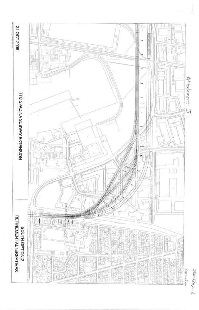
4 Spadina Subway Extension Subway Operations Report Spadina Subway Extension Subway Operations Report If a train should pass a signal indicating 'stop' a trackside trip arm contacts a trip valve on the train which initiates an emergency brake application. An overlap is provided beyond the stop signal so that the train will come to a stand before it would contact a preceding train, pass through a switch not set for the movement or contact a fouling train movement. TTC uses simulation software for the signaling and run times for proposed track configurations. As part of this study, the recommended alignment was tested. It was confirmed by TTC that the 2 minute headway was achievable for the proposed alignment and station placement on this proposed extension. Sufficient Fleet additions and associated improvements (Storage Space) The addition of 6.2 km of new subway line requires an increase in fleet, storage and maintenance facilities. The additions to the Wilson Yard are approved under the 1994 New Subway Storage and Maintenance Facility EA(See Attachment #2) and with the reopening of Davisville Yard in late 2002, and reallocation of approximately 90 subway cars to Davisville from Wilson yard, there should be sufficient train storage capacity already constructed at Wilson yard. No Humped Track Profile Within TTC Standard (DM ), a humped track profile should be used whenever possible. This design, which permits trains to accelerate out of stations and deceleration into stations, is achieved by introducing a short length (200 to 300m) of 3% up-and-down gradients before and after every station. This system increases average speeds, reduce wear and tear and reduces maintenance on motors and breaks. It also enables trains to coast, which produces energy savings. Recognizing that this is an extension of an existing line with driver control in line of sight signaling, TTC Operations asked that this D.C. be removed citing line-of-sight requirements as paramount. Scheduled Short Turns Notwithstanding the entire Spadina Subway Extension has been designed for two-minute headway, the demand for line capacity are driven by the peak loads which occur south of Bloor street on the Yonge line. In response TTC has scheduled short turns, which means northbound trains on the Spadina Subway line are returned southbound before reaching the end of the line. At present, this occurs at St. Clair West Station. With the extension of the Spadina Subway, TTC service planning have determined that the scheduled short turn location should be moved further north. As part of the 1994 EA, TTC identified that scheduled short turns should occur at Downsview station. Under construction at that time, the tail tracks for Downsview station were designed and structural provisions made for the eventual implementation. The proposed short turn facility must be configured as a centre track in order to achieve the maximum operation benefit. The desired configuration should emulate the St. Clair West Centre track which is comprised ot three switches at the south end, four switches at the north end and a bumper for small piece of overlap track extending north of the northern switches. For detailed information, please refer to Attachment 3. The double ended three-track structure requires three closely spaced tracks, with high speed switches at each end. The structure within which this specialized trackwork is accommodated has a variable structural configuration and includes structural spans of various lengths (even short sections where there are no columns in between the three tracks). Due to the complex nature of this underground structure and shallow depths, construction using exclusively TBM is not possible. It may be technically feasible to mine portions of the three track structure. However, this significantly increases the complexity of the construction, which will increase the overall construction cost, critical features such as the structural box at the switches would still need to be constructed by cut and cover. The detailed requirements for Dthe Turnaround track geometry which includes the three track structure were presented on August 29, 2005 (Attachment 4). This memo includes the calculations for the length required to accommodate a three track structure north of Downsview Station. A critical component of the three track structure is that all switch work must be on tangent track. This was in conflict with the recommended alignment (South #2 West) which included curve that extended well beyond (>400m) Downsview station. In response, a number of alignment refinments were generated including two variations of South #2 West. (see Attachment 5). South 2 Option A and Option B are various compound curves designed to minimize property impacts while still adhering to the requirment where switches must be on tangent sections. These options were analyzed and South 2 option A was selected as the preferred for the following reasons. Adherence to requirement of having switches on tangent tracks Met 2 minute headway operations (as tested by TTC) Least number of property impacts Lower capital cost Recognizing that the recommended option still required the cut and cover construction which would displace the buildings on the surface, each of the affected property owners were notified by registered mail and were given the opportunity to comment at the Page 3 of 5 Page 4 of 5
5 Spadina Subway Extension Subway Operations Report November 28, 2005 Toronto Transit Commission meeting. In response to opposition by the local businesses, TTC staff were directed to assess alternative locations for the three track structure. A variety of options were considered (See Attachment #7). The original EA option proposed that the 3-track structure be placed directly north of Downsview station. This is an extension of the 3-track until there are tangent sections available for the placement of crossovers. Option 1 involves the placement of crossover just before the Sheppard West station within Downsview Park lands. The alignment, however, will remain the same while the construction methodology will differ due to this placement. Option 2 places the 3-track structure south of the Downsview Station, close to Wilson yard. The advantage of this is that TTC already operates at the site and that major modifications are not required. Option 2 was selected as preferred as it provides the most capital and operating savings and avoids the impacts to the businesses on Kodiak Crescent. The Commission was advised that the three-track structure will be relocated to south of Downsview station, thus avoiding construction impacts on the Kodiak industrial subdivision properties verbally at its December 16, 2005 meeting, and in writing at its January 20, 2006 meeting (See Attachment 6). The three-track structure, to be located south of Downsview station, is necessary for: 1. High speed turn back of trains at Wilson Station for the operation of short-turn service from Finch Station to Wilson Station; 2. Efficient restoration of scheduled subway service in the event of incidents or emergencies; and 3. Temporary storage of subway trains and workcars. The location of this three track configuration was incorporated as part of the Wilson Yard EA and is not part of this EA (See Attachment 7) Page 5 of 5
6 Sheppard West Station Option 1 EA Concept Downsview Station Option 2 3 Track Cross Over Options EA Concept (N. of Downsview) Option 1 (PDP Lands) Option 2 (S. of Downsview Stn.) Wilson Station
7
8
9
10
11
12
13
14
15
16
17

18
19
20
Option 2 - Convert to Automatic Train Control (ATC) Signalling Technology
 Signalling Technology") Option 2 - Convert to Automatic Train Control (ATC) Signalling Technology Option 2 is substantially different from the previous options, in that replacement of the existing signalling system, rather than
Option 2 - Convert to Automatic Train Control (ATC) Signalling Technology Option 2 is substantially different from the previous options, in that replacement of the existing signalling system, rather than
3. SIGNALLING 3.1 INTRODUCTION. Present Operation - Facts and Figures
 3. SIGNALLING 3.1 INTRODUCTION Present Operation - Facts and Figures Trains on theyonge/university/spadina (Y/U/S) route of the TTC subway network are presently scheduled at a constant time interval (headway)
STAFF REPORT INFORMATION ONLY
 Insert TTC logo here STAFF REPORT INFORMATION ONLY Presentation: Subway Closures - 2016 Year In Review and 2017 Forecast Date: January 18, 2017 To: From: TTC Board Chief Executive Officer Summary The purpose
TORONTO TRANSIT COMMISSION REPORT NO.
 Form Revised: February 2005 TORONTO TRANSIT COMMISSION REPORT NO. MEETING DATE: May 28, 2009 SUBJECT: DON MILLS STATION ACTION ITEM RECOMMENDATIONS It is recommended that the Commission: 1. Endorse the
4.2 Series Station Option Description
 4.2 Series Station Option Description The series station proposal features a new set of side platforms constructed approximately 250 feet north of the existing platforms. The two new platforms would extend
Construction Staging Area 4 Avenue Road
 REPORT FOR ACTION Construction Staging Area 4 Avenue Road Date: September 27, 2017 To: Toronto and East York Community Council From: Acting Director, Transportation Services, Toronto and East York District
TORONTO TRANSIT COMMISSION REPORT NO.
 Form Revised: February 2005 TORONTO TRANSIT COMMISSION REPORT NO. MEETING DATE: October 24, 2012 SUBJECT: SCHEDULE STATUS UPDATE ACTION ITEM RECOMMENDATION It is recommended that the Commission: 1. Receive
Table Common AREMA Lateral Turnouts Currently in Use in Passenger Rail Systems
 DRAFT CHAPTER 11 SECTIONS 3.5.11.8, 3.5.11.9 Part 3 Track and Roadway Considerations SECTION 3.5 TRACK AND ROADWAY CONSIDERATIONS 3.5.11.8 Turnouts and Crossovers (2012) Turnouts and crossovers are used
TORONTO TRANSIT COMMISSION REPORT NO.
 Form Revised: February 2005 TORONTO TRANSIT COMMISSION REPORT NO. MEETING DATE: October 24, 2012 SUBJECT: DOWNTOWN RAPID TRANSIT EXPANSION STUDY (DRTES) PHASE 1 STRATEGIC PLAN ACTION ITEM RECOMMENDATIONS
Location Concept Plan Amendment Recommendation Approved 2011 Concept Plan
 Valley Line West LRT Concept Plan Recommended Amendments Lewis Farms LRT Terminus Site Location Concept Plan Amendment Recommendation Approved 2011 Concept Plan Lewis Farms LRT terminus site, 87 Avenue/West
Form Revised: February 2005 TORONTO TRANSIT COMMISSION REPORT NO. MEETING DATE: August 30, SUBJECT: Scarborough Rt Strategic Plan
 Form Revised: February 2005 TORONTO TRANSIT COMMISSION REPORT NO. MEETING DATE: August 30, 2006 SUBJECT: Scarborough Rt Strategic Plan RECOMMENDATIONS It is recommended that the Commission: 1. Endorse
EGLINTON CROSSTOWN LIGHT RAIL TRANSIT (LRT)
") WELCOME TO OUR PUBLIC OPEN HOUSE EGLINTON CROSSTOWN LIGHT RAIL TRANSIT (LRT) Preliminary Planning for a Transit Project Assessment Open House Martin Grove Road to Pearson International Airport September
WELCOME TO OUR PUBLIC OPEN HOUSE EGLINTON CROSSTOWN LIGHT RAIL TRANSIT (LRT) Preliminary Planning for a Transit Project Assessment Open House Martin Grove Road to Pearson International Airport September
Technical Memorandum. To: From: Date: October 14 th, 2018 Project #: 1302 Project Name: Subject: Distribution:
 Technical Memorandum To: Tom Hanrahan Jeff Sharp From: Date: October 14 th, 2018 Project #: 1302 Project Name: Subject: Distribution: Barrie Lockhart Road LP Conformity Review Scott Young Sorbara Group
FINAL. Sound Transit Long-Range Plan Update. Issue Paper S.1: Tacoma Link Integration with Central Link. Prepared for: Sound Transit
 Sound Transit Long-Range Plan Update Issue Paper S.1: Tacoma Link Integration with Central Link Prepared for: Sound Transit Prepared by: Quade & Douglas, Inc. FINAL March 2005 Foreword This issue paper
EGLINTON CROSSTOWN LIGHT RAIL TRANSIT (LRT) PLEASE SIGN IN
 PLEASE SIGN IN") WELCOME TO OUR PUBLIC OPEN HOUSE EGLINTON CROSSTOWN LIGHT RAIL TRANSIT (LRT) Preliminary Planning for a Transit Project Assessment June 15, 17, 18, 23, 24 and 25, 2009 PLEASE SIGN IN Members of the Project
WELCOME TO OUR PUBLIC OPEN HOUSE EGLINTON CROSSTOWN LIGHT RAIL TRANSIT (LRT) Preliminary Planning for a Transit Project Assessment June 15, 17, 18, 23, 24 and 25, 2009 PLEASE SIGN IN Members of the Project
STAFF REPORT ACTION REQUIRED
 nsert TTC logo here STAFF REPORT ACTION REQUIRED Gap Between Subway Trains and Platforms Date: November 13, 2017 To: From: TTC Board Chief Executive Officer Summary This report is in response to an October
PROJECTS $500K AND OVER FOR 2012
 EB-0-0 Page of PROJECTS $00K AND OVER FOR 0 EXTERNALLY INITIATED PLANT RELOCATIONS PORTFOLIO Table : Externally Initiated Plant Relocations Projects Estimate Estimated Cost Project Title Number ($ Millions)
5 VAUGHAN METROPOLITAN CENTRE AND SURROUNDING AREAS TRANSPORTATION STUDY PROGRESS
 5 VAUGHAN METROPOLITAN CENTRE AND SURROUNDING AREAS TRANSPORTATION STUDY PROGRESS The Transportation Services Committee recommends the adoption of the recommendations contained in the following report
Scarborough Transit Planning
 Scarborough Transit Planning April 23, 2016 Transportation Planning Section City Planning Division Overview 1. Developing Toronto s Transit Network Plan 2. Scarborough Transit Planning 1. Minutes of last
PROJECT BACKGROUND 3
 AGENDA 1. Welcome & Introductions 2. Project Background 3. Project Approach & Schedule 4. Draft Long List of Options 5. Evaluation Process 6. Next Steps 2 PROJECT BACKGROUND 3 OUR RAPID TRANSIT NETWORK
SUBJECT: Russell Hill Subway Train Accident Of August 11, 1995 Due Diligence Checklist Update
 MEETING DATE: August 31, 2005 SUBJECT: Russell Hill Subway Train Accident Of August 11, 1995 Due Diligence Checklist Update RECOMMENDATION It is recommended that the Commission: i) Receive for information
On June 11, 2012, the Park Board approved the installation of three electric vehicle charging stations along Beach Avenue.
 January 8, 2017 TO: Park Board Chair and Commissioners FROM: General Manager Vancouver Board of Parks and Recreation SUBJECT: Electric Vehicle Charging Stations New Park Board Locations RECOMMENDATION
2 MAJOR MACKENZIE DRIVE WEST JOG ELIMINATION AT HUNTINGTON ROAD CITY OF VAUGHAN
 2 MAJOR MACKENZIE DRIVE WEST JOG ELIMINATION AT HUNTINGTON ROAD CITY OF VAUGHAN The Transportation Services Committee recommends the adoption of the recommendations contained in the following report dated
TORONTO TRANSIT COMMISSION REPORT NO.
 Form Revised: February 2005 TORONTO TRANSIT COMMISSION REPORT NO. MEETING DATE: September 27, 2012 SUBJECT: NOTICE OF AWARD PROCUREMENT AUTHORIZATION - ARTICULATED BUSES INFORMATION ITEM RECOMMENDATION
Developing Toronto s Transit Network Plan to 2031
 RE:EX16.1 Developing Toronto s Transit Network Plan to 2031 Executive Committee Meeting June 28, 2016 March 2016 City Council Direction SmartTrack: Approved SmartTrack/GO Regional Express Rail (RER) Integration
Welcome to Open House #5 Scarborough Rapid Transit
 Welcome to Open House #5 Scarborough Rapid Transit Welcome to the Scarborough Rapid Transit (SRT) Conversion and Extension Study, including Kennedy Station improvements. Tonight s event provides details
Issues Facing the Panel
 Issues Facing the Panel Choice of technology for Sheppard Avenue (not for every corridor every where for all time!): subway vs. LRT Budget implications I would argue that procurement, construction management
CHANGE LIST for MDOT Traffic and Safety Geometric Design Guides. May 23, 2017: The following update was made to the web site.
 CHANGE LIST for MDOT Traffic and Safety Geometric Design Guides Note: Located at https://mdotjboss.state.mi.us/tssd/tssdhome.htm May 23, 2017: The following update was made to the web site. GEO-650-D Flares
CREATING CONNECTIONS IN THE TOWN OF NEWMARKET
 CREATING CONNECTIONS IN THE TOWN OF NEWMARKET NICK SPENSIERI, DIRECTOR, CORRIDOR INFRASTRUCTURE METROLINX ERIN MOROZ, DIRECTOR, COMMUNICATIONS AND COMMUNITY RELATIONS METROLINX APRIL 10, 2017 GRIDLOCK
The City of Toronto s Transportation Strategy July 2007
 The City of Toronto s Transportation Strategy July 2007 Presentation Outline Transportation Statistics Transportation Building Blocks Toronto s Official Plan Transportation and City Building Vision Projects
STH 60 Northern Reliever Route Feasibility Study Report
 #233087 v3 STH 60 Northern Reliever Route Feasibility Study Report Washington County Public Works Committee Meeting September 28, 2016 1 STH 60 Northern Reliever Route Feasibility Study Hartford Area Development
Scarborough ExpressRail. Technical Memo
 Scarborough ExpressRail Technical Memo By: Karl Junkin Prepared for: Transport Action Ontario February 29, 2016 Table of Contents I. Introduction... 3 II. Signal Systems... 3 III. Uxbridge Subdivision
SCARBOROUGH RAPID TRANSIT ENVIRONMENTAL PROJECT REPORT CHAPTER 2 PROJECT DESCRIPTION. Project Description
 Project Description 2 PROJECT DESCRIPTION This chapter documents the extensive preliminary planning activities undertaken prior to the commencement of this Transit Project Assessment Process. Preliminary
Transit City Etobicoke - Finch West LRT
 Delcan Corporation Transit City Etobicoke - Finch West LRT APPENDIX D Microsimulation Traffic Modeling Report March 2010 March 2010 Appendix D CONTENTS 1.0 STUDY CONTEXT... 2 Figure 1 Study Limits... 2
TORONTO TRANSIT COMMISSION REPORT NO.
 Form Revised: February 2005 TORONTO TRANSIT COMMISSION REPORT NO. MEETING DATE: MAY 6, 2010 SUBJECT: SCARBOROUGH RAPID TRANSIT TRANSIT PROJECT ASSESSMENT STUDY RECOMMENDATIONS ACTION ITEM RECOMMENDATION
Opportunities for Improved Bus Service on Finch Avenue 27 April 2011
 Opportunities for Improved Bus Service on Finch Avenue 27 April 2011 Background The inclusion of Finch Avenue as one of the higher-priority applications of light rail transit (LRT) service embodied in
To: File From: Adrian Soo, P. Eng. Markham, ON File: Date: August 18, 2015
 Memo To: From: Adrian Soo, P. Eng. Markham, ON : 165620021 Date: Reference: E.C. Row Expressway, Dominion Boulevard Interchange, Dougall Avenue Interchange, and Howard 1. Review of Interchange Geometry
T-THIRD PHASE 3 CONCEPT STUDY C: DETAILED DESCRIPTIONS OF CONCEPT ALIGNMENTS D: CONSTRUCTABILITY ANALYSIS AND COST ESTIMATES (HNTB CONSULTANTS)
") A: 2014 SFMTA TRANSIT SERVICE INFORMATION B: SFMTA TRAFFIC COUNT DATA C: DETAILED DESCRIPTIONS OF CONCEPT ALIGNMENTS D: CONSTRUCTABILITY ANALYSIS AND COST ESTIMATES (HNTB CONSULTANTS) E: LAND USE AND VALUE
A: 2014 SFMTA TRANSIT SERVICE INFORMATION B: SFMTA TRAFFIC COUNT DATA C: DETAILED DESCRIPTIONS OF CONCEPT ALIGNMENTS D: CONSTRUCTABILITY ANALYSIS AND COST ESTIMATES (HNTB CONSULTANTS) E: LAND USE AND VALUE
WELCOME TO OUR PUBLIC OPEN HOUSE Eglinton Crosstown Light Rail Transit (LRT)
") WELCOME TO OUR PUBLIC OPEN HOUSE Eglinton Crosstown Light Rail Transit (LRT) Preliminary Planning for a Transit Project Assessment November 23 rd, 24 th, 25 th, 26 th & December 2 nd, 8 th, 10 th 2009
WELCOME TO OUR PUBLIC OPEN HOUSE Eglinton Crosstown Light Rail Transit (LRT) Preliminary Planning for a Transit Project Assessment November 23 rd, 24 th, 25 th, 26 th & December 2 nd, 8 th, 10 th 2009
Developing Toronto s Transit Network Plan to Public Information Meeting June 21, 2016
 Developing Toronto s Transit Network Plan to 2031 Public Information Meeting June 21, 2016 March 2016 City Council Direction SmartTrack: Approved SmartTrack/GO Regional Express Rail (RER) Integration options
PROJECT: Wilkinson Road Corridor Improvement Traffic Management Planning Project SUBJECT: Traffic Analysis
 TECHNICAL MEMORANDUM DATE: September 10, 2014 PROJECT 5861.03 NO: PROJECT: Wilkinson Road Corridor Improvement Traffic Management Planning Project SUBJECT: Traffic Analysis TO: Steve Holroyd - District
Appendix B CTA Transit Data Supporting Documentation
 RED ED-PURPLE BYPASS PROJECT ENVIRONMENTAL ASSESSMENT AND SECTION 4(F) EVALUATION Appendix B CTA Transit Data Supporting Documentation 4( Memorandum Date: May 14, 2015 Subject: Chicago Transit Authority
Attachment 5 Eglinton West LRT Planning and Technical Update
 Eglinton West LRT Planning and Technical Update 1. Introduction In July 2016, City Council approved an Eglinton West LRT with between 8 and 12 stops between Mount Dennis and Renforth Gateway, and up to
FREQUENTLY ASKED QUESTIONS
 THE PROJECT Last updated on 9/8/16 FREQUENTLY ASKED QUESTIONS What s happening on Highway 169? The Minnesota Department of Transportation (MnDOT) is planning to rebuild and repair the infrastructure on
APPENDIX C1 TRAFFIC ANALYSIS DESIGN YEAR TRAFFIC ANALYSIS
 APPENDIX C1 TRAFFIC ANALYSIS DESIGN YEAR TRAFFIC ANALYSIS DESIGN YEAR TRAFFIC ANALYSIS February 2018 Highway & Bridge Project PIN 6754.12 Route 13 Connector Road Chemung County February 2018 Appendix
CITY CLERK. Warrants for All-Way Stop Sign Control and 40 km/h Maximum Speed Limits
 CITY CLERK Clause embodied in Report No. 9 of the, as adopted by the Council of the City of Toronto at its Special Meeting held on July 30, 31 and August 1, 2002. 10 Warrants for All-Way Stop Sign Control
Speed Limit on Railway Curves. (Use of SuperElevation on Railways)
") Speed Limit on Railway Curves (Use of SuperElevation on Railways) Introduction When a train rounds a curve, it has a tendency to want to travel in a straight direction and the track must resist this movement,
Speed Limit on Railway Curves (Use of SuperElevation on Railways) Introduction When a train rounds a curve, it has a tendency to want to travel in a straight direction and the track must resist this movement,
Bi-County Transitway/ Bethesda Station Access Demand Analysis
 Bi-County Transitway/ Bethesda Station Access Demand Analysis Prepared for: Washington Metropolitan Area Transit Authority Office of Planning and Project Development May 2005 Prepared by: in conjunction
165A 165C 165C 165A 165B. 165 WESTON ROAD NORTH January 20, 1991 To September 5, B CITY OF VAUGHAN 7
 WESTO ROAD ORTH January 20, 1991 To September 5, 1992 B southbound B buses, Barmac and Ormont to serve the B Barmac Ormont Weston --B C Lindy Lou --B-C C B -C A --B-C & Weston --B-C Av WESTO ROAD ORTH
TRAFFIC IMPACT STUDY DERRY GREEN CORPORATE BUSINESS PARK MILTON SECONDARY PLAN MODIFICATION
 TRAFFIC IMPACT STUDY DERRY GREEN CORPORATE BUSINESS PARK MILTON SECONDARY PLAN MODIFICATION TRAFFIC IMPACT STUDY DERRY GREEN CORPORATE BUSINESS PARK MILTON SECONDARY PLAN MODIFICATION DECEMBER 24 UPDATED
2017 MAX Program. Red & Blue Line Platform Extension. John Rhone Vice President, Capital Design & Construction June 22, 2017
 2017 MAX Program Red & Blue Line Platform Extension John Rhone Vice President, Capital Design & Construction June 22, 2017 Project Goals and Objectives Increase capacity: Move more passengers by 2021 with
Presentation A Blue Slides 1-5.
 Presentation A Blue Slides 1-5. 1 Presentation A Blue Slides 1-5. 2 Presentation A Blue Slides 1-5. 3 Presentation A Blue Slides 1-5. 4 Presentation A Blue Slides 1-5. 5 Transit Service right. service
APPENDIX 6: Transportation Modelling Considerations City of Toronto, February 2014
 APPENDIX 6: Transportation Modelling Considerations City of Toronto, February 2014 Transportation and Infrastructure The future of the elevated Gardiner Expressway east of Jarvis Street forms part of a
CONNECTING THE REGION
 CONNECTING THE REGION GERRY CHAPUT VICE PRESIDENT, RAPID TRANSIT, METROLINX VALUE ANALYSIS CANADA SUMMIT KEYNOTE OCTOBER 16, 2017 Metrolinx was created in 2006 by the Province of Ontario to improve the
Lineside Signal Spacing and Speed Signage
 Document comes into force and supersedes GKRT0075 Iss 3 on 05/12/15 With effect from 03/03/18 parts of this document have been superseded by Date September 15 Lineside Signal Spacing and Speed Synopsis
Note: The October 2007 version of this report has been updated in this December 2008 report to present costs in year 2007 dollars.
 Sound Transit Phase 2 South Corridor LRT Design Report: SR 99 and I-5 Alignment Scenarios (S 200 th Street to Tacoma Dome Station) Tacoma Link Extension to West Tacoma Prepared for: Sound Transit Prepared
Yonge Relief Network Study (YRNS)
") Yonge Relief Network Study (YRNS) Report for June 25 th Metrolinx Board Meeting Leslie Woo, Chief Planning Officer Anna Pace, Director, Project Planning and Development Summary of Yonge Relief Network
Yonge Relief Network Study (YRNS) Report for June 25 th Metrolinx Board Meeting Leslie Woo, Chief Planning Officer Anna Pace, Director, Project Planning and Development Summary of Yonge Relief Network
5 RAPID TRANSIT NETWORK PLAN PRINCIPLES, METROLINX BUSINESS CASE, AND ALTERNATIVE FINANCE AND PROCUREMENT ANALYSIS UPDATE
 5 RAPID TRANSIT NETWORK PLAN PRINCIPLES, METROLINX BUSINESS CASE, AND ALTERNATIVE FINANCE AND PROCUREMENT ANALYSIS UPDATE The Rapid Transit Public/Private Partnership Steering Committee recommends the
FREQUENTLY ASKED QUESTIONS
 THE PROJECT Last updated on 2/19/16 FREQUENTLY ASKED QUESTIONS What s happening on Highway 169? The Minnesota Department of Transportation (MnDOT) is planning to rebuild and repair the infrastructure on
Accessible Transit Services Plan
 - 1 Accessible Transit Services Plan 2006 Status Report - 2 Accessible Transit Services Plan 2006 Status Report 1.0 Introduction This report provides an update on activities the TTC has undertaken between
Management of Clearances
 Discipline: Engineering (Track & Civil) Category: Standard Management of Clearances ETM-7-1 Applicability New South Wales CRIA (NSW CRN) Primary Source ARTC Standards BDS 9, BDS 11, BDS 12, BDS 13, BDS
On-Street Electric Vehicle Charging Stations - Parking Amendments
 / STAFF REPORT ACTION REQUIRED On-Street Electric Vehicle Charging Stations - Amendments Date: August 20, 2012 To: From: Toronto and East York Community Council Acting Director, Transportation Infrastructure
TRAFFIC ENGINEERING ASSESSMENT MOUNT EDEN ROAD, MOUNT EDEN
 12 September 2017 Iain McManus Civitas Planning Consultants PO Box 47020 Ponsonby AUCKLAND 1144 Dear Iain, TRAFFIC ENGINEERING ASSESSMENT 43-45 45 MOUNT EDEN ROAD, MOUNT EDEN As requested, we have prepared
Alberta Infrastructure HIGHWAY GEOMETRIC DESIGN GUIDE AUGUST 1999
 &+$37(5Ã)Ã Alberta Infrastructure HIGHWAY GEOMETRIC DESIGN GUIDE AUGUST 1999 &+$37(5) 52$'6,'()$&,/,7,(6 7$%/(2)&217(176 Section Subject Page Number Page Date F.1 VEHICLE INSPECTION STATIONS... F-3 April
Train Operations Analysis of Two versus Three Mainline Tracks for the San Francisco Downtown Rail Extension
 Transbay Program Train Operations Analysis of Two versus Three Mainline Tracks for the San Francisco Downtown Rail Extension October 31, 2017 Parsons In association with JCMS, Inc. Consultants to the Transbay
Mr. Vince Mauceri General Manager Transportation Operations and Technology
 Mr. Vince Mauceri General Manager Transportation Operations and Technology METROLINX OVERVIEW AND MANDATE Established in 2006 to address the significant transportation challenges in the Greater Toronto
DOWNTOWN LRT FEASIBILITY STUDY
 INTEGRATED ENGINEERING SOLUTIONS DOWNTOWN LRT FEASIBILITY STUDY SUBMITTED TO: CITY OF CALGARY TRANSPORTATION PLANNING DIVISION SUBMITTED BY: CLIFTON ND LEA FEBRUARY 2006 INTEGRATED ENGINEERING SOLUTIONS
Table 8-1: Service Frequencies for All Short-List Alternatives by Day of Week and Time of Day Frequency Day of Week Time of Day Time Period
 8. Operating Plans The following Section presents the operating plans for the Short-List Alternatives. The modern streetcar operating plans are presented for Alternatives 2 and 3, followed by bus rapid
POLICIES FOR THE INSTALLATION OF SPEED HUMPS (Amended May 23, 2011)
") (Amended May 23, 2011) 1. Speed humps are an appropriate mechanism for reducing speeds on certain streets in Pasadena when properly installed under the right circumstances. 2. Speed humps can be considered
(Amended May 23, 2011) 1. Speed humps are an appropriate mechanism for reducing speeds on certain streets in Pasadena when properly installed under the right circumstances. 2. Speed humps can be considered
Appendix F-1 Description of the Long-Term Alternatives
 Appendix F-1 Description of the Long-Term Alternatives Memorandum Page 1 of 21 Project No. 9309 Phase 280 Date June 2, 2015 From Chris Sidlar (LEA) To Edward Presta / City of Toronto C.C. Terry Wallace
Rapid Response. Lineside Signal Spacing. Railway Group Standard GK/RT0034 Issue Three Date September 1998
 Rapid Response Railway Group Standard Lineside Signal Spacing Synopsis This Standard specifies the minimum distance that must be provided between the first signal displaying a cautionary aspect and the
APPENDIX A EVALUATION MATRIX. Toronto Transit Commission (TTC) Toronto Transit Commission (TTC) Exhibit 29: Recommended Layout for Black Creek Stop
 Toronto Transit Commission (TTC) Exhibit 29: Recommended Layout for Black Creek Stop") Exhibit 29: Recoended Layout for Black Creek Stop REVISED FINAL REPORT Toronto Transit Coission (TTC) ECLRT - JANE STREET TO KEELE STREET - VERTICAL ALIGNMENT OPTIONS March 2 Page 8 March 2 APPENDIX A
Exhibit 29: Recoended Layout for Black Creek Stop REVISED FINAL REPORT Toronto Transit Coission (TTC) ECLRT - JANE STREET TO KEELE STREET - VERTICAL ALIGNMENT OPTIONS March 2 Page 8 March 2 APPENDIX A
Table Existing Traffic Conditions for Arterial Segments along Construction Access Route. Daily
 5.8 TRAFFIC, ACCESS, AND CIRCULATION This section describes existing traffic conditions in the project area; summarizes applicable regulations; and analyzes the potential traffic, access, and circulation
Downtown One Way Street Conversion Technical Feasibility Report
 Downtown One Way Street Conversion Technical Feasibility Report As part of the City s Transportation Master Plan, this report reviews the technical feasibility of the proposed conversion of the current
Pedestrians, Cars, Buses and Trains? Considerations for Rapid Transit Service at Western University
 Pedestrians, Cars, Buses and Trains? Considerations for Rapid Transit Service at Western University Shift: The City of London s Rapid Transit Proposal Shift: The City of London s Rapid Transit Proposal
3.2 Operations Plan. 3.1 Design Principles 3. PROJECT DESCRIPTION LRT Service Bus Service
 3. PROJECT DESCRIPTION The development of the project was based on a number of inputs: 3.2 Operations Plan 3.2.1 LRT Service The studies described in Chapter 2; Design Criteria developed by the Toronto
TIMBERVINE TRANSPORTATION IMPACT STUDY FORT COLLINS, COLORADO JANUARY Prepared for:
 TIMBERVINE TRANSPORTATION IMPACT STUDY FORT COLLINS, COLORADO JANUARY 2014 Prepared for: Hartford Companies 1218 W. Ash Street Suite A Windsor, Co 80550 Prepared by: DELICH ASSOCIATES 2272 Glen Haven Drive
ASSESSMENT OF THE UPPERLEVELLOOP ALTERNATIVE FORTHE MANHATTANPORTION OF THEEASTSIDE ACCESSPROJECT
 ASSESSMENT OF THE UPPERLEVELLOOP ALTERNATIVE FORTHE MANHATTANPORTION OF THEEASTSIDE ACCESSPROJECT Preparedfor: Institute for Rational Urban Mobility, Inc. New York Preparedby: Delcan Corporation Toronto,Canada
CREATING CONNECTIONS IN EAST GWILLIMBURY
 CREATING CONNECTIONS IN EAST GWILLIMBURY NICK SPENSIERI, DIRECTOR, CORRIDOR INFRASTRUCTURE METROLINX ERIN MOROZ, DIRECTOR, COMMUNICATIONS AND COMMUNITY RELATIONS METROLINX APRIL 4, 2017 Page 8 of 146 GRIDLOCK
LAWRENCE TRANSIT CENTER LOCATION ANALYSIS 9 TH STREET & ROCKLEDGE ROAD / 21 ST STREET & IOWA STREET LAWRENCE, KANSAS
 LAWRENCE TRANSIT CENTER LOCATION ANALYSIS 9 TH STREET & ROCKLEDGE ROAD / 21 ST STREET & IOWA STREET LAWRENCE, KANSAS TRAFFIC IMPACT STUDY FEBRUARY 214 OA Project No. 213-542 TABLE OF CONTENTS 1. INTRODUCTION...
Preliminary Definition of Alternatives. 3.0 Preliminary Definition of Alternatives
 3.0 What preliminary alternatives are being evaluated? The alternatives for the East San Fernando Valley Transit Corridor project that were considered for screening include the No Build Alternative, Transportation
Welcome The City has undertaken a naming exercise for the existing and future LRT lines. The SE to West LRT, as the project has been called to date,
 Welcome The City has undertaken a naming exercise for the existing and future LRT lines. The SE to West LRT, as the project has been called to date, is now called the Valley Line. We are here to present
CAPTURING THE SENSITIVITY OF TRANSIT BUS EMISSIONS TO CONGESTION, GRADE, PASSENGER LOADING, AND FUELS
 CAPTURING THE SENSITIVITY OF TRANSIT BUS EMISSIONS TO CONGESTION, GRADE, PASSENGER LOADING, AND FUELS Ahsan Alam and Marianne Hatzopoulou, McGill University, Canada Introduction Transit is considered as
The Bloor-Danforth Subway 40 Years After Opening Why Was It So Successful? By Steve Munro March 14, Background
 The Bloor-Danforth Subway 40 Years After Opening Why Was It So Successful? By Steve Munro March 14, 2006 Background Many posts on my site make less-than-complimentary remarks about the Sheppard Subway
CREATING CONNECTIONS IN WATERLOO REGION
 CREATING CONNECTIONS IN WATERLOO REGION GORD TROUGHTON, DIRECTOR, CORRIDOR INFRASTRUCTURE CHRIS BURKE, DIRECTOR, SERVICE PLANNING ERIN MOROZ, DIRECTOR, COMMUNICATIONS AND COMMUNITY RELATIONS METROLINX
ANDERSON PROPERTY SITE ANALYSIS
 ANDERSON PROPERTY SITE ANALYSIS Introduction The Montgomery County Department of Transportation (MCDOT) initiated a feasibility study in the fall of 2012 to evaluate the need for transit service expansion
Table of Contents INTRODUCTION... 3 PROJECT STUDY AREA Figure 1 Vicinity Map Study Area... 4 EXISTING CONDITIONS... 5 TRAFFIC OPERATIONS...
 Crosshaven Drive Corridor Study City of Vestavia Hills, Alabama Table of Contents INTRODUCTION... 3 PROJECT STUDY AREA... 3 Figure 1 Vicinity Map Study Area... 4 EXISTING CONDITIONS... 5 TRAFFIC OPERATIONS...
The Engineering Department recommends Council receive this report for information.
 CORPORATE REPORT NO: R161 COUNCIL DATE: July 23, 2018 REGULAR COUNCIL TO: Mayor & Council DATE: July 19, 2018 FROM: General Manager, Engineering FILE: 8740-01 SUBJECT: Surrey Long-Range Rapid Transit Vision
Alternatives Analysis Findings Report
 6.0 This chapter presents estimates of the potential capital, operations and maintenance costs associated with the alternatives carried forward for detailed evaluation. The methodology used to develop
I-820 (East) Project Description. Fort Worth District. Reconstruct Southern I-820/SH 121 Interchange
 Project Description. Fort Worth District. Reconstruct Southern I-820/SH 121 Interchange") I-820 (East) Project Description Fort Worth District Reconstruct Southern I-820/SH 121 Interchange I-820 from approximately 2,000 feet north of Pipeline Road/Glenview Drive to approximately 3,200 feet
I-820 (East) Project Description Fort Worth District Reconstruct Southern I-820/SH 121 Interchange I-820 from approximately 2,000 feet north of Pipeline Road/Glenview Drive to approximately 3,200 feet
NEW HAVEN HARTFORD SPRINGFIELD RAIL PROGRAM
 NEW HAVEN HARTFORD SPRINGFIELD RAIL PROGRAM Hartford Rail Alternatives Analysis www.nhhsrail.com What Is This Study About? The Connecticut Department of Transportation (CTDOT) conducted an Alternatives
Regional Express Rail: Kipling Station Project Update. Ryah Kazman, Community Relations Specialist Metrolinx
 Regional Express Rail: Kipling Station Project Update Ryah Kazman, Community Relations Specialist Metrolinx GRIDLOCK COSTS OUR ECONONY Residents could spend 109 minutes per day in traffic METROLINX PLAN
Mississauga Bus Rapid Transit Preliminary Design Project
 Mississauga Bus Rapid Transit Preliminary Design Project PUBLIC INFORMATION CENTRE OCTOBER 2008 WELCOME The Mississauga Bus Rapid Transit (BRT) Project Thank you for attending this Public Information Centre.
TRAFFIC IMPACT ASSESSMENT PART OF AN ENVIRONMENTAL IMPACT ASSESSMENT FOR THE KEBRAFIELD ROODEPOORT COLLIERY IN THE PULLEN S HOPE AREA
 TRAFFIC IMPACT ASSESSMENT PART OF AN ENVIRONMENTAL IMPACT ASSESSMENT FOR THE KEBRAFIELD ROODEPOORT COLLIERY IN THE PULLEN S HOPE AREA 20 March 2014 Report prepared by: Corli Havenga Transportation Engineers
IMPROVEMENT CONCEPTS
 IMPROVEMENT CONCEPTS for the South Novato Transit Hub Study Prepared by: January 11, 2010 DKS Associates With Wilbur Smith Associates IMPROVEMENT CONCEPTS Chapter 1: Introduction 1. INTRODUCTION The strategic
4.0 TIER 2 ALTERNATIVES
 4.0 TIER 2 ALTERNATIVES The Tier 2 Alternatives represent the highest performing Tier 1 Alternatives. The purpose of the Tier 2 Screening was to identify the LPA utilizing a more robust list of evaluation
GEOMETRIC ALIGNMENT AND DESIGN
 GEOMETRIC ALIGNMENT AND DESIGN Geometric parameters dependent on design speed For given design speeds, designers aim to achieve at least the desirable minimum values for stopping sight distance, horizontal
TRANSPORTATION REVIEW
 TRANSPORTATION REVIEW - PROPOSED MIX OF LAND USES IS CONSISTENT WITH THE CITY S UNDER THE GRANVILLE BRIDGE POLICIES THAT AIM TO MEET NEIGHBOURING RESIDENTS SHOPPING NEEDS AND REDUCE RELIANCE ON AUTOMOBILE
YRRTC Business Plan
 2014 2024 YRRTC Business Plan 2014 Annual Update updated 2014 edocs #4891132 mission Our mission is to design and deliver an exceptional rapid transit system attracting, moving and connecting people to
The Belt Railway Company of Chicago CORA Guide Revision
 BRC CORA Guide Revision No. 4 July 19, 2013 Page 1 of 14 The Belt Railway Company of Chicago CORA Guide Revision BRC CORA Guide Revision No. 4 Date: July 21, 2013 Belt Railway Company of Chicago CORA Guide