TRAFFIC IMPACT ANALYSIS. for MILTON SQUARE
|
|
|
- Laureen Hodge
- 6 years ago
- Views:
Transcription
")
1 TRAFFIC IMPACT ANALYSIS for MILTON SQUARE US Route 7 Milton, Vermont March 5, 2008 LAMOUREUX & DICKINSON 14 Morse Drive Essex Junction, Vermont (802)
2 Traffic Impact Assessment EXECUTIVE SUMMARY The following presents a traffic impact assessment for the proposed expansion of the Milton Square shopping center located on US Route 7 in Milton. This Project is being developed as a planned commercial development that will effectively consolidate the existing shopping center with two other adjacent commercial lots: the Minor Funeral Home and Lot 12C of the Haydenberry Subdivision. In addition, the existing Minor Funeral Home will be relocated to a new facility constructed on a new parcel west of Haydenberry Drive. The new funeral home parcel is also a consolidation of an existing commercial parcel and a portion of Lot 9C of the Haydenberry Subdivision. The study area of this traffic impact assessment includes: Milton Square s existing signalized access onto Route 7, the Route 7 / / Railroad Street triangle of intersections, the Route 7 / Centre Drive intersection which this Project will signalize and construct a new access directly opposite Centre Drive, and the Route 7 / Haydenberry Drive intersection. Capacity analyses identified that each of the above intersections will experience acceptable levels of service upon this Project s anticipated opening in 2009 and for five-years afterwards (2014). This conclusion is predicated upon the installation of a new traffic signal and Route 7 turn lanes at the Route 7 / Centre Drive / New Project Access intersection. Analysis of two of the traffic signal warrants, Warrants 1B and 2, indicated that both will be satisfied at this location and at Milton Square s existing access. This Project will be served by three major access points (Haydenberry Drive, Centre Drive / New Access and Milton Square s existing access); all connected by a new internal roadway paralleling Route 7. This road will be a continuation of the existing roadway on the north side of McDonald s that intersects with Haydenberry Drive, and will provide off-route 7 circulation between the existing and new sections of the Milton Square shopping center and surrounding commercial lots; including McDonald s, the adjacent existing commercial building and the new Minor Funeral Home. The traffic pattern changes that will be created by this new internal roadway and its connections, combined with the relocation of the existing Hannaford s supermarket within Milton Square itself, are projected to reduce future traffic volumes on Route 7 between Centre Drive and Milton Square s existing access. Thus, this Project will not adversely affect future traffic congestion or safety along this section of Route 7.
3 Traffic Impact Assessment This study also examined the / Railroad Street intersection, which is the second highest high crash location among all intersections statewide. This examination of existing crashes indicates that the majority involve driver confusion and/or errors related to the existing three-way stop. Simply stated, despite existing signage that was installed to clarify the three-way stop, the majority of the crashes at this intersection involve vehicles on the southbound approach that are not required to stop. It is our opinion that future traffic safety conditions would be improved by implementing all-way stop control at this intersection. This Project will also construct an extensive network of internal sidewalks that will connect at several locations to the existing sidewalk network along Route 7 and other nearby streets. New crosswalks and pedestrian signals will be provided at both Milton Square s existing access and at the new access opposite Centre Drive; thus improving pedestrian safety and encouraging non-vehicular circulation.
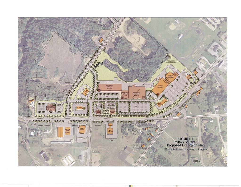
4 Traffic Impact Assessment Page INTRODUCTION The purpose of this traffic impact assessment (TIA) is to determine the potential traffic congestion and safety impacts of the proposed expansion of the Milton Square shopping center (the Project) located on the north and west sides of US Route 7 in Milton, Vermont. More specifically, this evaluation will: Project present and future background design hour traffic volumes and traffic congestion conditions at major intersections in the immediate vicinity of this Project during existing and future peak hours. Determine the future vehicular trip generation of the Project. Evaluate whether this Project will create unreasonable traffic congestion conditions. Examine existing safety conditions, and evaluate this Project's potential impact upon those conditions. Determine what traffic improvements will be required to mitigate the effects of the Project on the adjacent highway system. The existing Milton Square shopping center parcel is located on the west side of Route 7 just north of the /Railroad Street (TH #1) intersection. This section of Route 7's functional classification is an urban minor arterial. Milton Square presently has one signalized access onto Route 7. This Project will expand the existing shopping center to the west along the north side of Route 7 (Route 7 bends at the /Railroad Street intersection) on a parcel that was originally part of the adjacent Haydenberry Park commercial subdivision. Additionally, the existing Minor Funeral Home parcel which partially separates the existing shopping center from the Haydenberry Park parcel will also be acquired to be incorporated into this Project. Essentially, this Project consolidates several existing parcels to create a new planned commercial development. In turn, the Minor Funeral Home will be relocated to a new facility on the north side of Route 7 just west of Haydenberry Drive (this relocation is a separate project for permitting purposes). Figure 1 illustrates the overall project location and layout. The expanded shopping center will be accessed from several directions. First, the existing east-west internal roadway extending from Haydenberry Drive along the north side of McDonald s will be extended through the new shopping center to link with the existing shopping center. This roadway will parallel Route 7, and will link all existing and new Milton Square shopping center buildings with McDonalds, the adjacent existing small commercial building, and the new Minor Funeral Home on the opposite side of Haydenberry Drive. Secondly, the expanded shopping center will also construct a new access to Route 7 directly opposite Centre Drive. This access will extend northerly to intersect with the aforementioned east-west roadway and ultimately end at a new intersection with Haydenberry Drive. It is anticipated that this access will become this Project s primary entrance for traffic traveling to and from the south on Route 7 as well as traffic traveling to and from the Centre Drive/Bombardier Road area. To function as such, it is also anticipated
5
6 Traffic Impact Assessment Page 3 that this intersection will be signalized and widened to provide turn lanes similar to the existing shopping center access. The expanded shopping center will include a new Hannaford s supermarket, other retail and commercial space plus a new free-standing drive-in bank and a proposed restaurant. The space now occupied by Hannaford s in the existing shopping center will be renovated for future use as general retail space. It is anticipated that the new Minor Funeral Home and the new Hannaford s will begin construction in 2008, with occupancy in The entire project is anticipated to be completed within 2-3 years.
7 Traffic Impact Assessment Page BACKGROUND TRAFFIC VOLUMES For this TIA, an extensive data collection effort was undertaken to obtain existing traffic data for nearby roadways and major intersections. Automatic traffic recorder (ATR) and turning movement (TM) counts were obtained within the anticipated study area from VTrans and CCMPO. This data was also supplemented with several new TM counts performed by this office at several intersections in order to fill in gaps. Background traffic volumes for this study were then calculated by expanding and adjusting those counts as more completely outlined in the following sections. Traffic Growth Projections VTrans maintains two ATR s in the study area. ATR s D200 and D522 are located on US Route 7 immediately to the north and south of this Project, respectively. Table 1 shows the most recent count data at these two locations; while Figure 1 illustrates the 10-year growth from 1994 to D200 Table 1 - ATR Traffic Data D522 Year AADT (vpd) Peak Hour (vph) AADT (vpd) Peak Hour (vph) ,400 1, ,400 1,269 13,400 1,413 Figure ATR AADT s
8 Traffic Impact Assessment Page 5 At ATR s D200 and D522, the 10-year growth from 1994 to 2004 equaled 20% and 31%, respectively. Expressed as annual growth rates, that equals 2% and 3.1% per year, respectively. As can be seen in Figure 1, traffic growth has slowed considerably since This trend has been observed throughout Vermont. Currently, VTrans is estimating a 20-year growth rate of 10% for highways in urban areas. This is based on traffic data collected from selected continuous traffic counters (CTC) located throughout Vermont. For this TIA, future background traffic volumes within the study area were calculated using the 2006 AADT at D200 as the starting point, and applying a 2% growth rate from 2006 to 2009 and a 4% growth rate from 2006 to These VTrans growth rates are just for background growth, as opposed to growth from other nearby approved developments (which will be calculated separately) or the growth that is represented by new Project-generated trips. For traffic studies such as this, design hour volumes (DHV) are used to determine the capacity and corresponding level of service on adjacent highways and intersections. The DHV represents the 30 th highest traffic hour that occurs each year, and generally occurs on a weekday during the afternoon peak 1 hour. For this study, DHV s were calculated for years 2009 and 2014 using the following general procedure: a) The 2006 AADT at ATR Station D200 was adjusted to a 2009 AADT by applying the abovereferenced 2% growth rate. This AADT was then pivoted around the Shopping Center, Middle Road and Railroad Street intersections based on the total 12-hour traffic volumes observed during the most recent VTrans TM counts at those location. This step resulted in estimated AADT s along Route 7 north and south of the /Railroad Street intersection of 12,080 vpd and 11,680 vpd, respectively. These AADT s were then adjusted by another 2% to provide estimated 2014 AADT s of 12,320 vpd, and 11,910 vpd, respectively. b) A review of peak hour / AADT ratios observed during ATR and TM counts in the study area indicated that the recommended VTrans DHV/AADT ratio of 10.4% is too low for this area. Instead, the most recent DHV/AADT ratio of 11.6% from CTC Station D040, located approximately six miles south on Route 7 in Colchester, was used. Detailed DHV calculations are 2 included in Appendix A. c) New peak hour trips generated by other nearby approved residential and commercial developments were added to background traffic volumes, based on information received from the Town Planning & Economic Development Department. These other developments included the Ice Barn (at its currently proposed location), Blackberry Commons, LeBlanc Elderly Housing, 284 Route 7 South LLC and the Marketplace Condominiums. These five developments are estimated to generate a total of 212 peak hour trips, which were then distributed onto Route 7 and adjacent streets based on existing traffic patterns. 1 2 Along this portion of Route 7, weekday morning peak hour volumes are typically 75% - 80% of the afternoon peak hour volumes. All appendices are under separate cover.
9 Traffic Impact Assessment Page 6 Together, the estimated background DHV s and other development peak hour trips form the baseline no-build scenario for this TIA. Figures 2-6 on the following pages illustrate the resulting background design hour volumes.
10 Traffic Impact Assessment Page 7 Figure Background DHV without Other Development Existing 204 Milton Square Access 193 US Route 7 North Railroad Street Railroad Street New 0 97 Milton Square 0 0 Centre Drive Access Haydenberry 0 0 BHC Drive US Route 7 South
11 Traffic Impact Assessment Page 8 Figure Background DHV without Other Development Existing 204 Milton Square Access 193 US Route 7 North Railroad Street Railroad Street New 0 99 Milton Square 0 0 Centre Drive Access Haydenberry 0 0 BHC Drive US Route 7 South
12 Traffic Impact Assessment Page 9 Figure 4 Other Development Existing 0 Milton Square Access 0 US Route 7 North Railroad Street 13 9 Railroad Street New 14 4 Milton Square 2 1 Centre Drive Access Haydenberry 0 0 BHC Drive US Route 7 South
13 Traffic Impact Assessment Page 10 Figure Background DHV with Other Development Existing 204 Milton Square Access 193 US Route 7 North Railroad Street Railroad Street New Milton Square 0 0 Centre Drive Access Haydenberry 0 0 BHC Drive US Route 7 South
14 Traffic Impact Assessment Page 11 Figure Background DHV with Other Development Existing 204 Milton Square Access 193 US Route 7 North Railroad Street Railroad Street New Milton Square 0 0 Centre Drive Access Haydenberry 0 0 BHC Drive US Route 7 South
15 Traffic Impact Assessment Page PROJECT-GENERATED TRIPS 3 This Project s peak hour vehicular trip generation was estimated by using ITE trip generation rates for the proposed land-use categories. In this case, the existing shopping center provides the ability to compare actual trip generation rates to ITE rates; thus improving the overall trip estimation process. With trip generation data available from the most recent June 2004 VTrans Route 7 / Milton Square 12-hour TM count, the actual trip generation of the existing shopping center during the adjacent street morning and afternoon peak hours can be readily determined. Morning peak hour (7:00-8:00 am) trips equaled 202 vehicle trip ends per hour (vte/hr), and afternoon peak hour (4:45-5:45 pm) trips equaled 731 vte/hour. With the morning peak hour trips being relatively low, and the shopping center peak and adjacent street traffic peak overlapping during the afternoon peak hour, further analysis of morning traffic conditions were not performed. There are several different methods of using ITE trip generation rates to estimate this shopping center s existing trip generation. The two primary ones are shown in Table 2 on the following page. As can be seen in Table 2, the aggregate shopping center method results in 408 new project-generated peak hour trips. This method, however, significantly underestimates the existing shopping center s peak hour trip generation (479 vs 731). On the other hand, the individual store method more accurately models the existing shopping center (742 vs 731), and is therefore considered to be the better method for use in this TIA. This results in 1,369 future project-generated peak hour trips, an increase of 627 new peak hour trips. Directional distributions of weekday peak hour project trips were estimated based on existing traffic patterns at each of the existing major intersections within the study area; including the existing Milton Square, /Railroad Street, Centre Drive and Haydenberry Drive intersections. Retail stores also typically attract pass-by trips in addition to creating new primary trips. Pass-by trips are generated by motorists who are already driving by on US Route 7. Instead of simply driving by, they turn in to shop at a store, and then exit in the same direction that they were originally traveling. For example, the ITE estimates that 34% of a shopping center s trips during the weekday p.m. peak hour time period are pass-by trips. Based on that, it is possible that up to 213 of this Project s 627 new peak hour trips could be pass-by trips. However, for the purpose of this study, because the directional patterns of the new project-generated trips have been estimated primarily from existing traffic patterns, a pass-by trip adjustment has not been incorporated into the following analyses. This Project will also link with the Town of Milton s expanding sidewalk network along Route 7, Centre Drive, Haydenberry Drive and surrounding neighborhoods. Additionally, the Town of Milton very 3 th Trip Generation, Institute of Transportation Engineers, 7 Edition
16 Traffic Impact Assessment Page 13 recently voted to join the CCTA, which provides public transit in Chittenden County. We understand, though, that the proposed public transit service will be limited to providing peak hour service to and from Burlington. Thus, no adjustment has been made to reduce this Project s weekday pm peak hour trip generation to reflect multi-modal trip making. Table 2 Weekday PM Peak Hour Project-Generated Trips (vte/hr) Land-Use Code & Description Existing Proposed Size # Trips Size # Trips Aggregate Method Shopping Center 66,566 sf ,515 sf 887 Individual Store Method US Post Office Specialty Retail Hardware/Paint Store Supermarket Discount Home Furnishings* Apparel Store* Existing Walk-In Pharmacy/Drug Store New Walk-In Pharmacy/Drug Store* Existing Drive-In Bank New Drive-In Bank Existing High Turnover Restaurant New High Turnover Restaurant Total 8,000 sf 1,200 sf 7,700 sf 31,666 sf ,000 sf -- 2,200 sf -- 1,800 sf ,000 sf 1,200 sf 7,700 sf 47,000 sf 34,700 sf 31,666 sf 14,000 sf 12,000 sf 2,200 sf 3,940 sf 1,800 sf 5,400 sf ,369 * exact use to be determined Detailed calculations of new project-generated trips and their directional patterns are included as Appendix B. The resulting project trip distribution is shown in Figure 7. Figures 8 and 9 also illustrate projected 2009 and 2014 with Project DHV turning movements at each of the six intersections. Comparing the Route 7 total two-way volumes on 2009 Background (Figure 2) with 2014 Build (Figure 9), indicates that the cumulative 5-year growth in traffic volumes on Route 7 north of Milton Square and south of Haydenberry Drive will average 27%. Additionally, although background traffic growth and other development will also cause future traffic volumes at the Route 7 / / Railroad Street and / Railroad Street intersections to increase, this Project is unique in that it diverts traffic away from those intersections. This diversion is created by Haydenberry Drive and the new Project Access opposite Centre Drive intercepting existing
17 Traffic Impact Assessment Page 14 shopping center trips traveling to the shopping center northbound on Route 7, combined with both existing and new shopping center trips using the new internal shopping center roadway paralleling Route 7.
18 Traffic Impact Assessment Page 15 Figure 7 Net New Project-Generated Trips Existing 66 Milton Square Access -130 US Route 7 North Railroad Street 18 4 Railroad Street New Milton Square Centre Drive Access Haydenberry 0 0 BHC Drive US Route 7 South
19 Traffic Impact Assessment Page 16 Figure Build DHV Existing 270 Milton Square Access 63 US Route 7 North Railroad Street Railroad Street New Milton Square Centre Drive Access Haydenberry 0 0 BHC Drive US Route 7 South
20 Traffic Impact Assessment Page 17 Figure Build DHV Existing 270 Milton Square Access 63 US Route 7 North Railroad Street Railroad Street New Milton Square Centre Drive Access Haydenberry 0 0 BHC Drive US Route 7 South
21 Traffic Impact Assessment Page TRAFFIC CONGESTION ANALYSES Traffic Signal Warrants As noted earlier, the existing Milton Square shopping center is presently accessed via one signalized intersection. As can be seen in Appendix C, this Project will significantly alter existing traffic patterns at this intersection. Before performing intersection capacity analyses at this intersection and at the new Project Access intersection opposite Centre Drive, an examination of whether this Project will satisfy the traffic signal warrants at the new access opposite Centre Drive and continue to satisfy the same warrants at the existing access was performed. 4 Warrants for signalization are set forth in the MUTCD. There are several volume-related signal warrants are typically examined. For this analysis we will examine two of them: Warrant 1, Eight-Hour Vehicular Volume, Condition B - Interruption of Continuous Traffic, and Warrant 2, Four-Hour Vehicular Volume. The criteria for both is included as Appendix C. The criteria for Warrant 1B are that the major street volume (total of both approaches) must equal 750 vph and the minor street approach volume (exiting traffic only) must equal 75 vph for each of any 8 hours of a typical weekday. The criteria for Warrant 2 are a bit more complex, as the combination of major and minor street volumes must fall above the appropriate curve (the 1 lane & 1 lane) for each of any 4 hours of a typical weekday. That curve has a minimum minor street volume of 80 vph at higher major street volumes. In order to examine these two warrants, weekday traffic volumes on Route 7 (major street) were calculated from the October 2006 VTrans TM count at the Route 7 / / Railroad Street intersection. In addition, minor street approach volumes were taken from the June 2004 VTrans TM count at the Milton Square intersection. Those volumes provide hourly data, from 6:00 am to 6:00 pm, of the volumes of traffic exiting Milton Square. Additional hourly data for the 6:00-7:00 pm hour were estimated from the 2006 VTrans Station D200 ATR count and from shopping center hourly trip patterns contained in Trip Generation. These hourly variations were then used to calculate projected approach volumes based on ratios applied to the projected peak hour volumes exiting this Project at both locations. It should be noted that the foregoing calculations do not include any allowance for background traffic growth since 2006 or for added Route 7 traffic generated by other approved developments. Right-turns were excluded and the minor street approach examined as a single lane at both intersections. Detailed calculations of the foregoing are also included in Appendix C. The results of the signal warrant examination are presented in Table 3 on the following page. These results indicate that both Warrants 1B and 2 will continue to be satisfied at Milton Square s existing signalized access. At this Project s new access opposite Centre Drive, Warrant 1B s criteria are 4 Manual on Uniform Traffic Control Devices, Federal Highway Administration, 2003
22 Traffic Impact Assessment Page 19 satisfied for 7 of the required 8 hours. Thus, Warrant 1B is not satisfied. However, if the two hours noted as close in Table 3 are included, Warrant 1B would be satisfied at this access as well. Warrant 2 is also satisfied for the required 4 hours at this intersection, with 2 additional hours noted as close. Hour Major Street Volume Table 3 - Signal Warrant Examination Existing Milton Square Access Minor Street Volume New Project Access Warrant Satisfied? Major Minor Warrant Satisfied? Street Street 1B 2 Volume Volume 1B N N N N N N N N Y N close N N N N N N N N N Y Y close N Y Y Y close Y Y Y N Y Y Y close Y Y Y Y Y Y Y Y Y Y Y Y Y Y Y Y # Hours Satisfied 9 8 # Hours Satisfied 7 4 # Hours Required 8 4 # Hours Required 8 4 Warrant Satisfied? Y Y Warrant Satisfied? N Y Intersection Capacity & Levels of Service For development projects such as this, intersection capacity analyses are typically conducted using Highway Capacity Manual procedures. These analyses produce a rating known as level of service (LOS), which range from A (best) to F (poor). At intersections, the LOS is determined by the average control delay; measured in seconds per vehicle. The methodology for analyzing LOS is established by the
23 Traffic Impact Assessment Page 20 5 Highway Capacity Manual (HCM), and the analyses themselves can be performed using several computer programs designed specifically for this purpose. The programs HCS v5.2 and Synchro v6 hve been used to perform the following analyses in order to better analyze overall traffic congestion conditions and signal coordination along the Route 7 corridor in the immediate vicinity of this Project. Table 4 summarizes the HCM LOS/delay criteria for intersections. Table 4 - Level of Service/Delay Criteria Avg. Delay (sec/veh) Avg. Delay (sec/veh LOS Signalized Unsignalized LOS Signalized Unsignalized A B C D E F > >50 As can be seen in Table 4, the HCM sets lower delays for a given LOS at unsignalized intersections vs. signalized intersections. This has been done due to the fact that motorists at unsignalized intersections tend to be less patient when faced with long delays than those at signalized intersections. 6 VTrans Level of Service Policy effectively establishes desired LOS standards for the state highway system. For signalized intersections, an overall rating of LOS C represents the desired design target. At unsignalized intersections, LOS D represents the desired design target for side roads having approach volumes exceeding 100 vph on a single-lane approach or 150 vph on a two-lane approach. There is no LOS design target on side roads having approach volumes lower than the foregoing thresholds. Table 5 presents the results of the intersection capacity analyses at each study area intersection. Following Table 5 is a discussion of the results at each intersection. Detailed level of service analysis worksheets for each intersection are also included in Appendices D-I. 5 6 Highway Capacity Manual, Transportation Research Board, 2000 Highway Design Level of Service Policy, Vermont Agency of Transportation, May 31, 2007
24 Traffic Impact Assessment Page 21 Table 5 - Intersection Levels of Service Intersection No-Build Build No-Build Build Route 7 / Haydenberry Drive E* D* F* E* Route 7 / Centre Drive / New Project Access E B E B Route 7 Railroad Street D D D D Route 7 / C C C C / Railroad Street B B B B Route 7 / Milton Square B B B B * less than 150 vph on a two-lane approach Route 7 / Haydenberry Drive - This intersection is presently stop sign controlled. Originally constructed for the Haydenberry commercial/residential development, this intersection has been previously improved with exclusive left- and right-turn lanes on Route 7 as well as separate left- and right-turn lanes on Haydenberry Drive. As noted in Table 5, the Haydenberry Drive approach volumes are less than 150 vph even with this project, therefore the VTrans LOS policy is not applicable to this intersection. While this Project will increase right-turns exiting Haydenberry Drive, the LOS improvement results from leftturning vehicles instead taking advantage of the new signalized access opposite Centre Drive. Route 7 / Centre Drive / New Project Access - Future levels of service will be improved by the proposed signalization and installation of new Route 7 turning lanes at this intersection. The proposed improvements also include pedestrian crosswalks and signals, emergency vehicle preemption (as Centre Drive is the primary exit route for fire apparatus to Route 7), and coordination with the existing Milton Square signal to the north. For the purpose of this analysis, protected left-turn traffic signal phasing on Route 7 was used. Route 7 / Railroad Street & Route 7 / - Although this Project will not change the level of service rating at these two intersections, it will result in a small reduction in vehicular delays by diverting existing traffic that would otherwise travel through them. / Railroad Street - This intersection presently operates as three-way stop control with stop signs on all but the southbound approach. Since neither HCS or Synchro are capable of analyzing that particular type of stop control, the capacity analyses at this intersection were performed using all-way stop control. Route 7 / Milton Square - This intersection is proposed to remain largely unchanged by this Project. It is anticipated, however, that the existing traffic signal will be upgraded to include new pedestrian
25 Traffic Impact Assessment Page 22 crosswalks and signals, emergency vehicle preemption and coordination with the new Centre Drive signal to the south. Internally, do not block intersection signage and pavement markings will be added on the Milton Square access approach in order to prevent the occasional interference that presently occurs. Additionally, while there are no changes in future levels of service at this intersection, this Project will reduce the 95% queue lengths in the Route 7 left-turn lane from 195 ft to 75 ft. Internally, queuing of exiting vehicles will also be improved by the overall reduction in exiting peak hour traffic at this location and the change from a roughly 50/50 split between left and right turns to an 80/20 split.
26 Traffic Impact Assessment Page MINOR FUNERAL HOME This Project includes relocating the existing Minor Funeral Home to the northwest corner of Route 7 and Haydenberry Drive. This will involve two commercial parcels separate from the proposed expanded Milton Square shopping center. The existing Minor Funeral Home is approximately, 5,400 sf in gross floor area, and accesses directly onto Route 7 via its own driveway; which will be closed. The proposed new funeral home will be approximately 11,400 sf in gross floor area, and will have a full access onto Haydenberry Drive directly opposite Milton Square s new internal roadway that will parallel Route 7. The two Route 7 curb cuts serving the existing commercial lots at the Funeral Home s new location will also be closed, and replaced with a new right-turn only entrance/exit onto Route 7. The location and configuration of the new Route 7 access has been previously reviewed with VTrans in order to address access management and sight distance concerns. In particular, the left-turn exiting movement from this new access will be prohibited due to less than adequate sight distances to the west caused by the curve in Route 7 at Bombardier Road. Since, funerals and visiting hours are typically scheduled in the morning, mid-afternoon and early evening time periods, the new funeral home will have a very minimal impact on future traffic congestion conditions. An estimate of the funeral home s existing and proposed weekday peak hour trip generation was developed by using trip generation rates from ITE Trip Generation land-use code #560 - Church. Applying the above floor areas, the existing funeral home is estimated to generate 4 vte/hour and the new funeral home estimated to generate 8 vte/hour, for a net gain of 4 vte/hour.
27 Traffic Impact Assessment Page TRAFFIC SAFETY Vehicular traffic safety is influenced by many factors, including road width, pavement conditions, sight distances, lighting, proper signing and pavement markings, speed limits, alignment, number and spacing of accesses, etc. The following discusses several of the more important factors with respect to conditions on the adjacent street network in the immediate vicinity of the proposed Milton Square shopping center. Sight Distance The existing speed limit on US Route 7 is 35 mph west (south) of the curve at the Railroad Street and intersections. It reduces to 25 mph just prior to that curve, and continues at 25 mph northward through the existing Milton Square intersection and beyond. Sight distances at both project access intersections exceed the recommended standard of 390 ft for 35 mph. Crash History The most recent VTrans High Crash Location Report identifies the section of Route 7 extending from the curve at the Railroad Street and intersections (mm 3.917) to the Rebecca Lander Drive (High School) intersection (mm 4.217) as being a high crash location. This section has an actual/critical ratio of The / Railroad Street intersection (the existing 3-way stop intersection off from Route 7) is also identified as a high crash location with 22 crashes during the period. This intersection has an actual/critical ratio of 2.346, and is ranked as the #2 high crash intersection statewide. Related to the crash experience at this intersection, the section of Railroad Street extending from mm 0.00 (Route 7) to mm is also listed as a high crash location. As noted earlier, this Project is projected to divert existing and proposed shopping center trips in such a way that will reduce future traffic volumes through the / Railroad Street intersection and along Route 7 between the Railroad Street and existing Milton Square intersections. This reduction effectively mitigates this Project s potential traffic safety impact in each of the above high crash locations. As part of this TIA, this office also performed a detailed review of individual accident reports for the five-year period at the / Railroad Street intersection. A total of 23 accidents were examined, of which 16 were found to involve confusion and driver error related to the lack of stop control on the southbound approach. It is our opinion that the crash history of the / Railroad Street intersection could be improved by replacing the existing three-way stop control with all-way stop control. Apparently, all-way stop control has not previously been used at this location due to concerns about traffic on the southbound approach backing up through the Route 7 intersection. At unsignalized intersections,
28 Traffic Impact Assessment Page 25 7 AASHTO recommends sufficient stacking distance to accommodate 2 minutes of average arrivals. The 2014 with Project approach volume at this location equals 138 vph, or 2.3 vehicles per minute. At 25 ft per vehicle and for a 2 minute time period, applying the aforementioned AASHTO standard would require 125 ft of stacking. There is presently 169 ft of stacking distance between Route 7 and Railroad Street on this approach; which indicates that Route 7 overflow should not be an issue during the afternoon peak hour. Since this is the one approach within the study area where morning peak hour volumes are higher than afternoon peak hour volumes, potential stacking requirements during the morning peak hour were also checked. Future morning peak hour volumes on the southbound approach are projected to be just less than 180 vph, or 3 vehicles per minute. That would require 150 ft of stacking, again well within what is available to avoid backing up through the Route 7 intersection. Pedestrian Safety This Project includes sidewalks which will link with the existing sidewalk and path network along Route 7, Centre Drive, Railroad Street, and Haydenberry Drive. The two signalized intersections at the existing and new Project accesses will be provided with marked crosswalks and pedestrian signals. Overall While this Project will bring increased traffic volumes to its two major access intersections, the roadway and intersection improvements identified in this study will be designed to provide safe traffic conditions. All proposed roadway and intersection improvements made as part of this Project, including pavement markings, lighting and signage, will be constructed in accordance with current VTrans design standards. We also conclude that this Project will not adversely impact existing or future traffic safety conditions at the triangle intersections of Route 7, and Railroad Street. It is also our opinion that future safety conditions in this immediate area could be improved by the installation of four-way stop control at the / Railroad Street intersection. 7 A Policy on Geometric Design of Highway and Streets, American Association of State Highway and Transportation Officials, 2004
29 Traffic Impact Assessment Page 26 Bibliography Traffic Impact Study Guidelines, Vermont Agency of Transportation Policy and Planning Division Traffic Research Unit, revised November 2007 Highway Design Level of Service Policy, Vermont Agency of Transportation, May 31, 2007 th Trip Generation, Institute of Transportation Engineers, 7 Edition Highway Capacity Manual, Transportation Research Board, 2000 A Policy on Geometric Design of Highways and Streets, American Association of State Highway and Transportation Officials, 2004 Traffic Counts ATR D200, US Route 7, Milton, VTrans, 2004 & 2006 ATR D522, US Route 7, Milton, VTrans, 2004 TM Count, US Route 7 & Milton Square, VTrans, June 10-11, 2004 TM Count, US Route 7 & Milton Square, CCMPO, July 22, 2004 Milton Post Office PM Peak Hour Trip Generation Count, L&D, October 26, 2006 TM Count, US Route 7, & Railroad Street, VTrans, October 11-12, 2006 TM Count, & Railroad Street, VTrans, October 11-12, 2006 TM Count, US Route 7 & Centre Drive, L&D, October 24, 2006 TM Count, US Route 7 & Haydenberry Drive, CCMPO, July 12, 2004 TM Count, US Route 7 & Bombardier Road, CCMPO, June 24, 2004
TRAFFIC IMPACT ANALYSIS
 TRAFFIC IMPACT ANALYSIS Emerald Isle Commercial Development Prepared by SEPI Engineering & Construction Prepared for Ark Consulting Group, PLLC March 2016 I. Executive Summary A. Site Location The Emerald
LAWRENCE TRANSIT CENTER LOCATION ANALYSIS 9 TH STREET & ROCKLEDGE ROAD / 21 ST STREET & IOWA STREET LAWRENCE, KANSAS
 LAWRENCE TRANSIT CENTER LOCATION ANALYSIS 9 TH STREET & ROCKLEDGE ROAD / 21 ST STREET & IOWA STREET LAWRENCE, KANSAS TRAFFIC IMPACT STUDY FEBRUARY 214 OA Project No. 213-542 TABLE OF CONTENTS 1. INTRODUCTION...
King Soopers #116 Thornton, Colorado
 Traffic Impact Study King Soopers #116 Thornton, Colorado Prepared for: Galloway & Company, Inc. T R A F F I C I M P A C T S T U D Y King Soopers #116 Thornton, Colorado Prepared for Galloway & Company
APPENDIX C1 TRAFFIC ANALYSIS DESIGN YEAR TRAFFIC ANALYSIS
 APPENDIX C1 TRAFFIC ANALYSIS DESIGN YEAR TRAFFIC ANALYSIS DESIGN YEAR TRAFFIC ANALYSIS February 2018 Highway & Bridge Project PIN 6754.12 Route 13 Connector Road Chemung County February 2018 Appendix
Traffic Engineering Study
 Traffic Engineering Study Bellaire Boulevard Prepared For: International Management District Technical Services, Inc. Texas Registered Engineering Firm F-3580 November 2009 Executive Summary has been requested
CHAPTER 9: VEHICULAR ACCESS CONTROL Introduction and Goals Administration Standards
 9.00 Introduction and Goals 9.01 Administration 9.02 Standards 9.1 9.00 INTRODUCTION AND GOALS City streets serve two purposes that are often in conflict moving traffic and accessing property. The higher
Traffic Impact Study for the proposed. Town of Allegany, New York. August Project No Prepared For:
 Appendix B SRF Traffic Study (Revised November 2005) Draft Environmental Impact Statement University Commons Town of Allegany, Cattaraugus County, NY December 2005 Traffic Impact Study for the proposed
Traffic Impact Study Speedway Gas Station Redevelopment
 Traffic Impact Study Speedway Gas Station Redevelopment Warrenville, Illinois Prepared For: Prepared By: April 11, 2018 Table of Contents 1. Introduction... 1 2. Existing Conditions... 4 Site Location...
RE: A Traffic Impact Statement for a proposed development on Quinpool Road
 James J. Copeland, P.Eng. GRIFFIN transportation group inc. 30 Bonny View Drive Fall River, NS B2T 1R2 May 31, 2018 Ellen O Hara, P.Eng. Project Engineer DesignPoint Engineering & Surveying Ltd. 200 Waterfront
Table of Contents INTRODUCTION... 3 PROJECT STUDY AREA Figure 1 Vicinity Map Study Area... 4 EXISTING CONDITIONS... 5 TRAFFIC OPERATIONS...
 Crosshaven Drive Corridor Study City of Vestavia Hills, Alabama Table of Contents INTRODUCTION... 3 PROJECT STUDY AREA... 3 Figure 1 Vicinity Map Study Area... 4 EXISTING CONDITIONS... 5 TRAFFIC OPERATIONS...
TRAFFIC SIGNAL DESIGN REPORT KING OF PRUSSIA ROAD & RAIDER ROAD RADNOR TOWNSHIP PENNSYLVANIA
 TRAFFIC SIGNAL DESIGN REPORT KING OF PRUSSIA ROAD & RAIDER ROAD RADNOR TOWNSHIP PENNSYLVANIA PREPARED FOR: UNIVERSITY OF PENNSYLVANIA HEALTH SYSTEM 34 CIVIC CENTER BOULEVARD PHILADELPHIA, PA 1987 (61)
2.0 Development Driveways. Movin Out June 2017
 Movin Out June 2017 1.0 Introduction The proposed Movin Out development is a mixed use development in the northeast quadrant of the intersection of West Broadway and Fayette Avenue in the City of Madison.
Traffic Impact Analysis West Street Garden Plots Improvements and DuPage River Park Garden Plots Development Naperville, Illinois
 Traffic Impact Analysis West Street Garden Plots Improvements and DuPage River Park Garden Plots Development Naperville, Illinois Submitted by April 9, 2009 Introduction Kenig, Lindgren, O Hara, Aboona,
Proposed location of Camp Parkway Commerce Center. Vicinity map of Camp Parkway Commerce Center Southampton County, VA
 Proposed location of Camp Parkway Commerce Center Vicinity map of Camp Parkway Commerce Center Southampton County, VA Camp Parkway Commerce Center is a proposed distribution and industrial center to be
TIMBERVINE TRANSPORTATION IMPACT STUDY FORT COLLINS, COLORADO JANUARY Prepared for:
 TIMBERVINE TRANSPORTATION IMPACT STUDY FORT COLLINS, COLORADO JANUARY 2014 Prepared for: Hartford Companies 1218 W. Ash Street Suite A Windsor, Co 80550 Prepared by: DELICH ASSOCIATES 2272 Glen Haven Drive
Section 5.0 Traffic Information
 Section 5.0 Traffic Information 10.0 TRANSPORTATION MDM Transportation Consultants, Inc. (MDM) has prepared an evaluation of transportation impacts for the proposed evaluation for the expansion of the
West Hills Shopping Centre Lowe s Expansion Traffic Impact Study
 West Hills Shopping Centre Lowe s Expansion Traffic Impact Study Prepared for: Armel Corporation January 2015 Paradigm Transportation Solutions Ltd. 22 King Street South, Suite 300 Waterloo ON N2J 1N8
TRAFFIC PARKING ANALYSIS
 TRAFFIC PARKING ANALYSIS NAPA FLEA MARKET COUNTY OF NAPA Prepared for: Tom Harding Napa-Vallejo Flea Market 33 Kelly Road American Canyon, CA 9453 Prepared by: 166 Olympic Boulevard, Suite 21 Walnut Creek,
Date: February 7, 2017 John Doyle, Z-Best Products Robert Del Rio. T.E. Z-Best Traffic Operations and Site Access Analysis
 Memorandum Date: February 7, 07 To: From: Subject: John Doyle, Z-Best Products Robert Del Rio. T.E. Z-Best Traffic Operations and Site Access Analysis Introduction Hexagon Transportation Consultants, Inc.
Appendix J Traffic Impact Study
 MRI May 2012 Appendix J Traffic Impact Study Level 2 Traffic Assessment Limited Impact Review Appendix J [This page was left blank intentionally.] www.sgm-inc.com Figure 1. Site Driveway and Trail Crossing
RTE. 1 at RTE. 637 & RTE. 639
 INTERSECTION SAFETY STUDY Prepared for: Virginia Department of Transportation Central Region Operations Traffic Engineering (UPC #81378, TO 12-092) DAVENPORT Project Number: 13-368 / /2014 RTE. 1 at RTE.
Craig Scheffler, P.E., PTOE HNTB North Carolina, P.C. HNTB Project File: Subject
 TECHNICAL MEMORANDUM To Kumar Neppalli Traffic Engineering Manager Town of Chapel Hill From Craig Scheffler, P.E., PTOE HNTB North Carolina, P.C. Cc HNTB Project File: 38435 Subject Obey Creek TIS 2022
1. INTRODUCTION 2. PROJECT DESCRIPTION CUBES SELF-STORAGE MILL CREEK TRIP GENERATION COMPARISON
 CUBES SELF-STORAGE MILL CREEK TRIP GENERATION COMPARISON 1. INTRODUCTION This report summarizes traffic impacts of the proposed CUBES Self-Storage Mill Creek project in comparison to the traffic currently
Traffic Impact Study Proposed Residential Development (Watson Parkway North - Starwood Drive Node, City of Guelph)
") Traffic Impact Study Proposed Residential Development (Watson Parkway North - Starwood Drive Node, City of Guelph) Prepared By: 332 Lorne Avenue East Stratford ON N5A 6S4 Prepared for: Paul Kemper, President
Traffic Impact Study Proposed Residential Development (Watson Parkway North - Starwood Drive Node, City of Guelph) Prepared By: 332 Lorne Avenue East Stratford ON N5A 6S4 Prepared for: Paul Kemper, President
King County Metro. Columbia Street Transit Priority Improvements Alternative Analysis. Downtown Southend Transit Study. May 2014.
 King County Metro Columbia Street Transit Priority Improvements Alternative Analysis Downtown Southend Transit Study May 2014 Parametrix Table of Contents Introduction... 1 Methodology... 1 Study Area...
The major roadways in the study area are State Route 166 and State Route 33, which are shown on Figure 1-1 and described below:
 3.5 TRAFFIC AND CIRCULATION 3.5.1 Existing Conditions 3.5.1.1 Street Network DRAFT ENVIRONMENTAL IMPACT REPORT The major roadways in the study area are State Route 166 and State Route 33, which are shown
Appendix C. Traffic Study
 Appendix C Traffic Study TABLE OF CONTENTS SECTION Executive Summary PAGE 1.0 Introduction... 1 1.1 Scope of Work... 1 1.2 Study Area... 2 2.0 Project Description... 3 2.1 Site Access... 4 2.2 Pedestrian
TRAFFIC IMPACT ANALYSIS FOR. McDONALD S RESTAURANT IN CARMICAEL Sacramento County, CA. Prepared For:
 TRAFFIC IMPACT ANALYSIS FOR McDONALD S RESTAURANT IN CARMICAEL Sacramento County, CA Prepared For: McDonald s USA, LLC Pacific Sierra Region 2999 Oak Road, Suite 900 Walnut Creek, CA 94597 Prepared By:
HUMC/Mountainside Hospital Redevelopment Plan
 Traffic and Parking Analysis HUMC/Mountainside Hospital Redevelopment Plan in Glen Ridge Borough and Montclair Township PREPARED FOR H2M 119 Cherry Hill Road, Suite 110 Parsippany, NJ 07054 862.207.5900
MINERVA PARK SITE TRAFFIC IMPACT STUDY M/I HOMES. September 2, 2015
 5500 New Albany Road Columbus, Ohio 43054 Phone: 614.775.4500 Fax: 614.775.4800 Toll Free: 1-888-775-EMHT emht.com 2015-1008 MINERVA PARK SITE TRAFFIC IMPACT STUDY M/I HOMES September 2, 2015 Engineers
EXECUTIVE SUMMARY. The following is an outline of the traffic analysis performed by Hales Engineering for the traffic conditions of this project.
 EXECUTIVE SUMMARY This study addresses the traffic impacts associated with the proposed Shopko redevelopment located in Sugarhouse, Utah. The Shopko redevelopment project is located between 1300 East and
Transportation & Traffic Engineering
 Transportation & Traffic Engineering 1) Project Description This report presents a summary of findings for a Traffic Impact Analysis (TIA) performed by A+ Engineering, Inc. for the Hill Country Family
INDUSTRIAL DEVELOPMENT
 INDUSTRIAL DEVELOPMENT Traffic Impact Study Plainfield, Illinois August 2018 Prepared for: Seefried Industrial Properties, Inc. TABLE OF CONTENTS Executive Summary 2 Introduction 3 Existing Conditions
APPENDIX E. Traffic Analysis Report
 APPENDIX E Traffic Analysis Report THIS PAGE INTENTIONALLY BLANK EAGLE RIVER TRAFFIC MITIGATION PHASE I OLD GLENN HIGHWAY/EAGLE RIVER ROAD INTERSECTION IMPROVEMENTS TRAFFIC ANALYSIS Eagle River, Alaska
GASOLINE SERVICE STATION 1618, 1622 ROGER STEVENS DRIVE OTTAWA, ONTARIO TRANSPORTATION IMPACT ASSESSMENT. Prepared for:
 GASOLINE SERVICE STATION 1618, 1622 ROGER STEVENS DRIVE OTTAWA, ONTARIO TRANSPORTATION IMPACT ASSESSMENT Prepared for: Invecta Development (Ottawa) Corporation 758 Shanks Height Milton, ON L9T 7P7 May
DEVELOPMENT PROPERTY 1627 MAXIME STREET CITY OF OTTAWA TRANSPORTATION OVERVIEW. Prepared for: Subhas Bhargava. July 9, Overview_1.
 DEVELOPMENT PROPERTY 1627 MAXIME STREET CITY OF OTTAWA TRANSPORTATION OVERVIEW Prepared for: Subhas Bhargava July 9, 2015 115-620 Overview_1.doc D. J. Halpenny & Associates Ltd. Consulting Transportation
Traffic Impact Study for Proposed Olive Boulevard Development
 Traffic Impact Study for Proposed 11330 Olive Boulevard Development Creve Coeur, Missouri July 7, 2017 Prepared For: 11330 Olive Boulevard Development 11330 Olive Boulevard Creve Coeur, Missouri 63141
APPENDIX B Traffic Analysis
 APPENDIX B Traffic Analysis Rim of the World Unified School District Reconfiguration Prepared for: Rim of the World School District 27315 North Bay Road, Blue Jay, CA 92317 Prepared by: 400 Oceangate,
Traffic Impact Statement (TIS)
") Traffic Impact Statement (TIS) Vincentian PUDA Collier County, FL 10/18/2013 Prepared for: Global Properties of Naples Prepared by: Trebilcock Consulting Solutions, PA 2614 Tamiami Trail N, Suite 615 1205
Traffic Impact Statement (TIS) Vincentian PUDA Collier County, FL 10/18/2013 Prepared for: Global Properties of Naples Prepared by: Trebilcock Consulting Solutions, PA 2614 Tamiami Trail N, Suite 615 1205
A Gap-Based Approach to the Left Turn Signal Warrant. Jeremy R. Chapman, PhD, PE, PTOE Senior Traffic Engineer American Structurepoint, Inc.
 A Gap-Based Approach to the Left Turn Signal Warrant Jeremy R. Chapman, PhD, PE, PTOE Senior Traffic Engineer American Structurepoint, Inc. March 5, 2019 - The problem: Existing signalized intersection
Re: Addendum No. 4 Transportation Overview 146 Mountshannon Drive Ottawa, Ontario
 April 18 th, 2017 Mr. Kevin Yemm Vice President, Land Development Richraft Group of Companies 2280 St. Laurent Boulevard, Suite 201 Ottawa, Ontario (Tel: 613.739.7111 / e-mail: keviny@richcraft.com) Re:
IRSCH REEN Hirsch/Green Transportation Consulting, Inc.
 IRSCH REEN Hirsch/Green Transportation Consulting, Inc. February 6, 2013 Mr. David Weil Director of Finance St. Matthew s Parish School 1031 Bienveneda Avenue Pacific Palisades, California 90272 RE: Trip
MERIVALE PRIORITY SQUARE 2852 MERIVALE ROAD CITY OF OTTAWA TRANSPORTATION BRIEF. Prepared for: ONT Inc. 25 Winding Way Nepean, Ontario K2C 3H1
 MERIVALE PRIORITY SQUARE 2852 MERIVALE ROAD CITY OF OTTAWA TRANSPORTATION BRIEF Prepared for: 2190986ONT Inc. 25 Winding Way Nepean, Ontario K2C 3H1 October 6, 2010 110-502 Report_1.doc D. J. Halpenny
ANDERSON PROPERTY SITE ANALYSIS
 ANDERSON PROPERTY SITE ANALYSIS Introduction The Montgomery County Department of Transportation (MCDOT) initiated a feasibility study in the fall of 2012 to evaluate the need for transit service expansion
Table 1 - Land Use Comparisons - Proposed King s Wharf Development. Retail (SF) Office (SF) 354 6,000 10, Land Uses 1
 Office (SF) 354 6,000 10, Land Uses 1") Ref. No. 171-6694 Phase 2 November 23, 217 Mr. David Quilichini, Vice President Fares & Co. Developments Inc. 31 Place Keelson Sales Centre DARTMOUTH NS B2Y C1 Sent Via Email to David@faresinc.com RE:
Ref. No. 171-6694 Phase 2 November 23, 217 Mr. David Quilichini, Vice President Fares & Co. Developments Inc. 31 Place Keelson Sales Centre DARTMOUTH NS B2Y C1 Sent Via Email to David@faresinc.com RE:
Access Management Standards
 Access Management Standards This section replaces Access Control Standards on Page number 300-4 of the Engineering Standards passed February 11, 2002 and is an abridged version of the Access Management
BARRHAVEN FELLOWSHIP CRC 3058 JOCKVALE ROAD OTTAWA, ONTARIO TRANSPORTATION BRIEF. Prepared for:
 BARRHAVEN FELLOWSHIP CRC 3058 JOCKVALE ROAD OTTAWA, ONTARIO TRANSPORTATION BRIEF Prepared for: Barrhaven Fellowship CRC 3058 Jockvale Road Ottawa, ON K2J 2W7 December 7, 2016 116-649 Report_1.doc D. J.
appendix 4: Parking Management Study, Phase II
 appendix 4: Parking Management Study, Phase II A4-1 A4-2 Eastlake Parking Management Study Final Phase 2 Report Future Parking Demand & Supply January 6, 2017 Submitted by Denver Corp Center III 7900 E.
IV. ENVIRONMENTAL IMPACT ANALYSIS K.2. PARKING
 IV. ENVIRONMENTAL IMPACT ANALYSIS K.2. PARKING ENVIRONMENTAL SETTING The following analysis summarizes the findings and conclusions of the Traffic Analysis (Traffic Study), prepared by The Mobility Group,
Oakbrook Village Plaza City of Laguna Hills
 Oakbrook Village Plaza City of Laguna Hills Traffic Impact Analysis Prepared by: HDR Engineering 3230 El Camino Real, Suite 200 Irvine, CA 92602 October 2012 Revision 3 D-1 Oakbrook Village Plaza Laguna
Alpine Highway to North County Boulevard Connector Study
 Alpine Highway to North County Boulevard Connector Study prepared by Avenue Consultants March 16, 2017 North County Boulevard Connector Study March 16, 2017 Table of Contents 1 Summary of Findings... 1
105 Toronto Street South, Markdale Transportation Impact Study. Paradigm Transportation Solutions Limited
 105 Toronto Street South, Markdale Transportation Impact Study Paradigm Transportation Solutions Limited December 2016 Project Summary Project Number 162060 December 2016 Client Zelinka Priamo Ltd 318
Appendix H TRAFFIC IMPACT ANALYSIS
 Appendix H TRAFFIC IMPACT ANALYSIS Teichert Boca Quarry Expansion Traffic Impact Analysis Prepared for Teichert Aggregates Prepared by TRANSPORTATION CONSULTANTS, INC. LSC Transportation Consultants, Inc.
Escondido Marriott Hotel and Mixed-Use Condominium Project TRAFFIC IMPACT ANALYSIS REPORT
 Escondido Marriott Hotel and Mixed-Use Condominium Project TRAFFIC IMPACT ANALYSIS REPORT Prepared for Phelps Program Management 420 Sixth Avenue, Greeley, CO 80632 Prepared by 5050 Avenida Encinas, Suite
RICHMOND OAKS HEALTH CENTRE 6265 PERTH STREET OTTAWA, ONTARIO TRANSPORTATION BRIEF. Prepared for: Guycoki (Eastern) Limited.
 Limited.") RICHMOND OAKS HEALTH CENTRE 6265 PERTH STREET OTTAWA, ONTARIO TRANSPORTATION BRIEF Prepared for: Guycoki (Eastern) Limited June 16, 2016 116-638 Brief_1.doc D. J. Halpenny & Associates Ltd. Consulting
RICHMOND OAKS HEALTH CENTRE 6265 PERTH STREET OTTAWA, ONTARIO TRANSPORTATION BRIEF Prepared for: Guycoki (Eastern) Limited June 16, 2016 116-638 Brief_1.doc D. J. Halpenny & Associates Ltd. Consulting
Proposed Inn at Bellefield Traffic Impact Assessment
 Proposed Inn at Bellefield Traffic Impact Assessment Town of Hyde Park Dutchess County, New York Prepared for: T-Rex Hyde Park Owner LLC 500 Mamroneck Avenue, Suite 300 Harrison, NY 10528 June 21, 2017
APPENDIX C-2. Traffic Study Supplemental Analysis Memo
 APPENDIX C-2 Traffic Study Supplemental Analysis Memo The Mobility Group Transportation Strategies & Solutions Memorandum To: From: Subject: Tomas Carranza, LADOT Matthew Simons Traffic Review - Revised
RE: 67/71 Marquette Avenue Redevelopment Transportation Overview
 1223 Michael Street, Suite 100, Ottawa, Ontario K1J 7T2 Tel: 613.738.4160 Fax: 613.739.7105 www.delcan.com April 23, 2014 OUR REF: TO3157TOA00 BY EMAIL: mark.larose@urbanrisedevelopment.com Urban Rise
TRANSPORTATION STUDY FOR THE 8899 BEVERLY BOULEVARD PROJECT
 DRAFT TRANSPORTATION STUDY FOR THE 8899 BEVERLY BOULEVARD PROJECT WEST HOLLYWOOD, CALIFORNIA NOVEMBER 2013 PREPARED FOR BEVERLY BOULEVARD ASSOCIATION PREPARED BY DRAFT TRANSPORTATION STUDY FOR THE 8899
TALMONT TOWNHOMES MADISON KENNETH SPA TRAFFIC IMPACT STUDY. Sacramento, CA. Prepared For: MBK Homes. Prepared By:
 TALMONT TOWNHOMES MADISON KENNETH SPA TRAFFIC IMPACT STUDY Sacramento, CA Prepared For: MBK Homes Prepared By: KD Anderson & Associates 3853 Taylor Road, Suite G Loomis, California 95650 (916) 660-1555
Construction Realty Co.
 MEMORANDUM TO: FROM : Jeff Pickus Construction Realty Co. Luay R. Aboona, PE Principal 9575 West Higgins Road, Suite 400 Rosemont, Illinois 60018 p: 847-518-9990 f: 847-518-9987 DATE: May 22, 2014 SUBJECT:
TABLE OF CONTENTS 1.0 INTRODUCTION AND SUMMARY Purpose of Report and Study Objectives... 2
 TABLE OF CONTENTS 1.0 INTRODUCTION AND SUMMARY 1 1.1 Purpose of Report and Study Objectives... 2 1.2 Executive Summary... 3 1.2.1 Site Location and Study Area... 3 1.2.2 Development Description... 3 1.2.3
Volume 1 Traffic Impact Analysis Turtle Creek Boulevard Dallas, Texas. Kimley-Horn and Associates, Inc. Dallas, Texas.
 Volume 1 Traffic Impact Analysis 2727 Dallas, Texas June 18, 2018 Kimley-Horn and Associates, Inc. Dallas, Texas Project #064523000 Registered Firm F-928 Traffic Impact Analysis 2727 Dallas, Texas Prepared
Lakeside Terrace Development
 Lakeside Terrace Development City of Barrie, County of Simcoe Traffic Brief for: Type of Document: Final Report Project Number: JDE 1617 Date Submitted: April 29 th, 216 4/29/16 John Northcote, P.Eng.
Proposed CVS/pharmacy
 Traffic Impact and Access Study Proposed CVS/pharmacy West Main Street (Route 1) at Hull Street Clinton, Connecticut PREPARED FOR Arista Development LLC 520 Providence Highway, Suite 9 Norwood, Massachusetts
L1TILE BEARS DAY CARE TRANSPORTATION IMPACT STUDY FORT COLLINS, COLORADO MAY Prepared for:
 L1TILE BEARS DAY CARE TRANSPORTATION IMPACT STUDY FORT COLLINS, COLORADO MAY 2012 Prepared for: Hillside Construction, Inc. 216 Hemlock Street, Suite B Fort Collins, CO 80534 Prepared by: DELICH ASSOCIATES
November 1, Mr. Jafar Tabrizi President, Tabrizi Rugs 180 Bedford Highway. Traffic Impact Statement BH-1 and BH-2, Southgate Drive, Bedford, NS
 161-12598 Mr. Jafar Tabrizi President, Tabrizi Rugs 180 Bedford Highway Bedford, NS B4A 1C1 [Via Email: tabrizi@tabrizi.com] RE: Traffic Impact Statement Dear Mr. Tabrizi: Plans are being prepared for
Traffic Feasibility Study
 Traffic Feasibility Study Town Center South Robbinsville Township, Mercer County, New Jersey December 19, 2017 Prepared For Robbinsville Township Department of Community Development 2298 Route 33 Robbinsville,
TRAFFIC IMPACT STUDY FOR SONIC DRIVE-IN RESTAURANT. Vallejo, CA. Prepared For:
 TRAFFIC IMPACT STUDY FOR SONIC DRIVE-IN RESTAURANT Vallejo, CA Prepared For: ELITE DRIVE-INS, INC. 2190 Meridian Park Blvd, Suite G Concord, CA 94520 Prepared By: KD Anderson & Associates 3853 Taylor Road,
TRAFFIC IMPACT STUDY. USD #497 Warehouse and Bus Site
 TRAFFIC IMPACT STUDY for USD #497 Warehouse and Bus Site Prepared by: Jason Hoskinson, PE, PTOE BG Project No. 16-12L July 8, 216 145 Wakarusa Drive Lawrence, Kansas 6649 T: 785.749.4474 F: 785.749.734
Traffic Impact Analysis. Alliance Cole Avenue Residential Site Dallas, Texas. Kimley-Horn and Associates, Inc. Dallas, Texas.
 Traffic Impact Analysis Alliance Cole Avenue Residential Site Dallas, Texas February 15, 2018 Kimley-Horn and Associates, Inc. Dallas, Texas Project #064524900 Registered Firm F-928 Traffic Impact Analysis
TRAFFIC IMPACT ANALYSIS SHORTBREAD LOFTS 2009 MODIFICATION Chapel Hill, North Carolina
 TRAFFIC IMPACT ANALYSIS SHORTBREAD LOFTS 2009 MODIFICATION Chapel Hill, North Carolina Prepared for: The Town of Chapel Hill, NC Prepared by: Architects-Engineers-Planners, Inc. November 2009 Traffic Impact
TRANSPORTATION TECHNICAL REPORT
 TRANSPORTATION TECHNICAL REPORT for Sunrise Elementary School Replacement PREPARED FOR: Puyallup School District PREPARED BY: 6544 NE 61 st Street, Seattle, WA 98115 ph: (26) 523-3939 fx: (26) 523-4949
TABLE OF CONTENTS SECTION PAGE. Executive Summary... xii
 TABLE OF CONTENTS SECTION PAGE Executive Summary... xii 1.0 Introduction... 1 1.1 Study Area... 2 1.2 Traffic Impact Analysis Scenarios... 4 1.3 Study Area - City of Orange... 4 2.0 Project Description
Environmental Assessment Derry Road and Argentia Road Intersection
 Air and Noise Study Environmental Assessment Derry Road and Argentia Road Intersection Project 11-4295 City of Mississauga, Region of Peel October 17, 2014 1 Region of Peel Environmental Assessment for
RE: Taggart Retail Site Plan: Kanata West Proposal for Traffic Impact Study: Addendum #2
 1223 Michael Street, Suite 100, Ottawa, Ontario K1J 7T2 Tel: 613.738.4160 Fax: 613.739.7105 www.delcan.com July 9, 2014 OUR REF: TO3073TOK00 BY EMAIL: jparkes@taggart.ca/aturner@taggart.ca Taggart Commercial
Trip Generation Study: Provo Assisted Living Facility Land Use Code: 254
 Trip Generation Study: Provo Assisted Living Facility Land Use Code: 254 Introduction The Brigham Young University Institute of Transportation Engineers (BYU ITE) student chapter completed a trip generation
Traffic, Transportation & Civil Engineering Ali R. Khorasani, P.E. P.O. Box 804, Spencer, MA 01562, Tel: (508)
") Associates Traffic, Transportation & Civil Engineering Ali R. Khorasani, P.E. P.O. Box 804, Spencer, MA 01562, Tel: (508) 885-5121 Ms. Teri Ford, Associate 800 Boylston Street, Suite 1570 Boston, MA July
Associates Traffic, Transportation & Civil Engineering Ali R. Khorasani, P.E. P.O. Box 804, Spencer, MA 01562, Tel: (508) 885-5121 Ms. Teri Ford, Associate 800 Boylston Street, Suite 1570 Boston, MA July
MEMO VIA . Ms. Amy Roth DPS Director, City of Three Rivers. To:
 MEMO To: Ms. Amy Roth DPS Director, City of Three Rivers VIA EMAIL From: Michael J. Labadie, PE Julie M. Kroll, PE, PTOE Brandon Hayes, PE, P.Eng. Fleis & VandenBrink Date: January 5, 2017 Re: Proposed
Trafalgar Road & Lower Base Line Transportation Study Ontario Inc.
 Trafalgar Road & Lower Base Line Transportation Study 1255723 Ontario Inc. Trafalgar Road & Lower Base Line Transportation Study 1255723 Ontario Inc. 1465 Pickering Parkway Suite 200 Pickering ON L1V 7G7
Mercer Island Center for the Arts Parking Management Plan
 Parking Stalls Mercer Island Center for the Arts Parking Management Plan June 15, 2016 This Parking Management Plan (P) covers all tenants at the Mercer Island Center for the Arts (MICA) campus, including
Lacey Gateway Residential Phase 1
 Lacey Gateway Residential Phase Transportation Impact Study April 23, 203 Prepared for: Gateway 850 LLC 5 Lake Bellevue Drive Suite 02 Bellevue, WA 98005 Prepared by: TENW Transportation Engineering West
Traffic Management Plan and Queuing Analysis Lakehill Preparatory School Z Hillside Drive, Dallas, TX October 27, 2015
 Traffic Management Plan and Queuing Analysis Lakehill Preparatory School Z145-235 2720 Hillside Drive, Dallas, TX October 27, 2015 Introduction: The Lakehill Preparatory School is located on the northeast
Downtown One Way Street Conversion Technical Feasibility Report
 Downtown One Way Street Conversion Technical Feasibility Report As part of the City s Transportation Master Plan, this report reviews the technical feasibility of the proposed conversion of the current
TRAFFIC IMPACT ANALYSIS RIZZO CONFERENCE CENTER EXPANSION FINAL REPORT
 TRAFFIC IMPACT ANALYSIS RIZZO CONFERENCE CENTER EXPANSION Chapel Hill, North Carolina FINAL REPORT Prepared for: The Town of Chapel Hill, NC Prepared by: Architects-Engineers-Planners, Inc. December 2010
Traffic Signal Volume Warrants A Delay Perspective
 Traffic Signal Volume Warrants A Delay Perspective The Manual on Uniform Traffic Introduction The 2009 Manual on Uniform Traffic Control Devices (MUTCD) Control Devices (MUTCD) 1 is widely used to help
Traffic Generation November 28, Mr. Todd Baker Baker Properties, LLC 953 Islington Street Suite 23D Portsmouth, NH 03801
 28-1932-03 November 28, 2016 Mr. Todd Baker Baker Properties, LLC 953 Islington Street Suite 23D Portsmouth, NH 03801 Re: Traffic Impact Evaluation The Rose Farm Residential Development Exeter, New Hampshire
INTERSECTION CONTROL EVALUATION
 INTERSECTION CONTROL EVALUATION Trunk Highway 22 and CSAH 21 (E Hill Street/Shanaska Creek Road) Kasota, Le Sueur County, Minnesota November 2018 Trunk Highway 22 and Le Sueur CSAH 21 (E Hill Street/Shanaska
TRAFFIC IMPACT STUDY DERRY GREEN CORPORATE BUSINESS PARK MILTON SECONDARY PLAN MODIFICATION
 TRAFFIC IMPACT STUDY DERRY GREEN CORPORATE BUSINESS PARK MILTON SECONDARY PLAN MODIFICATION TRAFFIC IMPACT STUDY DERRY GREEN CORPORATE BUSINESS PARK MILTON SECONDARY PLAN MODIFICATION DECEMBER 24 UPDATED
POLICY FOR THE ESTABLISHMENT AND POSTING OF SPEED LIMITS ON COUNTY AND TOWNSHIP HIGHWAYS WITHIN MCHENRY COUNTY, ILLINOIS
 POLICY FOR THE ESTABLISHMENT AND POSTING OF SPEED LIMITS ON COUNTY AND TOWNSHIP HIGHWAYS WITHIN MCHENRY COUNTY, ILLINOIS MCHENRY COUNTY DIVISION OF TRANSPORTATION 16111 NELSON ROAD WOODSTOCK, IL 60098
TECHNICAL MEMORANDUM. Part A: Introduction
 TECHNICAL MEMORANDUM To: David J. Decker Decker Properties, Inc. 5950 Seminole Centre Ct. Suite 200 Madison, Wisconsin 53711 608-663-1218 Fax: 608-663-1226 www.klengineering.com From: Mike Scarmon, P.E.,
Appendix C-5: Proposed Refinements Rail Operations and Maintenance Facility (ROMF) Traffic Impact Analysis. Durham-Orange Light Rail Transit Project
 Traffic Impact Analysis. Durham-Orange Light Rail Transit Project") Appendix C-5: Proposed Refinements Rail Operations and Maintenance Facility (ROMF) Traffic Impact Analysis Durham-Orange Light Rail Transit Project July 25, 218 ROMF Transportation Impact Analysis Version
Appendix C-5: Proposed Refinements Rail Operations and Maintenance Facility (ROMF) Traffic Impact Analysis Durham-Orange Light Rail Transit Project July 25, 218 ROMF Transportation Impact Analysis Version
MILLERSVILLE PARK TRAFFIC IMPACT ANALYSIS ANNE ARUNDEL COUNTY, MARYLAND
 MILLERSVILLE PARK TRAFFIC IMPACT ANALYSIS ANNE ARUNDEL COUNTY, MARYLAND Prepared for: Department of Public Works Anne Arundel County Prepared by: URS Corporation 4 North Park Drive, Suite 3 Hunt Valley,
NEWCASTLE MIDDLE SCHOOL Traffic Impact Analysis
 Gibson Traffic Consultants 2802 Wetmore Avenue Suite 220 Everett, WA 98201 425.339.8266 NEWCASTLE MIDDLE SCHOOL Traffic Impact Analysis Prepared for: Renton School District Jurisdiction: City of Newcastle
Highway 18 BNSF Railroad Overpass Feasibility Study Craighead County. Executive Summary
 Highway 18 BNSF Railroad Overpass Feasibility Study Craighead County Executive Summary October 2014 Highway 18 BNSF Railroad Overpass Feasibility Study Craighead County Executive Summary October 2014 Prepared
LCPS Valley Service Center
 Traffic Impact Study LCPS Valley Service Center Loudoun County, Virginia November 4, 2015 Prepared For: Loudoun County Public Schools 21000 Education Court Ashburn, VA 20148 Prepared by: 1140 Connecticut
Town of Londonderry, New Hampshire NH Route 28 Western Segment Traffic Impact Fee Methodology
 Town of Londonderry, New Hampshire NH Route 28 Western Segment Traffic Impact Fee Methodology Prepared by the Londonderry Community Development Department Planning & Economic Development Division Based
This letter summarizes our observations, anticipated traffic changes, and conclusions.
 Mr. David Jorschumb Project Manager Boulder Valley School District Re: Review of proposed school access improvements at the Foothills Elementary School in Boulder Dear Mr. Jorschumb, At your request, the
Introduction and Background Study Purpose
 Introduction and Background The Brent Spence Bridge on I-71/75 across the Ohio River is arguably the single most important piece of transportation infrastructure the Ohio-Kentucky-Indiana (OKI) region.
V. DEVELOPMENT OF CONCEPTS
 Martin Luther King, Jr. Drive Extension FINAL Feasibility Study Page 9 V. DEVELOPMENT OF CONCEPTS Throughout the study process several alternative alignments were developed and eliminated. Initial discussion