Link Light Rail Operations and Maintenance Satellite Facility
|
|
|
- Shawn Francis
- 6 years ago
- Views:
Transcription


1 September 2015 Link Light Rail Operations and Maintenance Satellite Facility TRANSPORTATION TECHNICAL REPORT Appendix E1 Central Puget Sound Regional Transit Authority
2
3 Appendix E.1 TABLE OF CONTENTS PROJECT DESCRIPTION... 1 REPORT PURPOSE... 8 INTRODUCTION TO RESOURCES AND REGULATORY REQUIREMENTS... 8 STUDY AREA AND ANALYSIS PERIODS... 9 AFFECTED ENVIRONMENT Preferred Alternative BNSF Modified Alternative SR 520 Alternative Lynnwood Alternative POTENTIAL IMPACTS No Build Alternative Preferred Alternative BNSF Modified Alternative SR 520 Alternative Lynnwood Alternative CUMULATIVE IMPACTS POTENTIAL MITIGATION MEASURES ATTACHMENT A: LEVEL-OF-SERVICE DEFINITIONS AND THRESHOLDS
4 LIST OF TABLES 1. Summary of Study Area Roadway Characteristics Preferred Alternative (BNSF) Preferred Alternative (BNSF) Existing Site Trip Generation Estimates Intersection Collision Summary Preferred Alternative (BNSF) Alternative BNSF Modified Alternative Existing Site Trip Generation Estimates Summary of Study Area Roadway Characteristics SR 520 Alternative SR 520 Alternative Existing Site Trip Generation Estimates Intersection Collision Summary SR 520 Alternative Summary of Study Area Roadway Characteristics Lynnwood Alternative Lynnwood Alternative Existing Site Trip Generation Estimates Study Area Collision Summary Lynnwood Alternative Light Rail OMSF Trip Generation Preferred Alternative (BNSF) Light Rail OMSF Net Change in Site Trip Generation Preferred Alternative (BNSF) Site Access Level of Service Summary Preferred Alternative (BNSF) Light Rail OMSF Net Change in Site Trip Generation BNSF Modified Alternative Light Rail OMSF Net Change in Site Trip Generation SR 520 Alternative Site Access Level of Service Summary SR 520 Alternative Light Rail OMSF Trip Generation Lynnwood Alternative Light Rail OMSF Net Change in Site Trip Generation Lynnwood Alternative Site Access Level of Service Summary Lynnwood Alternative Link Light Rail Operations and Maintenance Satellite Facility ii September 2015
5 LIST OF FIGURES 1. Regional Setting for the Build Alternatives Preferred Alternative (BNSF) BNSF Modified Alternative SR 520 Alternative Lynnwood Alternative with Lynnwood Link Extension Alignment Lynnwood Alternative, (BNSF Storage Tracks) Hourly Traffic Volumes on 120th Avenue NE near the Preferred Alternative (BNSF) Site Hourly Traffic Volumes on NE 20th Street (Northup Way) near SR 520 Alt. Site Hourly Traffic Volumes on 52nd Avenue W in Lynnwood Alternative Site Vicinity Preferred Alternative (BNSF) Estimated Trip Generation by Hour and Type of Generator Preferred Alternative (BNSF) Estimated Employee Parking Demand by Time Lynnwood Alternative BNSF Storage Tracks Estimated Trip Generation by Hour Lynnwood Alternative BNSF Storage Tracks Estimated Parking Demand Link Light Rail Operations and Maintenance Satellite Facility iii September 2015
6 PROJECT DESCRIPTION Sound Transit is implementing a system wide expansion of Link light rail transit service throughout its service area. This expansion is part of the ST2 Plan of transit investments that includes light rail extensions from Seattle to Redmond, Lynnwood, and Kent/Des Moines. To accommodate the ST2 expansion, Sound Transit will increase its light rail vehicle fleet to approximately 180 vehicles by The existing Sound Transit Link Light Rail Operations and Maintenance Facility at 3407 Airport Way S, south of downtown Seattle, can serve 104 vehicles. Sound Transit will require additional operations and maintenance facility capacity to support the future light rail vehicle storage and maintenance needs. The design year for the proposed Operations and Maintenance Satellite Facility (OMSF) project is Four build alternatives have been identified for concept design and environmental review. The sites were identified to support operations and deployment of vehicles to serve the entire Link system. Three of the build alternatives are located within the city of Bellevue; one is located in the city of Lynnwood. Figure 1 shows the location of the build alternatives. The alternative site locations are described below. No Build Alternative would not construct a new OMSF at any of the sites identified but would instead rely on the Forest Street OMF in Seattle to serve the entire systems of Link light rail, including the existing Central Link and future East Link, Lynnwood Link Extension, and South Link segments. Preferred Alternative, shown in Figure 2, consists of 10 parcels (about 28 acres) located on the east side of the former BNSF railway corridor west of 120th Avenue NE, south of SR 520 and Northup Way, and north of NE 12th Street in the city of Bellevue. The site parcels are currently occupied by a mix of uses, including warehouses, office buildings, light industrial buildings, and parking. BNSF Modified Alternative, shown in Figure 2. Site Plan Preferred Alternative, consists of 17 parcels (about 34 acres) located on both sides of the former BNSF railway corridor west of 120th Avenue NE, south of SR 520 and Northup Way, and north of NE 12th Street in the city of Bellevue. The site parcels are currently occupied by a mix of uses, including warehouses, office buildings, light industrial buildings, fire training center, parking, and an educational facility. SR 520 Alternative, shown in Figure 4, consists of 13 parcels (about 25 acres) bounded on the north by SR 520, on the south by NE 20th Street, on the west by 130th Avenue NE, and on the east by private commercial parcels (near 136th Place NE). The site parcels are currently occupied by a mix of uses, including office buildings, light industrial buildings, retail stores, automobile sales facilities, and auto service center uses. Link Light Rail Operations and Maintenance Satellite Facility 1 September 2015


7 Figure 1. Sound Transit OMSF Alternative Site Locations Link Light Rail Operations and Maintenance Satellite Facility 2 September 2015


8 Figure 2. Site Plan Preferred Alternative Link Light Rail Operations and Maintenance Satellite Facility 3 September 2015


9 Figure 3. BNSF Modified Alternative Link Light Rail Operations and Maintenance Satellite Facility 4 September 2015


10 Figure 4. SR 520 Alternative Link Light Rail Operations and Maintenance Satellite Facility 5 September 2015

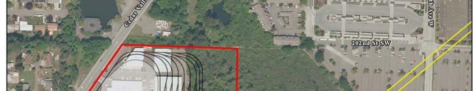
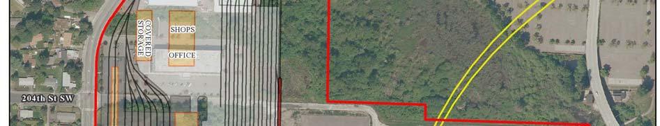
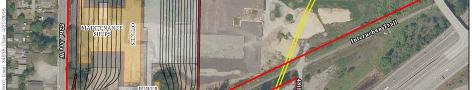
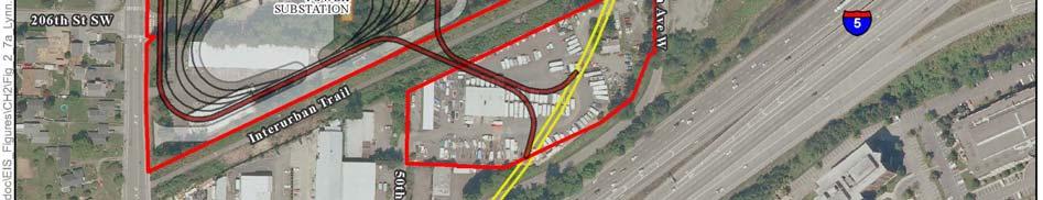
11 Figure 5. Site Plan Lynnwood Alternative Link Light Rail Operations and Maintenance Satellite Facility 6 September 2015


12 Figure 6. Site Plan Lynnwood Alternative (BNSF Storage Tracks) Link Light Rail Operations and Maintenance Satellite Facility 7 September 2015
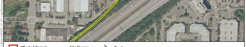
13 Lynnwood Alternative, involving about 24 acres, is bounded on the west by 52nd Avenue W/Cedar Valley Road, on the south by a Pacific Northwest Traction Company right of way, and by private parcels to the north and east. This alternative would acquire about 39 acres. The site is currently occupied by a mix of uses, including office buildings, light industrial buildings, retail stores, and undeveloped land that is planned for future use (i.e., the Edmonds School District s support center, warehouse, and school bus maintenance and storage facility). In addition, the Lynnwood Alternative would require a separate light rail vehicle (LRV) storage area for approximately 32 cars on a site that would require acquisition of 11 acres adjacent to the former BNSF line (now Sound Transit right ofway) located between 116th and 120th Avenues NE at about NE 19th Street in Bellevue. The site plan for the Lynnwood Alternative is shown in Figure 5; the site plan for the BNSF Storage Tracks in Bellevue is shown in Figure 6. REPORT PURPOSE This report presents traffic and access analyses to support the Concept Design Report and environmental review for the Sound Transit Link light rail OMSF. It includes trip generation estimates for the proposed project, traffic operations analyses of automobile access points, and evaluations of potential impacts on safety, transit, and nonmotorized transportation for each of the four build alternatives. INTRODUCTION TO RESOURCES AND REGULATORY REQUIREMENTS As part of each agency s comprehensive planning efforts, agency transportation goals and level of service (LOS) standards are developed. Level of service is a qualitative measure used to characterize traffic operating conditions. Six letter designations, A through F, are used to define level of service. LOS A is the best and represents good traffic operations with little or no delay to motorists. LOS F is the worst and indicates poor traffic operations with long delays. While each agency accepts different levels of congestion, a delay based intersection LOS analysis has been preliminarily accepted by each agency. Delay is expressed in terms of average delay per vehicle, in seconds, experienced during an analysis hour. The LOS standards typically apply to the PM peak hour, which is the hour between 4:00 and 6:00 p.m. when weekday traffic is typically highest for the overall roadway network. The following outlines the LOS standards for the jurisdictions containing the build alternatives. City of Bellevue The City of Bellevue s traffic level of service standards are outlined in its Traffic Standards Code (TSC), which are presented in the Bellevue City Code (BCC) Section Within the City, PM peak period (averaged) level of service standards are tailored for each mobility management area (distinct areas with boundaries based on factors such as area specific mobility target), reflecting distinct conditions and multiple community objectives, with an area average approach used to measure system adequacy. As outlined in BCC section , the average level of service of the system intersections within each area is calculated. There is a congestion allowance specified for each mobility management area that defines the maximum number of system intersections allowed to Link Light Rail Operations and Maintenance Satellite Facility 8 September 2015
14 exceed the area average level of service standard set for a mobility management area. The areaaverage level of service standard and the congestion allowance for the Bel Red/Northup/Area #12 mobility management area (the one that contains the potential OMSF build alternatives) are: Area Average LOS Standard (Maximum volume to capacity ratio) = 0.950; Congestion Allowance = 7 However, it should also be noted that BCC section public transportation facilities are except from the requirements of the Traffic Standards Code. Overall, if a given intersection s operations are better than the LOS standard for each agency with the build alternative, then that intersection is considered to meet the agency s standard and does not require mitigation. In situations where the intersection operates worse than the agency s LOS standard without the build alternative, then mitigation may be required if the City s standards apply to the proposed development and intersection delay and/or LOS degrades further with the build alternative. City of Lynnwood The City s Comprehensive Plan outlines its level of service standard to measure the overall transportation system's ability to move people and goods. Different standards apply for City Center arterials, state facilities, and the rest of the city. The City s LOS standards are as follows: LOS C for local streets at all times. LOS D for State Highways during the PM peak hour based on the Washington State Department of Transportation s (WSDOT s) LOS standard for urban arterials. LOS D for non City Center arterials and non State Highways during the PM peak hour. LOS E for City Center arterials during the PM peak hour. The City of Lynnwood also allows 20% of the City s signalized intersections to be deficient before the LOS concurrency standard is considered to be violated. There are 56 signals currently installed within the City, so a maximum of 11 signalized intersections are allowed to be deficient. STUDY AREA AND ANALYSIS PERIODS The transportation study area for each alternative site was defined based on standard transportation and traffic impact analysis practices as well as the requirements of the two local jurisdictions where the build alternatives are located. The analysis approach and study areas for each site reflect locally adopted impact analysis guidelines. As will be described later, regardless of the site selected, the OMSF is projected to generate lower levels of daily and peak hour traffic than the land uses that would be displaced from each site. Therefore, the project would result in a net decrease in trips on roadways surrounding each of the sites compared to conditions without the OMSF project. As a result, traffic impact analysis standards do not require analysis of off site intersections and the operations analyses were limited to the vehicular site access driveways at each site. Since the OMSF alternatives would not result in new off site impacts, the descriptions of the Affected Environment (including transit, pedestrian, and bicycle facilities) are presented in tabular format rather than on maps. Data required for the site access analyses were compiled from new traffic counts performed at each access location Link Light Rail Operations and Maintenance Satellite Facility 9 September 2015
15 including new daily counts adjacent to each site. For site access, the peak traffic flows would occur early in the morning (4:00 to 5:00 a.m.) and midday (10:30 to 11:30 a.m.) when the largest numbers of LRV operators and maintenance facility employees would arrive and depart the facility. AFFECTED ENVIRONMENT This section presents a summary of existing conditions at each of the alternative sites without the proposed Sound Transit Link light rail OMSF. These are the baseline conditions against which project impacts are evaluated. Preferred Alternative Transportation Network Characteristics of the key roadways and intersections in the vicinity of the Preferred Alternative (BNSF) site, including street classification, speed limits, traffic control, nonmotorized facilities, parking, and other attributes, are summarized in Table 1. Table 1. Summary of Study Area Roadway Characteristics Preferred Alternative Characteristic 120th Avenue NE Street Classification Collector Arterial 1 Speed Limit (mph) 30 Lanes Street Edge Condition Bike Lanes Parking Lane Restrictions Transit Stops Traffic Control and Signal Locations 2 (1 each direction plus lanes added at key intersections) Mostly paved or gravel shoulder with segments of curb, gutter, and sidewalk on west side None Along some segments of gravel shoulder None None Signals at NE 20th St (Northup Way) and NE 12th Street Source: City of Bellevue Arterial Classification Map. March 9. Available: street_classification_a.pdf. The City of Bellevue Transportation Improvement Program (TIP),1 the Capital Investment Program Plan (CIP),2 and the Transportation Facilities Plan: Preliminary Project Priority List (TFP)3 include several projects in the study area that will most likely alter the existing transportation network near the site before the 2035 design year. Several of the projects are listed in more than one plan, but with different identification numbers as noted. 1 City of Bellevue, Adopted May 21, 2012 Resolution No City of Bellevue, City of Bellevue, Approved by the Transportation Commission June 14, Link Light Rail Operations and Maintenance Satellite Facility 10 September 2015
16 120th Avenue NE Improvements (Stage 2 and 3) NE 8th Street to Northup Way (TIP #15, CIP #R 164, TFP #208). This project will extend, realign and widen 120th Avenue NE from NE 8th Street to south of NE 12th Street and widen 120th Avenue NE from south of NE 12th Street to Northup Way (Stage 3). Stage 2 of the project includes all intersection improvements at NE 8th Street and Old Bel Red Road. Stage 3 of the project includes all intersection improvements at NE 12th Street, Northup Way, and an enhanced intersection with the proposed NE 15th Street to accommodate the proposed alignment of Sound Transit's East Link light rail route. The roadway cross section will consist of five lanes, including two travel lanes in each direction with turn pockets or a center turn lane. The project will improve, or install where missing, bike lanes, curb, gutter and sidewalk on both sides, illumination, landscaping, irrigation, storm drainage, and water quality treatment. 120th Avenue NE (stages 3 and 4)/NE 12th Street to 18th Street and to Northup Way (TC #4, Prelim. TFP Map #RI 157, CIP #R 164). Stage 3 will widen 120th Avenue NE from NE 12th Street to NE 16th Street alignment and re profile the roadway in conjunction with Sound Transit s East Link Project. The roadway cross section for stage 3 will consist of five lanes, with two travel lanes in each direction and center turn lane or turn pockets; bike lanes, curb, gutter and sidewalk both sides. Stage 4, from NE 16th Street to Northup Way will widen the roadway and transition from a 5 lane section to a 4 lane section in proximity of NE 18th Street. Stage 4 north of NE 18th Street will consist of two northbound through lanes, a center turn lane and one southbound lane with sidewalks on both sides and separated bike path on west site. NE 15th Street Multi Modal Corridor (Segment I) NE 12th Street to 124th Avenue NE (TIP #14, CIP #R 163, TFP #209). This project will implement a new multi modal corridor consisting of two general purpose travel lanes in each direction; turn lanes at designated intersections; curbs, gutters and sidewalks on both sides; bicycle facilities incorporated within or adjacent to the corridor with regional trail connections; illumination; and storm drainage and detention. Other features may include provisions for local street connections and interim on street parking. Accommodation for light rail guide ways, a light rail station at approximately 121st Avenue NE, and other utility infrastructure needs will be included within the design of the project corridor. The project may also incorporate green elements, including urban open spaces, tree canopy with enhanced landscaping features, and natural drainage elements where practical. The project will modify existing or construct new signalized intersections at 116th Avenue NE, the reconnection of NE 12th Street, 120th Avenue NE, and 124th Avenue NE. Project implementation will be coordinated with existing and potential development, the Sound Transit East Link Project, planned improvements to 120th and 124th Avenues NE, and future NE 15th/16th Street improvements east of 124th Avenue NE. Roadway Traffic Volumes Forty eight hour traffic counts were performed on 120th Avenue NE at approximately the location of the planned primary access driveway on January 22nd and 23rd, Figure 7 shows the average weekday hourly traffic volumes by direction on 120th Avenue NE, which carries an average of about 4,800 vehicles per day. The figure shows a directional traffic pattern on 120th Avenue NE in which peak southbound flows (away from Northup Way and SR 520) occur in the morning and peak northbound flows (toward NE Link Light Rail Operations and Maintenance Satellite Facility 11 September 2015
17 12th Street) occur in the afternoon. The highest volumes on 120th Avenue NE occur between 1:00 and 2:00 p.m. and again between 5:00 and 6:00 p.m. (the midday and PM peak hours, respectively), with about 410 vehicles per hour for both directions. As described later in the Potential Impacts section, OMSFgenerated trips that overlap the commuter AM peak hour would be highest from 7:00 to 8:00 a.m.; during that hour, about 250 vehicles use 120th Avenue NE (85 northbound, 165 southbound). Figure 7. Hourly Traffic Volumes on 120th Avenue NE near the Preferred Alternative Site Total Northbound Southbound :00 AM 1:00 AM 2:00 AM 3:00 AM 4:00 AM Total Number of Vehicles 5:00 AM 6:00 AM 7:00 AM 8:00 AM 9:00 AM 10:00 AM 11:00 AM 12:00 PM 1:00 PM 2:00 PM 3:00 PM 4:00 PM 5:00 PM 6:00 PM 7:00 PM 8:00 PM 9:00 PM 10:00 PM 11:00 PM Source: All Traffic Data Services, Inc., January Existing Site Generated Traffic Volumes The Preferred Alternative site consists of 10 parcels with several buildings that, according to King County Assessor records, contain general office space (58,022 sf), retail space (8,788 sf), and warehouse space (281,353 sf). The site includes four vacant parcels and one parcel used for parking associated with an adjacent Barrier Audi auto dealership that is not part of the Preferred Alternative site. Traffic generated by the existing uses on the site was estimated using standard trip generation rates published in ITE s Trip Generation Manual. Rates published for General Office (Land Use Code 710), Retail Shopping Center (Land Use Code 820), and Warehousing (Land Use Code 150) were applied to each existing use based on the sizes available from the County s Assessor records and listed above. Table 2 presents the trip generation estimates for the existing uses on the site. As shown, the site is estimated to generate 2,020 trips per day, 183 AM peak hour trips, and 209 PM Link Light Rail Operations and Maintenance Satellite Facility 12 September 2015
18 peak hour trips. Table 2. Preferred Alternative Existing Site Trip Generation Estimates Daily AM Peak Hour Trips a PM Peak Hour Trips b Trip Type Size Trips In Out Total In Out Total General Office (LU 710) 58,022 sf General Retail (LU 820) 8,788 sf Warehouse (LU 150) 281,353 sf 1, Total Trips 2, Source: Heffron Transportation, Inc., January 2013 using rates published in ITE s Trip Generation Manual, 9th Edition, a AM Peak Hour typically occurs during one hour between 7:00 and 9:00 a.m. b PM Peak Hour typically occurs during one hour between 4:00 and 6:00 p.m. Traffic Safety Collision data along the site frontage of 120th Avenue NE and its nearest intersections were obtained from WSDOT to determine if there are any traffic safety conditions that could affect or be affected by the OMSF project. Data were obtained for the most recent three year period available, which spanned January 1, 2009 to December 31, Collision data for this period are summarized in Table 3. As shown, the largest number of collisions occurred at the 120th Avenue NE/NE 12th Street intersection. During the three year period, there was an average of 2.3 collisions per year. Of the seven reported collisions, three were listed as rear end collisions. The data indicated that no collisions occurred along the site frontage of 120th Avenue NE. Based on these data, there are no unusual traffic safety conditions in the site vicinity. Table 3. Intersection Collision Summary Preferred Alternative Number of Collisions by Type Intersection Head On Rear End Side Swipe Right Turn Left Turn Right Angle Ped/Bicycle Other 3 Year Total Average/Year 120th Avenue NE/NE 12th Street th Avenue NE/Lowes Dwy a Roadway Segment 120th Avenue NE along site frontage Source: WSDOT, January a Intersection is located about 400 feet north of the Preferred Alternative site. Link Light Rail Operations and Maintenance Satellite Facility 13 September 2015
19 Transit Transit service closest to the Preferred Alternative site is provided by King County Metro. The closest transit stop is located on Northup Way at 120th Avenue NE, approximately one quarter mile north of the site. The stop is served by Metro Route 249, which provides daily service between the South Bellevue Park and Ride lot and the Overlake Transit Center. It operates weekdays from about 6:20 a.m. to about 8:20 p.m. with roughly 30 minute headways (time between consecutive buses). It also operates on Saturdays and Sundays with 45 minute headways.4 Near the Preferred Alternative site, King County Metro owns and operates two bus base facilities for dispatch, operations, maintenance, and storage of transit vehicles on the Eastside. Metro s East Base is located between 120th and 124th Avenues NE at approximately NE 18th Place. Metro s Bellevue Base is located on the east side of 124th Avenue NE south of NE 18th Place. Both the East Base and Bellevue Base have primary access from 124th Avenue NE; however, the East Base has one secondary gated access on 120th Avenue NE. Nonmotorized Facilities There is sidewalk along the western side of 120th Avenue NE for about 1,165 feet south of Northup Way. There is also sidewalk along the west side of the roadway for about 665 feet north of NE 12th Street. There is no sidewalk along the east side or the remainder of the west side (about 2,040 feet) of 120th Avenue NE. There are no other nonmotorized facilities along the roadway. The existing SR 520 Trail is located along the north side of SR 520, connecting the cities of Hunts Point, Yarrow Point, Bellevue, and Redmond. In the vicinity of the build alternative sites, the trail exists along the north side of SR 520 east of Northup Way and continues to Willows Road NE in Redmond. The SR 520 Trail is paved and managed by WSDOT. The Eastside Rail Corridor is a 42 mile long rail corridor between the cities of Renton and Woodinville. The portion of the Eastside Rail Corridor owned by Sound Transit is located adjacent to the Preferred Alternatives (BNSF). The Eastside Rail Corridor is railbanked, which preserves the corridor for reactivation of freight and allows a trail as an interim use. King County is developing a regional trail master plan for the Eastside Rail Corridor, which will consider the combination of a regional trail, high capacity transit, and utility interests in the corridor. The regional trail has not been designed or approved, and funding has not been secured; therefore, it is not included in the list of reasonably foreseeable actions. However, the Preferred Alternative and all other OMSF alternatives are consistent with the shared uses allowed under the corridor s easement provisions and envisioned by the Eastside Rail Corridor Regional Advisory Council (2013), including the return of rail freight or development of a regional trail. King County, the designated interim trail sponsor, is in the process of developing a master plan that will address issues related to the combination of regional trail, high capacity transit, rail, and utility use.5 4 Metro Online Trip Planner, December Regional Advisory Council Creating Connections Recommendations on the Eastside Rail Corridor. October. King County website: advisory council/reports.aspx. Link Light Rail Operations and Maintenance Satellite Facility 14 September 2015
20 The City of Bellevue s 2009 Pedestrian and Bicycle Transportation Plan6 identifies pedestrian and bicycle related policies and projects in the Pedestrian and Bicycle Transportation Facility Plan component of the City s Comprehensive Plan. The City of Bellevue will begin work on a Pedestrian and Bicycle Master Plan in early The following projects, as identified in the 2009 plan, are in the vicinity of the Preferred Alternative site (note that several are also part of the improvements described previously from the City s CIP and TFP). S 214 W and S 214 E: 120th Avenue NE from Bel Red Road to Northup Way Add 8 foot wide sidewalks and 4 foot wide planter strips on both sides of 120th Avenue NE from NE Bel Red Road to Northup Way where not complete. O 104: Burlington Northern Bike Path from southern city limits to northern city limits Add a 10 to 14 foot wide off street path along the BNSF railroad right of way from the southern city limits to the northern city limits. This is part of a proposed regional trail that would connect Eastside communities from Renton to Woodinville. Approximately 7.5 miles of the trail is located in the city of Bellevue. The regional trail shall have connections to pedestrian and nonmotorized city facilities and be compliant with current trail standards. Potential trail connections include Newcastle Beach Park, Greenwich Crest, the I 90 trail, Woodridge, the Wilburton area, downtown Bellevue, Bel Red, NE 15th Street, the West Tributary Trail, and the SR 520 trail. Identified as priority bike corridor NS 3: BNSF Trail Corridor. O 109: West Tributary Trail from the BNSF Corridor to Bel Red Road Add a 10 to 14 foot wide offstreet path along the West Tributary of Kelsey Creek between the BNSF Corridor and Bel Red Road. Provide grade separation of this trail at arterial crossings. O 110 N: NE 16th Street from 116th Avenue NE to 140th Avenue NE Add 10 to 14 foot wide offstreet path along the north side of NE 16th Street from 116th Avenue NE to 140th Avenue NE. Component of priority bike corridor; EW 2: Downtown Overlake Connection. B 119 E and B 119 W: 120th Avenue NE from Northup Way to NE 4th Street Add 5 foot wide bike lanes on both sides of 120th Avenue NE from Northup Way to the NE 4th Street extension. B 110 N and B 110 S: Northup Way from 120th Avenue NE to 124th Avenue NE Add 5 foot wide bike lanes on both sides of Northup Way from 120th Avenue NE to 124th Avenue NE. The Bel Red Subarea Plan7 identifies policies and transportation projects within the subarea to support the major goals and objectives for growth set by the Bellevue City Council. The plan includes improvements to the transportation system, most of which have been incorporated into other plans, to provide better vehicular, transit, and nonmotorized connections within the subarea. 6 City of Bellevue, City of Bellevue, adopted by Ordinance #5858, February 17, Link Light Rail Operations and Maintenance Satellite Facility 15 September 2015
21 The following projects with nonmotorized components identified in the plan are located in the vicinity of the Preferred Alternative site (note that several are also part of the improvements described previously from the City s CIP and TFP). 101: Northup Way between 120th Avenue NE and 124th Avenue NE Five lanes; add eastbound lane, sidewalks both sides, bicycle lanes. 102: Northup Way west of 120th Avenue NE Three lanes, sidewalks both sides, bicycle lanes. 104: 120th Avenue NE Five lanes that connect directly to NE 8th Street on the south; sidewalks both sides, bike lanes both sides, with a connection to the SR 520 Trail on the north. 107: NE 15th/16th Corridor from 116th Avenue NE to 136th Place NE Multi modal corridor, incorporating east/west arterial capacity (two through lanes in each direction, potentially with an interim improvement that would be limited to a single through lane in each direction); light rail guideways and stations; urban sidewalks; a bicycle trail/pathway with regional trail connections; and green elements, including urban open spaces, tree canopy and landscaping features, and natural drainage features where practical. 206: Trail Head Located adjacent to BNSF at Lake Bellevue. Integrates a trailhead with mini park facilities at BNSF regional trail8 and Lake Bellevue. 207: Trail Head Located at the BNSF regional trail corridor and the NE 15th/16th Parkway. Integrates a trailhead with minipark facilities at the crossing of the two major multipurpose trails. Parking Some parallel and 90 degree angle parking occurs along the gravel shoulders on both sides of 120th Avenue NE. Parked vehicles include automobiles as well as large trucks or truck trailers. Off street parking is also provided in lots adjacent to offices, warehouses, and light industrial buildings in the site vicinity. Site Access There are seven existing site access driveways along the west side of 120th Avenue NE that provide access to the parcels east of the former BNSF rail tracks. Freight Mobility and Access Adjacent to the Preferred Alternative site, 120th Avenue NE between Bellevue Redmond Road and Northup Way is classified as a T2 roadway within the FGTS. This means it carries between 4 million and 10 million tons per year. Several industrial and warehouse properties in the area likely generate truck traffic along 120th Avenue NE in the site vicinity. 8 Assumed to be project O 104 from 2009 Pedestrian and Bicycle Transportation Plan Link Light Rail Operations and Maintenance Satellite Facility 16 September 2015
22 BNSF Modified Alternative The background conditions for the BNSF Modified Alternative are nearly identical to those presented previously for the Preferred Alternative. The primary difference between the two alternative sites relates to the parcels that would make up each. The BNSF Modified Alternative would include all but one of the parcels identified for the Preferred Alternative plus eight additional parcels on the west side of the former BNSF right of way. Since the site access locations for the BNSF Modified Alternative site would be the same as those described for the Preferred Alternative site, the conditions described for the Transportation Network, Roadway Traffic Volumes, Safety, Transit, Nonmotorized Facilities, Parking and Site Access are also the same. The one key difference is the Existing Site Generated Traffic, which is described below. Existing Site Generated Traffic Volumes The BNSF Modified Alternative site consists of 17 parcels with numerous buildings that, according to King County Assessor records, contain general office space (55,634 sf), retail space (8,788 sf), and warehouse space (310,665 sf). The site includes three parcels that are used as a fire department training center, four vacant parcels, and one parcel that is used for parking associated with an adjacent Barrier Audi auto dealership that is not part of the BNSF Modified Alternative site. Traffic generated by the existing uses on the site was estimated using standard trip generation rates published in ITE s Trip Generation Manual. Rates published for General Office (Land Use Code 710), Retail Shopping Center (Land Use Code 820), and Warehousing (Land Use Code 150) were applied to each existing use based on the sizes available from the County s Assessor records and listed above. Table 4 presents the trip generation estimates for the existing uses on the site. As shown, the site is estimated to generate 2,100 trips per day, 188 AM peak hour trips, and 215 PM peak hour trips. Table 4. BNSF Modified Alternative Existing Site Trip Generation Estimates Daily AM Peak Hour Trips a PM Peak Hour Trips b Trip Type Size Trips In Out Total In Out Total General Office (LU 710) 55,634 sf General Retail (LU 820) 8,788 sf Warehouse (LU 150) 310,665 sf 1, Total Trips 2, Source: Heffron Transportation, Inc., January 2013, using rates published in ITE s Trip Generation Manual, ninth edition, a AM peak hour typically occurs during one hour between 7:00 and 9:00 a.m. b PM peak hour typically occurs during one hour between 4:00 and 6:00 p.m. SR 520 Alternative Transportation Network Characteristics, such as street classification, speed limits, traffic control, nonmotorized facilities, parking, and other attributes of the key roadways and intersections in the SR 520 Alternative site vicinity are summarized in Table 5. Link Light Rail Operations and Maintenance Satellite Facility 17 September 2015
23 Table 5. Summary of Study Area Roadway Characteristics SR 520 Alternative Characteristic NE 20th Street (Northup Way) 130th Avenue NE 136th Place NE Street Classification Minor Arterial a Collector Arterial a Collector Arterial a Speed Limit (mph) 35 in site vicinity 30 in site vicinity 25 Lanes Street Edge Condition 5 (2 each direction plus center turn lane); turn lanes added at some intersections Curbs, gutters, and sidewalks on both sides 3 (1 each direction plus center turn lane); turn lanes added at some intersections Curbs, gutters, and sidewalks on both sides Bike Lanes None None None 2 Intermittent gravel shoulder; grass ditch, small segments of curb, gutter, and sidewalk Parking None None Along some segments of gravel shoulder Lane Restrictions None None None Transit Stops Traffic Control and Signal Locations Both sides at 136th Place NE, 132nd Avenue NE, and 130th Avenue NE Signals at 130th Ave NE, 132nd Ave NE, 136th Place NE; 140th Ave NE, Block, & 148th Ave NE None Signal at NE 20th Street (Northup Way) None Signal at NE 20th Street (Northup Way) a Source: City of Bellevue Arterial Classification Map; March 9, Available: pdf/it/street_classification_a.pdf. b Highways of Statewide Significance (HSS), designated under RCW , include interstate highways and other principal arterials that are needed to connect major communities in the state. c HOV = high occupancy vehicle. The City of Bellevue Transportation Improvement Program (TIP),9 the Capital Investment Program Plan (CIP),10 and the Transportation Facilities Plan: Preliminary Project Priority List (TFP)11 include several projects in the study area that will likely alter the existing transportation network near the site before the 2035 design year. Several of the projects are listed in more than one plan, but with different identification numbers as noted. Northup Way Corridor Improvements (TIP #8, CIP #R 146, TFP #079). This project will construct bike lane and sidewalk improvements on Northup Way between NE 24th Street and 108th Avenue NE, a center turn lane and planting strips may also be included. This project is a continuation of the City s Northup Way Corridor Study, completed in The proposed improvements on Northup Way will also serve as an a interim regional trail connecting the existing SR 520 trail terminus (near NE 24th Street) to 9 City of Bellevue, Adopted May 21, 2012 Resolution No City of Bellevue, City of Bellevue, Approved by the Transportation Commission June 14, Link Light Rail Operations and Maintenance Satellite Facility 18 September 2015
24 108th Avenue NE where a new regional pedestrian and bicycle path will be built by WSDOT, as part of the SR 520 project. This project is a partnership between the City and WSDOT. This project may also incorporate other work such as fish passage enhancements and culvert replacement, bridge widening, traffic calming, driveway access management, and pedestrian crossings at key locations to be determined during the design phase. NE 15th/16th Street (Phase II)/124th Avenue NE to 136th Place NE and 136th Place NE/NE 16th to 20th Streets (TIP #52, TFP #215). Extend five lane roadway from 124th Avenue NE to 136th Place NE with a key intersection at 130th Avenue NE. Widen 136th Place NE five to three lanes between NE 16th Street and NE 20th Street (reduction occurs at the intersection); add a double westbound left turn on NE 20th Street. 130th Avenue NE/NE 20th to NE Bel Red Road (TIP #55, TFP #218). Construct turn lanes, shared bike lanes, on street parking and sidewalks between NE 16th and NE 20th Streets and widen to three lanes with shared bike lanes and sidewalks between NE 16th Street and Bel Red Road. Key intersections at NE 20th, NE 16th and Bel Red Road. Project implementation will be coordinated with potential future private development in the immediate vicinity. NE 16th Street/130th Avenue NE to 136th Place NE and 136th Place NE/NE 16th to 20th Streets (TC #7, Prelim. TFP Map #RI 135). Construct multimodal corridor from 130th Avenue NE to 132nd Avenue NE. Design as needed for coordination with East Link for segment 132nd Avenue NE to 136th Place and 136th Place to NE 20th Street. Coordinate with East Link, which will bifurcate the eastbound and westbound travel lanes. Project will provide one travel lane in each direction, buffered bike lanes, landscape strip and sidewalk on both sides. 130th Avenue NE/NE 20th to NE Bel Red Road (TC #24, Prelim. TFP Map #RI 137). Initiate design for roadway improvements. Segment NE 20th Street to NE 16th Street to include two travel lanes, bike lanes, on street parking, landscape strip and sidewalks both sides. Segment NE 16th Street to Bel Red Road to include one through lane each direction, center turn lane, landscape strip and sidewalks both sides. Project to be coordinated with Sound Transit East Link. Roadway Traffic Volumes New 48 hour traffic counts were performed on NE 20th Street (Northup Way) west of 136th Place NE on January 22nd and 23rd, Figure 8 shows the average weekday hourly traffic volumes by direction on 120th Avenue NE, which carries an average of about 23,220 vehicles per day. The figure shows a relatively balanced directional traffic pattern on NE 20th Street with eastbound and westbound volumes that are similar throughout the day. The highest volume on NE 20th Street occurs between noon and 1:00 p.m. (midday peak hour) with about 2,090 vehicles per hour in both directions. The PM peak hour volume is slightly lower (1,975 vehicles per hour between 5:00 and 6:00 p.m.); the AM peak hour flow from 7:00 to 8:00 a.m. is about 1,075 vehicles per hour (615 westbound, 460 eastbound). Volume on NE 20th Street are higher during the 8:00 to 9:00 a.m. hour; however, as described later, the OMSF would generate more trips between 7:00 and 8:00 a.m., so the analyses focused on that hour during the morning peak period. Link Light Rail Operations and Maintenance Satellite Facility 19 September 2015
25 Figure 8. Hourly Traffic Volumes on NE 20th Street (Northup Way) near SR 520 Alt. Site Total Eastbound Westbound :00 AM 1:00 AM 2:00 AM Total Number of Vehicles 3:00 AM 4:00 AM 5:00 AM 6:00 AM 7:00 AM 8:00 AM 9:00 AM 10:00 AM 11:00 AM 12:00 PM 1:00 PM 2:00 PM 3:00 PM 4:00 PM 5:00 PM 6:00 PM 7:00 PM 8:00 PM 9:00 PM 10:00 PM 11:00 PM Source: All Traffic Data Services, Inc., January Existing Site Generated Traffic Volumes The SR 520 site consists of 13 parcels with several buildings that, according to King County Assessor records and field observations, contain general office space (224,955 sf), retail space (55,387 sf), automobile sales space (20,639 sf), and automobile care and service space (30,301 sf). Traffic generated by the existing uses on the site was estimated using standard trip generation rates published in ITE s Trip Generation Manual. Rates published for General Office (Land Use Code 710), Retail Shopping Center (Land Use Code 820), Automobile Sales (Land Use Code 841), and Automobile Care (Land Use Code 942) were applied to each existing use based on the sizes available from the County s Assessor records and listed above. Table 6 presents the trip generation estimates for the existing uses on the site. As shown, the site is estimated to generate 6,460 trips per day, 512 AM peak hour trips, and 688 PM peak hour trips. Link Light Rail Operations and Maintenance Satellite Facility 20 September 2015
26 Table 6. SR 520 Alternative Existing Site Trip Generation Estimates Daily AM Peak Hour Trips a PM Peak Hour Trips b Trip Type Size Trips In Out Total In Out Total General Office (LU 710) 224,955 sf 2, General Retail (LU 820) 55,387 sf 2, Auto Sales (LU 841) 20,639 sf Auto Care (LU 942) 30,301 sf Total Trips 6, Source: Heffron Transportation, Inc., January 2013, using rates published in ITE s Trip Generation Manual, ninth edition, a AM peak hour typically occurs during one hour between 7:00 and 9:00 a.m. b PM peak hour typically occurs during one hour between 4:00 and 6:00 p.m. Traffic Safety Collision data along the site frontage of NE 20th Street and its nearest intersections were obtained from WSDOT to determine if there are any traffic safety conditions that could affect or be affected by the OMSF project. Data were obtained for the most recent three year period available, which spanned January 1, 2009 to December 31, Collision data for this period are summarized in Table 7. As shown, the largest number of collisions occurred at the signalized intersection of NE 20th Street and 130th Avenue NE. During the three year period, there was an average of 4.3 collisions per year. Of the 13 reported collisions, 7 were listed as left turn collisions. Given the volume of traffic served along NE 20th Street, the number and type of collisions at the nearby signalized intersections and along the frontage near the planned access location do not indicate any unusual traffic safety conditions. Table 7. Intersection Collision Summary SR 520 Alternative Intersection Head On Rear End Number of Collisions by Type Side Swipe Right Turn Left Turn Right Angle Ped/ Bicycle NE 20th Street/130th Avenue NE a NE 20th Street/136th Avenue NE a Roadway Segment 130th Avenue NE along site frontage NE 20th Street within 500 feet of planned OMSF primary access Source: WSDOT, January a Signalized intersection. Other 3 Year Total Average/Year Link Light Rail Operations and Maintenance Satellite Facility 21 September 2015
27 Transit Transit service closest to the SR 520 Alternative site is provided by King County Metro. The closest transit stop is located on NE 20th Street (Northup Way) at 136th Place NE, adjacent to the site. Stops are also located along NE 20th Street at 132nd Avenue NE and 130th Avenue NE. The stops are served by Metro Route 249, which provides daily service between the South Bellevue Park and Ride lot and the Overlake Transit Center. It operates weekdays from about 6:20 a.m. to about 8:20 p.m. with roughly 30 minute headways (time between consecutive buses). It also operates on Saturdays and Sundays with 45 minute headways.12 Nonmotorized Facilities There is sidewalk along both sides of NE 20th Street (Northup Way) and 130th Avenue NE. Along 136th Place NE, there are short segments of sidewalk; however, most of the roadway does not have sidewalk. There are no other nonmotorized facilities along the roadways near the site. The existing SR 520 Trail is located along the north side of SR 520, connecting the cities of Hunts Point, Yarrow Point, Bellevue, and Redmond. In the vicinity of the build alternative sites, the trail exists along the north side of SR 520 east of Northup Way and continues to Willows Road NE in Redmond. The SR 520 Trail is paved and managed by WSDOT. As described for the Preferred Alternative, the City of Bellevue s 2009 Pedestrian and Bicycle Transportation Plan13 identifies pedestrian and bicycle related policies and projects in the Pedestrian and Bicycle Transportation Facility Plan component of the City s Comprehensive Plan. The following projects identified in the 2009 plan are located in the vicinity the SR 520 Alternative (note that several are also part of the improvements described previously from the City s CIP and TFP). S 201 W and S 201 E: 130th Avenue NE from Northup Way to Bel Red Road Add 8 foot wide sidewalks and 4 foot wide planter strips on both sides of 130th Avenue NE from Northup Way to Bel Red Road where not complete. O 111 E: 132nd Avenue NE from NE 20th Street to Bel Red Road Add a 10 to 14 foot wide offstreet path on the east side of 132nd Avenue NE from NE 20th Street to Bel Red Road. B 111 N and B 111 S: Northup Way/NE 20th Street from 124th Avenue NE to 140th Avenue NE Add 5 foot wide bike lanes on both sides of Northup Way/NE 20th Street from 124th Avenue NE to 140th Avenue NE. Component of priority bike corridor; EW 2: Downtown Overlake Connection. B 113 E and B 113 W: 130th Avenue NE from NE 24th Street to NE 20th Street Add 5 foot wide bike lanes on both sides of 130th Avenue NE from NE 24th Street to NE 20th Street. 12 Metro Online Trip Planner, December Available: 13 City of Bellevue, Link Light Rail Operations and Maintenance Satellite Facility 22 September 2015
28 As described for the Preferred Alternative, the Bel Red Subarea Plan14 identifies policies and transportation projects within the subarea to support the major goals and objectives for growth set by the Bellevue City Council. The following projects with nonmotorized components identified in the plan are located in the vicinity of the SR 520 Alternative (note that several are also part of the improvements described previously from the City s CIP and TFP). 106: 130th Avenue NE Two lanes, pedestrian oriented street north of NE 16th Street, on street parking north of NE 16th Street, three lanes south of NE 16th Street. 108: 136th Place NE Three lanes (two southbound, one northbound), light rail running abovegrade in the median, sidewalks both sides, bike lanes both sides. Parking No parking is permitted along NE 20th Street; however, parallel parking occurs along the gravel shoulders on both sides of 130th Avenue NE and 136th Place NE. Off street parking is also provided in lots adjacent to retail buildings, offices, warehouses, and light industrial buildings in the site vicinity. Site Access There are nine existing site access driveways along the north side of NE 20th Street that provide access to the parcels that make up the SR 520 site; there are two site access driveways long the east side of 130th Avenue NE. All but one of the access driveways are stop sign controlled; the driveway located opposite 136th Place NE is controlled by a traffic signal. Freight Mobility and Access Near the SR 520 Alternative site, NE 20th Street/Northup Way between 116th Avenue NE and 148th Avenue NE is classified as a T2 roadway within the FGTS. This means it carries between 4 million and 10 million tons per year. Several industrial, warehouse, and retail properties in the area likely generate truck traffic along NE 20th Street and Northup Way in the site vicinity. Lynnwood Alternative The following sections describe the transportation network for the Lynnwood study area evaluated as part of the analysis of the Lynnwood Alternative. As described previously, the Lynnwood Alternative would also require development of a LRV overnight storage yard (the BNSF Storage Tracks) in Bellevue. Because the BNSF Storage Tracks site is included within the larger sites being considered for the Preferred Alternative and BNSF Modified Alternative, the transportation network for the Bellevue portion of the Lynnwood Alternative (the BNSF Storage Tracks) is the same as that presented for those alternatives, unless specifically noted in the following sections. Transportation Network Characteristics, such as street classification, speed limits, traffic control, nonmotorized facilities, parking, and other attributes of the key roadways and intersections in the Lynnwood Alternative site vicinity are summarized in Table City of Bellevue, adopted by Ordinance #5858, February 17, Link Light Rail Operations and Maintenance Satellite Facility 23 September 2015
Table of Contents INTRODUCTION... 3 PROJECT STUDY AREA Figure 1 Vicinity Map Study Area... 4 EXISTING CONDITIONS... 5 TRAFFIC OPERATIONS...
 Crosshaven Drive Corridor Study City of Vestavia Hills, Alabama Table of Contents INTRODUCTION... 3 PROJECT STUDY AREA... 3 Figure 1 Vicinity Map Study Area... 4 EXISTING CONDITIONS... 5 TRAFFIC OPERATIONS...
King County Metro. Columbia Street Transit Priority Improvements Alternative Analysis. Downtown Southend Transit Study. May 2014.
 King County Metro Columbia Street Transit Priority Improvements Alternative Analysis Downtown Southend Transit Study May 2014 Parametrix Table of Contents Introduction... 1 Methodology... 1 Study Area...
TRANSPORTATION REVIEW
 TRANSPORTATION REVIEW - PROPOSED MIX OF LAND USES IS CONSISTENT WITH THE CITY S UNDER THE GRANVILLE BRIDGE POLICIES THAT AIM TO MEET NEIGHBOURING RESIDENTS SHOPPING NEEDS AND REDUCE RELIANCE ON AUTOMOBILE
NEWCASTLE MIDDLE SCHOOL Traffic Impact Analysis
 Gibson Traffic Consultants 2802 Wetmore Avenue Suite 220 Everett, WA 98201 425.339.8266 NEWCASTLE MIDDLE SCHOOL Traffic Impact Analysis Prepared for: Renton School District Jurisdiction: City of Newcastle
3.1 Introduction Transportation Elements and Study Area Meeting the Need for the Project
 Chapter 3 Transportation Environment and Consequences 3. Introduction This chapter summarizes the characteristics of the transportation system in the East Link Project vicinity and discusses potential
Link LRT: Maintenance Bases, Vehicles and Operations for ST2 Expansion
 Project Number SYS-LRT Subareas All Primary Mode Impacted Link Facility Type Link Service Version Number 4.0 Date Last Modified 7/24/2008 Project Locator Map Short Project Description Construct new light
APPENDIX C1 TRAFFIC ANALYSIS DESIGN YEAR TRAFFIC ANALYSIS
 APPENDIX C1 TRAFFIC ANALYSIS DESIGN YEAR TRAFFIC ANALYSIS DESIGN YEAR TRAFFIC ANALYSIS February 2018 Highway & Bridge Project PIN 6754.12 Route 13 Connector Road Chemung County February 2018 Appendix
Escondido Marriott Hotel and Mixed-Use Condominium Project TRAFFIC IMPACT ANALYSIS REPORT
 Escondido Marriott Hotel and Mixed-Use Condominium Project TRAFFIC IMPACT ANALYSIS REPORT Prepared for Phelps Program Management 420 Sixth Avenue, Greeley, CO 80632 Prepared by 5050 Avenida Encinas, Suite
2.0 Development Driveways. Movin Out June 2017
 Movin Out June 2017 1.0 Introduction The proposed Movin Out development is a mixed use development in the northeast quadrant of the intersection of West Broadway and Fayette Avenue in the City of Madison.
Lacey Gateway Residential Phase 1
 Lacey Gateway Residential Phase Transportation Impact Study April 23, 203 Prepared for: Gateway 850 LLC 5 Lake Bellevue Drive Suite 02 Bellevue, WA 98005 Prepared by: TENW Transportation Engineering West
TRANSPORTATION TECHNICAL REPORT
 TRANSPORTATION TECHNICAL REPORT for Sunrise Elementary School Replacement PREPARED FOR: Puyallup School District PREPARED BY: 6544 NE 61 st Street, Seattle, WA 98115 ph: (26) 523-3939 fx: (26) 523-4949
TIMBERVINE TRANSPORTATION IMPACT STUDY FORT COLLINS, COLORADO JANUARY Prepared for:
 TIMBERVINE TRANSPORTATION IMPACT STUDY FORT COLLINS, COLORADO JANUARY 2014 Prepared for: Hartford Companies 1218 W. Ash Street Suite A Windsor, Co 80550 Prepared by: DELICH ASSOCIATES 2272 Glen Haven Drive
Citizens Committee for Facilities
 Citizens Committee for Facilities AGENDA Thursday, December 11, 2014 City Council Chambers 305 3 rd Avenue East -Twin Falls, Idaho 11:30 A.M. AGENDA ITEMS Purpose By 1. Discussion and possible action on
TRANSPORTATION TECHNICAL REPORT
 TRANSPORTATION TECHNICAL REPORT for Sartori Elementary School PREPARED FOR: Renton School District PREPARED BY: October 13, 2016 Sartori Elementary School Transportation Technical Report TABLE OF CONTENTS
BROWARD BOULEVARD CORRIDOR TRANSIT STUDY
 BROWARD BOULEVARD CORRIDOR TRANSIT STUDY FM # 42802411201 EXECUTIVE SUMMARY July 2012 GOBROWARD Broward Boulevard Corridor Transit Study FM # 42802411201 Executive Summary Prepared For: Ms. Khalilah Ffrench,
3.0 Transportation Environment and Consequences
 3.0 Transportation Environment and Consequences 3.1 Summary This chapter describes the characteristics of the transportation system in the FWLE vicinity and discusses potential impacts and mitigation measures
Develop ground transportation improvements to make the Airport a multi-modal regional
 Project Overview TRANSPORTATION IMPROVEMENTS WHAT ARE THE PROJECT GOALS? Transportation transportation hub. Develop ground transportation improvements to make the Airport a multi-modal regional Land Use
Table Existing Traffic Conditions for Arterial Segments along Construction Access Route. Daily
 5.8 TRAFFIC, ACCESS, AND CIRCULATION This section describes existing traffic conditions in the project area; summarizes applicable regulations; and analyzes the potential traffic, access, and circulation
Date: February 7, 2017 John Doyle, Z-Best Products Robert Del Rio. T.E. Z-Best Traffic Operations and Site Access Analysis
 Memorandum Date: February 7, 07 To: From: Subject: John Doyle, Z-Best Products Robert Del Rio. T.E. Z-Best Traffic Operations and Site Access Analysis Introduction Hexagon Transportation Consultants, Inc.
ANDERSON PROPERTY SITE ANALYSIS
 ANDERSON PROPERTY SITE ANALYSIS Introduction The Montgomery County Department of Transportation (MCDOT) initiated a feasibility study in the fall of 2012 to evaluate the need for transit service expansion
Sound Transit East Link: Bus/LRT System Integration Study
 Sound Transit East Link: Bus/LRT System Integration Study Prepared For: Sound Transit King County Metro Mercer Island WSDOT Prepared By: CH2M HILL July, 2014 1 SOUND TRANSIT EAST LINK: BUS/LRT SYSTEMES
TRAFFIC IMPACT STUDY. USD #497 Warehouse and Bus Site
 TRAFFIC IMPACT STUDY for USD #497 Warehouse and Bus Site Prepared by: Jason Hoskinson, PE, PTOE BG Project No. 16-12L July 8, 216 145 Wakarusa Drive Lawrence, Kansas 6649 T: 785.749.4474 F: 785.749.734
RTID Travel Demand Modeling: Assumptions and Method of Analysis
 RTID Travel Demand Modeling: Assumptions and Method of Analysis Overall Model and Scenario Assumptions The Puget Sound Regional Council s (PSRC) regional travel demand model was used to forecast travel
Traffic Engineering Study
 Traffic Engineering Study Bellaire Boulevard Prepared For: International Management District Technical Services, Inc. Texas Registered Engineering Firm F-3580 November 2009 Executive Summary has been requested
2. Valley Circle Boulevard/Andora Avenue/Baden Avenue and Lassen Street
 IV.J TRANSPORTATION 1. INTRODUCTION This section presents an overview of the existing traffic and circulation system in and surrounding the project site. This section also discusses the potential impacts
INDUSTRIAL DEVELOPMENT
 INDUSTRIAL DEVELOPMENT Traffic Impact Study Plainfield, Illinois August 2018 Prepared for: Seefried Industrial Properties, Inc. TABLE OF CONTENTS Executive Summary 2 Introduction 3 Existing Conditions
Traffic Impact Analysis West Street Garden Plots Improvements and DuPage River Park Garden Plots Development Naperville, Illinois
 Traffic Impact Analysis West Street Garden Plots Improvements and DuPage River Park Garden Plots Development Naperville, Illinois Submitted by April 9, 2009 Introduction Kenig, Lindgren, O Hara, Aboona,
STH 60 Northern Reliever Route Feasibility Study Report
 #233087 v3 STH 60 Northern Reliever Route Feasibility Study Report Washington County Public Works Committee Meeting September 28, 2016 1 STH 60 Northern Reliever Route Feasibility Study Hartford Area Development
Transportation Technical Report
 Transportation Technical Report Puyallup Station Access Improvements Transportation Technical Report 4 South Jackson Street Seattle, WA 984 2826 February 26 This Page Intentionally Left Blank Puyallup
TRAFFIC SIGNAL DESIGN REPORT KING OF PRUSSIA ROAD & RAIDER ROAD RADNOR TOWNSHIP PENNSYLVANIA
 TRAFFIC SIGNAL DESIGN REPORT KING OF PRUSSIA ROAD & RAIDER ROAD RADNOR TOWNSHIP PENNSYLVANIA PREPARED FOR: UNIVERSITY OF PENNSYLVANIA HEALTH SYSTEM 34 CIVIC CENTER BOULEVARD PHILADELPHIA, PA 1987 (61)
Attachment F Transportation Technical Memorandum
 Attachment F Transportation Technical Memorandum Sounder Yard and Shops Facility Project Transportation Technical Memorandum March 25, 216 Prepared for: Sound Transit Prepared by: Parsons Brinckerhoff
IMPROVEMENT CONCEPTS
 IMPROVEMENT CONCEPTS for the South Novato Transit Hub Study Prepared by: January 11, 2010 DKS Associates With Wilbur Smith Associates IMPROVEMENT CONCEPTS Chapter 1: Introduction 1. INTRODUCTION The strategic
TRAFFIC PARKING ANALYSIS
 TRAFFIC PARKING ANALYSIS NAPA FLEA MARKET COUNTY OF NAPA Prepared for: Tom Harding Napa-Vallejo Flea Market 33 Kelly Road American Canyon, CA 9453 Prepared by: 166 Olympic Boulevard, Suite 21 Walnut Creek,
Madison BRT Transit Corridor Study Proposed BRT Operations Plans
 Madison BRT Transit Corridor Study Proposed BRT Operations Plans This paper presents a description of the proposed BRT operations plan for use in the Madison BRT Transit Corridor Study. The objective is
Corridor Sketch Summary
 Corridor Sketch Summary SR 241: I-82 Jct (Sunnyside) to SR 24 Jct Corridor Highway No. 241 Mileposts: 7.53 to 25.21 Length: 17.65 miles Corridor Description The seventeen and one-half mile corridor begins
Federal Way Link Extension
 Federal Way Link Extension Draft EIS Summary Route & station alternatives and impacts Link Light Rail System Map Lynnwood Mountlake Terrace Lynnwood Link Extension Shoreline 14th Northgate 40 Northgate
2016 PSRC REGIONAL & KING COUNTYWIDE EASTSIDE FUNDING AWARDS. Eastside Transportation Partnership September 9, 2016
 2016 PSRC REGIONAL & KING COUNTYWIDE EASTSIDE FUNDING AWARDS Eastside Transportation Partnership September 9, 2016 1 2 PSRC 2016 Project Selection Process 2018-2020 Estimated FHWA Funds Available: (Summary)
King Soopers #116 Thornton, Colorado
 Traffic Impact Study King Soopers #116 Thornton, Colorado Prepared for: Galloway & Company, Inc. T R A F F I C I M P A C T S T U D Y King Soopers #116 Thornton, Colorado Prepared for Galloway & Company
5. HORIZON YEAR TRANSPORTATION MASTER PLAN-COST ESTIMATES
 5. HORIZON YEAR TRANSPORTATION MASTER PLAN-COST ESTIMATES 5.1 INTRODUCTION This chapter of the TMP presents an opinion of probable cost estimates for the proposed Horizon Year roadway network improvements
Note: The October 2007 version of this report has been updated in this December 2008 report to present costs in year 2007 dollars.
 Sound Transit Phase 2 South Corridor LRT Design Report: SR 99 and I-5 Alignment Scenarios (S 200 th Street to Tacoma Dome Station) Tacoma Link Extension to West Tacoma Prepared for: Sound Transit Prepared
Proposed location of Camp Parkway Commerce Center. Vicinity map of Camp Parkway Commerce Center Southampton County, VA
 Proposed location of Camp Parkway Commerce Center Vicinity map of Camp Parkway Commerce Center Southampton County, VA Camp Parkway Commerce Center is a proposed distribution and industrial center to be
Alpine Highway to North County Boulevard Connector Study
 Alpine Highway to North County Boulevard Connector Study prepared by Avenue Consultants March 16, 2017 North County Boulevard Connector Study March 16, 2017 Table of Contents 1 Summary of Findings... 1
Committee Report. Transportation Committee. Business Item No
 Committee Report Business Item No. 2015-280 Transportation Committee For the Metropolitan Council meeting of December 9, 2015 Subject: METRO Blue Line Extension (Bottineau Light Rail Transit) Revised Scope
Highway 18 BNSF Railroad Overpass Feasibility Study Craighead County. Executive Summary
 Highway 18 BNSF Railroad Overpass Feasibility Study Craighead County Executive Summary October 2014 Highway 18 BNSF Railroad Overpass Feasibility Study Craighead County Executive Summary October 2014 Prepared
Letter EL652 City of Mercer Island. Page 1. No comments n/a
 Letter EL652 City of Mercer Island Page 1 No comments n/a Page 2 Response to comment EL652 1 Section 4.5.3 of the Final EIS presents the range of potential impacts of the project. This project also lists
1. INTRODUCTION 2. PROJECT DESCRIPTION CUBES SELF-STORAGE MILL CREEK TRIP GENERATION COMPARISON
 CUBES SELF-STORAGE MILL CREEK TRIP GENERATION COMPARISON 1. INTRODUCTION This report summarizes traffic impacts of the proposed CUBES Self-Storage Mill Creek project in comparison to the traffic currently
VOA Vista Drive Residential housing Development TIA Project #13915 TABLE OF CONTENTS
 VOA Vista Drive Residential housing Development TIA Project #13915 TABLE OF CONTENTS Executive Summary... 2 Project Background... 2 Conditions... 2 Findings... 3 Recommendations... 4 Introduction... 6
EUGENE-SPRINGFIELD, OREGON EAST WEST PILOT BRT LANE TRANSIT DISTRICT
 EUGENE-SPRINGFIELD, OREGON EAST WEST PILOT BRT LANE TRANSIT DISTRICT (BRIEF) Table of Contents EUGENE-SPRINGFIELD, OREGON (USA)... 1 COUNTY CONTEXT AND SYSTEM DESCRIPTION... 1 SYSTEM OVERVIEW... 1 PLANNING
3.0 Transportation Environment and Consequences
 3.0 Transportation Environment and Consequences 3.1 32BSummary This chapter describes the characteristics of the transportation system in the Federal Way Link Extension (FWLE) vicinity and discusses potential
TRAFFIC IMPACT ANALYSIS SHORTBREAD LOFTS 2009 MODIFICATION Chapel Hill, North Carolina
 TRAFFIC IMPACT ANALYSIS SHORTBREAD LOFTS 2009 MODIFICATION Chapel Hill, North Carolina Prepared for: The Town of Chapel Hill, NC Prepared by: Architects-Engineers-Planners, Inc. November 2009 Traffic Impact
APPENDIX B Traffic Analysis
 APPENDIX B Traffic Analysis Rim of the World Unified School District Reconfiguration Prepared for: Rim of the World School District 27315 North Bay Road, Blue Jay, CA 92317 Prepared by: 400 Oceangate,
4.14 TRANSPORTATION AND CIRCULATION
 4.14 TRANSPORTATION AND CIRCULATION 4.14.1 Summary Table 4.14-1 summarizes the identified environmental impacts, proposed mitigation measures, and residual impacts of the proposed project with regard to
Attachment D Environmental Justice and Outreach
 Attachment D Environmental Justice and Outreach ATTACHMENT D Environmental Justice and Outreach Indicate whether the project will have disproportionately high and adverse impacts on minority or low income
EXECUTIVE SUMMARY. The following is an outline of the traffic analysis performed by Hales Engineering for the traffic conditions of this project.
 EXECUTIVE SUMMARY This study addresses the traffic impacts associated with the proposed Shopko redevelopment located in Sugarhouse, Utah. The Shopko redevelopment project is located between 1300 East and
BARRHAVEN FELLOWSHIP CRC 3058 JOCKVALE ROAD OTTAWA, ONTARIO TRANSPORTATION BRIEF. Prepared for:
 BARRHAVEN FELLOWSHIP CRC 3058 JOCKVALE ROAD OTTAWA, ONTARIO TRANSPORTATION BRIEF Prepared for: Barrhaven Fellowship CRC 3058 Jockvale Road Ottawa, ON K2J 2W7 December 7, 2016 116-649 Report_1.doc D. J.
TRAFFIC IMPACT ANALYSIS. for MILTON SQUARE
 TRAFFIC IMPACT ANALYSIS for MILTON SQUARE US Route 7 Milton, Vermont March 5, 2008 LAMOUREUX & DICKINSON 14 Morse Drive Essex Junction, Vermont 05452 (802) 878-4450 Traffic Impact Assessment EXECUTIVE
Transportation. Background. Transportation Planning Goals. Level of Service Analysis 5-1
 Transportation portion of the city s stormwater utility, and state road and fuel taxes. Background The transportation needs of the City of Lacey and its planning areas are met by a growing multimodal network
Traffic Impact Study Speedway Gas Station Redevelopment
 Traffic Impact Study Speedway Gas Station Redevelopment Warrenville, Illinois Prepared For: Prepared By: April 11, 2018 Table of Contents 1. Introduction... 1 2. Existing Conditions... 4 Site Location...
City of Pacific Grove
 Regional Study Utilizing Caltrans Intersection Evaluation Section 7: City of Pacific Grove s: FIRST STREET AT CENTRAL AVENUE Transportation Agency for Monterey County Prepared by Transportation Agency
TRAFFIC IMPACT ANALYSIS
 TRAFFIC IMPACT ANALYSIS Emerald Isle Commercial Development Prepared by SEPI Engineering & Construction Prepared for Ark Consulting Group, PLLC March 2016 I. Executive Summary A. Site Location The Emerald
7 COMPARATIVE EVALUATION OF ALTERNATIVES
 7 COMPARATIVE EVALUATION OF ALTERNATIVES 7.1 INTRODUCTION This chapter presents the comparative analysis of the four Level 2 build alternatives along with a discussion of the relative performance of the
appendix 4: Parking Management Study, Phase II
 appendix 4: Parking Management Study, Phase II A4-1 A4-2 Eastlake Parking Management Study Final Phase 2 Report Future Parking Demand & Supply January 6, 2017 Submitted by Denver Corp Center III 7900 E.
FINAL. Sound Transit Long-Range Plan Update. Issue Paper S.1: Tacoma Link Integration with Central Link. Prepared for: Sound Transit
 Sound Transit Long-Range Plan Update Issue Paper S.1: Tacoma Link Integration with Central Link Prepared for: Sound Transit Prepared by: Quade & Douglas, Inc. FINAL March 2005 Foreword This issue paper
City of Marina. Regional Roundabout Study Utilizing Caltrans Intersection Control Evaluation Section 4: Transportation Agency for Monterey County
 Regional Roundabout Study Utilizing Caltrans Intersection Control Evaluation Section 4: City of Marina Study Intersections: RESERVATION ROAD AT BEACH ROAD RESERVATION ROAD AT DEFOREST ROAD CARDOZA AVENUE
5. OPPORTUNITIES AND NEXT STEPS
 5. OPPORTUNITIES AND NEXT STEPS When the METRO Green Line LRT begins operating in mid-2014, a strong emphasis will be placed on providing frequent connecting bus service with Green Line trains. Bus hours
Wentzville Parkway South Phase 2 & 2A
 Wentzville Parkway South Phase 2 & 2A Sponsor Wentzville Project No. RB18-000034 Project Type New Road TOTAL FUNDING Phase 2 Total County Sponsor Federal $10,000,000 $8,000,000 $2,000,000 $0 Phase 2A Total
Location Concept Plan Amendment Recommendation Approved 2011 Concept Plan
 Valley Line West LRT Concept Plan Recommended Amendments Lewis Farms LRT Terminus Site Location Concept Plan Amendment Recommendation Approved 2011 Concept Plan Lewis Farms LRT terminus site, 87 Avenue/West
STAFF REPORT # CHANGE OF ZONING
 STAFF REPORT #17-2000-0007 CHANGE OF ZONING PLANNING COMMISSION MEETING DATE: November 16, 2017 (Applicant Provided Materials / Traffic Study = Blue) 1. APPLICATION: A public hearing for an application
June WASHINGTON STATE DEPARTMENT OF TRANSPORTATION Alaskan Way Viaduct and Seawall Replacement Program Seattle, Washington
 DESIGN DEVIATION NOs. 1 & 2 Horizontal Stopping Sight Distance and Shoulder Width Reduction SR 99 S. Holgate St to S. King St. Viaduct Replacement Stage 2 MP 29.89 TO MP 30.78 XL-3237 PIN-809936D June
Attachment E3 Vibration Technical Memorandum
 Attachment E3 Technical Memorandum 77 South Bedford Street Burlington, MA 01803 T 781.229.0707 F 781.229.7939 E jross@hmmh.com W www.hmmh.com TECHNICAL MEMORANDUM To: Alisa Swank, CH2M HILL Jodi Ketelsen,
Craig Scheffler, P.E., PTOE HNTB North Carolina, P.C. HNTB Project File: Subject
 TECHNICAL MEMORANDUM To Kumar Neppalli Traffic Engineering Manager Town of Chapel Hill From Craig Scheffler, P.E., PTOE HNTB North Carolina, P.C. Cc HNTB Project File: 38435 Subject Obey Creek TIS 2022
Evaluation of Renton Ramp Meters on I-405
 Evaluation of Renton Ramp Meters on I-405 From the SE 8 th St. Interchange in Bellevue to the SR 167 Interchange in Renton January 2000 By Hien Trinh Edited by Jason Gibbens Northwest Region Traffic Systems
West Hills Shopping Centre Lowe s Expansion Traffic Impact Study
 West Hills Shopping Centre Lowe s Expansion Traffic Impact Study Prepared for: Armel Corporation January 2015 Paradigm Transportation Solutions Ltd. 22 King Street South, Suite 300 Waterloo ON N2J 1N8
11 October 12, 2011 Public Hearing APPLICANT:
 11 October 12, 2011 Public Hearing APPLICANT: CARING TRANSITIONS PROPERTY OWNER: HARDEE REALTY CORPORATION REQUEST: Conditional Use Permit (motor vehicle rental) STAFF PLANNER: Leslie Bonilla ADDRESS /
6.1 Performance in Meeting Project Goals and Objectives
 Chapter 6 Alternatives Evaluation This chapter evaluates how East Link would meet the project Purpose and Need, and analyzes the benefits, environmental impacts, and cost-effectiveness of the project as
THE CORNERSTONE APARTMENTS TRAFFIC IMPACT STUDY R&M PROJECT NO
 THE CORNERSTONE APARTMENTS SITUATED AT N/E/C OF STAUDERMAN AVENUE AND FOREST AVENUE VILLAGE OF LYNBROOK NASSAU COUNTY, NEW YORK TRAFFIC IMPACT STUDY R&M PROJECT NO. 2018-089 September 2018 50 Elm Street,
Executive Summary. Treasure Valley High Capacity Transit Study Priority Corridor Phase 1 Alternatives Analysis October 13, 2009.
 Treasure Valley High Capacity Transit Study Priority Corridor Phase 1 Alternatives Analysis October 13, 2009 Background As the Treasure Valley continues to grow, high-quality transportation connections
TRAFFIC IMPACT ANALYSIS RIZZO CONFERENCE CENTER EXPANSION FINAL REPORT
 TRAFFIC IMPACT ANALYSIS RIZZO CONFERENCE CENTER EXPANSION Chapel Hill, North Carolina FINAL REPORT Prepared for: The Town of Chapel Hill, NC Prepared by: Architects-Engineers-Planners, Inc. December 2010
IV. ENVIRONMENTAL IMPACT ANALYSIS K.2. PARKING
 IV. ENVIRONMENTAL IMPACT ANALYSIS K.2. PARKING ENVIRONMENTAL SETTING The following analysis summarizes the findings and conclusions of the Traffic Analysis (Traffic Study), prepared by The Mobility Group,
Introduction and Background Study Purpose
 Introduction and Background The Brent Spence Bridge on I-71/75 across the Ohio River is arguably the single most important piece of transportation infrastructure the Ohio-Kentucky-Indiana (OKI) region.
I-820 (East) Project Description. Fort Worth District. Reconstruct Southern I-820/SH 121 Interchange
 Project Description. Fort Worth District. Reconstruct Southern I-820/SH 121 Interchange") I-820 (East) Project Description Fort Worth District Reconstruct Southern I-820/SH 121 Interchange I-820 from approximately 2,000 feet north of Pipeline Road/Glenview Drive to approximately 3,200 feet
I-820 (East) Project Description Fort Worth District Reconstruct Southern I-820/SH 121 Interchange I-820 from approximately 2,000 feet north of Pipeline Road/Glenview Drive to approximately 3,200 feet
Traffic Impact Analysis. Yelm East Gateway Planned Action
 Traffic Impact Analysis Planned Action Yelm, Washington November 2014 Traffic Impact Analysis Project Information Project: Prepared for: Evergreen Pacific Fund, LLC Steve Guidinger 2724 Alki Avenue SW,
2.1 Introduction. Chapter 2 Alternatives Considered
 Chapter 2 Alternatives Considered 2.1 Introduction This chapter describes the alternatives and how they were developed for study in this Final Environmental Impact Statement (EIS). The 2008 Draft EIS evaluated
MONTEREY BAY AQUARIUM RESEARCH INSTITUTE (MBARI) MASTER PLAN UPDATE MOSS LANDING, CALIFORNIA
 MASTER PLAN UPDATE MOSS LANDING, CALIFORNIA") MONTEREY BAY AQUARIUM RESEARCH INSTITUTE (MBARI) MASTER PLAN UPDATE MOSS LANDING, CALIFORNIA TRAFFIC IMPACT ANALYSIS Administrative Draft Report Prepared For Monterey Bay Aquarium Research Institute Moss
MONTEREY BAY AQUARIUM RESEARCH INSTITUTE (MBARI) MASTER PLAN UPDATE MOSS LANDING, CALIFORNIA TRAFFIC IMPACT ANALYSIS Administrative Draft Report Prepared For Monterey Bay Aquarium Research Institute Moss
Energy Technical Memorandum
 Southeast Extension Project Lincoln Station to RidgeGate Parkway Prepared for: Federal Transit Administration Prepared by: Denver Regional Transportation District May 2014 Table of Contents Page No. Chapter
EAST LINK PROJECT. Environmental Scoping Information Report. Seattle to Bellevue to Redmond. September 2006
 SCOPING EAST LINK PROJECT Environmental Scoping Information Report Seattle to Bellevue to Redmond September 2006 CENTRAL PUGET SOUND REGIONAL TRANSIT AUTHORITY TABLE OF CONTENTS Introduction... 2 What
7359 WISCONSIN AVENUE MONTGOMERY COUNTY, MARYLAND
 7359 WISCONSIN MONTGOMERY COUNTY, MARYLAND September 1, 2017 7359 Wisconsin Avenue September 2017 7359 WISCONSIN Local Area Transportation Review Montgomery County, Maryland September 1, 2017 Prepared
TABLE OF CONTENTS EXECUTIVE SUMMARY...1 INTRODUCTION...3 PROJECTED FUTURE GROWTH...3 ROADWAY IMPROVEMENT PROJECTS...4 POTENTIAL FUNDING SOURCES...
 Transportation Impact Fee Study September 2014 TABLE OF CONTENTS EXECUTIVE SUMMARY...1 INTRODUCTION...3 PROJECTED FUTURE GROWTH...3 ROADWAY IMPROVEMENT PROJECTS......4 POTENTIAL FUNDING SOURCES...7 PROPOSED
TALMONT TOWNHOMES MADISON KENNETH SPA TRAFFIC IMPACT STUDY. Sacramento, CA. Prepared For: MBK Homes. Prepared By:
 TALMONT TOWNHOMES MADISON KENNETH SPA TRAFFIC IMPACT STUDY Sacramento, CA Prepared For: MBK Homes Prepared By: KD Anderson & Associates 3853 Taylor Road, Suite G Loomis, California 95650 (916) 660-1555
Construction Realty Co.
 MEMORANDUM TO: FROM : Jeff Pickus Construction Realty Co. Luay R. Aboona, PE Principal 9575 West Higgins Road, Suite 400 Rosemont, Illinois 60018 p: 847-518-9990 f: 847-518-9987 DATE: May 22, 2014 SUBJECT:
MINERVA PARK SITE TRAFFIC IMPACT STUDY M/I HOMES. September 2, 2015
 5500 New Albany Road Columbus, Ohio 43054 Phone: 614.775.4500 Fax: 614.775.4800 Toll Free: 1-888-775-EMHT emht.com 2015-1008 MINERVA PARK SITE TRAFFIC IMPACT STUDY M/I HOMES September 2, 2015 Engineers
Waco Rapid Transit Corridor (RTC) Feasibility Study
 Feasibility Study") Waco Rapid Transit Corridor (RTC) Feasibility Study Chris Evilia, Director of Waco Metropolitan Planning Organization Allen Hunter, General Manager Waco Transit System Jimi Mitchell, Project Manager AECOM
Waco Rapid Transit Corridor (RTC) Feasibility Study Chris Evilia, Director of Waco Metropolitan Planning Organization Allen Hunter, General Manager Waco Transit System Jimi Mitchell, Project Manager AECOM
MILLERSVILLE PARK TRAFFIC IMPACT ANALYSIS ANNE ARUNDEL COUNTY, MARYLAND
 MILLERSVILLE PARK TRAFFIC IMPACT ANALYSIS ANNE ARUNDEL COUNTY, MARYLAND Prepared for: Department of Public Works Anne Arundel County Prepared by: URS Corporation 4 North Park Drive, Suite 3 Hunt Valley,
Service Quality: Higher Ridership: Very Affordable: Image:
 Over the past decade, much attention has been placed on the development of Bus Rapid Transit (BRT) systems. These systems provide rail-like service, but with buses, and are typically less expensive to
EXCEPTION TO STANDARDS REPORT
 EXCEPTION TO STANDARDS REPORT PROJECT DESCRIPTION AND NEED The project is located in Section 6, Township 23 North, Range 9 East and Section 31 Township 24 North, Range 9 East, in the Town of Stockton,
GASOLINE SERVICE STATION 1618, 1622 ROGER STEVENS DRIVE OTTAWA, ONTARIO TRANSPORTATION IMPACT ASSESSMENT. Prepared for:
 GASOLINE SERVICE STATION 1618, 1622 ROGER STEVENS DRIVE OTTAWA, ONTARIO TRANSPORTATION IMPACT ASSESSMENT Prepared for: Invecta Development (Ottawa) Corporation 758 Shanks Height Milton, ON L9T 7P7 May
Capital Metro Downtown Multimodal Station
 Capital Metro Downtown Multimodal Station Stakeholder Briefing December 11, 2015 Agenda 1 2 3 4 5 Project Summary Downtown Station Concept Evaluation 4 th Street Traffic Analysis 5 th Street Traffic Analysis
Bi-County Transitway/ Bethesda Station Access Demand Analysis
 Bi-County Transitway/ Bethesda Station Access Demand Analysis Prepared for: Washington Metropolitan Area Transit Authority Office of Planning and Project Development May 2005 Prepared by: in conjunction
The major roadways in the study area are State Route 166 and State Route 33, which are shown on Figure 1-1 and described below:
 3.5 TRAFFIC AND CIRCULATION 3.5.1 Existing Conditions 3.5.1.1 Street Network DRAFT ENVIRONMENTAL IMPACT REPORT The major roadways in the study area are State Route 166 and State Route 33, which are shown
Subarea Study. Manning Avenue (CSAH 15) Corridor Management and Safety Improvement Project. Final Version 1. Washington County.
 Corridor Management and Safety Improvement Project. Final Version 1. Washington County.") Subarea Study Manning Avenue (CSAH 15) Corridor Management and Safety Improvement Project Final Version 1 Washington County June 12, 214 SRF No. 138141 Table of Contents Introduction... 1 Forecast Methodology
Subarea Study Manning Avenue (CSAH 15) Corridor Management and Safety Improvement Project Final Version 1 Washington County June 12, 214 SRF No. 138141 Table of Contents Introduction... 1 Forecast Methodology