Received June 2, 2017 PLN-PUDC
|
|
|
- Mitchell Rudolf Caldwell
- 6 years ago
- Views:
Transcription
 468-6800 Received PLN-PUDC-2016-008 page")
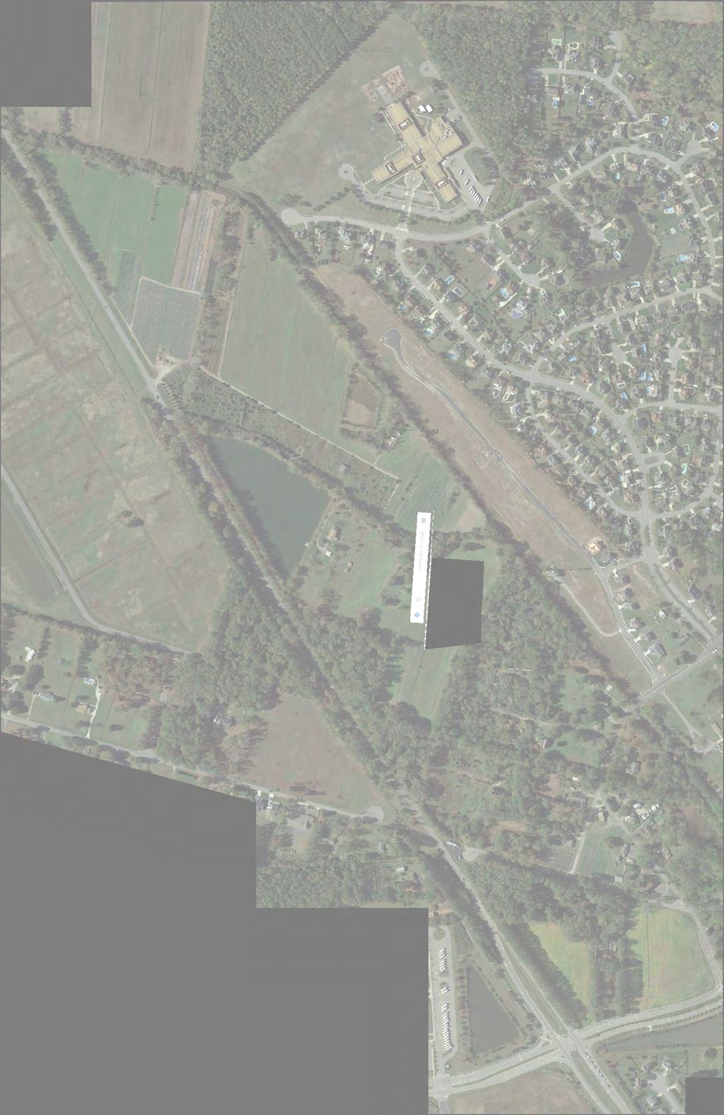
1 MASTER LAND USE PLAN for: a prestigious community presented by: Breeden Investment Properties and Davenport Management Company Virginia Beach, Virginia 23452(757) Received PLN-PUDC page 1 of 15
 DOMINION BLVD DOMINION BOULEVARD HIGH SCHOOL DOMINION COMMERCE PARK PROPOSED LAND USE PLAN LEGEND MF: APARTMENTS (W GARAGES) AH: TOWNHOUSES SF5: SINGLE FAMILY (5,000 SF) SF8:")
2 DEER CROSSING SF8 SF5 RD THE LANDINGS AT BALD CYPRESS QUAY THE MEADOWS AT BALD CYPRESS QUAY DOMINION COMMONS MARSH CREEK ELEMENTARY AVERILL DRIVE LINDSAY CANAL GREEN SEA TRL PROPOSED CEDAR RD SOUTHWEST EXT (122' RW) DOMINION BLVD DOMINION BOULEVARD HIGH SCHOOL DOMINION COMMERCE PARK PROPOSED LAND USE PLAN LEGEND MF: APARTMENTS (W GARAGES) AH: TOWNHOUSES SF5: SINGLE FAMILY (5,000 SF) SF8: SINGLE FAMILY (8,000 SF) B/C: BUSINESS/COMMERCIAL RC: RECREATION/CONSERVATION SW: STORMWATER CONTEXT PLAN NORTH page 2 of 15
 AH: TOWNHOUSES LINDSAY CANAL")
 RD SF5: SINGLE FAMILY (5,000 SF)")


3 LAND USE PLAN LEGEND MF: APARTMENTS (W GARAGES) AH: TOWNHOUSES LINDSAY CANAL PROPOSED CEDAR RD SOUTHWEST EXT (122' RW) RD SF5: SINGLE FAMILY (5,000 SF) SF8: SINGLE FAMILY (8,000 SF) BC: BUSINESS/COMMERCIAL** RC: RECREATION/CONSERVATION SW: STORMWATER LAND USE AS PROPOSED BY THE CONFLUENCE PUD LAND USE COMPARISON PLAN LAND USE PER COUNCIL - ADOPTED DOMINION BOULEVARD CORRIDOR PLAN NORTH page 3 of 15
4 LAND USE PLAN LEGEND: CYPRES Use Type Units Ac DBCS UNITS DBCS Ac MF: APARTMENTS (W GARAGES) 292 units 20.6 Ac Ac ROBERTS LIFE ESTATE PARCEL (TP ) AH: TOWNHOUSES 50 units 8.3 Ac Ac MARSH SF5: SINGLE FAMILY (5,000 SF) 152 units 35.9 Ac Ac CREEK SF8: SINGLE FAMILY (8,000 SF) 50 units 24.8 Ac (INC. IN 124) (INC. in 25) Total Residential Units: 544 units 531 units RD BC: BUSINESS/COMMERCIAL Ac 87,529 SF 9 Ac RC: RECREATION/CONSERVATION Ac** Ac SW: STORMWATER Ac Ac APPROXIMATE AREA OF ANALYSIS 119 Ac 119 Ac GREEN SEA TRL ** OF WHICH 16.9 ACRES ARE LOCATED IN THE RESIDENTIAL DISTRICTS ELEMENTARY AVERILL DRIVE LINDSAY CANAL PROPOSED CEDAR RD SOUTHWEST EXT SF5 (122' RW) UST * SF8 DOMINION BLVD * NOTE: FINAL CLOSURE OF UNDERGROUND STORAGE TANK (UST) TO BE REQUIRED PRIOR TO ANY CONSTRUCTION. OVERALL PLAN HIGH SCHOOL NORTH page 4 of 15
 MARSH 152 units CREEK 35.9 Ac 124 25 Ac SF8: SINGLE FAMILY (8,000 SF) 50 units 24.8 Ac (INC. IN 124) (INC.")
5 LAND USE PLAN LEGEND: CYPRES Use Type Units Ac DBCS UNITS DBCS Ac MF: APARTMENTS (W GARAGES) 292 units 20.6 Ac Ac ROBERTS LIFE ESTATE PARCEL (TP ) AH: TOWNHOUSES 50 units 8.3 Ac Ac SF5: SINGLE FAMILY (5,000 SF) MARSH 152 units CREEK 35.9 Ac Ac SF8: SINGLE FAMILY (8,000 SF) 50 units 24.8 Ac (INC. IN 124) (INC. in 25) Total Residential Units: 544 units 531 units BC: BUSINESS/COMMERCIAL Ac 87,529 SF 9 Ac RD BC RC: RECREATION/CONSERVATION Ac** Ac SW: STORMWATER Ac Ac APPROXIMATE AREA OF ANALYSIS 119 Ac 119 Ac ** OF WHICH 16.9 ACRES ARE LOCATED IN THE RESIDENTIAL DISTRICTS ELEMENTARY AVERILL DRIVE LINDSAY CANAL SF5 GREEN SEA TRL PROPOSED CEDAR RD SOUTHWEST EXT (122' RW) SF5 RC AH MF OVERALL PLAN SF8 SF8 DOMINION BLVD (Recreation/Conservation areas internal to other Land Use areas not shown) HIGH SCHOOL NORTH page 5 of 15
6
7 SC CEDAR RD WC CEDAR ROAD A A1 W2 B B1 S2 CG C C1 RD G1 W3 SD See Sections on Attached Exhibit "Initial Access Street Sections" GW G2 RIGHT-OF-WAY LEGEND EXISTING ROW PROPOSED ROW EDGE OF PAVEMENT I4 I3 I2 WI I1 INITIAL ACCESS CONFIGURATION EXHIBIT DOMINION BOULEVARD NORTH page 7 of 15
 1 Southbound Lane 1 Southbound Left-Turn Lane 2 Northbound Lanes INITIAL ACCESS STREET SECTIONS 4' Sidewalk 2 Eastbound Lanes 1 Westbound Lane")
8 4' Sidewalk West Road Section B-B1 Variable Width Public R.O.W. Proposed Existing Existing Existing Existing 1 Westbound Lane 1 Eastbound Lane Church Parking Lot Cedar Road Section A-A1 Existing Variable Width Public R.O.W. Existing Proposed Future (post-life Estate) 1 Southbound Lane 1 Southbound Left-Turn Lane 2 Northbound Lanes INITIAL ACCESS STREET SECTIONS 4' Sidewalk 2 Eastbound Lanes 1 Westbound Lane Grassfield Road Section C-C1 Variable Width Public R.O.W. These Roadway Sections are intended to show generally the laneage and section elements (lanes, walks, paths, street trees, etc.) and are subject to design refinement during the Final Construction Plan stage, as approved by the Director of Development & Permits or designee. page 8 of 15
9 SC WC W2 S2 CEDAR RD W3 CEDAR RD SW EXT CG RD G1 GW G2 SD RIGHT-OF-WAY LEGEND PROPOSED ROW PROPOSED CEDAR ROAD EXTENSION ROW EDGE OF PAVEMENT I4 I3 I2 WI I1 ULTIMATE ACCESS CONFIGURATION EXHIBIT DOMINION BOULEVARD NORTH page 9 of 15


10
 PHASE B PHASE A DOMINION BOULEVARD 24\" WM SERVICE AREA BOUNDARY BETWEEN PS #235 & PS #248 SUBJECT TO REFINEMENT.")
11 8" SS 12" WM 12" SFM AT BALD CYPRESS QUAY MARSH CREEK PHASE B PHASE A 24" WM 24" HRSD SFM RD 8" SS PS #235 GREEN SEA TRL 16" WM ELEMENTARY AVERILL DRIVE PHASE B PHASE C LINDSAY CANAL PROPOSED CEDAR RD SOUTHWEST EXT (122' RW) PHASE B PHASE A DOMINION BOULEVARD 24" WM SERVICE AREA BOUNDARY BETWEEN PS #235 & PS #248 SUBJECT TO REFINEMENT. UTILITY PLAN LEGEND EXISTING WATER MAIN PROPOSED WATER MAIN (WM) EXISTING SANITARY SEWER FACILITY PROPOSED SANITARY SEWER FACILITY (SS) EXISTING STORM FACILITY PROPOSED STORM FACILITY SOUTHEAST SIDE OF EXISTING LINDSAY CANAL TO BE WIDENED TO 1/2 OF ULTIMATE 35' BOTTOM WIDTH PER CITY'S MASTER DRAINAGE PLAN ALONG ENTIRE FRONTAGE OF PUD. PHASE C PHASE B DOMINION BLVD WATER AND SEWER PHASING: PHASE A: EXTEND 8" GRAVITY SEWER W ON CEDAR AND S ON WEST. UPGRADE PS#248 AS REQUIRED. EXTEND 12" WATER SW FROM WEST, ALONG COLLECTOR ROAD, TO PHASE LIMITS. NOTE: OTHER WATER AND SEWER MAINS WILL BE PROVIDED IN ALL STREETS: THEY HAVE BEEN OMITTED FOR CLARITY. UTILITIES & DRAINAGE PLAN HIGH SCHOOL Virginia Beach, Virginia 23452(757) BACKBONE WM TO BE STUBBED TO DOMINION RW FOR CONNECTION TO FUTURE WATER TRANSMISSION MAIN. PROVIDE PARALLEL 20' EASEMENT FOR FUTURE SEWER FM (BY OTHERS). PHASE B: EXTEND 8" GRAVITY SEWER AND 8" WATER OUT OF CUMBERLAND FARMS, UNDER LINDSAY CANAL, ALONG COLLECTOR ROAD TO PHASE LIMITS. UPGRADE PS #235 AS REQUIRED. PHASE C: EXTEND 8" GRAVITY SEWER AND 12" WATER SW ALONG COLLECTOR ROAD TO PROJECT LIMITS. NORTH page 11 of 15
12 61' BC to BC 24' Drive Aisle These Roadway Sections are intended to show generally the laneage and section elements (lanes, walks, paths, street trees, etc.) and are subject to design refinement during the Final Construction Plan stage, as approved by the Director of Development & Permits or designee. Typical Road Section Multi-Family Private Drives and Parking 18' 5' Sidewalk 5' Planting Area TYPICAL STREET SECTIONS page 12 of 15
13 31' BC to BC Rear loaded Lot 5' Landscape Easement* 4' Sidewalk 4'-6" Verge 4'-6" Verge 4' Sidewalk 5' Landscape Easement* * These Roadway Sections are intended to show generally the laneage and section elements (lanes, walks, paths, street trees, etc.) and are subject to design refinement during the Final Construction Plan stage, as approved by the Director of Development & Permits or designee. 20' 25' 25' Front loaded garage with Proposed 50' R/W Typical Right-of-Way Section 50' Public R.O.W. door recessed from main front plane of house TYPICAL STREET SECTIONS page 13 of 15
14 50' Public R.O.W. 41' BC to BC Rear loaded Lot 5' Landscape 4' Easement* Sidewalk 4'-6" Verge 4'-6" Verge 4' Sidewalk 5' Landscape Easement* * These Roadway Sections are intended to show generally the laneage and section elements (lanes, walks, paths, street trees, etc.) and are subject to design refinement during the Final Construction Plan stage, as approved by the Director of Development & Permits or designee. 30' 30' Proposed 60' R/W Typical Right-Of-Way Section 60' Public R.O.W. 20' Front loaded garage with door recessed from main front plane of house TYPICAL STREET SECTIONS page 14 of 15
15 85' BC to BC 10' Multi-Use Path 10' Verge (min)* 25' 30' Proposed 122' R/W 25' 10' Verge 5' Sidewalk 10' Enhanced Buffer Yard "C" Vinyl Privacy Fence *Path may depart from 10' relationship and follow independent alignment within easement as generally shown on Open Space & Trails Plan. Cedar Road Southwest Extension 122' Public R.O.W. 32' Buffer Vinyl Privacy Fence TYPICAL STREET SECTIONS 20' Enhanced Buffer Yard "C" These Roadway Sections are intended to show generally the laneage and section elements (lanes, walks, paths, street trees, etc.) and are subject to design refinement during the Final Construction Plan stage, as approved by the Director of Development & Permits or designee. 12' R.O.W Reservation Dominion Boulevard (existing Public R.O.W.) Proposed Road Improvements along Confluence Property Line page 15 of 15
PUBLIC INFRASTRUCTURE PROJECTS
 PUBLIC INFRASTRUCTURE PROJECTS FM 664 / OVILLA ROAD WIDENING & IMPROVEMENTS FM 664 / OVILLA ROAD CONNECTS US 287 WITH I-45 (SOURCE: TEXAS DEPARTMENT OF TRANSPORTATION. 2016 FM 664 / OVILLA ROAD WIDENING
City of Houston Fondren Road Paving and Drainage
 City of Houston Fondren Road Paving and Drainage From Braeswood Boulevard to Creekbend Drive TRC Meeting March 2016 Location and Vicinity Maps City Council District K Key Map 530 Z, 530 Y Land Use Commercial
CONCEPTUAL UTILITY REPORT FOR THE CANYONS PHASE 1 CITY OF CASTLE PINES, CO
 CONCEPTUAL UTILITY REPORT FOR THE CANYONS PHASE 1 CITY OF CASTLE PINES, CO PREPARED FOR: SHEA HOMES 9380 STATION ST., SUITE 600 LONE TREE, CO 80124 PHONE: 303-791-8180 CONTACT: RYAN MCDERMED PREPARED BY:
TABLE OF CONTENTS EXECUTIVE SUMMARY...1 INTRODUCTION...3 PROJECTED FUTURE GROWTH...3 ROADWAY IMPROVEMENT PROJECTS...4 POTENTIAL FUNDING SOURCES...
 Transportation Impact Fee Study September 2014 TABLE OF CONTENTS EXECUTIVE SUMMARY...1 INTRODUCTION...3 PROJECTED FUTURE GROWTH...3 ROADWAY IMPROVEMENT PROJECTS......4 POTENTIAL FUNDING SOURCES...7 PROPOSED
A13 AVILA RANCH DEVELOPMENT PLAN SITE PLAN. Typical 58 R-1 Residential Street Section STREET SECTION. July 19, 2016 #
 STREET SECTION SITE PLAN Typical 58 R-1 Residential Street Section 0 4 8 16 SCALE: 1 =8 (24 x36 sheet) A13 STREET SECTION SITE PLAN Typical 60 Collector Street Section 0 4 8 16 SCALE: 1 =8 (24 x36 sheet)
BOARD OF SUPERVISORS BUSINESS MEETING ACTION ITEM. Design Endorsement for Sterling Boulevard Extension
 Date of Meeting: July 20, 2017 # 6 BOARD OF SUPERVISORS BUSINESS MEETING ACTION ITEM SUBJECT: ELECTION DISTRICT: CRITICAL ACTION DATE: STAFF CONTACTS: Design Endorsement for Sterling Boulevard Extension
Transportation Analysis. Pedestrian Pathways. Sterling District. County Project Manager: Suheili Pérez-Jiménez. Prepared by: J2 Engineers, Inc.
 Transportation Analysis Pedestrian Pathways Prepared for: Loudoun County Department of Transportation and Capital Infrastructure County Project Manager: Suheili Pérez-Jiménez Prepared by: J2 Engineers,
ARTICLE 8 OFF-STREET PARKING AND PRIVATE DRIVEWAY STANDARDS
 ARTICLE 8 OFF-STREET PARKING AND PRIVATE DRIVEWAY STANDARDS TABLE OF CONTENTS SECTION PAGE 8.1 GENERAL STANDARDS...8-2 8.2 PRIVATE DRIVEWAY PROVISIONS...8-4 8.3 OFF-STREET PARKING STANDARDS...8-5 8.4 OFF-STREET
November 1, Mr. Jafar Tabrizi President, Tabrizi Rugs 180 Bedford Highway. Traffic Impact Statement BH-1 and BH-2, Southgate Drive, Bedford, NS
 161-12598 Mr. Jafar Tabrizi President, Tabrizi Rugs 180 Bedford Highway Bedford, NS B4A 1C1 [Via Email: tabrizi@tabrizi.com] RE: Traffic Impact Statement Dear Mr. Tabrizi: Plans are being prepared for
747 ACRES LAND FOR SALE
 747 ACRES LAND FOR SALE 3400 NORTH PONY EXPRESS PARKWAY, EAGLE MOUNTAIN, UTAH 84005 Salt Lake Count y Lehi 73 Sar atoga Spring s Eagle Mountain Blvd g Eagle Mountain Eagle Mountain Blvd Pony Express Pkwy
Big Easy RV & Boat Storage A Green Energy Project Jana Lane Wildomar, California
 Big Easy RV & Boat Storage A Green Energy Project 36215 Jana Lane Wildomar, California 1 PROJECT OVERVIEW Project Description The construction and operation of a solar generation facility consisting of
Section III Transportation and Stormwater Projects Receiving Additional Funding Project Detail Sheets Alphabetical Listing by Project Name Five Year
 Section III Transportation and Stormwater Projects Receiving Additional Funding Project Detail Sheets Alphabetical Listing by Project Name Five Year Capital Improvement Plan FY2015/2016 through FY2020
/ Planning and Zoning Staff Report Lonestar Land, LLC. - Rezone, RZ
 / Planning and Zoning Staff Report Lonestar Land, LLC. - Rezone, RZ2018-0019 Hearing Date: October 18, 2018 Development Services Department Applicant: Lonestar Land, LLC. Representative: Lance Warnick
DR SE WAY SOMERSIDE. C-N Neighborhood Commercial Site. R-LD - Development in accordance. Fully Landscaped Park/ Playground.
 LAND & BUSINESS SUPPORT DEPT Southlands Phase 6A Plan 01231 City of Medicine Hat Land & Business Support Ph (03) 52-1 Fax (03) 502-055 land_properties@medicinehat.ca updated August 20, 201 SOMERSET BAY
DESIGN STANDARDS SECTION DS 3 STREETS
 DESIGN STANDARDS SECTION DS 3 STREETS DS 3-01 GENERAL: A. INTENT: The intent of these Design Standards is to provide minimum standards for the design of public streets. These standards are intended to
DRAFT Design Study Report February 2015 Eagle River Traffic Mitigation Phase 1 MOA Project No Appendix D Utilities
 Appendix D Utilities This page intentionally left blank. Utilities There are numerous utilities present within the project area, including natural gas, sewer, water, electric, communications, and street
Technical Memorandum. To: From: Date: October 14 th, 2018 Project #: 1302 Project Name: Subject: Distribution:
 Technical Memorandum To: Tom Hanrahan Jeff Sharp From: Date: October 14 th, 2018 Project #: 1302 Project Name: Subject: Distribution: Barrie Lockhart Road LP Conformity Review Scott Young Sorbara Group
TRAFFIC MANAGEMENT STANDARDS CITY OF GARLAND TRANSPORTATION DEPARTMENT
 TRAFFIC MANAGEMENT STANDARDS CITY OF GARLAND TRANSPORTATION DEPARTMENT JUNE 1996 TABLE OF CONTENTS 1.0 Street Design Standards 1.1 Right-of-Way Requirements 1.2 Median Openings 1.3 Sidewalks 1.4 Traffic
Oaks Commerce Center
 Mansour Edlin Consulting 1515 Mockingbird Lane Charlotte, NC 28209 Oaks Commerce Center Water & Sanitary Sewer Improvements Phase I - Concept Utility Plan Gravity Sanitary Sewer A1 Connect to Existing
Workshop Agenda. Bransford Roundabout. Bedford Intersection/Roundabout. Section 3 Revisions (Left turn lanes) Roadway Section/Curb Type Discussion
 Roadway Section/Curb Type Discussion") Workshop Agenda Bransford Roundabout Bedford Intersection/Roundabout Section 3 Revisions (Left turn lanes) Roadway Section/Curb Type Discussion Project Phasing Summary of Recommendation Purpose: Provide
Workshop Agenda Bransford Roundabout Bedford Intersection/Roundabout Section 3 Revisions (Left turn lanes) Roadway Section/Curb Type Discussion Project Phasing Summary of Recommendation Purpose: Provide
4131 Chain Bridge Road
 Traffic Impact Study 4131 Chain Bridge Road City of Fairfax, VA 05/04/16 May 4, 2016 Prepared for: Paradigm 1415 North Taft Street Suite 100 Arlington, VA 22201 This report is printed on environmentally
ANN ARBOR CITY NOTICE ORDINANCE NO. ORD OFF STREET PARKING CHAPTER 59
 ANN ARBOR CITY NOTICE ORDINANCE NO. ORD-12-04 OFF STREET PARKING CHAPTER 59 AN ORDINANCE TO AMEND SECTIONS 5:168 AND 5:169 OF CHAPTER 59 (OFF- STREET PARKING) OF TITLE V OF THE CODE OF THE CITY OF ANN
5. HORIZON YEAR TRANSPORTATION MASTER PLAN-COST ESTIMATES
 5. HORIZON YEAR TRANSPORTATION MASTER PLAN-COST ESTIMATES 5.1 INTRODUCTION This chapter of the TMP presents an opinion of probable cost estimates for the proposed Horizon Year roadway network improvements
Public Works. Capital Projects FY
 Public Works Capital Projects FY 2015-17 Projects Completed FY 2014 All Done Projects! Residential and Collector Street Paving Lower Westside Arterial Street Rehab: Front, River St South, Soquel Hwy 1
Purpose: General Provisions:
 10-19-1 Purpose: The purpose of off-street parking requirements is to promote traffic/pedestrian safety and efficiency and to minimize hard surfaced areas to reduce storm water run-off and visual impacts
City of Marina. Regional Roundabout Study Utilizing Caltrans Intersection Control Evaluation Section 4: Transportation Agency for Monterey County
 Regional Roundabout Study Utilizing Caltrans Intersection Control Evaluation Section 4: City of Marina Study Intersections: RESERVATION ROAD AT BEACH ROAD RESERVATION ROAD AT DEFOREST ROAD CARDOZA AVENUE
Plan Check Policies and Guidelines
 VIII. TRAFFIC SIGNING AND STRIPING PLANS A. INTRODUCTION Traffic signing and striping plans are required for all General Plan Roads and any roadway that is 56-foot wide curb-to-curb (78 R/W) or wider.
The Eastern Connector Study November, 2007 planning for the future
 The Eastern Connector Study November, 2007 planning for the future In late 2006, Albemarle County and the City of Charlottesville jointly initiated the Eastern Connector Corridor Study. The Project Team
Parking Areas and Driveways for Single and Two Family Dwellings
 Building Information BURNABY PLANNING AND BUILDING DEPARTMENT Parking Areas and Driveways for The purpose of this brochure is to explain to owners, designers and builders the parking and driveway requirements
Crestmont Development Update 2017 AGM
 Crestmont Development Update 2017 AGM West Crestmont West Crestmont Will be built in phases finally reaching about 524 residential units. Rough grading for phases 9 & 10 already underway. First show home
THORNTON ROAD WIDENING PROJECT NO. PW1428 B I D D I N G S C H E D U L E
 THORNTON ROAD WIDENING PROJECT NO. PW1428 B I D D I N G S C H E D U L E Each bidder shall bid each item of the Base Bid Schedule and Alternate A Bid Schedule. Failure to bid an item shall be just cause
SECTION 830 "T-P" - TRAILER PARK RESIDENTIAL DISTRICT
 SECTION 830 "T-P" - TRAILER PARK RESIDENTIAL DISTRICT The "T-P" Trailer Park Residential District is created to provide for the accommodation of residential trailers at a standard consistent with the protection
Plan Check Policies and Guidelines
 Plan Check Policies and Guidelines VII. A. INTRODUCTION Traffic signing and striping plans are required for all General Plan Roads and any roadway that is 56-foot wide curb-to-curb (78 R/W) or wider. Transportation
Location Concept Plan Amendment Recommendation Approved 2011 Concept Plan
 Valley Line West LRT Concept Plan Recommended Amendments Lewis Farms LRT Terminus Site Location Concept Plan Amendment Recommendation Approved 2011 Concept Plan Lewis Farms LRT terminus site, 87 Avenue/West
ARTICLE 7 OFF-STREET PARKING AND LOADING/UNLOADING 7.02 OFF STREET PARKING AND LOADING SPACE REQUIREMENTS
 ARTICLE 7 OFF-STREET PARKING AND LOADING/UNLOADING 7.01 STORAGE IN FRONT YARD Nothing in this Ordinance shall permit the storage or parking of any vehicle or non-permanent structure within the required
Assisted Living / Memory Care - South Forsyth
 ! Assisted Living / Memory Care - South Forsyth LOCATION: 6388 Post Road, Cumming, GA 30040 - Forsyth County Parcel ID - 037-012 2 nd District, 1 st Section, Land Lot 317 SIZE: 5.4723 acres +/- ZONING:
2.0 Development Driveways. Movin Out June 2017
 Movin Out June 2017 1.0 Introduction The proposed Movin Out development is a mixed use development in the northeast quadrant of the intersection of West Broadway and Fayette Avenue in the City of Madison.
SOUTHERN GATEWAY. Transportation and Trinity River Project Committee 11 May 2015
 SOUTHERN GATEWAY Transportation and Trinity River Project Committee 11 May 2015 Southern Gateway Project History Began in 2001 as a Major Investment Study [ MIS ], Schematic, and Environmental Assessment
11 October 12, 2011 Public Hearing APPLICANT:
 11 October 12, 2011 Public Hearing APPLICANT: CARING TRANSITIONS PROPERTY OWNER: HARDEE REALTY CORPORATION REQUEST: Conditional Use Permit (motor vehicle rental) STAFF PLANNER: Leslie Bonilla ADDRESS /
Public Works Department, Capital Improvement Program Project Tracking
 Community Facilities Name CF-01 Eastshore State Park/Powell Street Bioswale Seeking grant funding. TT CF-02 South Bayfront Bridge and Horton Landing Park CF-03 / - 04 Transit Center Updated plans are being
800 Access Control, R/W Use Permits and Drive Design
 Table of Contents 801 Access Control... 8-1 801.1 Access Control Directives... 8-1 801.2 Access Control Policies... 8-1 801.2.1 Interstate Limited Access... 8-1 801.2.2 Limited Access... 8-1 801.2.3 Controlled
Environmental Assessment Derry Road and Argentia Road Intersection
 Air and Noise Study Environmental Assessment Derry Road and Argentia Road Intersection Project 11-4295 City of Mississauga, Region of Peel October 17, 2014 1 Region of Peel Environmental Assessment for
Traffic Engineering Study
 Traffic Engineering Study Bellaire Boulevard Prepared For: International Management District Technical Services, Inc. Texas Registered Engineering Firm F-3580 November 2009 Executive Summary has been requested
CHAPTER 2 ZONING AND DEVELOPMENT
 2.200 GENERAL DEVELOPMENT STANDARDS CHAPTER 2 ZONING AND DEVELOPMENT Section 2.201 GENERAL PROVISIONS... 2.2-1 Section 2.202 FENCES AND VISIONS CLEARANCE... 2.2-2 2.202.01 Fences... 2.2-2 2.202.02 Vision
FEASIBILITY REPORT. 65 th STREET TRUNK WATER MAIN IMPROVEMENTS INVER GROVE HEIGHTS MINNESOTA DAKOTA COUNTY. October 2, 2017
 FEASIBILITY REPORT 65 th STREET TRUNK WATER MAIN IMPROVEMENTS INVER GROVE HEIGHTS MINNESOTA DAKOTA COUNTY October 2, 2017 Prepared for: City of Inver Grove Heights 8150 Barbara Avenue Inver Grove Heights,
Volume 1 Traffic Impact Analysis Turtle Creek Boulevard Dallas, Texas. Kimley-Horn and Associates, Inc. Dallas, Texas.
 Volume 1 Traffic Impact Analysis 2727 Dallas, Texas June 18, 2018 Kimley-Horn and Associates, Inc. Dallas, Texas Project #064523000 Registered Firm F-928 Traffic Impact Analysis 2727 Dallas, Texas Prepared
6.16 OFF-STREET PARKING AND LOADING REQUIREMENTS
 6.16 OFF-STREET PARKING AND LOADING REQUIREMENTS 6.16.1 Off-Street Parking Off-street parking and loading spaces shall be required for all land uses as set forth in this section. A. Minimum Parking Space
Article 10 Parking and Loading Standards
 Article 10 Parking and Loading Standards Sec. 10.1 Purpose The purpose of this Article is to establish the number of required off-street vehicular parking spaces so as to provide for the needs of occupants,
Project Description: Georgia Department of Transportation Public Information Open House Handout PI#(s): , County: Muscogee
: , County: Muscogee") Why We Are Here: GDOT s Transportation Improvement Act (TIA) Office, the City of Columbus, and the project delivery team are here this evening to display and answer questions concerning the proposed roadway
Why We Are Here: GDOT s Transportation Improvement Act (TIA) Office, the City of Columbus, and the project delivery team are here this evening to display and answer questions concerning the proposed roadway
Capital Improvement Plan Review
 City of Manhattan Beach Public Works Department Fiscal Year 2014/2015 2018/2019 Capital Improvement Plan Review Community Meeting: April 10, 2014 Objectives Creating the Capital Improvement Plan Funding
STANDARD DRAWING INDEX
 ATTACHMENT B STANDARD DRAWING INDEX DESCRIPTION EXISTING DRAWING NO. GENERAL Typical Layout for Improvement Plans City of Stockton Standard Border and Title Block for 8 1/2 x11 Sheet City of Stockton Standard
Traffic Impact Analysis Update
 Willow Bend Traffic Impact Analysis Update TABLE OF CONTENTS Page I. INTRODUCTION -------------------------------------------------------------------------------------------- 1 II. EXISTING CONDITIONS
ZEV COHEN & ASSOCIATES. INC. Main Office: Ormond Beach St. Augustine Amelia Island Edgewater
 ZEV COHEN & ASSOCIATES. INC. Main Office: Ormond Beach St. Augustine Amelia Island Edgewater 300 Interchiange Blvd., Suite C Ormond Beach, FL 32174 386-677-2482 Fax: 386-677-2505 Website: www.zevcohen.com
COPPER RUN PRELIMINARY PLANS FOR LITTLE CREEK HUNDRED, KENT COUNTY DELAWARE COPPER RUN GENERAL NOTES. DATA COLUMN PyA FgA SITE.
 PRELIMINARY PLANS FOR LITTLE CREEK HUNDRED, KENT COUNTY DELAWARE DATA COLUMN PyA FgA GENERAL NOTES N SITE N FaA N LOCATION MAP SCALE: 1"=000' SITE SOILS MAP SCALE: 1"=00' TRIP GENERATION - FORK BRANCH
IMPROVEMENT CONCEPTS
 IMPROVEMENT CONCEPTS for the South Novato Transit Hub Study Prepared by: January 11, 2010 DKS Associates With Wilbur Smith Associates IMPROVEMENT CONCEPTS Chapter 1: Introduction 1. INTRODUCTION The strategic
2.303 OFF-STREET PARKING AND LOADING
 CITY OF KEIZER DEVELOPMENT BULLETIN 2.303 OFF-STREET PARKING AND LOADING 2.303.01 Purpose The purpose of this Section is to provide standards to ensure adequate areas for the parking, maneuvering, loading
OFF-STREET PARKING AND LOADING REQUIREMENTS
 ARTICLE XVI. OFF-STREET PARKING AND LOADING REQUIREMENTS Section 221: Definitions The words and phrases defined below shall have the meaning indicated when used in this section, unless otherwise specifically
5.12. DOWNTOWN AREA INFILL INCENTIVE DISTRICT (IID)
") 5.12. DOWNTOWN AREA INFILL INCENTIVE DISTRICT (IID) UNIFIED DEVELOPMENT CODE: 5.12.1 Purpose 5.12.1. PURPOSE The primary purpose of the Downtown Area Infill Incentive District (IID) is to encourage redevelopment
5.12. DOWNTOWN AREA INFILL INCENTIVE DISTRICT (IID) UNIFIED DEVELOPMENT CODE: 5.12.1 Purpose 5.12.1. PURPOSE The primary purpose of the Downtown Area Infill Incentive District (IID) is to encourage redevelopment
Marion County Board of County Commissioners
 Marion County Board of County Commissioners Office of the County Engineer 412 SE 25th Ave. Ocala, FL 34471 Phone: 352-671-8686 Fax: 352-671-8687 DEVELOPMENT REVIEW COMMITTEE WAIVER REQUEST FORM Date: 08/04/2016
LOTUS RANCH TRAFFIC IMPACT ANALYSIS. LLG Ref Senior Transportation Engineer & Charlene Sadiarin Transportation Engineer II
 TRAFFIC IMPACT ANALYSIS LOTUS RANCH El Centro, California July 31, 2015February 12, 2016 LLG Ref. 3-14-2392 Prepared by: KC Yellapu, P.E Senior Transportation Engineer & Charlene Sadiarin Transportation
TOWN OF MARANA, ARIZONA LAND DEVELOPMENT CODE
 TITLE 22 OFF-STREET PARKING AND LOADING SECTIONS: 22.000 Purpose 22.010 When required 22.020 Size and access requirements 22.030 Number of spaces required for designated uses 22.050 Parking areas-development
5 VAUGHAN METROPOLITAN CENTRE AND SURROUNDING AREAS TRANSPORTATION STUDY PROGRESS
 5 VAUGHAN METROPOLITAN CENTRE AND SURROUNDING AREAS TRANSPORTATION STUDY PROGRESS The Transportation Services Committee recommends the adoption of the recommendations contained in the following report
Article 6: Off Street Parking and Loading Standards. Table of Contents. page
 Article 6: Off Street Parking and Loading Standards Table of Contents page Sec. 601 Purpose of Article 6.... 6-1 Sec. 602 Off-street parking; when required.... 6-1 Sec. 603 Number of parking spaces required....
STAFF REPORT # CHANGE OF ZONING
 STAFF REPORT #17-2000-0007 CHANGE OF ZONING PLANNING COMMISSION MEETING DATE: November 16, 2017 (Applicant Provided Materials / Traffic Study = Blue) 1. APPLICATION: A public hearing for an application
CAPITAL FUND 9510 STREET & SIDEWALK IMPROVEMENTS FIVE-YEAR CAPITAL IMPROVEMENT PROGRAM FISCAL YEARS
 9510 STREET & SIDEWALK IMPROVEMENTS FIVE-YEAR CAPITAL IMPROVEMENT PROGRAM FISCAL YEARS 2019-2023 9510 STREET & SIDEWALK IMPROVEMENTS - 01 STREET AND SIDEWALK MAINTENANCE PROGRAM $1,250,000 $0 $1,250,000
ALEXANDRIA, VIRGINIA PRINCE ST. SUITE 114. ADG, INC. COPYRIGHT c. PH
 1600 PRINCE ST. SUITE 114 ALEXANDRIA, VIRGINIA 22314 PH. 703.549.9556 www.archdesigngroup.com ADG, INC. COPYRIGHT c C-1 1 2 3 4 5 6 E D Tie Prop. Sidewalk, Curb & Gutter Into Existing Prop. Storm Drain
ARTICLE PARKING, LOADING AND DRIVEWAYS Effective May 6, 2009
 ARTICLE 10.00 PARKING, LOADING AND DRIVEWAYS Effective May 6, 2009 Section 10.1. Purpose Off-street parking and loading shall be provided in all districts in accordance with the provisions herein at the
Construction Staging Area 4 Avenue Road
 REPORT FOR ACTION Construction Staging Area 4 Avenue Road Date: September 27, 2017 To: Toronto and East York Community Council From: Acting Director, Transportation Services, Toronto and East York District
Cleary Rd and Belvedere Rd West Palm Beach, FL Great Centralized PB County location. Easy access to I-95 and Fl. Turnpike
 and Belvedere Rd For more information contact: John Hoecker, CCIM, CPM, CSM President 5613668424 John@JupiterRealtyCompany.com Great Centralized PB County location. Easy access to I-95 and Fl. Turnpike
p5-7, C-G-2, C - Public Entrance is not defined. What happens with this requirement if there is no sidewalk?
 1 Recode Public Hearing Draft December 2018 Office of Redevelopment 01/02/2019 General Note: Review Index for alignment issues. Article 1, p 1-3, the term expiration provisions of this Code for variances
CHECKLIST CONDITIONAL USE PERMIT APPLICATION Authority: New Castle Municipal Code & et seq.
 Administration Department (970) 984-2311 Fax: (970) 984-2716 www.newcastlecolorado.org Town of New Castle PO Box 90 450 W. Main Street New Castle, Co 81647 CHECKLIST CONDITIONAL USE PERMIT APPLICATION
Charter Township of Plymouth Zoning Ordinance No. 99 Page 164 Article 15: VP Vehicular Parking District Amendments:
 Charter Township of Plymouth Zoning Ordinance No. 99 Page 164 PURPOSE ARTICLE XV VP VEHICULAR PARKING DISTRICT Vehicular Parking Districts (VP) are designed to accommodate off-street parking for the exclusive
NORTHWEST HIGHWAY S-CURVE PEDESTRIAN/BICYCLE ACCESS FEASIBILITY STUDY. Northwest Highway (US 14) From Seegers Road to Western Avenue
 From Seegers Road to Western Avenue") NORTHWEST HIGHWAY SCURVE PEDESTRIAN/BICYCLE ACCESS FEASIBILITY STUDY Northwest Highway (US 14) From Seegers Road to Western Avenue Northwest Highway SCurve Pedestrian/Bicycle Access Feasibility Study City
NORTHWEST HIGHWAY SCURVE PEDESTRIAN/BICYCLE ACCESS FEASIBILITY STUDY Northwest Highway (US 14) From Seegers Road to Western Avenue Northwest Highway SCurve Pedestrian/Bicycle Access Feasibility Study City
BEN WILSON STREET CORRIDOR STUDY
 BEN WILSON STREET CORRIDOR STUDY Prepared for: Victoria MPO Prepared by: FREESE AND NICHOLS, INC. In association with CivilCorp, LLC Ben Wilson Street Corridor Study Victoria MPO TABLE OF CONTENTS EXECUTIVE
Trans-Canada Highway and McCallum Road Interchange Upgrade
 Trans-Canada Highway and McCallum Road Interchange Upgrade A Value Added Project Prepared by: Cory Clark, P.Eng. Project Engineer ISL Engineering and Land Services Suite 301, 20338-65 th Avenue Langley,
M I D - C O A S T REGIONAL PLANNING COMMISSION 166 SOUTH MAIN STREET, SUITE 201 ROCKLAND, ME (207)
") M I D - C O A S T REGIONAL PLANNING COMMISSION 166 SOUTH MAIN STREET, SUITE 201 ROCKLAND, ME 04841 (207) 594-2299 Appropriate access management of municipal roadways can enhance safety, maintain roadway
M I D - C O A S T REGIONAL PLANNING COMMISSION 166 SOUTH MAIN STREET, SUITE 201 ROCKLAND, ME 04841 (207) 594-2299 Appropriate access management of municipal roadways can enhance safety, maintain roadway
West Rosslyn Development
 Traffic Impact Study and Transportation Management Plan West Rosslyn Development Arlington County, VA Revised: January 11, 2017 May 10, 2016 Prepared for: Penzance 2400 N Street, NW, Suite 600 Washington,
Appendix 5. Haymeadow Interim Traffic Analysis
 Appendix 5 Haymeadow Interim Traffic Analysis 20 MEMORANDUM To: From: Rick Pylman Gary Brooks Bill Fox Date: September 15, 2016 Project: Subject: Haymeadow Evaluation of interim access configuration Currently
I-820 (East) Project Description. Fort Worth District. Reconstruct Southern I-820/SH 121 Interchange
 Project Description. Fort Worth District. Reconstruct Southern I-820/SH 121 Interchange") I-820 (East) Project Description Fort Worth District Reconstruct Southern I-820/SH 121 Interchange I-820 from approximately 2,000 feet north of Pipeline Road/Glenview Drive to approximately 3,200 feet
I-820 (East) Project Description Fort Worth District Reconstruct Southern I-820/SH 121 Interchange I-820 from approximately 2,000 feet north of Pipeline Road/Glenview Drive to approximately 3,200 feet
BID FORM PART A. Total Quantity 1 LS $ - 2a Surveying, Layout, and Field Staking 1 LS $ - 2b Maintenance of Traffic 1 LS $ -
 BID FORM PART A Name & Category Unit Unit Cost (B) Cost (AxB) GENERAL REQUIREMENTS 1 Mobilization (Maximum 3.0% of the total Contract Price) 1 LS $ - 2a Surveying, Layout, and Field Staking 1 LS $ - 2b
DISTRICT. Regional Commercial (RC) Light Industrial (LI) No maximum. maximum. 60 acres. Smaller areas may be added to an existing RC area.
 Light Industrial (LI) No maximum. maximum. 60 acres. Smaller areas may be added to an existing RC area.") 7-16-4. Table 2, Table of Standards.,, and Special Purpose Districts. TOOELE CITY, UTAH TABLE 2 TABLE OF STANDARDS MIXED USE, COMMERCIAL, INDUSTRIAL AND SPECIAL PURPOSE S s Maximum Lot Area maximum 25,000
7-16-4. Table 2, Table of Standards.,, and Special Purpose Districts. TOOELE CITY, UTAH TABLE 2 TABLE OF STANDARDS MIXED USE, COMMERCIAL, INDUSTRIAL AND SPECIAL PURPOSE S s Maximum Lot Area maximum 25,000
MUNCIPAL WORK PROGRAMS FY 2015/ /20. MPO Transportation Improvement Program 2015/ /20 Page 9-1
 MUNCIPAL PROGRAMS BELLEAIR 2000 Curb/Sidewalk 35 2001 Roadway Projects 2,500 = ; = Local Funds 35 MPO Transportation Improvement Program 2015/16 2019/20 Page 9-1 MUNCIPAL PROGRAMS BELLEAIR BEACH 3000 Resurface/curb
Appendix A-M Public Information Centre 4 Materials
 Appendix A-M Public Information Centre 4 Materials NOTICE OF PUBLIC INFORMATION CENTRE #4 RAPID TRANSIT CORRIDORS MASTER PLAN ENVIRONMENTAL ASSESSMENT STUDY The City of London is entering a new chapter
Appendix A ILLUSTRATIONS
 Appendix A ILLUSTRATIONS Part 1 - BUILDINGS Part 2 - LOTS Part 3 - PARKING Part 4 - SCREENING Part 5 - SETBACKS/YARDS Appendix 1 Appendix 2 Part 1 BUILDINGS Appendix 3 Appendix 4 FIGURE 1.1 ATTACHED DWELLINGS
FREQUENTLY ASKED QUESTIONS
 THE PROJECT Last updated on 2/19/16 FREQUENTLY ASKED QUESTIONS What s happening on Highway 169? The Minnesota Department of Transportation (MnDOT) is planning to rebuild and repair the infrastructure on
West LRT Lewis Estates to Downtown Concept Plan
 West LRT Lewis Estates to Downtown Concept Plan March 2011 We re moving forward. Learn more. On January 19, 2011, City Council approved the West LRT Concept Plan, with a modification to use Meadowlark
2 MAJOR MACKENZIE DRIVE WEST JOG ELIMINATION AT HUNTINGTON ROAD CITY OF VAUGHAN
 2 MAJOR MACKENZIE DRIVE WEST JOG ELIMINATION AT HUNTINGTON ROAD CITY OF VAUGHAN The Transportation Services Committee recommends the adoption of the recommendations contained in the following report dated
OFF STREET PARKING AND LOADING
 CHAPTER 12-20 OFF STREET PARKING AND LOADING 12-20-101 Purpose and Objectives 12-20-102 General 12-20-103 Parking Design Standards 12-20-104 Street Access 12-20-105 Parking Areas, Development and Maintenance
RESOLUTION NO NOW, THEREFORE, BE IT RESOLVED BY THE MAYOR AND COMMON COUNCIL OF THE TOWN OF PRESCOTT VALLEY, ARIZONA, AS FOLLOWS:
 RESOLUTION NO. 1873 A RESOLUTION OF THE MAYOR AND COMMON COUNCIL OF THE TOWN OF PRESCOTT VALLEY, A MUNICIPAL CORPORATION OF ARIZONA, APPROVING A PLAN, POLICY OR PROCEDURE IN ACCORDANCE WITH ARS 9-471(O)
BID TABULATION REPORT McKINNEY STREET DRAINAGE IMPROVEMENTS PROJECT No. PWDR10012 BID OPENED : TUESDAY, AUGUST 13, :00 P.M.
 PAVING IMPROVEMENTS McKINNEY 101 Rightofway Preparation LS 1 75,000.00 75,000.00 200,000.00 200,000.00 67,000.00 67,000.00 110,000.00 110,000.00 102 12inch HMAC Street Pulvermix SY 11,650 3.00 34,950.00
MANHATTAN VILLAGE ENHANCEMENT PROJECT
 MANHATTAN VILLAGE ENHANCEMENT PROJECT Traffic & Parking Analysis Manhattan Beach City Council September 2013 Study Area and Analyzed Intersections Intersection LOS Results Project Improvements Dedicate
ARLINGTON COUNTY, VIRGINIA
 ARLINGTON COUNTY, VIRGINIA County Board Agenda Item Meeting of April 24, 2004 DATE: April 14, 2004 SUBJECT: Arlington Boulevard (U.S. 50) Bridge Deck Replacement at Washington Boulevard - Overhead Utility
TRAFFIC IMPACT ANALYSIS SHORTBREAD LOFTS 2009 MODIFICATION Chapel Hill, North Carolina
 TRAFFIC IMPACT ANALYSIS SHORTBREAD LOFTS 2009 MODIFICATION Chapel Hill, North Carolina Prepared for: The Town of Chapel Hill, NC Prepared by: Architects-Engineers-Planners, Inc. November 2009 Traffic Impact
Lompa Ranch North Specific Plan
 Lompa Ranch North Specific Plan Photo Credit: aroundcarson.com Prepared by: Updated: January 4, 26 Job # 27- LOMPA RANCH NORTH SPECIFIC PLAN Prepared for: Blackstone Development Group 49 W. Plumb Lane
2405 Mer Bleue Orleans, (Ottawa), ON Community Transportation Study Mattamy Homes. Prepared By: Stantec Consulting Ltd. Version 2
, ON Community Transportation Study Mattamy Homes. Prepared By: Stantec Consulting Ltd. Version 2") 2405 Mer Bleue Orleans, (Ottawa), ON Community Transportation Study Mattamy Homes Prepared By: Stantec Consulting Ltd. Version 2 April 2014 Stantec Consulting Ltd. 400-1331 Clyde Avenue, Ottawa ON K2C
2405 Mer Bleue Orleans, (Ottawa), ON Community Transportation Study Mattamy Homes Prepared By: Stantec Consulting Ltd. Version 2 April 2014 Stantec Consulting Ltd. 400-1331 Clyde Avenue, Ottawa ON K2C
City of Georgetown, Texas. Southeast Inner Loop Schematic Design: IH 35 to Rockride Lane (CR 110) Preliminary Engineering Report
 Preliminary Engineering Report") City of Georgetown, Texas Southeast Inner Loop Schematic Design: IH 35 to Rockride Lane (CR 110) Preliminary Engineering Report Prepared by Kasberg, Patrick and Associates, LP Consulting Engineers, Texas
City of Georgetown, Texas Southeast Inner Loop Schematic Design: IH 35 to Rockride Lane (CR 110) Preliminary Engineering Report Prepared by Kasberg, Patrick and Associates, LP Consulting Engineers, Texas
Off-Street-Parking Requirements. A. General Provisions.
 16-5-07 Off-Street-Parking Requirements A. General Provisions. 1. Floor Area. The term floor area, for the purpose of calculating the number of Off- Street-Parking Spaces required shall be determined on
Project Name: Allstate Utility Construction Rezone. Case Number: P Hearing Date: February 6, City of Mesa.
 Project Name: Allstate Utility Construction Rezone Case Number: P17-0176 Hearing Date: February 6, 2018 City of Mesa GERMANN RD 196TH PL 196TH WAY ALAMOSA DR 196TH ST Project Site 19 7T H ST La LA Jara
INDUSTRIAL DEVELOPMENT SITE DLH PARCEL #34 +/ GROSS ACRES DLH PARCELS #114 & #115 +/ GROSS ACRES
 INDUSTRIAL DEVELOPMENT SITE DLH PARCEL #34 +/- 55.39 GROSS ACRES DLH PARCELS #114 & #115 +/- 133.36 GROSS ACRES YOUR GATEWAY TO GLOBAL DISTRIBUTION LANCASTER-HUTCHINS ROAD HUTCHINS, TEXAS DLH PARCEL #34
ARTICLE XX OFF STREET PARKING AND LOADING REQUIREMENTS
 20 200 Zoning 20 200 ARTICLE XX OFF STREET PARKING AND LOADING REQUIREMENTS Wherever a building or structure is erected, enlarged or capacity increased, or the use is changed in any zoning district, improved