Traffic and Parking Study for an Athletic Recreation Center Janes Avenue Shopping Plaza Site Woodridge, Illinois
|
|
|
- June Parks
- 6 years ago
- Views:
Transcription


1 Traffic and Parking Study for an Athletic Recreation Center Janes Avenue Shopping Plaza Site Woodridge, Illinois N 83 rd Street Janes Avenue Soccer Fields Janes Avenue Shopping Plaza Cypress Cove Family Aquatic Park Janes Avenue Prepared For: Prepared By: March 31, 2014
2 Contents List of Figures and Tables, iii 1. Introduction Existing Conditions...3 Site Location...3 Roadway System Characteristics...3 Existing Traffic Volumes...4 Public Transportation Athletic Recreation Center Development...7 Development Plan...7 Site Accessibility, Parking and Circulation...7 Programming Space...8 Hours of Operation...8 Peak Periods of Activity...8 Peak Employment Levels...9 Directional Distribution of ARC-Generated Traffic...9 ARC Traffic Generation...9 ARC Traffic Assignment Projected Future Traffic Conditions Traffic Analysis Parking Analysis Compliance with Woodridge Zoning Regulations...21 Parking Supply and Demand...22 Parking Demand Reduction Strategies...23 Parking Overflow Accommodations Conclusions and Recommendations...24 Appendix Athletic Recreation Center Traffic and Parking Study ii
3 List of Figures and Tables Figures 1. Site Location Aerial View of Site Area Existing Roadway Characteristics Existing Traffic Volumes Directional Distribution of ARC-Generated Traffic ARC-Generated Traffic Volumes without Multi-Use Gym Addition ARC-Generated Traffic Volumes with Multi-Use Gym Addition Projected Future Traffic Volumes without Multi-Use Gym Addition Projected Future Traffic Volumes with Multi-Use Gym Addition Recommended Janes Avenue Pavement Marking Plan...26 Tables 1. Directional Distribution of ARC-Generated Traffic Traffic Generated by the ARC Level of Service Criteria Capacity Analysis Existing Traffic Conditions Capacity Analysis Projected Future Traffic Conditions ARC Parking Requirements by Zoning Projected Peak Parking Demand...22 Athletic Recreation Center Traffic and Parking Study iii
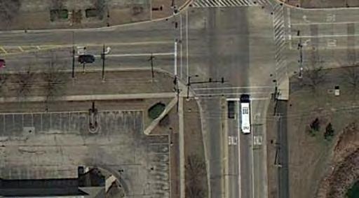
4 1. Introduction This report presents the methodologies, findings, and recommendations of a Traffic and Parking Study conducted by Kenig, Lindgren, O Hara, Aboona, Inc. (KLOA, Inc.) for the Woodridge Park District s planned Athletic Recreation Center (ARC) on the Janes Avenue Shopping Plaza site at the northeast corner of Janes Avenue and 83 rd Street in Woodridge, Illinois. The site is bounded by the Janes Avenue soccer fields on the north, the Piers II condominium community on the east, 83 rd Street on the south, and Janes Avenue on the west. Figure 1 shows the site location and Figure 2 shows an aerial view of the site area. The Janes Avenue Shopping Plaza will be razed and the plaza s existing driveways (two on Janes Avenue and one on 83 rd Street) will be closed. The Janes Avenue soccer fields parking lot and driveways will also be removed. An approximately 77,930 gross square-foot, two-story ARC building (85,030 gross square feet with multi-use gymnasium addition) will be built on the property containing a gymnasium, turf field, health and fitness facility, track, program rooms, and administrative space. Site ingress and egress will provided from two new driveways on Janes Avenue. The ARC will be supported by a 286-space parking lot (306 spaces with multi-use gymnasium addition) that will be shared with the Janes Avenue soccer fields immediately north of the site. The anticipated ARC grand opening is in October The purpose of this study was to (1) examine existing traffic conditions adjacent to the site, (2) quantify the traffic generation from the planned ARC and assess the impact that the facility would have on traffic conditions adjacent to the site, (3) review site circulation, (4) evaluate site parking supply and demand, and (5) determine any roadway or access improvements necessary to accommodate the ARC-generated traffic and enhance the overall plan. Athletic Recreation Center 1 Traffic and Parking Study


5 Figure 1 Site Location Site 83 rd Street Janes Avenue Figure 2 Aerial View of Site Area Athletic Recreation Center 2 Traffic and Parking Study
6 2. Existing Conditions Transportation conditions in the vicinity of the site were inventoried to obtain a database for projecting future conditions. Four general components of existing conditions were considered: (1) the geographical location of the site, (2) the characteristics of the area roadway system, (3) existing traffic volumes, and (4) public transportation. Site Location As noted previously, the planned ARC is located on the site of the existing Janes Avenue Shopping Plaza at the northeast corner of Janes Avenue and 83 rd Street in Woodridge, Illinois. The site is bounded by the Janes Avenue soccer fields on the north, the Piers II condominium community on the east, 83 rd Street on the south, and Janes Avenue on the west. The Park District s Cypress Cove Family Aquatic Center is located at the southeast corner of the intersection, the 83 rd Street retail center is located at the northwest corner, and the Ultimate Faith Christian Center is located at the southwest corner. Roadway System Characteristics 83 rd Street is a minor arterial roadway that borders the south side of the ARC site. It is under the jurisdiction of the Village of Woodridge. In the vicinity of the site, 83 rd Street is a three-lane roadway with one lane in each direction and a center median that accommodates left-turn movements at intersections. There is a dedicated right-turn lane on the east leg of 83 rd Street at Janes Avenue. The posted speed limit on 83 rd Street is 30 miles per hour (mph) and parking is not permitted on the roadway. The Southern DuPage County Regional Trail, an off-road multiuse path, extends along the north side of 83 rd Street to the west of Janes Avenue and along the south side of 83 rd Street to the east of Janes Avenue. Sidewalks are located along 83 rd Street on the opposite side of the road from the trail. Janes Avenue is a collector road that borders the west side of the ARC site. It is also under the jurisdiction of the Village of Woodridge. In the vicinity of the site, Janes Avenue is a three-lane roadway with one lane in each direction and a center median that accommodates left-turn movements at intersections. There is a dedicated right-turn lane on the south leg of Janes Avenue at 83 rd Street. North of 83 rd Street there is a sidewalk on both sides of Janes Avenue. South of Athletic Recreation Center 3 Traffic and Parking Study
7 83 rd Street there is a sidewalk on the west side of Janes Avenue and a multi-use path on the east side between 83 rd Street and Sheffield Lane. The intersection of Janes Avenue with 83 rd Street is under traffic signal control and there are pedestrian signals with countdown timers on all four legs of the intersection. This signal is not part of a signal system. There are diagonal line crosswalks on the north and east legs of the intersection to guide users of the Southern DuPage County Regional Trail, and parallel line crosswalks on the west and south legs of the intersection. The posted speed limit on Janes Avenue is 25 mph to the north of 83 rd Street and 35 mph to the south of 83 rd Street, and parking is not permitted on the roadway. The existing roadway system characteristics are shown in Figure 3, including lane configurations, traffic controls and parking regulations. There are presently no traffic control signs posted on the Janes Avenue Shopping Plaza driveways. Existing Traffic Volumes Traffic counts were conducted by KLOA, Inc. at the Janes Avenue/83 rd Street intersection and the intersections of the Janes Avenue Shopping Plaza driveways with 83 rd Street and Janes Avenue. The counts were conducted during the evening (6:00-8:00 P.M.) of Thursday, January 23, 2014 and the morning (10:00 A.M.-12:00 P.M.) of Saturday, January 25, 2014, which are times that would coincide with the typical peak period of activity at the ARC, as confirmed by Park District staff. Weather conditions on the traffic count days were cold but dry. The traffic count data indicates that the peak hours of traffic activity during the traffic count period are from 6:00-7:00 P.M. on the weekday and from 11:00 A.M.-12:00 P.M. on the Saturday. The existing peak hour traffic volumes are shown in Figure 4. Summaries of the traffic count data are contained in the Appendix of this report. KLOA, Inc. also counted the number of pedestrians and bicyclists in the crosswalks at the Janes Avenue/83 rd Street intersection. However, due to the cold weather, there were only a couple of pedestrians and bicyclists at the intersection during the count periods. Public Transportation The ARC site is adjacent to two Pace bus routes that serve the Woodridge community. Route 821 (IL 53/83 rd Street-Belmont Metra Station) Provides weekday morning rush hour service from the IL 53/83 rd Street intersection to the Belmont Metra Station in Downers Grove and weekday evening rush hour service from the Belmont Metra Station to the IL 53/83 rd Street intersection. The route travels along 83 rd Street past the ARC site. Route 834 (Joliet-Downers Grove) Provides weekday and Saturday service between Joliet Union Station and Yorktown Center in Lombard. The route travels along Janes Avenue past the ARC site and there are posted bus stops with benches adjacent to the site and at the northwest corner of the Janes Avenue/83 rd Street intersection. Athletic Recreation Center 4 Traffic and Parking Study
8 P JANES AVENUE P JANES AVENUE SOCCER FIELDS N NOT TO SCALE 25 SITE JANES B AVENUE SHOPPING PLAZA PIER II CONDOMINIUMS RETAIL CENTER B P P 83RD STREET 30 P P 30 LEGEND ULTIMATE FAITH CHRISTIAN CENTER 35 P P CYPRESS COVE FAMILY AQUATIC CENTER P - TRAVEL LANE - TRAFFIC SIGNAL - STOP SIGN - NO PARKING XX - SPEED LIMIT - BIKE PATH B - PACE BUS STOP PROJECT: TITLE: Athletic Recreation Center Woodridge, Illinois Existing Roadway Characteristics Job No: Figure: 3 5
9 30 (29) 358 (409) 13 (9) JANES AVENUE N NOT TO SCALE 31 (24) 1 (0) 12 (8) 17 (13) 0 (1) 5 (6) 374 (423) 1 (1) 10 (4) 287 (367) 0 (0) 2 (3) SITE 11 (7) 295 (368) 119 (63) 198 (295) 68 (72) 14 (20) 118 (83) 433 (173) 198 (143) 6 (2) 3 (7) 10 (6) 743 (397) 83RD STREET 59 (79) 214 (204) 1 (0) 355 (387) 88 (118) 79 (86) 132 (226) 74 (111) LEGEND 00 (00) - WEEKDAY EVENING PEAK HOUR (6:00 PM-7:00 PM) - SATURDAY MIDDAY PEAK HOUR (11:00 AM-12:00 PM) PROJECT: TITLE: Athletic Recreation Center Woodridge, Illinois Existing Traffic Volumes Job No: Figure: 4 6
10 3. Athletic Recreation Center Development The following provides a description of the ARC development plan, site access and circulation, on-site parking supply, facility programming and employment, projected traffic generation, and the directional distribution and assignment of ARC-generated traffic. Development Plan The Woodridge Park District plans to construct an Athletic Recreation Center (ARC) on the site of the Janes Avenue Shopping Plaza at the northeast corner of Janes Avenue and 83 rd Street. The Janes Avenue Shopping Plaza will be razed and the existing Janes Avenue soccer fields parking lot will be removed to accommodate the approximately77,930 gross square-foot, two-story ARC building (85,030 gross square feet with multi-use gymnasium addition) and adjoining parking lot. The anticipated ARC grand opening is in October The site plan for the development is contained in the Appendix of this report. Site Accessibility, Parking and Circulation The existing curb cuts at the driveways to the Janes Avenue Shopping Plaza (two on Janes Avenue and one on 83 rd Street) will be closed, as will the driveways to the Janes Avenue soccer fields parking lot. Site ingress and egress for the ARC will be provided from two new driveways, both of which will be on Janes Avenue. The south driveway on Janes Avenue will be located approximately 480 feet north of 83 rd Street and aligned with the driveway to the 83 rd Street retail center. The north driveway on Janes Avenue will be located approximately 120 feet north of the south driveway. Both driveways will provide one entrance lane and one exit lane. The ARC will be supported by a 286-space surface parking lot (306 spaces with multi-use gymnasium addition) that will be shared with the Janes Avenue soccer fields immediately north of the site. The lot is intended to serve ARC patrons and staff members as well as users of the Janes Avenue soccer fields. A drop-off/pick-up lane will be located on the north side of the ARC building and will accommodate approximately four vehicles. Several programmed activities will generate dropoff/pick-up traffic, such as Kidz Squad, basketball and soccer games/practices, birthday parties, Athletic Recreation Center 7 Traffic and Parking Study
11 winter camp, etc. Building servicing will occur at the northeast corner of the building. Emergency service vehicles will have access to the building from the north, south and west sides. Programming Space The ARC will have space allocated to the following uses and activities: 1 st Level Gymnasium with one full-size basketball court (or two short courts) and bleacher seating Optional multi-use gymnasium addition with one short basketball court and bleacher seating Turf field (one full-size or two short fields) with bleacher seating and batting cages 2 program rooms Multi-purpose room for rentals/birthday parties for up to 20 people Child watch room Kitchen Locker rooms Administrative space Lobby/public space Mechanical/storage rooms Small outdoor playground 2 nd Level Track overlooking turf fields below Fitness facility Aerobics room Hours of Operation The hours of operation at the ARC are anticipated to be as follows: Weekdays: 6:00 A.M. - 11:00 P.M. Saturdays: 7:00 A.M. 9:00 P.M. Sundays: 8:00 A.M. - 8:00 P.M. Peak Periods of Activity The ARC will provide programming during all 12 months of the year. The peak month that is anticipated to generate the highest number of program participants and facility users is January due to the limited number of outdoor recreational opportunities available in the winter. Weekday visitation is expected to be highest on Monday and Wednesday evenings (6:00-7:00 P.M.) after typical work hours. Weekend visitation is expected to be highest on Saturdays during the late morning hours from 11:00 A.M.-Noon. A few large events are envisioned over the course of the year, such as basketball and soccer tournaments. These events are anticipated to be scheduled on Friday evenings after 6:00 P.M. and on weekends. Athletic Recreation Center 8 Traffic and Parking Study
12 Peak Employment Levels Staffing levels at the ARC will coincide with the programming schedules. During the peak activity periods, approximately 30 staff members are anticipated to be on-site, consisting of facility managers, programmed activity leaders, gym/turf field competition monitors, child watch personnel, and custodial staff. Directional Distribution of ARC-Generated Traffic The directions from which traffic will approach and depart the site are a function of several variables, including the distribution of households in the Woodridge Park District boundary area and the continuity of the roadway system. Based on these variables, as well as current traffic patterns in the area, the estimated directional distribution of ARC-generated traffic is shown in Table 1 and Figure 5. Table 1 DIRECTIONAL DISTRIBUTION OF ARC-GENERATED TRAFFIC Direction Percent of Traffic Janes Avenue To and From the North 55% Janes Avenue To and From the South 10% 83 rd Street To and From the East 15% 83 rd Street - To and From the West 20% Total 100% ARC Traffic Generation Traffic generation estimates for the ARC were developed for the anticipated peak weekday (6:00-7:00 P.M.) and Saturday (11:00 A.M.-Noon) activity times at the ARC. The weekday peak time coincides with the tail end of the commuter rush hour and the Saturday peak time coincides with the midday time period when weekend traffic volumes on the adjacent roadway system are typically at high levels. The ARC-generated traffic volumes for the peak weekday and Saturday activity times are shown in Table 2, with and without the potential multi-use gymnasium addition. These volumes were estimated from a survey of a comparable facility, national traffic generation rates contained in the Institute of Transportation Engineers (ITE) Trip Generation Manual (9 th Edition, 2012), and anticipated facility programming and employment schedules provided by the Park District. Athletic Recreation Center 9 Traffic and Parking Study
13 55% JANES AVENUE N NOT TO SCALE SITE 20% 15% 83RD STREET 10% LEGEND 00% - PERCENT DISTRIBUTION PROJECT: TITLE: Athletic Recreation Center Woodridge, Illinois Directional Distribution of ARC-Generated Traffic Job No: Figure: 5 10
14 The comparable facility utilized in this analysis is the Bolingbrook Park District s Annerino Community Center at 201 Recreation Drive in Bolingbrook, Illinois. This facility is a little smaller in size (approximately 50,000 sf) than the ARC but offers similar recreational/programming activities. The facility has a gymnasium with basketball/volleyball courts, programming rooms, a fitness center, a climbing wall, and community activities, but does not have indoor or outdoor swimming facilities. Traffic counts were performed by KLOA, Inc. at the Annerino Center in July 2005 and a trip generation profile for the facility was developed. This profile was referenced in developing the traffic generation estimates for the ARC shown in Table 2. Table 2 TRAFFIC GENERATED BY THE ARC Land Use Athletic Recreation Center w/o Multi-Use Gym addition Athletic Recreation Center w/ Multi-Use Gym addition Weekday P.M. Peak Hour 1 Number of Vehicle Trips Saturday Midday Peak Hour 2 Size Enter Exit Total Enter Exit Total 77,930 gsf ,030 gsf Trip generation based on Trip Generation Manual, 9 th Edition, Institute of Transportation Engineers, 2012 (Land Use Code 495 Recreational Community Center). 2 Trip generation based on traffic volume surveys of the Annerino Community Center in Bolingbrook, Illinois. ARC Traffic Assignment The weekday and Saturday peak period vehicle trips generated by the ARC were assigned to the roadway system based on the directional distribution shown in Table 1 and Figure 5. Figure 6 shows the assignment of the ARC-generated peak hour traffic volumes without the multi-use gymnasium addition. Figure 7 shows the assignment of the ARC-generated traffic volumes with the multi-use gymnasium addition. Athletic Recreation Center 11 Traffic and Parking Study
15 58 (71) 10 (13) JANES AVENUE 55 (60) 8 (10) 19 (20) 15 (17) N NOT TO SCALE 15 (17) 58 (71) 55 (60) * (*) 45 (49) * (*) SITE 20 (22) 8 (10) 83RD STREET 25 (30) 12 (15) 27 (29) 13 (15) 48 (58) 19 (23) LEGEND 00 - WEEKDAY EVENING PEAK HOUR (6:00 PM-7:00 PM) (00) - SATURDAY MIDDAY PEAK HOUR (11:00 AM-12:00 PM) * - MINIMAL VOLUME PROJECT: TITLE: Athletic Recreation Center Woodridge, Illinois ARC-Generated Traffic Volumes Without Multi-Use Gym Addition Job No: Figure: 6 12
16 62 (77) 11 (14) JANES AVENUE 60 (65) 9 (11) 20 (22) 16 (18) N NOT TO SCALE 16 (18) 62 (77) 60 (65) * (*) 49 (54) * (*) SITE 22 (24) 9 (11) 83RD STREET 27 (33) 13 (17) 29 (32) 14 (16) 51 (64) 20 (25) LEGEND 00 - WEEKDAY EVENING PEAK HOUR (6:00 PM-7:00 PM) (00) - SATURDAY MIDDAY PEAK HOUR (11:00 AM-12:00 PM) * - MINIMAL VOLUME PROJECT: TITLE: Athletic Recreation Center Woodridge, Illinois ARC-Generated Traffic Volumes With Multi-Use Gym Addition Job No: Figure: 7 13
17 4. Projected Future Traffic Conditions The projected future traffic volumes during the weekday and Saturday peak periods of traffic activity at the ARC, upon completion of the ARC facility in 2016, are shown in Figures 8 and 9 for the ARC development with and without the multi-use gymnasium addition, respectively. The projected future traffic volumes were calculated by combining the estimated traffic generated by the ARC (Figures 6 and 7) with the existing traffic volumes, minus the traffic presently generated by the Janes Plaza Shopping Plaza, which will be razed. The existing shopping plaza has at total of approximately 16,600 square feet of retail space within two buildings. Approximately 62 percent of the retail space is presently vacant. Active uses within the plaza include a 7-Eleven convenience store, a pizzeria, a hair salon, an insurance company, and a tax services company. Since the traffic generated by these uses will no longer be present on the site when the ARC is constructed, it was removed from the analysis of future traffic conditions. Athletic Recreation Center 14 Traffic and Parking Study
18 445 (508) 10 (13) JANES AVENUE 30 (29) 372 (425) 58 (71) 371 (448) 8 (10) 19 (20) 15 (17) 55 (60) * (*) 45 (49) N NOT TO SCALE 31 (24) * (*) 12 (8) 10 (4) 293 (374) 48 (58) SITE 138 (86) 203 (303) 88 (94) 137 (106) 427 (171) 198 (143) 83RD STREET 77 (99) 213 (204) 88 (118) 79 (86) 137 (231) 74 (111) LEGEND 00 - WEEKDAY EVENING PEAK HOUR (6:00 PM-7:00 PM) (00) - SATURDAY MIDDAY PEAK HOUR (11:00 AM-12:00 PM) * - MINIMAL VOLUME PROJECT: TITLE: Athletic Recreation Center Woodridge, Illinois Projected Future Traffic Volumes Without Multi-Use Gym Addition Job No: Figure: 8 15
19 449 (514) 11 (14) JANES AVENUE 30 (29) 373 (426) 62 (77) 376 (453) 9 (11) 20 (22) 16 (18) 60 (65) * (*) 49 (54) N NOT TO SCALE 31 (24) * (*) 12 (8) 10 (4) 294 (375) 51 (64) SITE 140 (89) 204 (304) 90 (96) 138 (108) 427 (171) 198 (143) 83RD STREET 79 (102) 213 (204) 88 (118) 79 (86) 138 (233) 74 (111) LEGEND 00 - WEEKDAY EVENING PEAK HOUR (6:00 PM-7:00 PM) (00) - SATURDAY MIDDAY PEAK HOUR (11:00 AM-12:00 PM) * - MINIMAL VOLUME PROJECT: TITLE: Athletic Recreation Center Woodridge, Illinois Projected Future Traffic Volumes With Multi-Use Gym Addition Job No: Figure: 9 16
20 5. Traffic Analysis Intersection capacity analyses were performed for the intersection of Janes Avenue and 83 rd Street, as well as the intersections of the ARC driveways with Janes Avenue and 83 rd Street, to determine the operation of the existing roadway system, evaluate the incremental impact of the ARC, and determine the ability of existing roadway system to accommodate future traffic demands. Analyses were performed for the following weekday evening and Saturday midday peak period traffic conditions: 1. Existing traffic volumes 2. Projected future traffic volumes (with ARC without multi-use gymnasium addition) 3. Projected future traffic volumes (with ARC with multi-use gymnasium addition) The traffic analyses were performed using SYNCHRO computer software, which generally follows the methodologies outlined in the Transportation Research Board s Highway Capacity Manual (HCM), The methodologies use traffic signal timings and phasing, stop sign controls, traffic volumes, and street characteristics to determine the average control delay and levels of service for vehicles at an intersection. Traffic signal timings for the Janes Avenue/83 rd Street intersection were obtained from the Village of Woodridge for use in this analysis. The ability of an intersection to accommodate traffic flow is expressed in terms of level of service, which is a qualitative term developed to express intersection operating conditions. Alpha designations from A to F are assigned based on the average control delay experienced by vehicles passing through the intersection. Control delay is that portion of the total delay attributed to the traffic signal or stop sign control operation, and includes initial deceleration delay, queue move-up time, stopped delay, and final acceleration delay until resumption of free flow speed. Level of Service A is the highest grade (best traffic flow, least delays), Level of Service E represents saturated or at-capacity conditions, and Level of Service F is the lowest grade (oversaturated conditions, extensive delays). Typically, Level of Service D is the lowest acceptable grade for peak-hour conditions in a suburban environment such as Woodridge. For signal-controlled intersections, levels of service are calculated for lane groups, intersection approaches, and the intersection as a whole. For two-way stop controlled (TWSC) intersections, levels of service are only calculated for the approaches controlled by a stop sign. Level of Athletic Recreation Center 17 Traffic and Parking Study
21 Service F at TWSC intersections occurs when there are not enough suitable gaps in the flow of traffic on the major (uncontrolled) street to allow minor-street traffic to safely enter the major street flow or cross the major street. The Highway Capacity Manual criteria for levels of service and the corresponding control delay for signalized and unsignalized intersections are shown in Table 3. Tables 4 and 5 summarize the results of the capacity analyses for the existing and projected future peak period conditions, respectively. The capacity analysis worksheets are included in the Appendix of this report. Table 3 LEVEL OF SERVICE CRITERIA Signalized Intersections Level of Service A B C D E Interpretation Very short delay, with extremely favorable progression. Most vehicles arrive during the green phase and do not stop at all. Good progression, with more vehicles stopping than for Level of Service A, causing higher levels of average delay. Light congestion, with individual cycle failures beginning to appear. Number of vehicles stopping is significant at this level. Congestion is more noticeable, with longer delays resulting from combinations of unfavorable progression, long cycle lengths, or high V/C ratios. Many vehicles stop, and the proportion of vehicles not stopping declines. High delays result from poor progression, high cycle lengths, and high V/C ratios. Average Control Delay (seconds per vehicle) 10 >10-20 >20-35 >35-55 >55-80 F Unacceptable delays occurring, with oversaturation. >80.0 Unsignalized Intersections Average Control Delay Level of Service (seconds per vehicle) A 0-10 B >10-15 C >15-25 D >25-35 E >35-50 F >50 Source: Highway Capacity Manual, Athletic Recreation Center 18 Traffic and Parking Study
22 Table 4 CAPACITY ANALYSIS EXISTING TRAFFIC CONDITIONS Weekday PM Peak Period Saturday Midday Peak Period Intersection LOS Delay LOS Delay Janes Avenue / 83 rd Street 1 C 25.2 C 22.9 Janes Avenue / North Site Access Drive 2 B 10.5 B 11.3 Janes Avenue / South Site Access Drive 2 B 11.0 B rd Street / Site Access Drive 2 C 15.4 C 15.1 Note: LOS=Level of Service; Delay is measured in seconds. 1 Represents overall intersection operations under traffic signal control. 2 Represents operation of site access drive under stop sign control. Table 5 CAPACITY ANALYSIS PROJECTED FUTURE TRAFFIC CONDITIONS Weekday PM Peak Period Saturday Midday Peak Period Intersection LOS Delay LOS Delay ARC w/o Multi-Use Gymnasium Addition Janes Avenue / 83 rd Street 1 C 24.8 C 22.9 Janes Avenue / North Site Access Drive 2 B 11.5 B 12.3 Janes Avenue / South Site Access Drive 2 B 13.0 B 14.3 ARC w/ Multi-Use Gymnasium Addition Janes Avenue / 83 rd Street 1 C 24.8 C 22.9 Janes Avenue / North Site Access Drive 2 B 11.6 B 12.4 Janes Avenue / South Site Access Drive 2 B 13.2 B 15.0 Note: LOS=Level of Service; Delay is measured in seconds. 1 Represents overall intersection operations under traffic signal control. 2 Represents operation of site access drive under stop sign control. Athletic Recreation Center 19 Traffic and Parking Study
23 The capacity analysis results shown in Table 4 indicate that the traffic-signal controlled intersection of Janes Avenue and 83 rd Street presently operates at a satisfactory level of service C in both the weekday evening and Saturday midday peak periods. Vehicle queues on each of the four intersection approaches were observed to range from two to seven vehicles, and all vehicles were observed to clear the intersection with each signal cycle. The westbound vehicle queues on 83 rd Street did at times extend beyond the Janes Avenue Shopping Plaza driveway on 83 rd Street, but the southbound vehicle queues on Janes Avenue were never observed to extend back to the shopping plaza s south driveway on Janes Avenue. The access driveways to the Janes Avenue Shopping Plaza also operate at satisfactory levels of service B or C during the peak periods under stop sign control. Under projected future traffic conditions with the ARC but without the multi-use gymnasium addition, the Janes Avenue/83 rd Street intersection will continue to operate at the same level of service C during the weekday and Saturday peak periods with minimal changes in average vehicle delay. The future ARC access driveways on Janes Avenue are also projected to operate at a satisfactory level of service (B) under stop sign control during the same peak periods, and southbound vehicle queues on Janes Avenue are not projected to extend back to the ARC access drives. The addition of the multi-use gymnasium will have a minimal traffic impact on the operation of the Janes Avenue/83 rd Street intersection and the ARC access drives with no changes in level of service and minimal increases in average vehicle delay. Athletic Recreation Center 20 Traffic and Parking Study
24 6. Parking Analysis A parking analysis was performed to (1) determine project compliance with the off-street parking requirements of the Village of Woodridge Zoning Regulations, (2) compare the proposed parking supply with the projected peak parking demand, (3) identify potential parking demand reduction strategies, and (4) develop a plan to accommodate potential periodic overflow parking. Compliance with Woodridge Zoning Regulations The site plan depicts a surface parking supply of 286 spaces for an ARC without the multi-use gymnasium addition, which exceeds the off-street parking requirements in the Village s zoning regulations by 11 spaces, as shown in Table 6. With the multi-use gymnasium addition, the parking supply is proposed to be increased to 306 spaces, which as shown in Table 6 would also exceed the Village s parking requirements (by 2 spaces). The site plan depicts nine accessible parking spaces, seven adjacent to the west side of the ARC building and two adjacent to the outdoor soccer fields, which exceeds the minimum accessible parking requirements (7-8 spaces) of the Illinois Accessibility Code for this sized lot. Table 6 ARC PARKING REQUIREMENT BY ZONING Land Use Net Floor Area Parking Ratio Municipally- or privately- 64,026 sf nfa 1.0 space/250 sf nfa owned recreation w/o Multi-Use Gym + 19 spaces for buildings or community outdoor soccer centers fields Parking Parking Surplus/ Required Provided (Deficit) ,126 sf nfa w/ Multi-Use Gym 1.0 space/250 sf nfa + 19 spaces for outdoor soccer fields Athletic Recreation Center 21 Traffic and Parking Study
25 Parking Supply and Demand The proposed parking supply was compared with nationwide parking data on suburban recreational community centers, as published by the Institute of Transportation Engineers in Parking Generation, 4 th Edition, The ITE parking demand data indicates this type of land use generates an average weekday peak parking demand ratio of 3.2 spaces per 1,000 square feet of gross floor area. In addition, the outdoor soccer fields are estimated by Park District staff to require another 19 spaces. The application of this parking demand ratio yields a peak parking demand of 268 spaces for an ARC facility without a multi-use gymnasium addition, and a peak parking demand of 291 spaces for an ARC facility with a multi-use gymnasium addition, as shown in Table 7. In either case, the proposed parking supply would be adequate to meet the projected peak parking demand leaving a surplus reserve ranging from spaces. Table 7 PROJECTED PEAK PARKING DEMAND Land Use Gross Floor Area ITE Parking Ratio 1 Suburban Recreational 77,930 sf gfa 3.2 spaces/1,000 sf gfa Community Centers w/o Multi-Use Gym + 19 spaces for outdoor soccer fields Peak Parking Demand Parking Provided Surplus/ (Deficit) ,030 sf gfa w/ Multi-Use Gym 3.2 space/1,000 sf gfa + 19 spaces for outdoor soccer fields Represents average weekday peak parking demand ratio for recreational community center (Land Use Code: 495) in a suburban location, as documented in Parking Generation, 4 th Edition, 2010, published by the Institute of Transportation Engineers, plus parking demand estimate of 19 spaces for outdoor soccer fields. The proposed parking supply was also compared with the projected peak parking demand generated by the anticipated facility programming and employment schedules, as provided by the Park District, for the peak weekday and weekend hours of visitation during the peak visitation month of the year (January), as well as for the highest ARC visitation month (October) that overlaps with outdoor soccer games scheduled at the Janes Avenue soccer fields. As noted earlier, the ARC parking lot will be used by those participating in games at the Janes Avenue soccer fields. Similar to the comparison with the ITE parking demand ratios above, this comparison indicated that the proposed parking supply would be adequate to meet the projected peak parking demand. The breakdown of this parking analysis is included in the Appendix of this report. Athletic Recreation Center 22 Traffic and Parking Study
26 Parking Demand Reduction Strategies Potential strategies that could effectively reduce parking demand at the ARC site are described below. Carpooling The Park District can provide notices to participants in activities at the ARC that encourage carpooling to events to ease traffic congestion on the site at the conclusion of activities and to reduce the demand for parking. Bicycle Parking The Park District can provide a sufficient supply of covered outdoor bicycle racks to encourage bicycle use as an alternative mode of travel to the ARC, in combination with providing a multiuse path connection along 83 rd Street to the Southern DuPage County Regional Trail at the northeast corner of the Janes Avenue/83 rd Street intersection. Parking Overflow Accommodations Should activities at the ARC create a parking demand that exceeds the site s 286-space capacity (306-space capacity with multi-use gymnasium addition), employees and/or participants can make use of the Park District s parking lots at the Cypress Cove Family Aquatic Center (394 total spaces) across 83 rd Street from the ARC site. The potential need for additional parking could be related to periods of high visitation at the ARC that overlap with soccer games at the Janes Avenue soccer fields, periodic events at the ARC such as basketball or soccer tournaments, or a large event such as the facility s grand opening. Athletic Recreation Center 23 Traffic and Parking Study
27 7. Conclusions and Recommendations Based on the proposed ARC development plan and the preceding traffic and parking study, the following conclusions and recommendations are made: The location of the proposed ARC on the Janes Avenue Shopping Plaza site is a relatively centralized location within the Woodridge Park District boundary area and is conveniently accessible from two major roadways (Janes Avenue and 83 rd Street), two Pace bus routes (Routes 821 and 834), the Southern DuPage County Regional Trail, and the local sidewalk system. The redevelopment of the site will result in the closing of the existing curb cut on 83 rd Street and the existing four curb cuts along Janes Avenue, two of which serve the Janes Avenue Shopping Plaza and two of which access the Janes Avenue soccer fields parking lot. ARC ingress and egress will be provided from the two new driveways on Janes Avenue, which will efficiently disperse site traffic onto Janes Avenue. The south ARC driveway will be aligned with the 83 rd Street retail center driveway and will be located 150 feet further from the Janes Avenue/83 rd Street intersection than the existing south driveway to the Janes Avenue Shopping Plaza, which will lessen the likelihood that southbound vehicle queues from the Janes Avenue/83 rd Street intersection will impede access to/from the ARC. The north ARC driveway will be located approximately 120 feet north of the south driveway. Both ARC driveways should be designed with a single entrance and exit lane, with stop signs and stop lines installed on the exit lanes. The volume of traffic generated by the ARC during the weekday (6:00-7:00 P.M.) and weekend (Saturday 11:00 A.M.-Noon) peak periods of activity at the ARC can be adequately accommodated on the adjacent roadway system with minimal impacts to traffic operations. The Janes Avenue/83 rd Street intersection presently operates at a satisfactory level of service C during the peak periods and will remain at the same level of service upon completion of the ARC, regardless of whether the multi-use gymnasium addition is added. Athletic Recreation Center 24 Traffic and Parking Study
28 This minimal traffic impact from the ARC is due in part to the fact that traffic currently generated by the Janes Avenue Shopping Plaza will be eliminated when the plaza is razed for construction of the ARC. The ARC access driveways on Janes Avenue are also projected to operate at a satisfactory level of service (B) under stop sign control during the peak periods, with or without the multi-use gymnasium addition. To prevent left-turning conflicts on Janes Avenue by motorists bound to the ARC and 83 rd Street retail center, the existing two-way left-turn channelization lane (i.e., painted median) on Janes Avenue should be re-striped to provide a dedicated left-turn lane for turning movements to the ARC south driveway and 83 rd Street retail center drive. To the north of the ARC south driveway, the left-turn lane would transition back to the existing two-way leftturn channelization lane, as shown in Figure 10. All drive aisles within the ARC parking lot should operate with two-way circulation. The drop-off/pick-up lane on the north side of the ARC building will accommodate approximately four vehicles. Many of the programmed activities that generate drop-off/pickup traffic will have different start and end times, which will spread out the traffic movements using this lane. If the lane is fully-utilized, drivers will be able to park in the nearby spaces to pick-up program participants. To prevent traffic conflicts, lane striping and/or pavement treatments should be used to differentiate the drop-off/pick-up lane and channelize traffic movements past the lane. Building servicing (i.e., trash pick-up, loading) will occur at the northeast corner of the building and will not impede traffic movements through the site. Emergency service vehicles will have access to the ARC from the north, south and west sides. The proposed 286-space parking lot (ARC without multi-use gymnasium addition) exceeds the off-street parking requirements in the Village s zoning regulations by 11 spaces. With the multi-use gymnasium addition, the proposed parking lot expansion to 306 spaces would exceed the Village s zoning requirements by two spaces. The proposed parking supply for the ARC, with or without the multi-use gymnasium addition, would also adequately accommodate the projected average weekday peak parking demand based on nationwide parking data for suburban recreational community centers published by the Institute of Transportation Engineers, as well as estimates of the ARC s peak parking demand based on anticipated facility programming and employment schedules during the peak weekday and weekend hours of visitation during the peak visitation month of the year (January) and the highest ARC visitation month (October) that overlaps with outdoor soccer games scheduled at the Janes Avenue soccer fields. Athletic Recreation Center 25 Traffic and Parking Study


29 50' 50' 75' 75' JANES AVENUE ONLY Bike Rack ACTIVITY RECREATION CENTER N NOT TO SCALE ONLY 83RD STREET PROJECT: TITLE: Athletic Recreation Center Woodridge, Illinois RECOMMENDED JANES AVENUE PAVEMENT MARKING PLAN 26 Job No: Figure: 10
30 Nine (9) of the proposed parking spaces will be designed as accessible spaces, seven adjacent to the west side of the ARC building and two adjacent to the outdoor soccer fields, which exceeds the minimum accessible parking requirements (7-8 spaces) of the Illinois Accessibility Code for this sized lot. Should periodic events at the ARC, such as tournaments, create a parking demand that exceeds the site s 286-space capacity (306-space capacity with multi-use gymnasium addition), employees and/or participants can make use of the Park District s parking lots at the Cypress Cove Family Aquatic Center (394 total spaces) across 83 rd Street from the site. Potential strategies to reduce parking demand on the ARC site include encouraging program participants to carpool and providing a sufficient supply of outdoor covered bicycle racks. The preferred bicycle rack design is the Inverted U, A, Post and Loop, or Wave-style rack as these provide good support to the bicycle and users are able to lock both the wheels and frame of the bicycle to the rack. While the ARC site plan shows paved connections to the existing sidewalk system along Janes Avenue and 83 rd Street, a wider multi-use path should be considered along the ARC frontage on 83 rd Street to provide a better linkage to the Southern DuPage County Regional Trail at the northeast corner of Janes Avenue/83 rd Street intersection to accommodate ARC users that travel by bicycle. Crosswalk markings should be installed across the two ARC access driveways. The stop signs and stop lines should be installed in advance of the crosswalks. Athletic Recreation Center 27 Traffic and Parking Study
31 Appendix
32 Site Plan
33
34 Peak Parking Demand Analysis Based on Facility Programming & Employment Schedules
35 PROJECTED PEAK PARKING DEMAND (Capacity: 286 w/out gym addition / 306 spaces w/ gym addition) Parking Demand No. of Program January October No. of No. of Staff Weekday Saturday Weekday Saturday Activity Participants Coaches/Vol.'s (Refs/Scorers) Total 6:00-7:00 PM 11:00 AM-Noon 6:00-7:00 PM 11:00 AM-Noon Fitness Area Walking/Jogging Track Group Fitness Room Indoor Athletic Turf (2 Fields) Games Practices/Rentals 2, Gymnasium (2 Courts) Games Practices/Rentals 2, Multi-Program Room # Multi-Program Room # Multi-Program Room # Child Watch Room Included in count from other activity areas Employees (Facility) Outdoor Soccer Games (1 Field Programmed) Games 2, Practices/Rentals 2, Future Gymnasium Addition (1 Court) Games 2, Practices/Rentals 2, An auto occupancy of 1.25 people/car was assumed for all adult activities. 2 An auto occupancy of 1.5 people/car was assumed for all youth activities. 3 Assumes 1/2 participants are dropped-off/picked-up without parking. 4 Gym addition activities include youth basketball practices, youth floor hockey, open gym, etc. 5 Game start times separated by 30 minutes to avoid parking demand overlap. Peak Demand w/o Gym Addition Peak Demand w/ Gym Addition
36 Traffic Counts
37 Woodridge, IL Weather: Very Cold and Dry 01/28/14 83rd St and Janes Ave 11:09:56 Thursday January 23, 2014 TURNS/TEAPAC[Ver ] - 15-Minute Flow Rates: Appr/Exit Totals Intersection # 7 83/janes/thurs ============================================================== Begin Approach Totals Exit Totals Int Time N E S W N E S W Total TURNS/TEAPAC[Ver ] - 60-Minute Volumes: by Movement Intersection # 7 83/janes/thurs ============================================================== Begin N-Approach E-Approach S-Approach W-Approach Int Time RT TH LT RT TH LT RT TH LT RT TH LT Total ===== ============== ============== ============== ============== ===== * * * ===== ============== ============== ============== ============== ===== TURNS/TEAPAC[Ver ] - 60-Minute Volumes: Appr/Exit Totals Intersection # 7 83/janes/thurs ============================================================== Begin Approach Totals Exit Totals Int Time N E S W N E S W Total * * *
38 Woodridge, IL Weather: Very Cold and Dry 01/28/14 83rd St and Janes Ave Pedestrians Only 11:11:07 Thursday January 23, 2014 TURNS/TEAPAC[Ver ] - 15-Minute Flow Rates: Appr/Exit Totals Intersection # 8 83/janes/peds/thurs ============================================================== Begin Approach Totals Exit Totals Int Time N E S W N E S W Total TURNS/TEAPAC[Ver ] - 60-Minute Volumes: by Movement Intersection # 8 83/janes/peds/thurs ============================================================== Begin N-Approach E-Approach S-Approach W-Approach Int Time RT TH LT RT TH LT RT TH LT RT TH LT Total ===== ============== ============== ============== ============== ===== * * * ===== ============== ============== ============== ============== ===== TURNS/TEAPAC[Ver ] - 60-Minute Volumes: Appr/Exit Totals Intersection # 8 83/janes/peds/thurs ============================================================== Begin Approach Totals Exit Totals Int Time N E S W N E S W Total * * *
39 Woodridge, IL Weather: Very Cold and Dry 01/28/14 83rd St and Janes Ave Bikers Only 11:12:14 Thursday January 23, 2014 TURNS/TEAPAC[Ver ] - 15-Minute Flow Rates: Appr/Exit Totals Intersection # 9 83/janes/bikers/thurs ============================================================== Begin Approach Totals Exit Totals Int Time N E S W N E S W Total TURNS/TEAPAC[Ver ] - 60-Minute Volumes: by Movement Intersection # 9 83/janes/bikers/thurs ============================================================== Begin N-Approach E-Approach S-Approach W-Approach Int Time RT TH LT RT TH LT RT TH LT RT TH LT Total ===== ============== ============== ============== ============== ===== * * * ===== ============== ============== ============== ============== ===== TURNS/TEAPAC[Ver ] - 60-Minute Volumes: Appr/Exit Totals Intersection # 9 83/janes/bikers/thurs ============================================================== Begin Approach Totals Exit Totals Int Time N E S W N E S W Total * * *
40 Woodridge, IL Weather: Very Cold and Dry 01/28/14 Janes Ave and Janes Plaza North Access Dr 11:17:58 Thursday January 23, 2014 TURNS/TEAPAC[Ver ] - 15-Minute Flow Rates: Appr/Exit Totals Intersection # 11 janes/janesplaza/north/thurs ============================================================== Begin Approach Totals Exit Totals Int Time N E S W N E S W Total TURNS/TEAPAC[Ver ] - 60-Minute Volumes: by Movement Intersection # 11 janes/janesplaza/north/thurs ============================================================== Begin N-Approach E-Approach S-Approach W-Approach Int Time RT TH LT RT TH LT RT TH LT RT TH LT Total ===== ============== ============== ============== ============== ===== * * * ===== ============== ============== ============== ============== ===== TURNS/TEAPAC[Ver ] - 60-Minute Volumes: Appr/Exit Totals Intersection # 11 janes/janesplaza/north/thurs ============================================================== Begin Approach Totals Exit Totals Int Time N E S W N E S W Total * * *
Traffic Impact Analysis West Street Garden Plots Improvements and DuPage River Park Garden Plots Development Naperville, Illinois
 Traffic Impact Analysis West Street Garden Plots Improvements and DuPage River Park Garden Plots Development Naperville, Illinois Submitted by April 9, 2009 Introduction Kenig, Lindgren, O Hara, Aboona,
Traffic Impact Study Speedway Gas Station Redevelopment
 Traffic Impact Study Speedway Gas Station Redevelopment Warrenville, Illinois Prepared For: Prepared By: April 11, 2018 Table of Contents 1. Introduction... 1 2. Existing Conditions... 4 Site Location...
2.0 Development Driveways. Movin Out June 2017
 Movin Out June 2017 1.0 Introduction The proposed Movin Out development is a mixed use development in the northeast quadrant of the intersection of West Broadway and Fayette Avenue in the City of Madison.
Construction Realty Co.
 MEMORANDUM TO: FROM : Jeff Pickus Construction Realty Co. Luay R. Aboona, PE Principal 9575 West Higgins Road, Suite 400 Rosemont, Illinois 60018 p: 847-518-9990 f: 847-518-9987 DATE: May 22, 2014 SUBJECT:
INDUSTRIAL DEVELOPMENT
 INDUSTRIAL DEVELOPMENT Traffic Impact Study Plainfield, Illinois August 2018 Prepared for: Seefried Industrial Properties, Inc. TABLE OF CONTENTS Executive Summary 2 Introduction 3 Existing Conditions
Planned Development Application 1450 Sherman Avenue Evanston, IL TRAFFIC CIRCULATION IMPACT STUDY
 Planned Development Application 1450 Sherman Avenue Evanston, IL 60201 14 TRAFFIC CIRCULATION IMPACT STUDY Traffic Impact Study 1454 Sherman Mixed-Use Development Evanston, Illinois Prepared for Prepared
LAWRENCE TRANSIT CENTER LOCATION ANALYSIS 9 TH STREET & ROCKLEDGE ROAD / 21 ST STREET & IOWA STREET LAWRENCE, KANSAS
 LAWRENCE TRANSIT CENTER LOCATION ANALYSIS 9 TH STREET & ROCKLEDGE ROAD / 21 ST STREET & IOWA STREET LAWRENCE, KANSAS TRAFFIC IMPACT STUDY FEBRUARY 214 OA Project No. 213-542 TABLE OF CONTENTS 1. INTRODUCTION...
THE CORNERSTONE APARTMENTS TRAFFIC IMPACT STUDY R&M PROJECT NO
 THE CORNERSTONE APARTMENTS SITUATED AT N/E/C OF STAUDERMAN AVENUE AND FOREST AVENUE VILLAGE OF LYNBROOK NASSAU COUNTY, NEW YORK TRAFFIC IMPACT STUDY R&M PROJECT NO. 2018-089 September 2018 50 Elm Street,
Bennett Pit. Traffic Impact Study. J&T Consulting, Inc. Weld County, Colorado. March 3, 2017
 Bennett Pit Traffic Impact Study J&T Consulting, Inc. Weld County, Colorado March 3, 217 Prepared By: Sustainable Traffic Solutions, Inc. http://www.sustainabletrafficsolutions.com/ Joseph L. Henderson,
West Hills Shopping Centre Lowe s Expansion Traffic Impact Study
 West Hills Shopping Centre Lowe s Expansion Traffic Impact Study Prepared for: Armel Corporation January 2015 Paradigm Transportation Solutions Ltd. 22 King Street South, Suite 300 Waterloo ON N2J 1N8
Traffic Management Plan and Queuing Analysis Lakehill Preparatory School Z Hillside Drive, Dallas, TX October 27, 2015
 Traffic Management Plan and Queuing Analysis Lakehill Preparatory School Z145-235 2720 Hillside Drive, Dallas, TX October 27, 2015 Introduction: The Lakehill Preparatory School is located on the northeast
King Soopers #116 Thornton, Colorado
 Traffic Impact Study King Soopers #116 Thornton, Colorado Prepared for: Galloway & Company, Inc. T R A F F I C I M P A C T S T U D Y King Soopers #116 Thornton, Colorado Prepared for Galloway & Company
Appendix C. Traffic Study
 Appendix C Traffic Study TABLE OF CONTENTS SECTION Executive Summary PAGE 1.0 Introduction... 1 1.1 Scope of Work... 1 1.2 Study Area... 2 2.0 Project Description... 3 2.1 Site Access... 4 2.2 Pedestrian
APPENDIX TR-1 PARKING AND QUEUING ASSESSMENT
 APPENDIX TR-1 PARKING AND QUEUING ASSESSMENT Overland Overland Traffic Consultants, Traffic Consultants, Inc. Inc. Overland Traffic Consultants 952 Manhattan Beach Boulevard, Suite #100 Manhattan Beach,
MEMORANDUM TO: Oak Park and River Forest High School District 200. Kenig, Lindgren, O Hara, Aboona, Inc.
 9575 West Higgins Road, Suite 400 Rosemont, Illinois 60018 p: 847-518-9990 f: 847-518-9987 MEMORANDUM TO: Oak Park and River Forest High School District 200 FROM: Kenig, Lindgren, O Hara, Aboona, Inc.
Trip Generation Study: Provo Assisted Living Facility Land Use Code: 254
 Trip Generation Study: Provo Assisted Living Facility Land Use Code: 254 Introduction The Brigham Young University Institute of Transportation Engineers (BYU ITE) student chapter completed a trip generation
Trafalgar Road & Lower Base Line Transportation Study Ontario Inc.
 Trafalgar Road & Lower Base Line Transportation Study 1255723 Ontario Inc. Trafalgar Road & Lower Base Line Transportation Study 1255723 Ontario Inc. 1465 Pickering Parkway Suite 200 Pickering ON L1V 7G7
Traffic Impact Analysis. Alliance Cole Avenue Residential Site Dallas, Texas. Kimley-Horn and Associates, Inc. Dallas, Texas.
 Traffic Impact Analysis Alliance Cole Avenue Residential Site Dallas, Texas February 15, 2018 Kimley-Horn and Associates, Inc. Dallas, Texas Project #064524900 Registered Firm F-928 Traffic Impact Analysis
MEMO VIA . Ms. Amy Roth DPS Director, City of Three Rivers. To:
 MEMO To: Ms. Amy Roth DPS Director, City of Three Rivers VIA EMAIL From: Michael J. Labadie, PE Julie M. Kroll, PE, PTOE Brandon Hayes, PE, P.Eng. Fleis & VandenBrink Date: January 5, 2017 Re: Proposed
Table of Contents. Traffic Impact Analysis Capital One Building at Schilling Place
 Traffic Impact Analysis Capital One Building at Schilling Place Table of Contents Executive Summary... 1 1. Introduction... 4 2. Project Description... 4 3. Background Information... 4 4. Study Scope...
King County Metro. Columbia Street Transit Priority Improvements Alternative Analysis. Downtown Southend Transit Study. May 2014.
 King County Metro Columbia Street Transit Priority Improvements Alternative Analysis Downtown Southend Transit Study May 2014 Parametrix Table of Contents Introduction... 1 Methodology... 1 Study Area...
TRAFFIC DATA. Existing Derousse Ave./River Rd. AM LOS Analysis Existing Derousse Ave./River Rd. PM LOS Analysis
 Appendix E NJ TRANSIT Pennsauken Junction Transit Center and Park & Ride RiverLINE and Atlantic City Line Pennsauken Township, Camden County, New Jersey TRAFFIC DATA Background Traffic Information for
TRAFFIC PARKING ANALYSIS
 TRAFFIC PARKING ANALYSIS NAPA FLEA MARKET COUNTY OF NAPA Prepared for: Tom Harding Napa-Vallejo Flea Market 33 Kelly Road American Canyon, CA 9453 Prepared by: 166 Olympic Boulevard, Suite 21 Walnut Creek,
HUMC/Mountainside Hospital Redevelopment Plan
 Traffic and Parking Analysis HUMC/Mountainside Hospital Redevelopment Plan in Glen Ridge Borough and Montclair Township PREPARED FOR H2M 119 Cherry Hill Road, Suite 110 Parsippany, NJ 07054 862.207.5900
APPENDIX C1 TRAFFIC ANALYSIS DESIGN YEAR TRAFFIC ANALYSIS
 APPENDIX C1 TRAFFIC ANALYSIS DESIGN YEAR TRAFFIC ANALYSIS DESIGN YEAR TRAFFIC ANALYSIS February 2018 Highway & Bridge Project PIN 6754.12 Route 13 Connector Road Chemung County February 2018 Appendix
TALMONT TOWNHOMES MADISON KENNETH SPA TRAFFIC IMPACT STUDY. Sacramento, CA. Prepared For: MBK Homes. Prepared By:
 TALMONT TOWNHOMES MADISON KENNETH SPA TRAFFIC IMPACT STUDY Sacramento, CA Prepared For: MBK Homes Prepared By: KD Anderson & Associates 3853 Taylor Road, Suite G Loomis, California 95650 (916) 660-1555
Section 5.0 Traffic Information
 Section 5.0 Traffic Information 10.0 TRANSPORTATION MDM Transportation Consultants, Inc. (MDM) has prepared an evaluation of transportation impacts for the proposed evaluation for the expansion of the
EXECUTIVE SUMMARY. The following is an outline of the traffic analysis performed by Hales Engineering for the traffic conditions of this project.
 EXECUTIVE SUMMARY This study addresses the traffic impacts associated with the proposed Shopko redevelopment located in Sugarhouse, Utah. The Shopko redevelopment project is located between 1300 East and
Traffic Engineering Study
 Traffic Engineering Study Bellaire Boulevard Prepared For: International Management District Technical Services, Inc. Texas Registered Engineering Firm F-3580 November 2009 Executive Summary has been requested
GASOLINE SERVICE STATION 1618, 1622 ROGER STEVENS DRIVE OTTAWA, ONTARIO TRANSPORTATION IMPACT ASSESSMENT. Prepared for:
 GASOLINE SERVICE STATION 1618, 1622 ROGER STEVENS DRIVE OTTAWA, ONTARIO TRANSPORTATION IMPACT ASSESSMENT Prepared for: Invecta Development (Ottawa) Corporation 758 Shanks Height Milton, ON L9T 7P7 May
RE: A Traffic Impact Statement for a proposed development on Quinpool Road
 James J. Copeland, P.Eng. GRIFFIN transportation group inc. 30 Bonny View Drive Fall River, NS B2T 1R2 May 31, 2018 Ellen O Hara, P.Eng. Project Engineer DesignPoint Engineering & Surveying Ltd. 200 Waterfront
TRANSPORTATION TECHNICAL REPORT
 TRANSPORTATION TECHNICAL REPORT for Sunrise Elementary School Replacement PREPARED FOR: Puyallup School District PREPARED BY: 6544 NE 61 st Street, Seattle, WA 98115 ph: (26) 523-3939 fx: (26) 523-4949
TRAFFIC SIGNAL DESIGN REPORT KING OF PRUSSIA ROAD & RAIDER ROAD RADNOR TOWNSHIP PENNSYLVANIA
 TRAFFIC SIGNAL DESIGN REPORT KING OF PRUSSIA ROAD & RAIDER ROAD RADNOR TOWNSHIP PENNSYLVANIA PREPARED FOR: UNIVERSITY OF PENNSYLVANIA HEALTH SYSTEM 34 CIVIC CENTER BOULEVARD PHILADELPHIA, PA 1987 (61)
TRAFFIC IMPACT STUDY. USD #497 Warehouse and Bus Site
 TRAFFIC IMPACT STUDY for USD #497 Warehouse and Bus Site Prepared by: Jason Hoskinson, PE, PTOE BG Project No. 16-12L July 8, 216 145 Wakarusa Drive Lawrence, Kansas 6649 T: 785.749.4474 F: 785.749.734
RICHMOND OAKS HEALTH CENTRE 6265 PERTH STREET OTTAWA, ONTARIO TRANSPORTATION BRIEF. Prepared for: Guycoki (Eastern) Limited.
 Limited.") RICHMOND OAKS HEALTH CENTRE 6265 PERTH STREET OTTAWA, ONTARIO TRANSPORTATION BRIEF Prepared for: Guycoki (Eastern) Limited June 16, 2016 116-638 Brief_1.doc D. J. Halpenny & Associates Ltd. Consulting
RICHMOND OAKS HEALTH CENTRE 6265 PERTH STREET OTTAWA, ONTARIO TRANSPORTATION BRIEF Prepared for: Guycoki (Eastern) Limited June 16, 2016 116-638 Brief_1.doc D. J. Halpenny & Associates Ltd. Consulting
MONTEREY BAY AQUARIUM RESEARCH INSTITUTE (MBARI) MASTER PLAN UPDATE MOSS LANDING, CALIFORNIA
 MASTER PLAN UPDATE MOSS LANDING, CALIFORNIA") MONTEREY BAY AQUARIUM RESEARCH INSTITUTE (MBARI) MASTER PLAN UPDATE MOSS LANDING, CALIFORNIA TRAFFIC IMPACT ANALYSIS Administrative Draft Report Prepared For Monterey Bay Aquarium Research Institute Moss
MONTEREY BAY AQUARIUM RESEARCH INSTITUTE (MBARI) MASTER PLAN UPDATE MOSS LANDING, CALIFORNIA TRAFFIC IMPACT ANALYSIS Administrative Draft Report Prepared For Monterey Bay Aquarium Research Institute Moss
Lacey Gateway Residential Phase 1
 Lacey Gateway Residential Phase Transportation Impact Study April 23, 203 Prepared for: Gateway 850 LLC 5 Lake Bellevue Drive Suite 02 Bellevue, WA 98005 Prepared by: TENW Transportation Engineering West
Lakeside Terrace Development
 Lakeside Terrace Development City of Barrie, County of Simcoe Traffic Brief for: Type of Document: Final Report Project Number: JDE 1617 Date Submitted: April 29 th, 216 4/29/16 John Northcote, P.Eng.
appendix 4: Parking Management Study, Phase II
 appendix 4: Parking Management Study, Phase II A4-1 A4-2 Eastlake Parking Management Study Final Phase 2 Report Future Parking Demand & Supply January 6, 2017 Submitted by Denver Corp Center III 7900 E.
Transportation Land Development Environmental S e r v i c e s
 Transportation Land Development Environmental S e r v i c e s Memorandum To: Ms. Kristin E. Kassner Planning Director Town Hall Annex 25 Center Street Burlington, MA 01803 Date: September 23, 2013 Project
TRAFFIC IMPACT STUDY FOR SONIC DRIVE-IN RESTAURANT. Vallejo, CA. Prepared For:
 TRAFFIC IMPACT STUDY FOR SONIC DRIVE-IN RESTAURANT Vallejo, CA Prepared For: ELITE DRIVE-INS, INC. 2190 Meridian Park Blvd, Suite G Concord, CA 94520 Prepared By: KD Anderson & Associates 3853 Taylor Road,
Ingraham High School Parking and Traffic Analysis
 Parking and Traffic Analysis Seattle, WA Prepared for: URS Corporation 1501 4th Avenue, Suite 1400 Seattle, WA 98101-1616 Mirai Transportation Planning & Engineering 11410 NE 122nd Way, Suite 320 Kirkland,
BARRHAVEN FELLOWSHIP CRC 3058 JOCKVALE ROAD OTTAWA, ONTARIO TRANSPORTATION BRIEF. Prepared for:
 BARRHAVEN FELLOWSHIP CRC 3058 JOCKVALE ROAD OTTAWA, ONTARIO TRANSPORTATION BRIEF Prepared for: Barrhaven Fellowship CRC 3058 Jockvale Road Ottawa, ON K2J 2W7 December 7, 2016 116-649 Report_1.doc D. J.
TRAFFIC IMPACT ANALYSIS FOR. McDONALD S RESTAURANT IN CARMICAEL Sacramento County, CA. Prepared For:
 TRAFFIC IMPACT ANALYSIS FOR McDONALD S RESTAURANT IN CARMICAEL Sacramento County, CA Prepared For: McDonald s USA, LLC Pacific Sierra Region 2999 Oak Road, Suite 900 Walnut Creek, CA 94597 Prepared By:
Transportation & Traffic Engineering
 Transportation & Traffic Engineering 1) Project Description This report presents a summary of findings for a Traffic Impact Analysis (TIA) performed by A+ Engineering, Inc. for the Hill Country Family
Volume 1 Traffic Impact Analysis Turtle Creek Boulevard Dallas, Texas. Kimley-Horn and Associates, Inc. Dallas, Texas.
 Volume 1 Traffic Impact Analysis 2727 Dallas, Texas June 18, 2018 Kimley-Horn and Associates, Inc. Dallas, Texas Project #064523000 Registered Firm F-928 Traffic Impact Analysis 2727 Dallas, Texas Prepared
DOMINICK S FINER FOODS Traffic Impact Analysis Sheridan Road and Foster Avenue (#2890) March 17, 2009
 March 17, 2009") DOMINICK S FINER FOODS Traffic Impact Analysis Sheridan Road and Foster Avenue (#2890) March 17, 2009 Prepared for: Manhard Consulting, Ltd. 900 Woodlands Parkway Vernon Hills, Illinois 60061 Prepared
DOMINICK S FINER FOODS Traffic Impact Analysis Sheridan Road and Foster Avenue (#2890) March 17, 2009 Prepared for: Manhard Consulting, Ltd. 900 Woodlands Parkway Vernon Hills, Illinois 60061 Prepared
Downtown Lee s Summit Parking Study
 Downtown Lee s Summit Parking Study As part of the Downtown Lee s Summit Master Plan, a downtown parking and traffic study was completed by TranSystems Corporation in November 2003. The parking analysis
MERIVALE PRIORITY SQUARE 2852 MERIVALE ROAD CITY OF OTTAWA TRANSPORTATION BRIEF. Prepared for: ONT Inc. 25 Winding Way Nepean, Ontario K2C 3H1
 MERIVALE PRIORITY SQUARE 2852 MERIVALE ROAD CITY OF OTTAWA TRANSPORTATION BRIEF Prepared for: 2190986ONT Inc. 25 Winding Way Nepean, Ontario K2C 3H1 October 6, 2010 110-502 Report_1.doc D. J. Halpenny
Draft Report: West Berkeley Bowl Project
 Draft Report: West Berkeley Bowl Project July 2004 Prepared for: The City of Berkeley 1031-1925 F EHR & PEERS TRANSPORTATION CONSULTANTS 3685 Mt. Diablo Blvd. #301 Lafayette, CA 94549 925-284-3200 Fax:
This letter summarizes our observations, anticipated traffic changes, and conclusions.
 Mr. David Jorschumb Project Manager Boulder Valley School District Re: Review of proposed school access improvements at the Foothills Elementary School in Boulder Dear Mr. Jorschumb, At your request, the
TRAFFIC IMPACT ANALYSIS
 TRAFFIC IMPACT ANALYSIS Emerald Isle Commercial Development Prepared by SEPI Engineering & Construction Prepared for Ark Consulting Group, PLLC March 2016 I. Executive Summary A. Site Location The Emerald
CHAPTER 9: VEHICULAR ACCESS CONTROL Introduction and Goals Administration Standards
 9.00 Introduction and Goals 9.01 Administration 9.02 Standards 9.1 9.00 INTRODUCTION AND GOALS City streets serve two purposes that are often in conflict moving traffic and accessing property. The higher
MILLERSVILLE PARK TRAFFIC IMPACT ANALYSIS ANNE ARUNDEL COUNTY, MARYLAND
 MILLERSVILLE PARK TRAFFIC IMPACT ANALYSIS ANNE ARUNDEL COUNTY, MARYLAND Prepared for: Department of Public Works Anne Arundel County Prepared by: URS Corporation 4 North Park Drive, Suite 3 Hunt Valley,
Table of Contents INTRODUCTION... 3 PROJECT STUDY AREA Figure 1 Vicinity Map Study Area... 4 EXISTING CONDITIONS... 5 TRAFFIC OPERATIONS...
 Crosshaven Drive Corridor Study City of Vestavia Hills, Alabama Table of Contents INTRODUCTION... 3 PROJECT STUDY AREA... 3 Figure 1 Vicinity Map Study Area... 4 EXISTING CONDITIONS... 5 TRAFFIC OPERATIONS...
Date: February 7, 2017 John Doyle, Z-Best Products Robert Del Rio. T.E. Z-Best Traffic Operations and Site Access Analysis
 Memorandum Date: February 7, 07 To: From: Subject: John Doyle, Z-Best Products Robert Del Rio. T.E. Z-Best Traffic Operations and Site Access Analysis Introduction Hexagon Transportation Consultants, Inc.
Proposed location of Camp Parkway Commerce Center. Vicinity map of Camp Parkway Commerce Center Southampton County, VA
 Proposed location of Camp Parkway Commerce Center Vicinity map of Camp Parkway Commerce Center Southampton County, VA Camp Parkway Commerce Center is a proposed distribution and industrial center to be
Subarea Study. Manning Avenue (CSAH 15) Corridor Management and Safety Improvement Project. Final Version 1. Washington County.
 Corridor Management and Safety Improvement Project. Final Version 1. Washington County.") Subarea Study Manning Avenue (CSAH 15) Corridor Management and Safety Improvement Project Final Version 1 Washington County June 12, 214 SRF No. 138141 Table of Contents Introduction... 1 Forecast Methodology
Subarea Study Manning Avenue (CSAH 15) Corridor Management and Safety Improvement Project Final Version 1 Washington County June 12, 214 SRF No. 138141 Table of Contents Introduction... 1 Forecast Methodology
Alpine Highway to North County Boulevard Connector Study
 Alpine Highway to North County Boulevard Connector Study prepared by Avenue Consultants March 16, 2017 North County Boulevard Connector Study March 16, 2017 Table of Contents 1 Summary of Findings... 1
Craig Scheffler, P.E., PTOE HNTB North Carolina, P.C. HNTB Project File: Subject
 TECHNICAL MEMORANDUM To Kumar Neppalli Traffic Engineering Manager Town of Chapel Hill From Craig Scheffler, P.E., PTOE HNTB North Carolina, P.C. Cc HNTB Project File: 38435 Subject Obey Creek TIS 2022
Traffic Feasibility Study
 Traffic Feasibility Study Town Center South Robbinsville Township, Mercer County, New Jersey December 19, 2017 Prepared For Robbinsville Township Department of Community Development 2298 Route 33 Robbinsville,
IMPROVEMENT CONCEPTS
 IMPROVEMENT CONCEPTS for the South Novato Transit Hub Study Prepared by: January 11, 2010 DKS Associates With Wilbur Smith Associates IMPROVEMENT CONCEPTS Chapter 1: Introduction 1. INTRODUCTION The strategic
TIMBERVINE TRANSPORTATION IMPACT STUDY FORT COLLINS, COLORADO JANUARY Prepared for:
 TIMBERVINE TRANSPORTATION IMPACT STUDY FORT COLLINS, COLORADO JANUARY 2014 Prepared for: Hartford Companies 1218 W. Ash Street Suite A Windsor, Co 80550 Prepared by: DELICH ASSOCIATES 2272 Glen Haven Drive
IRSCH REEN Hirsch/Green Transportation Consulting, Inc.
 IRSCH REEN Hirsch/Green Transportation Consulting, Inc. February 6, 2013 Mr. David Weil Director of Finance St. Matthew s Parish School 1031 Bienveneda Avenue Pacific Palisades, California 90272 RE: Trip
DEVELOPMENT PROPERTY 1627 MAXIME STREET CITY OF OTTAWA TRANSPORTATION OVERVIEW. Prepared for: Subhas Bhargava. July 9, Overview_1.
 DEVELOPMENT PROPERTY 1627 MAXIME STREET CITY OF OTTAWA TRANSPORTATION OVERVIEW Prepared for: Subhas Bhargava July 9, 2015 115-620 Overview_1.doc D. J. Halpenny & Associates Ltd. Consulting Transportation
Proposed CVS/pharmacy
 Traffic Impact and Access Study Proposed CVS/pharmacy West Main Street (Route 1) at Hull Street Clinton, Connecticut PREPARED FOR Arista Development LLC 520 Providence Highway, Suite 9 Norwood, Massachusetts
Traffic Impact Analysis Update
 Willow Bend Traffic Impact Analysis Update TABLE OF CONTENTS Page I. INTRODUCTION -------------------------------------------------------------------------------------------- 1 II. EXISTING CONDITIONS
Traffic Impact Study for the proposed. Town of Allegany, New York. August Project No Prepared For:
 Appendix B SRF Traffic Study (Revised November 2005) Draft Environmental Impact Statement University Commons Town of Allegany, Cattaraugus County, NY December 2005 Traffic Impact Study for the proposed
Existing Traffic Conditions
 May 14, 2014 Ms. Lorraine Weiss City of San Mateo 330 West 20 th Avenue San Mateo, CA 94403 Subject: Traffic Operational Study for the Proposed Tilton Avenue Residential Development in San Mateo, California
Proposed Inn at Bellefield Traffic Impact Assessment
 Proposed Inn at Bellefield Traffic Impact Assessment Town of Hyde Park Dutchess County, New York Prepared for: T-Rex Hyde Park Owner LLC 500 Mamroneck Avenue, Suite 300 Harrison, NY 10528 June 21, 2017
Escondido Marriott Hotel and Mixed-Use Condominium Project TRAFFIC IMPACT ANALYSIS REPORT
 Escondido Marriott Hotel and Mixed-Use Condominium Project TRAFFIC IMPACT ANALYSIS REPORT Prepared for Phelps Program Management 420 Sixth Avenue, Greeley, CO 80632 Prepared by 5050 Avenida Encinas, Suite
Traffic Impact Study for Proposed Olive Boulevard Development
 Traffic Impact Study for Proposed 11330 Olive Boulevard Development Creve Coeur, Missouri July 7, 2017 Prepared For: 11330 Olive Boulevard Development 11330 Olive Boulevard Creve Coeur, Missouri 63141
Appendix C-5: Proposed Refinements Rail Operations and Maintenance Facility (ROMF) Traffic Impact Analysis. Durham-Orange Light Rail Transit Project
 Traffic Impact Analysis. Durham-Orange Light Rail Transit Project") Appendix C-5: Proposed Refinements Rail Operations and Maintenance Facility (ROMF) Traffic Impact Analysis Durham-Orange Light Rail Transit Project July 25, 218 ROMF Transportation Impact Analysis Version
Appendix C-5: Proposed Refinements Rail Operations and Maintenance Facility (ROMF) Traffic Impact Analysis Durham-Orange Light Rail Transit Project July 25, 218 ROMF Transportation Impact Analysis Version
ANDERSON PROPERTY SITE ANALYSIS
 ANDERSON PROPERTY SITE ANALYSIS Introduction The Montgomery County Department of Transportation (MCDOT) initiated a feasibility study in the fall of 2012 to evaluate the need for transit service expansion
Purpose: General Provisions:
 10-19-1 Purpose: The purpose of off-street parking requirements is to promote traffic/pedestrian safety and efficiency and to minimize hard surfaced areas to reduce storm water run-off and visual impacts
APPENDIX B Traffic Analysis
 APPENDIX B Traffic Analysis Rim of the World Unified School District Reconfiguration Prepared for: Rim of the World School District 27315 North Bay Road, Blue Jay, CA 92317 Prepared by: 400 Oceangate,
NEWCASTLE MIDDLE SCHOOL Traffic Impact Analysis
 Gibson Traffic Consultants 2802 Wetmore Avenue Suite 220 Everett, WA 98201 425.339.8266 NEWCASTLE MIDDLE SCHOOL Traffic Impact Analysis Prepared for: Renton School District Jurisdiction: City of Newcastle
Mercer Island Center for the Arts Parking Management Plan
 Parking Stalls Mercer Island Center for the Arts Parking Management Plan June 15, 2016 This Parking Management Plan (P) covers all tenants at the Mercer Island Center for the Arts (MICA) campus, including
TRAFFIC IMPACT ANALYSIS SHORTBREAD LOFTS 2009 MODIFICATION Chapel Hill, North Carolina
 TRAFFIC IMPACT ANALYSIS SHORTBREAD LOFTS 2009 MODIFICATION Chapel Hill, North Carolina Prepared for: The Town of Chapel Hill, NC Prepared by: Architects-Engineers-Planners, Inc. November 2009 Traffic Impact
Re: Addendum No. 4 Transportation Overview 146 Mountshannon Drive Ottawa, Ontario
 April 18 th, 2017 Mr. Kevin Yemm Vice President, Land Development Richraft Group of Companies 2280 St. Laurent Boulevard, Suite 201 Ottawa, Ontario (Tel: 613.739.7111 / e-mail: keviny@richcraft.com) Re:
7359 WISCONSIN AVENUE MONTGOMERY COUNTY, MARYLAND
 7359 WISCONSIN MONTGOMERY COUNTY, MARYLAND September 1, 2017 7359 Wisconsin Avenue September 2017 7359 WISCONSIN Local Area Transportation Review Montgomery County, Maryland September 1, 2017 Prepared
105 Toronto Street South, Markdale Transportation Impact Study. Paradigm Transportation Solutions Limited
 105 Toronto Street South, Markdale Transportation Impact Study Paradigm Transportation Solutions Limited December 2016 Project Summary Project Number 162060 December 2016 Client Zelinka Priamo Ltd 318
Traffic Impact Study Proposed Residential Development (Watson Parkway North - Starwood Drive Node, City of Guelph)
") Traffic Impact Study Proposed Residential Development (Watson Parkway North - Starwood Drive Node, City of Guelph) Prepared By: 332 Lorne Avenue East Stratford ON N5A 6S4 Prepared for: Paul Kemper, President
Traffic Impact Study Proposed Residential Development (Watson Parkway North - Starwood Drive Node, City of Guelph) Prepared By: 332 Lorne Avenue East Stratford ON N5A 6S4 Prepared for: Paul Kemper, President
STAFF REPORT # CHANGE OF ZONING
 STAFF REPORT #17-2000-0007 CHANGE OF ZONING PLANNING COMMISSION MEETING DATE: November 16, 2017 (Applicant Provided Materials / Traffic Study = Blue) 1. APPLICATION: A public hearing for an application
Parking/Traffic Assessment Study
 Brock Road Industrial Mall 985 Brock Road South City of Pickering Parking/Traffic Assessment Study Prepared by: Tranplan Associates, Toronto Toronto 416-670-2005 Sudbury 705-522-0272 Peterborough 705-874-3638
Clean Harbors Canada, Inc.
 Clean Harbors Canada, Inc. Proposed Lambton Landfill Expansion Environmental Assessment Terms of Reference Transportation Assessment St. Clair Township, Ontario September 2009 itrans Consulting Inc. 260
Introduction. School Overview TECHNICAL MEMORANDUM
 TO: FROM: SUBJECT: Charles Hay, Tappe Architects Elizabeth Peart Melissa Restrepo DATE: May 30, 2018 HSH PROJECT NO.: 2017242 Introduction Howard Stein Hudson (HSH) has prepared this technical memorandum
RE: Taggart Retail Site Plan: Kanata West Proposal for Traffic Impact Study: Addendum #2
 1223 Michael Street, Suite 100, Ottawa, Ontario K1J 7T2 Tel: 613.738.4160 Fax: 613.739.7105 www.delcan.com July 9, 2014 OUR REF: TO3073TOK00 BY EMAIL: jparkes@taggart.ca/aturner@taggart.ca Taggart Commercial
VOA Vista Drive Residential housing Development TIA Project #13915 TABLE OF CONTENTS
 VOA Vista Drive Residential housing Development TIA Project #13915 TABLE OF CONTENTS Executive Summary... 2 Project Background... 2 Conditions... 2 Findings... 3 Recommendations... 4 Introduction... 6
Traffic Impact Study for Hamilton Fields
 Whitlock & Weinberger Transportation, Inc. 490 Mendocino Avenue Suite 201 Santa Rosa, CA 95401 voice (707) 542-9500 fax (707) 542-9590 475 14 th Street Suite 290 Oakland, CA 94612 voice (510) 444-2600
APPENDIX E. Traffic Analysis Report
 APPENDIX E Traffic Analysis Report THIS PAGE INTENTIONALLY BLANK EAGLE RIVER TRAFFIC MITIGATION PHASE I OLD GLENN HIGHWAY/EAGLE RIVER ROAD INTERSECTION IMPROVEMENTS TRAFFIC ANALYSIS Eagle River, Alaska
TRANSPORTATION TECHNICAL REPORT
 TRANSPORTATION TECHNICAL REPORT for Sartori Elementary School PREPARED FOR: Renton School District PREPARED BY: October 13, 2016 Sartori Elementary School Transportation Technical Report TABLE OF CONTENTS
Trip Generation & Parking Occupancy Data Collection: Grocery Stores Student Chapter of Institute of Transportation Engineers at UCLA Spring 2014
 Trip Generation & Parking Occupancy Data Collection: Grocery Stores Student Chapter of Institute of Transportation Engineers at UCLA Spring 2014 Page 1 Introduction The UCLA Institute of Transportation
TRAFFIC IMPACT DATA. Dillons #98 On-Site Relocation
 TRAFFIC IMPACT DATA For Dillons #98 On-Site Relocation COMMERCIAL DEVELOPMENT 1740 Massachusetts Street Lawrence, KS Revised April 6, 2011 Prepared by: Pickering Firm, Inc. Introduction The project site
Bi-County Transitway/ Bethesda Station Access Demand Analysis
 Bi-County Transitway/ Bethesda Station Access Demand Analysis Prepared for: Washington Metropolitan Area Transit Authority Office of Planning and Project Development May 2005 Prepared by: in conjunction
830 Main Street Halifax Regional Municipality
 830 Main Street Halifax Regional Municipality Traffic Impact Statement Final Report Prepared by: GRIFFIN transportation group inc. 30 Bonny View Drive Fall River, NS B2T 1R2 www.griffininc.ca Prepared
April Salvation Army Barrhaven Church 102 Bill Leathem Drive Transportation Brief
 April 26 Salvation Army Barrhaven Church 2 Bill Leathem Drive Transportation Brief Salvation Army Barrhaven Church 2 Bill Leathem Drive Transportation Brief prepared for: The Salvation Army 2 Overlea Blvd.
Table Existing Traffic Conditions for Arterial Segments along Construction Access Route. Daily
 5.8 TRAFFIC, ACCESS, AND CIRCULATION This section describes existing traffic conditions in the project area; summarizes applicable regulations; and analyzes the potential traffic, access, and circulation
MINERVA PARK SITE TRAFFIC IMPACT STUDY M/I HOMES. September 2, 2015
 5500 New Albany Road Columbus, Ohio 43054 Phone: 614.775.4500 Fax: 614.775.4800 Toll Free: 1-888-775-EMHT emht.com 2015-1008 MINERVA PARK SITE TRAFFIC IMPACT STUDY M/I HOMES September 2, 2015 Engineers
King Street & Wyman Road Transportation Impact Study & Transportation Demand Management. Paradigm Transportation Solutions Limited
 King Street & Wyman Road Transportation Impact Study & Transportation Demand Management Paradigm Transportation Solutions Limited April 28 Project Summary Project Number 822 April 28 Client RISE Commercial