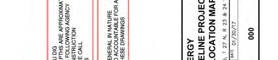
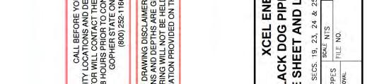
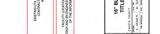
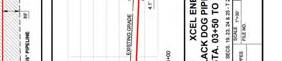
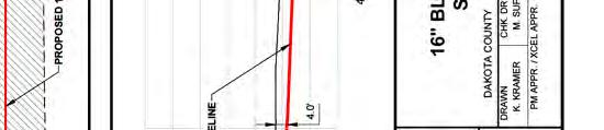
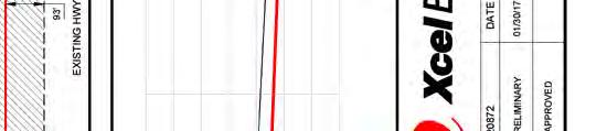
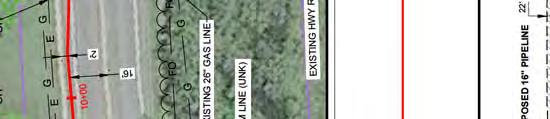
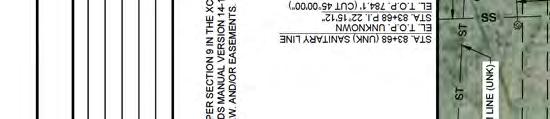
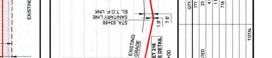
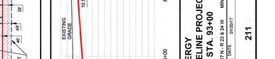
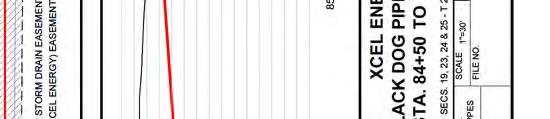
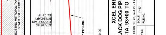
Plan and Profile for the Black Dog Natural Gas Pipeline Project Docket No. G002/GP
|
|
|
- Iris Pauline Richardson
- 5 years ago
- Views:
Transcription

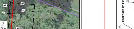
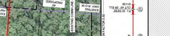
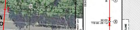
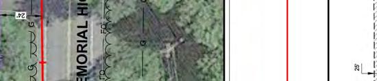
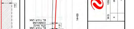
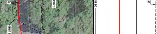
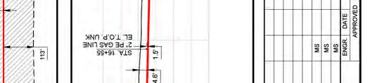
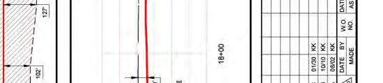
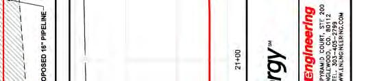
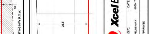
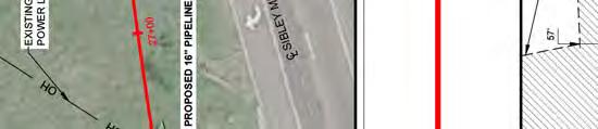
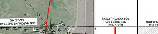
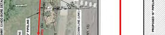
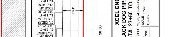
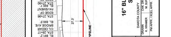
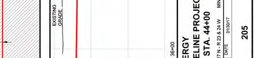
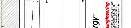
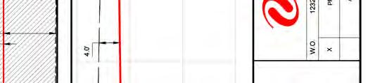
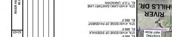
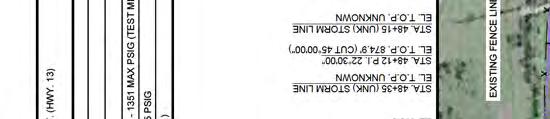
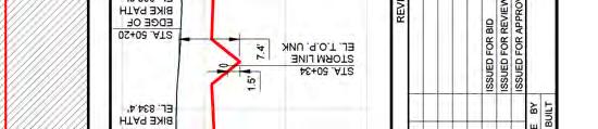
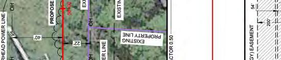
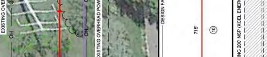
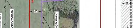
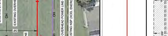
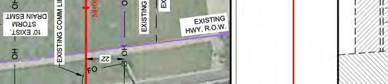
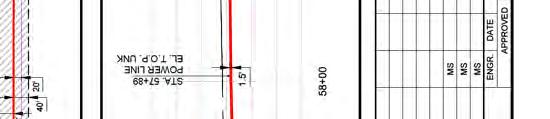
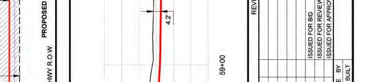
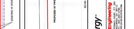
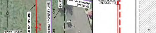
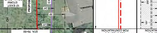
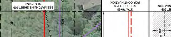
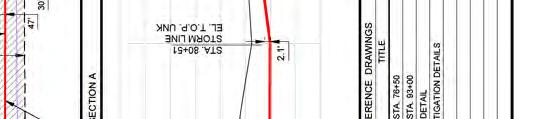
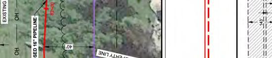
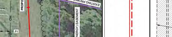
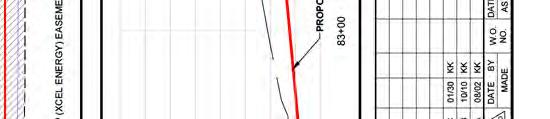
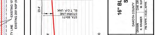
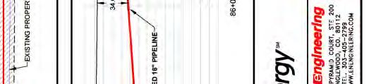
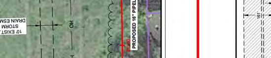
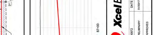
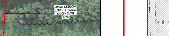
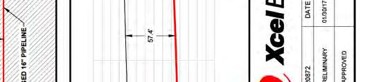
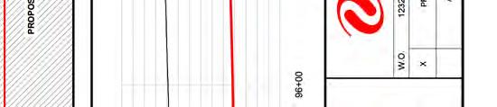
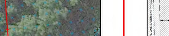
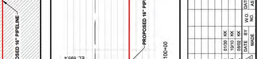
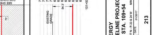
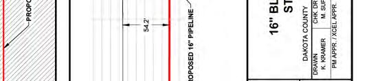
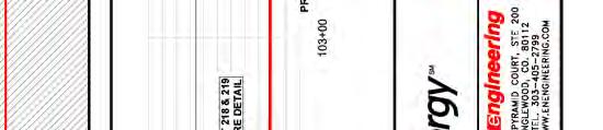
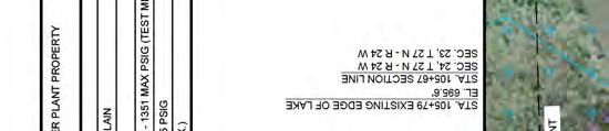
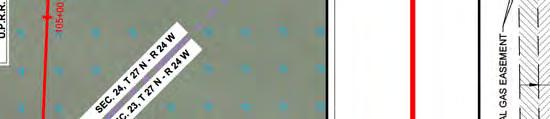
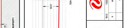
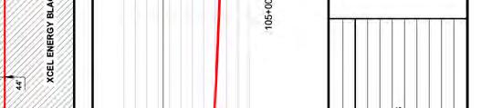
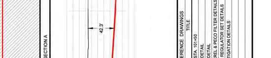
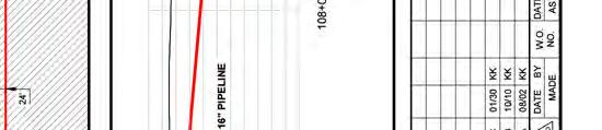
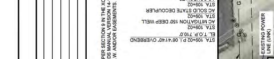
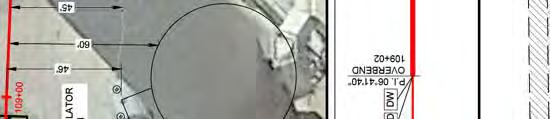
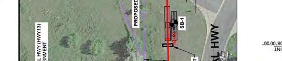
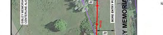
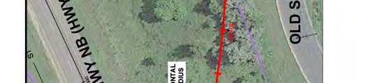
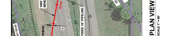
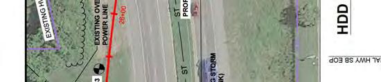
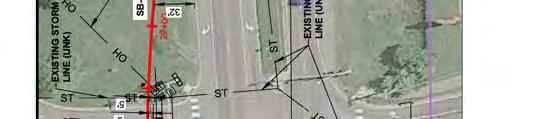
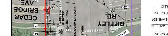
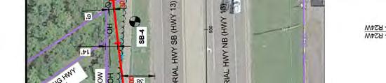
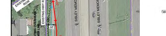
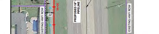
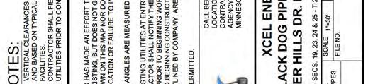
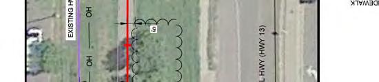
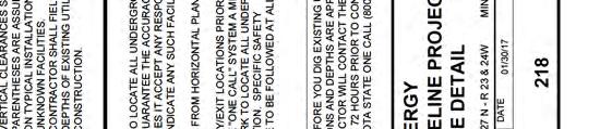
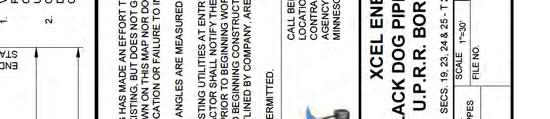
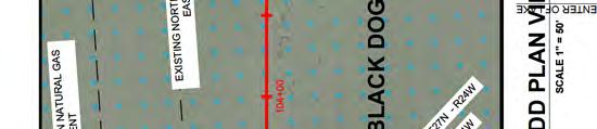
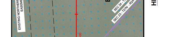
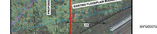
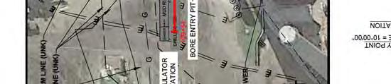
1 414 Nicollet Mall Minneapolis, MN March 13, 2017 Daniel P. Wolf Executive Secretary Minnesota Public Utilities Commission th Place East, Suite 350 St. Paul, MN Via Electronic Filing RE: Plan and Profile for the Black Dog Natural Gas Pipeline Project Docket No. G002/GP Dear Mr. Wolf: On March 7, 2017 the Public Utilities Commission granted Northern States Power Company (NSP), a Minnesota corporation, doing business as Xcel Energy, a Route Permit for the Black Dog Natural Gas Pipeline Project (Project) pursuant to Minnesota Rules Chapter As required by section 10.1 of the route permit, Xcel Energy respectfully submits the enclosed plan and profile drawings, aerial map set and specifications for right-of-way preparation, construction and restoration for the Project. Drawings 200 through 213 show the length of the pipeline from the NNG Cedar Station to the Black Dog Generating Plant. Drawings 214, 216, 218 and 219 specifically show each of the horizontal directionally drilled segments of the pipeline. This includes the crossing beneath Highway 13 and Cedar Bridge Avenue, beneath River Hills Dr. and the crossing beneath the Union Pacific RR and Black Dog Lake. The remaining portions of the pipeline will be open trench installation. An aerial map set is also enclosed which shows the pipeline alignment within the approved route and right-of-way. There is one privately owned parcel crossed by the pipeline just NW of the NNG Cedar Station. All other right-of-way is located on City, MnDOT or Union Pacific Railroad right-of-way or on land owned by the City of Burnsville or NSP. Prior to start of construction some tree clearing will be necessary along the pipeline to accommodate construction, but this will be minimized to the extent practicable. Xcel Energy is working with the cities of Eagan and Burnsville and with MnDOT on appropriate approvals for any tree removal and restoration requirements on city owned land or right-of-way and along MnDOT Hwy 13 right-of-way. During construction portions of the existing bike trail along Highway 13, between Cedar Bridge Avenue and the electric transmission line corridor, will need to be removed. The trail is owned by the City of Burnsville and Xcel Energy has received specifications from the City for replacement of the trail once construction is complete. The Project team has met with representatives of Metcalf Middle School and Sioux Trail Elementary School to discuss
2 construction impacts to the trail. At times when segments of the trail are impacted and unavailable for use by the public, temporary bypass options will be made available to allow students and other members of the public to travel past the site. Construction along Old Sibley Memorial Highway in Eagan will impact the existing roadway. The Project team met with Eagan staff to discuss impacts to the road and requirements for restoration. They also discussed development of a traffic plan to manage traffic along the road while it is impacted by construction. A traffic plan will be developed and provided along with the right-of-way permit application. A Stormwater Pollution Prevention Plan (SWPPP) has been developed and a copy was sent to the MN DNR and Lower Minnesota River Watershed District for review. Comments are being incorporated into the final SWPPP. Following completion of construction the bike trail along Highway 13 will be reconstructed to Burnsville standards and Old Sibley Memorial Highway will be reconstructed to Eagan standards. In all other locations soils will be graded to pre-construction contours and will be revegetated with appropriate seed mixes. Please contact me at ellen.l.heine@xcelenergy.com or if you have questions or would like further information regarding this matter. Sincerely, Ellen Heine Sr. Land Agent Xcel Energy
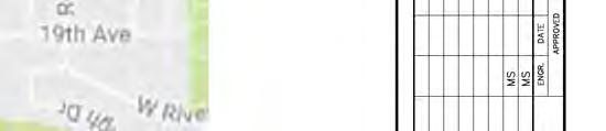
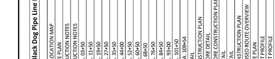
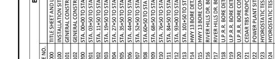
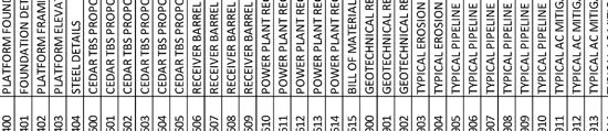
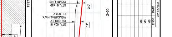
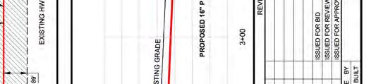
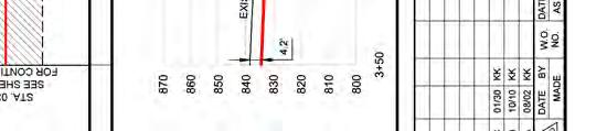
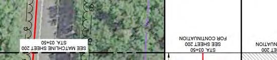
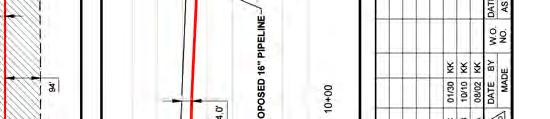
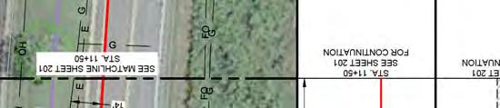
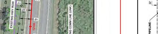
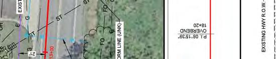
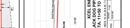
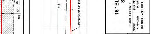
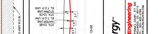
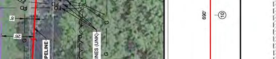
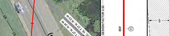
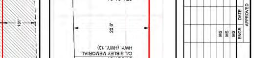
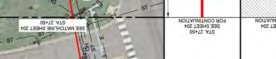
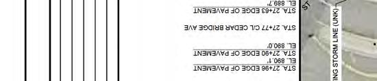
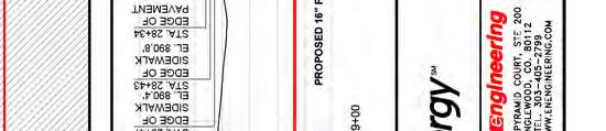
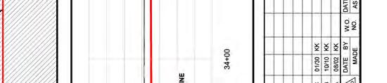
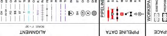
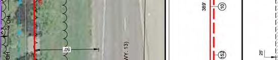
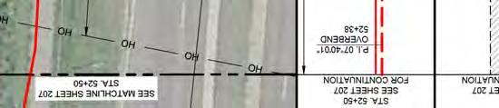
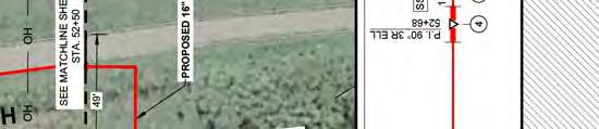
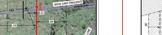
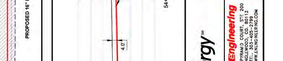
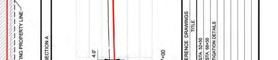
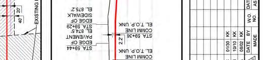
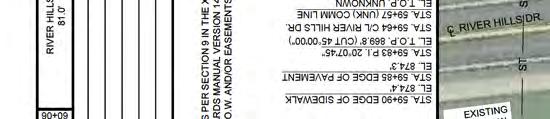
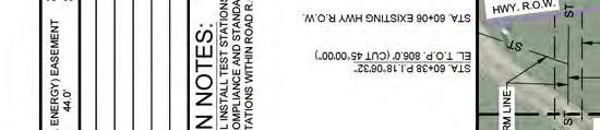
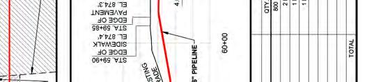
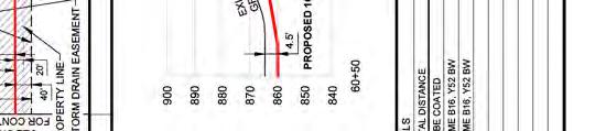
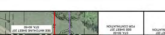
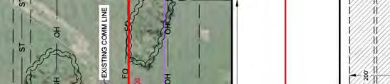
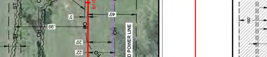
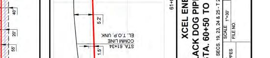
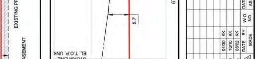
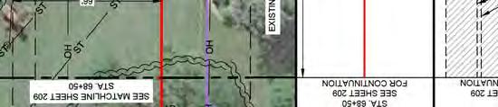
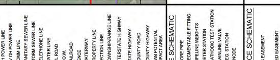
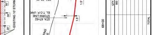
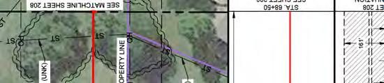
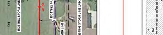
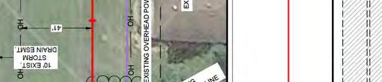
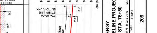
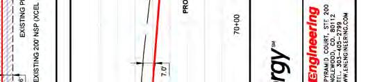
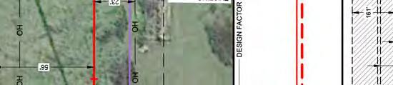
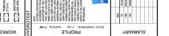
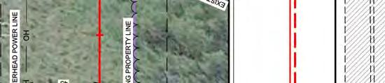
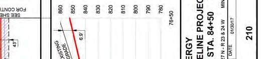
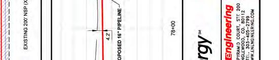
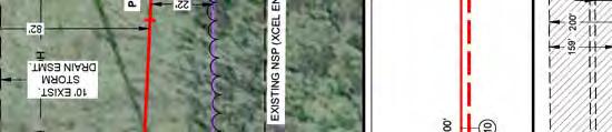
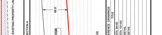
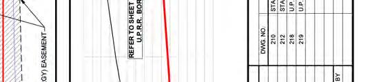
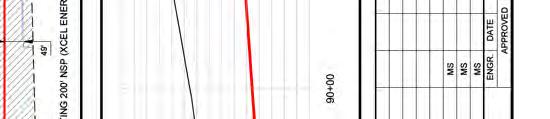
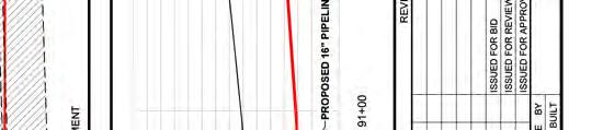
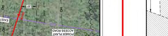
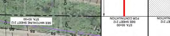
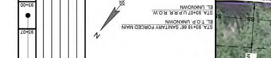
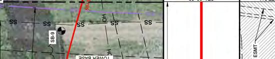
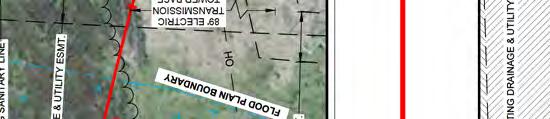
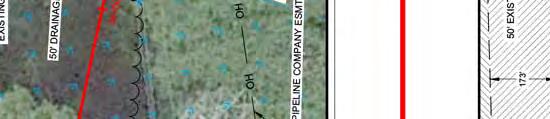
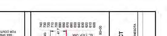
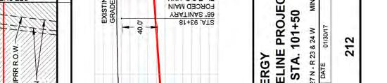
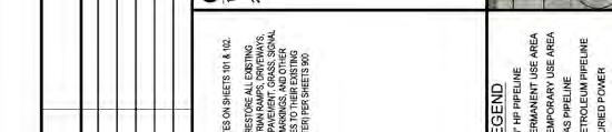
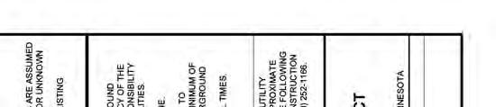
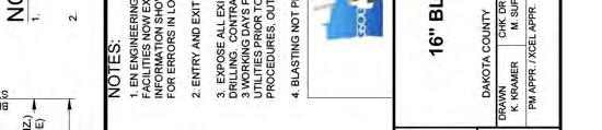
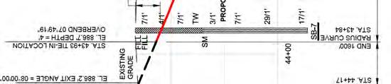
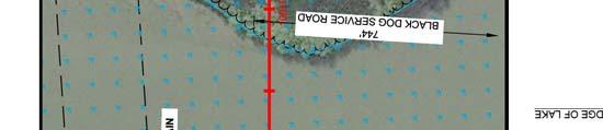
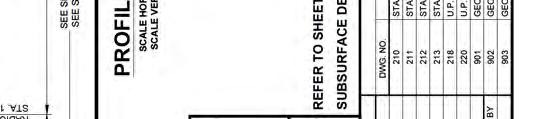
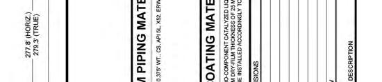
3 Plan and Profile Drawings


4


5


6


7


8


9


10


11


12


13

14


15


16


17


18


19


20


21


22


23
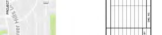
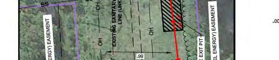
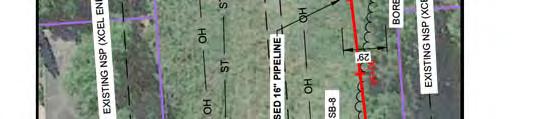
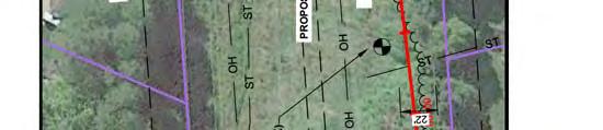
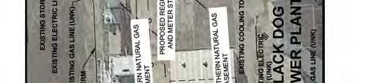
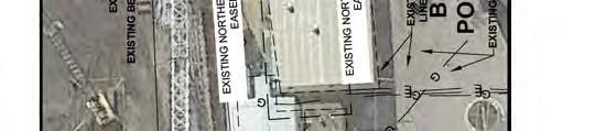
24 Aerial Alignment Maps
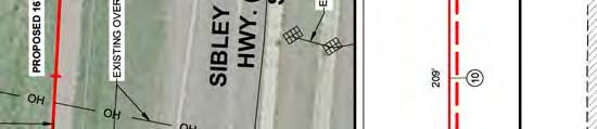
25 Sibley Ct Feet 1 inch = 300 feet For Environmental Review Purposes Only Data Sources: Xcel, MN DOT, Dakota County & MNDNR Imagery Sources: Twin Cities Metro Dakota County, 2013 Old Sibley Hwy Dakota County Figure 1 Xcel Energy Black Dog Gas Pipeline Project City of Eagan 77 Black Dog Generation Plant Cedar Station Pipeline Alignment Pipeline Route Pipeline ROW Parcel Boundary City Boundary Date: (3/13/2017) Source: Z:\Clients\U_X\Xcel\Black_Dog_Gas_Pipeline\Permitting\PUC_Route_Permit\Figures\Figure_1_Series_Black_Dog_Route_Aerial_Map.mxd
26 Foxpoint Cir Cedarbridge Ave Old Sibley Hwy Foxpoint Rd 30 Pioneer Dr Ridgewood Ct Southview Dr WRiver Hills Dr Feet 1 inch = 300 feet For Environmental Review Purposes Only Data Sources: Xcel, MN DOT, Dakota County & MNDNR Imagery Sources: Twin Cities Metro Dakota County, 2013 City of Burnsville N River Hills Dr Lake Ct Figure 1 Xcel Energy Black Dog Gas Pipeline Project Dakota County 112th St E Lewis Ct City of Eagan Metcalf Dr Medary Dr Black Dog Generation Plant Cedar Station Pipeline Alignment Pipeline Route Pipeline ROW Parcel Boundary City Boundary Date: (3/13/2017) Source: Z:\Clients\U_X\Xcel\Black_Dog_Gas_Pipeline\Permitting\PUC_Route_Permit\Figures\Figure_1_Series_Black_Dog_Route_Aerial_Map.mxd
27 Ha yes Ct Hayes Dr Chatham Ct S London Dr London Ct Radisson Dr Carver Ct 27th Ave 27th Pl Rid gewood Ct Radisson Ct Scout Cir Feet 1 inch = 300 feet For Environmental Review Purposes Only Explorer Ct Data Sources: Xcel, MN DOT, Dakota County & MNDNR Imagery Sources: Twin Cities Metro Dakota County, 2013 Dakota County 114th St E City of Burnsville Valley Ct Figure 1 Xcel Energy Black Dog Gas Pipeline Project W River Hills Dr Galtier Dr Galtier Pl 13 Black Dog Generation Plant Cedar Station Pipeline Alignment Pipeline Route Pipeline ROW Parcel Boundary City Boundary Date: (3/13/2017) Source: Z:\Clients\U_X\Xcel\Black_Dog_Gas_Pipeline\Permitting\PUC_Route_Permit\Figures\Figure_1_Series_Black_Dog_Route_Aerial_Map.mxd
28 Black Dog Rd Black Dog Lake City of Burnsville Black Dog Lake Feet 1 inch = 300 feet For Environmental Review Purposes Only Data Sources: Xcel, MN DOT, Dakota County & MNDNR Imagery Sources: Twin Cities Metro Dakota County, 2013 Figure 1 Xcel Energy Black Dog Gas Pipeline Project Dakota County River Ct Territorial Dr Radisson Dr Hayes Ct Black Dog Generation Plant Cedar Station Pipeline Alignment Pipeline Route Pipeline ROW Parcel Boundary City Boundary Date: (3/13/2017) Source: Z:\Clients\U_X\Xcel\Black_Dog_Gas_Pipeline\Permitting\PUC_Route_Permit\Figures\Figure_1_Series_Black_Dog_Route_Aerial_Map.mxd
STATE OF MINNESOTA OFFICE OF ADMINISTRATIVE HEARINGS FOR THE PUBLIC UTILITIES COMMISSION PUC DOCKET NO. E002/TL OAH DOCKET NO.
 Direct Testimony and Schedules Grant Stevenson STATE OF MINNESOTA OFFICE OF ADMINISTRATIVE HEARINGS FOR THE PUBLIC UTILITIES COMMISSION IN THE MATTER OF THE APPLICATION FOR A ROUTE PERMIT FOR THE PLEASANT
Re: Application for Approval of Route Permit Amendment, Spans 89-93, 95-97, and
 January 11, 2011 VIA ELECTRONIC FILING and U.S. MAIL Dr. Burl W. Haar Executive Secretary Minnesota Public Utilities Commission 350 Metro Square Building 121 Seventh Place East St. Paul, MN 55101 Dear
Transitways. Chapter 4
 4 Transitways Figure 4-1: Hiawatha LRT Train at the Lake Street/Midtown Station The 23 Transportation Policy Plan identifies a network of transitway corridors to be implemented by 23. Transitways recommended
We recommend you keep a copy of this ordinance with you while you are off-roading.
 ARTICLE IV. Operation of off-road vehicles, motorcycles and all-terrain vehicles We recommend you keep a copy of this ordinance with you while you are off-roading. DIVISION 1. - GENERALLY Sec. 70-85. -
Extending TRACKS. Preliminary design plan review underway. Public comment and approval process in May & June. Municipal Consent Process
 Extending TRACKS Issue 5 Spring 2014 Preliminary design plan review underway Public comment and approval process in May & June Residents and businesses along the Southwest LRT (METRO Green Line Extension)
Taylor s Falls Business Park
 Site Information Taylor s Falls Business Park County Road 37, Taylors Falls, MN Chisago County HRA-EDA 12/23/2014 Taylors Falls Business Park County Road 37 Taylors Falls, MN 55084 PROPERTY FEATURES: Zoned
ACTION TRANSMITTAL No
 Transportation Advisory Board of the Metropolitan Council of the Twin Cities DATE: January 4, 2016 TO: ACTION TRANSMITTAL No. 2016-19 TAC Funding and Programming Committee PREPARED BY: Joe Barbeau, Senior
Transportation Committee Revised Project Scope and Cost Estimate. November 23, 2015
 Transportation Committee Revised Project Scope and Cost Estimate November 23, 2015 1 Today s Topics Revised Project Scope Revised Cost Estimate Municipal Approval Action 2 3 Revised Project Scope Project
US 10 Corridor Performance
 Corridor Context The corridor runs northwest 18 miles from I-35W to the edge of Anoka County. The corridor connects the cities of Ramsey, Anoka,, Mounds View, and Blaine. Current Corridor Characteristics
I-35W Past, Present, and Future: METRO Orange Line
 I-35W Past, Present, and Future: METRO Orange Line 2018 State Public Transportation Partnerships Conference Charles Carlson Director, BRT Projects Metro Transit Charles.Carlson@metrotransit.org Metro Transit:
Committee Report. Transportation Committee. Business Item No
 Committee Report Business Item No. 2015-280 Transportation Committee For the Metropolitan Council meeting of December 9, 2015 Subject: METRO Blue Line Extension (Bottineau Light Rail Transit) Revised Scope
Recommended Transportation. Capital Improvement Program
 Recommended 2018-2022 Transportation Capital Improvement Program 1 Overview 2017 Review 2018-2022 Considerations 2018-2022 Recommended CIP 2 Limited Resources are Directed to the Highest Priority Number
2200 IDS Center 80 South 8th Street Minneapolis MN tel fax
 BRIGGS B R I G G S labo M O R G A N 2200 IDS Center 80 South 8th Street Minneapolis 55402-2157 tel 612.977.8400 fax 612.977.8650 EXHIBIT 40 3,2014 kchurch@briggs.com ELECTRONIC FILING Hon. Steve M. Mihalchick
STATE OF MINNESOTA OFFICE OF ADMINISTRATIVE HEARINGS FOR THE PUBLIC UTILITIES COMMISSION PUC DOCKET NO. E002/TL OAH DOCKET NO.
 STATE OF MINNESOTA Direct Testimony and Schedule OFFICE OF ADMINISTRATIVE HEARINGS FOR THE PUBLIC UTILITIES COMMISSION Amanda King IN THE MATTER OF THE ROUTE PERMIT APPLICATION FOR THE CAPX00 HAMPTON ROCHESTER
Business Advisory Committee. July 7, 2015
 Business Advisory Committee July 7, 2015 1 Today s Topics Outreach Update TI #1 and 2: Target Field Station Connection to I-94: Recommendation 85 th Station Configuration 93 rd Station Configuration DEIS
ACTION TRANSMITTAL
 Transportation Advisory Board of the Metropolitan Council of the Twin Cities DATE: February 12, 2014 TO: FROM: PREPARED BY: SUBJECT: REQUESTED ACTION: RECOMMENDED MOTION: ACTION TRANSMITTAL 2014-14 Transportation
Ramsey, Minnesota, Code of Ordinances >> PART II - CODE OF ORDINANCES >> Chapter 54 - TRAFFIC AND VEHICLES >> ARTICLE IV. - RECREATIONAL VEHICLES >>
 Ramsey, Minnesota, Code of Ordinances >> PART II - CODE OF ORDINANCES >> Chapter 54 - TRAFFIC AND VEHICLES >> ARTICLE IV. - RECREATIONAL VEHICLES >> ARTICLE IV. - RECREATIONAL VEHICLES [36] Sec. 54-96.
Current Corridor Characteristics. MN 62 Corridor Performance
 Corridor Context The corridor runs 12 miles between I-494 and MN 55 south of Minneapolis. The corridor serves as an important East-West connection for the Metro area. A portion of the corridor has been
I-394 Corridor Performance
 Population Trends Corridor Context The corridor runs from edge of Hennepin County to downtown Minneapolis and serves the cities of Delano, Independence, Medina, and Wayzata. City Population 2000 2010 2,088
Commercial Industrial Land Available
 Commercial Industrial Land Available PID: 200970010 List Price $744,292 Price Per Square Foot: $3.00 Sq. Ft. Property Details Street Address: Laredo St. & South St. Parcel ID: 200970010 City: Belle Plaine
Population Trends. US 12 Corridor Performance
 Corridor Context The corridor runs over 81 miles from Willmar to the Twins Cities metropolitan area. It connects the Twin Cities and the cities of Montrose, Howard Lake, Cokato, Dassel, Litchfield, Atwater,
This corridor section will carry commuter trains from Portland to Longview/Kelso, CHSR inter-city and inter-city express trains.
 Alignment is double tracked for 186 mph speeds. This corridor section will carry commuter trains from Portland to Longview/Kelso, CHSR inter-city and inter-city express trains. BNSF right-of-way will be
Public Information Workshop
 Public Information Workshop Charlotte County-Punta Gorda MPO - Meeting Rooms A and B March 29, 2018 Welcome to the Public Information Workshop for Harborview Road Project Development and Environment (PD&E)
2016 PSRC REGIONAL & KING COUNTYWIDE EASTSIDE FUNDING AWARDS. Eastside Transportation Partnership September 9, 2016
 2016 PSRC REGIONAL & KING COUNTYWIDE EASTSIDE FUNDING AWARDS Eastside Transportation Partnership September 9, 2016 1 2 PSRC 2016 Project Selection Process 2018-2020 Estimated FHWA Funds Available: (Summary)
April 6, The Honorable Kimberly D. Bose Secretary Federal Energy Regulatory Commission 888 First Street, NE Washington, DC 20426
 414 Nicollet Mall Minneapolis, MN 55401 The Honorable Kimberly D. Bose Secretary Federal Energy Regulatory Commission 888 First Street, NE Washington, DC 20426 RE: Public Service Company of Colorado Docket
BOARD OF SUPERVISORS BUSINESS MEETING ACTION ITEM. Design Endorsement for Sterling Boulevard Extension
 Date of Meeting: July 20, 2017 # 6 BOARD OF SUPERVISORS BUSINESS MEETING ACTION ITEM SUBJECT: ELECTION DISTRICT: CRITICAL ACTION DATE: STAFF CONTACTS: Design Endorsement for Sterling Boulevard Extension
I-820 (East) Project Description. Fort Worth District. Reconstruct Southern I-820/SH 121 Interchange
 Project Description. Fort Worth District. Reconstruct Southern I-820/SH 121 Interchange") I-820 (East) Project Description Fort Worth District Reconstruct Southern I-820/SH 121 Interchange I-820 from approximately 2,000 feet north of Pipeline Road/Glenview Drive to approximately 3,200 feet
I-820 (East) Project Description Fort Worth District Reconstruct Southern I-820/SH 121 Interchange I-820 from approximately 2,000 feet north of Pipeline Road/Glenview Drive to approximately 3,200 feet
Welcome. Highway 23 Gap New London to Paynesville. Open House. - Please Sign In -
 Highway Gap New London to Paynesville Welcome Highway Gap New London to Paynesville Open House - Please Sign In - There is no formal presentation, but representatives are available to answer your questions.
FREQUENTLY ASKED QUESTIONS
 THE PROJECT Last updated on 2/19/16 FREQUENTLY ASKED QUESTIONS What s happening on Highway 169? The Minnesota Department of Transportation (MnDOT) is planning to rebuild and repair the infrastructure on
Appendix A. Community Workshop Results PUBLIC REVIEW DRAFT
 Appendix A Community Workshop Results This Page Left Blank Intentionally Comprehensive Planning Community Workshop Summary July 30, 2012 The City of Becker invited the Community to participate in a Comprehensive
December 20, Burl W. Haar Executive Secretary Minnesota Public Utilities Commission 121 7th Place East, Suite 350 St. Paul, Minnesota
 December 20, 2012 Burl W. Haar Executive Secretary Minnesota Public Utilities Commission 121 7th Place East, Suite 350 St. Paul, Minnesota 55101-2147 RE: Comments of the Minnesota Department of Commerce,
Utility work, road construction substantially done on Fourth Street
 November 2010 Fourth Street in downtown is reopen to vehicle traffic between Minnesota and Broadway streets. Utility relocation and road construction are substantially complete there. Utility work, road
Energy Technical Memorandum
 Southeast Extension Project Lincoln Station to RidgeGate Parkway Prepared for: Federal Transit Administration Prepared by: Denver Regional Transportation District May 2014 Table of Contents Page No. Chapter
Highway 23 New London Access & Safety Assessment. Public Open House #2 October 3, :00 to 7:00 PM
 Public Open House #2 October 3, 2017 5:00 to 7:00 PM Highway 9 OVERVIEW OF ASSESSMENT Assessment Limits Highway 23 from County Road 40 to North Shore Dr Purpose: Identify opportunities to reduce serious
Memorandum. To: Sue Polka, City Engineer, City of Arden Hills. From: Sean Delmore, PE, PTOE. Date: June 21, 2017
 Memorandum engineering planning environmental construction 701 Xenia Avenue South Suite 300 Minneapolis, MN 55416 Tel: 763-541-4800 Fax: 763-541-1700 To: Sue Polka, City Engineer, City of Arden Hills From:
Open House. Highway212. Meetings. Corridor Access Management, Safety & Phasing Plan. 5:30 to 6:30 p.m. - Southwest Corridor Transportation Coalition
 Welcome Meetings 5:30 to 6:30 p.m. - Southwest Corridor Transportation Coalition 6:30 to 8:00 p.m. - Open House Why is Highway 212 Project Important? Important Arterial Route Local Support Highway 212
Public Information Packet FY Fargo-Moorhead Metropolitan Transportation Improvement Program (TIP)
") Public Information Packet FY - Fargo-Moorhead Metropolitan Transportation Improvement Program (TIP) Comment Form Annual Element TIP Projects - TIP Projects Year - Metropolitan Transportation Improvement
Public Information Packet FY - Fargo-Moorhead Metropolitan Transportation Improvement Program (TIP) Comment Form Annual Element TIP Projects - TIP Projects Year - Metropolitan Transportation Improvement
STAFF REPORT. To: Planning Commission Meeting date: April 12, 2017 Item: UN Prepared by: Robert Eastman
 # 5 ) UN-15-17 LA SIERRA AUTO SALES SPECIAL USE PERMIT VEHICLE SALES PUBLIC HEARING STAFF REPORT To: Planning Commission Meeting date: April 12, 2017 Item: UN-15-17 Prepared by: Robert Eastman GENERAL
Agenda. Utility Undergrounding Strategies & Laguna Canyon Road Master Plan
 Utility Undergrounding Strategies & Laguna Canyon Road Master Plan January 17, 2017 City Council Meeting 2 Agenda Progress since March 2016 Status of undergrounding and road widening between El Toro Rd.
Background Information for MPRB Community Advisory Committee for 2010 Southwest Light Rail Transit Project DEIS Comment Letter Section 2
 Background Information for MPRB Community Advisory Committee for 2010 Southwest Light Rail Transit Project DEIS Comment Letter Section 2 1 2. SW LRT Corridor Overview Source: http://www.southwesttransitway.org/home.html
West Broadway Reconstruction/LRT Design. March 19, 2015
 West Broadway Reconstruction/LRT Design March 19, 2015 1 Meeting Agenda 6:05 6:30 PM Brief presentation What we heard Project overview 6:30 8:00 PM Visit Six Topic Areas Road and LRT design elements Pedestrian
FREQUENTLY ASKED QUESTIONS
 THE PROJECT Last updated on 9/8/16 FREQUENTLY ASKED QUESTIONS What s happening on Highway 169? The Minnesota Department of Transportation (MnDOT) is planning to rebuild and repair the infrastructure on
Transportation. Background. Transportation Planning Goals. Level of Service Analysis 5-1
 Transportation portion of the city s stormwater utility, and state road and fuel taxes. Background The transportation needs of the City of Lacey and its planning areas are met by a growing multimodal network
FEASIBILITY REPORT. 65 th STREET TRUNK WATER MAIN IMPROVEMENTS INVER GROVE HEIGHTS MINNESOTA DAKOTA COUNTY. October 2, 2017
 FEASIBILITY REPORT 65 th STREET TRUNK WATER MAIN IMPROVEMENTS INVER GROVE HEIGHTS MINNESOTA DAKOTA COUNTY October 2, 2017 Prepared for: City of Inver Grove Heights 8150 Barbara Avenue Inver Grove Heights,
2 EXISTING ROUTE STRUCTURE AND SERVICE LEVELS
 2 EXISTING ROUTE STRUCTURE AND SERVICE LEVELS In the Study Area, as in most of the Metro Transit network, there are two distinct route structures. The base service structure operates all day and the peak
Business Advisory Committee. November 3, 2015
 Business Advisory Committee November 3, 2015 1 Today s Topics DEIS Cost Estimate 2 Assumptions Revised Cost Estimate Revised Project Scope Cost Estimate Overview Position Statement Discussion Municipal
Tracking the Blue Line Extension
 BROOKLYN PARK CRYSTAL ROBBINSDALE GOLDEN VALLEY MINNEAPOLIS Tracking the Blue Line Extension Issue 4 December 2015 Metropolitan Council approves refined 11-station scope and $1.496 billion cost estimate
CEDAR AVENUE TRANSITWAY Implementation Plan Update
 CEDAR AVENUE TRANSITWAY Implementation Plan Update EECUTIVE SUMMARY DECEMBER 2015 Executive Summary In 2013, the Twin Cities metropolitan area s first bus rapid transit (BRT) line, the METRO Red Line,
Trunk Highway 13 Corridor Study Update Existing and No-Build Conditions Technical Memo #2B: Traffic Forecasts and Operations Analysis SEH No.
 TECHNICAL MEMORANDUM TO: FROM: Molly McCartney MnDOT Project Manager Haifeng Xiao, PE Tom Sohrweide, PE, PTOE DATE: November 27, 2012 RE: Trunk Highway 13 Corridor Study Update Existing and No-Build Conditions
Start of route 0.0
 #4 CHEW South 2017 #4 CHEW South 2017 1 00 00 Start of route 00 2 00 00 L onto Celebration Park Rd 01 3 01 01 R onto S 330th St 04 4 05 04 R onto 20th Ave S at small traffic circle 04 5 09 04 L onto S
EXCEPTION TO STANDARDS REPORT
 EXCEPTION TO STANDARDS REPORT PROJECT DESCRIPTION AND NEED The project is located in Section 6, Township 23 North, Range 9 East and Section 31 Township 24 North, Range 9 East, in the Town of Stockton,
PUBLIC INFRASTRUCTURE PROJECTS
 PUBLIC INFRASTRUCTURE PROJECTS FM 664 / OVILLA ROAD WIDENING & IMPROVEMENTS FM 664 / OVILLA ROAD CONNECTS US 287 WITH I-45 (SOURCE: TEXAS DEPARTMENT OF TRANSPORTATION. 2016 FM 664 / OVILLA ROAD WIDENING
ST. CROIX RIVER CROSSING PROJECT 2004 SUPPLEMENTAL ENVIRONMENTAL IMPACT STATEMENT TECHNICAL MEMORANDUM SUPPLEMENT FOR THE PREFERRED ALTERNATIVE:
 ST. CROIX RIVER CROSSING PROJECT 2004 SUPPLEMENTAL ENVIRONMENTAL IMPACT STATEMENT TECHNICAL MEMORANDUM SUPPLEMENT FOR THE PREFERRED ALTERNATIVE: TRAVEL DEMAND FORECASTS May 12, 2005 Prepared for Minnesota
Brigham City 1200 West Box Elder Creek Bridge - Widening Project Type Reconstruction
 Brigham City 1200 West Box Elder Creek Bridge - Widening Project Type Reconstruction 550 North to 650 North $ 1,750,000 $ 1,582,113 To widen an existing bridge on 1200 West over Box Elder Creek that will
Lake View Ave Bennett St. Grant Ave. Page Ave ft 1326 ft 685 ft. Park Ave. Belgrade Ave. ! Spinner's Bar. Sherman St. Cornelia St.
 CLENT elgrade venue Corridor Study ccess nventory Mankato/ rea Planning Organization ugust, 06 ccess Length of Corridor (ft),96 # of Primary ccess 6 Primary ccess Per Mile 6 # of Secondary ccess 7 Secondary
STATE OF MINNESOTA OFFICE OF ADMINISTRATIVE HEARINGS FOR THE PUBLIC UTILITIES COMMISSION DIRECT TESTIMONY OF GRANT STEVENSON. On Behalf of APPLICANT
 EXHIBIT Direct Testimony and Schedules Grant Stevenson STATE OF MINNESOTA OFFICE OF ADMINISTRATIVE HEARINGS FOR THE PUBLIC UTILITIES COMMISSION IN THE MATTER OF THE APPLICATION FOR A ROUTE PERMIT FOR THE
Community Advisory Committee. October 5, 2015
 Community Advisory Committee October 5, 2015 1 Today s Topics Hennepin County Community Works Update Project Ridership Estimates Technical Issue #4:Golden Valley Rd and Plymouth Ave Stations Technical
April 18, Mr. David Schmit, County Manager Arapahoe County 5334 S. Prince Street Littleton, CO Conoco Phillips Section 6 Swan Well
 April 18, 2018 Mr. David Schmit, County Manager Arapahoe County 5334 S. Prince Street Littleton, CO 80120 Re: Conoco Phillips Section 6 Swan Well Dear David, It is our understanding that Conoco Phillips
Sales and Use Transportation Tax Implementation Plan
 Sales and Use Transportation Tax Implementation Plan Transportation is more than just a way of getting from here to there. Reliable, safe transportation is necessary for commerce, economic development,
STATE OF NEW HAMPSHIRE Inter-Department Communication
 STATE OF NEW HAMPSHIRE Inter-Department Communication DATE: February 11, 2010 AT (OFFICE): NHPUC FROM: Torn Frantz Director, Electric Division SUBJECT: DE 09-277: Petition by Public Service Company of
Prior Lake - Savage Area Schools Prior Lake, MN
 Prior Lake - Savage Area Schools Prior Lake, MN Elementary Boundary Change Options A-1 and B-1: March 12 th, 2019 Report created by TeamWorks International, Inc 7037 20th Avenue S. Centerville, MN 55038
ROCKY MOUNTAIN POWER A DIVISION OF PACIFICORP
 ROCKY MOUNTAIN POWER A DIVISION OF PACIFICORP January 29, 2014 201 South Main, Suite 2300 Salt Lake City, Utah 84111 VIA ELECTROl.fiC FILI1VG AND OVERNIGHT DELIVERY Wyoming Public Service Commission 2515
F:\PROJ\ \dwg\Alt-bridge-alignments.dwg, 17-2, 11/12/ :22:17 PM, saamhu, Acrobat PDFWriter
 F:\PROJ\55211014\dwg\Alt-bridge-alignments.dwg, 17-2, 11/12/2002 03:22:17 PM, saamhu, Acrobat PDFWriter MERRIFIELD RIVER CROSSING METHOD OF CHANGE FROM ID# ISSUES MEASUREMENT UNITS VALUE BASE CONDITIONS
DRIVEWAY STANDARDS EXHIBIT A. The following definition shall replace the definition of driveway in Section 62:
 1365 S. Camino del Rio Durango, CO 81303 970-382-6363 DRIVEWAY STANDARDS Resolution 2014-40 EXHIBIT A The following definition shall replace the definition of driveway in Section 62: Driveway means a roadway,
Included in this Stakeholder Information Package:
 Who can you contact for more information? Yellowhead Area Transmission Reinforcement: TERA Environmental Consultants Dave Sare Phone: 403-538-5734 Email: dsare@teraenv.com Drayton Valley Area AltaLink
STH 60 Northern Reliever Route Feasibility Study Report
 #233087 v3 STH 60 Northern Reliever Route Feasibility Study Report Washington County Public Works Committee Meeting September 28, 2016 1 STH 60 Northern Reliever Route Feasibility Study Hartford Area Development
Nonprofit Insurance Trust (NIT) Preferred Shop Network
 Preferred Shop Network") Nonprofit Insurance Trust (NIT) Preferred Shop Network NPIA, Inc. on behalf of the Nonprofit Insurance Trust and its members, has implemented a Preferred Shop Network for vehicle repairs. These shops have
Nonprofit Insurance Trust (NIT) Preferred Shop Network NPIA, Inc. on behalf of the Nonprofit Insurance Trust and its members, has implemented a Preferred Shop Network for vehicle repairs. These shops have
HSR Vancouver WA to Camas Commuter Des, by R.N.
 This plan will show the new route for the Portland-Vancouver Junction Railroad. Remove the existing Portland-Vancouver Junction Railroad leg from the Northeast Hazel Dell Avenue curve to the Burlington
April 2014: Capital Improvements Update. through $ 102,233,755 Available Funding through 2019 $ 149,764,558. Staff s Recommendation
 Capital Improvements Update April 2014: Pl dp j t Planned Projects through 2019 - $ 102,233,755 Available Funding through 2019 $ 149,764,558 pp p,, Un-appropriated - $ 47,530,803 Staff s Recommendation
RTID Travel Demand Modeling: Assumptions and Method of Analysis
 RTID Travel Demand Modeling: Assumptions and Method of Analysis Overall Model and Scenario Assumptions The Puget Sound Regional Council s (PSRC) regional travel demand model was used to forecast travel
LACEY CITY COUNCIL MEETING July 09, 2015
 LACEY CITY COUNCIL MEETING July 09, 2015 SUBJECT: 2016-2021 Six-Year Transportation Improvement Plan and Mitigation List RECOMMENDATION: Adopt Resolution approving the proposed 2016-2021 Six- Year Transportation
Additional $200 Speeding Fine Signs
 CITY OF CHARLOTTESVILLE, VIRGINIA CITY COUNCIL AGENDA Agenda Date: June 18, 2007 Action Required: Presenter: Staff Contacts: Title: Adopt Ordinance Jeanie Alexander, P.E. Jeanie Alexander Additional $200
Public Works. Capital Projects FY
 Public Works Capital Projects FY 2015-17 Projects Completed FY 2014 All Done Projects! Residential and Collector Street Paving Lower Westside Arterial Street Rehab: Front, River St South, Soquel Hwy 1
TRAFFIC IMPACT STUDY. USD #497 Warehouse and Bus Site
 TRAFFIC IMPACT STUDY for USD #497 Warehouse and Bus Site Prepared by: Jason Hoskinson, PE, PTOE BG Project No. 16-12L July 8, 216 145 Wakarusa Drive Lawrence, Kansas 6649 T: 785.749.4474 F: 785.749.734
Decision D ATCO Electric Ltd. Decommissioning of Transmission Line 6L82
 Decision 21447-D01-2016 August 23, 2016 Decision 21447-D01-2016 Proceeding 21447 Application 21447-A001 August 23, 2016 Published by the: Fifth Avenue Place, Fourth Floor, 425 First Street S.W. Calgary,
East Kings Highway and Roberts Avenue Speed Hump Analysis
 East Kings Highway and Roberts Avenue Speed Hump Analysis BOROUGH OF HADDONFIELD, CAMDEN COUNTY, NEW JERSEY 5/18/2018 Prepared By: Remington & Vernick Engineers 232 EAST KINGS HIGHWAY, HADDONFIELD, NEW
Introduction. Assumptions. Jeff Holstein, P.E., City of Brooklyn Park Steve Wilson, Principal Tim Babich, Associate Krista Anderson, Engineer
 SRF No. 10482 To: From: Jeff Holstein, P.E., City of Brooklyn Park Steve Wilson, Principal Tim Babich, Associate Krista Anderson, Engineer Date: May 16, 2018 Subject: City of Brooklyn Park Year 2040 Forecasts
/ Planning and Zoning Staff Report Lonestar Land, LLC. - Rezone, RZ
 / Planning and Zoning Staff Report Lonestar Land, LLC. - Rezone, RZ2018-0019 Hearing Date: October 18, 2018 Development Services Department Applicant: Lonestar Land, LLC. Representative: Lance Warnick
Speed measurements were taken at the following three locations on October 13 and 14, 2016 (See Location Map in Exhibit 1):
:") 2709 McGraw Drive Bloomington, Illinois 61704 p 309.663.8435 f 309.663.1571 www.f-w.com www.greennavigation.com November 4, 2016 Mr. Kevin Kothe, PE City Engineer City of Bloomington Public Works Department
2709 McGraw Drive Bloomington, Illinois 61704 p 309.663.8435 f 309.663.1571 www.f-w.com www.greennavigation.com November 4, 2016 Mr. Kevin Kothe, PE City Engineer City of Bloomington Public Works Department
CROW WING COUNTY HIGHWAY DEPARTMENT APPLICATION FOR PERMIT TO CONSTRUCT DRIVEWAY ACCESS TO ROADS UNDER COUNTY JURISDICTION CONSTRUCTION INFORMATION
 CROW WING COUNTY HIGHWAY DEPARTMENT APPLICATION FOR PERMIT TO CONSTRUCT DRIVEWAY ACCESS TO ROADS UNDER COUNTY JURISDICTION Crow Wing County Highway Department 16589 CR 142 Brainerd, MN 56401 Crow Wing
BROWARD BOULEVARD CORRIDOR TRANSIT STUDY
 BROWARD BOULEVARD CORRIDOR TRANSIT STUDY FM # 42802411201 EXECUTIVE SUMMARY July 2012 GOBROWARD Broward Boulevard Corridor Transit Study FM # 42802411201 Executive Summary Prepared For: Ms. Khalilah Ffrench,
MUNICIPALITY OF ANCHORAGE Capital Improvement Program PRIORITY LIST BY DEPARTMENT (000's) PROJECT MANAGEMENT & ENGINEERING
 PROJECT MANAGEMENT & ENGINEERING") YEAR PROJECT TITLE CATEGORY: Roadway Improvements MUNICIPALITY OF ANCHORAGE Capital Improvement Program PRIORITY LIST BY DEPARTMENT (000's) PROJECT MANAGEMENT & ENGINEERING DEPT PRIORITY GO BONDS MATCHING
YEAR PROJECT TITLE CATEGORY: Roadway Improvements MUNICIPALITY OF ANCHORAGE Capital Improvement Program PRIORITY LIST BY DEPARTMENT (000's) PROJECT MANAGEMENT & ENGINEERING DEPT PRIORITY GO BONDS MATCHING
FISCHER, FRANKLIN & FORD Attorneys and Counsellors GUARDIAN BUILDING, SUITE GRISWOLD STREET DETROIT, MICHIGAN
 ARTHUR J. LeVASSEUR MATTHEW M. PECK TROY C. OTTO SIDNEY M. BERMAN* LAUREN J. McGILL* *Of Counsel FISCHER, FRANKLIN & FORD Attorneys and Counsellors GUARDIAN BUILDING, SUITE 3500 500 GRISWOLD STREET DETROIT,
Assisted Living / Memory Care - South Forsyth
 ! Assisted Living / Memory Care - South Forsyth LOCATION: 6388 Post Road, Cumming, GA 30040 - Forsyth County Parcel ID - 037-012 2 nd District, 1 st Section, Land Lot 317 SIZE: 5.4723 acres +/- ZONING:
Project Description: Georgia Department of Transportation Public Information Open House Handout PI#(s): , County: Muscogee
: , County: Muscogee") Why We Are Here: GDOT s Transportation Improvement Act (TIA) Office, the City of Columbus, and the project delivery team are here this evening to display and answer questions concerning the proposed roadway
Why We Are Here: GDOT s Transportation Improvement Act (TIA) Office, the City of Columbus, and the project delivery team are here this evening to display and answer questions concerning the proposed roadway
This page is intentionally left blank.
 This page is intentionally left blank. Bipole III Southern Ground Electrode Line Route Selection Introduction Manitoba Hydro has recently selected a route for the southern ground electrode line (Map 1).
ITEM 13 - NOTICE May 20, 2009
 ITEM 13 - NOTICE May 20, 2009 Notice of Proposed Amendment to the 2009 CLRP and FY 2010-2015 TIP to include the Closure of the I-395 Southbound Exit Ramp to 3rd Street NW, the Reconfiguration of the Southbound
DRAFT Design Study Report February 2015 Eagle River Traffic Mitigation Phase 1 MOA Project No Appendix D Utilities
 Appendix D Utilities This page intentionally left blank. Utilities There are numerous utilities present within the project area, including natural gas, sewer, water, electric, communications, and street
4 Circulation & Transportation
 4.1 Mobility Network The mobility network at the new St. Paul s hospital and health campus is comprised of an interconnected system of sidewalks, cycle paths, transit routes and roadways. Figure 4-1: Indicative
MUNICIPAL CLASS EA PROCESS 1
 PHASE 1 PROBLEM OR OPPORTUNITY PHASE 2 PHASE 3 PHASE 4 PHASE 5 ALTERNATIVE SOLUTIONS ALTERNATIVE DESIGN CONCEPTS FOR PREFERRED SOLUTION ENVIRONMENTAL STUDY REPORT IMPLEMENTATION 1. Identify problem or
WOODVILLE HIGHWAY (SR 363) PD&E STUDY From Capital Circle Southeast To Paul Russell Road FPID NUMBER: Public Hearing
 PD&E STUDY From Capital Circle Southeast To Paul Russell Road FPID NUMBER: Public Hearing") WOODVILLE HIGHWAY (SR 363) PD&E STUDY From Capital Circle Southeast To Paul Russell Road FPID NUMBER: 424009-3 Public Hearing May 9, 2013 This Public Hearing is being held in accordance with the Federal-aid
WOODVILLE HIGHWAY (SR 363) PD&E STUDY From Capital Circle Southeast To Paul Russell Road FPID NUMBER: 424009-3 Public Hearing May 9, 2013 This Public Hearing is being held in accordance with the Federal-aid
CHAPTER 14 TRAFFIC CODE THE MINNESOTA HIGHWAY TRAFFIC REGULATION ACT.
 CHAPTER 14 TRAFFIC CODE 14.01 THE MINNESOTA HIGHWAY TRAFFIC REGULATION ACT. 1. Adoption. The City hereby adopts the Minnesota Highway Traffic Regulation Act as set forth in Minnesota Statutes, Chapter
2017 Industrial Rail and Transportation Study. Becker, Minnesota
 2017 Industrial Rail and Transportation Study Becker, Minnesota BECKR 140932 August 2, 2017 2017 Industrial Rail and Transportation Study Becker, Minnesota SEH No. BECKR 140932 August 2, 2017 I hereby
Mr. Leif Dormsjo Director, District Department of Transportation 55 M Street, SE Washington, DC July 10, Dear Director Dormsjo,
 Adams Morgan BID Capitol Hill BID Capitol Riverfront BID Coalition for Smarter Growth Destination DC Downtown BID Events DC Federal City Council Georgetown BID Golden Triangle BID Greater Greater Washington
TSPLOST 2018 Project Request $ 1,531,000 Estimated Annual Operating Impact $ 0
 TSPLOST 2018 Project Statements from Submitted Projects Project # 01, 01 Airport Capital Improvements Program (CIP) Matching Funds, will include the construction of numerous FAA and GDOT funded projects
Purpose and Need Report
 Purpose and Need Report State Highway (SH) 29 From Southwestern Boulevard to SH 95 Williamson County, Texas (CSJ: 0337-02-045) Prepared by Blanton & Associates, Inc. Date: November, 2015 The environmental
Alberta Electric System Operator Needs Identification Document Application. Mowat 2033S Substation
 Decision 21781-D01-2016 Alberta Electric System Operator Needs Identification Document Application Facility Applications September 7, 2016 Alberta Utilities Commission Decision 21781-D01-2016: Alberta
SOUTHERN GATEWAY. Transportation and Trinity River Project Committee 11 May 2015
 SOUTHERN GATEWAY Transportation and Trinity River Project Committee 11 May 2015 Southern Gateway Project History Began in 2001 as a Major Investment Study [ MIS ], Schematic, and Environmental Assessment
Comprehensive Lift Station Evaluation Buffalo, Minnesota
 City of Buffalo Comprehensive Lift Station Evaluation Buffalo, Minnesota W3.088 Submitted by: Bolton & Menk, Inc. 040 Hwy East Willmar, MN 560 P: 30-3-3956 F: 30-3-970 Certification Comprehensive Lift
Key Project Elements Status Report
 Los Angeles County Metropolitan Transportation Authority Key Project Elements Status Report presented to the Corridor Advisory Committee August 18, 2016 Background Motion 22.1 elements are grouped into