I-494/I-35 Interchange Vision Layout Development - BRT Station Concepts S.P B SEH No
|
|
|
- Dortha Sherman
- 5 years ago
- Views:
Transcription
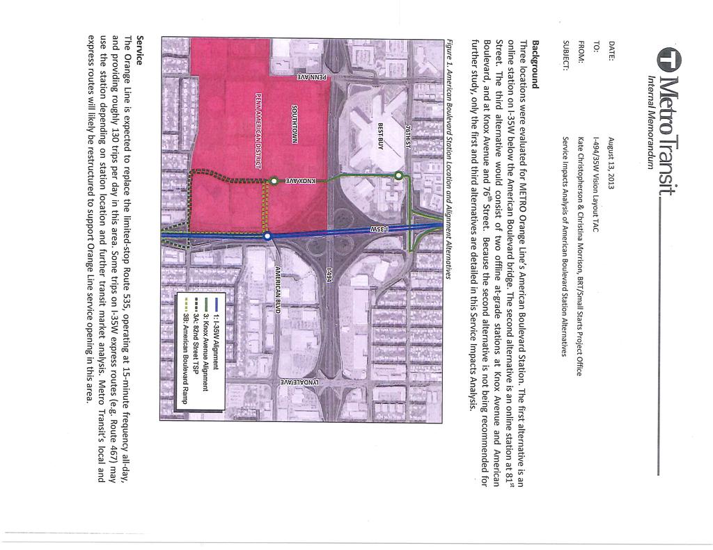
1 TECHNICAL MEMORANDUM TO: FROM: Transit Advisory Group Jeff Rhoda DATE: RE: I-494/I-35 Interchange Vision Layout Development - BRT Station Concepts S.P B SEH No I-494/I-35W Interchange Vision Layout Development Bus Rapid Transit (BRT) Station Concepts Development and Evaluation Objective The I-494/I-35W Interchange Vision Layout Development project is the continuation of the I-494/I-35W Interchange Preliminary Design Project completed in 2010, seeking to further refine concepts for the interchange and an I-35W BRT station to serve the American Boulevard location, as illustrated on Metro Transit s Orange Line BRT station map to the right. The ultimate goal for this study is to determine a Vision Layout or the most desired concept for the I-494/I-35W interchange and BRT station development. The objective of this technical memorandum is to summarize the development and evaluation of the BRT station concepts and to recommend the most desired BRT station concept for inclusion with the Vision Layout for the interchange. Background Stretching from Burnsville to downtown Minneapolis, the 16 mile corridor of I-35W has been the most heavily traveled express bus corridor since the 1970s, with approximately 14,000 daily rides. Metro Transit is currently developing the Orange Line BRT with 10 upgraded stations along I-35W, including a new station in the vicinity of the American Boulevard overpass in Bloomington. The development of concepts for an American Boulevard BRT station began with the I-494/I-35W Interchange Preliminary Design Project. The final report for that project can be found at the following link: This project, in addition to developing new interchange concepts, developed an initial list of ten BRT station concepts, with accompanying park-and-ride site, with the goal to narrow the list to three desirable concepts for further study. Short Elliott Hendrickson Inc., 3535 Vadnais Center Drive, St. Paul, MN SEH is an equal opportunity employer fax


2 Page 2 The process for narrowing the list of concepts included the creation of an evaluation matrix through input from the project s Technical Advisory Committee (TAC). The matrix included evaluation criteria based on three main categories which included: Users, Site and Operations. These three categories were further broken down into specific evaluation criteria items in order to rate each BRT concept. The ratings were based on a simple relative comparison of Positive, Neutral and Negative impacts to the defined evaluation criteria. A copy of the 2010 BRT evaluation matrix is included on page 3. The individual TAC members completed their ratings of the concepts and then the TAC group compared these ratings, discussed individual variations in ratings and determined agreed final ratings of the evaluation matrix. The three concepts identified through the 2010 evaluation matrix ratings for further review included: Online I-35W at American Boulevard Includes a single platform station in the I-35W median with weaving bus movement (accommodates bus right side enter/exit), vertical circulation to American Blvd. and widening of the American Blvd. bridge to accommodate bus pullout areas on each side of the bridge. Image is an example rendering of the I-35W and 46 th Street BRT Station, which is now in operation. Online I-35W south of American Boulevard Includes a dual side platform station (eliminates weaving movement) in the I-35W median located between American Blvd. and 82 nd St. and vertical circulation to an overhead pedestrian skyway (from a parking structure located off the right-of-way). Image is an example rendering from another BRT project. Off line I-35W T Bus Ramp between 82 nd St. and American Boulevard Includes a bus ramp located in the I-35W median between American Blvd. and 82 nd St. connecting to an overpass bridge of southbound I-35W which leads to a transfer station and parking structure west of 35W, located off the interstate rightof-way. Image is an example photo from another BRT project location. The completion of the 2010 study recommended these three BRT station concepts to move forward for future study and determination of the most desired concept for inclusion with the future interchange layout. In addition, all three station concepts were determined to be compatible with potential interchange layouts under consideration.
3 Page BRT Station Evaluation Matrix
4 Page 4 Concepts The development of concepts under the I-494/I-35W Interchange Vision Layout study began with the three previously established concepts from the 2010 study. Through the efforts of both the TAC and the Transit Advisory Group (TAG a small working group comprised of members from the TAC) these three concepts were reviewed for compatibility with current objectives and interchange layouts and then expanded into a new list of concepts for consideration. A key item for the online I-35W station concepts was the single center platform vs. dual side platforms layout. The 46 th Street BRT station, operational in 2010, was built with a single center platform where the buses perform a weave movement to facilitate the right-side door access to the platform. Study of the Lake Street BRT station in 2012 determined that due to safety and operational concerns resulting from higher bus volume projections for that station, a dual side platform layout would be utilized. As a result, it was determined that an online BRT station at American Boulevard would also utilize the dual side platform layout. Through the development of layouts for these expanded concepts, key features and impacts were identified which allowed the concepts to be further refined and a final list of seven station concepts was established. Final Concepts List Original Concepts List Online I-35W at American Blvd. Online I-35W south of American Blvd. Off line I-35W T Bus Ramp between 82 nd St. and Amer. Blvd. NEW Refined/Expanded Concepts List Option A Online I- 35W, South Edge of American Blvd. Bridge Option B Online I- 35W, Centered on American Blvd. Bridge Online I-35W at 81 st St. Offline Knox Avenue (extension over/under I- 494) Offline I-35W T Concept 1A) Online I-35W at American Blvd., South Edge 1B) Online I-35W at American Blvd., Centered 1C) Online I-35W at American Blvd., Centered, bus ramps to American Blvd. level 2) Online I-35W at 81 st Street 3A) Offline Knox Ave. with I- 494 underpass and 82 nd /76 th St. Access 3B) Offline Knox Ave. with I- 494 Underpass and Bus Ramp to American Blvd. 4) Off line T Ramp at 81 st Street with overpass to transfer/ parking facility The following pages provide a general description of the final concepts, including noted special features, a basic Pros and Cons comparison for each along with a layout sketch.

5 Page 5 BRT Station Concept Routes I-35W Concepts: 1A, 1B, 1C, 2 and 4 Knox Ave. Concepts: 3A and 3B 82 ND ST Concept 1A Online I-35W at American Blvd., South Edge Center median transit lanes with outside dual transit platform areas to facilitate access for existing rightside bus doors. Platforms elevation at I-35W roadway level. Vertical circulation towers at each platform, including stairs and elevator, between the I-35W roadway and the American Boulevard bridge sidewalk level. Platforms positioned to facilitate one set of vertical circulation towers on the south edge of the American Boulevard bridge structure. Southern edge positioning provides potential connection to an overhead skywalk structure from the platforms to Pedestrian waiting area on platforms positioned in advance of the tower structures, necessitating the offset platforms positions. American Blvd. bridge widened to facilitate bus stop lane. Pros Access to BRT routes on both I-35W and American Blvd. Short transfer distance for users Efficient for bus operations Cons Noise levels at I-35W platforms Requires modifications to east half of American Blvd. bridge due to I-35W median widening Vertical towers on south side only limit ease of pedestrian access AM peak merge movement from an American Blvd. median station to the ramp stations at 66 th St. would be very difficult Online 35W bus routes stopping at American Blvd. may choose to not stop at 66 th St., leaving Richfield with no BRT stops.
6 Page 6 Concept 1A Layout Sketch - Online I-35W at American Blvd., South Edge Note: Sketch layouts developed using the I-494/I-35W Turbine interchange concept and include improvements to the 82 nd St. interchange to address ramp spacing on I-35W. BRT related pavement shown in yellow and blue colors. BRT platforms shown in orange. Bridge structures impacted by the BRT station improvements are shown in orange.
7 Page 7 Concept 1B Online I-35W at American Blvd., Centered Center median transit lanes with outside dual transit platform areas to facilitate access for existing rightside bus doors. Platforms elevation at I-35W roadway level. Vertical circulation towers on the north and south sides of American Blvd. bridge for each platform area. Towers include stairs and elevator between the I-35W roadway and the American Boulevard bridge sidewalk level. Platforms generally centered below American Blvd. bridge structure. American Blvd. bridge deck widened to facilitate bus stop lane in each direction. Pros Access to BRT routes on both I- 35W and American Blvd. Short transfer distance for users High efficiency for bus operations Towers on both sides of bridge provides best pedestrian access Cons Noise levels at I-35W platforms Requires modifications to east half of American Blvd. bridge due to I-35W median widening AM peak merge movement from an American Blvd. median station to the ramp stations at 66 th St. would be very difficult Online 35W bus routes stopping at American Blvd. may not also stop at 66 th St., leaving Richfield with no BRT stops
8 Page 8 Concept 1B Layout Sketch - Online I-35W at American Blvd., Centered
9 Page 9 Concept 1C Online I-35W at American Blvd., Centered, Bus Ramps to American Blvd. Level Center median transit lanes with outside dual transit platform areas to facilitate access for existing rightside bus doors. Platforms elevation at American Blvd. bridge level with bus ramps to/from I-35W north and south of American Blvd. Platforms positioned on both sides of American Blvd. to allow far side or near side stops for buses. Traffic signal on American Blvd. bridge to provide transit priority. American Blvd. bridge deck widened to facilitate bus stop lane in each direction. Pros Direct access to BRT routes on both I-35W and American Blvd. Shortest transfer distance for users High efficiency for bus operations Ramps help with bus acceleration and deceleration to/from station platform areas Eliminates vertical circulation between stations Cons Requires modifications to east half of American Blvd. bridge due to I-35W median widening Minor delays to American Blvd. traffic from new signal for bus priority AM peak merge movement from a median American Blvd. station to the ramp stations at 66 th St. would be very difficult Online 35W bus routes stopping at American Blvd. may not also stop at 66 th St., leaving Richfield with no BRT stops
10 Page 10 Concept 1C Sketch Layout - Online I-35W at American Blvd., Centered, Bus Ramps to American Blvd. Level
11 Page 11 Concept 2 Online I-35W at 81 st Street, Pedestrian Skywalk to Parking Facility Center median transit lanes with outside dual transit platform areas to facilitate access for existing rightside bus doors. Platforms elevation at I-35W roadway level. Vertical circulation towers at each platform, including stairs and elevator, to skywalk bridge structure across southbound I-35W. Skyway extends west to potential park-and-ride structure. Pros Efficient bus operations on I- 35W Access to BRT route on I-35W from parking structure to platforms through skywalk giving protection from weather conditions Cons Noise levels at I-35W platforms Requires modifications to east half of American Blvd. bridge due to I-35W median widening Longer transfer distance for users Dependent on parking facility close to I-35W AM peak merge movement from an median station to the ramp stations at 66 th St. could be very difficult Online 35W bus routes stopping at 81 st Street station may not also stop at 66 th St., leaving Richfield with no BRT stops
12 Page 12 Concept 2 Layout Sketch - Online I-35W at 81 st Street, Pedestrian Skywalk to Parking Facility
13 Page 13 Concept 3A Offline Knox Ave. with I-494 underpass and 82 nd /76 th St. Access BRT transit route which deviates from the I-35W corridor approximately 1,000 ft. west to Knox Avenue on the local street network to more directly serve the Transit Oriented Development (TOD) area of the Penn American District. Transit stations (two pairs) positioned along Knox Avenue near American Boulevard and another near 76 th Street. Requires extension of Knox Avenue south from the Best Buy/Dick s Sporting Goods properties beneath I-494 to American Boulevard. The Knox Avenue extension segment would function primarily as a transit corridor; however, general purpose traffic may also be incorporated into this corridor. Access to the Knox Avenue transit corridor will be from the existing 76 th Street and 82 nd Street interchanges. Transit Signal Priority would be utilized through existing signalized intersections. Pros Shorter walk distances to rider destinations from stations Station locations significantly increase walkshed for existing sidewalk network Serves both Bloomington and Richfield Noise levels much lower compared to online stations Improved FTA funding eligibility Reduces I-35W footprint on right of way American Blvd. bridge not impacted Eliminates vertical circulation between stations Provides local street connection (if general purpose traffic allowed) which may help with congestion at Penn and Lyndale Avenue intersections Station placement closer to center of Penn American District Ability to locate park-and-ride closer to transit station Improves pedestrian and bicycle access to Penn American District Provides safe link for regional bicycle network across I-94 Removes merge condition on I-35W between stations Cons Longer travel times for Orange Line Ridership of other providers may not warrant utilization of this station May require an additional bus to maintain service along the route Major impacts to traffic on I-494 during construction Private property acquisition required Could trigger eminent domain action Access to private properties impacted Routes stormwater to already challenging Penn Avenue area Transit route through flood-prone American Blvd. and Knox Avenue intersection Relocation of large watermain Adds complexity to implementation of Orange Line Reduces development benefits east of I- 35W
14 Page 14 Concept 3A Layout Sketch - Offline Knox Ave. with I-494 underpass and 82 nd /76 th St. Access
15 Page 15 Concept 3B Offline Knox Ave. with I-494 Underpass and Bus Ramp to American Boulevard BRT transit route which deviates from the I-35W corridor approximately 1,000 ft. west to Knox Avenue on the local street network to more directly serve the Transit Oriented Development (TOD) area of the Penn American District. Transit stations (two pairs) positioned along Knox Avenue near or on American Boulevard and another on Knox Avenue near 76 th Street. Requires extension of Knox Avenue south from the Best Buy/Dick s Sporting Goods properties beneath I-494 to American Boulevard. The Knox Avenue extension segment would function primarily as a transit corridor; however, general purpose traffic may also be incorporated into this corridor. Access to the Knox Avenue transit corridor will be from the existing 76 th Street on the north and a new I-35W median bus ramp connection at the American Blvd. bridge on the south. A new traffic signal would be installed on the American Blvd. bridge, plus Transit Signal Priority would be utilized through existing signalized intersections. Pros Station locations significantly increase walkshed for existing sidewalk network Serves both Bloomington and Richfield Shorter walk distances to rider destinations from stations Noise levels much lower compared to online stations Reduces I-35W footprint on right of way Improved FTA funding eligibility Potential to locate park-and-ride in Richfield Improves travel time in comparison to Concept 3A Ability to locate park-and-ride closer to transit station Provides local street connection (if general purpose lane allowed) which may help with congestion at Penn and Lyndale Avenue intersections Improves pedestrian and bicycle access to Penn American District Eliminates vertical circulation between stations Provides safe link for regional bicycle network across I-94 Removes merge condition on I-35W between stations Cons Requires modifications to east half of American Blvd. bridge due to I-35W median widening Longer travel times for Orange Line May require an additional bus to maintain service along the route Ridership of other providers may not warrant utilization of this station Major impacts to traffic on I-494 during construction Private property acquisition required Could trigger eminent domain action Access to private properties impacted Routes stormwater to already challenging Penn Avenue area Transit route through flood-prone American Blvd. and Knox Avenue intersection Relocation of large watermain Higher construction costs with impacts to both I-494 and I-35W Significantly higher cost for minimal savings in travel time Adds complexity to implementation of Orange Line Reduces development benefits east of I- 35W
16 Page 16 Concept 3B Layout Sketch - Offline Knox Ave. with I-494 Underpass and Bus Ramp to American Boulevard
17 Page 17 Concept 4 Offline T Ramp at 81 st Street with Overpass to Transfer/Parking Facility Bus ramp in I-35W center median, position at 81 st St. for both northbound and southbound transit access, elevates to transit bridge structure over southbound I-35W. Transit bridge extends west to potential parkand-ride structure. Pros Direct access to/from BRT route on I-35W from parking structure through transit bridge Transit station located in parking structure for rider transfers Protection from the elements Reduced noise Eliminates vertical circulation between stations Cons Requires modifications to east half of American Blvd. bridge and the 82 nd St. interchange due to I-35W median widening Longer transfer distance for users May not be utilized by other transit providers Dependent on parking facility close to I-35W Private property acquisition required AM peak merge movement from an median station to the ramp stations at 66 th St. could be very difficult Online 35W bus routes stopping at 81 st Street station may not also stop at 66 th St., leaving Richfield with no BRT stops
18 Page 18 Concept 4 Layout Sketch - Offline T Ramp at 81 st Street with Overpass to Transfer/Parking Facility
19 Page 19 Evaluation An evaluation matrix was developed to compare the seven BRT station concepts and reduce the number of concepts to the three most desirable. These three concepts were further reviewed and refined by the TAG and TAC to ensure there was concurrence on the final concept layouts and ratings. In addition, planning level construction cost estimates were developed for these three concepts. Criteria for evaluation of the final seven concepts were initially based on the previously established criteria from the 2010 study. The previous criteria were refined by the TAG and confirmed by the TAC for use in the evaluation of the final concepts list. In addition, criteria from the Federal Transit Administration (FTA) Small Starts program including cost effectiveness, existing land use patterns, transit supportive plans and policies, policy performance, economic development and congestion pricing were considered in development of the evaluation criteria. The evaluation criteria were separated into categories for Transit Station, Bus Operations, and Transit Rider. Ratings for the evaluation utilized a comparative system of +1 for Benefit, 0 for Neutral and -1 for Negative impacts. The summation of the ratings established an evaluation order that was utilized for reducing the number of concepts to the three most desired for further analysis. Additional review and discussion of the ratings and concept layouts by the TAG and the TAC resulted in the agreement to eliminate four of the concepts from further review. In addition, a Service Impacts Analysis of American Boulevard Station Alternatives memorandum was developed by Metro Transit (attached Appendix 1) to provide operational and service area impacts of the three most desired concepts and utilized by the two groups in their evaluation and refinement of the remaining three concepts. The detailed results of the evaluations are shown on the following page and are summarized as follows: No. Concept Overall Rating Score 1A Online I-35W at American Blvd., South Edge 4 1B Online I-35W at American Blvd., Centered * 4 1C Online I-35W at American Blvd., Centered, Bus Ramps to American Blvd. Level * 4 2 Online I-35W at 81 st Street, Pedestrian Skywalk to Parking Facility * -13 3A Offline Knox Ave. with I-494 underpass and 82 nd /76 th St. Access 11 3B Offline Knox Ave. with I-494 Underpass and Bus Ramp to American Boulevard 13 4 Offline T Ramp at 81 st Street with Overpass to Transfer/Parking Facility * -15 * Concepts eliminated from further review
20 Page BRT Station Evaluation Matrix
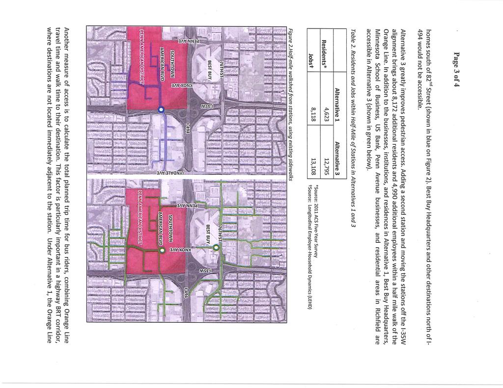
21 Page 21 The sketch layouts of the three most desired BRT station concepts (1A, 3A and 3B) were further refined to address construction limits, lane configurations and dimensions, transit station locations, utility impacts and right of way. The refined sketch layouts were developed to reduce the impacts to I-494 and I-35W and also establish a minimalist BRT Only layout for the improvements and cost estimates. Geometrics for the ramp connections and spacing between I-494 and 82 nd Street interchange match the existing conditions. The layouts for Concepts 3A and 3B, Knox Avenue Underpass, included a required relocation of an existing 42 inch watermain and stormwater drainage that requires routing storm sewer to the Penn Avenue pump station. The refined sketch layouts of these three concepts are included on the following pages. Planning level construction cost estimates were developed for the three concepts identified for further review. The estimates utilized MnDOT s basic Length-Width-Depth (LWD) worksheet format. Major construction elements were quantified along with unique project features and an estimate for right of way that includes property acquisition, access modifications and going concerns (per MN Stat ). The estimates also included a 20% Project Risk factor and 20% Engineering costs. An extra cost estimate was developed for Concept 3A to establish baseline costs for a Transit Only layout (Figure 9B) to aid in the identification of local cost participation amounts. The construction cost estimates for the three concepts are summarized as follows: Concepts Item 1A 3A Transit Only 3A Transit + GP 3B Roadway 10,500,000 1,200,000 1,500,000 10,700,000 Retaining Walls 0 1,900,000 1,900,000 3,400,000 Bridge 3,500,000 3,700,000 5,600,000 9,400,000 Transit Station 8,000,000 3,000,000 3,000,000 3,000,000 TMS & TSP 1,600, , ,000 1,800,000 Traffic Control 1,400,000 2,000,000 2,200,000 3,500,000 Utility/Drainage 300,000 6,300,000 6,300,000 6,600,000 Risk/Contingency 4,700,000 3,400,000 3,900,000 7,000,000 Engineering 5,700,000 4,000,000 4,500,000 8,500,000 TOTAL $ 35,700,000 25,600,000 29,000,000 53,900,000 Right of Way TBD Notes: Roadway Includes mainline, shoulder, trail/sidewalk, ADA ramps and grading. Retaining Walls Includes mainline and sidestreet retaining walls. Bridge Includes mainline bridge and ramps. Transit Station Includes structures, HVAC, vertical circulation, lighting, dynamic signing and amenities. TMS Includes reconstruction of I-35W Traffic Management System (TMS), new signal and/or Transit Signal Priority (TSP). Traffic Control Includes traffic control/management during construction. Utility/Drainage Includes utility and drainage relocations and improvements to accommodate improvements. Risk/Contingency Includes approximately 20% value of project costs for project risk. Engineering Includes approximately 20% value of project costs for preliminary and final design and construction engineering. Right of Way To Be Determined. It is expected that right of way costs will be a larger share of Concepts 3A or 3B than of Concept 1A. GP Denotes general purpose traffic lanes are included in the roadway configuration of Knox Avenue.
22 Page 22 Concept 1A Refined Layout Sketch - Online I-35W at American Blvd., South Edge
23 Page 23 Concept 3A Refined Layout Sketch - Offline Knox Ave. with I-494 underpass and 82 nd /76 th St. Access, TRANSIT + GENERAL PURPOSE TRAFFC
24 Page 24 Concept 3A Refined Layout Sketch - Offline Knox Ave. with I-494 underpass and 82 nd /76 th St. Access, TRANSIT ONLY TRAFFC
25 Page 25 Concept 3A Refined Layout Sketch - Offline Knox Ave. with I-494 underpass and 82 nd /76 th St. Access, PRELIMINARY DRAINAGE OPTION 1

26 Page 26 Concept 3A Refined Layout Sketch - Offline Knox Ave. with I-494 underpass and 82 nd /76 th St. Access, PRELIMINARY DRAINAGE OPTION 2
27 Page 27 Concept 3B Refined Layout Sketch - Offline Knox Ave. with I-494 Underpass and Bus Ramp to American Boulevard
28 Page 28 Public Involvement The process for development and evaluation of the BRT station concepts also involved public involvement efforts that included a project update at worksession meetings for the City Councils of both Bloomington and Richfield and a Public Open House meeting. The worksession presentations to the City Councils were conducted on September 23 rd and 24 th by representatives from MnDOT, Metro Transit and SEH. The presentations provided an update of the project objectives, schedule, interchange concepts under consideration (Turbine and Clovermill) and general overview of the BRT station locations (Online I-35W and Knox Avenue alignments). The Open House Meeting was held on October 3 rd at St. Richard s Catholic Church in Richfield. The meeting provided information to stakeholders on recent study activities and gathered input on the two interchange concepts, the BRT station alignments and potential station locations. More than 80 citizens attended the meeting, with sign-in and comments cards providing documentation of the meeting. Findings The BRT station portion of the I-494/I-35W Interchange Vision Layout Development study included the identification of viable BRT station concepts, evaluation of the concepts through agreed criteria and ratings and special analysis for service impacts which led to the selection of the three most desired station concepts: 1A - Online I-35W at American Blvd., South Edge 3A - Offline Knox Ave. with I-494 underpass and 82 nd /76 th St. Access 3B - Offline Knox Ave. with I-494 Underpass and Bus Ramp to American Boulevard The refinement of these three concepts, development of construction cost estimates, public involvement feedback and further review and discussion by both the TAG and TAC led to the determination of the most desired BRT station concept. The TAG has reviewed the information presented in this Technical Memorandum and through discussion at their meeting on Oct. 28 th, 2013 reached consensus that Concept 3A - Offline Knox Ave. with I-494 underpass and 82 nd /76 th St. Access is the most desired BRT station concept for inclusion in the Vision Layout for the improvements to the I-494/I-35W interchange. jcr Attachment: Service Impacts Analysis of American Boulevard Station Alternatives, Metro Transit s:\ko\m\mntmd\123252\4-prelim-dsgn-rprts\brt station tech memo\tech memo i-35w brt station amer blvd.docx
29 Technical Memorandum Appendix 1 Metro Transit Memorandum Service Impacts Analysis of American Boulevard Station Alternatives
30
31
32
33
METRO Orange Line BRT American Boulevard Station Options
 METRO Orange Line BRT American Boulevard Station Options Bloomington City Council Work Session November 18, 2013 Christina Morrison BRT/Small Starts Project Office Coordinating Planning and Design AMERICAN
Snelling Bus Rapid Transit. May 13, 2013 Technical Advisory Committee Meeting #1
 Snelling Bus Rapid Transit May 13, 2013 Technical Advisory Committee Meeting #1 1 Today s meeting TAC Introductions Project Overview Arterial BRT Concept Background Snelling Corridor Plan, Funding & Schedule
Metro Transit Update. Christina Morrison, Senior Planner Metro Transit BRT/Small Starts Project Office. John Dillery, Senior Transit Planner
 Metro Transit Update Christina Morrison, Senior Planner Metro Transit BRT/Small Starts Project Office John Dillery, Senior Transit Planner Metro Transit Service Development May 16, 2013 1 Transit Planning
I-35W Past, Present, and Future: METRO Orange Line
 I-35W Past, Present, and Future: METRO Orange Line 2018 State Public Transportation Partnerships Conference Charles Carlson Director, BRT Projects Metro Transit Charles.Carlson@metrotransit.org Metro Transit:
Orange Line Bus Rapid Transit Project Plan Update. Metro Transit June 2014 D R A F T
 Orange Line Bus Rapid Transit Metro Transit D R A F T Contents 1 Background 4 2 Scope 6 2.1 Mode 2.2 Stations 2.3 Guideway 2.4 Right of Way Needs 2.5 Technology 2.6 Fare Collection 2.7 Branding and Marketing
IMPROVEMENT CONCEPTS
 IMPROVEMENT CONCEPTS for the South Novato Transit Hub Study Prepared by: January 11, 2010 DKS Associates With Wilbur Smith Associates IMPROVEMENT CONCEPTS Chapter 1: Introduction 1. INTRODUCTION The strategic
Preliminary Definition of Alternatives. 3.0 Preliminary Definition of Alternatives
 3.0 What preliminary alternatives are being evaluated? The alternatives for the East San Fernando Valley Transit Corridor project that were considered for screening include the No Build Alternative, Transportation
6/6/2018. June 7, Item #1 CITIZENS PARTICIPATION
 June 7, 2018 Item #1 CITIZENS PARTICIPATION 1 Item #2 APPROVAL OF MINUTES Item #3 TRAC GOALS, FRAMEWORK & AGENDA REVIEW 2 COMMITTEE GOALS Learn about Southern Nevada s mobility challenges, new developments
Kendall Drive Premium Transit PD&E Study Project Kick-Off Meeting SR 94/Kendall Drive/SW 88 Street Project Development and Environment (PD&E) Study
 Study") Florida Department of Transportation District Six Kendall Drive Premium Transit PD&E Study Project Kick-Off Meeting SR 94/Kendall Drive/SW 88 Street Project Development and Environment (PD&E) Study What
Florida Department of Transportation District Six Kendall Drive Premium Transit PD&E Study Project Kick-Off Meeting SR 94/Kendall Drive/SW 88 Street Project Development and Environment (PD&E) Study What
State Avenue Corridor Bus Rapid Transit (BRT)
") State Avenue Corridor Bus Rapid Transit (BRT) Moving Forward Incrementally April 2010 State Ave. BRT Update Bus Rapid Transit Overview State Ave. Alternatives Analysis Results What s Coming Up Right Away!
State Avenue Corridor Bus Rapid Transit (BRT) Moving Forward Incrementally April 2010 State Ave. BRT Update Bus Rapid Transit Overview State Ave. Alternatives Analysis Results What s Coming Up Right Away!
STH 60 Northern Reliever Route Feasibility Study Report
 #233087 v3 STH 60 Northern Reliever Route Feasibility Study Report Washington County Public Works Committee Meeting September 28, 2016 1 STH 60 Northern Reliever Route Feasibility Study Hartford Area Development
Waco Rapid Transit Corridor (RTC) Feasibility Study
 Feasibility Study") Waco Rapid Transit Corridor (RTC) Feasibility Study Chris Evilia, Director of Waco Metropolitan Planning Organization Allen Hunter, General Manager Waco Transit System Jimi Mitchell, Project Manager AECOM
Waco Rapid Transit Corridor (RTC) Feasibility Study Chris Evilia, Director of Waco Metropolitan Planning Organization Allen Hunter, General Manager Waco Transit System Jimi Mitchell, Project Manager AECOM
Troost Corridor Transit Study
 Troost Corridor Transit Study May 23, 2007 Kansas City Area Transportation Authority Agenda Welcome Troost Corridor Planning Study Public participation What is MAX? Survey of Troost Riders Proposed Transit
Public Meeting. City of Chicago Department of Transportation & Department of Housing and Economic Development
 Public Meeting City of Chicago Department of Transportation & Department of Housing and Economic Development Funded by Regional Transportation Authority September 12, 2011 In partnership with Presentation
FREQUENTLY ASKED QUESTIONS
 THE PROJECT Last updated on 9/8/16 FREQUENTLY ASKED QUESTIONS What s happening on Highway 169? The Minnesota Department of Transportation (MnDOT) is planning to rebuild and repair the infrastructure on
Location Concept Plan Amendment Recommendation Approved 2011 Concept Plan
 Valley Line West LRT Concept Plan Recommended Amendments Lewis Farms LRT Terminus Site Location Concept Plan Amendment Recommendation Approved 2011 Concept Plan Lewis Farms LRT terminus site, 87 Avenue/West
FREQUENTLY ASKED QUESTIONS
 THE PROJECT Last updated on 2/19/16 FREQUENTLY ASKED QUESTIONS What s happening on Highway 169? The Minnesota Department of Transportation (MnDOT) is planning to rebuild and repair the infrastructure on
Business Advisory Committee. July 7, 2015
 Business Advisory Committee July 7, 2015 1 Today s Topics Outreach Update TI #1 and 2: Target Field Station Connection to I-94: Recommendation 85 th Station Configuration 93 rd Station Configuration DEIS
I-405 and SR 522/NE 145th Bus Rapid Transit. Elected Leadership Groups Meeting November 30, 2018
 I-405 and SR 522/NE 145th Bus Rapid Transit Elected Leadership Groups Meeting November 30, 2018 Agenda Welcome and Introductions Public Comment BRT Connection in Bothell Common Elements: Bus base, Station
ACTION TRANSMITTAL No
 Transportation Advisory Board of the Metropolitan Council of the Twin Cities DATE: January 4, 2016 TO: ACTION TRANSMITTAL No. 2016-19 TAC Funding and Programming Committee PREPARED BY: Joe Barbeau, Senior
Executive Summary. Treasure Valley High Capacity Transit Study Priority Corridor Phase 1 Alternatives Analysis October 13, 2009.
 Treasure Valley High Capacity Transit Study Priority Corridor Phase 1 Alternatives Analysis October 13, 2009 Background As the Treasure Valley continues to grow, high-quality transportation connections
BROWARD BOULEVARD CORRIDOR TRANSIT STUDY
 BROWARD BOULEVARD CORRIDOR TRANSIT STUDY FM # 42802411201 EXECUTIVE SUMMARY July 2012 GOBROWARD Broward Boulevard Corridor Transit Study FM # 42802411201 Executive Summary Prepared For: Ms. Khalilah Ffrench,
Pacific Electric Right-of-Way / West Santa Ana Branch Corridor Alternatives Analysis
 Pacific Electric Right-of-Way / West Santa Ana Branch Corridor Alternatives Analysis Transit Coalition September 26, 2012 2 Study Area Pacific Electric Rightof-Way/West Santa Ana Branch (PEROW/ WSAB) extends
5. OPPORTUNITIES AND NEXT STEPS
 5. OPPORTUNITIES AND NEXT STEPS When the METRO Green Line LRT begins operating in mid-2014, a strong emphasis will be placed on providing frequent connecting bus service with Green Line trains. Bus hours
Committee Report. Transportation Committee. Business Item No
 Committee Report Business Item No. 2015-280 Transportation Committee For the Metropolitan Council meeting of December 9, 2015 Subject: METRO Blue Line Extension (Bottineau Light Rail Transit) Revised Scope
CTA Blue Line Study Area
 CTA Blue Line Study Area HISTORY OF THE CTA BLUE LINE / I-290 SYSTEM Blue Line / I-290 infrastructure is 55 years old First integrated transit / highway facility in the U.S. PROJECT STUDY AREA EXISTING
CEDAR AVENUE TRANSITWAY Implementation Plan Update
 CEDAR AVENUE TRANSITWAY Implementation Plan Update EECUTIVE SUMMARY DECEMBER 2015 Executive Summary In 2013, the Twin Cities metropolitan area s first bus rapid transit (BRT) line, the METRO Red Line,
I-820 (East) Project Description. Fort Worth District. Reconstruct Southern I-820/SH 121 Interchange
 Project Description. Fort Worth District. Reconstruct Southern I-820/SH 121 Interchange") I-820 (East) Project Description Fort Worth District Reconstruct Southern I-820/SH 121 Interchange I-820 from approximately 2,000 feet north of Pipeline Road/Glenview Drive to approximately 3,200 feet
I-820 (East) Project Description Fort Worth District Reconstruct Southern I-820/SH 121 Interchange I-820 from approximately 2,000 feet north of Pipeline Road/Glenview Drive to approximately 3,200 feet
Restoration of Historic Streetcar Services in Downtown Los Angeles
 Restoration of Historic Streetcar Services in Downtown Los Angeles Early Scoping Meeting for Alternatives Analysis (AA) May 17, 2011 Introduction Key players Local lead agency: Metro Federal lead agency:
I-10 West AA/EIS Pre-Screening and Tier 1 Analysis Results. Public Meeting. Wulf Grote, Director Project Development Rick Pilgrim, Project Manager
 I-10 West AA/EIS Pre-Screening and Tier 1 Analysis Results Public Meeting Wulf Grote, Director Project Development Rick Pilgrim, Project Manager March 4 & 5, 2008 Today s Agenda Overview of Alternatives
Community Advisory Committee. October 5, 2015
 Community Advisory Committee October 5, 2015 1 Today s Topics Hennepin County Community Works Update Project Ridership Estimates Technical Issue #4:Golden Valley Rd and Plymouth Ave Stations Technical
Draft Results and Open House
 Waco Rapid Transit Corridor (RTC) Feasibility Study Draft Results and Open House Chris Evilia, Director of Waco Metropolitan Planning Organization Allen Hunter, General Manager Waco Transit System Jimi
Highway Transitway Corridor Study
 Highway Transitway Corridor Study Technical Memorandum 3: Corridor Concepts and Evaluation Prepared for: Metropolitan Council May 2014 SRF No. 7994 Table of Contents Introduction... 1 Concept Development...
Chapter 7: Travel Demand Analysis. Chapter 8. Plan Scenarios. LaSalle Community Center. Image Credit: Town of LaSalle
 Chapter 7: Travel Demand Analysis Chapter 8 Plan Scenarios LaSalle Community Center. Image Credit: Town of LaSalle 164 Chapter 8: Plan Scenarios Moving Ahead for Progress in the 21 st Century Act (MAP
ANDERSON PROPERTY SITE ANALYSIS
 ANDERSON PROPERTY SITE ANALYSIS Introduction The Montgomery County Department of Transportation (MCDOT) initiated a feasibility study in the fall of 2012 to evaluate the need for transit service expansion
METRO Light Rail Update
 American Society of Highway Engineers METRO Light Rail Update Brian Buchanan Director, Design and Construction October 13, 2009 1 High Capacity Transit System 2 20-Mile Light Rail Line 3 Operations Operations
Transitways. Chapter 4
 4 Transitways Figure 4-1: Hiawatha LRT Train at the Lake Street/Midtown Station The 23 Transportation Policy Plan identifies a network of transitway corridors to be implemented by 23. Transitways recommended
Metropolitan Freeway System 2013 Congestion Report
 Metropolitan Freeway System 2013 Congestion Report Metro District Office of Operations and Maintenance Regional Transportation Management Center May 2014 Table of Contents PURPOSE AND NEED... 1 INTRODUCTION...
Railyard Alternatives & I-280 Boulevard Feasibility Study 1 RAILYARD ALTERNATIVES & I-280 BOULEVARD (RAB) FEASIBILITY STUDY
 FEASIBILITY STUDY") Railyard Alternatives & I-280 Boulevard Feasibility Study 1 RAILYARD ALTERNATIVES & I-280 BOULEVARD (RAB) FEASIBILITY STUDY RAB Citizen Working Group Meeting, August 1 st 2016 CITIZEN WORKING GROUP (CWG)
Railyard Alternatives & I-280 Boulevard Feasibility Study 1 RAILYARD ALTERNATIVES & I-280 BOULEVARD (RAB) FEASIBILITY STUDY RAB Citizen Working Group Meeting, August 1 st 2016 CITIZEN WORKING GROUP (CWG)
EUGENE-SPRINGFIELD, OREGON EAST WEST PILOT BRT LANE TRANSIT DISTRICT
 EUGENE-SPRINGFIELD, OREGON EAST WEST PILOT BRT LANE TRANSIT DISTRICT (BRIEF) Table of Contents EUGENE-SPRINGFIELD, OREGON (USA)... 1 COUNTY CONTEXT AND SYSTEM DESCRIPTION... 1 SYSTEM OVERVIEW... 1 PLANNING
SOUTHERN GATEWAY. Transportation and Trinity River Project Committee 11 May 2015
 SOUTHERN GATEWAY Transportation and Trinity River Project Committee 11 May 2015 Southern Gateway Project History Began in 2001 as a Major Investment Study [ MIS ], Schematic, and Environmental Assessment
FINAL. Sound Transit Long-Range Plan Update. Issue Paper S.1: Tacoma Link Integration with Central Link. Prepared for: Sound Transit
 Sound Transit Long-Range Plan Update Issue Paper S.1: Tacoma Link Integration with Central Link Prepared for: Sound Transit Prepared by: Quade & Douglas, Inc. FINAL March 2005 Foreword This issue paper
King County Metro. Columbia Street Transit Priority Improvements Alternative Analysis. Downtown Southend Transit Study. May 2014.
 King County Metro Columbia Street Transit Priority Improvements Alternative Analysis Downtown Southend Transit Study May 2014 Parametrix Table of Contents Introduction... 1 Methodology... 1 Study Area...
Bi-County Transitway/ Bethesda Station Access Demand Analysis
 Bi-County Transitway/ Bethesda Station Access Demand Analysis Prepared for: Washington Metropolitan Area Transit Authority Office of Planning and Project Development May 2005 Prepared by: in conjunction
D Line Station Plan: Table of Contents
 Final Station Plan This document identifies D Line station locations for approval by the Metropolitan Council in summer 2018. It is a final revision of the D Line Station Plan previously published for
Sound Transit East Link: Bus/LRT System Integration Study
 Sound Transit East Link: Bus/LRT System Integration Study Prepared For: Sound Transit King County Metro Mercer Island WSDOT Prepared By: CH2M HILL July, 2014 1 SOUND TRANSIT EAST LINK: BUS/LRT SYSTEMES
US 29 Bus Rapid Transit Planning Board Briefing. February 16, 2017
 US 29 Bus Rapid Transit Planning Board Briefing February 16, 2017 Project Goals Improve the quality of transit service Improve mobility opportunities and choices Enhance quality of life Support master
Transportation Highway Engineering Conference February 24, 2015
 Transportation Highway Engineering Conference February 24, 2015 Today s Agenda Move Illinois status Jane Addams Memorial (I-90) Rebuilding and Widening Project Building a 21 st century corridor Incorporating
Welcome The City has undertaken a naming exercise for the existing and future LRT lines. The SE to West LRT, as the project has been called to date,
 Welcome The City has undertaken a naming exercise for the existing and future LRT lines. The SE to West LRT, as the project has been called to date, is now called the Valley Line. We are here to present
6/11/2018. June 7, Item #1 CITIZENS PARTICIPATION
 June 7, 2018 Item #1 CITIZENS PARTICIPATION 1 Item #2 APPROVAL OF MINUTES Item #3 TRAC GOALS, FRAMEWORK & AGENDA REVIEW 2 COMMITTEE GOALS Learn about Southern Nevada s mobility challenges, new developments
WELCOME. Transit Options Amherst - Buffalo Public Workshops
 WELCOME Transit Options Amherst - Buffalo Public Workshops Sponsored by Niagara Frontier Transportation Authority Greater Buffalo Niagara Regional Transportation Council Where do you live? Where do you
4.0 TIER 2 ALTERNATIVES
 4.0 TIER 2 ALTERNATIVES The Tier 2 Alternatives represent the highest performing Tier 1 Alternatives. The purpose of the Tier 2 Screening was to identify the LPA utilizing a more robust list of evaluation
Denver Metro Association of Realtors
 Denver Metro Association of Realtors North Metro Rail Line October 2, 2014 1 The RTD FasTracks Plan 122 miles of new light rail and commuter rail 18 miles of Bus Rapid Transit (BRT) service 31 new Park-n-Rides;
Point A Point B Point C Point D. Fulton County Board of Commissioners and Mayors Meeting December 14, 2017
 Fulton County Board of Commissioners and Mayors Meeting December 14, 2017 Master Plan Overview Phase 1 Community Vision and Existing Transit Conditions Phase 2 Scenario Development Phase 3 Transit Master
West Broadway Reconstruction/LRT Design. March 19, 2015
 West Broadway Reconstruction/LRT Design March 19, 2015 1 Meeting Agenda 6:05 6:30 PM Brief presentation What we heard Project overview 6:30 8:00 PM Visit Six Topic Areas Road and LRT design elements Pedestrian
I-20 EAST TRANSIT INITIATIVE Tier 1 and Tier 2 Alternatives Screening Report EXECUTIVE SUMMARY
 EXECUTIVE SUMMARY The purpose of this report is to document the results of the Tier 1 and Tier 2 Screening of alternatives for the I-20 East Transit Initiative. The two-tier screening process presented
Recommended Station Plan
 Recommended Station Plan Comments on this recommended D Line Station Plan can be submitted to dline@metrotransit.org through June 8, 2018. This document identifies D Line station locations recommended
Midtown Corridor Alternatives Analysis Capital Cost Estimation Methodology and Assumptions
 Midtown Corridor Alternatives Analysis Capital Cost Estimation Methodology and Assumptions 1/3/2014 Prepared by the SRF Consulting Group Team for Table of Contents Introduction... 1 Alternatives Overview...
Restoration of Historic Streetcar Services in Downtown Los Angeles
 Restoration of Historic Streetcar Services in Downtown Los Angeles Alternatives Analysis Community Update Meeting August 2, 2011 Introduction Key players Local lead agency: Metro Federal lead agency: Federal
Table of Contents INTRODUCTION... 3 PROJECT STUDY AREA Figure 1 Vicinity Map Study Area... 4 EXISTING CONDITIONS... 5 TRAFFIC OPERATIONS...
 Crosshaven Drive Corridor Study City of Vestavia Hills, Alabama Table of Contents INTRODUCTION... 3 PROJECT STUDY AREA... 3 Figure 1 Vicinity Map Study Area... 4 EXISTING CONDITIONS... 5 TRAFFIC OPERATIONS...
The Eastern Connector Study November, 2007 planning for the future
 The Eastern Connector Study November, 2007 planning for the future In late 2006, Albemarle County and the City of Charlottesville jointly initiated the Eastern Connector Corridor Study. The Project Team
Hennepin County Transit Oriented Development Program. The Ellipse, St. Louis Park, 2009
 Hennepin County Transit Oriented Development Program The Ellipse, St. Louis Park, 2009 What is Transit Oriented Development (TOD)? Development within walking distance of transit Typically ¼ to ½ mile 10
BOARD OF SUPERVISORS BUSINESS MEETING ACTION ITEM. Design Endorsement for Sterling Boulevard Extension
 Date of Meeting: July 20, 2017 # 6 BOARD OF SUPERVISORS BUSINESS MEETING ACTION ITEM SUBJECT: ELECTION DISTRICT: CRITICAL ACTION DATE: STAFF CONTACTS: Design Endorsement for Sterling Boulevard Extension
Develop ground transportation improvements to make the Airport a multi-modal regional
 Project Overview TRANSPORTATION IMPROVEMENTS WHAT ARE THE PROJECT GOALS? Transportation transportation hub. Develop ground transportation improvements to make the Airport a multi-modal regional Land Use
Key Transfer Stations - Technical Memo
 DOCUMENT 5 October 2008 Key - Technical Memo 1.0 INTRODUCTION In May 2008 Council approved a Primary Rapid Transit Network which includes both Light Rail Transit (LRT) and Bus Rapid Transit (BRT) corridors.
Alternatives Analysis Findings Report
 6.0 This chapter presents estimates of the potential capital, operations and maintenance costs associated with the alternatives carried forward for detailed evaluation. The methodology used to develop
Letter EL652 City of Mercer Island. Page 1. No comments n/a
 Letter EL652 City of Mercer Island Page 1 No comments n/a Page 2 Response to comment EL652 1 Section 4.5.3 of the Final EIS presents the range of potential impacts of the project. This project also lists
Challenges in a Post-Katrina Environment East-West Corridor Project Overview February, 2007
 EAST-WEST CORRIDOR Challenges in a Post-Katrina Environment East-West Corridor Project Overview February, 2007 Presentation Agenda Project Overview / Purpose and Need Highway Component Transit Component
West LRT. Alignment Update and Costing Report May Calgary Transit Transportation Planning Clifton ND Lea Consultants
 West LRT Alignment Update and Costing Report 2006 May Calgary Transit Transportation Planning Clifton ND Lea Consultants West LRT Update Background The service area for West LRT is generally described
Clearlake Road (State Road 501) Project Development & Environment (PD&E) Study
 Project Development & Environment (PD&E) Study") Clearlake Road (State Road 501) Project Development & Environment (PD&E) Study FROM MICHIGAN AVENUE TO INDUSTRY ROAD BREVARD COUNTY, FLORIDA Financial Project ID No: 433605-1-22-01 Federal Aid Project
Clearlake Road (State Road 501) Project Development & Environment (PD&E) Study FROM MICHIGAN AVENUE TO INDUSTRY ROAD BREVARD COUNTY, FLORIDA Financial Project ID No: 433605-1-22-01 Federal Aid Project
Midtown Corridor Alternatives Analysis Key Issues Memo
 Midtown Corridor Alternatives Analysis Key Issues Memo 1/4/2013 Prepared by the SRF Consulting Group Team for Table of Contents Introduction... 1 1. Markets... 1 External Markets... 1 Intra-Corridor Travel...
Brigham City 1200 West Box Elder Creek Bridge - Widening Project Type Reconstruction
 Brigham City 1200 West Box Elder Creek Bridge - Widening Project Type Reconstruction 550 North to 650 North $ 1,750,000 $ 1,582,113 To widen an existing bridge on 1200 West over Box Elder Creek that will
Service Quality: Higher Ridership: Very Affordable: Image:
 Over the past decade, much attention has been placed on the development of Bus Rapid Transit (BRT) systems. These systems provide rail-like service, but with buses, and are typically less expensive to
Note: The October 2007 version of this report has been updated in this December 2008 report to present costs in year 2007 dollars.
 Sound Transit Phase 2 South Corridor LRT Design Report: SR 99 and I-5 Alignment Scenarios (S 200 th Street to Tacoma Dome Station) Tacoma Link Extension to West Tacoma Prepared for: Sound Transit Prepared
Harlem Avenue between 63 rd and 65 th
 Harlem Avenue between 63 rd and 65 th Public Meeting #2 March 13, 2018 Summit Park District Welcome to the second Public Meeting for the preliminary engineering and environmental studies of Illinois 43
Draft Results and Recommendations
 Waco Rapid Transit Corridor (RTC) Feasibility Study Draft Results and Recommendations Chris Evilia, Director of Waco Metropolitan Planning Organization Allen Hunter, General Manager Waco Transit System
The Engineering Department recommends Council receive this report for information.
 CORPORATE REPORT NO: R161 COUNCIL DATE: July 23, 2018 REGULAR COUNCIL TO: Mayor & Council DATE: July 19, 2018 FROM: General Manager, Engineering FILE: 8740-01 SUBJECT: Surrey Long-Range Rapid Transit Vision
Tempe Streetcar. March 2, 2016
 Tempe Streetcar March 2, 2016 Tempe Profile 40 sq. miles, highest density in state University Town, center of region Imposed growth boundaries (density increase) Mixed use growth/intensifying land use
Maryland Gets to Work
 I-695/Leeds Avenue Interchange Reconstruction Baltimore County Reconstruction of the I-695/Leeds Avenue interchange including replacing the I-695 Inner Loop bridges over Benson Avenue, Amtrak s Northeast
Interstate Operations Study: Fargo-Moorhead Metropolitan Area Simulation Results
 NDSU Dept #2880 PO Box 6050 Fargo, ND 58108-6050 Tel 701-231-8058 Fax 701-231-6265 www.ugpti.org www.atacenter.org Interstate Operations Study: Fargo-Moorhead Metropolitan Area 2025 Simulation Results
August 2, 2010 Public Meeting
 Public Meeting LYMMO Expansion Alternatives Analysis Study Purpose of study is to provide a fresh look at potential LYMMO expansion, following Federal Transit Administration (FTA) Alternatives Analysis
What We Heard Report - Metro Line NW LRT
 What We Heard Report - Metro Line NW LRT by Metro Line NW LRT Project Team LRT Projects City of Edmonton April 11, 2018 Project / Initiative Background Name Date Location Metro Line Northwest Light Rail
Interstate Operations Study: Fargo-Moorhead Metropolitan Area Simulation Output
 NDSU Dept #2880 PO Box 6050 Fargo, ND 58108-6050 Tel 701-231-8058 Fax 701-231-6265 www.ugpti.org www.atacenter.org Interstate Operations Study: Fargo-Moorhead Metropolitan Area 2015 Simulation Output Technical
Welcome. Green Line in Your Community
 Welcome Green Line in Your Community Today's session will provide you with information about Administration's recommendation for connecting the Green Line in the Beltline to Victoria Park and Inglewood/Ramsay
CITY OF ANN ARBOR, MICHIGAN 301 E. Huron St., P.O. Box 8647 Ann Arbor, Michigan
 Date: Wednesday, June 24, 2014 Location: Ann Arbor District Library Attendees: 40 citizen attendees Ann Arbor Station Environmental Review Public Meeting Meeting Notes Meeting #2 The second public meeting
2016 Congestion Report
 2016 Congestion Report Metropolitan Freeway System May 2017 2016 Congestion Report 1 Table of Contents Purpose and Need...3 Introduction...3 Methodology...4 2016 Results...5 Explanation of Percentage Miles
Dixie Transportation Planning Office
 A project must be given a yes rating on items 1 & 2 in order to be prioritized. Sponsor: St. George City Project: Pioneer Parkway Type: Road Widening and Reconstruction Rev. 9/17/2010 Dixie Transportation
Executive Summary. Draft Environmental Impact Statement/Environmental Impact Report ES-1
 Executive Summary Introduction The Eastside Transit Corridor Phase 2 Project is a vital public transit infrastructure investment that would provide a transit connection to the existing Metro Gold Line
Open House. Highway212. Meetings. Corridor Access Management, Safety & Phasing Plan. 5:30 to 6:30 p.m. - Southwest Corridor Transportation Coalition
 Welcome Meetings 5:30 to 6:30 p.m. - Southwest Corridor Transportation Coalition 6:30 to 8:00 p.m. - Open House Why is Highway 212 Project Important? Important Arterial Route Local Support Highway 212
5 VAUGHAN METROPOLITAN CENTRE AND SURROUNDING AREAS TRANSPORTATION STUDY PROGRESS
 5 VAUGHAN METROPOLITAN CENTRE AND SURROUNDING AREAS TRANSPORTATION STUDY PROGRESS The Transportation Services Committee recommends the adoption of the recommendations contained in the following report
ACTION TRANSMITTAL
 Transportation Advisory Board of the Metropolitan Council of the Twin Cities DATE: February 12, 2014 TO: FROM: PREPARED BY: SUBJECT: REQUESTED ACTION: RECOMMENDED MOTION: ACTION TRANSMITTAL 2014-14 Transportation
Arterial Bus Rapid Transit. System Policy Oversight Committee April 7, 2014
 Arterial Bus Rapid Transit System Policy Oversight Committee April 7, 2014 1 Meeting Agenda Welcome and Introductions A Line - Project Status Shelter and Pylon Development Arterial BRT Branding Update
Northeast Corridor Alternatives Analysis. Public Involvement Round 2 Input on Alternatives for Further Study
 Northeast Corridor Alternatives Analysis Public Involvement Round 2 Input on Alternatives for Further Study Feb. 7-9, 2012 Agenda Review project background Progress summary Recommended alternatives for
Welcome. Public Open House Schedule. Super 8 West Kelowna 1655 Westgate Rd, West Kelowna. West Kelowna. Wednesday, March 2, :00 p.m. 8:00 p.m.
 Welcome Thank you for attending this Community Engagement on improvements to the Boucherie Road and Westlake Road intersections on Highway 97 in the Central Okanagan. Public Open House Schedule Location
What is the Connector?
 What is the Connector? The Connector is a plan for a high-capacity transit system from northeast to south Ann Arbor, connecting major destinations including downtown, commercial, and residential areas,
DRAFT Subject to modifications
 TREASURE COAST REGIONAL PLANNING COUNCIL M E M O R A N D U M DRAFT To: Council Members AGENDA ITEM 7A From: Date: Subject: Staff September 17, 2010 Council Meeting High Speed Rail Update Introduction The
East San Fernando Valley Transit Corridor. TAC Briefing December 4, 2013
 East San Fernando Valley Transit Corridor TAC Briefing December 4, 2013 Overview Measure R Project Long Range Transportation Plan Reserves $170.1 Million 2018 Revenue Operations Date Coordination with
What IS BRT, Really? Not BRT and RNY
 What IS BRT, Really? 2007 Winter TexITE Meeting Presented by Jeff Arndt, TTI Not BRT and RNY 1 What is Bus Rapid Transit? A flexible, rubber-tired from of rapid transit that combines stations, vehicles,
Energy Technical Memorandum
 Southeast Extension Project Lincoln Station to RidgeGate Parkway Prepared for: Federal Transit Administration Prepared by: Denver Regional Transportation District May 2014 Table of Contents Page No. Chapter
Reston Transportation Strategy July 9, 2018
 Reston Transportation Strategy July 9, 2018 Background: On February 11, 2014, the Board of Supervisors adopted the Reston Phase I Comprehensive Plan Amendment for the core areas of Reston between Sunset