Hawaii Fire Risk Mapping Project
|
|
|
- Charlene Rodgers
- 6 years ago
- Views:
Transcription

1 HIGICC Conference September 24, 2009 Hawaii Fire Risk Mapping Project Rich Nezelek, Sr. Imagery Analyst Chris Chiesa, Chief Information Officer Pacific Disaster Center
2 Presentation Overview Pacific Disaster Center Mission Support to Hawaii Fire Community Big Island (Hawaii County) Fire Fuels Mapping and Risk Mapping Project


3 PDC Mission Provide applied information research and analysis support for the development of more effective policies, institutions, programs and information products for the disaster management and humanitarian assistance communities of the Asia Pacific region and beyond.


4 Our Center Applied Science & Technology Information Products Supporting: Policy & Decision Makers, Disaster Managers Humanitarian Assistance Observation Systems /Data Advanced Applications, Algorithms, Models Integrating Information, Science, Technology Improve Decision- Support Capabilities GIS,, Visualization and Display Systems Communication Systems and Networks

5 Hawai i Natural Hazards and Vulnerabilities Atlas Local level data: Hawaii natural hazards and R & V data including: Lava flows, FEMA flood zones, hazardous dams Emergency services including: Police and fire stations, hospitals, shelters Public facilities including: Schools, hotels, banks Transportation networks including: Airports, seaports, bridges Elevation data including: Shaded relief, 500 foot contours

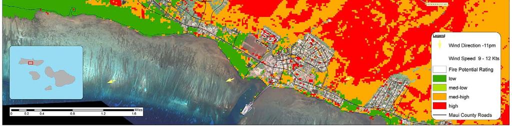
6 Fire Risk Assessment & Mapping


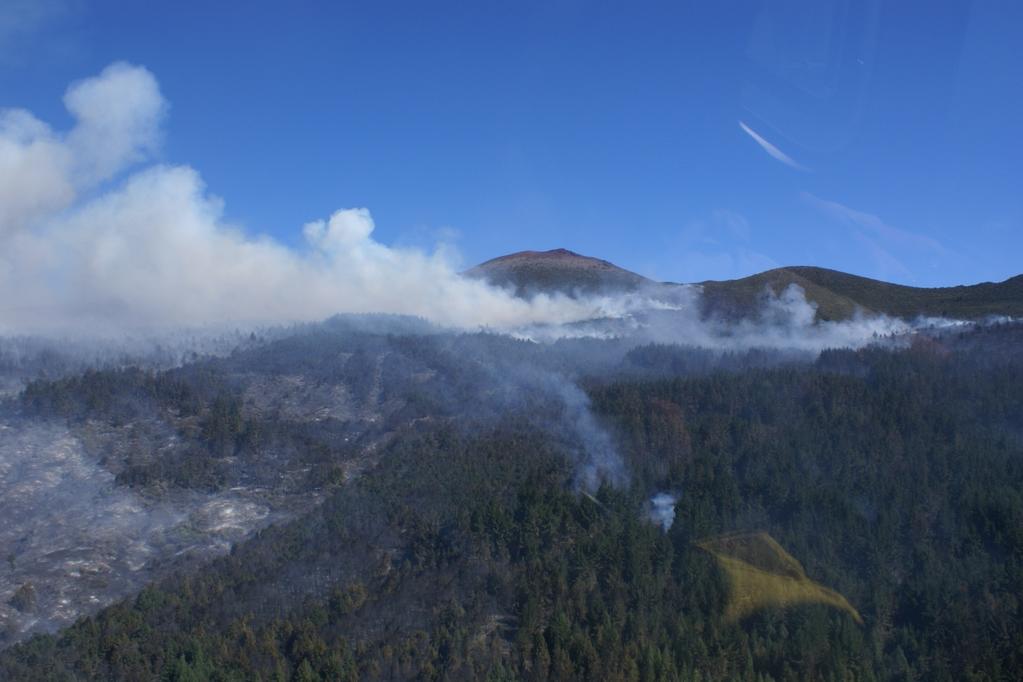
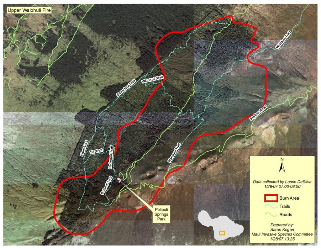
7 Polipoli Fire (Maui) January 2007


8 Fire risk to a community is complex and results from multiple factors, including: Fuels, Land use, and Weather Cycles The identification/modification of fuel types for Hawaii permits improved fire hazard analysis by Planning, Fire and Civil Defense personnel. The work in Hawaii Country builds on previous projects completed for Maui and Kauai Counties.
9 HAWAII COUNTY Fire Hazard Mapping and Urban/Wildland Risk Assessment The objectives of the Fire Hazard Mapping and Urban/Wildland Risk Assessment support multiple goals: Assisting the Fire Agencies by providing higher-resolution, more up-to date fire fuels & risk maps to support short-term prevention & mitigation projects. Providing fire risk data to Hawaii County for use in assessing Urban/Wildland Risk areas for as part of overall long-term planning processes
10 HAWAII COUNTY Fire Hazard Mapping and Urban/Wildland Risk Assessment The Hawaii County Hazard Mapping and Wildland/Urban Risk Assessment uses several GIS layers in its process of determining Fire Hazards and Risk. The following list includes data typical of this process: Fire Fuels Map this initial map has been created between PDC and the assistance of Hawaii County Fire Departments, leveraging recently created NOAA landcover data Spread Component Data related to Fuels Ignition Component Data related to Fuels Slope Data Derived from 10M DEM Elevation Data Aspect Data Derived from 10M DEM Elevation Data Hawaii County Development Data Parcel Zoning by Community Plan Parcel Landuse Type

11 PROCESS STEPS Step 1. Fire Fuels Map The Fuels map has several c components related to Fuel Type: Spread Component (SC) Energy Release Component (ERC) Burn Index (BI) and Ignition Component (IC)
")
12 PROCESS STEPS Step 1. Fire Fuels Map The Fuels map has several components related to Fuel Type: Spread Component (SC) Energy Release Component (ERC) Burn Index (BI) and Ignition Component (IC)

13 PROCESS STEPS Fire Fuels Map Since the Spread Component and Ignition Component give the best indication of potential fire hazard, these two indicators are used as the primary means of representing Fire Fuels Hazards
14 Fire Fuels Map Spread Component Data related to Fuels Create a SC Grid by re-classing the Updated Fuels Map using the Spread Component Values indicated in the chart. PROCESS STEPS

15 Fire Fuels Map Ignition Component Data related to Fuels Create an IC Grid by re-classing the Updated Fuels Map using the Spread Component Values indicated in the chart. PROCESS STEPS

16 Step 2. Terrain Inputs - Derived from a 10 meter DEM of Hawaii County. The two necessary elements are Slope and Aspect PROCESS STEPS

17 PROCESS STEPS Step 2. Terrain Inputs - Derived from a 10 meter DEM of Hawaii County. The two necessary elements are Slope and Aspect Create Slope from the 10M DEM and reclassify the grid as follows:: Slope % Rating 0-5 Mild Moderate Steep Extreme 4 Reclass Value

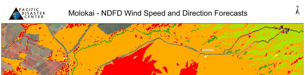
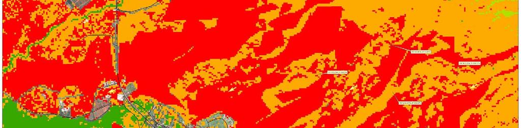
18 Step 2. Terrain Inputs - Derived from a 10 meter DEM of Hawaii County. The two necessary elements are Slope and Aspect Create Aspect from the 10M DEM and reclassify the grid as follows:: PROCESS STEPS Aspect Ratin g Direction N NE E SE S SW W NW N -1 0 Flat The Aspect grid is re-classed to reflect normal Trade Winds. This grid can also be re-classed to reflect Kona winds be reversing the rating. Similarly, these can adjusted to reflect any wind pattern the user may want to assess.


19 PROCESS STEPS Fire Risk Map Application for ArcView Allows for user selected grids to be used in generating Fire Risk Maps fro a variety of climate and weather conditions Select Climate Select Data Select Weather Run the App
20 Step 3. Combining Hazard Grids A Fire Hazard Map can now be generated by combining the four grids. Multiply the grids together as follows: Spread Component Ignition Component Slope Component Aspect Component PROCESS STEPS
21 Additional Capabilities / Next Steps One of the key opportunties of this process and resultant data is the opportunity to establish processes to regularly update the Fuels Map and Fire Hazard Map, and even extend to a Development Risk Map at a parcel- or neighborhood level. For example: 1. Tracking and updating changes to the landscape based on new or proposed developments. In assessing the location, scope and type of new development, the Country can update the Fire Fuels Map and incorporate with planned develop to create a Development Risk Map to assess urban/wildland fire risks. 2. Tracking and updating changes in Fire Fuels type based on mitigation or prevention actions taken by Fire Agencies, as well as impacts by natural or human caused fires. 3. Tracking changes in cultivated lands, including tasks such as the ability to adjust the Fire Fuels Map relative to which cane fields are bare, fallow or actively growing agriculture. This would allow the ability to analyze where fire risk may be greater due to cane fields adjacent to existing Fire Fuels or Development Risk areas.
22
23 Chris Chiesa Rich Nezelek Pacific Disaster Center Mahalo!
Institutionalizing Early Warning Systems
 2017/SOM1/EPWG/025 Agenda Item: 7.3.2 Institutionalizing Early Warning Systems Purpose: Information Submitted by: PDC 11 th Emergency Preparedness Working Group Meeting Nha Trang, Viet Nam 18-19 February
WIND MAP. United States
 Special Wind Region (Consult Local Authorities) LOCATION V mph (m/s) Hawaii 105 (47) Puerto Rico 145 (65) Guam 170 (76) Virgin Islands 145 (65) American Samoa 125 (56) Notes: 1. Values are nominal design
MEETING GOVERNMENT MANDATES TO REDUCE FLEET SIZE
 H O W W I R E L E S S F L E E T M A N A G E M E N T C A N H E L P E X C E E D F L E E T O P T I M I Z AT I O N G O A L S Table of Contents 3 4 4 5 5 6 6 6 8 8 Overview Using Wireless Fleet Management to
Parking Management Element
 Parking Management Element The State Transportation Planning Rule, adopted in 1991, requires that the Metropolitan Planning Organization (MPO) area implement, through its member jurisdictions, a parking
Challenges in a Post-Katrina Environment East-West Corridor Project Overview February, 2007
 EAST-WEST CORRIDOR Challenges in a Post-Katrina Environment East-West Corridor Project Overview February, 2007 Presentation Agenda Project Overview / Purpose and Need Highway Component Transit Component
July 24, Rhode Island Transportation Innovation Partnership AUTONOMOUS VEHICLE MOBILITY CHALLENGE
 Rhode Island Transportation Innovation Partnership AUTONOMOUS VEHICLE MOBILITY CHALLENGE Accent image here Primary Image here Julia Gold, Chief of Sustainability and Innovation Rhode Island Department
Category V. Criterion 5H: Hazardous Materials (Hazmat)
") Category V Criterion 5H: Hazardous Materials (Hazmat) The agency operates an adequate, effective, efficient, and safe hazardous materials program directed toward protecting the community from the hazards
Category V Criterion 5H: Hazardous Materials (Hazmat) The agency operates an adequate, effective, efficient, and safe hazardous materials program directed toward protecting the community from the hazards
ENERGY CONSERVATION USING VARIABLE-FREQUENCY DRIVES FOR CENTER PIVOT IRRIGATION
 Proceedings of the 29th Annual Central Plains Irrigation Conference, Burlington, Colorado, Feb. 21-22, 2017 Available from CPIA, 760 N. Thompson, Colby, Kansas ENERGY CONSERVATION USING VARIABLE-FREQUENCY
Weathering the Storm: How You Can Prepare your Fleet for Emergencies QUICK GUIDE. Weathering the Storm: How You Can Prepare your Fleet for Emergencies
 QUICK GUIDE Weathering the Storm: How You Can Prepare your Fleet for Emergencies 1 Weathering the Storm: How You Can Prepare your Fleets for Emergencies For any fleet professional, there are a plethora
SUBSIDIARY BODY FOR SCIENTIFIC AND TECHNOLOGICAL ADVICE Fourteenth session Bonn, July 2001 Item 3 (b) of the provisional agenda
 of the provisional agenda") UNITED NATIONS Distr. GENERAL 11 July 2001 ENGLISH ONLY SUBSIDIARY BODY FOR SCIENTIFIC AND TECHNOLOGICAL ADVICE Fourteenth session Bonn, 16-27 July 2001 Item 3 (b) of the provisional agenda REPORTS ON
UNITED NATIONS Distr. GENERAL 11 July 2001 ENGLISH ONLY SUBSIDIARY BODY FOR SCIENTIFIC AND TECHNOLOGICAL ADVICE Fourteenth session Bonn, 16-27 July 2001 Item 3 (b) of the provisional agenda REPORTS ON
Bus Stop Optimization Study
 Bus Stop Optimization Study Executive Summary February 2015 Prepared by: Passero Associates 242 West Main Street, Suite 100 Rochester, NY 14614 Office: 585 325 1000 Fax: 585 325 1691 In association with:
Natural Gas Well Development and Emergency Response & Management
 County of Lycoming Community Natural Gas Task Force Public Safety Sub-committee County of Lycoming Natural Gas Well Development and Emergency Response & Management Western North Dakota Emergency Response
Toward the Realization of Sustainable Mobility
 GIES 2008 Toward the Realization of Sustainable Mobility March 13, 2008 Toyota Motor Corporation Senior Technical Executive Hiroyuki Watanabe 1 CO 2 Emission from Transportation Sector Distribution by
Willamette River Transit Bridge. Portland - Milwaukie Light Rail Willamette River Bridge Willamette River Bridge Advisory Committee
 Portland - Milwaukie Light Rail Willamette River Bridge Willamette River Bridge Advisory Committee 05.28.09 09 Bridge Type - Cost Vertical Clearance Bicycle Pedestrian Path Width Bridge Type - Cost WRBAC
Electric Vehicle Infrastructure Location Tool and Visualization Map. July 17, 2018
 Electric Vehicle Infrastructure Location Tool and Visualization Map Version 2.0 Analysis Summary July 17, 2018 Contents Electric Vehicle Fast Charging Infrastructure Planning Tools Overview & Analysis
Corridor Sketch Summary
 Corridor Sketch Summary SR 241: I-82 Jct (Sunnyside) to SR 24 Jct Corridor Highway No. 241 Mileposts: 7.53 to 25.21 Length: 17.65 miles Corridor Description The seventeen and one-half mile corridor begins
Wildland Solutions RDM Monitoring Procedure Keith Guenther November 2007 version
 Wildland Solutions RDM Monitoring Procedure Keith Guenther November 2007 version Annually create an RDM zone map and a pasture success map with supporting information collected at monitoring reference
Chapter 7: Travel Demand Analysis. Chapter 8. Plan Scenarios. LaSalle Community Center. Image Credit: Town of LaSalle
 Chapter 7: Travel Demand Analysis Chapter 8 Plan Scenarios LaSalle Community Center. Image Credit: Town of LaSalle 164 Chapter 8: Plan Scenarios Moving Ahead for Progress in the 21 st Century Act (MAP
Goods Movement Plans. Summary of Needs Assessments. January 21, 2015 GOODS MOVEMENT COLLABORATIVE AND GOODS MOVEMENT PLAN 6
 Goods Movement Plans Summary of Needs Assessments January 21, 2015 GOODS MOVEMENT COLLABORATIVE AND GOODS MOVEMENT PLAN 6 Goods Movement Vision and Goals GOODS MOVEMENT COLLABORATIVE AND GOODS MOVEMENT
Realigning the Pacific Humanitarian Team Approach. Pacific Humanitarian Partnership Meeting Thursday 20 October 2016
 Realigning the Pacific Humanitarian Team Approach Pacific Humanitarian Partnership Meeting Thursday 20 October 2016 Common Feedback Confusion around the role of the PHT and how it including regional clusters
Engineering Report: Shasta-Trinity National Forest. South Fork Management Unit. Analysis of. National Forest System Road 30N44
 Engineering Report: Shasta-Trinity National Forest South Fork Management Unit Analysis of National Forest System Road 30N44 (milepost 0.00 to 0.40) for Motorized Mixed Use Designation Forest: Shasta-Trinity
Assisted Living / Memory Care - South Forsyth
 ! Assisted Living / Memory Care - South Forsyth LOCATION: 6388 Post Road, Cumming, GA 30040 - Forsyth County Parcel ID - 037-012 2 nd District, 1 st Section, Land Lot 317 SIZE: 5.4723 acres +/- ZONING:
Out of Sight Out of Mind Revisited. EEI Transmission, Distribution, & Metering Conference October 14, 2009 Ken Hall Hall Energy Consulting
 Out of Sight Out of Mind Revisited EEI Transmission, Distribution, & Metering Conference October 14, 2009 Ken Hall Hall Energy Consulting 1 Presentation Outline Customer Expectations Storms and Outages:
Sample Geographic Information System (GIS) Staffing and Response Time Report Virtual County Fire Department GIS Analysis
 Staffing and Response Time Report Virtual County Fire Department GIS Analysis") Sample Geographic Information System (GIS) Staffing and Response Time Report Fire Department GIS Analysis Executive Summary This study examines predicted response times and geographic coverage areas for
Sample Geographic Information System (GIS) Staffing and Response Time Report Fire Department GIS Analysis Executive Summary This study examines predicted response times and geographic coverage areas for
Property details Harrison st. batesville, ar ROPERTY SUMMARY
 FOR SALE 10 Commercial Rental Units Superior location on central commercial district of Batesville Daily traffic count of >22,000 vehicles Within 1 mile of Batesville Community Center/Aquatic Park, Wal-Mart,
Letter EL652 City of Mercer Island. Page 1. No comments n/a
 Letter EL652 City of Mercer Island Page 1 No comments n/a Page 2 Response to comment EL652 1 Section 4.5.3 of the Final EIS presents the range of potential impacts of the project. This project also lists
Reaching 100% Renewables for the Power Sector in Hawaii. Makena Coffman Professor and Chair Urban and Regional Planning Research Fellow, UHERO
 Reaching 100% Renewables for the Power Sector in Hawaii Makena Coffman Professor and Chair Urban and Regional Planning Research Fellow, UHERO Hawaii s Renewable Portfolio Standard 100% of net sales of
Petroleum Brownfields Management Tools: A Site Inventory Case Study
 Petroleum Brownfields Management Tools: A Site Inventory Case Study J. Ryan Kellogg, M.A., R.E.H.S. Tacoma-Pierce County Health Department 17 th Annual UST/LUST National Conference March 15, 2005 2 Pierce
Harris Geospatial Solutions
 Harris Geospatial Solutions Esri India User Conference December 13-14, 2017 Delhi Cherie Muleh Software & Technology Geospatial software solutions and supporting technologies to get the most from your
Plug-In North Carolina: Developing A Location Analysis Mapping System with Web App Builder
 Plug-In North Carolina: Developing A Location Analysis Mapping System with Web App Builder Marcy Bauer, NCSU Clean Energy Technology Center (Formerly) Todd Wilson, NCSU Masters in GIS Graduate (2014) Presentation
/ Planning and Zoning Staff Report Lonestar Land, LLC. - Rezone, RZ
 / Planning and Zoning Staff Report Lonestar Land, LLC. - Rezone, RZ2018-0019 Hearing Date: October 18, 2018 Development Services Department Applicant: Lonestar Land, LLC. Representative: Lance Warnick
Electric Vehicle Infrastructure Location Tool and Visualization Map
 Electric Vehicle Infrastructure Location Tool and Visualization Map NASEO Northeast Regional Meeting April 12, 2018 Agenda Electric Vehicle Fast Charging Infrastructure Planning Tools Overview & Analysis
ENERGY STRATEGY FOR YUKON. Independent Power Production Policy
 ENERGY STRATEGY FOR YUKON Independent Power Production Policy May 20, 2014 Page 2 of 11 BACKGROUND The Government of Yukon released the Energy Strategy for Yukon in January 2009. The strategy sets out
Key Project Elements Status Report
 Los Angeles County Metropolitan Transportation Authority Key Project Elements Status Report presented to the Corridor Advisory Committee August 18, 2016 Background Motion 22.1 elements are grouped into
We are for your safety
 EIMS CALENDAR 2017 We are for your safety ENVIRONMENT DIVISION DEM for proposed 200MW Solar Power Plant in Teknaf Study Area of Brahmaputra River Basin DEM of the Brahmaputra River Basin January New Year's
Manager of Market Strategy and Planning September 22, 2008
 One Utility s Perspective on Investment in Clean Energy Frederick Lynk Manager of Market Strategy and Planning September 22, 2008 6,400 employees N W 2.1M electric customers S 1.7M gas customers 24/7 operation
Black Diamond Business Park
 1544 Fording Island Road Hilton Head Island, SC 29926 843.837.4460 naicarolinacharter.com Executive Summary PROPERTY OVERVIEW Excellent commercial redevelopment opportunity in Bluffton fronting Highway
Table of Contents PRIME INDUSTRIAL LAND. Arrowhead Drive /- acres Carson City, Nevada. For Sale $3.95 / SF
 Arrowhead Dr., Carson City, NV Table of Contents Property Description...2 Lot Information...3 Lot Area Maps...4 Parcel Map...5 Powerline Map...6 Site Vicinity...7 Water & Sewer Lines...8 Test Pit Location...9
IEEE SESSION COMPUTER AIDED SMART POWER GRID
 IEEE SESSION COMPUTER AIDED SMART POWER GRID GEN_1 t.giras@ieee.org GEN_2 LOAD_1 LOAD_2 1 HIGH SMART GRID LEVEL LOW SMART POWER GRID TECHNOLOGY HISTORY MIT NETWORK ANALYZER 1940 ANALOG DISPATCH ACE SCADA
Community Solar Workshop & Fair. Woodbury
 Community Solar Workshop & Fair Woodbury Agenda 1. Energy Efficiency best bang for your buck 2. Context for Clean Energy in Minnesota 3. Renewable Energy Options 4. Questions 5. Chat with resource experts
Exhibit F - UTCRS. 262D Whittier Research Center P.O. Box Lincoln, NE Office (402)
") UTC Project Information Project Title University Principal Investigator PI Contact Information Funding Source(s) and Amounts Provided (by each agency or organization) Exhibit F - UTCRS Improving Safety
UTC Project Information Project Title University Principal Investigator PI Contact Information Funding Source(s) and Amounts Provided (by each agency or organization) Exhibit F - UTCRS Improving Safety
BUS STOP DESIGN & PLANNING GUIDE
 BUS STOP DESIGN & PLANNING GUIDE Prepared by the Operations and Planning Departments 2011 PURPOSE OF GUIDE The design of passenger waiting areas plays a significant role in a person s decision of whether
Digitalization of the Electricity Sector in Estonia. Mihkel Härm Head of Partner Relations Eesti Energia / Enefit
 Digitalization of the Electricity Sector in Estonia Mihkel Härm Head of Partner Relations Eesti Energia / Enefit Overview of Eesti Energia / Enefit Established in 1939 100% owned by Republic of Estonia
Executive Summary. Draft Environmental Impact Statement/Environmental Impact Report ES-1
 Executive Summary Introduction The Eastside Transit Corridor Phase 2 Project is a vital public transit infrastructure investment that would provide a transit connection to the existing Metro Gold Line
Yukon s Independent Power Production Policy
 Yukon s Independent Power Production Policy Updated October 2018 BACKGROUND The Government of Yukon (YG) released the Energy Strategy for Yukon in January 2009. The strategy sets out YG s energy priorities,
TABLE OF CONTENTS FIGURES: MAP EXHIBITS: TABLES:
 TransWest Express Transmission Project TABLE OF CONTENTS 7.0 DESIGN OPTIONS... 7-1 7.1 OVERVIEW OF DESIGN OPTIONS... 7-1 7.2 DESIGN OPTIONS PURPOSE AND NEED AND DESIGN CHARACTERISTICS... 7-4 7.2.1 Design
Engineering Report: Shasta-Trinity National Forest. Shasta McCloud Management Unit. Analysis of. National Forest System Road 37N79
 Engineering Report: Shasta-Trinity National Forest Shasta McCloud Management Unit Analysis of National Forest System Road 37N79 (milepost 0.56 to 2.28) for Motorized Mixed Use Designation Forest: Shasta-Trinity
Island Smart Grid Model in Hawaii Incorporating EVs
 Hitachi Review Vol. 63 (214), No. 8 471 Featured Articles Island Smart Grid Model in Hawaii Incorporating EVs Koichi Hiraoka Sunao Masunaga Yutaka Matsunobu Naoya Wajima OVERVIEW: Having set a target of
Mobility Fee Applications from Research Design
 PLANNING AND DEVELOPMENT D E P A R T M E N T Mobility Fee Applications from 2014-2016 Research Design The focus of this study is Mobility Fee applications submitted during the years between 2014 and 2016,
Cleary Rd and Belvedere Rd West Palm Beach, FL Great Centralized PB County location. Easy access to I-95 and Fl. Turnpike
 and Belvedere Rd For more information contact: John Hoecker, CCIM, CPM, CSM President 5613668424 John@JupiterRealtyCompany.com Great Centralized PB County location. Easy access to I-95 and Fl. Turnpike
LOON LAKE HYDRO ACOUSTIC SURVEY RESULTS AND TREATMENT DATA 2012
 LOO LAKE HYDRO ACOUSTIC SURVEY RESULTS AD TREATMET DATA 212 632 W. Eastwood Drive Mequon, WI Hydro acoustics utilizes sound energy to detect objects and contours underwater. By integrating digital echo
Advancing Electric Buses In Metro Vancouver. David Cooper TransLink, Senior Planner, System Planning Vancouver, British Columbia
 Advancing Electric Buses In Metro Vancouver David Cooper TransLink, Senior Planner, System Planning Vancouver, British Columbia West Coast Express Transit Police Coast Mountain Bus Company Roads and Bridges
Challenges and Opportunities in the Canada Newfoundland and Labrador Offshore Oil Industry
 Challenges and Opportunities in the Canada Newfoundland and Labrador Offshore Oil Industry JffO K Jeff O Keefe Director Resource Management and Chief Conservation Officer Cougar Helicopters Flight 491
Notice of Proposed Amendment Regular update of CS-25
 European Aviation Safety Agency Rulemaking Directorate tice of Proposed Amendment 2014-06 Regular update of CS-25 RMT.0606 27.03.2014 EXECUTIVE SUMMARY This tice of Proposed Amendment (NPA) makes use of
Monitoring Bank Erosion On the Missouri River, Lower Brule Reservation
 Monitoring Bank Erosion On the Missouri River, Lower Brule Reservation A cooperative study between the Lower Brule Sioux Tribe s Environmental Protection Office and the U.S. Geological Survey, with assistance
TO BOTTOM-LINE BENEFITS
 DISTRIBUTED ENERGY STORAGE: FROM BATTERIES TO BUILDINGS TO BOTTOM-LINE BENEFITS Presented By: Africa Welch-Castle JCFS Program Manager Africa.welch-castle@jcifederal.com 1 Johnson Controls, Inc. AGENDA
Terminal Alternatives
 Chapter 5 Terminal Alternatives Missoula International Airport Master Plan Update Prepared for Missoula County Airport Authority OCTOBER 2008 Contents Section Page 5 Terminal Alternatives...5-1 5.1 Terminal
International Palm Oil Purchasing Policy
 International Palm Oil Purchasing Policy Version: August 2015 Our Claim The ALDI Nord group of companies (hereinafter: ALDI Nord ) endeavours to act in an honest, responsible and reliable manner. Traditional
Mercer Island Center for the Arts Parking Management Plan
 Parking Stalls Mercer Island Center for the Arts Parking Management Plan June 15, 2016 This Parking Management Plan (P) covers all tenants at the Mercer Island Center for the Arts (MICA) campus, including
Smart Cities Tampa s Perspective. Vik Bhide Chief Traffic Management Engineer
 Smart Cities Tampa s Perspective Vik Bhide Chief Traffic Management Engineer AGENDA Smart City Context Key Technologies Developing Smart City Framework Tampa s Smart City Projects AGENDA Smart City Context
Hydro Plant Risk Assessment Guide
 September 2006 Hydro Plant Risk Assessment Guide Appendix E8: Battery Condition Assessment E8.1 GENERAL Plant or station batteries are key components in hydroelectric powerplants and are appropriate for
Lunar Architecture and LRO
 Lunar Architecture and LRO Lunar Exploration Background Since the initial Vision for Space Exploration, NASA has spent considerable time defining architectures to meet the goals Original ESAS study focused
BlueEarth Maui Biodiesel Project Overview
 BlueEarth Maui Biodiesel Project Overview Hawaii Energy Policy Forum 9 May 2007 The Maui Biodiesel Plant Located on MECO s Waena Site 15 Acres designated Renewable Energy Productive Use of Land Proximity
Electric Vehicle Infrastructure Location Tool and Visualization Map
 Electric Vehicle Infrastructure Location Tool and Visualization Map Analysis and Methodology Overview February 2018 Agenda Electric Vehicle Fast Charging Infrastructure Planning Tools Overview & Analysis
DRIVEWAY STANDARDS EXHIBIT A. The following definition shall replace the definition of driveway in Section 62:
 1365 S. Camino del Rio Durango, CO 81303 970-382-6363 DRIVEWAY STANDARDS Resolution 2014-40 EXHIBIT A The following definition shall replace the definition of driveway in Section 62: Driveway means a roadway,
Marine Debris Regional Response Planning
 Regional Response Planning Marine Debris Regional Response Planning Caitlin Wessel Gulf of Mexico Regional Coordinator NOAA s Marine Debris Program Regional Response Team Region VI Meeting May 10-11, 2017
Resource Prospector Traverse Planning
 Resource Prospector Traverse Planning Jennifer Heldmann (NASA Ames / NASA Headquarters) Anthony Colaprete (NASA Ames Research Center) Richard Elphic (NASA Ames Research Center) Ben Bussey (NASA Headquarters)
Miamisburg, Ohio Train Derailment
 HAZMAT HISTORY The National Hazardous Materials offers as an avenue for responders to learn from the past and apply those lessons learned to future incidents for a more successful outcome. This coincides
Gamuda Berhad (GAMUDA) - Financial and Strategic SWOT Analysis Review
 - Financial and Strategic SWOT Analysis Review") Gamuda Berhad (GAMUDA) - Financial and Strategic SWOT Analysis Review Gamuda Berhad (GAMUDA) - Financial and Strategic SWOT Analysis Review Sector Publishing Intelligence Limited (SPi) has been marketing
Gamuda Berhad (GAMUDA) - Financial and Strategic SWOT Analysis Review Gamuda Berhad (GAMUDA) - Financial and Strategic SWOT Analysis Review Sector Publishing Intelligence Limited (SPi) has been marketing
TP400-D6 COMMITTED TO MEET NEW ZEALAND DEFENCE FORCE S FUTURE CHALLENGES
 TP400-D6 COMMITTED TO MEET NEW ZEALAND DEFENCE FORCE S FUTURE CHALLENGES To face an evolving strategic environment, the Royal New Zealand Air Force has demand for an integrated Air Mobility solution. With
Response to Grid Variability, or Flexible Operations for NPPs
 Response to Grid Variability, or Flexible Operations for NPPs Sherry Bernhoft EPRI Senior Program Manager WNA Workshop on Technical and Regulatory Issues Chicago, IL June 2016 The Power Grid is Changing!
National Road Safety Action Plan in China
 Sixth SHRP 2 Safety Research Symposium National Road Safety Action Plan in China Dr. Yan Wang July 14, 2011 Washington DC, USA Outline 1 Initiative of Road Safety Action Plan 2 Phase I 3 For Next Phase?
Aircraft Cost Index and Carbon Emissions Reductions
 School of something DTC Low Carbon Technologies FACULTY Faculty of Engineering OF OTHER Aircraft Cost Index and Carbon Emissions Reductions Holly Edwards PhD Researcher in Low Carbon Aviation pmhae@leeds.ac.uk
Appendix G Aquilla Lake Pool Rise Recreational Resources
 Appendix G Aquilla Lake Pool Rise Recreational Resources 1. INTRODUCTION The purpose of this appendix is to document the impacts of a 2.5 ft (Alternative A), 4.5 ft (Alternative B), and 6.5 ft. (Alternative
APPLICATION OF A PARCEL-BASED SUSTAINABILITY TOOL TO ANALYZE GHG EMISSIONS
 APPLICATION OF A PARCEL-BASED SUSTAINABILITY TOOL TO ANALYZE GHG EMISSIONS Jung Seo, Hsi-Hwa Hu, Frank Wen, Simon Choi, Cheol-Ho Lee Research & Analysis Southern California Association of Governments 2012
AERO2K. Aviation Emissions Inventory for 2002 and Chris Eyers EC-AERODAYS, Vienna June Emissions from Aviation
 AERO2K AERO2K Aviation Emissions Inventory for 2002 and 2025 Chris Eyers EC-AERODAYS, Vienna June 2006 Question 2 How many tonnes of CO2 are emitted from aircraft per year? 500 tonnes 500 000 tonnes 500
Electric Vehicles Today and Tomorrow November 6, 2017
 Electric Vehicles Today and Tomorrow November 6, 2017 Enjoy a cup of coffee! Please be sure to get a copy of the agenda and bios and sign in for APA CM Credits We will start promptly at 10:00 Electric
Planning for Sustainability: Electric Vehicles
 Planning for Sustainability: Electric Vehicles NYSMPO Conference June 23, 2015 Jennifer Ceponis Sr Transportation Planner Clean Communities Coordinator Clean Cities Mission To advance the energy, economic,
COUNTY ROAD SPEED LIMITS. Policy 817 i
 Table of Contents COUNTY ROAD SPEED LIMITS Policy 817.1 PURPOSE... 1.2 APPLICABILITY... 1.3 DEFINITIONS... 1.4 STATE ENABLING LEGISLATION... 2.5 SPEED LIMITS ON COUNTY ROADS (CCC 11.04)... 2.6 ESTABLISHING
3432 AL-20, Trinity, AL 35673
 Steed Business Park-South Parcel 3432 AL-20, Trinity, AL 35673 Listing ID: 30297069 Status: Active Property Type: Vacant Land For Sale Possible Uses: Agricultural, Hospitality Gross Land Area: 5-139 Acres
Link LRT: Maintenance Bases, Vehicles and Operations for ST2 Expansion
 Project Number SYS-LRT Subareas All Primary Mode Impacted Link Facility Type Link Service Version Number 4.0 Date Last Modified 7/24/2008 Project Locator Map Short Project Description Construct new light
ABBREVIATIONS. Port of Majuro Pre-Final Master Plan February 2014 ABB-1
 ABBREVIATIONS CFS IALA JEMFAC LYON MEC MIFC MIFV MIMRA MISC MIVA MSTCO MV MWSC RMI RMIPA RMI EEZ RMI EPA RMI EPPSCO RMI MT&C USAID USDOI OIA USAKA Container Freight Station International Association of
Critical Infrastructure Program
 Critical Infrastructure Program Danny Kilcollins, FPEM Planning Manager Division of Emergency Management 05/06 County Base Grant Scope-of-Work; Critical Infrastructure Program Reqm ts #4 Hurricane Shelter
UAV for participatory mapping in Haiti
 UAV for participatory mapping in Haiti OpenStreetMap - OSM www.openstreetmap.org Use of GPS and satellite imagery (Bing) to build the map History January 12 th, 2010 : earthquake - intensity 7 230 000
Mystic to Woburn Line Project. Town of Winchester Board of Selectmen Lincoln School Auditorium February 11, 2016
 Mystic to Woburn Line Project Town of Winchester Board of Selectmen Lincoln School Auditorium February 11, 2016 Tonight s Agenda Electric Transmission vs. Distribution Projects Need Benefits of the Project
The Energy Independence and Security Act (EISA): Proposed Changes to the Renewable Fuel Standard Program (RFS2)
: Proposed Changes to the Renewable Fuel Standard Program (RFS2)") The Energy Independence and Security Act (EISA): Proposed Changes to the Renewable Fuel Standard Program (RFS2) Presentation to the NAS Biofuels Workshop Madison, WI. June 23-24, 2009 1 Agenda Background
The Energy Independence and Security Act (EISA): Proposed Changes to the Renewable Fuel Standard Program (RFS2) Presentation to the NAS Biofuels Workshop Madison, WI. June 23-24, 2009 1 Agenda Background
Fine particle pollution
 www.pca.state.mn.us Fine particle pollution Fine particle pollution is a complex mixture of extremely small particles and liquid droplets that are created during combustion and can also be formed as other
Impact of Energy Efficiency and Demand Response on Electricity Demand
 October 26, 2009 Impact of Energy Efficiency and Demand Response on Electricity Demand Perspectives on a Realistic United States Electric Power Generation Portfolio: 2010 to 2050 Presented by Lisa Wood
New Ulm Public Utilities. Interconnection Process and Requirements For Qualifying Facilities (0-40 kw) New Ulm Public Utilities
 New Ulm Public Utilities") New Ulm Public Utilities Interconnection Process and Requirements For Qualifying Facilities (0-40 kw) New Ulm Public Utilities INDEX Document Review and History... 2 Definitions... 3 Overview... 3 Application
New Ulm Public Utilities Interconnection Process and Requirements For Qualifying Facilities (0-40 kw) New Ulm Public Utilities INDEX Document Review and History... 2 Definitions... 3 Overview... 3 Application
Robert L. Mitchell CEO and Co-Founder Atlantic Wind Connection
 Robert L. Mitchell CEO and Co-Founder Atlantic Wind Connection New Jersey Energy Link Electric superhighway connecting northern, central and southern New Jersey Delivers 3,000 megawatts of electricity
Minnesota Autonomous Bus Pilot Industry Forum Webinar. April 20, 2017
 Minnesota Autonomous Bus Pilot Industry Forum Webinar April 20, 2017 Opening Remarks Sue Mulvihill Welcome Panel Introductions Jay Hietpas, MnDOT Dick Wolsfeld, AECOM Daryl Taavola, AECOM Kian Sabeti,
Public Meeting. City of Chicago Department of Transportation & Department of Housing and Economic Development
 Public Meeting City of Chicago Department of Transportation & Department of Housing and Economic Development Funded by Regional Transportation Authority September 12, 2011 In partnership with Presentation
The Hinkley Point C Project
 The Hinkley Point C Project David Eccles Head of Communications - Hinkley Point C 1 Energy plc. All rights Reserved Hinkley Point C: Project Overview Low carbon energy for around 5 million homes. Helps
A case study Showing a Specific Electric and Logistical Efforts to Restore Power following Super Storm Sandy
 All Hazards Consortium Webinar Series A case study Showing a Specific Electric Company's Challenges and Logistical Efforts to Restore Power following Super Storm Sandy August 6, 2013 Welcome Laura Johnson
Evaluation of Renton Ramp Meters on I-405
 Evaluation of Renton Ramp Meters on I-405 From the SE 8 th St. Interchange in Bellevue to the SR 167 Interchange in Renton January 2000 By Hien Trinh Edited by Jason Gibbens Northwest Region Traffic Systems
CLOUD 7 AVIATION ON HANGAR/OFFICE FOR LEASE CENTENNIAL AIRPORT
 CLOUD 7 AVIATION ON CENTENNIAL AIRPORT HANGAR/OFFICE FOR LEASE Will Schippers Stijgend Real Estate, LLC 303-809-0751 Will_WLSLLC@msn.com www.stijgend.com CLOUD 7 AVIATION HANGAR 4 Hangar 4 at TACAir on
MUNICIPAL CLASS EA PROCESS 1
 PHASE 1 PROBLEM OR OPPORTUNITY PHASE 2 PHASE 3 PHASE 4 PHASE 5 ALTERNATIVE SOLUTIONS ALTERNATIVE DESIGN CONCEPTS FOR PREFERRED SOLUTION ENVIRONMENTAL STUDY REPORT IMPLEMENTATION 1. Identify problem or
ODOT Transportation Safety. It All Starts With Crash Data
 ODOT Transportation Safety Programs It All Starts With Crash Data Robin Ness, Mgr. Crash Analysis & Reporting Unit Oregon Department of Transportation (ODOT) 17 th Annual Northwest Tribal Symposium Red
ODPM. Storm Surge Warning Information Dissemination Protocol ODPM 6/3/2011
 F ODPM Storm Surge Warning Information Dissemination Protocol ODPM 6/3/2011 Contents 1. Storm Surge Warning: Standard Operating Procedures A (SOP A) 2. Storm Surge Warning: SOP B 3. Storm Surge Warning:
2009 Europe / US International Aviation Safety Conference
 2009 Europe / US International Aviation Safety Conference Workshop Series 1 Panel Aircraft Design Validation Environmental Standards 19/06/2009 1 Workshop Series 1 Panel Aircraft Design Validation Environmental