GLEBE 672 TRAFFIC IMPACT ANALYSIS ARLINGTON COUNTY, VIRGINIA. Section 1 INTRODUCTION 1
|
|
|
- Eustace Barber
- 6 years ago
- Views:
Transcription
1 GLEBE 672 TRAFFIC IMPACT ANALYSIS ARLINGTON COUNTY, VIRGINIA TABLE OF CONTENTS Page Section 1 INTRODUCTION 1 Section 2 BACKGROUND INFORMATION 6 Public Road Network... 6 Non Auto Facilities and Services... 6 General Land Use Plan (GLUP) Site Access Concept Existing Traffic Counts Other Approved Developments Section 3 TRANSPORTATION IMPACT ANALYSIS 21 Study Scope Existing Conditions Operational Analysis Other Development Traffic Background Development Trip Distribution Analysis Background Traffic Growth Background Future Traffic Forecasts Background Future Intersection Levels of Service Background Future Queues Site Vehicle Trip Generation Analysis Site Trip Distribution Analysis Total Future Traffic Forecasts Total Future Intersection Levels of Service Total Future Queues Section 4 CONCLUSIONS 37 FINAL TIA 12/5/2013 1
2 GLEBE 672 TRAFFIC IMPACT ANALYSIS ARLINGTON COUNTY, VIRGINIA LIST OF FIGURES FIGURE TITLE Page 1 1 Site Location Map Site Plan Reduction Existing Lane Use and Traffic Controls Transit Facilities Map General Land Use Plan (GLUP) Existing Weekday Peak Hour Vehicular Traffic Volumes (2014) Existing Weekday Peak Hour Pedestrian Volumes (2014) Existing Weekday Peak Hour Bicycle Volumes (2014) Pipeline Development Location Map Pipeline Development Trip Assignments (2017) Regional Growth (2017) Future Traffic Forecasts without Development (2017) Net New Site Trip Assignments and Directional Distributions (2017) Total Future Weekday Peak Hour Traffic Forecasts with Development (2017) LIST OF TABLES TABLE TITLE Page 3 1 Intersection Levels of Service Summary Intersection Queuing Summary Background Development Vehicle Trip Generation Summary Site Trip Generation Summary FINAL TIA 12/5/2013 2
3 GLEBE 672 TRAFFIC IMPACT ANALYSIS ARLINGTON COUNTY, VIRGINIA LIST OF APPENDICES APPENDIX TITLE A Existing Vehicular, Pedestrian, Bicycle Traffic and Saturated Flow Rate Counts (2014) B Scope of Work Agreement C Existing Intersection Levels of Service and Queues (2014) D Description of Levels of Service E Background Future Intersection Levels of Service and Queues (2017) F Total Future Intersection Levels of Service and Queues (2017) FINAL TIA 12/5/2013 3
4
5 Glebe 672 SECTION 1 INTRODUCTION This report presents the results of a Transportation Impact Analysis (TIA) for the Glebe 672 redevelopment, in Arlington County, Virginia. As shown on Figure 1 1, the 1.01 acre subject site is located at 670 North Glebe Road, in the southwest quadrant of the North Glebe Road/7 th Street North intersection and in the northwest quadrant of the North Glebe Road/North Carlin Springs Road intersection. The subject site is bounded by 7 th Street North to the north, North Glebe Road to the east, a public alley to the west, and North Carlin Springs Road to the south. The current zoning designation for the site is C 2 (Service Commercial Community Business District) and designated as High Medium Residential Mixed Use use on the Arlington County General Land Use Plan (GLUP). The site is presently developed with an existing gas station with convenience store, a car dealership, and a parking lot. The site is approximately ¼ mile to the Ballston MU Metro station on the Orange Line and Silver Line. In addition, the site is served by several Metro and ART bus lines and a connected network of street, sidewalk and bike routes. The Applicant, The Penrose Group, plans to rezone the property to R C (Apartment Dwelling and Commercial District); raze the gas station, car dealership, and parking lot; and then redevelop the site with the following approximate development program: 178 Residential Dwelling Units 4,510 GSF Retail The proposed uses would be developed in a building with 178 below grade parking spaces. Access to the garage and loading would be provided via 7 th Street North. The project site plan, dated July 15, 2014, is included as Figure 1 2. Sidewalks would be provided along the site s frontage on North Glebe Road, 7 th Street North, and North Carlin Springs Road. Pedestrian access to the residential lobby of the building would be provided from North Glebe Road. Pedestrian access to the retail uses would also be provided from entrances on North Glebe Road. FINAL TIA 12/5/
6 2
7 3
8 Tasks undertaken in this study included the following: 1. Review the proposed site plan, development program, previous transportation studies, and other background data. 2. A field reconnaissance of existing roadway and intersection geometrics, lane use and traffic control, traffic signal phasings/timings, speed limits, pedestrian facilities, and transit services and facilities. 3. Discussions with Arlington County staff regarding the scope of this TIA. 4. Counts of existing vehicular and pedestrian traffic at six (6) study intersections and the site driveway(s). 5. Analysis of existing levels of service at each of these intersections. 6. Review of existing Metrobus and ART routes and schedules. 7. The numbers of AM and PM peak hour vehicle trips that would be generated by four (4) background developments were estimated based on previously approved traffic studies. 8. Background future traffic volumes were forecasted based on existing traffic counts, an annual growth rate of 1 (one) percent per year (compounded) on through and turning movements, and traffic that would be generated by other approved but incomplete development projects (i.e., background projects), for build out year 2017 conditions. 9. Background future levels of service were calculated at each key intersection based on background future traffic forecasts and existing traffic controls and intersection geometrics. 10. The numbers of AM and PM peak hour vehicle trips that would be generated by the Glebe 672 redevelopment were estimated based on Institute of Transportation Engineers (ITE) trip generation rates/equations (9th Edition), estimates of transit use/non auto mode splits by residents, patrons and employees, and local knowledge. 11. Review of the Glebe 672 parking and loading requirements. 12. Total future traffic volumes were forecasted based on background future traffic forecasts, minus trips generated by the existing uses on site, plus site traffic assignments from the proposed development. 13. Total future levels of service were calculated at each key intersection based on total future traffic forecasts and proposed future traffic controls and intersection geometrics. 4 FINAL TIA 12/5/2013 4
9 Sources of data for this analysis included traffic counts conducted by Wells + Associates; the Institute of Transportation Engineers (ITE); the Arlington County Department of Environmental Services (DES); the Arlington County General Land Use Plan (GLUP); The Washington Metropolitan Area Transit Authority (WMATA); The Penrose Group; and VIKA. The conclusions of this TIA are as follows: 1. The redevelopment of Glebe 672 would have a minimal overall vehicular impact on the adjacent street network. 2. The Glebe 672 site has strong regional and local vehicular, pedestrian, bicycle, and transit access. It is located within a connected network of arterial and local streets, with sidewalks and on-street bike routes, and within ¼ mile from the Ballston-MU Metro station. 3. The signalized study intersection of North Glebe Road/Wilson Boulevard currently operates at LOS E during the AM peak hour, with some movements operating near or beyond capacity. The North Glebe Road/North Carlin Springs Road intersection currently operates at overall acceptable levels of service during both the AM and PM peak hours, with some movements operating near or beyond capacity. All other turning movements at the other intersections operate at acceptable levels of service. 4. Four (4) approved, but unbuilt, pipeline projects in the study would generate a total of 987 AM peak hour vehicle-trips and 1,044 PM peak hour vehicle-trips, upon completion and full occupancy. 5. In future conditions without redevelopment, the addition of background traffic generated by the pipeline projects and regional traffic growth, the signalized study intersection of North Glebe Road/Wilson Boulevard would continue to operate at LOS E during the AM peak hour, with some movements operating near or beyond capacity. The North Glebe Road/North Carlin Springs Road intersection would continue to at overall acceptable levels of service during both the AM and PM peak hours, with some movements operating near or beyond capacity. All other turning movements at the other intersections would operate at acceptable levels of service. 6. The Glebe 672 project would generate 33 net-new AM peak hour vehicle-trips and 70 netnew PM peak hour vehicle-trips. 7. In future conditions with the redevelopment of subject site, the signalized study intersection of North Glebe Road/Wilson Boulevard would continue to operate at LOS E during the AM peak hour, with some movements operating near or beyond capacity. The North Glebe Road/North Carlin Springs Road intersection would continue to at overall acceptable levels of service during both the AM and PM peak hours, with some movements operating near or beyond capacity. All other turning movements at the other intersections would operate at acceptable levels of service. 8. The proposed Glebe 672 Transportation Management Plan (TMP) would further minimize the project s vehicular traffic impacts. FINAL TIA 12/5/
10 SECTION 2 BACKGROUND INFORMATION Public Road Network Existing Network. Interstate 66 (I 66), Wilson Boulevard (Route 6811), and Arlington Boulevard (Route 50) provide regional access to the Ballston area via North Glebe Road (Route 120). 7 th Street North provides direct access to the existing site. Currently one (1) curb cut exists on 7 th Street North along the site frontage, which provides access to a parking lot. The entrance to the parking lot is opposite to a driveway serving a car rental service. Existing intersection lane use and traffic control at the study intersections are shown on Figure 2 1. Non Auto Facilities and Services Overview. The Glebe 672 site is served by Metrorail, Metrobus, Arlington Transit (ART), carsharing, Capital Bikeshare, and an on street bike route on North Vermont Street. These facilities are all generally within ¼ mile from the site. Figure 2 2 shows the existing transit facilities in the site area. Metrorail. The Glebe 672 site is approximately 1,260 feet (straight line distance) from the Ballston MU Metro station, which serves the Orange Line and Silver Line. Currently, the Orange Line and Silver Line directly serve Arlington County and Fairfax County in Virginia; the District of Columbia; and Prince George s County in Maryland. Metro passengers can transfer to the Blue Line at Rosslyn station, to the Red Line at Metro Center, and to the Green and Yellow Lines at L Enfant Plaza. The Silver Line is a newly operating Metro route between Largo Town Center and Wiehle Reston East stations, whose second phase will ultimately connect Dulles International Airport with the larger Metrorail system. The second phase of the Silver Line is currently under construction and is projected to operate in Metrobus. The North Glebe Road/7 th Street North Metrobus stop, which serves routes 25A, 25B, and 25E, is immediately adjacent to the Glebe 672 site. The site is also approximately 1,500 feet walking distance from the Wilson Boulevard/North Taylor Street Metrobus stop which serves routes 1A, 1B, 1E, 2A, 25B, and 38B. The North Glebe Road/North Henderson Road Metrobus stop is approximately 1,300 feet walking distance from the site, and serves routes 10B, 22A, 22B, 23A, 23B, and 23T. The Wilson Boulevard Vienna Line (1A, 1B, and 1E) connects passengers from Ballston MU station to the Vienna Metrorail station, including stops in the Seven Corners area and the Dunn Loring Metrorail station. Service on 1A is provided every day; service on 1B is provided Monday through Saturday; and service on 1E is provided Monday through Friday. 6 FINAL TIA 12/5/2013 6
11 The Wilson Boulevard Dunn Loring Line (2A) connects passengers from Ballston MU station to the Dunn Loring Metrorail station, including stops at the East Falls Church Metrorail station. Service on 2A is provided every day. The Hunting Point Ballston Line (10B) connects passengers from Ballston MU station to Fairfax County at Hunting Point, including stops in the Shirlington area. Service on 10B is provided every day. The Barcroft South Fairlington Line (22A) connects passengers from Ballston MU station to Pentagon Station with stops in the Shirlington and Fairlington areas. The 22B bus line connects passengers from Ballston MU station to Columbia Pike. Service on 22A is provided Monday through Saturday; and service on 22B is provided Monday through Friday. The McLean Crystal City Line (23A, 23B, and 23T) connects passengers from Crystal City station to Tysons Corner Westpark Transit Station via the Ballston MU station. Metrobus line 23B provides service from the Crystal City station to the Ballston MU station while Metrobus line 23T provides service from the Shirlington area to the Tysons Corner Westpark Transit Station. Service on 23A is provided every day; and service on 23B and 23T is provided Monday through Friday. The Ballston Bradley Pentagon Line (25A, 25B, and 25E) connects passengers from the Ballston MU station to Pentagon station via Bailey s Crossroad and Shirlington. The Landmark Ballston Line (25B) connects passengers from the Ballston MU station to the Van Dorn Street station (route 25B) via Bailey s Crossroads and Landmark. Service on 25A is provided every day; service on 25B is provided Monday through Saturday; and service on 25E is provided Monday through Friday. The Ballston Farragut Square Line (38B) connects passengers from the Ballston MU station to Farragut Square in downtown Washington, DC via the Rosslyn Ballston corridor and Georgetown. Service on 38B is provided every day. FINAL TIA 12/5/
12 8
13 9
14 ART. The North Glebe Road/North Henderson Road stop, which serves Arlington Transit (ART) bus route 41, is approximately 1,300 feet walking distance from the site. Route 41 operates between Court House station and Columbia Pike via North Glebe Road. Service on route 41 is provided every day. The Wilson Boulevard/North Taylor Street stop, which serves Arlington Transit (ART) bus route 75, is approximately 1,500 feet walking distance from the site. Route 75 operates between Shirlington Station and the Virginia Square Metro station. Service on route 75 is provided Monday through Friday. Carshare. Carsharing spaces are located throughout the Ballston area near the site. Two (2) on street Zipcar spaces are located along 9th Street North between North Stafford Street and North Randolph Street. Six (6) on street Zipcar spaces are along North Stuart Street adjacent to the Ballston MU station. Bikeshare. Capital Bikeshare stations are located in the vicinity of the site, including one on North Stuart Street at 9th Street North next to the Ballston MU station and one within the cul de sac of 5th Street North to the east of N. Quincy Street. Bicycle Facilities. In addition to the Capital Bikeshare stations previously mentioned, in the vicinity of the site, bicycle connectivity is provided via on street bike lanes on North Quincy Street and Fairfax Drive. In addition, on street bike routes are provided on North Vermont Street, North Taylor Street, 9 th Street North, and North Henderson Road. Pedestrian Facilities. Sidewalks exist on both the east and west sides of North Glebe Road, both the north and south sides of North Carlin Springs Road, and both the north and south sides of 7 th Street North. Crosswalks with pedestrian signals are present on all legs of the following signalized intersections: 1. Wilson Boulevard/North Glebe Road 2. North Glebe Road/North Carlin Springs Road General Land Use Plan (GLUP) The General Land Use Plan (GLUP) is an element of Arlington County s Comprehensive Plan and is the primary policy guide for future development within the County. The GLUP is used to establish the overall character, extent and location of various land uses. It serves as a guide to communicate the policy of the County Board to citizens, the business community, developers and others in the development of Arlington County. As shown on Figure 2 3, the GLUP designates the site location area as High Medium Residential Mixed Use. 10 FINAL TIA 12/5/
15 Site Access Concept Pedestrian Access. Sidewalks would be provided along the site s frontage on North Glebe Road, 7 th Street North, and North Carlin Springs Road. Pedestrians would be given access to the lobby of the building from North Glebe Road. Pedestrian access to the retail uses would be provided from entrances on North Glebe Road. A sidewalk with 6 foot minimum clearance width would be provided on the site frontage along 7 th Street North, and a sidewalk with 8 foot minimum clearance would be provided on the site frontage along North Carlin Springs Road. Bicycle Access. A service corridor via the loading on 7 th Street North and the residential lobby would provide access to the bicycle storage for residents. The storage facility would be located on the ground level of the building. FINAL TIA 12/5/
16 12
17 Driveways/Vehicular Access. Vehicular access to the underground parking would be provided via a full movement entrance on 7 th Street North. A lay by lane for pick up and drop off on the site frontage along North Glebe Road would provide storage for up to two (2) vehicles. Vehicle Parking. The development program includes 178 multi family residential units and 4,510 SF of retail uses. The standard Arlington County vehicle parking ratios are as follows: Multi family residential uses: o vehicle parking spaces per unit, for the first 200 units, and one (1) vehicle parking space for each additional unit Retail uses: o One (1) vehicle parking space for each 580 SF of retail space. Based on these parking requirements, 201 vehicle parking spaces would be required for 178 multi family residential units. The 4,510 SF of retail space would require 8 vehicle parking spaces. Therefore, a total of 209 vehicle parking spaces would be required. According to site plan, the Applicant proposes 178 parking spaces. Therefore, a reduction in the number of parking spaces is requested, from 209 to 178. Bicycle Parking. The standard Arlington County bicycle parking ratios are as follows: Multi family residential uses: o Three (3) bicycle parking space per ten (10) units Retail uses: o Two (2) retail bicycle parking spaces for every 10,000 SF of retail floor area Based on these parking ratio requirements, a total of 55 bicycle parking spaces would be required for the site, as currently proposed. Of the 55 bicycle parking spaces, 54 bicycle spaces would be required for the residential uses, and one (1) space would be required for the retail patrons and employees. According to site plan, the Applicant proposes 60 bicycle parking spaces. Loading Area. The standard Arlington County off street loading requirements are as follows: Multi family residential uses: o One (1) loading space for each 200 units, when over 50 units Retail uses: FINAL TIA 12/5/
18 o One (1) loading space for over 3,000 SF and up to 15,000 Sf; one (1) additional space for over 15,000 SF and up to 50,000 SF; one (1) additional space for over 50,000 SF of retail uses Based on the off street loading requirements, one (1) loading bay would be required for the residential units and one (1) bay would be required for the retail space. Existing Traffic Counts Existing AM and PM peak hour counts of vehicular, pedestrian, and bicycle traffic were conducted by Wells + Associates on Thursday, April 3, 2014 and Tuesday, June 10, 2014, at the following intersections: 1. North Glebe Road/Wilson Boulevard 2. North Glebe Road/7 th Street North 3. North Glebe Road/North Carlin Springs Road 4. Wilson Boulevard/North Vermont Street 5. North Tazewell Street/7 th Street North 6. North Tazewell Street/North Carlin Springs Road 7. 7 th Street North/Site Entrance/Car Rental Driveway 8. All existing site entrances The traffic counts are included in Appendix A. Vehicular, pedestrian, and bicycle traffic counts are summarized on Figures 2 4, 2 5, and 2 6, respectively. Based on the results of these traffic counts, the peak hours of the surrounding street network occur between 8:00 and 9:00 AM and 5:15 and 6:15 PM and were assumed as the common peak hours for purposes of this study. Figure 2 4 indicates that North Glebe Road north of Wilson Boulevard presently carries 2,421 AM peak hour trips and 2,302 PM peak hour trips. North Glebe Road south of Wilson Boulevard presently carries 2,193 AM peak hour trips and 2,150 PM peak hour trips. Wilson Boulevard east of North Glebe Road presently carries 2,037 AM peak hour trips and 1,665 PM peak hour trips. Wilson Boulevard west of North Glebe Road presently carries 1,987 AM peak hour trips and 1,667 PM peak hour trips. North Glebe Road north of 7 th Street North presently carries 1,969 AM peak hour trips and 2,444 PM peak hour trips. North Glebe Road south of 7 th Street North presently carries 1,969 AM peak hour trips and 2,380 PM peak hour trips. 7 th Street North east of North Glebe Road presently carries 6 AM peak hour trips and 84 PM peak hour trips. 7 th Street North west of North Glebe Road presently carries 50 AM peak hour trips and 96 PM peak hour trips. Figure 2 5 indicates that 35 and 108 pedestrians cross North Glebe Road at the Wilson Boulevard intersection during the AM and PM peak hours, respectively. This same figure 14 FINAL TIA 12/5/
19 also indicates that 70 and 132 pedestrians cross Wilson Boulevard at the North Glebe Road intersection during the AM and PM peak hours, respectively. At the North Glebe Road/North Carlin Springs Road intersection, 230 and 225 pedestrians cross North Glebe Road during the AM and PM peak hours, respectively; 139 and 211 pedestrians cross North Carlin Springs Road during the AM and PM peak hours, respectively. FINAL TIA 12/5/
20 Other Approved Developments Four (4) other planned but unbuilt projects are located in the immediate study area: 1. The Springs North Glebe Road 3. Founders Square 4. Marymount Ballston Center The traffic impacts of these projects were taken into explicit account in this TIA. The location of each background development is depicted on Figure FINAL TIA 12/5/
21 17
22 18
23 19
24 20
25 SECTION 3 TRANSPORTATION IMPACT ANALYSIS Study Scope Based on discussions with Arlington County staff, the Glebe 672 traffic impact study includes the seven (7) intersections listed previously. A copy of the approved scoping agreement is included in Appendix B. It was assumed that the existing parking lot entrance on the south leg of the 7th Street North/Site Entrance/Car Rental Driveway intersection would remain aligned with the north leg of the intersection after the site build out. Thus, this intersection is analyzed as a four legged intersection throughout. For purposes of this traffic study, the build out year was assumed to be 2017 based on the anticipated construction schedule. Existing Conditions Operational Analysis Existing peak hour levels of service (LOS) were estimated at the seven (7) study intersections based on: the existing lane use and traffic control shown on Figure 2 1; existing traffic signal phasings/timings obtained from Arlington County; the existing vehicular, pedestrian, and bicycle traffic counts shown on Figures 2 4 to 2 6; and the Highway Capacity Manual (HCM) 2000 methodologies, using Synchro Software, version 7 (build 773 rev 8). The results are presented in Appendix C and summarized in Table 3 1. Descriptions of levels of service (LOS) A through F for signalized and unsignalized intersections are included in Appendix D. Saturated Flow Rate. Based on discussions with Arlington County staff after the scoping meeting, the saturated flow rate was field measured on Wilson Boulevard and Glebe Road based on methodologies presented in the Institute of Transportation Engineers Traffic Engineering Handbook, 6 th Edition and are summarized in Appendix A. The saturated flow rate of Wilson Boulevard was determined to be 1,520 passenger cars per hour per lane (pcphpl) and the saturated flow rate of Glebe Road was determined to be 1,610 pcphpl. A review of the Synchro analysis determined factors such as pedestrians, lane widths, CBD area type, parking maneuvers, and bus blockages sufficiently reduced calculated saturated flow rates below field verified values. Therefore no further adjustments were made to the ideal saturated flow rate coded into the Synchro model. Levels of Service. As shown in Table 3 1, the signalized intersection of North Glebe Road and Wilson Boulevard currently operates at an overall level of service (LOS) E during the AM peak hour and LOS D during the PM peak hour. The eastbound left turn operates at LOS F during both the AM and PM peak hour, and the eastbound through and northbound through right lane groups operate at LOS E during the AM peak hour. The North Glebe Road/North Carlin Springs Road intersection would operate at acceptable overall levels of service during the peak periods, however the eastbound left turn operates at LOS F during the AM peak, and the southbound left turn operates at LOS E during both the AM and PM peak hour. The northbound left turn at the unsignalized Wilson Boulevard/North FINAL TIA 12/5/
26 Vermont Street intersection would operate at LOS E during the AM peak hour. All other turning movements at the other intersections operate at acceptable levels of service. 22 FINAL TIA 12/5/
27 Table 3-1 Glebe 672 Intersection Level of Service Summary Future 2017 Conditions without Future 2017 Conditions with the Existing 2014 Conditions the Development Development Intersection Intersection Control Critical Movement AM PM AM PM AM PM 1. Wilson Boulevard/North Glebe Road Signal EBL F (86.1) F (176.0) F (119.0) F (162.1) F (119.0) F (162.1) EBT E (73.8) D (39.5) E (76.1) D (36.6) E (76.1) D (36.6) EBR C (26.9) C (33.1) C (27.2) C (31.4) C (27.2) C (31.5) WBL C (34.3) D (52.8) D (35.7) D (46.9) D (35.7) D (54.3) WBT C (34.3) D (42.6) C (34.4) D (40.1) C (34.4) D (40.1) WBR D (39.1) D (45.7) D (45.9) E (71.9) D (45.9) E (71.9) NBL B (13.0) D (36.5) B (14.3) D (49.1) B (14.4) D (50.0) NBTR E (69.2) B (16.1) F (100.1) C (21.4) F (107.0) C (21.8) SBL D (47.7) B (18.7) F (109.6) C (24.7) F (109.6) C (25.6) SBTR C (30.2) C (32.8) C (31.3) D (39.9) C (31.3) D (40.5) OVERALL E (60.1) D (40.8) E (76.2) D (43.8) E (78.6) D (44.3) 2. North Glebe Road/7th Street North STOP EB B [10.2] C [16.5] A [10.0] B [14.9] B [10.7] C [22.0] WB A [0.0] B [12.7] A [0.0] B [12.1] A [0.0] B [12.2] NB A [0.2] A [1.2] A [0.2] A [1.2] A [0.2] A [1.6] SB [0.0] A [0.1] [0.0] A [0.1] [0.0] A [0.1] 3. North Glebe Road/North Carlin Springs Road Signal EBL F (82.3) D (41.6) F (122.5) D (50.2) F (122.5) D (50.2) EBT C (32.2) C (30.0) C (32.1) C (30.0) C (32.1) C (30.0) EBR C (34.9) C (34.1) D (36.0) C (34.8) D (36.0) C (34.8) WBL C (29.6) C (33.2) C (29.5) C (33.0) C (29.5) C (33.0) WBT C (29.4) C (33.3) C (29.4) C (33.0) C (29.4) C (33.0) WBR C (31.6) C (34.0) C (31.5) C (33.6) C (31.5) C (33.6) NBL A (2.0) D (54.4) A (3.2) F (80.8) A (3.3) F (85.8) NBTR B (11.1) D (44.2) B (12.8) D (45.7) B (12.8) D (45.8) SBL E (65.8) E (69.6) E (65.3) E (67.8) E (65.4) E (67.2) SBTR B (12.3) B (16.4) B (12.4) B (17.5) B (12.5) B (17.7) OVERALL C (25.5) C (32.6) C (30.4) D (36.4) C (30.4) D (37.0) 4. Wilson Boulevard/North Vermont Street STOP WB A [0.6] A [2.0] A [0.6] A [2.1] A [0.6] A [2.1] NBL E [42.3] D [26.5] E [46.1] D [31.6] E [47.2] D [32.1] NBR B [14.8] B [10.4] B [15.0] B [10.5] B [15.0] B [10.5] 5. 7th Street North/North Tazewell Street STOP EB A [9.2] A [9.8] A [9.2] A [9.8] A [9.2] A [9.9] WB A [9.5] A [9.3] A [9.5] A [9.2] A [9.5] A [9.2] NB A [0.2] A [2.0] A [0.2] A [2.0] A [0.2] A [1.8] 6. North Carlin Springs Road/North Tazewell Street STOP EB A [0.5] A [0.9] A [0.5] A [0.8] A [0.5] A [0.9] WB A [0.5] A [0.3] A [0.4] A [0.2] A [0.4] A [0.2] NB C [22.0] D [28.0] C [22.7] D [27.7] C [22.7] D [28.2] 7. 7th Street North/Site Entrance/Car Rental Driveway STOP EB A [0.2] A [0.2] A [0.2] A [0.2] A [0.2] A [0.2] WB [0.0] [0.0] [0.0] [0.0] [0.0] A [3.2] NB A [0.0] A [0.0] A [0.0] A [0.0] A [8.6] A [8.7] SB A [8.8] A [9.0] A [8.8] A [9.0] A [9.2] A [9.8] Notes: (1) Numbers in parentheses indicate average delay in seconds per vehicle for signal controlled intersections. (2) Numbers in brackets indicate average delay in seconds per vehicle for unsignalized intersections. 23
28 Table 3-2 Glebe th Percentile Queue Summary Intersection Intersection Control Critical Movement Available Storage Existing 2014 Conditions Does 95th percentile Future 2017 Conditions without the Development Does 95th percentile Future 2017 Conditions with the Development queue exceed queue exceed AM PM storage? AM PM storage? AM PM Does 95th percentile queue exceed storage? 1. Wilson Boulevard/North Glebe Road Signal EBL YES YES YES EBT YES YES YES EBR NO NO NO WBL NO NO YES WBT NO NO NO WBR YES YES YES NBL NO NO NO NBTR NO NO NO SBL NO YES YES SBTR YES YES YES 2. North Glebe Road/7th Street North STOP EB NO 4 9 NO 8 23 NO WB NO 0 13 NO 0 14 NO NB NO 0 3 NO 0 4 NO SB NO 0 0 NO 0 0 NO 3. North Glebe Road/North Carlin Springs Road Signal EBL YES YES YES EBT NO NO NO EBR YES YES YES WBL YES YES YES WBT YES YES YES WBR YES YES YES NBL YES YES YES NBTR NO NO NO SBL NO NO NO SBTR NO NO NO 4. Wilson Boulevard/North Vermont Street STOP WB NO 1 6 NO 1 6 NO NBL NO 7 13 NO 9 14 NO NBR NO 33 6 NO 33 6 NO 5. 7th Street North/North Tazewell Street STOP EB NO 1 1 NO 1 1 NO WB NO 3 6 NO 4 7 NO NB NO 0 1 NO 0 1 NO 6. North Carlin Springs Road/North Tazewell Street STOP EB NO 1 2 NO 1 2 NO WB NO 1 1 NO 1 1 NO NB NO 5 3 NO 5 3 NO 7. 7th Street North/Site Entrance STOP EB NO 0 0 NO 0 0 NO WB NO 0 0 NO 0 2 NO NB NO 0 0 NO 3 2 NO SB NO 0 0 NO 0 0 NO 24
29 Queues. Existing peak hour queues for the turning movements were determined using the 95 th percentile queues estimated by Synchro Software, version 7 (build 773 rev 8). The results are presented in Appendix C and summarized in Table 3 2. The table shows that the estimated 95 th percentile queues exceed the available storage at the North Glebe Road/Wilson Boulevard intersection for the eastbound left, eastbound through, westbound right, and southbound through right lane groups. At the North Glebe Road/North Carlin Springs Road intersection, the 95 th percentile queue exceeds storage for the eastbound left, eastbound right, westbound left, westbound through, westbound right, and northbound left turn lanes. Other Development Traffic The number of peak hour trips that would be generated by the four (4) background projects was obtained from the approved traffic impact studies for these projects where available and the most current available development activity in the Arlington County Quarterly Development Tracking Reports. In general, site trips were estimated based on peak hour rates/equations included in the Institute of Transportation Engineers' (ITE) Trip Generation, and estimates of transit, rideshare, and non auto mode splits. As shown in Table 3 3, it is estimated that these projects would generate a total of 987 AM peak hour vehicle trips and 1,044 PM peak hour vehicle trips, upon completion and full occupancy. Background Development Trip Distribution Analysis The distribution of peak hour trips that would be generated by the approved background projects was determined based on previous approved traffic impact studies. The trips generated by the background projects shown in Table 3 3 were assigned to the public road network, and the resulting traffic assignments are shown on Figure 3 1. Background Traffic Growth Increases in traffic associated with regional growth from 2014 to 2017 were estimated at one (1) percent per year compounded annually for movements on Wilson Boulevard, North Glebe Road, North Carlin Springs Road, North Vermont Street, North Tazewell Street, and 7 th Street North. This growth rate accounts for increases in traffic resulting from potential development and influences outside of the immediate study area. Increases as a result of regional growth are shown on Figure 3 2. Background Future Traffic Forecasts (2017) In order to forecast background future traffic volumes at the study intersections, the background development traffic assignments (Figure 3 1) were added to the existing traffic counts (Figure 2 4), with a one (1) percent annual growth rate on through and turning movements (Figure 3 2). The resulting background future traffic forecasts are shown on Figure 3 3. FINAL TIA 12/5/
30 Table 3 3 Glebe 672 Pipeline Trip Generation Summary AM Peak Hour PM Peak Hour Project Name/Land Use ITE Code Size Units IN OUT TOTAL IN OUT TOTAL The Springs (1) Residential Dwelling Units Non Auto Mode Share Reduction 50% Residential Subtotal Office 710 5,630 Square Feet Non Auto Mode Share Reduction 25% Office Subtotal Total The Springs North Glebe Road (2) Multi Family Residential Dwelling Units Retail 820 2,230 Square Feet Total 650 North Glebe Road Founders Square (3) General Office Building ,810 Square Feet Non Auto Mode Share Reduction 30% Office Subtotal Apartments Dwelling Units Non Auto Mode Share Reduction 60% Residential Subtotal Specialty Retail Center (4) ,705 Square Feet Pass by Reduction 15% Retail Subtotal Total Founders Square Marymount University Ballston Center (5) Residential Dwelling Units Non Auto Mode Share Reduction 50% Residential Subtotal Office ,000 Square Feet Non Auto Mode Share Reduction 35% Office Subtotal Retail 826 5,000 Square Feet Non Auto Mode Share Reduction 80% Retail Subtotal Academic 105,000 Square Feet Notes: Total Marymount University Ballston Center Total of Pipeline Developments ,044 (1) Based on previously approved traffic impact study prepared by Wells + Associates, Inc. on March 20, (2) Trip generation calculations based on previously approved traffic study by Wells + Associates, Inc. on March 19, ITE Land Use Codes are as assumed at time of study. (3) Non auto mode share calculations based on previously approved traffic study by Gorove/Slade Associates, Inc. on October 26, (4) ITE Code 826 (Special Retail Center) does not provide AM adjacent street information, therefore AM peak hour trip generation is based on 25% of the peak hour, as assumed in previously approved traffic study by Gorove/Slade Associates, Inc. on October 26, (5) Based on previously approved traffic impact study prepared by Wells + Associates, Inc. on October 16,
31 27
32 28
33 29
34 Background Future Intersection Levels of Service Future peak hour levels of service without the redevelopment of Glebe 672 in year 2017 were estimated at the seven (7) study intersections based on the existing lane use and traffic control shown on Figure 2 1; existing traffic signal phasings/timings obtained from Arlington County; the background future traffic forecasts shown on Figure 3 3; and the Highway Capacity Manual (HCM) 2000 methodologies, using Synchro Software, version 7 (build 773 rev 8). The results are presented in Appendix E and summarized in Table 3 1. As shown in Table 3 1, after inclusion of the development of the four (4) background developments and regional growth, the signalized intersection of North Glebe Road and Wilson Boulevard would operate at an overall level of service (LOS) E during the AM peak hour and LOS D during the PM peak hour, consistent with existing conditions, but with increased delay. Multiple lane groups at this intersection would continue to operate at LOS E or F during the AM or PM peak hour, consistent with existing conditions. In addition to the lane groups operating at LOS E or F as in existing conditions, the westbound right would operate at LOS E during the PM peak hour, the northbound through right lane group would operate at LOS F during the AM peak hour, and the southbound left would operate at LOS F during the AM peak hour. The North Glebe Road/North Carlin Springs Road signalized intersection would continue to operate at overall acceptable levels of service, but some lane groups would operate at LOS E or F during the AM and PM peak hours, consistent with existing conditions. In addition to the lane groups operating at LOS E or F as in existing conditions, the northbound left would operate at LOS F during the PM peak hour. The northbound left turn at the unsignalized Wilson Boulevard/North Vermont Street intersection would operate at LOS E during the AM peak hour, consistent with existing conditions. All other turning movements at the other intersections would operate at acceptable levels of service. Background Future Queues Background future peak hour queue results for the turning movements are presented in Appendix E and summarized in Table 3 2. The table shows that the estimated 95 th percentile queues continue to exceed the available storage at the North Glebe Road/Wilson Boulevard intersection for the eastbound left, eastbound through, westbound right, and southbound through right lane groups. In addition, the southbound left queue would exceed the available storage. At the North Glebe Road/North Carlin Springs Road intersection, the 95 th percentile queue continues to exceed storage for the eastbound left, eastbound right, westbound left, westbound through, westbound right, and northbound left turn lanes. 30 FINAL TIA 12/5/
35 Site Vehicle Trip Generation Analysis The number of vehicle trips that would be generated by the redevelopment of Glebe 672 was estimated based on rates/equations included in the ITE Trip Generation, 9th Edition, estimates of transit use/non auto mode splits by residents and retail patrons, and existing site driveway counts collected by Wells + Associates on June 10, The trip generation estimates are shown in Table 3 4. Currently, the site is developed with a gasoline/service station with convenience parts. The gasoline station has eight (8) vehicle fueling positions. Based on vehicular traffic counts at each of the existing site driveways that were collected by Wells + Associates on June 10, 2014, 51 AM peak hour and 105 PM peak hour trips were observed entering and existing the gas station entrance points. Since a substantial percentage of these trips were expected to be made as pass by trips, the ITE Trip Generation Manual, 9 th Edition User s Guide and Handbook was consulted to derive a pass by trip reduction for the gas station trips. After inclusion of the pass by trip reduction, it was determined that 19 AM peak hour (11 in, 8 out) and 46 PM peak hour (18 in, 28 out) trips were exclusive to the gasoline station. Based on ITE Trip Generation 9 th Edition rates/equations, the proposed uses of 4,510 SF of retail and 178 multi family residential dwelling units would generate 52 AM peak hour (11 in, 41 out) and 116 PM peak hour (66 in, 50 out) trips. Compared to the existing uses, the proposed uses would therefore generate 33 AM peak hour (0 in, 33 out) and 70 PM peak hour (48 in, 22 out) net new trips. The net new trips added to the road network are shown on Figure 3 4. FINAL TIA 12/5/
36 Table 3 4 Glebe 25 Site Trip Generation Summary (1) AM Peak Hour PM Peak Hour Land Use ITE Code Size Units IN OUT TOTAL IN OUT TOTAL Existing Conditions (2) Gasoline/Service Station with Convenience Mart 8 VFP % AM Pass By Reduction/56% PM Pass By Reduction/60% Weekday Pass By Reduction (3) Subtotal Existing Trips Proposed Use Retail 820 4,510 SF % Transit Reduction (4) Retail Subtotal Multi Family Residential DU % Transit Reduction (4) Residential Subtotal Proposed Trips Proposed Trips minus Existing Trips Notes: (1) Based on ITE Trip Generation 9th Edition rates and/or equations. (2) Existing conditions are based on driveway counts collected at the existing entrances by Wells + Associates on June 10, (3) Based on average pass by trip percentages obtained from ITE's Trip Generation Manual, 9th Edition User's Guide and Handbook. (4) Transit reductions based on 2005 Development Related Ridership Survey Final Report; Washington Metropolitan Area Transit Authority, March
37 Site Trip Distribution Analysis The distribution of peak hour trips that will be generated by the redevelopment of the Glebe 672 was determined based on existing traffic counts, the existing traffic network, previously approved traffic impact studies, and local knowledge. The resulting net new site traffic assignments and directional distributions are shown on Figure 3 4. Total Future Traffic Forecasts The net new trips generated by the Glebe 672 redevelopment, shown in Figure 3 4, were added to the background traffic forecasts (Figure 3 3) in order to yield total future traffic forecasts. The resulting total future traffic forecasts are presented on Figure 3 5. FINAL TIA 12/5/
38 34
39 35
40 Total Future Intersection Levels of Service Future peak hour levels of service with the proposed redevelopment in year 2017 were estimated at the seven (7) study intersections based on the existing lane use and traffic controls shown on Figure 2 4; existing traffic signal phasings/timings obtained from Arlington County; the total future traffic forecasts shown on Figure 3 5; and the Highway Capacity Manual (HCM) 2000 methodologies, using Synchro Software, version 7 (build 773 rev 8). The results are presented in Appendix F and summarized in Table 3 1. As shown in Table 3 1, with the redevelopment of Glebe 672, each study intersection would generally operate consistent with background conditions with minimal increases in delays. Consistent with future conditions without the redevelopment, the signalized intersection of North Glebe Road and Wilson Boulevard would operate at an overall level of service (LOS) E during the AM peak hour and LOS D during the PM peak hour. Multiple lane groups at this intersection would continue to operate at LOS E or F during the AM or PM peak hour, consistent with background conditions. The North Glebe Road/North Carlin Springs Road signalized intersection would continue to operate at overall acceptable levels of service, but some lane groups would operate at LOS E or F during the AM and PM peak hours, consistent with background conditions. The northbound left turn at the unsignalized Wilson Boulevard/North Vermont Street intersection would operate at LOS E during the AM peak hour, consistent with background conditions. All other turning movements at the other intersections would operate at acceptable levels of service. Total Future Queues Total future peak hour queue results for the turning movements are presented in Appendix F and summarized in Table 3 2. Consistent with background conditions, the projected 95 th percentile queues would continue to exceed the available storage at the North Glebe Road/Wilson Boulevard intersection for the eastbound left, eastbound through, westbound right, southbound left, and southbound through right lane groups. In addition, the westbound left queue would exceed the available storage. However, with minor adjustments to the timings shifting the splits by two (2) seconds the storage would be able to accommodate the total future queue in this lane. At the North Glebe Road/North Carlin Springs Road intersection, the 95 th percentile queue continues to exceed storage for the eastbound left, eastbound right, westbound left, westbound through, westbound right, and northbound left turn lanes. 36 FINAL TIA 12/5/
41 SECTION 4 CONCLUSIONS The principal findings of this traffic impact analysis are as follows: 1. The redevelopment of Glebe 672 would have a minimal overall vehicular impact on the adjacent street network. 2. The Glebe 672 site has strong regional and local vehicular, pedestrian, bicycle, and transit access. It is located within a connected network of arterial and local streets, with sidewalks and on-street bike routes, and within ¼ mile from the Ballston-MU Metro station. 3. The signalized study intersection of North Glebe Road/Wilson Boulevard currently operates at LOS E during the AM peak hour, with some movements operating near or beyond capacity. The North Glebe Road/North Carlin Springs Road intersection currently operates at overall acceptable levels of service during both the AM and PM peak hours, with some movements operating near or beyond capacity. All other turning movements at the other intersections operate at acceptable levels of service. 4. Four (4) approved, but unbuilt, pipeline projects in the study would generate a total of 987 AM peak hour vehicle-trips and 1,044 PM peak hour vehicle-trips, upon completion and full occupancy. 5. In future conditions without redevelopment, the addition of background traffic generated by the pipeline projects and regional traffic growth, the signalized study intersection of North Glebe Road/Wilson Boulevard would continue to operate at LOS E during the AM peak hour, with some movements operating near or beyond capacity. The North Glebe Road/North Carlin Springs Road intersection would continue to at overall acceptable levels of service during both the AM and PM peak hours, with some movements operating near or beyond capacity. All other turning movements at the other intersections would operate at acceptable levels of service. 6. The Glebe 672 project would generate 33 net-new AM peak hour vehicle-trips and 70 netnew PM peak hour vehicle-trips. 7. In future conditions with the redevelopment of subject site, the signalized study intersection of North Glebe Road/Wilson Boulevard would continue to operate at LOS E during the AM peak hour, with some movements operating near or beyond capacity. The North Glebe Road/North Carlin Springs Road intersection would continue to at overall acceptable levels of service during both the AM and PM peak hours, with some movements operating near or beyond capacity. All other turning movements at the other intersections would operate at acceptable levels of service. 8. The proposed Glebe 672 Transportation Management Plan (TMP) would further minimize the project s vehicular traffic impacts. FINAL TIA 12/5/
42
43 Appendix A Existing Vehicular, Pedestrian, Bicycle Traffic and Saturated Flow Rate Counts (2014)
44
45 Wells + Associates, Inc. McLean, Virginia Turning Movement Count - All Vehicles PROJECT: Balston Common Mall - Residental Tow DATE: 4/3/2014 SOUTHBOUND ROAD: North Glebe Road W+A JOB NO: 6148 DAY: Thursday NORTHBOUND ROAD: North Glebe Road INTERSECTION: Wilson Blvd. & Glebe Rd. WEATHER: clear WESTBOUND ROAD: Wilson Boulevard LOCATION: Arlington County,VA COUNTED BY: Carmen & Eduvina EASTBOUND ROAD: Wilson Boulevard INPUTED BY: agan Southbound Westbound Northbound Eastbound North East Time North Glebe Road Wilson Boulevard North Glebe Road Wilson Boulevard & & Total Period Right Thru Left Total PHF Right Thru Left Total PHF Right Thru Left Total PHF Right Thru Left Total PHF South West AM 15 Minute Volumes 6:30 AM - 6:45 AM :45 AM - 7:00 AM :00 AM - 7:15 AM :15 AM - 7:30 AM :30 AM - 7:45 AM :45 AM - 8:00 AM :00 AM - 8:15 AM :15 AM - 8:30 AM :30 AM - 8:45 AM :45 AM - 9:00 AM :00 AM - 9:15 AM :15 AM - 9:30 AM Total AM One Hour Volumes 6:30 AM - 7:30 AM :45 AM - 7:45 AM :00 AM - 8:00 AM :15 AM - 8:15 AM :30 AM - 8:30 AM :45 AM - 8:45 AM :00 AM - 9:00 AM :15 AM - 9:15 AM :30 AM - 9:30 AM PM 15 Minute Volumes 4:00 PM - 4:15 PM :15 PM - 4:30 PM :30 PM - 4:45 PM :45 PM - 5:00 PM :00 PM - 5:15 PM :15 PM - 5:30 PM :30 PM - 5:45 PM :45 PM - 6:00 PM :00 PM - 6:15 PM :15 PM - 6:30 PM :30 PM - 6:45 PM :45 PM - 7:00 PM Total PM One Hour Volumes 4:00 PM - 5:00 PM :15 PM - 5:15 PM :30 PM - 5:30 PM :45 PM - 5:45 PM :00 PM - 6:00 PM :15 PM - 6:15 PM :30 PM - 6:30 PM :45 PM - 6:45 PM :00 PM - 7:00 PM A-1
46 Wells + Associates, Inc. McLean, Virginia Turning Movement Count - Bicycles PROJECT: Balston Common Mall - Residental Tow DATE: 4/3/2014 SOUTHBOUND ROAD: North Glebe Road DAY: Thursday NORTHBOUND ROAD: North Glebe Road Wilson Blvd. & Glebe Rd. WEATHER: clear WESTBOUND ROAD: Wilson Boulevard Arlington County,VA COUNTED BY: Alba EASTBOUND ROAD: Wilson Boulevard INPUTED BY: agan Southbound Westbound Northbound Eastbound North Time North Glebe Road Wilson Boulevard North Glebe Road Wilson Boulevard Period Right Thru Left Total Right Thru Left Total Right Thru Left Total Right Thru Left Total South West W+A JOB NO: INTERSECTION: LOCATION: East & & Total AM 15 Minute Volumes 6:30 AM - 6:45 AM :45 AM - 7:00 AM :00 AM - 7:15 AM :15 AM - 7:30 AM :30 AM - 7:45 AM :45 AM - 8:00 AM :00 AM - 8:15 AM :15 AM - 8:30 AM :30 AM - 8:45 AM :45 AM - 9:00 AM :00 AM - 9:15 AM :15 AM - 9:30 AM Total AM One Hour Volumes 6:30 AM - 7:30 AM :45 AM - 7:45 AM :00 AM - 8:00 AM :15 AM - 8:15 AM :30 AM - 8:30 AM :45 AM - 8:45 AM :00 AM - 9:00 AM :15 AM - 9:15 AM :30 AM - 9:30 AM PM 15 Minute Volumes 4:00 PM - 4:15 PM :15 PM - 4:30 PM :30 PM - 4:45 PM :45 PM - 5:00 PM :00 PM - 5:15 PM :15 PM - 5:30 PM :30 PM - 5:45 PM :45 PM - 6:00 PM :00 PM - 6:15 PM :15 PM - 6:30 PM :30 PM - 6:45 PM :45 PM - 7:00 PM Total PM One Hour Volumes 4:00 PM - 5:00 PM :15 PM - 5:15 PM :30 PM - 5:30 PM :45 PM - 5:45 PM :00 PM - 6:00 PM :15 PM - 6:15 PM :30 PM - 6:30 PM :45 PM - 6:45 PM :00 PM - 7:00 PM A-2
47 Wells + Associates, Inc. McLean, Virginia Pedestrian Volume Survey PROJECT: W+A JOB NO: INTERSECTION: LOCATION: DATE: DAY: WEATHER: COUNTED BY: INPUTED BY: Balston Common Mall - Residental Tow 6148 Wilson Blvd. & Glebe Rd. North Glebe Road Arlington County,VA 2 4/3/ Thursday 7 3 clear 5 Alba 6 agan North Glebe Road Wilson Boulevard Wilson Boulevard North Time Movement Period Total AM 15 Minute Volumes 6:30 AM - 6:45 AM :45 AM - 7:00 AM :00 AM - 7:15 AM :15 AM - 7:30 AM :30 AM - 7:45 AM :45 AM - 8:00 AM :00 AM - 8:15 AM :15 AM - 8:30 AM :30 AM - 8:45 AM :45 AM - 9:00 AM :00 AM - 9:15 AM :15 AM - 9:30 AM Total AM One Hour Volumes 6:30 AM - 7:30 AM :45 AM - 7:45 AM :00 AM - 8:00 AM :15 AM - 8:15 AM :30 AM - 8:30 AM :45 AM - 8:45 AM :00 AM - 9:00 AM :15 AM - 9:15 AM :30 AM - 9:30 AM PM 15 Minute Volumes 4:00 PM - 4:15 PM :15 PM - 4:30 PM :30 PM - 4:45 PM :45 PM - 5:00 PM :00 PM - 5:15 PM :15 PM - 5:30 PM :30 PM - 5:45 PM :45 PM - 6:00 PM :00 PM - 6:15 PM :15 PM - 6:30 PM :30 PM - 6:45 PM :45 PM - 7:00 PM Total PM One Hour Volumes 4:00 PM - 5:00 PM :15 PM - 5:15 PM :30 PM - 5:30 PM :45 PM - 5:45 PM :00 PM - 6:00 PM :15 PM - 6:15 PM :30 PM - 6:30 PM :45 PM - 6:45 PM :00 PM - 7:00 PM A-3
48 Wells + Associates, Inc. McLean, Virginia Turning Movement Count - All Vehicles PROJECT: Glebe 25 DATE: 6/10/2014 SOUTHBOUND ROAD: North Glebe Road W+A JOB NO: 6005 DAY: Tueasday NORTHBOUND ROAD: North Glebe Road INTERSECTION: N. Glebe Rd. & 7th Street N. WEATHER: clear WESTBOUND ROAD: 7th Street North LOCATION: Fairfax County,VA COUNTED BY: Jim & Douglas EASTBOUND ROAD: 7th Street North INPUTED BY: agan Southbound Westbound Northbound Eastbound North East Time North Glebe Road 7th Street North North Glebe Road 7th Street North & & Total Period Right Thru Left Total PHF Right Thru Left Total PHF Right Thru Left Total PHF Right Thru Left Total PHF South West AM 15 Minute Volumes 6:30 AM - 6:45 AM :45 AM - 7:00 AM :00 AM - 7:15 AM :15 AM - 7:30 AM :30 AM - 7:45 AM :45 AM - 8:00 AM :00 AM - 8:15 AM :15 AM - 8:30 AM :30 AM - 8:45 AM :45 AM - 9:00 AM :00 AM - 9:15 AM :15 AM - 9:30 AM Total AM One Hour Volumes 6:30 AM - 7:30 AM :45 AM - 7:45 AM :00 AM - 8:00 AM :15 AM - 8:15 AM :30 AM - 8:30 AM :45 AM - 8:45 AM :00 AM - 9:00 AM :15 AM - 9:15 AM :30 AM - 9:30 AM PM 15 Minute Volumes 4:00 PM - 4:15 PM :15 PM - 4:30 PM :30 PM - 4:45 PM :45 PM - 5:00 PM :00 PM - 5:15 PM :15 PM - 5:30 PM :30 PM - 5:45 PM :45 PM - 6:00 PM :00 PM - 6:15 PM :15 PM - 6:30 PM :30 PM - 6:45 PM :45 PM - 7:00 PM Total PM One Hour Volumes 4:00 PM - 5:00 PM :15 PM - 5:15 PM :30 PM - 5:30 PM :45 PM - 5:45 PM :00 PM - 6:00 PM :15 PM - 6:15 PM :30 PM - 6:30 PM :45 PM - 6:45 PM :00 PM - 7:00 PM A-4
49 Wells + Associates, Inc. McLean, Virginia Turning Movement Count - Bicycles PROJECT: Glebe 25 DATE: 6/10/2014 SOUTHBOUND ROAD: North Glebe Road 6005 DAY: Tueasday NORTHBOUND ROAD: North Glebe Road N. Glebe Rd. & 7th Street N. WEATHER: clear WESTBOUND ROAD: 7th Street North Fairfax County,VA COUNTED BY: Douglas EASTBOUND ROAD: 7th Street North INPUTED BY: agan Southbound Westbound Northbound Eastbound North Time North Glebe Road 7th Street North North Glebe Road 7th Street North Period Right Thru Left Total Right Thru Left Total Right Thru Left Total Right Thru Left Total South West W+A JOB NO: INTERSECTION: LOCATION: East & & Total AM 15 Minute Volumes 6:30 AM - 6:45 AM :45 AM - 7:00 AM :00 AM - 7:15 AM :15 AM - 7:30 AM :30 AM - 7:45 AM :45 AM - 8:00 AM :00 AM - 8:15 AM :15 AM - 8:30 AM :30 AM - 8:45 AM :45 AM - 9:00 AM :00 AM - 9:15 AM :15 AM - 9:30 AM Total AM One Hour Volumes 6:30 AM - 7:30 AM :45 AM - 7:45 AM :00 AM - 8:00 AM :15 AM - 8:15 AM :30 AM - 8:30 AM :45 AM - 8:45 AM :00 AM - 9:00 AM :15 AM - 9:15 AM :30 AM - 9:30 AM PM 15 Minute Volumes 4:00 PM - 4:15 PM :15 PM - 4:30 PM :30 PM - 4:45 PM :45 PM - 5:00 PM :00 PM - 5:15 PM :15 PM - 5:30 PM :30 PM - 5:45 PM :45 PM - 6:00 PM :00 PM - 6:15 PM :15 PM - 6:30 PM :30 PM - 6:45 PM :45 PM - 7:00 PM Total PM One Hour Volumes 4:00 PM - 5:00 PM :15 PM - 5:15 PM :30 PM - 5:30 PM :45 PM - 5:45 PM :00 PM - 6:00 PM :15 PM - 6:15 PM :30 PM - 6:30 PM :45 PM - 6:45 PM :00 PM - 7:00 PM A-5
50 Wells + Associates, Inc. McLean, Virginia Pedestrian Volume Survey PROJECT: W+A JOB NO: INTERSECTION: LOCATION: DATE: DAY: WEATHER: COUNTED BY: INPUTED BY: Glebe N. Glebe Rd. & 7th Street N. North Glebe Road 1 Fairfax County,VA 2 6/10/ Tueasday 7 3 clear 5 Jim 6 agan North Glebe Road 7th Street North 7th Street North North Time Movement Period Total AM 15 Minute Volumes 6:30 AM - 6:45 AM :45 AM - 7:00 AM :00 AM - 7:15 AM :15 AM - 7:30 AM :30 AM - 7:45 AM :45 AM - 8:00 AM :00 AM - 8:15 AM :15 AM - 8:30 AM :30 AM - 8:45 AM :45 AM - 9:00 AM :00 AM - 9:15 AM :15 AM - 9:30 AM 2 3 Total AM One Hour Volumes 6:30 AM - 7:30 AM :45 AM - 7:45 AM :00 AM - 8:00 AM :15 AM - 8:15 AM :30 AM - 8:30 AM :45 AM - 8:45 AM :00 AM - 9:00 AM :15 AM - 9:15 AM :30 AM - 9:30 AM PM 15 Minute Volumes 4:00 PM - 4:15 PM :15 PM - 4:30 PM :30 PM - 4:45 PM :45 PM - 5:00 PM :00 PM - 5:15 PM :15 PM - 5:30 PM :30 PM - 5:45 PM :45 PM - 6:00 PM :00 PM - 6:15 PM :15 PM - 6:30 PM :30 PM - 6:45 PM :45 PM - 7:00 PM Total PM One Hour Volumes 4:00 PM - 5:00 PM :15 PM - 5:15 PM :30 PM - 5:30 PM :45 PM - 5:45 PM :00 PM - 6:00 PM :15 PM - 6:15 PM :30 PM - 6:30 PM :45 PM - 6:45 PM :00 PM - 7:00 PM A-6
51 Wells + Associates, Inc. McLean, Virginia Turning Movement Count - All Vehicles PROJECT: Glebe 25 DATE: 6/10/2014 SOUTHBOUND ROAD: North Glebe Road W+A JOB NO: 6005 DAY: Tueasday NORTHBOUND ROAD: North Glebe Road INTERSECTION: N. Glebe Rd. & N. Carlin Spring Rd. WEATHER: clear WESTBOUND ROAD: Garage Entrance LOCATION: Fairfax County,VA COUNTED BY: Vanessa & Kassandra EASTBOUND ROAD: North Carlin Spring Road INPUTED BY: agan Southbound Westbound Northbound Eastbound North East Time North Glebe Road Garage Entrance North Glebe Road North Carlin Spring Road & & Total Period Right Thru Left Total PHF Right Thru Left Total PHF Right Thru Left Total PHF Right Thru Left Total PHF South West AM 15 Minute Volumes 6:30 AM - 6:45 AM :45 AM - 7:00 AM :00 AM - 7:15 AM :15 AM - 7:30 AM :30 AM - 7:45 AM :45 AM - 8:00 AM :00 AM - 8:15 AM :15 AM - 8:30 AM :30 AM - 8:45 AM :45 AM - 9:00 AM :00 AM - 9:15 AM :15 AM - 9:30 AM Total AM One Hour Volumes 6:30 AM - 7:30 AM :45 AM - 7:45 AM :00 AM - 8:00 AM :15 AM - 8:15 AM :30 AM - 8:30 AM :45 AM - 8:45 AM :00 AM - 9:00 AM :15 AM - 9:15 AM :30 AM - 9:30 AM PM 15 Minute Volumes 4:00 PM - 4:15 PM :15 PM - 4:30 PM :30 PM - 4:45 PM :45 PM - 5:00 PM :00 PM - 5:15 PM :15 PM - 5:30 PM :30 PM - 5:45 PM :45 PM - 6:00 PM :00 PM - 6:15 PM :15 PM - 6:30 PM :30 PM - 6:45 PM :45 PM - 7:00 PM Total PM One Hour Volumes 4:00 PM - 5:00 PM :15 PM - 5:15 PM :30 PM - 5:30 PM :45 PM - 5:45 PM :00 PM - 6:00 PM :15 PM - 6:15 PM :30 PM - 6:30 PM :45 PM - 6:45 PM :00 PM - 7:00 PM A-7
52 Wells + Associates, Inc. McLean, Virginia Turning Movement Count - Bicycles PROJECT: Glebe 25 DATE: 6/10/2014 SOUTHBOUND ROAD: North Glebe Road 6005 DAY: Tueasday NORTHBOUND ROAD: North Glebe Road N. Glebe Rd. & N. Carlin Spring Rd. WEATHER: clear WESTBOUND ROAD: Garage Entrance Fairfax County,VA COUNTED BY: Kassandra EASTBOUND ROAD: North Carlin Spring Road INPUTED BY: agan Southbound Westbound Northbound Eastbound North Time North Glebe Road Garage Entrance North Glebe Road North Carlin Spring Road Period Right Thru Left Total Right Thru Left Total Right Thru Left Total Right Thru Left Total South West W+A JOB NO: INTERSECTION: LOCATION: East & & Total AM 15 Minute Volumes 6:30 AM - 6:45 AM :45 AM - 7:00 AM :00 AM - 7:15 AM :15 AM - 7:30 AM :30 AM - 7:45 AM :45 AM - 8:00 AM :00 AM - 8:15 AM :15 AM - 8:30 AM :30 AM - 8:45 AM :45 AM - 9:00 AM :00 AM - 9:15 AM :15 AM - 9:30 AM Total AM One Hour Volumes 6:30 AM - 7:30 AM :45 AM - 7:45 AM :00 AM - 8:00 AM :15 AM - 8:15 AM :30 AM - 8:30 AM :45 AM - 8:45 AM :00 AM - 9:00 AM :15 AM - 9:15 AM :30 AM - 9:30 AM PM 15 Minute Volumes 4:00 PM - 4:15 PM :15 PM - 4:30 PM :30 PM - 4:45 PM :45 PM - 5:00 PM :00 PM - 5:15 PM :15 PM - 5:30 PM :30 PM - 5:45 PM :45 PM - 6:00 PM :00 PM - 6:15 PM :15 PM - 6:30 PM :30 PM - 6:45 PM :45 PM - 7:00 PM Total PM One Hour Volumes 4:00 PM - 5:00 PM :15 PM - 5:15 PM :30 PM - 5:30 PM :45 PM - 5:45 PM :00 PM - 6:00 PM :15 PM - 6:15 PM :30 PM - 6:30 PM :45 PM - 6:45 PM :00 PM - 7:00 PM A-8
53 Wells + Associates, Inc. McLean, Virginia Pedestrian Volume Survey PROJECT: W+A JOB NO: INTERSECTION: LOCATION: DATE: DAY: WEATHER: COUNTED BY: INPUTED BY: Glebe N. Glebe Rd. & N. Carlin Spring Rd. North Glebe Road 1 Fairfax County,VA 2 6/10/ Tueasday 7 3 clear 5 Vanessa 6 agan North Glebe Road North Carlin Spring Ro Garage Entrance North Time Movement Period Total AM 15 Minute Volumes 6:30 AM - 6:45 AM :45 AM - 7:00 AM :00 AM - 7:15 AM :15 AM - 7:30 AM :30 AM - 7:45 AM :45 AM - 8:00 AM :00 AM - 8:15 AM :15 AM - 8:30 AM :30 AM - 8:45 AM :45 AM - 9:00 AM :00 AM - 9:15 AM :15 AM - 9:30 AM Total AM One Hour Volumes 6:30 AM - 7:30 AM :45 AM - 7:45 AM :00 AM - 8:00 AM :15 AM - 8:15 AM :30 AM - 8:30 AM :45 AM - 8:45 AM :00 AM - 9:00 AM :15 AM - 9:15 AM :30 AM - 9:30 AM PM 15 Minute Volumes 4:00 PM - 4:15 PM :15 PM - 4:30 PM :30 PM - 4:45 PM :45 PM - 5:00 PM :00 PM - 5:15 PM :15 PM - 5:30 PM :30 PM - 5:45 PM :45 PM - 6:00 PM :00 PM - 6:15 PM :15 PM - 6:30 PM :30 PM - 6:45 PM :45 PM - 7:00 PM Total PM One Hour Volumes 4:00 PM - 5:00 PM :15 PM - 5:15 PM :30 PM - 5:30 PM :45 PM - 5:45 PM :00 PM - 6:00 PM :15 PM - 6:15 PM :30 PM - 6:30 PM :45 PM - 6:45 PM :00 PM - 7:00 PM A-9
54 Wells + Associates, Inc. McLean, Virginia Turning Movement Count - All Vehicles PROJECT: Glebe 25 DATE: 6/10/2014 SOUTHBOUND ROAD: 0 W+A JOB NO: 6005 DAY: Tueasday NORTHBOUND ROAD: North Vermont Street INTERSECTION: Wilson Blvd. & N. Vermont St. WEATHER: clear WESTBOUND ROAD: Wilson Boulevard LOCATION: Fairfax County,VA COUNTED BY: Salih & Mira EASTBOUND ROAD: Wilson Boulevard INPUTED BY: agan Southbound Westbound Northbound Eastbound North East Time 0 Wilson Boulevard North Vermont Street Wilson Boulevard & & Total Period Right Thru Left Total PHF Right Thru Left Total PHF Right Thru Left Total PHF Right Thru Left Total PHF South West AM 15 Minute Volumes 6:30 AM - 6:45 AM :45 AM - 7:00 AM :00 AM - 7:15 AM :15 AM - 7:30 AM :30 AM - 7:45 AM :45 AM - 8:00 AM :00 AM - 8:15 AM :15 AM - 8:30 AM :30 AM - 8:45 AM :45 AM - 9:00 AM :00 AM - 9:15 AM :15 AM - 9:30 AM Total AM One Hour Volumes 6:30 AM - 7:30 AM :45 AM - 7:45 AM :00 AM - 8:00 AM :15 AM - 8:15 AM :30 AM - 8:30 AM :45 AM - 8:45 AM :00 AM - 9:00 AM :15 AM - 9:15 AM :30 AM - 9:30 AM PM 15 Minute Volumes 4:00 PM - 4:15 PM :15 PM - 4:30 PM :30 PM - 4:45 PM :45 PM - 5:00 PM :00 PM - 5:15 PM :15 PM - 5:30 PM :30 PM - 5:45 PM :45 PM - 6:00 PM :00 PM - 6:15 PM :15 PM - 6:30 PM :30 PM - 6:45 PM :45 PM - 7:00 PM Total PM One Hour Volumes 4:00 PM - 5:00 PM :15 PM - 5:15 PM :30 PM - 5:30 PM :45 PM - 5:45 PM :00 PM - 6:00 PM :15 PM - 6:15 PM :30 PM - 6:30 PM :45 PM - 6:45 PM :00 PM - 7:00 PM A-10
55 Wells + Associates, Inc. McLean, Virginia Turning Movement Count - Bicycles PROJECT: Glebe 25 DATE: 6/10/2014 SOUTHBOUND ROAD: DAY: Tueasday NORTHBOUND ROAD: North Vermont Street Wilson Blvd. & N. Vermont St. WEATHER: clear WESTBOUND ROAD: Wilson Boulevard Fairfax County,VA COUNTED BY: Mira EASTBOUND ROAD: Wilson Boulevard INPUTED BY: agan Southbound Westbound Northbound Eastbound North Time 0 Wilson Boulevard North Vermont Street Wilson Boulevard Period Right Thru Left Total Right Thru Left Total Right Thru Left Total Right Thru Left Total South West W+A JOB NO: INTERSECTION: LOCATION: East & & Total AM 15 Minute Volumes 6:30 AM - 6:45 AM :45 AM - 7:00 AM :00 AM - 7:15 AM :15 AM - 7:30 AM :30 AM - 7:45 AM :45 AM - 8:00 AM :00 AM - 8:15 AM :15 AM - 8:30 AM :30 AM - 8:45 AM :45 AM - 9:00 AM :00 AM - 9:15 AM :15 AM - 9:30 AM Total AM One Hour Volumes 6:30 AM - 7:30 AM :45 AM - 7:45 AM :00 AM - 8:00 AM :15 AM - 8:15 AM :30 AM - 8:30 AM :45 AM - 8:45 AM :00 AM - 9:00 AM :15 AM - 9:15 AM :30 AM - 9:30 AM PM 15 Minute Volumes 4:00 PM - 4:15 PM :15 PM - 4:30 PM :30 PM - 4:45 PM :45 PM - 5:00 PM :00 PM - 5:15 PM :15 PM - 5:30 PM :30 PM - 5:45 PM :45 PM - 6:00 PM :00 PM - 6:15 PM :15 PM - 6:30 PM :30 PM - 6:45 PM :45 PM - 7:00 PM Total PM One Hour Volumes 4:00 PM - 5:00 PM :15 PM - 5:15 PM :30 PM - 5:30 PM :45 PM - 5:45 PM :00 PM - 6:00 PM :15 PM - 6:15 PM :30 PM - 6:30 PM :45 PM - 6:45 PM :00 PM - 7:00 PM A-11
56 Wells + Associates, Inc. McLean, Virginia Pedestrian Volume Survey PROJECT: W+A JOB NO: INTERSECTION: LOCATION: DATE: DAY: WEATHER: COUNTED BY: INPUTED BY: Glebe Wilson Blvd. & N. Vermont St. 1 Fairfax County,VA 2 6/10/ Tueasday 7 3 clear 5 Salih 6 agan North Vermont Street Wilson Boulevard Wilson Boulevard North Time Movement Period Total AM 15 Minute Volumes 6:30 AM - 6:45 AM :45 AM - 7:00 AM :00 AM - 7:15 AM :15 AM - 7:30 AM :30 AM - 7:45 AM :45 AM - 8:00 AM :00 AM - 8:15 AM :15 AM - 8:30 AM :30 AM - 8:45 AM :45 AM - 9:00 AM :00 AM - 9:15 AM :15 AM - 9:30 AM Total AM One Hour Volumes 6:30 AM - 7:30 AM :45 AM - 7:45 AM :00 AM - 8:00 AM :15 AM - 8:15 AM :30 AM - 8:30 AM :45 AM - 8:45 AM :00 AM - 9:00 AM :15 AM - 9:15 AM :30 AM - 9:30 AM PM 15 Minute Volumes 4:00 PM - 4:15 PM :15 PM - 4:30 PM :30 PM - 4:45 PM :45 PM - 5:00 PM :00 PM - 5:15 PM :15 PM - 5:30 PM :30 PM - 5:45 PM :45 PM - 6:00 PM :00 PM - 6:15 PM :15 PM - 6:30 PM :30 PM - 6:45 PM :45 PM - 7:00 PM Total PM One Hour Volumes 4:00 PM - 5:00 PM :15 PM - 5:15 PM :30 PM - 5:30 PM :45 PM - 5:45 PM :00 PM - 6:00 PM :15 PM - 6:15 PM :30 PM - 6:30 PM :45 PM - 6:45 PM :00 PM - 7:00 PM A-12
57 Wells + Associates, Inc. McLean, Virginia Turning Movement Count - All Vehicles PROJECT: Glebe 25 DATE: 6/10/2014 SOUTHBOUND ROAD: North Tazewell Street W+A JOB NO: 6005 DAY: Tueasday NORTHBOUND ROAD: North Tazewell Street INTERSECTION: N. Tazewell St. & 7th Street N. WEATHER: clear WESTBOUND ROAD: 7th Street North LOCATION: Fairfax County,VA COUNTED BY: Felix EASTBOUND ROAD: Driveway INPUTED BY: agan Southbound Westbound Northbound Eastbound North East Time North Tazewell Street 7th Street North North Tazewell Street Driveway & & Total Period Right Thru Left Total PHF Right Thru Left Total PHF Right Thru Left Total PHF Right Thru Left Total PHF South West AM 15 Minute Volumes 6:30 AM - 6:45 AM :45 AM - 7:00 AM :00 AM - 7:15 AM :15 AM - 7:30 AM :30 AM - 7:45 AM :45 AM - 8:00 AM :00 AM - 8:15 AM :15 AM - 8:30 AM :30 AM - 8:45 AM :45 AM - 9:00 AM :00 AM - 9:15 AM :15 AM - 9:30 AM Total AM One Hour Volumes 6:30 AM - 7:30 AM :45 AM - 7:45 AM :00 AM - 8:00 AM :15 AM - 8:15 AM :30 AM - 8:30 AM :45 AM - 8:45 AM :00 AM - 9:00 AM :15 AM - 9:15 AM :30 AM - 9:30 AM PM 15 Minute Volumes 4:00 PM - 4:15 PM :15 PM - 4:30 PM :30 PM - 4:45 PM :45 PM - 5:00 PM :00 PM - 5:15 PM :15 PM - 5:30 PM :30 PM - 5:45 PM :45 PM - 6:00 PM :00 PM - 6:15 PM :15 PM - 6:30 PM :30 PM - 6:45 PM :45 PM - 7:00 PM Total PM One Hour Volumes 4:00 PM - 5:00 PM :15 PM - 5:15 PM :30 PM - 5:30 PM :45 PM - 5:45 PM :00 PM - 6:00 PM :15 PM - 6:15 PM :30 PM - 6:30 PM :45 PM - 6:45 PM :00 PM - 7:00 PM A-13
58 Wells + Associates, Inc. McLean, Virginia Turning Movement Count - Bicycles PROJECT: Glebe 25 DATE: 6/10/2014 SOUTHBOUND ROAD: North Tazewell Street 6005 DAY: Tueasday NORTHBOUND ROAD: North Tazewell Street N. Tazewell St. & 7th Street N. WEATHER: clear WESTBOUND ROAD: 7th Street North Fairfax County,VA COUNTED BY: Felix EASTBOUND ROAD: Driveway INPUTED BY: agan Southbound Westbound Northbound Eastbound North Time North Tazewell Street 7th Street North North Tazewell Street Driveway Period Right Thru Left Total Right Thru Left Total Right Thru Left Total Right Thru Left Total South West W+A JOB NO: INTERSECTION: LOCATION: East & & Total AM 15 Minute Volumes 6:30 AM - 6:45 AM :45 AM - 7:00 AM :00 AM - 7:15 AM :15 AM - 7:30 AM :30 AM - 7:45 AM :45 AM - 8:00 AM :00 AM - 8:15 AM :15 AM - 8:30 AM :30 AM - 8:45 AM :45 AM - 9:00 AM :00 AM - 9:15 AM :15 AM - 9:30 AM Total AM One Hour Volumes 6:30 AM - 7:30 AM :45 AM - 7:45 AM :00 AM - 8:00 AM :15 AM - 8:15 AM :30 AM - 8:30 AM :45 AM - 8:45 AM :00 AM - 9:00 AM :15 AM - 9:15 AM :30 AM - 9:30 AM PM 15 Minute Volumes 4:00 PM - 4:15 PM :15 PM - 4:30 PM :30 PM - 4:45 PM :45 PM - 5:00 PM :00 PM - 5:15 PM :15 PM - 5:30 PM :30 PM - 5:45 PM :45 PM - 6:00 PM :00 PM - 6:15 PM :15 PM - 6:30 PM :30 PM - 6:45 PM :45 PM - 7:00 PM Total PM One Hour Volumes 4:00 PM - 5:00 PM :15 PM - 5:15 PM :30 PM - 5:30 PM :45 PM - 5:45 PM :00 PM - 6:00 PM :15 PM - 6:15 PM :30 PM - 6:30 PM :45 PM - 6:45 PM :00 PM - 7:00 PM A-14
59 Wells + Associates, Inc. McLean, Virginia Pedestrian Volume Survey PROJECT: W+A JOB NO: INTERSECTION: LOCATION: DATE: DAY: WEATHER: COUNTED BY: INPUTED BY: Glebe N. Tazewell St. & 7th Street N. North Tazewell Street 1 Fairfax County,VA 2 6/10/ Tueasday 7 3 clear 5 Felix 6 agan North Tazewell Street Driveway 7th Street North North Time Movement Period Total AM 15 Minute Volumes 6:30 AM - 6:45 AM :45 AM - 7:00 AM 7:00 AM - 7:15 AM :15 AM - 7:30 AM :30 AM - 7:45 AM 1 7:45 AM - 8:00 AM 1 1 8:00 AM - 8:15 AM :15 AM - 8:30 AM 8:30 AM - 8:45 AM :45 AM - 9:00 AM :00 AM - 9:15 AM :15 AM - 9:30 AM Total AM One Hour Volumes 6:30 AM - 7:30 AM :45 AM - 7:45 AM :00 AM - 8:00 AM :15 AM - 8:15 AM :30 AM - 8:30 AM :45 AM - 8:45 AM :00 AM - 9:00 AM :15 AM - 9:15 AM :30 AM - 9:30 AM PM 15 Minute Volumes 4:00 PM - 4:15 PM :15 PM - 4:30 PM :30 PM - 4:45 PM :45 PM - 5:00 PM :00 PM - 5:15 PM :15 PM - 5:30 PM :30 PM - 5:45 PM :45 PM - 6:00 PM :00 PM - 6:15 PM :15 PM - 6:30 PM :30 PM - 6:45 PM :45 PM - 7:00 PM Total PM One Hour Volumes 4:00 PM - 5:00 PM :15 PM - 5:15 PM :30 PM - 5:30 PM :45 PM - 5:45 PM :00 PM - 6:00 PM :15 PM - 6:15 PM :30 PM - 6:30 PM :45 PM - 6:45 PM :00 PM - 7:00 PM A-15
60 Wells + Associates, Inc. McLean, Virginia Turning Movement Count - All Vehicles PROJECT: Glebe 25 DATE: 6/10/2014 SOUTHBOUND ROAD: North Tazewell Street W+A JOB NO: 6005 DAY: Tueasday NORTHBOUND ROAD: Driveway INTERSECTION: N. Tazewell St. & N. Carlin Spring Rd. WEATHER: clear WESTBOUND ROAD: North Carlin Spring Road LOCATION: Fairfax County,VA COUNTED BY: Megan EASTBOUND ROAD: North Carlin Spring Road INPUTED BY: agan Southbound Westbound Northbound Eastbound North East Time North Tazewell Street North Carlin Spring Road Driveway North Carlin Spring Road & & Total Period Right Thru Left Total PHF Right Thru Left Total PHF Right Thru Left Total PHF Right Thru Left Total PHF South West AM 15 Minute Volumes 6:30 AM - 6:45 AM :45 AM - 7:00 AM :00 AM - 7:15 AM :15 AM - 7:30 AM :30 AM - 7:45 AM :45 AM - 8:00 AM :00 AM - 8:15 AM :15 AM - 8:30 AM :30 AM - 8:45 AM :45 AM - 9:00 AM :00 AM - 9:15 AM :15 AM - 9:30 AM Total AM One Hour Volumes 6:30 AM - 7:30 AM :45 AM - 7:45 AM :00 AM - 8:00 AM :15 AM - 8:15 AM :30 AM - 8:30 AM :45 AM - 8:45 AM :00 AM - 9:00 AM :15 AM - 9:15 AM :30 AM - 9:30 AM PM 15 Minute Volumes 4:00 PM - 4:15 PM :15 PM - 4:30 PM :30 PM - 4:45 PM :45 PM - 5:00 PM :00 PM - 5:15 PM :15 PM - 5:30 PM :30 PM - 5:45 PM :45 PM - 6:00 PM :00 PM - 6:15 PM :15 PM - 6:30 PM :30 PM - 6:45 PM :45 PM - 7:00 PM Total PM One Hour Volumes 4:00 PM - 5:00 PM :15 PM - 5:15 PM :30 PM - 5:30 PM :45 PM - 5:45 PM :00 PM - 6:00 PM :15 PM - 6:15 PM :30 PM - 6:30 PM :45 PM - 6:45 PM :00 PM - 7:00 PM A-16
61 Wells + Associates, Inc. McLean, Virginia Turning Movement Count - Bicycles PROJECT: Glebe 25 DATE: 6/10/2014 SOUTHBOUND ROAD: North Tazewell Street 6005 DAY: Tueasday NORTHBOUND ROAD: Driveway N. Tazewell St. & N. Carlin Spring Rd. WEATHER: clear WESTBOUND ROAD: North Carlin Spring Road Fairfax County,VA COUNTED BY: Megan EASTBOUND ROAD: North Carlin Spring Road INPUTED BY: agan Southbound Westbound Northbound Eastbound North Time North Tazewell Street North Carlin Spring Road Driveway North Carlin Spring Road Period Right Thru Left Total Right Thru Left Total Right Thru Left Total Right Thru Left Total South West W+A JOB NO: INTERSECTION: LOCATION: East & & Total AM 15 Minute Volumes 6:30 AM - 6:45 AM :45 AM - 7:00 AM :00 AM - 7:15 AM :15 AM - 7:30 AM :30 AM - 7:45 AM :45 AM - 8:00 AM :00 AM - 8:15 AM :15 AM - 8:30 AM :30 AM - 8:45 AM :45 AM - 9:00 AM :00 AM - 9:15 AM :15 AM - 9:30 AM Total AM One Hour Volumes 6:30 AM - 7:30 AM :45 AM - 7:45 AM :00 AM - 8:00 AM :15 AM - 8:15 AM :30 AM - 8:30 AM :45 AM - 8:45 AM :00 AM - 9:00 AM :15 AM - 9:15 AM :30 AM - 9:30 AM PM 15 Minute Volumes 4:00 PM - 4:15 PM :15 PM - 4:30 PM :30 PM - 4:45 PM :45 PM - 5:00 PM :00 PM - 5:15 PM :15 PM - 5:30 PM :30 PM - 5:45 PM :45 PM - 6:00 PM :00 PM - 6:15 PM :15 PM - 6:30 PM :30 PM - 6:45 PM :45 PM - 7:00 PM Total PM One Hour Volumes 4:00 PM - 5:00 PM :15 PM - 5:15 PM :30 PM - 5:30 PM :45 PM - 5:45 PM :00 PM - 6:00 PM :15 PM - 6:15 PM :30 PM - 6:30 PM :45 PM - 6:45 PM :00 PM - 7:00 PM A-17
62 Wells + Associates, Inc. McLean, Virginia Pedestrian Volume Survey PROJECT: W+A JOB NO: INTERSECTION: LOCATION: DATE: DAY: WEATHER: COUNTED BY: INPUTED BY: Glebe N. Tazewell St. & N. Carlin Spring Rd. North Tazewell Street 1 Fairfax County,VA 2 6/10/ Tueasday 7 3 clear 5 Megan 6 agan Driveway North Carlin Spring Ro North Carlin Spring Ro North Time Movement Period Total AM 15 Minute Volumes 6:30 AM - 6:45 AM :45 AM - 7:00 AM :00 AM - 7:15 AM :15 AM - 7:30 AM :30 AM - 7:45 AM :45 AM - 8:00 AM :00 AM - 8:15 AM :15 AM - 8:30 AM :30 AM - 8:45 AM :45 AM - 9:00 AM :00 AM - 9:15 AM :15 AM - 9:30 AM 36 2 Total AM One Hour Volumes 6:30 AM - 7:30 AM :45 AM - 7:45 AM :00 AM - 8:00 AM :15 AM - 8:15 AM :30 AM - 8:30 AM :45 AM - 8:45 AM :00 AM - 9:00 AM :15 AM - 9:15 AM :30 AM - 9:30 AM PM 15 Minute Volumes 4:00 PM - 4:15 PM :15 PM - 4:30 PM :30 PM - 4:45 PM :45 PM - 5:00 PM :00 PM - 5:15 PM :15 PM - 5:30 PM :30 PM - 5:45 PM :45 PM - 6:00 PM :00 PM - 6:15 PM :15 PM - 6:30 PM :30 PM - 6:45 PM :45 PM - 7:00 PM Total PM One Hour Volumes 4:00 PM - 5:00 PM :15 PM - 5:15 PM :30 PM - 5:30 PM :45 PM - 5:45 PM :00 PM - 6:00 PM :15 PM - 6:15 PM :30 PM - 6:30 PM :45 PM - 6:45 PM :00 PM - 7:00 PM A-18
63 Wells + Associates, Inc. McLean, Virginia Turning Movement Count - All Vehicles PROJECT: Glebe 25 DATE: 6/10/2014 SOUTHBOUND ROAD: Rentacar Driveway W+A JOB NO: 6005 DAY: Tueasday NORTHBOUND ROAD: Car Dealership Driveway INTERSECTION: 7th Street N. & Driveways WEATHER: clear WESTBOUND ROAD: 7th Street North LOCATION: Fairfax County,VA COUNTED BY: Dragan EASTBOUND ROAD: 7th Street North INPUTED BY: agan Southbound Westbound Northbound Eastbound North East Time Rentacar Driveway 7th Street North Car Dealership Driveway 7th Street North & & Total Period Right Thru Left Total PHF Right Thru Left Total PHF Right Thru Left Total PHF Right Thru Left Total PHF South West AM 15 Minute Volumes 6:30 AM - 6:45 AM :45 AM - 7:00 AM :00 AM - 7:15 AM :15 AM - 7:30 AM :30 AM - 7:45 AM :45 AM - 8:00 AM :00 AM - 8:15 AM :15 AM - 8:30 AM :30 AM - 8:45 AM :45 AM - 9:00 AM :00 AM - 9:15 AM :15 AM - 9:30 AM Total AM One Hour Volumes 6:30 AM - 7:30 AM :45 AM - 7:45 AM :00 AM - 8:00 AM :15 AM - 8:15 AM :30 AM - 8:30 AM :45 AM - 8:45 AM :00 AM - 9:00 AM :15 AM - 9:15 AM :30 AM - 9:30 AM PM 15 Minute Volumes 4:00 PM - 4:15 PM :15 PM - 4:30 PM :30 PM - 4:45 PM :45 PM - 5:00 PM :00 PM - 5:15 PM :15 PM - 5:30 PM :30 PM - 5:45 PM :45 PM - 6:00 PM :00 PM - 6:15 PM :15 PM - 6:30 PM :30 PM - 6:45 PM :45 PM - 7:00 PM Total PM One Hour Volumes 4:00 PM - 5:00 PM :15 PM - 5:15 PM :30 PM - 5:30 PM :45 PM - 5:45 PM :00 PM - 6:00 PM :15 PM - 6:15 PM :30 PM - 6:30 PM :45 PM - 6:45 PM :00 PM - 7:00 PM A-19
64 Wells + Associates, Inc. McLean, Virginia Turning Movement Count - Bicycles PROJECT: Glebe 25 DATE: 6/10/2014 SOUTHBOUND ROAD: Rentacar Driveway 6005 DAY: Tueasday NORTHBOUND ROAD: Car Dealership Driveway 7th Street N. & Driveways WEATHER: clear WESTBOUND ROAD: 7th Street North Fairfax County,VA COUNTED BY: Dragan EASTBOUND ROAD: 7th Street North INPUTED BY: agan Southbound Westbound Northbound Eastbound North Time Rentacar Driveway 7th Street North Car Dealership Driveway 7th Street North Period Right Thru Left Total Right Thru Left Total Right Thru Left Total Right Thru Left Total South West W+A JOB NO: INTERSECTION: LOCATION: East & & Total AM 15 Minute Volumes 6:30 AM - 6:45 AM :45 AM - 7:00 AM :00 AM - 7:15 AM :15 AM - 7:30 AM :30 AM - 7:45 AM :45 AM - 8:00 AM :00 AM - 8:15 AM :15 AM - 8:30 AM :30 AM - 8:45 AM :45 AM - 9:00 AM :00 AM - 9:15 AM :15 AM - 9:30 AM Total AM One Hour Volumes 6:30 AM - 7:30 AM :45 AM - 7:45 AM :00 AM - 8:00 AM :15 AM - 8:15 AM :30 AM - 8:30 AM :45 AM - 8:45 AM :00 AM - 9:00 AM :15 AM - 9:15 AM :30 AM - 9:30 AM PM 15 Minute Volumes 4:00 PM - 4:15 PM :15 PM - 4:30 PM :30 PM - 4:45 PM :45 PM - 5:00 PM :00 PM - 5:15 PM :15 PM - 5:30 PM :30 PM - 5:45 PM :45 PM - 6:00 PM :00 PM - 6:15 PM :15 PM - 6:30 PM :30 PM - 6:45 PM :45 PM - 7:00 PM Total PM One Hour Volumes 4:00 PM - 5:00 PM :15 PM - 5:15 PM :30 PM - 5:30 PM :45 PM - 5:45 PM :00 PM - 6:00 PM :15 PM - 6:15 PM :30 PM - 6:30 PM :45 PM - 6:45 PM :00 PM - 7:00 PM A-20
65 Wells + Associates, Inc. McLean, Virginia Pedestrian Volume Survey PROJECT: W+A JOB NO: INTERSECTION: LOCATION: DATE: DAY: WEATHER: COUNTED BY: INPUTED BY: Glebe th Street N. & Driveways Rentacar Driveway 1 Fairfax County,VA 2 6/10/ Tueasday 7 3 clear 5 Dragan 6 agan Car Dealership Driveway 7th Street North 7th Street North North Time Movement Period Total AM 15 Minute Volumes 6:30 AM - 6:45 AM 6:45 AM - 7:00 AM 7:00 AM - 7:15 AM 7:15 AM - 7:30 AM 7:30 AM - 7:45 AM 7:45 AM - 8:00 AM 8:00 AM - 8:15 AM 8:15 AM - 8:30 AM 8:30 AM - 8:45 AM 8:45 AM - 9:00 AM 9:00 AM - 9:15 AM 9:15 AM - 9:30 AM Total AM One Hour Volumes 6:30 AM - 7:30 AM :45 AM - 7:45 AM :00 AM - 8:00 AM :15 AM - 8:15 AM :30 AM - 8:30 AM :45 AM - 8:45 AM :00 AM - 9:00 AM :15 AM - 9:15 AM :30 AM - 9:30 AM PM 15 Minute Volumes 4:00 PM - 4:15 PM 4:15 PM - 4:30 PM 4:30 PM - 4:45 PM 4:45 PM - 5:00 PM 5:00 PM - 5:15 PM 5:15 PM - 5:30 PM 5:30 PM - 5:45 PM 5:45 PM - 6:00 PM 6:00 PM - 6:15 PM 6:15 PM - 6:30 PM 6:30 PM - 6:45 PM 6:45 PM - 7:00 PM Total PM One Hour Volumes 4:00 PM - 5:00 PM :15 PM - 5:15 PM :30 PM - 5:30 PM :45 PM - 5:45 PM :00 PM - 6:00 PM :15 PM - 6:15 PM :30 PM - 6:30 PM :45 PM - 6:45 PM :00 PM - 7:00 PM A-21
66 Table A 1 Ballston Common Mall Residential Tower Wilson Boulevard Saturated Flow Measurements Eastbound Vehicle Time Headway Vehicle Time Headway Vehicle Time Headway Vehicle Time Headway 4 02: : : : : : : : : : : : : : : : : : : : : : : : : : : :01.80 Total Time (sec): 7.57 Total Time (sec): 7.60 Total Time (sec): 6.53 Total Time (sec): 6.50 Average Headway (sec): 2.52 Average Headway (sec): 2.53 Average Headway (sec): 2.18 Average Headway (sec): 2.17 Vehicle Time Headway Vehicle Time Headway Vehicle Time Headway 4 14: : : : : : : : : : : : : : : : : : : : :01.50 Total Time (sec): 7.43 Total Time (sec): 7.37 Total Time (sec): 6.63 Average Headway (sec): 2.48 Average Headway (sec): 2.46 Average Headway (sec): 2.21 Average Eastbound Headway: 2.36 seconds Calculated Eastbound Saturated Flow Rate: 1,520 pcphpl Westbound Vehicle Time Headway Vehicle Time Headway Vehicle Time Headway 4 08: : : : : : : : : : : : : : : : : : : : :03.37 Total Time (sec): 5.03 Total Time (sec): 8.53 Total Time (sec): 7.73 Average Headway (sec): 1.68 Average Headway (sec): 2.84 Average Headway (sec): 2.58 Average Westbound Headway: 2.37 seconds Calculated Westbound Saturated Flow Rate: 1,520 pcphpl Average Wilson Boulevard Saturated Flow Rate: 1,520 pcphpl (At Intersection with N Randolph Street) Note: Based on measurements by Wells + Associates conducted on Tuesday, June 10, A-22
67 Table A 2 Ballston Common Mall Residential Tower Glebe Road Saturated Flow Measurements Northbound Vehicle Time Headway Vehicle Time Headway Vehicle Time Headway Vehicle Time Headway Vehicle Time Headway Vehicle Time Headway Vehicle Time 4 01: : : : : : : : : : : : : : : : : : : : : : : : : : : : : : : : : : : : : : : : : : : : : : : : : : : : : : : : : : : : : : :02.77 Total Time (sec): 8.50 Total Time (sec): Total Time (sec): 9.67 Total Time (sec): 9.67 Total Time (sec): 9.47 Total Time (sec): 6.83 Total Time (sec): Average Headway (sec): 2.13 Average Headway (sec): 2.58 Average Headway (sec): 2.42 Average Headway (sec): 2.42 Average Headway (sec): 2.37 Average Headway (sec): 1.71 Average Headway (sec): 2.53 Vehicle Time Headway Vehicle Time Headway Vehicle Time Headway Vehicle Time Headway Vehicle Time Headway Vehicle Time Headway Vehicle Time 4 07: : : : : : : : : : : : : : : : : : : : : : : : : : : : : : : : : : : : : : : : : : : : : : : : : : : : : : : : : : : : : : :02.47 Total Time (sec): 8.17 Total Time (sec): 9.47 Total Time (sec): 7.63 Total Time (sec): 8.67 Total Time (sec): 8.53 Total Time (sec): 9.37 Total Time (sec): Average Headway (sec): 2.04 Average Headway (sec): 2.37 Average Headway (sec): 1.91 Average Headway (sec): 2.17 Average Headway (sec): 2.13 Average Headway (sec): 2.34 Average Headway (sec): 2.51 Vehicle Time Headway Vehicle Time Headway Vehicle Time Headway Vehicle Time Headway Vehicle Time Headway Vehicle Time Headway Vehicle Time 4 14: : : : : : : : : : : : : : : : : : : : : : : : : : : : : : : : : : : : : : : : : : : : : : : : : : : : : : : : : : : : : : :02.77 Total Time (sec): 7.80 Total Time (sec): 8.57 Total Time (sec): 9.03 Total Time (sec): 7.07 Total Time (sec): 9.57 Total Time (sec): 8.97 Total Time (sec): 8.90 Average Headway (sec): 1.95 Average Headway (sec): 2.14 Average Headway (sec): 2.26 Average Headway (sec): 1.77 Average Headway (sec): 2.39 Average Headway (sec): 2.24 Average Headway (sec): 2.23 Average Northbound Headway: 2.22 seconds Calculated Northbound Saturated Flow Rate: 1,620 pcphpl Southbound Vehicle Time Headway Vehicle Time Headway Vehicle Time Headway Vehicle Time Headway Vehicle Time Headway Vehicle Time Headway Vehicle Time Headway 4 02: : : : : : : : : : : : : : : : : : : : : : : : : : : : : : : : : : : : : : : : : : : : : : : : : : : : : : : : : : : : : : :02.47 Total Time (sec): 9.93 Total Time (sec): 9.23 Total Time (sec): Total Time (sec): 9.00 Total Time (sec): Total Time (sec): 7.63 Total Time (sec): 7.80 Average Headway (sec): 2.48 Average Headway (sec): 2.31 Average Headway (sec): 2.52 Average Headway (sec): 2.25 Average Headway (sec): 2.66 Average Headway (sec): 1.91 Average Headway (sec): 1.95 Vehicle Time Headway Vehicle Time Headway Vehicle Time Headway Vehicle Time Headway Vehicle Time Headway Vehicle Time Headway Vehicle Time Headway 4 10: : : : : : : : : : : : : : : : : : : : : : : : : : : : : : : : : : : : : : : : : : : : : : : : : : : : : : : : : : : : : : :01.73 Total Time (sec): 7.97 Total Time (sec): 9.27 Total Time (sec): 7.30 Total Time (sec): 8.63 Total Time (sec): 9.43 Total Time (sec): 7.77 Total Time (sec): Average Headway (sec): 1.99 Average Headway (sec): 2.32 Average Headway (sec): 1.83 Average Headway (sec): 2.16 Average Headway (sec): 2.36 Average Headway (sec): 1.94 Average Headway (sec): 2.61 Vehicle Time Headway Vehicle Time Headway Vehicle Time Headway Vehicle Time Headway 4 23: : : : : : : : : : : : : : : : : : : : : : : : : : : : : : : : : : : :02.33 Total Time (sec): 8.40 Total Time (sec): Total Time (sec): 9.40 Total Time (sec): 8.67 Average Headway (sec): 2.10 Average Headway (sec): 2.72 Average Headway (sec): 2.35 Average Headway (sec): 2.17 Average Southbound Headway: 2.26 seconds Calculated Southbound Saturated Flow Rate: 1,600 pcphpl Average Glebe Road Saturated Flow Rate: 1,610 pcphpl (At Intersection with Wilson Boulevard) Note: Based on measurements by Wells + Associates conducted on Tuesday, June 10, A-23
68
69 Appendix B Scope of Work Agreement
70
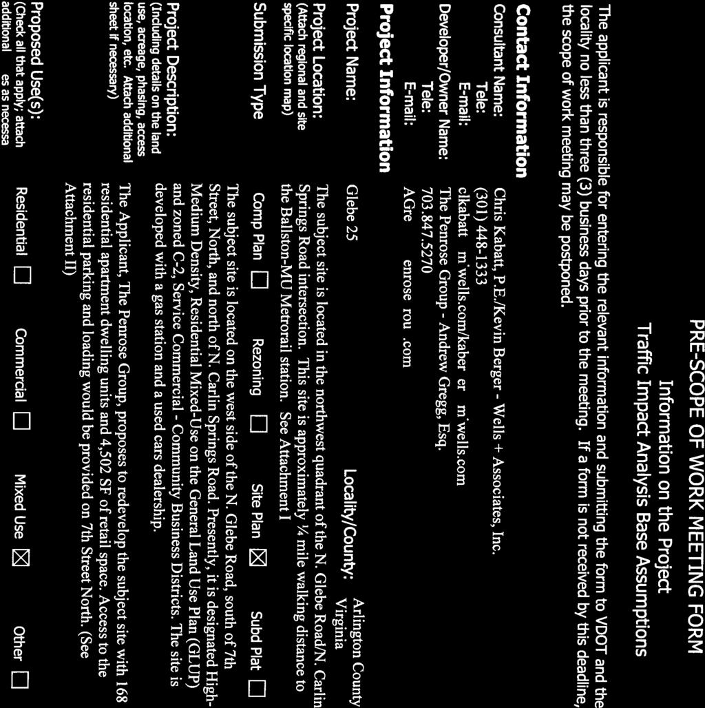
71 B-1
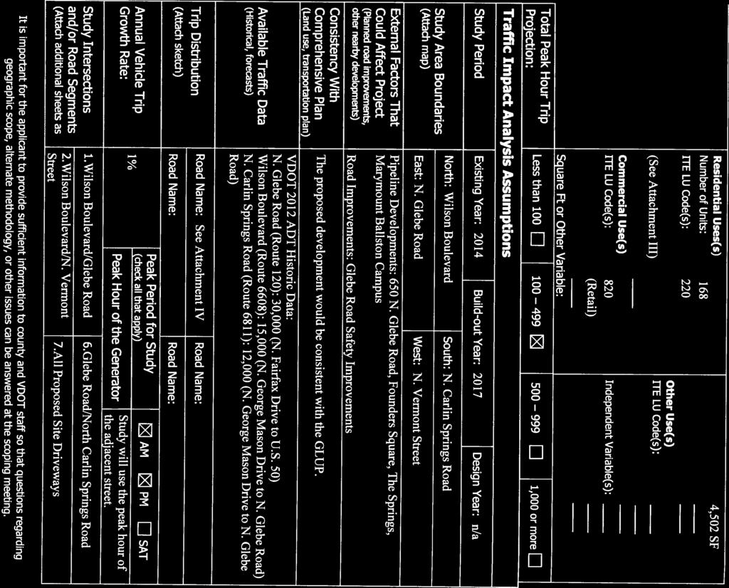
72 B-2
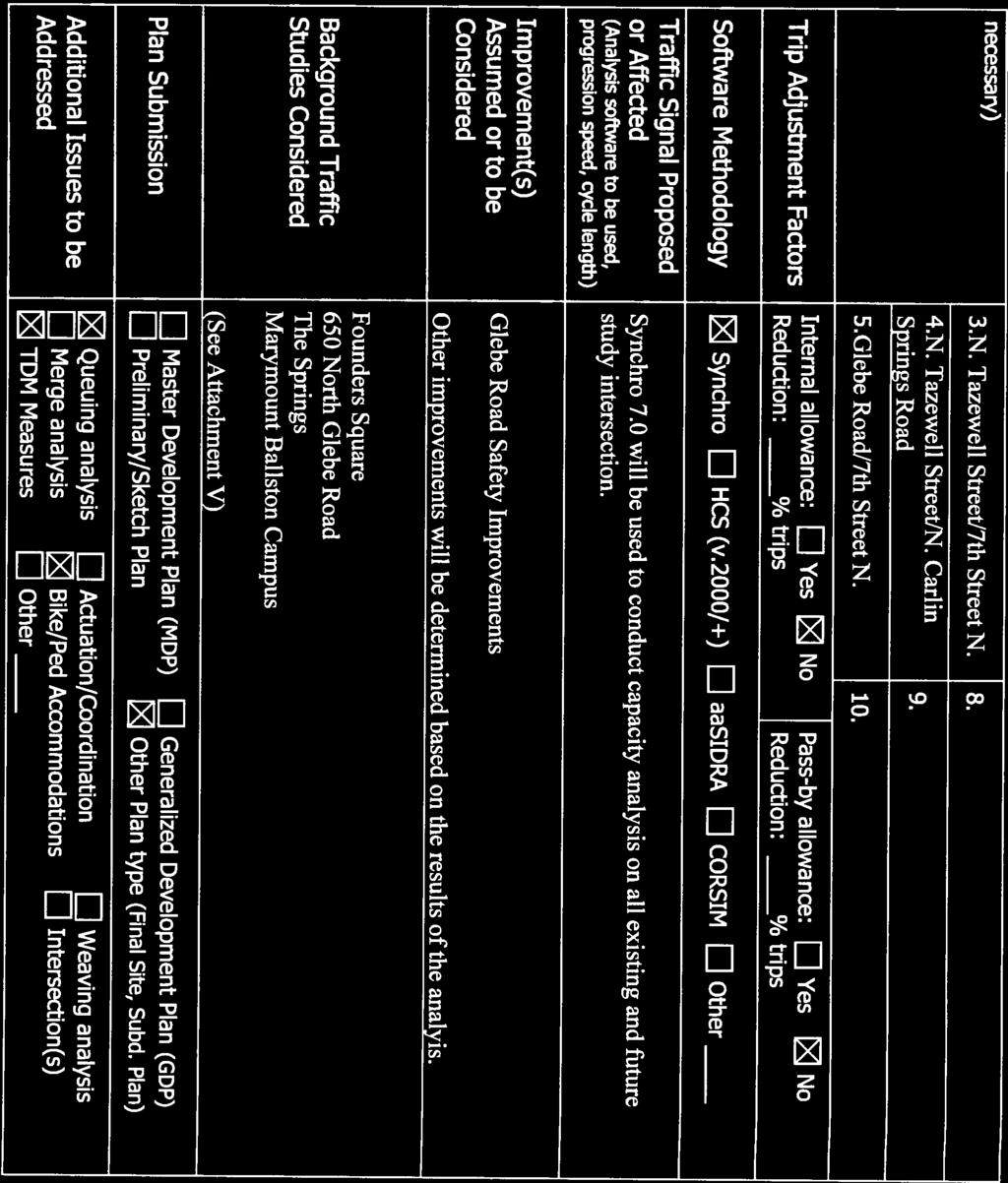
73 B-3
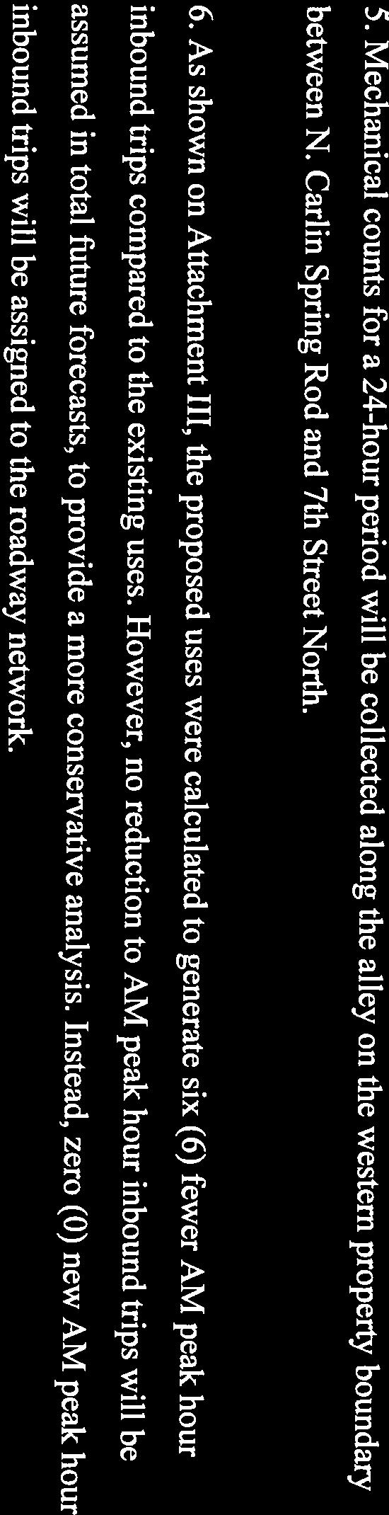
74 B-4


75 B-5
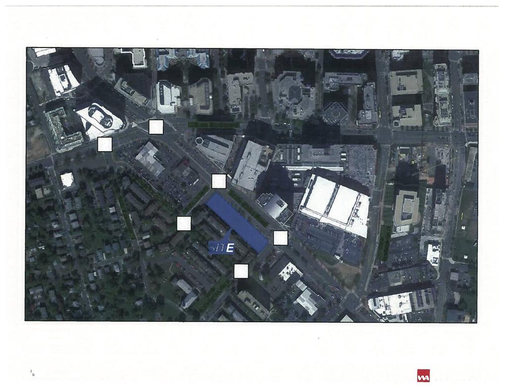
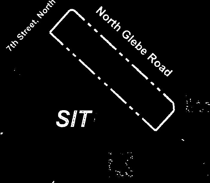
76 B-6
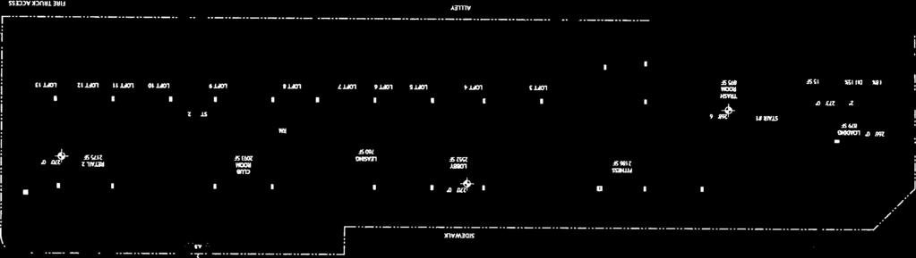
77 B-7
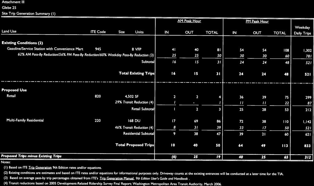
78 B-8
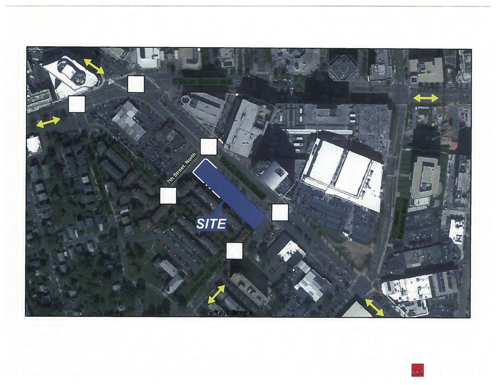
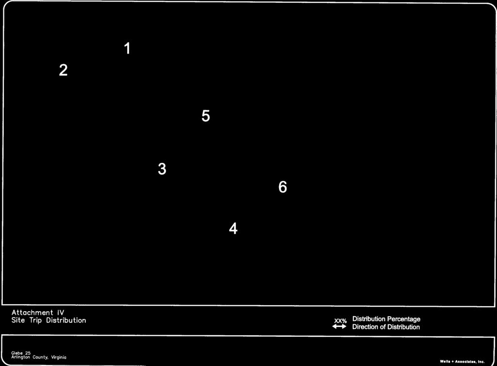


79 B-9
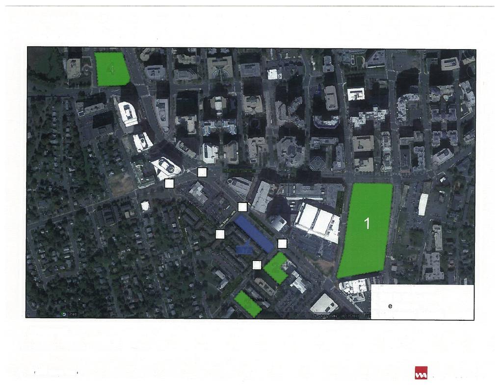
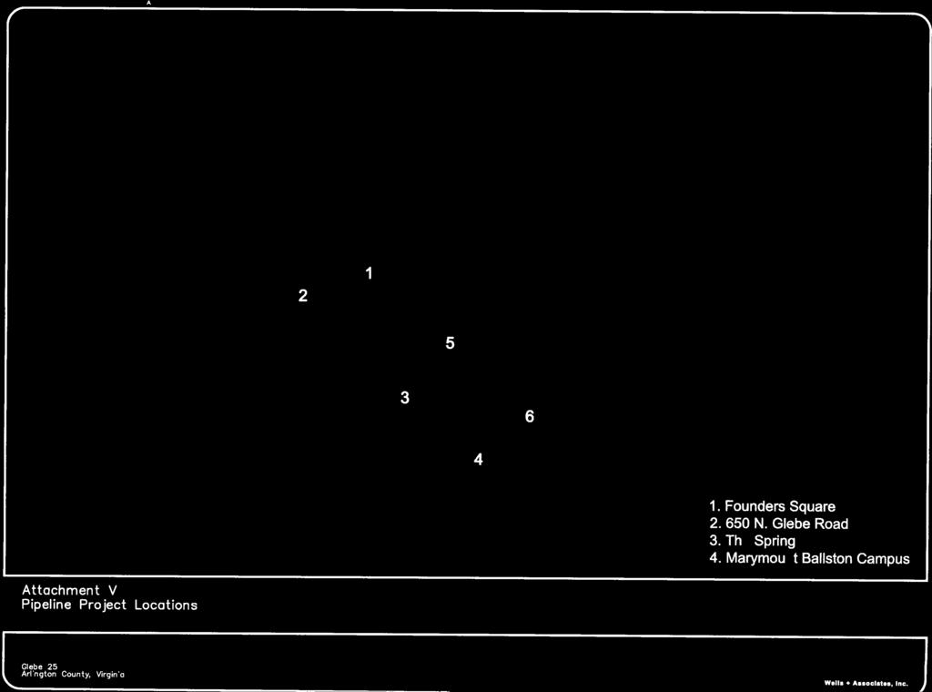
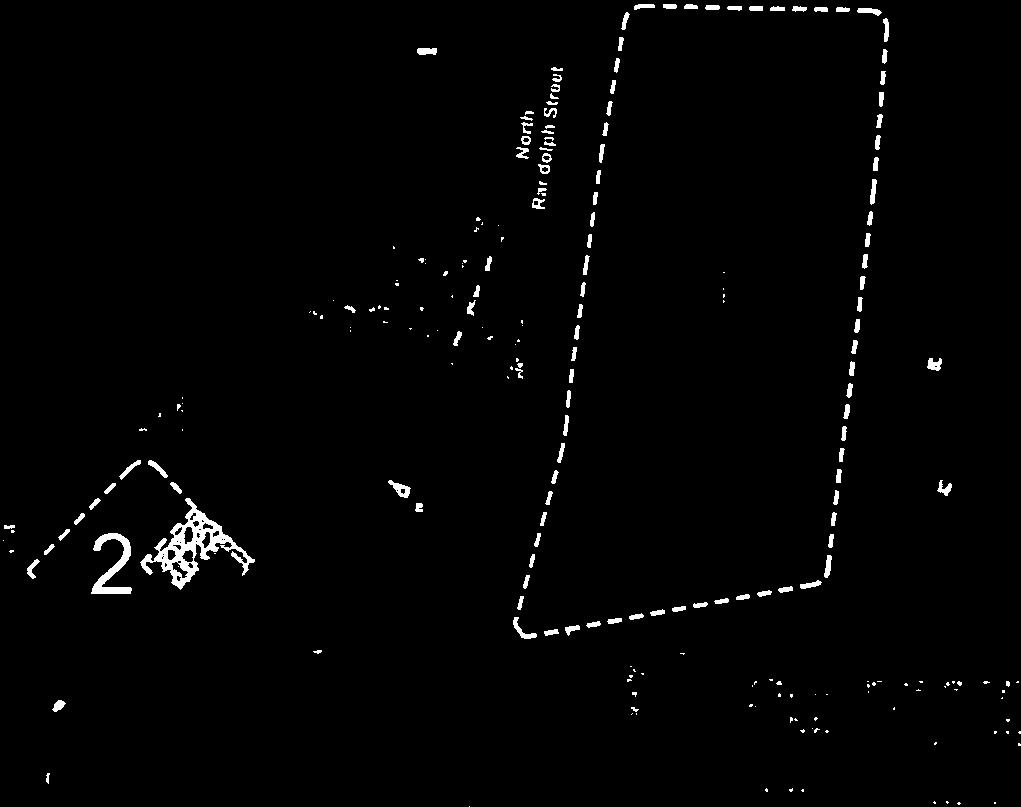
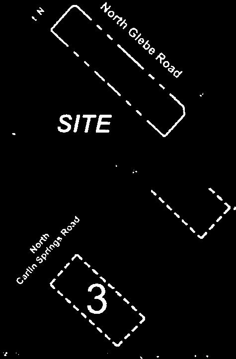


80 B-10
NVR AT BALLSTON TRAFFIC IMPACT ANALYSIS ARLINGTON COUNTY, VIRGINIA
 NVR AT BALLSTON TRAFFIC IMPACT ANALYSIS ARLINGTON COUNTY, VIRGINIA Prepared for: NVR, Incorporated Prepared by: Wells + Associates, Inc. Michael Workosky, PTP, TOPS, TSOS John Cavan, P.E., PTOE 703.917.6620
West Rosslyn Development
 Traffic Impact Study and Transportation Management Plan West Rosslyn Development Arlington County, VA Revised: January 11, 2017 May 10, 2016 Prepared for: Penzance 2400 N Street, NW, Suite 600 Washington,
MILLERSVILLE PARK TRAFFIC IMPACT ANALYSIS ANNE ARUNDEL COUNTY, MARYLAND
 MILLERSVILLE PARK TRAFFIC IMPACT ANALYSIS ANNE ARUNDEL COUNTY, MARYLAND Prepared for: Department of Public Works Anne Arundel County Prepared by: URS Corporation 4 North Park Drive, Suite 3 Hunt Valley,
Bennett Pit. Traffic Impact Study. J&T Consulting, Inc. Weld County, Colorado. March 3, 2017
 Bennett Pit Traffic Impact Study J&T Consulting, Inc. Weld County, Colorado March 3, 217 Prepared By: Sustainable Traffic Solutions, Inc. http://www.sustainabletrafficsolutions.com/ Joseph L. Henderson,
886 March Road McDonald's Transportation Study
 McDonald's Restaurants of Canada Limited March 2013 886 March Road McDonald's Transportation Study Submitted by: HDR Corporation 100 York Boulevard, Suite 300 Richmond Hill, ON L4B 1J8 (905) 882-4100 www.hdrinc.com
7359 WISCONSIN AVENUE MONTGOMERY COUNTY, MARYLAND
 7359 WISCONSIN MONTGOMERY COUNTY, MARYLAND September 1, 2017 7359 Wisconsin Avenue September 2017 7359 WISCONSIN Local Area Transportation Review Montgomery County, Maryland September 1, 2017 Prepared
LAWRENCE TRANSIT CENTER LOCATION ANALYSIS 9 TH STREET & ROCKLEDGE ROAD / 21 ST STREET & IOWA STREET LAWRENCE, KANSAS
 LAWRENCE TRANSIT CENTER LOCATION ANALYSIS 9 TH STREET & ROCKLEDGE ROAD / 21 ST STREET & IOWA STREET LAWRENCE, KANSAS TRAFFIC IMPACT STUDY FEBRUARY 214 OA Project No. 213-542 TABLE OF CONTENTS 1. INTRODUCTION...
L1TILE BEARS DAY CARE TRANSPORTATION IMPACT STUDY FORT COLLINS, COLORADO MAY Prepared for:
 L1TILE BEARS DAY CARE TRANSPORTATION IMPACT STUDY FORT COLLINS, COLORADO MAY 2012 Prepared for: Hillside Construction, Inc. 216 Hemlock Street, Suite B Fort Collins, CO 80534 Prepared by: DELICH ASSOCIATES
2.0 Development Driveways. Movin Out June 2017
 Movin Out June 2017 1.0 Introduction The proposed Movin Out development is a mixed use development in the northeast quadrant of the intersection of West Broadway and Fayette Avenue in the City of Madison.
Traffic Impact Study Speedway Gas Station Redevelopment
 Traffic Impact Study Speedway Gas Station Redevelopment Warrenville, Illinois Prepared For: Prepared By: April 11, 2018 Table of Contents 1. Introduction... 1 2. Existing Conditions... 4 Site Location...
Traffic Impact Analysis Update
 Willow Bend Traffic Impact Analysis Update TABLE OF CONTENTS Page I. INTRODUCTION -------------------------------------------------------------------------------------------- 1 II. EXISTING CONDITIONS
 Traffic Analysis For Approved Uses within the St. Lucie West DRI Aldi Port St. Lucie, FL Prepared for: Bohler Engineering, LLC 1000 Corporate Drive Suite 250 Fort Lauderdale, FL 33334 Prepared by: 10795
Lacey Gateway Residential Phase 1
 Lacey Gateway Residential Phase Transportation Impact Study April 23, 203 Prepared for: Gateway 850 LLC 5 Lake Bellevue Drive Suite 02 Bellevue, WA 98005 Prepared by: TENW Transportation Engineering West
Re: Residential Development - Ogilvie/Cummings Transportation Overview
 1223 Michael Street, Suite 100, Ottawa, ON K1J 7T2 Tel: 613.738.4160 Fax: 613.739.7105 www.delcan.com March 28, 2012 OUR REF: TO3088TOY Barry J. Hobin & Architects 63 Pamilla Street Ottawa, ON K1S 3K7
INTERSECTION ANALYSIS PARK AVENUE AND BRADDOCK ROAD (FROSTBURG, MD) FOR LENHART TRAFFIC CONSULTING, INC.
 FOR LENHART TRAFFIC CONSULTING, INC.") INTERSECTION ANALYSIS FOR PARK AVENUE AND BRADDOCK ROAD (FROSTBURG, MD) Prepared for: City of Frostburg, Maryland & Allegany County Commissioners Prepared by: LENHART TRAFFIC CONSULTING, INC. TRAFFIC ENGINEERING
INTERSECTION ANALYSIS FOR PARK AVENUE AND BRADDOCK ROAD (FROSTBURG, MD) Prepared for: City of Frostburg, Maryland & Allegany County Commissioners Prepared by: LENHART TRAFFIC CONSULTING, INC. TRAFFIC ENGINEERING
Table 1 - Land Use Comparisons - Proposed King s Wharf Development. Retail (SF) Office (SF) 354 6,000 10, Land Uses 1
 Office (SF) 354 6,000 10, Land Uses 1") Ref. No. 171-6694 Phase 2 November 23, 217 Mr. David Quilichini, Vice President Fares & Co. Developments Inc. 31 Place Keelson Sales Centre DARTMOUTH NS B2Y C1 Sent Via Email to David@faresinc.com RE:
Ref. No. 171-6694 Phase 2 November 23, 217 Mr. David Quilichini, Vice President Fares & Co. Developments Inc. 31 Place Keelson Sales Centre DARTMOUTH NS B2Y C1 Sent Via Email to David@faresinc.com RE:
Proposed Hotel and Restaurant Development
 Traffic Impact Study Proposed Hotel and Restaurant Development Marbledale Road Tuckahoe, NY PREPARED FOR BILLWIN DEVELOPMENT AFFILIATES, LLC 365 WHITE PLAINS ROAD EASTCHESTER, NY. 10709 PREPARED BY Engineering
APPENDIX C1 TRAFFIC ANALYSIS DESIGN YEAR TRAFFIC ANALYSIS
 APPENDIX C1 TRAFFIC ANALYSIS DESIGN YEAR TRAFFIC ANALYSIS DESIGN YEAR TRAFFIC ANALYSIS February 2018 Highway & Bridge Project PIN 6754.12 Route 13 Connector Road Chemung County February 2018 Appendix
Craig Scheffler, P.E., PTOE HNTB North Carolina, P.C. HNTB Project File: Subject
 TECHNICAL MEMORANDUM To Kumar Neppalli Traffic Engineering Manager Town of Chapel Hill From Craig Scheffler, P.E., PTOE HNTB North Carolina, P.C. Cc HNTB Project File: 38435 Subject Obey Creek TIS 2022
Prepared For: Toronto Transit Commission 1138 Bathurst Street Toronto, Ontario M5R 3H2. Prepared By:
 TRAFFIC IMPACT STUDY FOR THE TTC MCNICOLL BUS GARAGE CITY OF TORONTO Prepared For: Toronto Transit Commission 1138 Bathurst Street Toronto, Ontario M5R 3H2 Prepared By: Canada Inc. 4th Floor, 3 Leek Crescent
DEVELOPMENT PROPERTY 1627 MAXIME STREET CITY OF OTTAWA TRANSPORTATION OVERVIEW. Prepared for: Subhas Bhargava. July 9, Overview_1.
 DEVELOPMENT PROPERTY 1627 MAXIME STREET CITY OF OTTAWA TRANSPORTATION OVERVIEW Prepared for: Subhas Bhargava July 9, 2015 115-620 Overview_1.doc D. J. Halpenny & Associates Ltd. Consulting Transportation
King Soopers #116 Thornton, Colorado
 Traffic Impact Study King Soopers #116 Thornton, Colorado Prepared for: Galloway & Company, Inc. T R A F F I C I M P A C T S T U D Y King Soopers #116 Thornton, Colorado Prepared for Galloway & Company
One Harbor Point Residential
 Residential Gig Harbor, WA Transportation Impact Analysis January 23, 2017 Prepared for: Neil Walter Company PO Box 2181 Tacoma, WA 98401 Prepared by: TENW Transportation Engineering NorthWest 11400 SE
Oakbrook Village Plaza City of Laguna Hills
 Oakbrook Village Plaza City of Laguna Hills Traffic Impact Analysis Prepared by: HDR Engineering 3230 El Camino Real, Suite 200 Irvine, CA 92602 October 2012 Revision 3 D-1 Oakbrook Village Plaza Laguna
4131 Chain Bridge Road
 Traffic Impact Study 4131 Chain Bridge Road City of Fairfax, VA 05/04/16 May 4, 2016 Prepared for: Paradigm 1415 North Taft Street Suite 100 Arlington, VA 22201 This report is printed on environmentally
EXECUTIVE SUMMARY. The following is an outline of the traffic analysis performed by Hales Engineering for the traffic conditions of this project.
 EXECUTIVE SUMMARY This study addresses the traffic impacts associated with the proposed Shopko redevelopment located in Sugarhouse, Utah. The Shopko redevelopment project is located between 1300 East and
Provide an overview of the development proposal including projected site traffic volumes;
 December 19, 2013 File: 163600935 Attention: Troy Elliott Carl Elliott Limited 15-1831 Robertson Road PO Box 11117 Nepean, Ontario K1H 7T8 Dear Mr. Elliott, Reference: 2235 and 2265 Robertson Road Transportation
Appendix B. Tier 2 Final Environmental Assessment I-66 Transit/TDM Technical Report
 Tier 2 Final Environmental Assessment I-66 Transit/TDM Technical Report Appendix B Bus Bay, Maintenance, and Storage Capacity Analysis Technical Memorandum FINAL MAY 2016 INTRODUCTION This technical memorandum
Traffic Impact Analysis Farmington Center Village
 Traffic Impact Analysis Farmington Center Village Route 4 (Farmington Avenue) Farmington, Connecticut Prepared for: The Town of Farmington, CT Prepared By: BL Companies Meriden, Connecticut December 2016
GASOLINE SERVICE STATION 1618, 1622 ROGER STEVENS DRIVE OTTAWA, ONTARIO TRANSPORTATION IMPACT ASSESSMENT. Prepared for:
 GASOLINE SERVICE STATION 1618, 1622 ROGER STEVENS DRIVE OTTAWA, ONTARIO TRANSPORTATION IMPACT ASSESSMENT Prepared for: Invecta Development (Ottawa) Corporation 758 Shanks Height Milton, ON L9T 7P7 May
Appendix C-5: Proposed Refinements Rail Operations and Maintenance Facility (ROMF) Traffic Impact Analysis. Durham-Orange Light Rail Transit Project
 Traffic Impact Analysis. Durham-Orange Light Rail Transit Project") Appendix C-5: Proposed Refinements Rail Operations and Maintenance Facility (ROMF) Traffic Impact Analysis Durham-Orange Light Rail Transit Project July 25, 218 ROMF Transportation Impact Analysis Version
Appendix C-5: Proposed Refinements Rail Operations and Maintenance Facility (ROMF) Traffic Impact Analysis Durham-Orange Light Rail Transit Project July 25, 218 ROMF Transportation Impact Analysis Version
Transportation & Traffic Engineering
 Transportation & Traffic Engineering 1) Project Description This report presents a summary of findings for a Traffic Impact Analysis (TIA) performed by A+ Engineering, Inc. for the Hill Country Family
Ingraham High School Parking and Traffic Analysis
 Parking and Traffic Analysis Seattle, WA Prepared for: URS Corporation 1501 4th Avenue, Suite 1400 Seattle, WA 98101-1616 Mirai Transportation Planning & Engineering 11410 NE 122nd Way, Suite 320 Kirkland,
TRAFFIC SIGNAL DESIGN REPORT KING OF PRUSSIA ROAD & RAIDER ROAD RADNOR TOWNSHIP PENNSYLVANIA
 TRAFFIC SIGNAL DESIGN REPORT KING OF PRUSSIA ROAD & RAIDER ROAD RADNOR TOWNSHIP PENNSYLVANIA PREPARED FOR: UNIVERSITY OF PENNSYLVANIA HEALTH SYSTEM 34 CIVIC CENTER BOULEVARD PHILADELPHIA, PA 1987 (61)
LOST LAKE CORRIDOR REVIEW
 LOST LAKE CORRIDOR REVIEW Prepared for: Prepared by: Broadview Developments Inc. c/o Westbrook Consulting Watt Consulting Group Our File: 2064.B01 Date: October 31, 2016 TABLE OF CONTENTS 1.0 INTRODUCTION...
VIRGINIA HOSPITAL CENTER MULTIMODAL TRAFFIC IMPACT ANALYSIS ARLINGTON COUNTY, VIRGINIA TABLE OF CONTENTS
 VIRGINIA HOSPITAL CENTER MULTIMODAL TRAFFIC IMPACT ANALYSIS ARLINGTON COUNTY, VIRGINIA TABLE OF CONTENTS Section INTRODUCTION Introduction... Study Scope... 2 Section 2 BACKGROUND INFORMATION Existing
INDUSTRIAL DEVELOPMENT
 INDUSTRIAL DEVELOPMENT Traffic Impact Study Plainfield, Illinois August 2018 Prepared for: Seefried Industrial Properties, Inc. TABLE OF CONTENTS Executive Summary 2 Introduction 3 Existing Conditions
Re: Cyrville Road Car Dealership
 1223 Michael Street, Suite 100, Ottawa, ON K1J 7T2 Tel: 613.738.4160 Fax: 613.739.7105 www.delcan.com February 25, 2013 OUR REF: TO3098TOE Mark Motors of Ottawa 611 Montreal Road Ottawa, ON K1K 0T8 Attention:
Vanier Parkway and Presland Road Residential Development Transportation Impact Study
 Vanier Parkway and Presland Road Residential Development Transportation Impact Study Final Report (Revised) March 2011 Submitted to: Groupe Lépine Ottawa Project No. 09-1613 Submitted by: Groupe Lépine
MEMO VIA . Ms. Amy Roth DPS Director, City of Three Rivers. To:
 MEMO To: Ms. Amy Roth DPS Director, City of Three Rivers VIA EMAIL From: Michael J. Labadie, PE Julie M. Kroll, PE, PTOE Brandon Hayes, PE, P.Eng. Fleis & VandenBrink Date: January 5, 2017 Re: Proposed
Traffic Impact Statement (TIS)
") Traffic Impact Statement (TIS) Vincentian PUDA Collier County, FL 10/18/2013 Prepared for: Global Properties of Naples Prepared by: Trebilcock Consulting Solutions, PA 2614 Tamiami Trail N, Suite 615 1205
Traffic Impact Statement (TIS) Vincentian PUDA Collier County, FL 10/18/2013 Prepared for: Global Properties of Naples Prepared by: Trebilcock Consulting Solutions, PA 2614 Tamiami Trail N, Suite 615 1205
RICHMOND OAKS HEALTH CENTRE 6265 PERTH STREET OTTAWA, ONTARIO TRANSPORTATION BRIEF. Prepared for: Guycoki (Eastern) Limited.
 Limited.") RICHMOND OAKS HEALTH CENTRE 6265 PERTH STREET OTTAWA, ONTARIO TRANSPORTATION BRIEF Prepared for: Guycoki (Eastern) Limited June 16, 2016 116-638 Brief_1.doc D. J. Halpenny & Associates Ltd. Consulting
RICHMOND OAKS HEALTH CENTRE 6265 PERTH STREET OTTAWA, ONTARIO TRANSPORTATION BRIEF Prepared for: Guycoki (Eastern) Limited June 16, 2016 116-638 Brief_1.doc D. J. Halpenny & Associates Ltd. Consulting
Proposed location of Camp Parkway Commerce Center. Vicinity map of Camp Parkway Commerce Center Southampton County, VA
 Proposed location of Camp Parkway Commerce Center Vicinity map of Camp Parkway Commerce Center Southampton County, VA Camp Parkway Commerce Center is a proposed distribution and industrial center to be
RTE. 1 at RTE. 637 & RTE. 639
 INTERSECTION SAFETY STUDY Prepared for: Virginia Department of Transportation Central Region Operations Traffic Engineering (UPC #81378, TO 12-092) DAVENPORT Project Number: 13-368 / /2014 RTE. 1 at RTE.
TRAFFIC IMPACT ANALYSIS
 TRAFFIC IMPACT ANALYSIS Emerald Isle Commercial Development Prepared by SEPI Engineering & Construction Prepared for Ark Consulting Group, PLLC March 2016 I. Executive Summary A. Site Location The Emerald
Proposed Office Building Traffic Impact Study Chicago Avenue Evanston, Illinois
 Proposed Office Building Traffic Impact Study 1714-1720 Chicago Avenue Evanston, Illinois Prepared For: HOLABIRD & ROOT, LLC Prepared by: Eriksson Engineering Associates, Ltd. 145 Commerce Drive, Ste A,
Traffic Feasibility Study
 Traffic Feasibility Study Town Center South Robbinsville Township, Mercer County, New Jersey December 19, 2017 Prepared For Robbinsville Township Department of Community Development 2298 Route 33 Robbinsville,
LCPS Valley Service Center
 Traffic Impact Study LCPS Valley Service Center Loudoun County, Virginia November 4, 2015 Prepared For: Loudoun County Public Schools 21000 Education Court Ashburn, VA 20148 Prepared by: 1140 Connecticut
Escondido Marriott Hotel and Mixed-Use Condominium Project TRAFFIC IMPACT ANALYSIS REPORT
 Escondido Marriott Hotel and Mixed-Use Condominium Project TRAFFIC IMPACT ANALYSIS REPORT Prepared for Phelps Program Management 420 Sixth Avenue, Greeley, CO 80632 Prepared by 5050 Avenida Encinas, Suite
Paisley & Whitelaw - Paisley Park OPA / ZBA for Mixed Density Residential Use
 Paisley & Whitelaw - Paisley Park OPA / ZBA for Mixed Density Residential Use Transportation Impact Study City of Guelph Prepared for: Armel Corporation August 2018 Table of Contents 1 Introduction...
Alpine Highway to North County Boulevard Connector Study
 Alpine Highway to North County Boulevard Connector Study prepared by Avenue Consultants March 16, 2017 North County Boulevard Connector Study March 16, 2017 Table of Contents 1 Summary of Findings... 1
April Salvation Army Barrhaven Church 102 Bill Leathem Drive Transportation Brief
 April 26 Salvation Army Barrhaven Church 2 Bill Leathem Drive Transportation Brief Salvation Army Barrhaven Church 2 Bill Leathem Drive Transportation Brief prepared for: The Salvation Army 2 Overlea Blvd.
Downtown One Way Street Conversion Technical Feasibility Report
 Downtown One Way Street Conversion Technical Feasibility Report As part of the City s Transportation Master Plan, this report reviews the technical feasibility of the proposed conversion of the current
Traffic Impact Study for Proposed Olive Boulevard Development
 Traffic Impact Study for Proposed 11330 Olive Boulevard Development Creve Coeur, Missouri July 7, 2017 Prepared For: 11330 Olive Boulevard Development 11330 Olive Boulevard Creve Coeur, Missouri 63141
Traffic Impact Study Proposed Residential Development (Watson Parkway North - Starwood Drive Node, City of Guelph)
") Traffic Impact Study Proposed Residential Development (Watson Parkway North - Starwood Drive Node, City of Guelph) Prepared By: 332 Lorne Avenue East Stratford ON N5A 6S4 Prepared for: Paul Kemper, President
Traffic Impact Study Proposed Residential Development (Watson Parkway North - Starwood Drive Node, City of Guelph) Prepared By: 332 Lorne Avenue East Stratford ON N5A 6S4 Prepared for: Paul Kemper, President
Traffic Engineering Study
 Traffic Engineering Study Bellaire Boulevard Prepared For: International Management District Technical Services, Inc. Texas Registered Engineering Firm F-3580 November 2009 Executive Summary has been requested
BARRHAVEN FELLOWSHIP CRC 3058 JOCKVALE ROAD OTTAWA, ONTARIO TRANSPORTATION BRIEF. Prepared for:
 BARRHAVEN FELLOWSHIP CRC 3058 JOCKVALE ROAD OTTAWA, ONTARIO TRANSPORTATION BRIEF Prepared for: Barrhaven Fellowship CRC 3058 Jockvale Road Ottawa, ON K2J 2W7 December 7, 2016 116-649 Report_1.doc D. J.
TIMBERVINE TRANSPORTATION IMPACT STUDY FORT COLLINS, COLORADO JANUARY Prepared for:
 TIMBERVINE TRANSPORTATION IMPACT STUDY FORT COLLINS, COLORADO JANUARY 2014 Prepared for: Hartford Companies 1218 W. Ash Street Suite A Windsor, Co 80550 Prepared by: DELICH ASSOCIATES 2272 Glen Haven Drive
THE CORNERSTONE APARTMENTS TRAFFIC IMPACT STUDY R&M PROJECT NO
 THE CORNERSTONE APARTMENTS SITUATED AT N/E/C OF STAUDERMAN AVENUE AND FOREST AVENUE VILLAGE OF LYNBROOK NASSAU COUNTY, NEW YORK TRAFFIC IMPACT STUDY R&M PROJECT NO. 2018-089 September 2018 50 Elm Street,
King County Metro. Columbia Street Transit Priority Improvements Alternative Analysis. Downtown Southend Transit Study. May 2014.
 King County Metro Columbia Street Transit Priority Improvements Alternative Analysis Downtown Southend Transit Study May 2014 Parametrix Table of Contents Introduction... 1 Methodology... 1 Study Area...
Bi-County Transitway/ Bethesda Station Access Demand Analysis
 Bi-County Transitway/ Bethesda Station Access Demand Analysis Prepared for: Washington Metropolitan Area Transit Authority Office of Planning and Project Development May 2005 Prepared by: in conjunction
TRAFFIC IMPACT STUDY FOR SONIC DRIVE-IN RESTAURANT. Vallejo, CA. Prepared For:
 TRAFFIC IMPACT STUDY FOR SONIC DRIVE-IN RESTAURANT Vallejo, CA Prepared For: ELITE DRIVE-INS, INC. 2190 Meridian Park Blvd, Suite G Concord, CA 94520 Prepared By: KD Anderson & Associates 3853 Taylor Road,
Quantitative analyses of weekday a.m. and p.m. commuter hour conditions have been conducted for the following five scenarios:
 6.1 TRANSPORTATION AND CIRCULATION 6.1.1 INTRODUCTION This section of the EIR presents the results of TJKM s traffic impact analysis of the proposed Greenbriar Development. The analysis includes consideration
COMPREHENSIVE TRANSPORTATION REVIEW SHEPHERD PARK PUD WASHINGTON, DC
 COMPREHENSIVE TRANSPORTATION REVIEW SHEPHERD PARK PUD WASHINGTON, DC May 31, 2016 Prepared by: 1140 Connecticut Avenue NW Suite 600 Washington, DC 20036 Tel: 202.296.8625 Fax: 202.785.1276 3914 Centreville
Clean Harbors Canada, Inc.
 Clean Harbors Canada, Inc. Proposed Lambton Landfill Expansion Environmental Assessment Terms of Reference Transportation Assessment St. Clair Township, Ontario September 2009 itrans Consulting Inc. 260
Parking/Traffic Assessment Study
 Brock Road Industrial Mall 985 Brock Road South City of Pickering Parking/Traffic Assessment Study Prepared by: Tranplan Associates, Toronto Toronto 416-670-2005 Sudbury 705-522-0272 Peterborough 705-874-3638
D & B COMMERCIAL TRAFFIC IMPACT ANALYSIS
 D & B COMMERCIAL TRAFFIC IMPACT ANALYSIS TABLE OF CONTENTS I. Introduction...3 II. Project Description...3 III. Existing Conditions...3 IV. Future Traffic Conditions...8 V. Conclusions and Mitigation...14
Proposed Inn at Bellefield Traffic Impact Assessment
 Proposed Inn at Bellefield Traffic Impact Assessment Town of Hyde Park Dutchess County, New York Prepared for: T-Rex Hyde Park Owner LLC 500 Mamroneck Avenue, Suite 300 Harrison, NY 10528 June 21, 2017
MERIVALE PRIORITY SQUARE 2852 MERIVALE ROAD CITY OF OTTAWA TRANSPORTATION BRIEF. Prepared for: ONT Inc. 25 Winding Way Nepean, Ontario K2C 3H1
 MERIVALE PRIORITY SQUARE 2852 MERIVALE ROAD CITY OF OTTAWA TRANSPORTATION BRIEF Prepared for: 2190986ONT Inc. 25 Winding Way Nepean, Ontario K2C 3H1 October 6, 2010 110-502 Report_1.doc D. J. Halpenny
RESPONSE TO TRAFFIC IMPACT STUDY COMMENTS
 RESPONSE TO TRAFFIC IMPACT STUDY COMMENTS Proposed Gas Station 40 Arthur Street (Highway 26), Town of the Blue Mountains (Thornbury), County of Grey, Ontario AUGUST 2013 August 27, 2013 MR. REG RUSSWURM
Traffic Impact Analysis. Alliance Cole Avenue Residential Site Dallas, Texas. Kimley-Horn and Associates, Inc. Dallas, Texas.
 Traffic Impact Analysis Alliance Cole Avenue Residential Site Dallas, Texas February 15, 2018 Kimley-Horn and Associates, Inc. Dallas, Texas Project #064524900 Registered Firm F-928 Traffic Impact Analysis
Barrhaven Honda Dealership. Dealership Drive, Ottawa, ON. Transportation Brief
 Barrhaven Honda Dealership Dealership Drive, Ottawa, ON Transportation Brief Prepared By: NOVATECH Suite 200, 240 Michael Cowpland Drive Ottawa, Ontario K2M 1P6 September, 2015 File: 115136 Ref: R-2015-152
County State Aid Highway 30 (Diffley Road) and Dodd Road Intersection Study
 and Dodd Road Intersection Study") County State Aid Highway 30 (Diffley Road) and Dodd Road Intersection Study City of Eagan, Dakota County, Minnesota Date: March 2012 Project No. 14957.000 444 Cedar Street, Suite 1500 Saint Paul, MN 55101
County State Aid Highway 30 (Diffley Road) and Dodd Road Intersection Study City of Eagan, Dakota County, Minnesota Date: March 2012 Project No. 14957.000 444 Cedar Street, Suite 1500 Saint Paul, MN 55101
Lakeside Terrace Development
 Lakeside Terrace Development City of Barrie, County of Simcoe Traffic Brief for: Type of Document: Final Report Project Number: JDE 1617 Date Submitted: April 29 th, 216 4/29/16 John Northcote, P.Eng.
TRAFFIC IMPACT ANALYSIS SHORTBREAD LOFTS 2009 MODIFICATION Chapel Hill, North Carolina
 TRAFFIC IMPACT ANALYSIS SHORTBREAD LOFTS 2009 MODIFICATION Chapel Hill, North Carolina Prepared for: The Town of Chapel Hill, NC Prepared by: Architects-Engineers-Planners, Inc. November 2009 Traffic Impact
830 Main Street Halifax Regional Municipality
 830 Main Street Halifax Regional Municipality Traffic Impact Statement Final Report Prepared by: GRIFFIN transportation group inc. 30 Bonny View Drive Fall River, NS B2T 1R2 www.griffininc.ca Prepared
Wellings Communities Holding Inc and Extendicare (Canada) Inc Hazeldean Road. Transportation Impact Study. Ottawa, Ontario. Project ID
 Inc Hazeldean Road. Transportation Impact Study. Ottawa, Ontario. Project ID") Wellings Communities Holding Inc and Extendicare (Canada) Inc. 5731 Hazeldean Road Transportation Impact Study Ottawa, Ontario Project ID 160401195 Prepared by: Stantec Consulting Ltd. March 2016 WELLINGS
Wellings Communities Holding Inc and Extendicare (Canada) Inc. 5731 Hazeldean Road Transportation Impact Study Ottawa, Ontario Project ID 160401195 Prepared by: Stantec Consulting Ltd. March 2016 WELLINGS
West Hills Shopping Centre Lowe s Expansion Traffic Impact Study
 West Hills Shopping Centre Lowe s Expansion Traffic Impact Study Prepared for: Armel Corporation January 2015 Paradigm Transportation Solutions Ltd. 22 King Street South, Suite 300 Waterloo ON N2J 1N8
Weaver Road Senior Housing Traffic Impact Analysis
 Gibson Traffic Consultants, Inc. 2813 Rockefeller Avenue Suite B Everett, WA 9821 425.339.8266 Weaver Road Senior Housing Traffic Impact Analysis Jurisdiction: City of Snohomish January 218 GTC #17-37
Traffic Impact Analysis 5742 BEACH BOULEVARD MIXED USE PROJECT
 Traffic Impact Analysis 5742 BEACH BOULEVARD MIXED USE PROJECT CITY OF BUENA PARK Prepared by Project No. 14139 000 April 17 th, 2015 DKS Associates Jeffrey Heald, P.E. Rohit Itadkar, T.E. 2677 North Main
Traffic Impact Study. Eastern Springs. A Proposed Development in Manorville, NY. April Haas Group Inc Transportation Planners and Engineers
 Traffic Impact Study For Eastern Springs A Proposed Development in Manorville, NY April 2018 Haas Group Inc Transportation Planners and Engineers Table of Contents 1) Executive Summary... 2 2) Study Purpose...
Traffic Impact Study Hudson Street Parking Garage MC Project No.: A Table of Contents
 Traffic Impact Study Hudson Street Parking Garage MC Project No.: 15001714A Table of Contents Table of Contents I. INTRODUCTION... 1 II. EXISTING CONDITIONS... 4 III. 2015 EXISTING TRAFFIC CONDITIONS...
TRANSPORTATION MASTER PLAN AND TRANSPORTATION IMPACT ASSESSMENT FOR THREE SISTERS MOUNTAIN VILLAGE RESORT CENTRE ASP
 TRANSPORTATION MASTER PLAN AND TRANSPORTATION IMPACT ASSESSMENT FOR THREE SISTERS MOUNTAIN VILLAGE RESORT CENTRE ASP OCTOBER 2016 STANDARD LIMITATIONS This report was prepared by MMM Group Limited, a WSP
Traffic Impact Study Proposed Commercial Development Ballwin, Missouri. Technical Memorandum for Traffic Impact Study
 Traffic Impact Study Proposed Commercial Development Ballwin, Missouri Technical Memorandum for Traffic Impact Study Crawford, Bunte, Brammeier May 1, 2009 MEMORANDUM Date: April 24, 2009 To: From: Subject:
STANDARD LIMITATIONS
 STANDARD LIMITATIONS This report was prepared by MMM Group (MMM) for the account of Spire Construction Inc. (the Client). The disclosure of any information contained in this report is the sole responsibility
Dulles Corridor Air Rights Study Investigation
 Dulles Corridor Air Rights Study Investigation Fairfax County Board of Supervisors Transportation Committee September 17, 2013 1 On March 19, 2013 the Fairfax County Board of Supervisors asked FCDOT staff
Traffic Impact Analysis West Street Garden Plots Improvements and DuPage River Park Garden Plots Development Naperville, Illinois
 Traffic Impact Analysis West Street Garden Plots Improvements and DuPage River Park Garden Plots Development Naperville, Illinois Submitted by April 9, 2009 Introduction Kenig, Lindgren, O Hara, Aboona,
TRAFFIC AND TRANSPORTATION TECHNICAL MEMORANDUM
 TRAFFIC AND TRANSPORTATION TECHNICAL MEMORANDUM for ENVIRONMENTAL ASSESSMENT US 460 Bypass Interchange and Southgate Drive Relocation State Project No.: 0460-150-204, P101, R201, C501, B601; UPC 99425
ARVADA TRIANGLE REDEVELOPMENT TRAFFIC IMPACT ANALYSIS
 ARVADA TRIANGLE REDEVELOPMENT TRAFFIC IMPACT ANALYSIS Prepared for: Arvada Urban Renewal Authority 5601 Olde Wadsworth Boulevard, Suite 210 Arvada, Colorado 80002 (720) 898-7062 Prepared by: Felsburg Holt
Winnetka Avenue Bike Lanes Traffic Impact Analysis
 Winnetka Avenue Bike Lanes Traffic Impact Analysis January 4, 2019 Prepared by City of Los Angeles Department of Transportation Active Transportation Division Winnetka Ave Bike Lanes Traffic Impact Analysis
APPENDIX E. Traffic Analysis Report
 APPENDIX E Traffic Analysis Report THIS PAGE INTENTIONALLY BLANK EAGLE RIVER TRAFFIC MITIGATION PHASE I OLD GLENN HIGHWAY/EAGLE RIVER ROAD INTERSECTION IMPROVEMENTS TRAFFIC ANALYSIS Eagle River, Alaska
MEMO. McCORMICK RANKIN CORPORATION. File Mark VanderSluis, Keyur Shah DATE: October 26, 2009 COPIES: OUR FILE: TO: FROM: Jack Thompson
 McCORMICK RANKIN CORPORATION 2655 North Sheridan Way Mississauga, Ontario, L5K 2P8 Tel: (95)823-85 Fax: (95) 823-853 E-mail: mrc@mrc.ca Website: www.mrc.ca MEMO TO: FROM: File Mark VanderSluis, Keyur Shah
MEMORANDUM. Date: November 4, Cheryl Burrell, Pebble Beach Company. Rob Rees, P.E. Inclusionary Housing Transportation Analysis WC
 MEMORANDUM Date: November 4, 2013 To: From: Subject: Cheryl Burrell, Pebble Beach Company Rob Rees, P.E. Inclusionary Housing Transportation Analysis As requested, Fehr & Peers is providing clarification
Reston Transportation Strategy July 9, 2018
 Reston Transportation Strategy July 9, 2018 Background: On February 11, 2014, the Board of Supervisors adopted the Reston Phase I Comprehensive Plan Amendment for the core areas of Reston between Sunset
Construction Staging Area 4 Avenue Road
 REPORT FOR ACTION Construction Staging Area 4 Avenue Road Date: September 27, 2017 To: Toronto and East York Community Council From: Acting Director, Transportation Services, Toronto and East York District
RE: A Traffic Impact Statement for a proposed development on Quinpool Road
 James J. Copeland, P.Eng. GRIFFIN transportation group inc. 30 Bonny View Drive Fall River, NS B2T 1R2 May 31, 2018 Ellen O Hara, P.Eng. Project Engineer DesignPoint Engineering & Surveying Ltd. 200 Waterfront
Project Advisory Committee
 Meredith US 3/NH 25 Improvements Transportation Planning Study Project Advisory Committee March 18, 2008 Meredith US 3/NH 25 Improvements Transportation Planning Study Meeting Agenda Welcome Traffic Model
Proposed CVS/pharmacy
 Traffic Impact and Access Study Proposed CVS/pharmacy West Main Street (Route 1) at Hull Street Clinton, Connecticut PREPARED FOR Arista Development LLC 520 Providence Highway, Suite 9 Norwood, Massachusetts
PROJECT: Wilkinson Road Corridor Improvement Traffic Management Planning Project SUBJECT: Traffic Analysis
 TECHNICAL MEMORANDUM DATE: September 10, 2014 PROJECT 5861.03 NO: PROJECT: Wilkinson Road Corridor Improvement Traffic Management Planning Project SUBJECT: Traffic Analysis TO: Steve Holroyd - District
TRAFFIC IMPACT STUDY DERRY GREEN CORPORATE BUSINESS PARK MILTON SECONDARY PLAN MODIFICATION
 TRAFFIC IMPACT STUDY DERRY GREEN CORPORATE BUSINESS PARK MILTON SECONDARY PLAN MODIFICATION TRAFFIC IMPACT STUDY DERRY GREEN CORPORATE BUSINESS PARK MILTON SECONDARY PLAN MODIFICATION DECEMBER 24 UPDATED