I. INTRODUCTION PROJECT DESCRIPTION
|
|
|
- Eunice Gordon
- 6 years ago
- Views:
Transcription
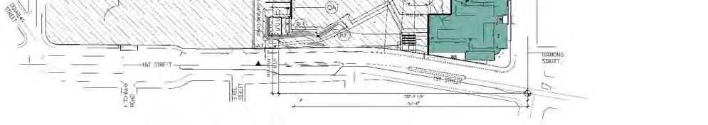
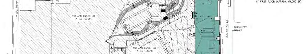
1 I. INTRODUCTION Fehr & Peers/Kaku Associates conducted a traffic study to evaluate the potential traffic impacts and parking needs of the proposed Los Angeles Unified School District (LAUSD) Human Resources Department/Professional Development Center (HRD/PDC) project on the campus of the Central Los Angeles Area New High School (CLAHS) No. 11 Vista Hermosa in the City of Los Angeles, California. This study is in support of the Supplemental Environmental Impact Report (SEIR) being prepared to evaluate the overall impacts of this project. It includes a description of the assumptions and methods used to conduct the study and a discussion of the results. DESCRIPTION The proposed project involves changes to the CLAHS No. 11 and Vista Hermosa Park project, for which an EIR was prepared in 2004 by PCR Services Corporation. The project would be on the campus of CLAHS No. 11, which is currently under construction and scheduled to be completed and occupied by November As shown in Figure 1, the CLAHS No. 11 site is immediately west of downtown Los Angeles, bounded by Temple and Colton Streets on the north, Boylston and Toluca Streets on the west, Beaudry Avenue on the east, and First Street on the south. Final EIR for the Central L.A. Area New High School No. 11 and Vista Hermosa Park (PCR Services Corporation, 2004) analyzed office space for LAUSD use as part of the CLAHS No. 11 project description. The current proposed project entails construction of two components: a new parking structure and use of the office space as office/conference space for the proposed HRD/ PDC. The proposed project includes the use of 65,000 square feet (sf) of existing space as office/conference space for use by LAUSD. About 25,500 sf of the existing office space would be devoted for use by the LAUSD HRD. The HRD facility will provide space for office, training, and testing purposes. The facility would continue to operate with a staff of approximately 78, as it 1
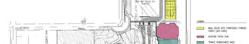
2
3 does at its currently leased space on Shatto Place. The HRD facility is expected to accommodate up to 600 exam-takers annually (12 exams per year, 50 people per exam). Adjacent to the HRD facility is the proposed PDC facility, which would consist of office space and conference rooms and could accommodate up to 350 visitors at a time. The typical operating times for the conference facility would be Mondays through Fridays during normal business hours (i.e., 8:00 a.m. to 5:00 p.m.); however, Saturday uses would also be permitted. The HRD/PDC facilities would be located in the office space along Beaudry Avenue. The north portion of the existing structure would contain the PDC conference facilities and the center, and the south portions would house the HRD offices. Parking for the HRD/PDC facilities would be provided in two locations, including a new 300-space parking structure to be constructed as part of the project and shared use of the 481-space existing parking structure constructed to serve the CLAHS No. 11 project. The proposed new parking structure would be located along Beaudry Avenue on the northern side of the CLAHS No. 11 campus. The parking structure would contain 300 spaces for use by the HRD/PDC facilities only. The 1.5-story structure would include four handball (or tennis) courts and eight multipurpose basketball/volleyball courts on the roof. Vehicular access to the parking structure would be obtained via two driveways onto Beaudry Avenue. Figure 2 illustrates the site plan for the proposed project. STUDY SCOPE The scope of analysis for this study was developed in conjunction with the Los Angeles Department of Transportation (LADOT). The base assumptions, technical methodologies, and study area were identified as part of the jointly developed study approach. The study includes an analysis of the following traffic scenarios: Existing (2007) Conditions The analysis of existing traffic conditions is intended to provide a basis for the remainder of the study. The existing conditions analysis includes an assessment of streets, traffic volumes, and operating conditions. 3

4
5 Cumulative Base Conditions Future traffic conditions are projected for the year 2009 without the proposed project. The objective of this analysis is to forecast the future traffic growth and intersection operating conditions expected to result from general regional growth and specific related projects developed in the vicinity of the project site by the year This scenario is used as the baseline against which potential project traffic impacts are evaluated. Cumulative plus Project This is an analysis of future traffic conditions with traffic expected to be generated by the proposed project added to the year 2009 cumulative base traffic forecasts. The incremental impacts of the proposed project on future traffic operating conditions can then be identified. The study area for this analysis includes the following intersections: 1. Alvarado Street & Temple Street 2. Alvarado Street & Beverly Boulevard 3. Union Avenue & Temple Street 4. Union Avenue & Beverly Boulevard 5. Belmont Avenue & Beverly Boulevard 6. Glendale Boulevard & Temple Street 7. Glendale Boulevard & Court Street 8. Glendale Boulevard & Beverly Boulevard/1 st Street/2 nd Street 9. Edgeware Road & Temple Street 10. Boylston Street & Temple Street 11. Beaudry Avenue & Sunset Boulevard 12. Beaudry Avenue & Temple Street 13. Beaudry Avenue & 1 st Street 14. Beaudry Avenue & 2 nd Street 15. Beaudry Avenue & Southbound Harbor Freeway Off-ramp 16. Alvarado Street & Sunset Boulevard (Congestion Management Program [CMP] monitoring location) 17. Temple Street & southbound Hollywood Freeway ramps The locations of the analyzed intersections are illustrated in Figure 3. A detailed intersection capacity analysis was conducted for each of these intersections under the three scenarios identified above. ORGANIZATION OF REPO This report is divided into eight chapters, including this introduction. Chapter II presents an analysis of the existing street system and traffic conditions in the study area. Forecasts of future traffic including project-generated and cumulative traffic are presented in Chapter III. Potential traffic impacts of the proposed project are discussed in Chapter IV. Chapter V 5
6
7 includes a CMP analysis of potential project impacts on the regional transportation system. Project vehicular access and circulation is discussed in Chapter VI while a parking analysis is contained in Chapter VII. Finally, a summary of the analyses and study conclusions are included in Chapter VIII. Appendices to this report include details of the technical analysis and supporting calculation worksheets. 7
8 II. CONDITIONS A comprehensive data collection effort was undertaken to develop a detailed description of existing conditions in the study area. The assessment of conditions relevant to this study includes land use, an inventory of the street and highway systems, traffic volumes on these facilities, and operating conditions at key intersections. STREETS AND HIGHWAYS Primary regional access to the study area is provided to the east and west by the Hollywood Freeway (US-101) and by the Harbor Freeway (SR-110) to the north and south. The project site is approximately 0.8 miles south of the Hollywood Freeway and 0.5 miles west of the Harbor Freeway. Area access is provided by Temple Street, Beverly Boulevard/1 st Street, Sunset Boulevard, Glendale Boulevard, Beaudry Avenue, and Alvarado Street. Local access and circulation is provided by Union Avenue, Colton Street, Boylston Street, and Toluca Street. A brief description of the principal streets serving the study area is summarized in Table 1. Diagrams of the existing lane configurations at the analyzed intersections are contained in Appendix A. TRAFFIC VOLUMES AND LEVELS OF SERVICE The following sections present the existing peak hour traffic volumes at the study intersections, a description of the methodology used to analyze the intersection traffic conditions, and the resulting level of service at each location under existing conditions. 8
9 TABLE 1 SURFACE STREET PHYSICAL CHARACTERISTICS PRIMARY STREET STA OF SEGMENT END OF SEGMENT STRIPING STOPPING & PARKING PROHIBITION (3) S (1) MEDIAN EASTBOUND/ WESTBOUND/ EB/NB WB/SB TYPE (2) NOHBOUND SOUTHBOUND Alvarado St Glendale Bl Reservoir St 2/3 2/3 DY NS 4-7PM 2HR 8AM-4PM NS 7-9AM 2HR 9AM-6PM Reservoir St Sunset Bl 2/3 2/3 DY NS 4-7PM 2HR 8AM-4PM/M NS 7-9AM 2HR 9AM-6PM Sunset Bl Kent St 2/3 2/3 DY NS 4-7PM 2HR 8AM-4PM/M NS 7-9AM 1HR 9AM-6PM/M Kent St US 101 2/3 2/3 DY NS 4-7PM 1HR 8AM-4PM NS 7-9AM 1HR 9AM-6PM US 101 Beverly Bl 2/3 2/3 DY NS 4-7PM NS 7-9AM Beverly Bl Valley St 2/3 2/3 DY NS 4-7PM NS 7-9AM Valley St 3rd St 2/3 2/3 2 NS 4-7PM 2HR 8AM-4PM/M NS 7-9AM 2HR 9AM-6PM 3rd St Maryland St 2/3 2/3 DY NS 4-7PM 2HR 8AM-4PM/M NS 7-9AM 1HR 9AM-6PM/M Maryland St 6th St 2/3 2/3 DY NS 4-7PM 1HR 8AM-4PM NS 7-9AM 1HR 9AM-6PM 6th St Wilshire Bl 2/3 2/3 DY NS 4-7PM 1HR 8AM-4PM NSAT Wilshire Bl 7th St 2/3 3 DY NS 4-7PM 1HR 8AM-4PM/M NSAT 7th St Olympic Bl 1 1 DY NS 4-7PM 1HR 8AM-4PM/M NS 7-9AM 1HR 9AM-6PM Union Av US 101 Temple St 1 2 DY 2 HR 8AM-6PM NSAT Temple St Court St 1 1 SDY PA PA Court St Council St 1 1 SDY NP 7AM-5PM SCHOOL DAYS PA Council St Beverly Bl 1 1 SDY PA PA Beverly Bl Miramar St 1 1 SDY PA NS 6AM-5PM SCHOOL DAYS Miramar St 3rd St 1 1 SDY PA 2 HR 8-6PM Belmont Av Temple St Beverly Bl 1 1 SDY PA PA Loma St Beverly Bl Belmont H.S. 1 1 SDY PA PA Glendale Bl Alvarado St Montana St 3 3 RM PA 2 HR 8-6PM Montana St Reservoir St 2 3 DY NPAT 2 HR 8-6PM Reservoir St Park St NS 4-7PM NS 7-9AM Park St Bellevue St 2 2 DY NS 4-7PM NS 7-9AM Bellivue St Palo Alto St 2 2 DY NSAT NSAT Palo Alto St Temple St 1/2 2 2 NS 3-7PM NSAT Temple St 1st/2nd St 2 2 DY NS 4-7PM NS 7-9PM Lucas Av 1st/2nd St 2nd St 2 1 DY PA PA 2nd St Miramar St 1 1 SDY PA PA Miramar St 3rd St 1 1 DY NSAT NS 7-9AM Edgeware Rd Carroll Av Temple St 1 1 DY PA PA Temple St Angelina St 1 1 SDY 1HR 8AM-6PM NS 7AM-5PM SCHOOL DAYS Angelina St Court St 1 1 SDY PA PA Boylston St North End Temple St 1 1 RM PA PA Temple St Colton St 1 1 SDY PA PA Beaudry Av Sunset Bl Temple St 1 1 SDY NS 7AM-5PM SCHOOL DAYS NS 7-9AM Temple St 1st St 2 1/2 DY NSAT NSAT (construction) 1st St 2nd St 2 1/2 DY NS 4-6PM 2HR 8AM-4PM NS 7-9AM 2HR 9AM-6PM 2nd St I-110 Ramps 2 3/2 DY NSAT NSAT I-110 Ramps 3rd St 2 3 DY NSAT NSAT 3rd St 4th St 2 2 DY NSAT NS 4-6PM NS 7-9AM 1HR 9AM-4PM/M 4th St 5th St 1 1 DY NPAT NSAT 5th St 6th St 1 2 DY NPAT 4HR 8AM-6PM
10 TABLE 1 SURFACE STREET PHYSICAL CHARACTERISTICS PRIMARY STREET STA OF SEGMENT END OF SEGMENT STRIPING STOPPING & PARKING PROHIBITION (3) S (1) MEDIAN EASTBOUND/ WESTBOUND/ EB/NB WB/SB TYPE (2) NOHBOUND SOUTHBOUND Sunset Bl Rampart Bl Rosemont Av HR 8AM-6PM 1HR 8AM-6PM Rosemont Av Park Av 2 2 DY 1HR 8AM-6PM/M 1HR 8AM-6PM/M Park Av Lemoyne St 2 2 DY 1HR 8AM-6PM/M 2HR 8AM-6PM/M Lemoyne St Laveta Ter 2 2 DY 2HR 8AM-6PM/M 2HR 8AM-6PM/M Laveta Ter Portia St HR 8AM-6PM/M 2HR 8AM-6PM Portia St Douglas St HR 8AM-6PM/M PA Douglas St Elysian Park Av PA 1HR 8AM-6PM Elysian Park Av Marion Av 2/3 2 2 NS 7-9AM 1HR 9AM-6PM NS 4-7PM Marion Av Beaudry Av 2/3 2/3 2 NS 7-9AM NS 4-7PM Beaudry Av Custer Av 2/3 2/3 2 NS 7-9AM 1HR 9AM-6PM NS 4-7PM 1HR 8AM-4PM Custer Av Figueroa St 2/3 2/3 2 NS 7-9AM 6HR 9AM-6PM NS 7-9AM 4-7PM 10HR 9AM-4PM Temple St Rosemont Av Union Av 2 2 DY 1HR 8AM-6PM 1HR 8AM-6PM Union Av Beaudry Av 2 2 DY NS 7-9AM 1 HR 9AM-6PM NS 4-6PM 1HR 8AM-4PM Beaudry Av Figueroa St NSAT NSAT Court St Union St Glendale Bl 1 1 SDY PA PA Glendale Bl Patton St 1 1 SDY PA NS 7AM-5PM SCHOOL DAYS Patton St Boylston 1 1 SDY PA PA Colton St Belmont Av Beaudry Av 1 1 None PA PA Rosemont Av Rampart Bl HR 8AM-6PM 1HR 8AM-6PM Beverly Bl/1st St Rosemont Av Alvarado St 2/3 2/3 2 NS 7-9AM NS 4-6PM Alvarado St Bonnie Brae St 2/3 2/3 2 NS 7-9AM NS 4-6PM Bonnie Brae St Belmont Av 2/3 2/3 2 NS 7-9AM NS 4-6PM Belmont Av Witmer St NS 7-9AM NS 4-6PM Witmer St Edgeware Rd 2 2 DY NSAT NSAT Edgeware Rd Bixel St 2 2 DY NS 7-9AM NSAT Bixel St Beaudry Av 1 1 DY NSAT NSAT (construction) Beaudry Av Freemont Av 2 2 DY NSAT NSAT Freemont Av Figueroa St 3 2 DY NSAT NSAT 2nd St Glendale Bl Boylston St HR 8AM-6PM 2HR 8AM-6PM Boylston St Beaudry Av HR 8AM-6PM 2HR 8AM-6PM Beaudry Av Figueroa St 2 2/3 2 2HR 8AM-6PM 2HR 8AM-6PM/M (1) S: # # 0F S (3) PARKING: /M METERED PARKING #/# OFF-PEAK/PEAK PERIOD NUMBER OF S PA PARKING ALLOWED NPAT NO PARKING ANY TIME NSAT NO STOPPING ANY TIME (2) MEDIAN TYPES: DY DOUBLE YELLOW CENTERLINE NS NO STOPPING 2 2-WAY LEFT TURN RM RAISED MEDIAN SDY SINGLE DASHED YELLOW CENTERLINE NONE NO CENTER MEDIAN
11 Existing Traffic Volumes Weekday morning and afternoon peak hour traffic counts were conducted at the 17 study intersections in December 2007 as part of this study. Traffic count data sheets are contained in Appendix B and the existing traffic volumes are illustrated in Figure 4. Level of Service Methodology Level of service (LOS) is a qualitative measure used to describe the condition of traffic flow, ranging from excellent conditions at LOS A to overloaded conditions at LOS F. LOS D is typically considered to be the minimum acceptable LOS in urban areas. LADOT requires that the "Critical Movement Analysis" (CMA) method (Transportation Research Board, 1980) of intersection capacity analysis be used to determine the intersection volume-tocapacity (V/C) ratio and corresponding LOS for the given turning movements and intersection characteristics at signalized intersections. The software package developed by LADOT was used to implement the CMA methodology in this study. Table 2 defines the ranges of V/C ratios and their corresponding LOS using the CMA method. All but one of the study intersections are currently signalized and controlled by the City of Los Angeles Automated Traffic Surveillance and Control (ATSAC) system. In accordance with LADOT procedures, a capacity increase of 7 percent (0.07 V/C adjustment) was applied to reflect the benefits of ATSAC control at these intersections. LADOT will be implementing the City s Adaptive Traffic Control System (ATCS) at each of the signalized study intersections. In accordance with LADOT procedures, an additional capacity increase of 3 percent (0.10 total V/C adjustment including both ATSAC and ATCS) was applied to these intersections in the analysis of future conditions in Chapter IV. The unsignalized intersection (Boylston Street & Temple Street) was analyzed using the CMA method and a reduced capacity value of 1,200 vehicles per hour per lane. 11
12
13 TABLE 2 LEVEL OF SERVICE DEFINITIONS FOR SIGNALIZED INTERSECTIONS Level of Service Volume/Capacity Ratio Definition A EXCELLENT. No vehicle waits longer than one red light and no approach phase is fully used. B VERY GOOD. An occasional approach phase is fully utilized; many drivers begin to feel somewhat restricted within groups of vehicles. C GOOD. Occasionally drivers may have to wait through more than one red light; backups may develop behind turning vehicles. D FAIR. Delays may be substantial during portions of the rush hours, but enough lower volume periods occur to permit clearing of developing lines, preventing excessive backups. E POOR. Represents the most vehicles intersection approaches can accommodate; may be long lines of waiting vehicles through several signal cycles. F >1.000 FAILURE. Backups from nearby locations or on cross streets may restrict or prevent movement of vehicles out of the intersection approaches. Tremendous delays with continuously increasing queue lengths. Source: Transportation Research Board.
14 Existing Peak Hour Levels of Service The existing weekday morning peak hour turning movements presented in Figure 4 were used in conjunction with the LOS methodology described above to determine existing operating conditions at each of the study intersections. LOS calculation worksheets are included in Appendix C. Table 3 summarizes the a.m. and p.m. peak hour V/C ratios and corresponding LOS at each of the study intersections. The results of this analysis indicate that 15 of the 17 intersections are currently operating at acceptable LOS (i.e., LOS D or better) during both the morning and the afternoon peak hour. The two intersections currently operating at unacceptable levels of service during one or both peak hours are Glendale Boulevard & Temple Street and Beaudry Avenue & Sunset Boulevard. PUBLIC TRANSIT The project area is served by 13 Los Angeles County Metropolitan Transportation Authority (Metro) bus lines, two Metro rail lines, and three LADOT Downtown Area Shuttle (DASH) lines. The bus routes are described below: Metro Lines 2/4/302/304 Travel on Sunset Boulevard and Caesar Chavez Avenue in the northern portion of the project area. Metro Lines 10/11 Travel on Temple Street in the northern portion of the project area. Metro Line 14 Travels on 1 st Street in the southern portion of the project area. Metro Lines 16/316 Travels on 3 rd Street in the southern portion of the project area. Metro Lines 60/360 Travel on Figueroa Street in the eastern portion of the project area. Metro Line 92 Travels on Temple Street, Edgeware Road, and Bellevue Avenue in the northern portion of the project area. Metro Line 445 Travels on Hope Street in the eastern portion of the project area. Metro Red Line Travels on Hill Street in the southeastern portion of the study area. The station closest to the project site is the Civic Center station, at Hill Street & 1 st Street, about 0.6 miles from the project site. 14
15 TABLE 3 INTERSECTION LEVEL OF SERVICE ANALYSIS CONDITIONS Intersection * 1. Alvarado St & Temple St * * * * * * * * * * * * * * * Alvarado St & Beverly Bl Union Av & Temple St Union Av & Beverly Bl Belmont Av/Loma Dr & Beverly Bl Glendale Bl & Temple St Glendale Bl & Court St Glendale Bl/Lucas Av & Beverly Bl/2nd St Edgeware Rd & Temple St Boylston St & Temple St [a] Beaudry Av & Sunset Bl Beaudry Av & Temple St Beaudry Av & 1st St Beaudry Av & 2nd St Beaudry Av & SB SR-110 Off-ramp Alvarado St & Sunset Bl [b] Temple St & SB US-101 ramps Peak Existing Hour V/C LOS Notes: [a] Intersection is controlled by stop signs. Stop-controlled intersection analysis was performed using the CMA methodology and a reduced capacity of 1,200 vehicles per hour per lane. [b] Denotes CMP arterial monitoring station. * Intersection is currently operating under ATSAC system. A.M. P.M. A.M. P.M. A.M. P.M. A.M. P.M. A.M. P.M. A.M. P.M. A.M. P.M. A.M. P.M. A.M. P.M. A.M. P.M. A.M. P.M. A.M. P.M. A.M. P.M. A.M. P.M. A.M. P.M. A.M. P.M. A.M. P.M C B B C C B A A A A A A E F C C A D A D A A C E B D A D A A C D C B
16 Metro Blue Line Travels on Flower Street in the southeastern portion of the study area. The station closest to the project site is the Metro Center station, located at Flower Street & 7 th Street, less than one mile from the project site. The Blue Line can also be reached via the Red Line and Gold Line. LADOT DASH Lines A/B Travel on Hope Street, Grand Avenue, and 1 st Street in the eastern portion of the project area. LADOT DASH Line F Travels on 3 rd Street, Figueroa Street, and Beaudry Avenue in the southern portion of the project area. 16
17 III. FUTURE TRAFFIC IONS Fehr & Peers/Kaku Associates developed estimates of future traffic conditions in the area both with and without the proposed project in order to properly evaluate the potential impact of the proposed project on the local street system. Future traffic volumes are first estimated for the study area without the project. These future forecasts reflect traffic increases due to general regional growth and traffic expected to be generated by other future developments in the vicinity of the project and represent cumulative base conditions. The addition of project traffic to the cumulative base reflects the cumulative plus project conditions. CUMULATIVE BASE TRAFFIC IONS The cumulative base traffic projections reflect anticipated future traffic increases that can be expected from two sources. The first is the ambient growth in traffic, which reflects general increases in traffic due to regional growth and development. The second source is traffic generated by specific future projects in or near the study area. The methods and assumptions used to develop the cumulative base traffic projections are described below. Areawide Traffic Growth Existing traffic is expected to increase between year 2007 and year 2009 as a result of general area-wide and regional growth and development. Based on historical trends, LADOT recommends an ambient traffic growth factor of 1 percent per year be used to adjust the existing year 2007 traffic volumes to reflect the effects of regional growth and development by the year
18 Traffic Generation of Cumulative Development Projects Information regarding potential future projects that are either under construction, planned, or proposed for development in or near the study area was obtained from the LADOT related projects database. The cumulative projects are described in Table 4, and their locations are illustrated in Figure 5. As shown in Table 4, a total of 85 cumulative development projects were identified. For the purposes of this analysis, development of the CLAHS No. 11/Vista Hermosa Park project is included as a cumulative project. Projected weekday a.m. peak hour and p.m. peak hour trip generation estimates for the majority of the related projects were also obtained from the LADOT related projects database. In/out split data from Trip Generation, 7 th Edition (Institute of Transportation Engineers, 2003) was also used to split the total peak hour trips for each project into inbound and outbound trips. As shown in Table 4, the 85 cumulative projects are projected to generate a total of almost 17,000 trips during the a.m. peak hour and approximately 22,500 trips during the p.m. peak hour. The geographic distribution of traffic generated by developments such as those included in this analysis depend on several factors. These factors include the type and density of the proposed land uses, the geographic distribution of the population from which employees and/or patrons of proposed commercial developments may be drawn, the geographic distribution of activity centers (employment, commercial, and other) to which residents of proposed residential projects may be drawn, and the location of the project in relation to the surrounding street system. Cumulative Base Traffic Volumes Forecasts of cumulative base traffic volumes were developed by adding the traffic expected to be generated by the list of cumulative development projects to the background existing volumes adjusted by areawide traffic growth. The resulting traffic volumes at the 17 analyzed intersections, as illustrated in Figure 6, represent the Year 2009 cumulative base conditions, i.e., future conditions without the project. 18
19 TABLE 4 CUMULATIVE S TRIP GENERATION Map No. Project Name AM Peak Hour PM Peak Hour Source In Out Total In Out Total 1 Staples Entertainment District 3.5M sf(1200 rm hotel, 3600 seat cinema, 7000 seat theater, 345,000sf restaurant, 498,000sf retail, 165,000sf office, 800du apts) 2,808 2,408 5,213 4,002 3,308 7,309 [4] 2 Commercial & residential development Construct mixed use 10,000 sf commercial on ground levels, and 330 residential apts. on 5 levels above ground [5] 3 Quality Restaurant & nightclub Construct 7,142 sf quality restaurant and nightclub in existing office bldg w/18 on-site & 100 off-site parking space [1] 4 Medical Center/Clinic Construct 6-story 31,655 sf clinic w/off site parking space [1] 5 Auto Sales Construct 25,880sf auto sales and parking lot [1] 6 Mixed use Construct 12,500 SF retail, 210 dwelling units [1] 7 Apartments Construct 300 units apartment [1] 8 Mix use Construct 110 units apartment & 10,000 SF retail [1] 9 Mixed use Construct 600 dwelling units apartment & 30,000 Sf retail [1] 10 Mixed use Construct 50 unit condos & 18,000 SF retail [1] 11 Mixed use Construct 417 unit condos, 15,000 SF retail [1] 12 Quality restaurant & bar Construct 8,891 sf quality restaurant & 7,668 sf bar [1] 13 Mixed use project Construct 204 DU & 5k SF retail [1] 14 Blossom Plaza - Mixed use project Construct 223 unit condos, 22,008 SF retail, 175KSF restaurant, (9K sit-down & 6K fast-food), 7K SF cultural ctr, & 617 pkg spcs [1] 15 Restaurant Construct 8908 SF restaurant [1] 16 Condos & retail Construct 87 unit condos & SF retail [1] 17 Condos Construct 311 unit condos [1] 18 Bar/Lounge Construct 8.77K SF bar/lounge [1] 19 Mixed-use Construct 17-story mixed-use bldg: 105 DU condos & 4.5K SF retail [1] 20 Medical office addition Construct 3-story 24,075 addition to existing 5-story 109,840 med. bldg [1] 21 Mixed-use project (project formerly only 80 Apts) Construct 130 condos & 7037 SF retail [1] 22 Supermarket & Retail Renovate existing fast food rest. w/ drive-thru & construct 17K SF supermarket & 4.2K SF retail space on vac. 38K SF site [1] 23 Hall of Justice Retrofit Hall of Justice Bldg: from 1630 to 1660 employees plus 1000 pkg spc struct [1] 24 Gratts Primary Ctr & Early Education Ctr Construct 380 student school [1] 25 Lorenzo Res Development Construct 600 res units & 20K SF retail [1] 26 Zen Mixed-Use Project Construct 330 condos, 2.8K SF retail, 9.2K SF restaurant & 56.2K SF health club [1] 27 Mixed-Use Construct 200 apts & 5K SF retail [1] 28 Prop Q & F Public Safety Civic Ctr Facility Plan (Jail) Construct 179K SF Metro Jail (Trips also include Police HQs facility plan) [6] 29 Prop Q & F Public Safety Civic Ctr Facility Plan (EOC) Construct 82K SF EOC-POC-FDC, 210-space parking structure & 30SF Med Servs Division facility (For trips see Metro Jail) Included in related project number 28 [6] 30 LAUSD ELA High School #1 Construct 1,206 student high school [1] 31 Mixed-Use Construct 156 apts & 7.5K SF retail [1] 32 Mixed-Use Construct 128 condos, 3472 SF retail, 2200 SF other [1] 33 Mixed-Use Construct 374 condos, SF retail [1] 34 Mixed-Use Construct 570 condos, 280 apts, & 50K SF retail [1] 35 Mixed-Use Construct 629 condos & 27K SF retail [1] 36 Chinatown condos Construct 300 condos [1] 37 LAUSD - Central LA High School #12 Construct 500 student high school [1] 38 Almond Tree Village Construct 147 condos, 261 apts (sr hsg), 20K SF retail [1] 39 Mixed-Use Construct 60 condos & 6K SF retail [1] 40 LAUSD - Cen Reg Elem School #14 Construct 875 student elementary school (NWC of intersection) [1] 41 Metropolis Mixed-Use Construct 836 condos, SF office, 480 hotel rms, 46K SF retail [1] 42 Police HQ Facility Plan (PHF) Construct PHF 500K GSF facility incl. 350-seat auditorium, 5.34K SF cafe, 700-spc subterr garage (Trips for whole project) [1] 43 Police HQ Facility Plan (Main St Pkg Facility) Construct 640-spc garage (500 PHF employees & 140 public) Motor Transport Div, and rec ctr Included in related project number 28 [6] 44 Police HQ Facility Plan (Aiso St Pkg Facility) Construct 300-spc public pkg garage Included in related project number 28 [6] 45 Chinatown Gateway Project Construct 280 apts & 22K SF retail [1] 46 Mixed-Use (Herald Examiner) Construct 20 apts, SF office, SF retail, & 565 condos [1] 47 8th & Grand Mixed-Use project Construct 875 condos, retail, & 10K SF restaurant [1] 48 Restaurant, retail, and health club ( E 6th St) Construct 5 sep. establishments incl. a 11,018 SF restaurant, 8,927 SF retail, and SF Health Club in the same bldg [1] 49 Mixed-use Construct 363-unit apts & 7740 SF retail [1] 50 Mixed-use development Construct SF restaurant, 726 SF retail, 726 SF pool/lounge/event ctr [1] 51 Condos Construct 300 condos & 3.4K SF retail [1] 52 Mixed-use development Construct 190-live/work unit condo & 5540 SF retail space [1] 53 Mixed-use development Construct 118 condos & 3000 SF retail space [1] 54 Bus Maintenance & Inspection Facility Construct 2-acre bus maintenance & inspection facility [1] 55 Mixed-use development Construct 402 condos & 4728 SF retail space [1] 56 Mixed-use development Construct 130 condos & 7037 SF retail [1] 57 Mixed-use Construct 65 condos [1] 58 Mixed-use Construct 600 apts & 30K SF retail [1] 59 FIDM Campus Expansion Construct 95.7K SF school expansion & 112 apts [5] 60 PUC Charter School Construct school for 550 elementary student & 230 middle school student [1] 61 Mixed-use Construct 210 condos & 9K SF retail [1] 62 Grand Avenue Implementation Plan (mixed-use) Construct 1648 condos, 412 apts, 449K SF retail, 275 hotel rms, 68K SF County Office 321 1,005 1, ,716 2,270 [1] 63 Wholesale mart Construct SF wholesale mart [1] 64 Mixed-use Construct 420 condos & 40K SF retail [1] 65 Bunker Hill Mixed-Use Construct 272 condos, 6431 SF retail & 8K SF restaurant [1] 66 Condos Construct 39 condos [1] 67 2 Hi-rise Condo Bldgs Construct 622 condos [1] 68 2 Hi-rise Condo Bldgs Construct 622 condos [1] 69 Witmer Project Construct 186 condos & 6.2K SF retail [1] 70 Condos (TT67738) Construct 102 condos [1] 71 Condos & retail (VTT67122) Convert lt. man., off., & retail 8539 SF bldg. to 96 condos & 7.8KSF retail [1] 72 One Santa Fe Project (Mixed-Use) Construct 442 apts, 17 live/work units, 25 ksf retail and restaurant [1] 73 Mixed-used Development Construct 247 condominiums & 10,675 SF retail [1] 74 Mixed-used Development Construct 159 condominiums & 6,827 SF restaurant [1] 75 Mixed-use residential, retail and restaurant Construct 351 condos, 12.5KSF retail & 12.5KSF restaurant [1] 76 Mixed-use residential, hotel, retail and restaurant Construct 225 condominiums, 200 rooms Hotel, sf retail, and sf restaurant [1] 77 Mixed-use residential and retail Construct 172 condominiums and 6850 sf retail [1] 78 Mixed-use hotel, residential, retail and restaurant Construct 80-room hotel, 112 unit condo hotel, 165 unit condo, 7500 sf retail and sf restaurant [1] 79 Gas Station with Mini-Market Demo exist SF serv. stn. bldg. w/ mini-mkt & reconstruct 2046 SF gas stn (8 VFP) w/ canopy & mini-mkt w/ 25 pkg spcs [1] 80 Park Fifth Project Construct 900 condos 19K SF retail & 19.2 KSF restaurants [1] 81 Condos Construct 46 condos [1] 82 MacArthur Park/Alvarado Metro Project Construct Ph 1-90 apts & 15.5ksf retail; Ph 2-82 apts & 17.3ksf retail [1] 83 Mixed-Use Construct 32 apts & 5870 SF Retail [1] 84 Affordable apartments Construct 75 unit affordable housing [1] 85 CLAHS #11 and Vista Hermosa Park Project Construct 2,600 student high school, 70,000 SF office space, and 10.5 acres park [2] Total [3] Project Description Notes: 1. Total peak hour trips obtained from LADOT related projects trip database. Peak hour trip distribution based on the Trip Generation, Seventh Edition, Institute of Transportation Engineers, The trip generation estimates are obtained from Traffic Study for the Central Los Angeles Area New High School # 11 and Vista Hermosa Park Project, Kaku Associates, Inc., January Total peak hour trips for related projects within a 2-mile radius of the project study area. 4. Trip generation estimates are obtained from Traffic Study for the Bunker Hill Design for Development Program EIR, Kaku Associates, Inc Source: Trip Generation, Seventh Edition, Institute of Transportation Engineers (ITE), Trip generation estimates are obtained from Traffic Study for the Police Headquarters Facility Plan, Kaku Associates, Inc., ,681 10,278 16,956 12,157 10,376 22,532
20
21
22 TRAFFIC VOLUMES Development of future traffic forecasts for the proposed project uses a three-step process similar to the process described for the related projects. The process estimates the project s trip generation, trip distribution, and traffic assignment. Project Trip Generation The proposed project includes the use of 65,000 sf of existing space for use by LAUSD. About 25,500 sf of the existing office space would be devoted to use by the HRD, and approximately 39,500 sf of space would be used by the PDC as a conference facility. Trip generation for the office portion of HRD facility was developed using the Trip Generation, 7 th Edition trip rates. The HRD is expected to conduct up to 12 exams per year, with 50 people per exam. The trip generation estimates for the examination facility were developed assuming that as many as two sessions could occur on a given day, with the first session arriving during the a.m. peak hour and the second session departing during the p.m. peak hour. The conference facility at the PDC is proposed to accommodate up to 350 visitors at any given time. For trip generation purposes, two sessions were assumed to be held on a given day, with 50% of the morning session visitors assumed to arrive during the a.m. peak hour and 50% of the afternoon session visitors assumed to depart during the p.m. peak hour. The trip generation estimates for the exam visitors and the PDC visitors assume an average vehicle ridership (AVR) of 1.40 persons per vehicle. AVR indicates the average number of people traveling per each vehicle and takes into consideration the people who carpool, walk, or use transit in the numerator. An AVR of 1.40 suggests that approximately 71% of the visitors are drivers, with the remaining 29% either passengers in a vehicle or taking alternative modes such as transit (as an example, an AVR of 1.40 would be equivalent to an average vehicle occupancy of 1.1 persons per vehicle with a 21% transit mode share or 1.2 persons per vehicle with a 14% transit mode share or 1.25 persons per vehicle with an 11% transit mode share). 22
23 Table 5 presents the trip generation rates and resulting trip generation estimates for the proposed project. As indicated in the table, the trips generated by the office component originally analyzed as part of the Final EIR for the CLAHS No. 11 project (as estimated in Traffic Study for the Central Los Angeles Area New High School # 11 and Vista Hermosa Park Project, Kaku Associates, Inc., January 2004) have been discounted. Accordingly, the proposed project is expected to generate a net increase of approximately 653 daily trips, including approximately 92 in the weekday a.m. peak hour and 95 in the weekday p.m. peak hour over the level of trips estimated for the same space in the CLAHS No. 11 Final EIR. Project Trip Distribution The geographic distribution of traffic generated by developments such as those included in this analysis is dependent on several factors. These factors include the type and density of the proposed land uses, the geographic distribution of the population from which the employees and visitors may be drawn, the location of site access points in relation to the surrounding street system, the level of congestion on local streets, and the physical characteristics of the street system. The regional trip distribution patterns for the project were based on the LADOT-approved Traffic Study for the Central Los Angeles Area New High School # 11 and Vista Hermosa Park Project. The resulting trip distribution patterns for the proposed HRD/PDC facilities, similar to trip distribution patterns developed for the CLAHS # 11 project for the office element, is illustrated in Figure 7. Project Trip Assignment The project trip generation estimates summarized in Table 5 and the distribution patterns illustrated in Figure 7 were used to assign the project-generated traffic to the local and regional street system and through the 17 study intersections. Figure 8 illustrates the assignment of the proposed project-generated peak hour traffic volumes at each of the study intersections during a typical weekday peak hour. 23
24 Proposed Project TABLE 5 TRIP GENERATION ESTIMATES CLAHS #11 HUMAN RESOURCES DEPAMENT/PROFESSIONAL DEVELOPMENT CENTER Trip Generation Rates Estimated Trip Generation Land Use Size ITE Daily A.M. Peak Hour P.M. Peak Hour A.M. Peak Hour P.M. Peak Hour Code Rate Rate % In % Out Rate % In % Out Daily Trips In Out Total In Out Total Human Resources Department Office Use [a] 25.5 ksf % 12% % 83% Examination Facility [b, c] 50 visitors % 0% % 100% * 36 * Professional Development Center Conference Facility [c, d] 350 visitors % 0% % 100% 1, * 125 * Total New Uses 1, Previously Proposed Use [e] Office Space [a] ksf % 12% % 83% (771) (96) (13) (109) (18) (86) (104) Net Incremental Trips (8) 92 (12) Notes: * Negligible. [a] Trip generation rates obtained from the Trip Generation, Seventh Edition, Institute of Transportation Engineers, [b] Up to two sessions of 50 visitors are estimated to take place on a given day. One session is assumed to arrive in the AM peak hour and the second session is assumed to leave in the P.M. peak hour. [c] The trip generation estimates are based on average vehicle ridership (AVR). AVR indicates the average number of people traveling in a vehicle and takes into account the people who carpool, walk, or use transit in the numerator. An AVR of 1.40 is assumed in this case. [d] The conference facility is proposed to accommodate two sessions of 350 visitors. 50% of the morning session visitors are assumed to arrive in the AM peak hour and 50% of the afternoon session visitors are assumed to leave in the PM peak hour. [e] Trips generated by the existing office component as estimated in Traffic Study for the Central Los Angeles Area New High School # 11 and Vista Hermosa Park Project, Kaku Associates, Inc., January 2004, have been discounted. The study assumed 70,000 square feet of office space.
25
26
27 CUMULATIVE PLUS TRAFFIC IONS The proposed project generated traffic volumes in Figure 8 were then added to the cumulative base traffic volumes, resulting in the cumulative plus project traffic volumes for the proposed project. Figure 9 illustrates the resulting projected cumulative plus project a.m. peak hour traffic volumes. These volumes represent projected future weekday peak hour traffic conditions including the completion of the proposed project. 27
28
29 IV. INTERSECTION IMPACT ANALYSIS This section presents an analysis of the potential impacts of the proposed project on the local street system. The analysis compares the projected LOS at each study intersection with the proposed project to the cumulative base (no project) scenario to determine potential project impacts, using significance criteria established by the City of Los Angeles. INTERSECTION SIGNIFICANT IMPACT CRITERIA The City of Los Angeles established threshold criteria that determine whether a project has a significant traffic impact at a specific intersection. Under the City s guidelines, a project impact would be considered significant if the following conditions are met: Intersection Condition With Project Traffic Project-Related Increase LOS V/C Ratio in V/C Ratio C > Equal to or greater than D > Equal to or greater than E, F > Equal to or greater than CUMULATIVE BASE TRAFFIC CONDITIONS The results of the analysis of the 17 intersections under the cumulative base traffic conditions are summarized in Table 6. The table indicates that eight of the 17 intersections would operate at LOS E or F during either the morning peak hour or afternoon peak hour or both. These eight intersections are: Glendale Boulevard & Temple Street Glendale Boulevard/Lucas Avenue & Beverly Boulevard/2 nd Street Edgeware Road & Temple Street 29
30 TABLE 6 INTERSECTION LEVEL OF SERVICE ANALYSIS CUMULATIVE BASE AND CUMULATIVE PLUS CONDITIONS Intersection * 1. Alvarado St & Temple St * * * * * * * * * * * * * * Alvarado St & Beverly Bl Union Av & Temple St Union Av & Beverly Bl Belmont Av/Loma Dr & Beverly Bl Glendale Bl & Temple St Glendale Bl & Court St Glendale Bl/Lucas Av & Beverly Bl/2nd St Edgeware Rd & Temple St Boylston St & Temple St [a] Beaudry Av & Sunset Bl Beaudry Av & Temple St Beaudry Av & 1st St Beaudry Av & 2nd St Beaudry Av & SB SR-110 Off-ramp Alvarado St & Sunset Bl [b] Temple St & SB US-101 ramps Peak Hour A.M. P.M. A.M. P.M. A.M. P.M. A.M. P.M. A.M. P.M. A.M. P.M. A.M. P.M. A.M. P.M. A.M. P.M. A.M. P.M. A.M. P.M. A.M. P.M. A.M. P.M. A.M. P.M. A.M. P.M. A.M. P.M. A.M. P.M. Notes: [a] Intersection is controlled by stop signs. Stop-controlled intersection analysis was performed using the CMA methodology and a reduced capacity of 1,200 vehicles per hour per lane. [b] Denotes CMP arterial monitoring station. * Intersection assumed to operate under ATCS as future baseline condition. Cumulative Base V/C LOS C D D C A A A A A A F F D D A E B E B B D F E E B F D E A A D E D B Cumulative Project V/C LOS C D D C A B E B A A A A A F F D D B E B E E D B F F D E A A D E D B Project Increase in V/C Significant Project Impact NO NO NO NO NO NO NO NO NO NO NO NO NO NO NO NO NO NO NO NO NO NO YES YES NO NO NO NO NO NO NO NO NO NO
31 Beaudry Avenue & Sunset Boulevard Beaudry Avenue & Temple Street Beaudry Avenue & 1 st Street Beaudry Avenue & 2 nd Street Alvarado Street & Sunset Boulevard (CMP monitoring location) This represents a deterioration in operating conditions from existing conditions since, as discussed in Chapter II (Table 2), only two of the intersections currently operate at LOS E or F during the morning peak hours. Background traffic growth and traffic generated by related projects is expected to adversely impact operating conditions at intersections in the study area even without consideration of potential traffic associated with the proposed project. CUMULATIVE PLUS TRAFFIC ANALYSIS The cumulative plus project peak hour traffic volumes illustrated in Figure 9 were analyzed to determine the projected year 2009 future operating conditions with the completion of the proposed project. Application of the significance criteria established by the City of Los Angeles indicates that the project would have a significant traffic impact during the a.m. and p.m. peak hours at the following intersection: Beaudry Avenue & Temple Street MITIGATION MEASURES The traffic impact analyses above determined the proposed HRD/PDC project is projected to cause a significant impact at Beaudry Avenue & Temple Street during the a.m. and p.m. peak hours. No feasible physical mitigation measures have been identified for this location that could be constructed within the available right-of-way and, given the built-out nature of the area, acquisition of right-of-way is for this location is not considered feasible. Therefore, the project impact at this location would be significant and unavoidable. 31
32 V. REGIONAL IMPACT ANALYSIS Additional analyses were conducted to comply with Metro s CMP requirements. In accordance with CMP Transportation Impact Analysis (TIA) requirements, potential impacts of the proposed project on the regional transportation system, including the freeway system, CMP arterial intersection monitoring stations, and the regional transit system, were evaluated. This analysis was conducted in accordance with the TIA procedures outlined in 2004 Congestion Management Program for Los Angeles County (Metro, January 2004). The CMP requires that, when an EIR is prepared for a project, traffic and transit impact analyses be conducted for select regional facilities based on the quantity of project traffic expected to use these facilities. CMP TRAFFIC IMPACT ANALYSIS The CMP guidelines require that the first issue to be addressed is the determination of the geographic scope of the study area. The criteria for determining the study area for CMP arterial monitoring intersections and for freeway monitoring locations are the following: All CMP arterial monitoring intersections where the proposed project will add 50 or more trips during either the morning or evening weekday peak hours of adjacent street traffic. All CMP mainline freeway monitoring locations where the proposed project will add 150 or more trips in either direction during either of the weekday peak hours. The CMP arterial monitoring intersection nearest to the project site is the intersection of Alvarado Street & Sunset Boulevard. Based on the project trip generation estimates previously presented and a review of the project traffic volumes shown in Figure 8, the proposed project is not expected to add more than 50 vehicles per hour (vph) to either of these two locations during either peak hour. Therefore, a CMP arterial intersection analysis is not required. 32
33 A regional analysis was also conducted to quantify potential impacts of the project traffic on the regional freeway system. This assessment included the Santa Monica Freeway (I-10), the Hollywood Freeway (US-101), and the Harbor Freeway (SR-110). According to the incremental project trip generation estimates developed in Chapter III, the proposed project is not expected to add new traffic sufficient to exceed the freeway analysis criteria at these locations. Since incremental project-related traffic in any direction during either peak hour is projected at well below the minimum criteria of 150 vph, no further CMP freeway analysis is required. TRANSIT IMPACT ANALYSIS Potential increases in transit person trips generated by the proposed project were estimated. Appendix B-4 of the CMP provides a methodology for estimating the number of transit trips expected to result from a proposed project based on the projected number of vehicle trips. This methodology assumes an AVR factor of 1.4 in order to estimate the number of person trips to and from the project and then provides guidance regarding the percent of persons trips assigned to public transit depending on the type of use (commercial/other versus residential) and the proximity to transit services. As discussed in Chapter III and shown in Table 5, the proposed project is expected to generate a net increase of approximately 92 vehicles during the weekday a.m. peak hour and 95 vehicles during the weekday p.m. peak hour. After applying the CMP guidelines described above (i.e., converting the vehicle trips to person trips by multiplying by a 1.4 AVR and assuming 10% transit use), the project could add approximately 13 new transit person trips in the weekday a.m. peak as well as in the weekday p.m. peak hour. The project area is well-served by existing transit routes, with approximately 13 Metro bus lines and three LADOT DASH lines serving the area and the Metro Red Line Civic Center station approximately 0.6 miles from the project site. Project-related impacts on the regional transit system are not expected to be significant. 33
34 VI. ACCESS AND CIRCULATION Users of the HRD/PDC facility would park in a new 300-space garage to be constructed as part of the project along Beaudry Avenue on the northern portion of the CLAHS No. 11 site. They would also share use of the 481-space parking structure constructed as part of the CLAHS No. 11 project. Vehicular access to the existing 481-space parking structure would be obtained via two driveways on Beaudry Avenue, one located north of Diamond Street and the second located opposite Mignonette Street, and one driveway on 1 st Street. Per the Final EIR for the CLAHS No. 11 project, the 1 st Street driveway will be limited to right-turn-in/right-turn-out only via construction of a short median island on 1 st Street (this island has already been constructed). Per the Final EIR for the CLAHS No. 11 project, Beaudry Avenue is to be improved to modified Major Highway standards. The Civic Center West Specific Plan (CCWSP) includes a planned landscaped median island on Beaudry Avenue from Sunset Boulevard to 4 th Street. However, consistent with the prior agreement, the CLAHS No. 11 project does not provide for, but would not preclude, a future raised median island. LAUSD has proposed a two-way left-turn painted median and would require continued turn movement access in the event a raised median is later instituted by the City. To enhance traffic flow and prevent traffic hazards, left-turn ingress would be permitted at the northern driveway opposite Mignonette Street. However, because the proximity of the southern project driveway to 1 st Street limits the capacity to queue left-turning vehicles in the median, left-turn ingress would not be permitted at the southernmost driveway. Left-turn egress would be permitted from both driveways. Vehicular access to the new 300-space parking structure to be constructed as part of the project would be provided via two new driveways onto Beaudry Avenue, one at either end of the structure. The raised median island contemplated in the CCWSP, if implemented at some point in the future, could limit these driveways to right-turn-in/right-turn-out only, which would lead to circuitous travel, particularly for motorists arriving to the site from the south and motorists exiting the site who desire to turn left to travel north on Beaudry Avenue. Given the nature of the street system, limited options for turning around in the vicinity of the project site would likely lead to 34
TRANSPORTATION STUDY FOR THE 8899 BEVERLY BOULEVARD PROJECT
 DRAFT TRANSPORTATION STUDY FOR THE 8899 BEVERLY BOULEVARD PROJECT WEST HOLLYWOOD, CALIFORNIA NOVEMBER 2013 PREPARED FOR BEVERLY BOULEVARD ASSOCIATION PREPARED BY DRAFT TRANSPORTATION STUDY FOR THE 8899
IV. ENVIRONMENTAL IMPACT ANALYSIS J. TRANSPORTATION AND TRAFFIC
 IV. ENVIRONMENTAL IMPACT ANALYSIS J. TRANSPORTATION AND TRAFFIC This Section summarizes the information provided in the Traffic Study for the Santa Monica College Bundy Campus Master Plan (Traffic Study),
IV. ENVIRONMENTAL IMPACT ANALYSIS L. TRANSPORTATION/TRAFFIC
 IV. ENVIRONMENTAL IMPACT ANALYSIS L. TRANSPORTATION/TRAFFIC INTRODUCTION The following section summarizes the information provided in the traffic report entitled Traffic Impact Analysis for a Proposed
Traffic Impact Analysis 5742 BEACH BOULEVARD MIXED USE PROJECT
 Traffic Impact Analysis 5742 BEACH BOULEVARD MIXED USE PROJECT CITY OF BUENA PARK Prepared by Project No. 14139 000 April 17 th, 2015 DKS Associates Jeffrey Heald, P.E. Rohit Itadkar, T.E. 2677 North Main
IV. ENVIRONMENTAL IMPACT ANALYSIS N. TRANSPORTATION AND TRAFFIC
 IV. ENVIRONMENTAL IMPACT ANALYSIS N. TRANSPORTATION AND TRAFFIC The following section summarizes the information provided in the traffic report entitled Traffic Impact Analysis for a Proposed Residential
EXECUTIVE SUMMARY. The following is an outline of the traffic analysis performed by Hales Engineering for the traffic conditions of this project.
 EXECUTIVE SUMMARY This study addresses the traffic impacts associated with the proposed Shopko redevelopment located in Sugarhouse, Utah. The Shopko redevelopment project is located between 1300 East and
APPENDIX C-2. Traffic Study Supplemental Analysis Memo
 APPENDIX C-2 Traffic Study Supplemental Analysis Memo The Mobility Group Transportation Strategies & Solutions Memorandum To: From: Subject: Tomas Carranza, LADOT Matthew Simons Traffic Review - Revised
APPENDIX B Traffic Analysis
 APPENDIX B Traffic Analysis Rim of the World Unified School District Reconfiguration Prepared for: Rim of the World School District 27315 North Bay Road, Blue Jay, CA 92317 Prepared by: 400 Oceangate,
Traffic Impact Analysis for 2171 Rosecrans Avenue
 Traffic Impact Analysis for 2171 Rosecrans Avenue Prepared for: Continental Development Corporation Revised May 2016 LA16-2831 Prepared by: Fehr & Peers 600 Wilshire Blvd, Suite 1050 Los Angeles, CA 90017
TRANSPORTATION 1. INTRODUCTION
 IV.F TRANSPORTATION 1. INTRODUCTION This section evaluates potential impacts associated with Project-related traffic, circulation, and access. The analysis summarizes the findings of the traffic study
2. Valley Circle Boulevard/Andora Avenue/Baden Avenue and Lassen Street
 IV.J TRANSPORTATION 1. INTRODUCTION This section presents an overview of the existing traffic and circulation system in and surrounding the project site. This section also discusses the potential impacts
Escondido Marriott Hotel and Mixed-Use Condominium Project TRAFFIC IMPACT ANALYSIS REPORT
 Escondido Marriott Hotel and Mixed-Use Condominium Project TRAFFIC IMPACT ANALYSIS REPORT Prepared for Phelps Program Management 420 Sixth Avenue, Greeley, CO 80632 Prepared by 5050 Avenida Encinas, Suite
IV. ENVIRONMENTAL IMPACT ANALYSIS B. TRAFFIC AND CIRCULATION
 IV. ENVIRONMENTAL IMPACT ANALYSIS B. TRAFFIC AND CIRCULATION 1. INTRODUCTION This section is based on the technical report, Traffic Study for 10131 Constellation Boulevard Residential Project, prepared
Appendix C. Traffic Study
 Appendix C Traffic Study TABLE OF CONTENTS SECTION Executive Summary PAGE 1.0 Introduction... 1 1.1 Scope of Work... 1 1.2 Study Area... 2 2.0 Project Description... 3 2.1 Site Access... 4 2.2 Pedestrian
Oakbrook Village Plaza City of Laguna Hills
 Oakbrook Village Plaza City of Laguna Hills Traffic Impact Analysis Prepared by: HDR Engineering 3230 El Camino Real, Suite 200 Irvine, CA 92602 October 2012 Revision 3 D-1 Oakbrook Village Plaza Laguna
Appendix C. Traffic Impact Study
 Appendix C Traffic Impact Study TRAFFIC STUDY FOR THE EAGLE ROCK AGGREGATE TERMINAL Prepared by: FEHR & PEERS 201 Santa Monica Blvd. Suite 500 Santa Monica, CA 90401-2213 T. (310) 458-9916 F. (310) 394-7663
Appendix Q Traffic Study
 Appendices Appendix Q Traffic Study Crummer Site Subdivision Draft EIR City of Malibu Appendices This page intentionally left blank. The Planning Center April 2013 TRAFFIC IMPACT ANALYSIS Photo z here
Transportation & Traffic Engineering
 Transportation & Traffic Engineering 1) Project Description This report presents a summary of findings for a Traffic Impact Analysis (TIA) performed by A+ Engineering, Inc. for the Hill Country Family
King Soopers #116 Thornton, Colorado
 Traffic Impact Study King Soopers #116 Thornton, Colorado Prepared for: Galloway & Company, Inc. T R A F F I C I M P A C T S T U D Y King Soopers #116 Thornton, Colorado Prepared for Galloway & Company
TABLE OF CONTENTS SECTION PAGE. Executive Summary... xii
 TABLE OF CONTENTS SECTION PAGE Executive Summary... xii 1.0 Introduction... 1 1.1 Study Area... 2 1.2 Traffic Impact Analysis Scenarios... 4 1.3 Study Area - City of Orange... 4 2.0 Project Description
IV. ENVIRONMENTAL IMPACT ANALYSIS K.2. PARKING
 IV. ENVIRONMENTAL IMPACT ANALYSIS K.2. PARKING ENVIRONMENTAL SETTING The following analysis summarizes the findings and conclusions of the Traffic Analysis (Traffic Study), prepared by The Mobility Group,
MILLERSVILLE PARK TRAFFIC IMPACT ANALYSIS ANNE ARUNDEL COUNTY, MARYLAND
 MILLERSVILLE PARK TRAFFIC IMPACT ANALYSIS ANNE ARUNDEL COUNTY, MARYLAND Prepared for: Department of Public Works Anne Arundel County Prepared by: URS Corporation 4 North Park Drive, Suite 3 Hunt Valley,
THE CORNERSTONE APARTMENTS TRAFFIC IMPACT STUDY R&M PROJECT NO
 THE CORNERSTONE APARTMENTS SITUATED AT N/E/C OF STAUDERMAN AVENUE AND FOREST AVENUE VILLAGE OF LYNBROOK NASSAU COUNTY, NEW YORK TRAFFIC IMPACT STUDY R&M PROJECT NO. 2018-089 September 2018 50 Elm Street,
3J. Transportation, Circulation and Parking
 This section presents the methodology, findings, and conclusions of the traffic impact analysis prepared by Fehr & Peers/Kaku Associates to evaluate the potential traffic and circulation impacts of the
IV. ENVIRONMENTAL IMPACT ANALYSIS H. TRANSPORTATION/TRAFFIC
 IV. ENVIRONMENTAL IMPACT ANALYSIS H. TRANSPORTATION/TRAFFIC The following summarizes the information provided in the traffic report prepared by Fehr & Peers/Kaku Associates entitled, Traffic Study for
Traffic Impact Statement (TIS)
") Traffic Impact Statement (TIS) Vincentian PUDA Collier County, FL 10/18/2013 Prepared for: Global Properties of Naples Prepared by: Trebilcock Consulting Solutions, PA 2614 Tamiami Trail N, Suite 615 1205
Traffic Impact Statement (TIS) Vincentian PUDA Collier County, FL 10/18/2013 Prepared for: Global Properties of Naples Prepared by: Trebilcock Consulting Solutions, PA 2614 Tamiami Trail N, Suite 615 1205
TIMBERVINE TRANSPORTATION IMPACT STUDY FORT COLLINS, COLORADO JANUARY Prepared for:
 TIMBERVINE TRANSPORTATION IMPACT STUDY FORT COLLINS, COLORADO JANUARY 2014 Prepared for: Hartford Companies 1218 W. Ash Street Suite A Windsor, Co 80550 Prepared by: DELICH ASSOCIATES 2272 Glen Haven Drive
TRAFFIC SIGNAL DESIGN REPORT KING OF PRUSSIA ROAD & RAIDER ROAD RADNOR TOWNSHIP PENNSYLVANIA
 TRAFFIC SIGNAL DESIGN REPORT KING OF PRUSSIA ROAD & RAIDER ROAD RADNOR TOWNSHIP PENNSYLVANIA PREPARED FOR: UNIVERSITY OF PENNSYLVANIA HEALTH SYSTEM 34 CIVIC CENTER BOULEVARD PHILADELPHIA, PA 1987 (61)
Proposed location of Camp Parkway Commerce Center. Vicinity map of Camp Parkway Commerce Center Southampton County, VA
 Proposed location of Camp Parkway Commerce Center Vicinity map of Camp Parkway Commerce Center Southampton County, VA Camp Parkway Commerce Center is a proposed distribution and industrial center to be
Appendix G Traffic and Parking Report
 Appendix G Traffic and Parking Report TABLE OF CONTENTS SECTION PAGE Executive Summary... v 1.0 Introduction... 1 1.1 Study Area... 3 2.0 Project Description... 4 2.1 Site Location... 4 2.2 Existing Project
Table Existing Traffic Conditions for Arterial Segments along Construction Access Route. Daily
 5.8 TRAFFIC, ACCESS, AND CIRCULATION This section describes existing traffic conditions in the project area; summarizes applicable regulations; and analyzes the potential traffic, access, and circulation
IV. ENVIRONMENTAL IMPACT ANALYSIS M. TRANSPORTATION AND TRAFFIC
 IV. ENVIRONMENTAL IMPACT ANALYSIS M. TRANSPORTATION AND TRAFFIC INTRODUCTION This section of the (Draft EIR) addresses the subject of traffic and transportation with respect to the proposed (Project or
Traffic Impact Study Speedway Gas Station Redevelopment
 Traffic Impact Study Speedway Gas Station Redevelopment Warrenville, Illinois Prepared For: Prepared By: April 11, 2018 Table of Contents 1. Introduction... 1 2. Existing Conditions... 4 Site Location...
TRAFFIC IMPACT ANALYSIS FOR. McDONALD S RESTAURANT IN CARMICAEL Sacramento County, CA. Prepared For:
 TRAFFIC IMPACT ANALYSIS FOR McDONALD S RESTAURANT IN CARMICAEL Sacramento County, CA Prepared For: McDonald s USA, LLC Pacific Sierra Region 2999 Oak Road, Suite 900 Walnut Creek, CA 94597 Prepared By:
RE: A Traffic Impact Statement for a proposed development on Quinpool Road
 James J. Copeland, P.Eng. GRIFFIN transportation group inc. 30 Bonny View Drive Fall River, NS B2T 1R2 May 31, 2018 Ellen O Hara, P.Eng. Project Engineer DesignPoint Engineering & Surveying Ltd. 200 Waterfront
West Hills Shopping Centre Lowe s Expansion Traffic Impact Study
 West Hills Shopping Centre Lowe s Expansion Traffic Impact Study Prepared for: Armel Corporation January 2015 Paradigm Transportation Solutions Ltd. 22 King Street South, Suite 300 Waterloo ON N2J 1N8
Craig Scheffler, P.E., PTOE HNTB North Carolina, P.C. HNTB Project File: Subject
 TECHNICAL MEMORANDUM To Kumar Neppalli Traffic Engineering Manager Town of Chapel Hill From Craig Scheffler, P.E., PTOE HNTB North Carolina, P.C. Cc HNTB Project File: 38435 Subject Obey Creek TIS 2022
APPENDIX G TRAFFIC STUDY TECHNICAL MEMORANDUM
 APPENDIX G TRAFFIC STUDY TECHNICAL MEMORANDUM TECHNICAL MEMORANDUM To: From: Date: Subject: Jerry Flores - AECOM Brian A. Marchetti, AICP September 9, 5 DRAFT Traffic Study LABOE Channel 5 Studio Relocation
Traffic Engineering Study
 Traffic Engineering Study Bellaire Boulevard Prepared For: International Management District Technical Services, Inc. Texas Registered Engineering Firm F-3580 November 2009 Executive Summary has been requested
IRSCH REEN Hirsch/Green Transportation Consulting, Inc.
 IRSCH REEN Hirsch/Green Transportation Consulting, Inc. February 6, 2013 Mr. David Weil Director of Finance St. Matthew s Parish School 1031 Bienveneda Avenue Pacific Palisades, California 90272 RE: Trip
Alpine Highway to North County Boulevard Connector Study
 Alpine Highway to North County Boulevard Connector Study prepared by Avenue Consultants March 16, 2017 North County Boulevard Connector Study March 16, 2017 Table of Contents 1 Summary of Findings... 1
LAWRENCE TRANSIT CENTER LOCATION ANALYSIS 9 TH STREET & ROCKLEDGE ROAD / 21 ST STREET & IOWA STREET LAWRENCE, KANSAS
 LAWRENCE TRANSIT CENTER LOCATION ANALYSIS 9 TH STREET & ROCKLEDGE ROAD / 21 ST STREET & IOWA STREET LAWRENCE, KANSAS TRAFFIC IMPACT STUDY FEBRUARY 214 OA Project No. 213-542 TABLE OF CONTENTS 1. INTRODUCTION...
3.8 TRANSPORTATION, CIRCULATION AND PARKING
 3.8 TRANSPORTATION, CIRCULATION AND PARKING This section provides an overview of traffic, circulation and parking impacts and evaluates the construction and operational impacts associated with the Proposed
TRAFFIC IMPACT STUDY. USD #497 Warehouse and Bus Site
 TRAFFIC IMPACT STUDY for USD #497 Warehouse and Bus Site Prepared by: Jason Hoskinson, PE, PTOE BG Project No. 16-12L July 8, 216 145 Wakarusa Drive Lawrence, Kansas 6649 T: 785.749.4474 F: 785.749.734
1.1 Purpose of This Environmental Impact Report EIR Process Use of This Report Report Organization...
 Table of Contents SUMMARY PAGE S.1 Project Location and Project Characteristics... S-1 S.2 Project Objectives... S-9 S.3 Project Approvals... S-11 S.4 Impacts and Mitigation Measures... S-12 S.5 Alternatives...
Traffic Impact Analysis. Alliance Cole Avenue Residential Site Dallas, Texas. Kimley-Horn and Associates, Inc. Dallas, Texas.
 Traffic Impact Analysis Alliance Cole Avenue Residential Site Dallas, Texas February 15, 2018 Kimley-Horn and Associates, Inc. Dallas, Texas Project #064524900 Registered Firm F-928 Traffic Impact Analysis
TABLE OF CONTENTS 1.0 INTRODUCTION AND SUMMARY Purpose of Report and Study Objectives... 2
 TABLE OF CONTENTS 1.0 INTRODUCTION AND SUMMARY 1 1.1 Purpose of Report and Study Objectives... 2 1.2 Executive Summary... 3 1.2.1 Site Location and Study Area... 3 1.2.2 Development Description... 3 1.2.3
IV. ENVIRONMENTAL IMPACT ANALYSIS C. TRAFFIC, CIRCULATION AND PARKING
 IV. ENVIRONMENTAL IMPACT ANALYSIS C. TRAFFIC, CIRCULATION AND PARKING 1. INTRODUCTION This section is based on the technical report Traffic Study for the Villa Marina Residential Project, prepared by Kaku
DEVELOPMENT PROPERTY 1627 MAXIME STREET CITY OF OTTAWA TRANSPORTATION OVERVIEW. Prepared for: Subhas Bhargava. July 9, Overview_1.
 DEVELOPMENT PROPERTY 1627 MAXIME STREET CITY OF OTTAWA TRANSPORTATION OVERVIEW Prepared for: Subhas Bhargava July 9, 2015 115-620 Overview_1.doc D. J. Halpenny & Associates Ltd. Consulting Transportation
2.0 Development Driveways. Movin Out June 2017
 Movin Out June 2017 1.0 Introduction The proposed Movin Out development is a mixed use development in the northeast quadrant of the intersection of West Broadway and Fayette Avenue in the City of Madison.
TRAFFIC PARKING ANALYSIS
 TRAFFIC PARKING ANALYSIS NAPA FLEA MARKET COUNTY OF NAPA Prepared for: Tom Harding Napa-Vallejo Flea Market 33 Kelly Road American Canyon, CA 9453 Prepared by: 166 Olympic Boulevard, Suite 21 Walnut Creek,
MINERVA PARK SITE TRAFFIC IMPACT STUDY M/I HOMES. September 2, 2015
 5500 New Albany Road Columbus, Ohio 43054 Phone: 614.775.4500 Fax: 614.775.4800 Toll Free: 1-888-775-EMHT emht.com 2015-1008 MINERVA PARK SITE TRAFFIC IMPACT STUDY M/I HOMES September 2, 2015 Engineers
King County Metro. Columbia Street Transit Priority Improvements Alternative Analysis. Downtown Southend Transit Study. May 2014.
 King County Metro Columbia Street Transit Priority Improvements Alternative Analysis Downtown Southend Transit Study May 2014 Parametrix Table of Contents Introduction... 1 Methodology... 1 Study Area...
APPENDIX C1 TRAFFIC ANALYSIS DESIGN YEAR TRAFFIC ANALYSIS
 APPENDIX C1 TRAFFIC ANALYSIS DESIGN YEAR TRAFFIC ANALYSIS DESIGN YEAR TRAFFIC ANALYSIS February 2018 Highway & Bridge Project PIN 6754.12 Route 13 Connector Road Chemung County February 2018 Appendix
TRAFFIC IMPACT ANALYSIS
 TRAFFIC IMPACT ANALYSIS Emerald Isle Commercial Development Prepared by SEPI Engineering & Construction Prepared for Ark Consulting Group, PLLC March 2016 I. Executive Summary A. Site Location The Emerald
INDUSTRIAL DEVELOPMENT
 INDUSTRIAL DEVELOPMENT Traffic Impact Study Plainfield, Illinois August 2018 Prepared for: Seefried Industrial Properties, Inc. TABLE OF CONTENTS Executive Summary 2 Introduction 3 Existing Conditions
TRAFFIC IMPACT ANALYSIS SAFARI HIGHLANDS RANCH
 TRAFFIC IMPACT ANALYSIS SAFARI HIGHLANDS RANCH, California November 11, 2016 LLG Ref. 3-14-2334 EXECUTIVE SUMMARY The Project proposes the development of 550 luxury residential dwelling units, public trails,
MEMO VIA . Ms. Amy Roth DPS Director, City of Three Rivers. To:
 MEMO To: Ms. Amy Roth DPS Director, City of Three Rivers VIA EMAIL From: Michael J. Labadie, PE Julie M. Kroll, PE, PTOE Brandon Hayes, PE, P.Eng. Fleis & VandenBrink Date: January 5, 2017 Re: Proposed
4.7 Construction Surface Transportation
 4.7 Construction Surface Transportation 4.7.1 Introduction The traffic analysis presented in this section addresses the construction traffic impacts specific to the proposed Project. The construction traffic
The major roadways in the study area are State Route 166 and State Route 33, which are shown on Figure 1-1 and described below:
 3.5 TRAFFIC AND CIRCULATION 3.5.1 Existing Conditions 3.5.1.1 Street Network DRAFT ENVIRONMENTAL IMPACT REPORT The major roadways in the study area are State Route 166 and State Route 33, which are shown
TALMONT TOWNHOMES MADISON KENNETH SPA TRAFFIC IMPACT STUDY. Sacramento, CA. Prepared For: MBK Homes. Prepared By:
 TALMONT TOWNHOMES MADISON KENNETH SPA TRAFFIC IMPACT STUDY Sacramento, CA Prepared For: MBK Homes Prepared By: KD Anderson & Associates 3853 Taylor Road, Suite G Loomis, California 95650 (916) 660-1555
Clean Harbors Canada, Inc.
 Clean Harbors Canada, Inc. Proposed Lambton Landfill Expansion Environmental Assessment Terms of Reference Transportation Assessment St. Clair Township, Ontario September 2009 itrans Consulting Inc. 260
Traffic Impact Study for the proposed. Town of Allegany, New York. August Project No Prepared For:
 Appendix B SRF Traffic Study (Revised November 2005) Draft Environmental Impact Statement University Commons Town of Allegany, Cattaraugus County, NY December 2005 Traffic Impact Study for the proposed
Table of Contents INTRODUCTION... 3 PROJECT STUDY AREA Figure 1 Vicinity Map Study Area... 4 EXISTING CONDITIONS... 5 TRAFFIC OPERATIONS...
 Crosshaven Drive Corridor Study City of Vestavia Hills, Alabama Table of Contents INTRODUCTION... 3 PROJECT STUDY AREA... 3 Figure 1 Vicinity Map Study Area... 4 EXISTING CONDITIONS... 5 TRAFFIC OPERATIONS...
Traffic Impact Analysis West Street Garden Plots Improvements and DuPage River Park Garden Plots Development Naperville, Illinois
 Traffic Impact Analysis West Street Garden Plots Improvements and DuPage River Park Garden Plots Development Naperville, Illinois Submitted by April 9, 2009 Introduction Kenig, Lindgren, O Hara, Aboona,
Appendix B Traffic Impact Analysis, Asphalt Plant No. 1 Replacement and Modernization
 Appendix B Traffic Impact Analysis, Asphalt Plant No. 1 Replacement and Modernization REPORT Traffic Impact Analysis, Asphalt Plant No. 1 Replacement and Modernization Prepared for City of Los Angeles
Appendix B Traffic Impact Analysis, Asphalt Plant No. 1 Replacement and Modernization
 Appendix B Traffic Impact Analysis, Asphalt Plant No. 1 Replacement and Modernization DRAFT REPORT Traffic Impact Analysis, Asphalt Plant No. 1 Replacement and Modernization Prepared for City of Los Angeles
Section 3.12 Traffic and Transportation
 Section. Traffic and Transportation SECTION SUMMARY This section describes existing ground transportation within the Port and surrounding area associated with implementation of the proposed Project. An
4.1 Traffic, Circulation, and Parking
 4.1 Traffic, This section describes the existing transportation and parking conditions within and adjacent to the project area. A traffic report describing the potential impacts of the proposed project
Lacey Gateway Residential Phase 1
 Lacey Gateway Residential Phase Transportation Impact Study April 23, 203 Prepared for: Gateway 850 LLC 5 Lake Bellevue Drive Suite 02 Bellevue, WA 98005 Prepared by: TENW Transportation Engineering West
appendix 4: Parking Management Study, Phase II
 appendix 4: Parking Management Study, Phase II A4-1 A4-2 Eastlake Parking Management Study Final Phase 2 Report Future Parking Demand & Supply January 6, 2017 Submitted by Denver Corp Center III 7900 E.
RICHMOND OAKS HEALTH CENTRE 6265 PERTH STREET OTTAWA, ONTARIO TRANSPORTATION BRIEF. Prepared for: Guycoki (Eastern) Limited.
 Limited.") RICHMOND OAKS HEALTH CENTRE 6265 PERTH STREET OTTAWA, ONTARIO TRANSPORTATION BRIEF Prepared for: Guycoki (Eastern) Limited June 16, 2016 116-638 Brief_1.doc D. J. Halpenny & Associates Ltd. Consulting
RICHMOND OAKS HEALTH CENTRE 6265 PERTH STREET OTTAWA, ONTARIO TRANSPORTATION BRIEF Prepared for: Guycoki (Eastern) Limited June 16, 2016 116-638 Brief_1.doc D. J. Halpenny & Associates Ltd. Consulting
Quantitative analyses of weekday a.m. and p.m. commuter hour conditions have been conducted for the following five scenarios:
 6.1 TRANSPORTATION AND CIRCULATION 6.1.1 INTRODUCTION This section of the EIR presents the results of TJKM s traffic impact analysis of the proposed Greenbriar Development. The analysis includes consideration
Trip Generation & Parking Occupancy Data Collection: Grocery Stores Student Chapter of Institute of Transportation Engineers at UCLA Spring 2014
 Trip Generation & Parking Occupancy Data Collection: Grocery Stores Student Chapter of Institute of Transportation Engineers at UCLA Spring 2014 Page 1 Introduction The UCLA Institute of Transportation
TRAFFIC IMPACT ANALYSIS FOR A PROPOSED MIXED USE DEVELOPMENT
 TRAFFIC IMPACT ANALYSIS FOR A PROPOSED MIXED USE DEVELOPMENT Located at southeast corner of Winnetka Avenue and Prairie Street In the City of Los Angeles Prepared for: Sky Tech Management & Construction
April 7, Mr. Blake Shutler Compass Homes Development LLC Summit Homes Construction, LLC PO Box 6539 Dillon, CO 80435
 Compass Homes Development LLC Summit Homes Construction, LLC PO Box 6539 Dillon, CO 80435 Re: Trip Generation Comparison West Hills Townhomes Keystone, Colorado FHU Reference No. 116388-01 Dear Mr. Shutler:
Traffic Impact Study for Proposed Olive Boulevard Development
 Traffic Impact Study for Proposed 11330 Olive Boulevard Development Creve Coeur, Missouri July 7, 2017 Prepared For: 11330 Olive Boulevard Development 11330 Olive Boulevard Creve Coeur, Missouri 63141
BARRHAVEN FELLOWSHIP CRC 3058 JOCKVALE ROAD OTTAWA, ONTARIO TRANSPORTATION BRIEF. Prepared for:
 BARRHAVEN FELLOWSHIP CRC 3058 JOCKVALE ROAD OTTAWA, ONTARIO TRANSPORTATION BRIEF Prepared for: Barrhaven Fellowship CRC 3058 Jockvale Road Ottawa, ON K2J 2W7 December 7, 2016 116-649 Report_1.doc D. J.
BERKELEY DOWNTOWN AREA PLAN PROGRAM ENVIRONMENTAL IMPACT REPORT TRAFFIC IMPACT ANALYSIS
 BERKELEY DOWNTOWN AREA PLAN PROGRAM ENVIRONMENTAL IMPACT REPORT TRAFFIC IMPACT ANALYSIS Prepared for: City of Berkeley Prepared by: REVISED JANUARY 9, 2009 Berkeley Downtown Area Plan Program EIR Traffic
4.11 TRANSPORTATION AND CIRCULATION
 4.11 TRANSPORTATION AND CIRCULATION This section analyzes onsite development s impacts to the local transportation and circulation system. The analysis is based upon the traffic study prepared by KOA Corporation
ENVIRONMENTAL SETTING
 II. ENVIRONMENTAL SETTING A. OVERVIEW OF ENVIRONMENTAL SETTING This section provides a brief overview of the project site s regional and local setting. Additional descriptions of the environmental setting
Parks and Transportation System Development Charge Methodology
 City of Sandy Parks and Transportation System Development Charge Methodology March, 2016 Background In order to implement a City Council goal the City of Sandy engaged FCS Group in January of 2015 to update
700 University Avenue Mixed-Use Development. Traffic Impact Analysis
 700 University Avenue Mixed-Use Development Traffic Impact Analysis January 20, 2006 Prepared by 700 UNIVERSITY AVENUE MIXED- USE DEVELOPMENT TRAFFIC IMPACT STUDY Table of Contents 1.0 Executive Summary...
IV. ENVIRONMENTAL IMPACT ANALYSIS C. TRAFFIC CIRCULATION AND PARKING
 IV. ENVIRONMENTAL IMPACT ANALYSIS C. TRAFFIC CIRCULATION AND PARKING 1. INTRODUCTION This section is based on the technical report Traffic Impact Study Health Sciences Campus Project, City of Los Angeles,
V. ENVIRONMENTAL IMPACT ANALYSIS F. TRANSPORTATION/CIRCULATION
 V. ENVIRONMENTAL IMPACT ANALYSIS F. TRANSPORTATION/CIRCULATION The following Section presents a summary of the Traffic Study for the Proposed Civic Center/Metlox Development Project in the City of Manhattan
ZINFANDEL LANE / SILVERADO TRAIL INTERSECTION TRAFFIC ANALYSIS
 ZINFANDEL LANE / SILVERADO TRAIL INTERSECTION TRAFFIC ANALYSIS UPDATED TRAFFIC STUDY FOR THE PROPOSED RAYMOND VINEYARDS WINERY USE PERMIT MODIFICATION #P11-00156 AUGUST 5, 2014 PREPARED BY: OMNI-MEANS,
TRAFFIC IMPACT STUDY PROPOSED RESIDENTIAL CARE FACILITY (ASSISTED LIVING) AND 8 SINGLE FAMILY HOMES 3814 LENAWEE AVENUE CULVER CITY, CALIFORNIA
 AND 8 SINGLE FAMILY HOMES 3814 LENAWEE AVENUE CULVER CITY, CALIFORNIA") TRAFFIC IMPACT STUDY PROPOSED RESIDENTIAL CARE FACILITY (ASSISTED LIVING) AND 8 SINGLE FAMILY HOMES 84 LENAWEE AVENUE CULVER CITY, CALIFORNIA PREPARED BY ALLAN ENGINEERING NOV. 05 SUMMARY OF TRAFFIC ELEMENT
TRAFFIC IMPACT STUDY PROPOSED RESIDENTIAL CARE FACILITY (ASSISTED LIVING) AND 8 SINGLE FAMILY HOMES 84 LENAWEE AVENUE CULVER CITY, CALIFORNIA PREPARED BY ALLAN ENGINEERING NOV. 05 SUMMARY OF TRAFFIC ELEMENT
Volume 1 Traffic Impact Analysis Turtle Creek Boulevard Dallas, Texas. Kimley-Horn and Associates, Inc. Dallas, Texas.
 Volume 1 Traffic Impact Analysis 2727 Dallas, Texas June 18, 2018 Kimley-Horn and Associates, Inc. Dallas, Texas Project #064523000 Registered Firm F-928 Traffic Impact Analysis 2727 Dallas, Texas Prepared
Draft Report: West Berkeley Bowl Project
 Draft Report: West Berkeley Bowl Project July 2004 Prepared for: The City of Berkeley 1031-1925 F EHR & PEERS TRANSPORTATION CONSULTANTS 3685 Mt. Diablo Blvd. #301 Lafayette, CA 94549 925-284-3200 Fax:
HUMC/Mountainside Hospital Redevelopment Plan
 Traffic and Parking Analysis HUMC/Mountainside Hospital Redevelopment Plan in Glen Ridge Borough and Montclair Township PREPARED FOR H2M 119 Cherry Hill Road, Suite 110 Parsippany, NJ 07054 862.207.5900
Los Angeles Mission College Facilities Master Plan Draft Program Environmental Impact Report 3.13 TRANSPORTATION / TRAFFIC
 3.13 TRANSPORTATION / TRAFFIC As a result of the analysis undertaken in the Initial Study for the Los Angeles Mission College Facilities Master Plan, the (LACCD) determined that the proposed project may
Restoration of Historic Streetcar Services in Downtown Los Angeles
 Restoration of Historic Streetcar Services in Downtown Los Angeles Alternatives Analysis Community Update Meeting August 2, 2011 Introduction Key players Local lead agency: Metro Federal lead agency: Federal
Date: February 7, 2017 John Doyle, Z-Best Products Robert Del Rio. T.E. Z-Best Traffic Operations and Site Access Analysis
 Memorandum Date: February 7, 07 To: From: Subject: John Doyle, Z-Best Products Robert Del Rio. T.E. Z-Best Traffic Operations and Site Access Analysis Introduction Hexagon Transportation Consultants, Inc.
4.14 TRANSPORTATION AND CIRCULATION
 4.14 TRANSPORTATION AND CIRCULATION 4.14.1 Summary Table 4.14-1 summarizes the identified environmental impacts, proposed mitigation measures, and residual impacts of the proposed project with regard to
APPENDIX TR-1 PARKING AND QUEUING ASSESSMENT
 APPENDIX TR-1 PARKING AND QUEUING ASSESSMENT Overland Overland Traffic Consultants, Traffic Consultants, Inc. Inc. Overland Traffic Consultants 952 Manhattan Beach Boulevard, Suite #100 Manhattan Beach,
MERIVALE PRIORITY SQUARE 2852 MERIVALE ROAD CITY OF OTTAWA TRANSPORTATION BRIEF. Prepared for: ONT Inc. 25 Winding Way Nepean, Ontario K2C 3H1
 MERIVALE PRIORITY SQUARE 2852 MERIVALE ROAD CITY OF OTTAWA TRANSPORTATION BRIEF Prepared for: 2190986ONT Inc. 25 Winding Way Nepean, Ontario K2C 3H1 October 6, 2010 110-502 Report_1.doc D. J. Halpenny
APPENDIX F-IV.K Updated Transportation Impact Analysis (June 2010)
") APPENDIX F-IV.K Updated Transportation Impact Analysis (June 2010) TRANSPORTATION IMPACT ANALYSIS FOR THE LOYOLA MARYMOUNT UNIVERSITY MASTER PLAN PROJECT JUNE 2010 PREPARED FOR AECOM Design PREPARED BY
APPENDIX F-IV.K Updated Transportation Impact Analysis (June 2010) TRANSPORTATION IMPACT ANALYSIS FOR THE LOYOLA MARYMOUNT UNIVERSITY MASTER PLAN PROJECT JUNE 2010 PREPARED FOR AECOM Design PREPARED BY
NEWCASTLE MIDDLE SCHOOL Traffic Impact Analysis
 Gibson Traffic Consultants 2802 Wetmore Avenue Suite 220 Everett, WA 98201 425.339.8266 NEWCASTLE MIDDLE SCHOOL Traffic Impact Analysis Prepared for: Renton School District Jurisdiction: City of Newcastle
Executive Summary. Draft Environmental Impact Statement/Environmental Impact Report ES-1
 Executive Summary Introduction The Eastside Transit Corridor Phase 2 Project is a vital public transit infrastructure investment that would provide a transit connection to the existing Metro Gold Line
Section 5.0 Traffic Information
 Section 5.0 Traffic Information 10.0 TRANSPORTATION MDM Transportation Consultants, Inc. (MDM) has prepared an evaluation of transportation impacts for the proposed evaluation for the expansion of the