Minor engine repairs are available.
|
|
|
- Belinda Banks
- 6 years ago
- Views:
Transcription
1 Airport Information etails for PORETTA City State/Province Country FRA Latitude N 42 33' 00.00" Longitude E 9 29' 05.00" Elevation 26 Longest Runway 8200 Magnetic Variance E 2.0 Fuel Type 00 Low Lead (LL) octane fuel is available JET A- fuel is available Oxygen Oxygen facilities are unavailable. Repair Facility Minor airframe repairs are available. Minor engine repairs are available. Landing Fee There is a landing fee. Jet Start Unit A starting unit is not available at the airport. Precision Approach One or more charts for the airport support precision approaches. Beacon Light A beacon light is not available. Customs Facilities Customs are available without restriction Usage Type Airport/Heliport is open to the public. Time Zone Conversion -:00=UTC aylight Savings Airport observes daylight savings time Change Notices Available none Terminal Chart Change Notices
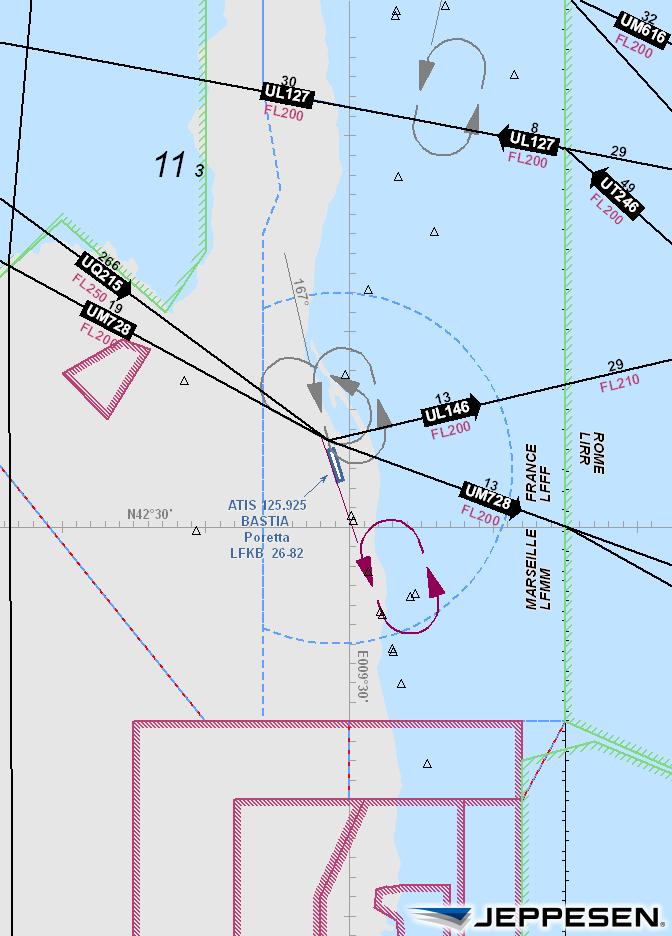
2 PORETTA 22 NOV 3 0-R.RAAR.MINIMUM.ALTITUES. Alt Set: hpa Trans level: By ATC Trans alt: 6200' The minimum altitudes published integrate a correction for low temperatures. 70 MILAN LIMM FIR MARSEILLE LFMM FIR KERIT TORTU MEGER GURPA CALNO CONTOUR INTERVALS SORI GORIT NIRO BUNAX 7600 NORKA SOUKA ILROU LIBLO 300^ Calvi 240^ AKUTI EVIRI SUAS 8878' 40 RECIF CALVI CV NB 330^ RATAP GUNPI MILNO 7000 BP NB ^ BARIL 0 CAPCO VOR ME 7800 BREMO 0^ 0 Bastia GIRAG ALISO ^ OBIM MIRSA MOULE 50^ Completely revised. 60 SOLENZARA SZA NB MARSEILLE LFMM FIR ROME LIRR FIR 50 60, 203. ALL RIGHTS RESERVE.
3 LFKB/BIA PORETTA 9 OCT Eff.5.Oct..STAR. ATIS Alt Set: hpa Trans level: By ATC Trans alt: 6200' BREMO 5N [BREM5N], LIGUR 5N MERLU 5N By ATC [LIGU5N] [MERL5N] RWY 34 ARRIVALS, MOULE 5N [MOUL5N] GEN 83^2.8 N GE LIGUR N E LIGUR 5N TORTU N E At or below FL40 AKUTI N E ^ MERLU N E ^ 2 EVIRI N E MERLU 5N MILNO N E ^ 67^ ELBA 4.7 ELB N E (IAF) 4.5 N E R290^ R327^ MAX FL00 MAX 220 KT R60^ MHA 347^ R075^ 7 ME 2 255^ MOULE 5N MOULE N E At or below FL30 5 Tracks & bearings. BREMO 5N 340^ BREMO N E , 2005, 205. ALL RIGHTS RESERVE.
4 PORETTA ATIS OCT 5 0-2A.Eff.5.Oct. Alt Set: hpa Trans level: By ATC Trans alt: 6200'.STAR. LIBLO 5N [LIBL5N] NIRO 5N[NIR5N] NORKA 5N [NORK5N] RWY 34 ARRIVALS NIRO N E At or below FL ^ 29 NIRO 5N EVIRI N E NORKA N E ^ 25^ 38 MILNO N E For flights with requested FL40 or below. NORKA 5N (IAF) 4.5 N E ^ 8 67^ R327^ R305^ R234^ MAX FL00 MAX 220 KT MHA 347^ 7 ME ELBA 4.7 ELB N E ^ LIBLO LIBLO 5N B-RNAV/RNAV 5 N42 5. E BARIL N E Tracks & bearings. 202, 205. ALL RIGHTS RESERVE.
5 PORETTA 0-2B ATIS NGE 9 OCT 5.Eff.5.Oct. Alt Set: hpa Trans level: By ATC Trans alt: 6200' BREMO 5S [BREM5S], LIGUR 5S MOULE 5S[MOUL5S] [LIGU5S].STAR. GEN 83^2.8 LIGUR N E OBIM 5S [OBI5S] By ATC RWY 6 ARRIVALS 0 9 LIGUR 5S TORTU N E At or below FL40 AKUTI N E ^ 3 CAPCO '/4800'T/FL40 inbound 93^ R-03 7/2 MAX 220 KT MAX 85 KT below FL N E N E ^ (IAF) CAPCO N E ^ 93^ R03^7 022^ MOULE 5S 2 9 R075^ (IAF by APP) ALISO N E (ELB R-287) OBIM 5S 333^ N E N E N E OBIM N E At or below FL30 293^ MOULE N E At or below FL30 MAX 250 KT ELBA 4.7 ELB N E R60^ 5 BREMO 5S 340^ BREMO N E Tracks & bearings; holding altitude., 20, 205. ALL RIGHTS RESERVE.
6 PORETTA 0-2C ATIS OCT 5.Eff.5.Oct. Alt Set: hpa Trans level: By ATC Trans alt: 6200'.STAR. LIBLO 5S [LIBL5S] NIRO 5S [NIR5S] NORKA 5S [NORK5S] RWY 6 ARRIVALS NIRO N E At or below FL200 For flights with requested FL40 or below. 099^ NORKA N E NIRO 5S 098^ 054^ LIBLO 9 NORKA 5S N42 5. E EVIRI N E ^ MILNO N E LIBLO 5S B-RNAV/RNAV 5 MAX 250 KT 2 327^ R279^ 4.5 N E N E ME Arc BARIL N E N E ^ (IAF) CAPCO N E R234^ 025^ 93^ 2 R03^7 (IAF by APP) ALISO N E ^ ELB ELB 2 N E CAPCO '/4800'T/FL40 inbound 93^ R-03 7/2 MAX 220 KT MAX 85 KT below FL70 Tracks & bearings; holding altitude., 20, 205. ALL RIGHTS RESERVE.
7 0-3 PORETTA Trans level: By ATC Trans alt: 6200' AKUTI N E MILNO N E VMC: inside TMA carry out a halfturn to land on A otherwise comply with IMC procedure. IMC: respect normalised route instruments EP to comply with set specifications and keeping assigned level until leaving the TMA. Then, comply with the FPL in force. In case of the last assigned FL is not compatible with MSA, maintain climbing to the next cruising level. 23 GEN NGE2.8 74^ 9 OCT 5.Eff.5.Oct. 03^ 50^ AJO 6N, AJO 6S AKUTI 6N [AKUT6N], AKUTI 6S RWYS 34, 6 EPARTURES.SPEE: AKUTI 6N AKUTI 6S 23 At 430' 36 MAX 250 KT BELOW FL00 23 N E ^ 2^ 8 N E ^ 9 6 CAPCO N E ^ 279^ 28 AJO 6N AJO 6S AKUTI 6S ELB 4.7 AJO 6N, 6S At or above 6200' AKUTI 6S At or above ' ELB 4.5 N E SI. [AKUT6S] AJACCIO AJO 4.8 N E AJO 6N, 6S At 430' 9 N E R03^ These SIs require minimum climb gradients of AJO 6N: 6.8% until, then 5.8% up to 8000'. AJO 6S: 7% until, then 5.4% up to 7600'. AKUTI 6N: 5.8% up to 430'. AKUTI 6S: 5.6% until. SI AJO 6N AJO 6S AKUTI 6N AKUTI 6S RWY Tracks & bearings. Gnd speed-kt 7% V/V(fpm) 6.8% V/V(fpm) 5.8% V/V(fpm) 5.6% V/V(fpm) 5.4% V/V(fpm) Initial climb clearance By ATC ROUTING Climb straight ahead to 430', turn RIGHT, intercept R-03 to 8, turn RIGHT to, R-2 to AJO. Climb straight ahead to 430', turn LEFT, intercept R-50 to 9, turn LEFT to, R-2 to AJO. Climb straight ahead to 430', turn RIGHT, intercept R-03 to 23, turn LEFT, intercept ELB R-293 to AKUTI. Climb straight ahead to 430', turn LEFT, intercept R-50 to 9, turn LEFT to, R-327 via MILNO to AKUTI. 202, 205. ALL RIGHTS RESERVE.
8 6 LFKB/BIA PORETTA 0-3A Trans level: By ATC Trans alt: 6200' 9 OCT 5.Eff.5.Oct. BREMO 6N [BREM6N] BREMO 6S [BREM6S] MOULE 6N MOULE 6S [MOUL6N] [MOUL6S] RWYS 34, 6 EPARTURES.SPEE: MAX 250 KT BELOW FL00.SI. 4.5 N E At 430' 60^ MOULE 6S Turn at 430' BREMO 6S B 369 PBP N E ^ 20^ 075^ 9 86^ BREMO 6N 030^ MOULE 6N 6 MOULE 6S 2 COMMS LOST COMMS LOST MOULE N E VMC: inside TMA carry out a halfturn to land on A otherwise comply with IMC procedure. IMC: respect normalised route instruments EP to comply with set specifications and keeping assigned level until leaving the TMA. Then, comply with the FPL in force. In case of the last assigned FL is not compatible with MSA, maintain climbing to the next cruising level. 5 SI BREMO 6N RWY 34 BREMO 6S 6 MOULE 6N 34 MOULE 6S 6 MOULE SIs revised. BREMO N E These SIs require minimum climb gradients of BREMO 6N: 5.8% up to '. BREMO 6S: 3.7% up to 430'. MOULE 6N: 5.8% up to 430'. MOULE 6S: 3.7% up to 430'. Gnd speed-kt % V/V(fpm) % V/V(fpm) Initial climb clearance By ATC ROUTING Climb straight ahead to 430', turn RIGHT, intercept 86^ bearing to BP, intercept R-60 to BREMO. Intercept R-60 to BREMO. Climb straight ahead to 430', turn RIGHT, 20^ track, intercept R-075 to MOULE. Climb straight ahead to 430', turn LEFT, 030^ track, intercept R-075 to MOULE. 202, 205. ALL RIGHTS RESERVE.
9 PORETTA 0-3B KERIT Trans level: By ATC Trans alt: 6200' N E MEGER N E At or below FL40 GEN 2.8 GNE R74^ 9 OCT 5.Eff.5.Oct. KERIT 6N [KERI6N] KERIT 6S [KERI6S] MEGER 6N [MEGE6N] MEGER 6S [MEGE6S] RWYS 34, 6 EPARTURES.SPEE: MAX 250 KT BELOW FL00.SI. GUNPI N E MEGER 6N 28 B-RNAV/RNAV N E VMC: inside TMA carry out a halfturn to land on A otherwise comply with IMC procedure. IMC: respect normalised route instruments EP to comply with set specifications and keeping assigned level until leaving the TMA. Then, comply with the FPL in force. In case of the last assigned FL is not compatible with MSA, maintain climbing to the next cruising level. 354^ MILNO N E KERIT 6S KERIT 6N MEGER 6S ^ 38^ 03^ 5 50^ 3 KERIT 6S MEGER 6S GIRAG N E CAPCO N E ^ ELB ELB 4.7 These SIs require minimum climb gradients of KERIT 6N: 5.8% up to '. MEGER 6N: 5.8% up to 430'. KERIT 6S, MEGER 6S: 5.6% until. At 430' Gnd speed-kt % V/V(fpm) N E % V/V(fpm) Initial climb clearance By ATC SI RWY ROUTING KERIT 6N 34 KERIT 6S 6 Climb straight ahead to 430', turn RIGHT, intercept R-03 to 4, turn LEFT, intercept ELB R-279, intercept R-38 to KERIT. Climb straight ahead to 430', turn LEFT, intercept R-50 to 9, turn LEFT to, R-38 to KERIT. MEGER 6N 34 Climb straight ahead to 430', turn RIGHT, intercept R-03 to GIRAG, 33^ track to MEGER. MEGER 6S 6 Climb straight ahead to 430', turn LEFT, intercept R-50 to 9, turn LEFT to, R-327 to MILNO, turn RIGHT, intercept GEN R-74 inbound via GUNPI to MEGER. For flights to LFMN, LFM, LFTZ at or below FL45. Tracks & bearings. 60^ 33^ At 6 430' 4 N E N E KERIT 6S MEGER 6S At or above ', 202, 205. ALL RIGHTS RESERVE.
10 PORETTA 0-3C SORI N E Trans level: By ATC Trans alt: 6200' NORKA N E SORI 6N, 6S 55 9 OCT 5.Eff.5.Oct. 37 NORKA 6N LIBLO 6N [LIBL6N], LIBLO 6S NORKA 6N [NORK6N] SORI 6N [SOR6N], SORI 6S [SOR6S] RWYS 34, 6 EPARTURES.SPEE: MAX 250 KT BELOW FL00.SI. [LIBL6S] 4 N E ELB ELB 279^4.7 VMC: inside TMA carry out a halfturn to land on A otherwise comply with IMC procedure. IMC: respect normalised route instruments EP to comply with set specifications and keeping assigned level until leaving the TMA. Then, comply with the FPL in force. In case of the last assigned FL is not compatible with MSA, maintain climbing to the next cruising level. LF(R)-223 LIBLO 6N, 6S At or above 7000' SORI 6N, 6S At or above ' BARIL N E ^ LIBLO 6N, 6S N42 5. E These SIs require minimum climb gradients of LIBLO 6N: 7.7% until, then 5.8% up to 200'. LIBLO 6S: 7.9% until, then Gnd speed-kt % up to 200'. NORKA 6N: 5.8% up to '. 7.9% V/V(fpm) SORI 6N: 5.8% up to 7000'. 7.7% V/V(fpm) % up to FL65 for ATS purposes. 6.2% V/V(fpm) % V/V(fpm) % up to FL85 for ATS purposes. SORI 6S: 5.6% until. 5.6% V/V(fpm) % V/V(fpm) % up to FL65 for ATS purposes. 4.8% V/V(fpm) % up to FL85 for ATS purposes. Initial climb clearance By ATC SI RWY ROUTING LIBLO 6N 34 Climb straight ahead to 430', turn RIGHT, intercept R-03 to 8, turn RIGHT to, R-234 via BARIL to LIBLO. LIBLO 6S 6 Climb straight ahead to 430', turn LEFT, intercept R-50 to 9, turn LEFT to, R-234 via BARIL to LIBLO. NORKA 6N 34 Climb straight ahead to 430', turn RIGHT, intercept R-03 to 4, turn LEFT, intercept ELB R-279 to NORKA. SORI 6N 34 Climb straight ahead to 430', turn RIGHT, intercept R-03 to 8, turn RIGHT to, R-297 to SORI. SORI 6S 6 Climb straight ahead to 430', turn LEFT, intercept R-50 to 9, turn LEFT to, R-297 to SORI. For flights to LFKJ. Tracks & bearings. LIBLO 4.5 N E N E At 430' 234^ 03^ 60^ At 430' 6 50^ 9 N E LIBLO 6N SORI 6N LIBLO 6S SORI 6S SORI 6N when area LF(R)-223 active up FL60: SORI 6N when area LF(R)-223 active up FL80: SORI 6S when area LF(R)-223 active up FL60: SORI 6S when area LF(R)-223 active up FL80:, 202, 205. ALL RIGHTS RESERVE.
11 PORETTA 0-3 Trans level: By ATC Trans alt: 6200' 9 OCT 5.Eff.5.Oct. GIRAG 6T[GIRA6T], GIRAG 6U [GIRA6U] MOULE 6T[MOUL6T], MOULE 6U[MOUL6U] RWYS 34, 6 EPARTURES TO BE USE WHEN VOR UNSERVICEABLE MAX 250 KT BELOW FL00.SPEE:.SI. irect distance from Poretta Apt to: GIRAG 27 NM MOULE 3 NM GIRAG N E COMMS LOST COMMS LOST VMC: inside TMA carry out a halfturn to land on A otherwise comply with IMC procedure. IMC: respect normalised route instruments EP to comply with set specifications and keeping assigned level until leaving the TMA. Then, comply with the FPL in force. In case of the last assigned FL is not compatible with MSA, maintain climbing to the next cruising level. At 430' GIRAG 6T 050^ 20^ 005^GIRAG 6U 075^ R255^ 85^ 030^ MOULE 6T MOULE 6U MOULE N E ELBA ELB 4.7 ELB N E At 430' SI GIRAG 6T BP 369 N E None. RWY 34 GIRAG 6U 6 MOULE 6T 34 MOULE 6U 6 These SIs require minimum climb gradients of GIRAG 6T, MOULE 6T: 5.8% up to 430'. GIRAG 6U, MOULE 6U: 3.7% up to 430'. Initial climb clearance By ATC Gnd speed-kt % V/V(fpm) % V/V(fpm) ROUTING Climb straight ahead to 430', turn RIGHT, 050^ track, intercept 005^ bearing from BP to GIRAG. Climb straight to 430', turn LEFT, intercept 005^ bearing from BP to GIRAG. Climb straight ahead to 430', turn RIGHT, 20^ track, intercept ELB R-255 inbound to MOULE. Climb straight ahead to 430', turn LEFT, 030^ track, intercept ELB R-255 inbound to MOULE., 202. ALL RIGHTS RESERVE.
12 PORETTA 0-3E Trans level: By ATC Trans alt: 6200' 9 OCT 5.Eff.5.Oct. LIBLO 6T [LIBL6T], LIBLO 6U[LIBL6U] RWYS 34, 6 EPARTURES TO BE USE WHEN VOR UNSERVICEABLE MAX 250 KT BELOW FL00.SPEE:.SI. At 6200' irect distance from Poretta Apt to: BP 8 NM At 430' At 430' 050^ LIBLO 6T 85^ 005^ LIBLO 6U COMMS LOST COMMS LOST VMC: inside TMA carry out a halfturn to land on A otherwise comply with IMC procedure. IMC: respect normalised route instruments EP to comply with set specifications and keeping assigned level until leaving the TMA. Then, comply with the FPL in force. In case of the last assigned FL is not compatible with MSA, maintain climbing to the next cruising level. LIBLO BP 369 N E N42 5. E SI LIBLO 6T LIBLO 6U RWY 6 34 RWY 34 6 MAX FL00 MAX 85 KT MHA ^ ROUTING Climb straight ahead to 430', turn RIGHT, 050^ track, intercept 005^ bearing from BP, at 6200' turn RIGHT to BP, if necessary climb in holding, turn RIGHT, 250^ bearing to LIBLO. Climb straight ahead to 430', turn LEFT, intercept 005^ bearing from BP, at 6200' turn RIGHT to BP, if necessary climb in holding, turn RIGHT, 250^ bearing to LIBLO. Holding altitude; altitude on SI LIBLO 6T. 6^ These SIs require minimum climb gradients of LIBLO 6T: 5.8% up to 7800'. LIBLO 6U: 4.5% up to 8000'. Gnd speed-kt % V/V(fpm) % V/V(fpm) Initial climb clearance By ATC RWYS 6, 34 OMNIIRECTIONAL EPARTURES ROUTING Climb to 430', then depart omnidirectional within SOUTHEAST sector between R-075 and R-50. Climb to 430', then depart omnidirectional within NORTHEAST sector between R-03 and R-075., 202, 205. ALL RIGHTS RESERVE.
13 4 EC Eff.0.ec. PORETTA N E ATIS Ground Tower ^ Elev 3' 02^E Crosswind limited to 20 KT E if rwy is wet. Parachuting NW of airport. Helicopter activity. FOR ETAILS A likely to be covered by SEE 0-9A Apron sea haze in few minutes. Wildlife strike hazard. Rwy 34 right-hand circuit. GENERAL AVIATION Apron B & C M ARP C 8268' 2520m Control Tower MET A A Apron A S S G Elev 34 Feet Meters AITIONAL RUNWAY INFORMATION USABLE LENGTHS LANING BEYON RWY Threshold Glide Slope TAKE-OFF WITH 6 HIRL (60m) REIL PAPI-L (angle 3.0^) 48' 2 34 HIRL (60m) REIL PAPI-L (angle 3.0^) RVR 7235' 2205m 45m PAPI beam offset 5^ from runway centerline. 2 TAKE-OFF RUN AVAILABLE RWY 6: RWY 34: From rwy head 8268' (2520m) From rwy head 8268' (2520m) twy E int 6873' (2095m) twy M int 520' (588m) twy M int 327' (953m) twy E int 476' (450m).Standard. TAKE-OFF LVP must be in Force A B C RCLM (AY only) or RL 250m 300m RCLM (AY only) or RL 400m Operators applying U.S. Ops Specs: CL required below 300m. Twys redesignated. Usable lengths. NIL (AY only) 500m, 999, 205. ALL RIGHTS RESERVE.
14 4 EC 5 0-9A.Eff.0.ec. PORETTA RWY 6/34 9 APRON N GA C35 C33 C36 C34 C2 C3 C25 C23 C26 C24 B5 B6B4 MET 0 C Control Tower M APRON B & C GENERAL AVIATION A8 A7 TERMINAL A6 A APRON A A5 Twy M restricted to acft with code letter C. Twy C restricted to acft with code letter B. CARGO HANGAR A4 A3 A2 A-A A-B INS COORINATES STAN No. COORINATES STAN No. COORINATES S A-A, A-B, A2 A3 thru A5 A6 thru A8 B4 thru B6 C2 thru C36 N E N E N E N E N E N E N E N E Stand B6 added., 2003, 205. ALL RIGHTS RESERVE.
15 BRIEFING STRIP TM LFKB/BIA PORETTA 2 JUN 3 -.Eff.27.Jun. ILS Z or LOC Z Rwy 34 ATIS Approach Tower Ground LOC Final GS ILS Apch Crs A BAS 4.0 BAS 6200' Refer to.35 30' (284') RWY Minimums MISSE APCH: Climb STRAIGHT AHEA. At VOR at or below 2400' turn ' RIGHT to intercept and follow R-004 climbing to '. At 7.0 0,500' turn RIGHT (MAX 85 KT) to intercept R-040 inbound VOR. At VOR turn LEFT and join holding at '. Acceleration segment not calculated. MSA VOR Alt Set: hpa Rwy Elev: hpa Trans level: By ATC Trans alt: 6200' 5^ 88^ PANS OPS Gnd speed-kts ' ' MA ILS GS or LOC escent angle 3.00^ MAP at.0 BAS/2.8.Standard. STRAIGHT-IN LANING RWY 34 A ILS LOC (GS out) A: 246'(220') C: 266'(240') CFA B: 256'(230') : 276'(250') A/MA 350'(324') A B C ' 69' 5036' 587' RVR m (IAF) B T A ' 5797' RWY For add-on to the MA, see ATC pages FRANCE. Procedure. Minimums. 67^ ^ BAS ^ RVR 48^ 400m 220^ LOC BAS ME (GS out) ALTITUE 350' 670' 990' VOR ' 3400' 4.0 BAS BAS GS30' 48^ TCH 5' RVR 300m 3947' 087' 333' 4049' 3527' BAS ' 3996' ILS ME B A S.35 BAS 4 743' LOC 30' MHA MAX 0 MAX 220 KT B 369 PBP 7.5 BAS 9.3 NB 7.5 BAS 9.3 Max Kts ' REIL PAPI-L MA 0 50' (484') ' (504') 970' (944') 40' (4') ME required ' 640' 970' 2300' MAX 200 KT ' within 8 NM. 2400' 4.5 CIRCLE-TO-LAN Prohibited West of rwy VIS 500m 600m 2400m 3600m MAX 2400', 999, 203. ALL RIGHTS RESERVE.
16 BRIEFING STRIP TM LFKB/BIA PORETTA 2 JUN 3-2.Eff.27.Jun. ILS Y or LOC Y Rwy 34 ATIS Approach Tower Ground LOC Final GS ILS Apch Crs A BAS 4.0 BAS Refer to.35 30' (284') Minimums RWY 6200' MISSE APCH: Climb STRAIGHT AHEA to 430', then turn RIGHT climbing onto 048^ to intercept and follow 005^ from NB. At 0,500' ' turn RIGHT (MAX 85 KT) climbing onto 98^ to 6200' to NB. Acceleration segment not calculated. MSA BP NB Alt Set: hpa Rwy Elev: hpa Trans level: By ATC Trans alt: 6200' 4^ PANS OPS ^ RWY MA Gnd speed-kts ILS GS or LOC esc angle 3.00^ MAP at.0 BAS STRAIGHT-IN LANING RWY A ILS A: 246'(220') C: 266'(240') B: 256'(230') : 276'(250') A/MA.Standard. A B C ' 69' 5036' 587' (IAF) B 369 PBP 048^ For add-on to the MA, see ATC pages FRANCE. Procedure. Minimums BAS BAS BAS 005^ 43^ 34 LOC (GS out) CFA 350'(324') 98^ 243^ ELB ELB 4.7 MHA 6200 MAX 0 MAX 85 KT ILS ME B A S.35 BAS 43^ Max Kts REIL PAPI-L MA 0 50' (484') ' (504') ' (944') ' (4') ME required LOC BAS ME (GS out) ALTITUE 350' 670' 990' 30' 640' 970' 2300' 2630' NB 7.5 BAS 4500' 6200' Min 6^ ' 4.0 BAS GS 2400' GS.0BAS 30' LOC 2400' TCH 5' 30' 450' 700' RVR 200m RVR 300m 4055' 5797' 087' 4049' 406' 3363' 333' 3048' 5679' 3527' 3996' 4056' 4 743' RVR 400m CIRCLE-TO-LAN Start turn at Min ' 048^ Prohibited West of rwy VIS 500m 600m 2400m 3600m ' RT, 999, 203. ALL RIGHTS RESERVE.
17 BRIEFING STRIP TM LFKB/BIA 9 OCT 5 PORETTA 3- VOR 4.5 VOR A and VPT A Rwy 6 ATIS Approach Tower Ground Final Apch Crs CAPCO 93^ ' (4974') MA Refer to Minimums MISSE APCH: Climb on R-03 inbound to VOR, then climbing turn LEFT to intercept and follow R-48, then as directed. Acceleration segment not calculated..eff.5.oct. Procedure Alt Alt Set: hpa : hpa Trans level: By ATC Trans alt: 6200' CAUTION: Obstacle clearance not assured with PAPI glide slope outside of circling area. 5^ 6200' 88^ 0,500' ' MSA VOR PANS OPS ' 22.0/R-03 to CAPCO 93^5.0 VOR (IAF) CAPCO 7.0/R CAT A & B ^ MHA (SMA 4800) MAX FL40 MAX 220 KT BELOW FL 70 MAX 85KT ' Apt CAT C & 4.5 Gnd speed-kts escent angle 3.5^ CAT A & B: MAP at 2.5 CAT C & : MAP at 3.5.Standard. 4344' 333' 4049' 4288' 3527' (IAF) ALISO 748' 48^ 93^ B T A ME ALTITUE 660' 990' 660' 2330' 2660' 3330' 3660' ' 627' N MA 9.0 A B C Max Kts ME required ' 8' 6^ 93^ 58' REIL 48^ CAPCO 03^ 7.0/R-03 PAPI-L 490' 530' 630' MA (464') (504') (604') ' 4800' 4.5 Le Golo on CIRCLE-TO-LAN 730'(704') ' within 8 NM. VPT A Rwy 6 VISUAL MANOEUVRING WITH PRESCRIBE TRACKS 2.6 CAT C & :.9 CAT A & B: 206^ 93^ 206^ ' VPT A Rwy B T A 4.5 Etang de Biguglia La Marane ^ 4.5 R-03 VIS 500m 600m 2400m 3600m Tanks ' SMA., 999, 205. ALL RIGHTS RESERVE.
18 BRIEFING STRIP TM LFKB/BIA PORETTA 3-2 VOR 4.5 MISSE APCH: Climb on R-6 inbound VOR at or below 2400', then turn RIGHT to intercept and follow R-004 climbing to '. At 7.0 turn RIGHT (MAX 85 KT) to intercept and follow R-040 inbound VOR. At VOR turn LEFT and join holding at '. VOR Rwy 34 ATIS Approach Tower Ground Final Apch Crs 9.3 Alt Set: hpa Procedure Alt A/MA (2374') 40' 2400' (384') : hpa 9 OCT 5.Eff.5.Oct. Acceleration segment not calculated. Trans level: By ATC Trans alt: 6200' 5^ 88^ 6200' 0,500' ' MSA VOR ' 5037' 087' 69' 4055' 3947' (IAF) B T A 5797' ' 3048' 3527' 67^ 333' [RW34] 3996' 2.0 [4~VOR] [7~VOR] [FS34] 4 004^ ME required. 587' MAX 200 KT 5679' ^ 48^ 220^ MHA MAX FL00 MAX 220 KT ' within 8 NM. ME ALTITUE 400' 720' 040' 350' 670' 990' 230' VOR ^ ' 2400' [7~VOR] [4~VOR] 2350' [RW34] ' [FS34] TCH 5' 720' MA Apt ^ 670' ' 480' 2.3 PANS OPS Gnd speed-kts MAX escent angle 3.00^ REIL 2400' PAPI-L on MAP at 2.0.Standard. A B C STRAIGHT-IN LANING RWY CFA A/MA 40'(384') RVR 700m 34 Max Kts 0 50' ' 40' MA (484') (504') (994') (4') 4.5 R CIRCLE-TO-LAN Prohibited West of rwy 020' VIS 700m 700m 2400m 3600m None., 999, 202. ALL RIGHTS RESERVE.
19 BRIEFING STRIP TM LFKB/BIA 2 JUN 3 PORETTA NB Final Minimum Alt A/MA BP Apch Crs NB ' (2374') 050'(024') MISSE APCH: Turn RIGHT climbing to intercept and follow 002^ 0,500' from NB to ', then turn RIGHT (MAX 85 KT) onto 98^ to NB climbing to 6200'. Acceleration segment not calculated. Alt Set: hpa Eff.27.Jun. NB Rwy 34 ATIS Approach Tower Ground 087' 3527' : hpa Trans level: By ATC Trans alt: 6200' 4^ 6200' MSA BP NB PANS OPS TCH 5' [MN23] (IAF) B 369 PBP [MN23] ^ 0 Gnd speed-kts escent angle 3.00^ NB to MAP 5.0 4:7 3:20 3:00 2:30 2:09 :53.Standard. B T A 4.5 6^ 002^ 34 CFA 050'(024') MA 5.0 For add-on to the MA, see ATC pages FRANCE. 6^ 296^ 98^ MHA 6200 MAX 0 MAX 85 KT 388' A B C 4055' 5797' 4049' APT None. 333' 3996' Min STRAIGHT-IN LANING RWY A/MA RVR 500m CMV 743' 4500' 2400m 6^ 4500' 3.00^ NB 6200' 7.3 MAX 85 KT 6^ 2400' Max Kts MA REIL PAPI-L CIRCLE-TO-LAN Prohibited West of rwy 050' (024') 050' (024') 050' (024') 260'(234') ' RECOMMENE ALTITUES IST to MN23 ALTITUE ' ' ' '.0 20' Refer to Missed Apch above VIS 500m 600m 2400m 3600m, 999, 202. ALL RIGHTS RESERVE.
20 N 93 LFKB/BIA 2 JUN '.Eff.27.Jun. PORETTA VPT B Rwy 6 VISUAL MANOEUVRING WITH PRESCRIBE TRACKS 2638' ' Etang de Biguglia MAX 80 KT 2736' 6^.0 CAT C & : 2874' 3455' 3780' N 93 B T A ' 8' le Golo 58' ILS ME B A S.35 BAS BAS 3.5 CAT A & B: 05^.7 BAS 05^ Tanks La Marane CAT A & B: 2.3 CAT C & : Use BAS ME information after ILS Y apch. 386' 3996' 500 N ' 3327' ' CAUTION: Obstacle clearance not assured with PAPI glide slope outside of circling area..standard. Procedure prohibited after NB apch A B C Max Kts ' 530' 630' 730' MA (464') (504') (604') (704') VIS 500m 600m 2400m 3600m Procedure., 999, 203. ALL RIGHTS RESERVE.
21
Airport Information. Details for IFAISTOS. State/Province
 Airport Information etails for City State/Province Country GRC Latitude N 39 55' 02.00" Longitude E 25 14' 11.00" Elevation 14 Longest Runway 9800 Magnetic Variance E 2.0 Fuel Type JET A-1 fuel is available
Airport Information. Details for KING PYRROS. State/Province
 Airport Information etails for City State/Province Country GRC Latitude N 39 4' 50.00" Longitude E 20 49' 9.00" Elevation 55 Longest Runway 700 Magnetic Variance E Fuel Type JET A- fuel is available Oxygen
Airport Information. Details for ARISTARCHOS OF SAMOS. State/Province
 Airport Information etails for ARISTARCHOS OF City State/Province Country GRC Latitude N 37 4' 2.00" Longitude E 26 54' 44.00" Elevation 9 Longest Runway 6700 Magnetic Variance E 4.0 Fuel Type 00 Low Lead
JeppView for Windows. jep=jeppesen. Airport Information For LGKF Printed on 11 Dec 2017 Page 1. General Information. Runway Information
 Airport Information For LGKF Printed on 11 ec 017 Page 1 (c) SANERSON, INC., 017, ALL RIGHTS RESERVE jep= JeppView for Windows General Information Location: GRC ICAO/IATA: LGKF / EFL Lat/Long: N38 07.0',
Minor engine repairs are available.
 Airport Information etails for City VLAIVOSTOK State/Province Country RUS Latitude N 43 23' 53.00" Longitude E 32 08' 56.00" Elevation 59 Longest Runway 400 Magnetic Variance W 0.0 Fuel Type JET A- fuel
KPL N E LMO N E LGLM/LXS CHRISOUPOLIS ONE CHARLIE (KPL 1C) KOROS ONE CHARLIE RWYS 04R, 22L ARRIVALS .STAR.
 KOROS ONE CHARLIE RWYS 04R, 22L ARRIVALS .STAR.") 10-2 (T) CHRISOUPOLIS KPL 108.8 N40 54.8 E024 36.9 153^ 40 KPL 1C Alt Set: hpa Trans level: By ATC Trans alt: ' CHRISOUPOLIS ONE CHARLIE (KPL 1C) KOROS ONE CHARLIE (KOROS 1C) [KORO1C] RWYS 04R, 22L ARRIVALS,
10-2 (T) CHRISOUPOLIS KPL 108.8 N40 54.8 E024 36.9 153^ 40 KPL 1C Alt Set: hpa Trans level: By ATC Trans alt: ' CHRISOUPOLIS ONE CHARLIE (KPL 1C) KOROS ONE CHARLIE (KOROS 1C) [KORO1C] RWYS 04R, 22L ARRIVALS,
Airport Information. Details for TURKMENBASHI. Terminal Chart Change Notices. TURKMENBASHI State/Province
 Airport Information etails for City State/Province Country TKM Latitude N 40 03' 48.00" Longitude E 53 00'.00" Elevation 283 Longest Runway 11400 Magnetic Variance E 5.0 Fuel Type JET A-1 fuel is available
JeppView for Windows. General Information. Runway Information. Communication Information. jep=jeppesen
 Airport Information For UBBG Printed on 27 Jan 2018 Page 1 (c) SANERSON, INC., 2018, ALL RIGHTS RESERVE jep= JeppView for Windows General Information Location: AZE ICAO/IATA: UBBG / KV Lat/Long: N40 44.33',
JeppView for Windows. jep=jeppesen. Airport Information For LGMK Printed on 11 Dec 2017 Page 1. General Information. Runway Information
 Airport Information For LGMK Printed on 11 ec 2017 Page 1 (c) SANERSON, INC., 2017, ALL RIGHTS RESERVE jep= JeppView for Windows General Information Location: GRC ICAO/IATA: LGMK / JMK Lat/Long: N37 26.23',
Major engine repairs are available.
 Airport Information etails for City State/Province Country FRA Latitude N 4 44' 7.00" Longitude E 5'.00" Elevation 44 Longest Runway 800 Magnetic Variance E 0.0 Fuel Type 00 Low Lead (LL) octane fuel is
LUKK/KIV .STAR KIV [ABLI3A] [ANED3A] [ABLI3E] [ANED3E] ANEDO ABLIK NOT FOR OPERATIONAL USE CHISINAU ANEDO 3A CHISINAU INTL
![LUKK/KIV .STAR KIV [ABLI3A] [ANED3A] [ABLI3E] [ANED3E] ANEDO ABLIK NOT FOR OPERATIONAL USE CHISINAU ANEDO 3A CHISINAU INTL](/thumbs/81/83199631.jpg "LUKK/KIV .STAR KIV [ABLI3A] [ANED3A] [ABLI3E] [ANED3E] ANEDO ABLIK NOT FOR OPERATIONAL USE CHISINAU ANEDO 3A CHISINAU INTL") , MOLOVA LUKK/KIV INTL 6 MAR 09 10-2.Eff.12.Mar..STAR. ATIS Alt Set: hpa 125.22 399' Trans level: By ATC Trans alt: ' 24 R125^ 20 R230^ 15.4 181^ ABLIK N46 30.8 E028 37.6 GOTIK (IAF Rwy ) NATIV N46 40.1
, MOLOVA LUKK/KIV INTL 6 MAR 09 10-2.Eff.12.Mar..STAR. ATIS Alt Set: hpa 125.22 399' Trans level: By ATC Trans alt: ' 24 R125^ 20 R230^ 15.4 181^ ABLIK N46 30.8 E028 37.6 GOTIK (IAF Rwy ) NATIV N46 40.1
JeppView for Windows. List of pages in this Trip Kit. Trip Kit Index
 Trip Kit Index Printed on 06 Jan 2014 Page 1 (c) SANERSON, INC., 2014, ALL RIGHTS RESERVE jep= JeppView for Windows List of pages in this Trip Kit Trip Kit Index Airport Information For U Terminal Charts
JEPPESEN 10-2.STAR. 16 JUL 10.Eff.29.Jul.
 , RUSSIA 102.STAR. *ATIS Apt Elev Alt set: MM (hpa on request) QNH on request (QFE) 126.9 1688' Trans level: Trans alt: IENI 1A [IEN1A] OSKEN 1A [OSKE1A] USONA 1A [USON1A] RWY 12 ARRIVALS FROM EAST & SOUTH
Airport Information. Details for ZARAGOZA. State/Province
 Airport Information etails for City State/Province Country ESP Latitude N 4 39' 58.00" Longitude W 02' 30.00" Elevation 863 Longest Runway 200 Magnetic Variance W.0 Fuel Type 00 Low Lead (LL) octane fuel
JEPPESEN FliteMap
 REVISION LETTER For isc 09206 Licensed to r. Gyorgy Hajos. Printed on 30 Apr 206. Page Changed chart(s) since isc 08206 A = Added chart, REV = Revised chart, EL = eleted chart. ACT PROCEURE IENT INEX REV
JeppView for Windows. Communication Information. Runway Information. jep=jeppesen
 Airport Information For LIRP Printed on ec 27 Page (c) SANERSON, INC., 27, ALL RIGHTS RESERVE jep= JeppView for Windows Lighting: General Edge, Information Centerline Communication Information Location:
Airport Information. Details for DEBRECEN. State/Province
 irport Information etails for ity State/Province ountry HUN Latitude N 47 29' 20.00" Longitude E 2 36' 55.00" Elevation 359 Longest Runway 8200 Magnetic Variance E 4.0 Fuel Type 00 Low Lead (LL) octane
Major engine repairs are available.
 irport Information etails for TVUX ity LE State/Province ountry FR Latitude N 47 0' 34.00" Longitude E 5 6' 06.00" Elevation 645 Longest Runway 7300 Magnetic Variance E 0.0 Fuel Type 00 Low Lead (LL) octane
JeppView for Windows. Runway Information. Communication Information. jep=jeppesen
 Airport Information For UIII Printed on 27 Jan 208 Page (c) SANERSON, INC., 208, ALL RIGHTS RESERVE jep= JeppView for Windows Irkutsk General Radar: Information 9.300 Irkutsk Transit Operations: 3.700
JeppView for Windows. List of pages in this Trip Kit. jep=jeppesen. Trip Kit Index
 Trip Kit Index Printed on 22 Dec 208 Page (c) SANDERSON, INC., 208, ALL RIGHTS RESERVED jep= JeppView for Windows List of pages in this Trip Kit Trip Kit Index Airport Information For UKLR Terminal Charts
JeppView for Windows. jep=jeppesen. Airport Information For EPPO Printed on 06 Dec 2017 Page 1. General Information. Runway Information
 Airport Information For EPPO Printed on 06 ec 207 Page (c) SANERSON, INC., 207, ALL RIGHTS RESERVE jep= JeppView for Windows General Information Location: POL ICAO/IATA: EPPO / POZ Lat/Long: N52 25.27',
Airport Information. Details for MAUPERTUS. Terminal Chart Change Notices. State/Province
 irport Information Details for MUPERTUS ity HEROURG State/Province ountry FR Latitude N 49 39' 03.00" Longitude W ' 3.00" Elevation 459 Longest Runway 8000 Magnetic Variance W 3.0 Fuel Type 00 Low Lead
TASHKENT, UZBEKISTAN UTTT/TAS ISLAM KARIMOV 1.1. ATIS SPEED RESTRICTION MAX 250 KT below FL 100 or as by ATC LOW VISIBILITY PROCEDURES
 .. ATIS ATIS 26.8 +.2. SPEE RESTRICTION MAX 20 KT below FL 00 or as by ATC..3. LOW VISIBILITY PROCEURES.3.. GENERAL LVP will be used if visibility is - 400m or less at NIGHT; - 800m orless at AY. 23 MAR
JeppView for Windows. List of pages in this Trip Kit. Trip Kit Index
 Trip Kit Index Printed on 4 Jan 207 Page (c) SANDERSON, INC., 207, ALL RIGHTS RESERVED jep= JeppView for Windows List of pages in this Trip Kit Trip Kit Index Airport Information For UWKB Terminal Charts
JeppView for Windows. General Information. Runway Information. Communication Information. jep=jeppesen
 irport Information For UN Printed on 27 Jan 208 Page (c) SNERSON, INC., 208, LL RIGHTS RESERVE jep= JeppView for Windows General Information Location: RUS ICO/IT: UN / B Lat/Long: N53 44.40', E09 23.2'
JeppView for Windows. General Information. Runway Information. Communication Information. jep=jeppesen
 Airport Information For LUKK Printed on ec 207 Page (c) SANERSON, INC., 207, ALL RIGHTS RESERVE jep= JeppView for Windows General Information Location: MA ICAO/IATA: LUKK / KIV Lat/Long: N46 55.67', E028
Airport Information. Details for ASHGABAT. Terminal Chart Change Notices. State/Province
 irport Information etails for ity State/Province ountry TKM Latitude N 37 59' 30.00" Longitude E 58 21' 43.00" Elevation 692 Longest Runway 12400 Magnetic Variance E 4.0 Fuel Type JET -1 fuel is available
JeppView for Windows. General Information. Runway Information. Communication Information. jep=jeppesen
 irport Information For LWOH Printed on 27 Jan 2018 Page 1 (c) SNERSON, IN., 2018, LL RIGHTS RESERVE jep= JeppView for Windows General Information Location: I MK IO/IT: LWOH / OH Lat/Long: N41 10.80', E020
FSHolland Bijeenkomst 2 september 2017 Vlucht 3 IFR LEMH (Menorca) to LEAL (Alicante-Elche)
 to LEAL (Alicante-Elche)") FSHolland Bijeenkomst 2 september 207 Vlucht 3 IFR LEMH (Menorca) to LEL (licante-elche) You created this PF from an application that is not licensed to print to novapf printer (http://www.novapdf.com)
FSHolland Bijeenkomst 2 september 207 Vlucht 3 IFR LEMH (Menorca) to LEL (licante-elche) You created this PF from an application that is not licensed to print to novapf printer (http://www.novapdf.com)
ST PETERSBURG, RUSSIA
 ULLI/LE.. ATIS ATIS 27.3 27.4 (Russian) + 5 JUN 2 0-P.Eff.28.Jun.. GENERAL.AIRPORT.BRIEFING..2. LOW IBILITY PROCEURES.2.. GENERAL Low visibility procedures shall be applied when is 000m or less and/or
JEPPESEN. This chart should only be used for cross-checking of assigned altitudes while under radar control. OP(P)-249A D30 D25 R005^ D20 D10
-249A D30 D25 R005^ D20 D10") OP/IS 668' 9 MAR 2 0-R ISLAMAA, PAKISTAN.RAAR.MINIMUM.ALTITUES. Alt Set: hpa (IN on request) Trans level: FL40 Trans alt: 2000' This chart should only be used for cross-checking of assigned altitudes while
OP/IS 668' 9 MAR 2 0-R ISLAMAA, PAKISTAN.RAAR.MINIMUM.ALTITUES. Alt Set: hpa (IN on request) Trans level: FL40 Trans alt: 2000' This chart should only be used for cross-checking of assigned altitudes while
JeppView for Windows. ep=jeppesen. jj je ee j. Trip Kit Index. Printed on 16 Sep 2016 Page 1. List of pages in this Trip Kit.
 jj je ee j Trip Kit Index Printed on 16 Sep 2016 Page 1 (c) SANERSON, INC., 2016, ALL RIGHTS RESERVE ep= JeppView for Windows List of pages in this Trip Kit Trip Kit Index Airport Information For UMMS
Airport Information. Details for LOMBOK INTL. State/Province
 irport Information etails for ity State/Province ountry IN Latitude S 8 45' 27.00" Longitude E 116 16' 36.00" Elevation 319 Longest Runway 9000 Magnetic Variance E 2.0 Fuel Type JET -1 fuel is available
JeppView for Windows. General Information. Runway Information. Communication Information. jep=jeppesen
 irport Information For ULMM Printed on 27 Jan 208 Page (c) SNDERSON, INC., 208, LL RIGHTS RESERVED jep= JeppView for Windows General Information Location: RUS ICO/IT: ULMM / MMK Lat/Long: N68 46.90', E032
JeppView for Windows. jep=jeppesen. Airport Information For EINN Printed on 06 Dec 2017 Page 1. General Information. Runway Information
 Airport Information For EINN Printed on 06 ec 2017 Page 1 (c) SANERSON, INC., 2017, ALL RIGHTS RESERVE jep= JeppView for Windows General Information Location: IRL ICAO/IATA: EINN / SNN Lat/Long: N52 42.12',
JEPPESEN FliteMap
 REVISION LETTER For isc 03-205 Licensed to TEST. Printed on 0 Feb 205. Page Changed chart(s) since isc 02-205 A = Added chart, REV = Revised chart, EL = eleted chart. ACT PROCEURE IENT INEX REV ATE EFF
JeppView for Windows. jep=jeppesen. Airport Information For LFLS Printed on 06 Dec 2017 Page 1. General Information. Runway Information
 Airport Information For LFLS Printed on 06 ec 207 Page (c) SANERSON, INC., 207, ALL RIGHTS RESERVE jep= JeppView for Windows General Information Location: GRENOBLE FRA ICAO/IATA: LFLS / GNB Lat/Long: N45
Airport Information. Details for ISLAMABAD INTL. Terminal Chart Change Notices. State/Province
 Airport Information etails for ISLAMABA INTL ity ISLAMABA State/Province ountry PAK Latitude N 33 32' 56.70" Longitude E 72 49' 32.34" Elevation 1761 Longest Runway 12000 Magnetic Variance E 2.0 Fuel Type
Airport Information. Details for ST CATHERINE. Terminal Chart Change Notices. State/Province
 irport Information etails for ST THERINE ity LVI State/Province ountry FR Latitude N 42 3' 28.00" Longitude E 8 47' 35.00" Elevation 20 Longest Runway 7500 Magnetic Variance E 2.0 Fuel Type 00 Low Lead
JeppView for Windows. General Information. Runway Information. Communication Information. jep=jeppesen
 Airport Information For LPFR Printed on ec 207 Page (c) SANERSON, INC., 207, ALL RIGHTS RESERVE jep= JeppView for Windows General Information Location: PRT ICAO/IATA: LPFR / FAO Lat/Long: N37 00.87', W007
JeppView for Windows. jep=jeppesen. Airport Information For EPRA Printed on 06 Dec 2017 Page 1. General Information. Runway Information
 irport Information For EPR Printed on 06 ec 2017 Page 1 (c) SNERSON, IN., 2017, LL RIGHTS RESERVE jep= JeppView for Windows General Information Location: ROM POL IO/IT: EPR / RO Lat/Long: N51 23.33', E021
General Info Stornoway, GBR N ' W ' Mag Var: 7.9 W Elevation: 26'
 irport Information EGPO (tornoway) General Info tornoway, GR N 58.9' W 06 9.9' Mag Var: 7.9 W Elevation: 6' Public, ontrol Tower, IFR, Landing Fee, ustoms availble on a restrcted basis Fuel: 00LL, Jet
JeppView for Windows. General Information. Runway Information. Communication Information. jep=jeppesen
 irport Information For ESOW Printed on 27 Jan 208 Page (c) SNERSON, IN., 208, LL RIGHTS RESERVE jep= JeppView for Windows General Information Location: STOKHOLM SWE IO/IT: ESOW / VST Lat/Long: N59 35.37',
JEPPESEN. 21 JUN B.Eff.27.Jun. Alt Set: hpa Trans level: By ATC Trans alt: 6000' VIC 3A RWYS 04L/R TRANSITIONS. By ATC VICENZA 113.
 LIPZ/VE pt Elev 21 JUN 13 10-2B.Eff.27.Jun. lt Set: hpa Trans level: By T Trans alt: 6000' LBET 4 [LB4], HI 3 VI 3 RWYS 04L/R TRNSITIONS RNV (RNV 1 REOENE) OR ONVENTIONL BY T.TRNSITION. 7200' 100^1 200^
JeppView for Windows. General Information. Runway Information. Communication Information. jep=jeppesen
 Airport Information For ENTC Printed on 27 Jan 2018 Page 1 (c) SANERSON, INC., 2018, ALL RIGHTS RESERVE jep= JeppView for Windows General Information Location: TROMSO NOR ICAO/IATA: ENTC / TOS Lat/Long:
Airport Information. Details for ISLAMABAD INTL. Terminal Chart Change Notices. State/Province
 Airport Information etails for ISLAMABA INTL ity ISLAMABA State/Province ountry PAK Latitude N 33 32' 56.70" Longitude E 72 49' 32.34" Elevation 1761 Longest Runway 12000 Magnetic Variance E 2.0 Fuel Type
Airport Information. Details for ISLAMABAD INTL. Terminal Chart Change Notices. State/Province
 Airport Information etails for INTL ity State/Province ountry PAK Latitude N 33 32' 56.70" Longitude E 72 49' 32.34" Elevation 1761 Longest Runway 12000 Magnetic Variance E 2.0 Fuel Type JET A-1 fuel is
JeppView for Windows. jep=jeppesen. Airport Information For LEGE Printed on 06 Dec 2017 Page 1. General Information. Runway Information
 Airport Information For LEGE Printed on 6 ec 27 Page (c) SANERSON, IN., 27, ALL RIGHTS RESERVE jep= JeppView for Windows General Information Location: ONA ESP IAO/IATA: LEGE / GRO Lat/Long: N4 54.5', E2
1. GENERAL 2. ARRIVAL COMMUNICATION FAILURE PROCEDURES At or above 9000' QNH: - if in VMC, continue flight in VMC;
 , 2015, 2016. ALL RIGHTS RESERVE. + 1.1. ATIS ATIS 126.8 1.2. OTHER INFORMATION Large solitary predatory birds. RWY 26R right-hand circuit. 2.1. COMMUNICATION FAILURE PROCEURES 9000' QNH: - if in VMC,
General Information. Runway Information. Communication Information
 je General Information Location: CHICHEN-ITZ MEX ICO/IT: MMCT / Lat/Long: N20 38.5', W088 26.8' Elevation: 02 ft irport Use: Public aylight Savings: Observed UTC Conversion: +6:00 = UTC Magnetic Variation:.0
JeppView for Windows. General Information. Runway Information. Communication Information. jep=jeppesen
 irport Information For USRO Printed on 27 Jan 208 Page (c) SNDERSON, INC., 208, LL RIGHTS RESERVED jep= JeppView for Windows General Information Location: RUS ICO/IT: USRO / NOJ Lat/Long: N63.03', E075
General Info Krabi, THA N ' E ' Mag Var: 0.0 W Elevation: 93' Runway Info Runway ' x 148' asphalt
 irport Information VTSG (Krabi) General Info Krabi, TH N 08 05.8' E 98 59.3' Mag Var: 0.0 W Elevation: Public, ontrol Tower, IFR, No Fee, Rotating eacon, ustoms availble on a restrcted basis Time Zone
JeppView for Windows. General Information. Runway Information. Communication Information. jep=jeppesen
 irport Information For EKRN Printed on 7 Jan 08 Page (c) SNERSON, IN., 08, LL RIGHTS RESERVE jep= JeppView for Windows General Information Location: ORNHOLM NK IO/IT: EKRN / RNN Lat/Long: N55 03.80', E04
1-10. GENERAL Operational Hours
 Effective_5-JAN-17 9-EC-1 1-1 Turkey Burs Yeniseir AOI AOI ATS Hours / A AMIN Hours: H GENERAL Opertionl Hours Airport Informtion RFF: CAT Fuel: JP- PCN: RWY 7L/5R: 11/R/C/W/T LCN: RWY 7R/5L: 5 Customs:
General Information. Runway Information. Communication Information
 irport Information For MMSL Printed on 11 pr 2018 Page 1 (c) SNERSON, INC., 2018, LL RIGHTS RESERVE p= je General Information Location: CO SN LUCS MEX ICO: MMSL Lat/Long: N22 56.9', W109 56.3' Elevation:
JeppView for Windows. Trip Kit Index. Printed on 13 Jan 2016 Page 1. List of pages in this Trip Kit. Trip Kit Index
 Trip Kit Index Printed on 3 Jan 206 Page (c) SANERSON, INC., 206, ALL RIGHTS RESERVE jep= JeppView for Windows List of pages in this Trip Kit Trip Kit Index Airport Information For IAP Terminal Charts
KUWAIT, KUWAIT OKBK/KWI KFR VOR DME KUA VOR DME WAFRA KUWAIT
 4 SEP 07 Radar FOR SIMULATOR USE ONLY 0-R.Eff.27.Sep..RAAR.MINIMUM.ALTITUES. Radar (APP) 25.3 2.3 Apt Elev Trans level: FL50 Trans alt: ' This chart may only be used for cross-checking of altitudes assigned
JeppView for Windows. General Information. Runway Information. Communication Information. jep=jeppesen
 irport Information For ESKM Printed on 27 Jan 208 Page (c) SNERSON, IN., 208, LL RIGHTS RESERVE jep= JeppView for Windows General Information Location: MOR SWE IO/IT: ESKM / MXX Lat/Long: N60 57.52', E04
JeppView for Windows. General Information. Runway Information. Communication Information. jep=jeppesen
 irport Information For G Printed on 27 Jan 208 Page (c) SNERSON, INC., 208, LL RIGHTS RESERVE jep= JeppView for Windows General Information Location: CCR GH ICO/IT: G / CC Lat/Long: N05 36.26', W000 0.05'
LMS SAN PEDRO SULA, HONDURAS MHLM/SAP RADAR 3000' 7000' 5500' 9500' 4000' 10000' 7000' 7000' 11000' 8000' 4000' 8000' LA MESA KORTI OMOSO RUBRA BATAN
 NOTIE: PRINTE FROM N EXPIRE REVISION. isc 09-2013 RMON VILLE MORLES INTL * pproach (R) 119.7 22 JUN 12 10-1R.RR.MINIMUM.LTITUES. lt Set: hpa SN PERO SUL, HONURS Trans level: FL 200 Trans alt: 19 10 0 10
Climb to 6000' DM E (111.5) INWC (111.5) INC INC NEWCASTLE ILS DME. Climb to 320' ' 266' ADDITIONAL RUNWAY INFORMATION
 INWC (111.5) INC INC NEWCASTLE ILS DME. Climb to 320' ' 266' ADDITIONAL RUNWAY INFORMATION") E/NL MY 06 0-.EPRTURE. pt Elev 66' Trans level: y T Trans alt: 6000' epartures are also noise preferential routes., UK limb to 6000' ILS ME (.5) (.5) INW N5. W00 4. N5. W00 4. limb to 6000' IRETION Track
E/NL MY 06 0-.EPRTURE. pt Elev 66' Trans level: y T Trans alt: 6000' epartures are also noise preferential routes., UK limb to 6000' ILS ME (.5) (.5) INW N5. W00 4. N5. W00 4. limb to 6000' IRETION Track
JeppView for Windows. jep=jeppesen. Airport Information For HTZA Printed on 06 Dec 2017 Page 1. General Information. Runway Information
 irport Information For HTZ Printed on 06 ec 2017 Page 1 (c) SNERSON, IN., 2017, LL RIGHTS RESERVE jep= JeppView for Windows General Information Location: ZNZIR TZ IO/IT: HTZ / ZNZ Lat/Long: S06 13.49',
JEPPESEN JeppView
 REVISION LETTER For isc 23-07 Page hanged chart(s) since isc 22-07 = dded chart, REV = Revised chart, EL = eleted chart. T PROEURE IENT INEX REV TE EFF TE Monterrey, (el Norte Intl - MMN) ONON EP -3 6
Serbia and Montenegro vacc Aerodrome Charts - Nis [LYNI]
![Serbia and Montenegro vacc Aerodrome Charts - Nis [LYNI]](/thumbs/94/120315345.jpg "Serbia and Montenegro vacc Aerodrome Charts - Nis [LYNI]") Serbia and Montenegro v erodrome harts - Nis [LYNI] isclaimer: These charts are intended for flight simulation purposes, and should not, under any circumstances, be used for real aviation navigation. Serbia
Serbia and Montenegro v erodrome harts - Nis [LYNI] isclaimer: These charts are intended for flight simulation purposes, and should not, under any circumstances, be used for real aviation navigation. Serbia
No valido para navegacion real
 HNGES: onstruction area, parking spots. SNR pt Elev 920' S27 29.8 W064 56.2 TERMS E RIO HONO, RGENTIN TERMS E RIO HONO Tower TERMS E RIO HONO *119.85 64-57 64-56 27-29 27-29 19 189^ Elev 920' 07^W 8202'2500m
CAT ' MON-THU , FRI CAT
 LPBJ Airport information: Country: Portugal City: A Coordinates: N 38 04.7', W 007 56.0' Elevation: 636 Customs: Nil Fuel: Not avbl RFF: CAT 8 MON-THU 0830-1715, FRI 0830-10. CAT 7 other times hours: MON-THU:
DTNH (Hammamet) JeppView General Info Enfidha, TUN N ' E ' Mag Var: 0.0 W Elevation: 21' Runway Info. Communications Info
 JeppView General Info Enfidha, TUN N ' E ' Mag Var: 0.0 W Elevation: 21' Runway Info. Communications Info") irport Information TNH (Hammamet) JeppView 3.6.2.0 General Info Enfidha, TUN N 36 04.5' E 0 26.3' Mag Var: 0.0 W Elevation: 2' Public, IFR, Rotating Beacon, Customs Fuel: Jet - Time Zone Info: GMT+:00
irport Information TNH (Hammamet) JeppView 3.6.2.0 General Info Enfidha, TUN N 36 04.5' E 0 26.3' Mag Var: 0.0 W Elevation: 2' Public, IFR, Rotating Beacon, Customs Fuel: Jet - Time Zone Info: GMT+:00
JeppView for Windows. List of pages in this Trip Kit. Trip Kit Index
 Trip Kit Index Printed on 14 Jan 2017 Page 1 (c) SANERSON, INC., 2017, ALL RIGHTS RESERVE jep= JeppView for Windows List of pages in this Trip Kit Trip Kit Index Airport Information For LEVC Terminal Charts
General Info Nizhny Novgorod, RUS N ' E ' Mag Var: 10.5 E Elevation: 256'
 irport Information UWGG (Strigino) JeppView... General Info Nizhny Novgorod, RUS N 5.8' E 4 47.0' Mag Var: 0.5 E Elevation: 5' Public, IFR, ontrol Tower, ustoms Fuel: Jet Repairs: Minor irframe, Minor
General Information. Runway Information. Communication Information
 irport Information For MMZH Printed on 11 pr 2018 Page 1 (c) SNERSON, INC., 2018, LL RIGHTS RESERVE p= je General Information Location: IXTP-UTNEJO MEX ICO/IT: MMZH / Lat/Long: N17 36.1', W101 27.6' Elevation:
BURGAS BGS 9.7 DME. OMORI 1B On BGS R-104 inbound to BGS, descending to. SUNIB 1D On BGS R-028 inbound to BGS. L 622
 pt Elev lt Set: hpa 0.95 5' Transition level: y T, ULGRI MY 09 0.Eff.7.May..STR. 9.5 ESEN N4 0.6 E06 5.4 N4 4. E07. OMORI N4 7.0 E08 0.0 8^ OMORI 84^ R08^ SUNI 08^ R^ R058^ 0^ ESEN 4.8 R0^ 4080' 0m 00m
JeppView for Windows. List of pages in this Trip Kit. jep=jeppesen. Trip Kit Index
 Trip Kit Index Printed on 28 Jun 2015 Page 1 (c) SNERSON, IN., 2015, LL RIGHTS RESERVE jep= JeppView for Windows List of pages in this Trip Kit Trip Kit Index irport Information For TTP Terminal harts
KIS LVA 310 N E LAVAN 3A, LAVAN 3B, LAVAN 3C LENGEH 4A, LENGEH 3B, LENGEH 4C ORSAR 1A, ORSAR 1B, ORSAR 1C ARRIVALS .STAR. 114.
 16 32 26 *TIS TRNS LEVEL: Y T TRNS LT: ' 16 FE 01 N26 32.2 E054 51.1 NR LENGEH 114.8 LEN.STR. 10-2.Eff.25.Jan. ISLN, IRN LVN 3, LVN 3, LVN 3 LENGEH 4, LENGEH 3, LENGEH 4 ORSR 1, ORSR 1, ORSR 1 RRIVLS 268^
No valido para navegacion real
 SZ/HI OMNNTE ESPOR NS pt Elev Trans level: y T Trans alt: When aircraft are holding over, departing aircraft cannot exceed before 0 ME. KNOS EPRTURE [KNOS] (RWYS 7L/35R) HI LN, RGENTIN.SI. MS KNOS S38
AD CHART RJTH / HACHIJOJIMA HACHIJOJIMA AIRPORT. AIP Japan HACHIJOJIMA RJTH-AD LONGITUDINAL PROFILE OF RUNWAY. (86.5m) 284ft 0.71% (87.4m) 0.
 284ft 0.71% (87.4m) 0.") RJTH-AD2-24.1 RJTH / AD CHART TRUE NORTH AIRPORT ABN APRON FLOOD LIGHTS RADIO OVERRUN AREA EDGE LGT 324.3m 1 2 3 RTHL ARP PAPI Angle 3.0 MEHT 18.5m(61ft) WDI WDI 26 08 CLOSED MARKINGS RWY THR ID LGT 322.6m
RJTH-AD2-24.1 RJTH / AD CHART TRUE NORTH AIRPORT ABN APRON FLOOD LIGHTS RADIO OVERRUN AREA EDGE LGT 324.3m 1 2 3 RTHL ARP PAPI Angle 3.0 MEHT 18.5m(61ft) WDI WDI 26 08 CLOSED MARKINGS RWY THR ID LGT 322.6m
JEPPESEN. Alt Set: hpa Trans level: FL200 Trans alt: 19500' 1. GPS required. 2. RNP RADAR required. 4. DME/DME not required.
 HNGES: TIS frequency, Navdata identifier added., 2008, 20. LL RIGHTS RESERVE. NOTIE: PRINTE FROM N EXPIRE REVISION. isc 09-203 pt Elev 25 NOV 0-2 lt Set: hpa Trans level: FL200 Trans alt: 9500'. GPS required.
Runway Information. Communication Information. Information: Mazatlan ACC:
 irport Information For MMML Printed on 24 Jul 208 Page (c) SNERSON, IN., 208, LL RIGHTS RESERVE p= je Mexicali General Information: 22.300 Mazatlan : 28.300 Location: MEX IO/IT: MMML / Lat/Long: N32 37.8',
JeppView for Windows. JeppView for Windows. jep=jeppesen. jep=jeppesen. Trip Kit Index. Airport Information For EFKT
 Trip Kit Index Printed on 3 Jul 8 Page (c) SNERSON, IN., 8, LL RIGHTS RESERVE jep= JeppView for Windows irport Information For EFKT Printed on 3 Jul 8 Page (c) SNERSON, IN., 8, LL RIGHTS RESERVE jep= JeppView
JeppView for Windows. General Information. Runway Information. Communication Information. jep=jeppesen
 irport Information For SVM Printed on 22 Jul 2018 Page 1 (c) SNERSON, IN., 2018, LL RIGHTS RESERVE jep= JeppView for Windows General Information arquisimeto pproach: 119.400 arquisimeto Radio: 132.000
General Information. Runway Information. Communication Information
 irport Information For MMZ Printed on pr 208 Page (c) SNERSON, IN., 208, LL RIGHTS RESERVE p= je General Information Location: ZTES MEX IO/IT: MMZ / Lat/Long: N22 53.8', W02 4.' Elevation: 74 ft irport
JeppView for Windows. jep=jeppesen. Airport Information For HEGN Printed on 06 Dec 2017 Page 1. General Information. Runway Information
 irport Information For HEGN Printed on 06 ec 2017 Page 1 (c) SNERSON, IN., 2017, LL RIGHTS RESERVE jep= JeppView for Windows General Information Location: HURGH EGY IO/IT: HEGN / HRG Lat/Long: N27 10.72',
Effective: CAIRNS (YBCS) REVISED ILS RWY 15 PROCEDURES
 REVISED ILS RWY 15 PROCEDURES") AUSTRALIA AERONAUTICAL INFORMATION SERVICE AIRSERVICES AUSTRALIA GPO BOX 367, CANBERRA ACT 261 Phone: 2 6268 4874 Email: aim.editorial@australia.com Effective: AIP SUPPLEMENT (SUP) AIRAC H 12/19 21942416
AUSTRALIA AERONAUTICAL INFORMATION SERVICE AIRSERVICES AUSTRALIA GPO BOX 367, CANBERRA ACT 261 Phone: 2 6268 4874 Email: aim.editorial@australia.com Effective: AIP SUPPLEMENT (SUP) AIRAC H 12/19 21942416
JeppView for Windows. Runway Information. Communication Information. jep=jeppesen. Cagliari Radar: Military Cagliari Radar: 118.
 irport Information For LIEE Printed on ec 207 Page (c) SNERSON, IN., 207, LL RIGHTS RESERVE jep= JeppView for Windows agliari General Radar: Information 8.400 agliari Radar: 36.230 Military agliari Radar:
Runway Information. Communication Information. jep=jeppesen
 irport Information For MMRX Printed on 02 Oct 208 Page (c) SNERSON, IN., 208, LL RIGHTS RESERVE jep= Monterrey General : Information 27.400 Location: MEX IO/IT: MMRX / Lat/Long: N26 00.5', W098 3.7' Elevation:
Trans level: By ATC Trans alt: 3000' When aircraft are holding over VOR, departing aircraft cannot exceed 3000' before BCA 10 DME.
 SZ/HI OMNNTE ESPOR NS pt Elev Trans level: y T Trans alt: When aircraft are holding over, departing aircraft cannot exceed before 10 ME. KNOS 1 EPRTURE [KNOS1] (RWYS 17L/35R) HI LN, RGENTIN.SI. MS 55 KNOS
JeppView for Windows. jep=jeppesen. Airport Information For FIMP Printed on 06 Dec 2017 Page 1. General Information. Runway Information
 Airport Information For FIMP Printed on 06 ec 2017 Page 1 (c) SANERSON, INC., 2017, ALL RIGHTS RESERVE jep= JeppView for Windows General Information Location: MAURITIUS MUS ICAO/IATA: FIMP / MRU Lat/Long:
LOS ZDA ZRA ZDA ZRA ZRA ZRA SPL ZADAR, CROATIA ZADAR, CROATIA LDZD/ZAD LDZD/ZAD ALANU 1B
 -2.STR. lt Set: hpa 1 [LN1] 1 [LN1], 3 RWYS 04, 14, 32 RRIVLS FROM NORTH & SOUTH SPEE: MX 250 KT ELOW FL0-2 lt Set: hpa 2F [EIT2F] LOS 4, MINTU 1E [MINT1E] 1 [ULPI1], 1 RWYS 04, 14, 32 RRIVLS FROM NORTHWEST
VOR/DME or RADAR REQUIRED
 INSTRUMENT AERODROME ELEV 120 ft APPROACH HEIGHTS RELATED TO THR RWY 13R - ELEV 110 ft CHART HIGHEST ELEV TDZ 111 ft Note : Approach and circle-to-land under U.S. TERPS. DAEGU APP 135.9 346.3 DAEGU TWR
JeppView for Windows. General Information. Runway Information. Communication Information. jep=jeppesen
 irport Information For MUVR Printed on 11 ec 2017 Page 1 (c) SNERSON, IN., 2017, LL RIGHTS RESERVE jep= JeppView for Windows General Information Location: VRERO U IO/IT: MUVR / VR Lat/Long: N23 02.07',
JeppView for Windows. General Information. Runway Information. Communication Information. jep=jeppesen
 irport Information For UDYZ Printed on 27 Jan 2018 Page 1 (c) SNDERSON, INC., 2018, LL RIGHTS RESERVED jep= JeppView for Windows General Information Location: YEREVN RM ICO/IT: UDYZ / EVN Lat/Long: N40
JeppView for Windows. Communication Information. Runway Information. jep=jeppesen. Length x Width: 9843 ft x 131 ft. Surface Type: asphalt
 irport Information For SV Printed on 09 Jul 2018 Page 1 (c) SNERSON, IN., 2018, LL RIGHTS RESERVE jep= JeppView for Windows Runway: General 33 Information Length x Width: 9843 ft x 131 ft TZ-Elev: 28 ft
JEPPESEN. Alt Set: hpa Trans level: FL200 Trans alt: 19500' RNAV ARRIVAL RWY 07 N W RO~~3 N W KT MAX.
 HNGES: TIS frequency added. 179^ 81.8 LN, 2008, 2011. LL RIGHTS RESERVE. NOTIE: PRINTE FROM N EXPIRE REVISION. isc 09-2013 MHRO/RT JUN MNUEL GLVEZ INTL *TIS pt Elev 18' 25 NOV 11 10-2 lt Set: hpa Trans
LPPD. Runways: Runway 12 Takeoff length: 2353, Landing length: 2323 Runway 30 Takeoff length: 2426, Landing length: 2279
 LP Airport information: Country: Portugal City: Coordinates: N 37 44.5', W 025 4.9' Elevation: 259 Customs: Customs Fuel: Jet A RFF: CAT 7, CAT 8/9 by prior arrangement. hours: 065-2400 Runways: Runway
General Information. Runway Information. Communication Information
 irport Information For MMZO Printed on 28 Jul 208 Page (c) SNERSON, IN., 208, LL RIGHTS RESERVE p= je General Information Location: MNZNILLO MEX IO/IT: MMZO / Lat/Long: N9 08.7', W04 33.5' Elevation: 30
NO VALIDO PARA NAVEGACION REAL
 Procedures renumbered, procedure notes. pt Elev 669' lt Set: hpa Trans level: y T Trans alt: 7000' RNP 1/RNV 1 GNSS certification required. KIR 1R (R1R), SULSU 1R (LSU1R) UG 1R (1R), UGRIS 1R (RIS1R) RNP
JEPPESEN. 14 JAN Eff.27.Jan. LUANDA Approach LUANDA Tower *Ground Final. ILS Apt Elev 238' DA(H) 110.
 110.") Licensed to NVT,. Printed from JeppView disc 0-02. Notice: fter /24/2002 090Z this chart should not be used without first checking JeppView or NOTMs. RIEFING STRIP TM 4TH OF FERURY LO IL 4 JN 00 -.Eff.27.Jan.,
Licensed to NVT,. Printed from JeppView disc 0-02. Notice: fter /24/2002 090Z this chart should not be used without first checking JeppView or NOTMs. RIEFING STRIP TM 4TH OF FERURY LO IL 4 JN 00 -.Eff.27.Jan.,
General Information. Runway Information. Communication Information
 je General Information Location: MEX IO/IT: MMMM / Lat/Long: N9 5.0', W0 0.5' Elevation: 60 ft irport Use: Public aylight Savings: Observed UT onversion: +6:00 = UT Magnetic Variation: 7.0 E Fuel Types:
THE CHART IS MODIFIED FOR SIMULATION USE. DO NOT USE FOR REAL WORLD NAVIGATION N VATSIM HONG KONG
 53 52 51 50 H1 E1 60 MAINTENANCE APRON E 59 E1 61 F 58 EAST APRON 49 48 H1 G 57 55 56 H1 54 H 47 46 45 44 43 41 CARGO APRON THE CHART IS MODIFIED FOR SIMULATION USE. DO NOT USE FOR REAL WORLD NAVIGATION.
JeppView for Windows. jep=jeppesen. Airport Information For HKMO Printed on 06 Dec 2017 Page 1. General Information. Runway Information
 irport Information For HKMO Printed on 06 ec 2017 Page 1 (c) SNERSON, IN., 2017, LL RIGHTS RESERVE jep= JeppView for Windows General Information Location: MOMS KEN IO/IT: HKMO / M Lat/Long: S04 01.58',
airservices AERODROME CHART - Page 1 HOBART, TAS (YMHB) AD ELEV 13 S E Airservices Australia 2018 FIA (AH)
 AD ELEV 13 S E Airservices Australia 2018 FIA (AH)") S42 50 10 E147 30 37 AERODROME CHART - Page 1 ATIS AWIS SMC/ACD TWR FIA (AH) CTAF+AFRU (AH) AFRU+PAL (AH) E147 29 00 E147 30 00 E147 31 00 ELEV 53 GP VOR/ DME S42 50 00 C S42 50 00 TWR A 164 F G A J H
S42 50 10 E147 30 37 AERODROME CHART - Page 1 ATIS AWIS SMC/ACD TWR FIA (AH) CTAF+AFRU (AH) AFRU+PAL (AH) E147 29 00 E147 30 00 E147 31 00 ELEV 53 GP VOR/ DME S42 50 00 C S42 50 00 TWR A 164 F G A J H