LARIMER COUNTY TRANSPORTATION PLAN
|
|
|
- Gabriella Bates
- 5 years ago
- Views:
Transcription
1 LARIMER COUNTY COMMITTED TO EXCELLENCE LARIMER COUNTY TRANSPORTATION PLAN September 2006 FELSBURG H O L T & ULLE V I G Clarion Associates
2 LARIMER COUNTY TRANSPORTATION PLAN Prepared for: Larimer County PO Box W. Oak Street Fort Collins, CO Prepared by: Felsburg Holt & Ullevig 6300 South Syracuse Way, Suite 600 Centennial, CO / Project Manager: Elliot M. Sulsky, P.E. Project Engineers: Jenny A. Young, P.E. Tyler B. Stamey, E.I.T. FHU Reference No September 2006
3 Transportation Plan TABLE OF CONTENTS Page I. INTRODUCTION A. Purpose of the Transportation Plan B. Background II. INVENTORY OF EXISTING TRANSPORTATION SYSTEM A. Functional Classification B. Regional Roads C. Roadway Conditions D. Traffic Volumes E. Roadway Capacities F. Volume to Capacity Ratios G. Bicycle Facilities H. Transit Systems I. Rail System III. IDENTIFICATION OF SHORT RANGE ROADWAY IMPROVEMENT NEEDS A. Unit Cost Estimates B. Roadway Improvement Projects IV. LONG RANGE TRANSPORTATION SYSTEM A. Growth in the County B Traffic Volume Projections C Volume to Capacity Ratios V. IDENTIFICATION OF LONG RANGE IMPROVEMENT NEEDS A. Roadway Improvement Projects B. New Roads C. Summary of Roadway Improvement Needs D. Bicycle Facilities E. Future Transit System VI. GUIDING PRINCIPLES AND IMPLEMENTING STRATEGIES APPENDIX A APPENDIX B ROADWAY INVENTORY CONCEPTUAL OPINION OF CONSTRUCTION COST Felsburg Holt & Ullevig
4 Transportation Plan LIST OF FIGURES Page Figure 1A. Existing Roadway Functional Classification Figure 1B. Existing Roadway Functional Classification Figure 2. Regional Roads Figure 3A. Number of Travel Lanes Figure 3B. Number of Travel Lanes Figure 4A. Roadway Conditions Figure 4B. Roadway Conditions Figure 5A. Existing Traffic Volumes Figure 5B. Existing Traffic Volumes Figure 6. Existing Rail Transportation System Figure 7A. Short Range Roadway Improvement Needs Figure 7B. Short Range Roadway Improvement Needs Figure 8A Traffic Volume Forecasts Figure 8B Traffic Volume Forecasts Figure 9A. Long Range Roadway Improvement Needs Figure 9B. Long Range Roadway Improvement Needs LIST OF TABLES Table 1. County Road Miles and Vehicle Miles of Travel by Functional Classification Table 2. Capacity Assumption for Unpaved Roads Table 3. Capacity Assumptions for Paved Two-Lane Roads Table 4. Daily Capacities of Paved Two-Lane Roads Table 5. Daily Design Capacities for Multi-lane Roadways Table 6. Rail System Table 7. Conceptual Unit Cost Estimates Table 8. Short Range Roadway Improvement Needs Table 9. Larimer County Population Forecasts Table 10. Long Range Roadway Improvement Needs Table 11. New Roads Felsburg Holt & Ullevig
5 Transportation Plan I. INTRODUCTION A. Purpose of the Transportation Plan Located along the Front Range in the northern part of Colorado, Larimer County has experienced increasing growth and development and this growth is expected to continue. In an effort to plan and prepare for future growth and its associated travel demands, the County has undertaken a process to develop a comprehensive transportation plan. The primary purpose of a transportation system is to move people and goods in a safe and efficient manner. A variety of different travel demands needs to be considered in order to fulfill this purpose, including travel within the County, passing through the County, and between rural parts of the County and the County s cities. The movement of people and goods also involves various transportation modes, including vehicular, transit, pedestrian and bicycle, to provide for a high degree of mobility to all segments of the population. The County roadway system is currently the key element of the transportation system in that it accommodates the majority of the travel needs outside the city limits. This is likely to remain the case into the foreseeable future as some forms of the private automobile remains the primary mode of transportation. Therefore, it is important to develop a transportation plan which will enable the County to maintain a system that will satisfy the travel needs of County residents. In the past, the County roadway network was designed to serve rural and regional needs. Arterial and local roads were constructed in conjunction with low density development patterns resulting is a disjointed transportation network. Ongoing growth and development in the County is creating an increase in traffic demands on this roadway network that are not easily accommodated. The County s ability to construct roads is constrained due to lack of funding. A majority of the County s roads and bridge budget is currently used for maintenance and repair of existing roads. These maintenance costs are directly attributable to the high number of road miles serving a large geographic area of somewhat low density and scattered developments. As a result, the main purpose of this transportation plan is to coordinate existing zoning and proposed developments with the future transportation needs of the County. It is also used to support an impact fee system to assess developers for roadway improvements necessary to accommodate development. It is the goal of the County to plan for a balanced transportation system that fits with the surrounding land uses in the County. B. Background The initial Larimer County Transportation Plan was prepared in That plan focused primarily on the county road system, but also included reviews of the bicycle, transit and rail systems. Improvement needs identified in that plan include improvements to existing roadways, construction of new roadways, and safety improvement and bridge reconstruction needs. The planning process included travel demand forecasting to the year 2020, and both current and future needs were identified. Felsburg Holt & Ullevig Page 1
6 Transportation Plan In 1998, a Road Capital Expansion Fee program was established that requires new County development to pay fees to help fund the travel demand-driven, or capacity-driven, portion of the roadway improvement plan. The Road Capital Expansion Fee program has been in place since that time, with two components: A County Road Capital Expansion Fee is collected from development in the unincorporated part of the county to fund improvements to most of the County Road system and a Regional Road Capital Expansion Fee is collected from development in both the unincorporated county and in participating municipal areas to fund improvements to county roads identified as having substantial regional functions. The maintenance of an equitable and effective Road Capital Expansion Fee program requires periodic updating of the roadway improvement plan are reviewed and included in this document. The primary focus of this revised transportation plan is to update the capacity-driven roadway improvement needs portion of the 1998 Transportation Plan. In addition, the bicycle, transit and rail components of the 1998 Transportation Plan are reviewed and included in this document. This plan acknowledges and incorporates a number of changes that have occurred since preparation of the 1998 Transportation Plan, including: The seven years of development experience and roadway improvements since 1998; New county land use forecasts and an updated North Front Range regional travel demand model that reflects new land use forecasting; Updated roadway construction costs; New county roadway classifications; and Identification of regionally significant roads that are proposed to be the focus of a Regional Transportation Authority slated to be placed before Larimer and Weld County voters in a future election. Felsburg Holt & Ullevig Page 2
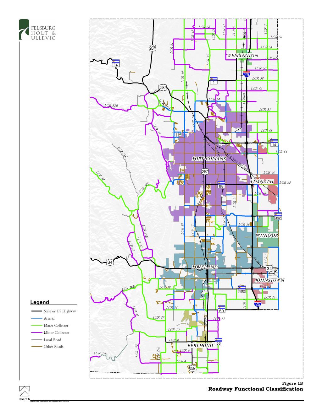
7 Transportation Plan II. INVENTORY OF EXISTING TRANSPORTATION SYSTEM To understand how the transportation system functions in Larimer County today, an update to the inventory of the elements comprising the existing system was conducted. Conducting this inventory was an integral step of the planning process in order to identify areas in need of improvement over the 25 year planning period. This inventory focused primarily on the roadway network and was based on available data on the County s Geographic Information System (GIS) database. The County roadway network provides the dominant means of transportation for this area, with the state highway system serving as the backbone for this network. Vehicular travel, transit systems, and the majority of the bicycle travel in the County rely heavily on a well maintained and complete roadway network. A. Functional Classification A roadway network is comprised of a hierarchy of roadways whose functional classifications are defined by their usage. In general, streets serve two functions; they provide access and mobility. The relative degree to which a road serves these functions defines its functional classification. In order of their ability to provide mobility, the roadway functional types are more thoroughly described as follows: State and U.S. Highway System Much of the primary regional roadway system in Larimer County consists of roads that are maintained by the federal and state governments: Interstate 25 (I-25) is the county s only Freeway, defined by high speeds and access provided by widely spaced, grade-separated interchanges. US 34, US 36 and US 287 are the other federal highways with segments within the county. These highways all provide regional mobility functions to and through the county. State Highways in the county include segments of SH 1, SH 7, SH 14, SH 56, SH 60, SH 68, SH 392 and SH 402. These roads generally serve arterial roadway functions. Arterials Arterials carry longer-distance traffic flow for regional, intercommunity and major commuting purposes. Arterials have a limited number of at-grade intersections and, only when other alternatives do not exist, direct property access. Arterials can carry significant traffic volumes at higher speeds for longer distances, and are seldom spaced at closer than one-mile intervals. Within Larimer County, any roadway with a possibility of requiring widening to four-lanes is designated as an arterial based on the needed right-of-way width. Felsburg Holt & Ullevig Page 3
8 Transportation Plan Major Collectors Major collectors are the next highest classification and are higher speed roadways where mobility still takes precedence over access. This designation is also used for rural primary facilities where the arterial classification is not warranted by lanes or volumes. Minor Collectors Minor collectors serve as main connectors between communities and neighborhoods. They distribute traffic between arterials/major collectors and local roads. Most of the traffic on minor collectors has an origin or a destination within the community. Also known as rural secondary facilities, this classification includes most county roads that are numbered and are not classified as major collectors or arterials. Local Roads The primary function of local roads is to provide access to adjacent land uses, whether it be residences, businesses, or community facilities. Local streets generally are internal to or serve an access function for a single neighborhood or development. Traffic using local roads should have a close-by origin or destination. Typically, county numbered roadways with a local classification are limited in length and continuity. Figures 1A and 1B illustrate the roadway functional classifications. B. Regional Roads County roads that have a primarily regional function, as opposed to primarily serving travel demands within the unincorporated county, form the basis for the Regional Road Capital Expansion Fee. Roads that fulfill a predominantly regional function have been preliminarily identified by members of the North Front Range and Upper Front Range planning organizations to be the subject of a planned Regional Transportation Authority ballot question. Those roads that are also Larimer County roads will form the Regional Road system that will be the focus of the Regional Road Capital Expansion Fee, including segments of: Prospect Road/Larimer County Road (CR) 44; CR 38 (the eastern extension of Harmony Road/SH 68); CR 32/Carpenter Road (the western extension of SH 392); CR 30; Crossroads Boulevard/CR 26; CR 18 (the eastern extension of SH 402); CR 19/Taft Hill Road/Wilson Road; CR 17 / Shields Street /Taft Road; Felsburg Holt & Ullevig Page 4
9 Transportation Plan CR 11C/CR 11/Timberline Road; CR 9/Boyd Road; and CR 5. The County Regional Roads are shown on Figure 2. Felsburg Holt & Ullevig Page 5
10
11
12
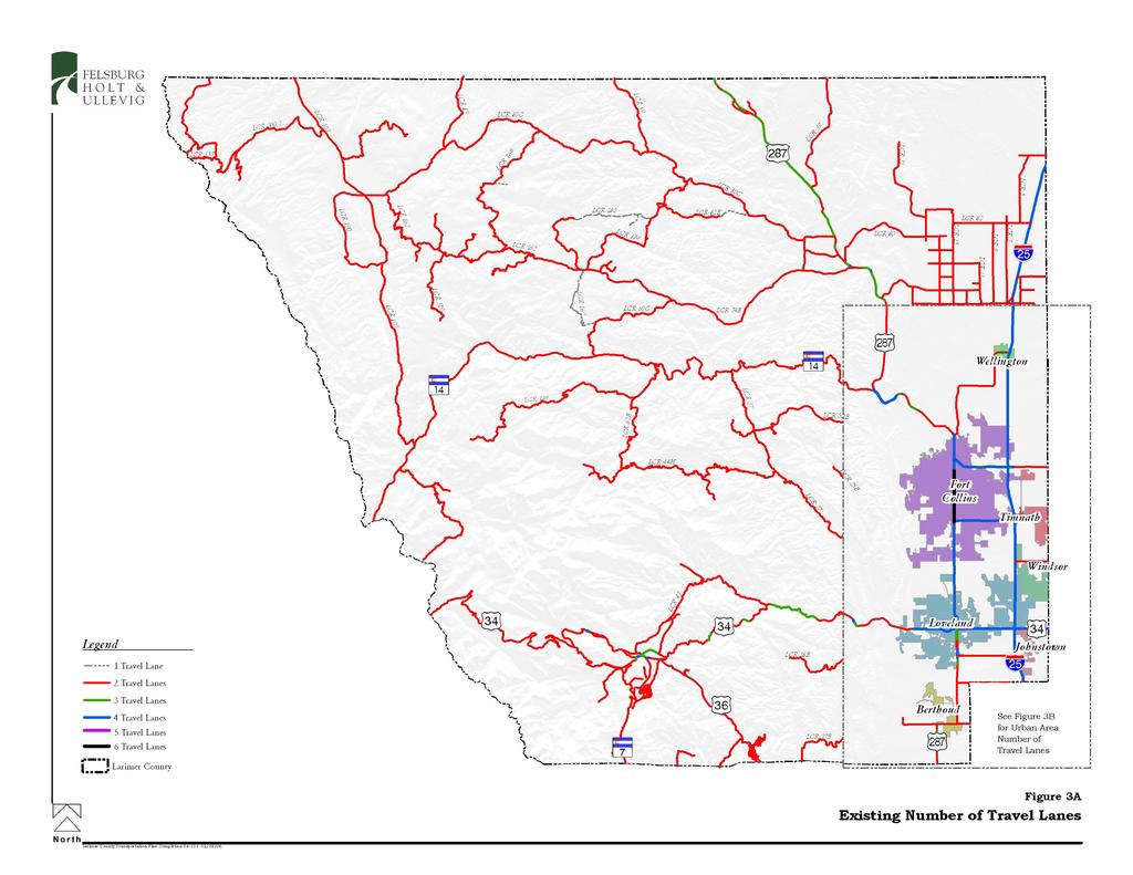
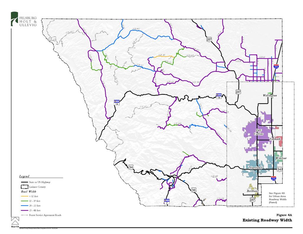
13 Transportation Plan C. Roadway Conditions Travel Lanes Figures 3A and 3B show the existing laneage on the State Highway and County maintained Road systems. The majority of the roads in Larimer County consist of two travel lanes. I-25, US 34 through Loveland, and sections of US 287, SH 68 and SH 14 consist of four lane crosssections. US 287 through Fort Collins consists of six travel lanes. Various roadway segments, particularly in the mountainous portion of the County consist of three lanes, with the third lane acting as a climbing or passing lane. Several unpaved roads in the mountainous areas consist of a single travel lane. Surface Conditions Figures 4A and 4B illustrate the surface conditions (paved versus unpaved) of the Larimer County roadway network, as well as the roadway width ranges for the paved roadways. All State Highways in the County are paved. The majority of the County roads in the urban areas are paved, while many of the rural and mountainous roads are unpaved. Overall, approximately half of the roadway miles on the County roadway network are paved. Area Type Larimer County has diverse terrain; it transitions from plains in the eastern portion of the County to mountainous in the central and western portions. Additionally, Larimer County contains both urban and rural areas. The County has been divided into three area types for the purpose of developing Capital Expansion Fees; Urban, Rural and Mountainous. The majority of the roadway miles in the County (52%) are classified as mountainous. Approximately 36% of the roadway miles are rural, and the remaining 12% are urban. D. Traffic Volumes Traffic volumes are one indicator of the relative importance of a roadway in an area. When compared to roadway capacity estimates, traffic volumes also reveal generally how a road is functioning (level of service) and if improvements to increase capacity are necessary. The most commonly used measurement of traffic volume is average daily traffic (ADT). ADT is defined as the total number of vehicles passing a certain point in both directions in a 24-hour period. Larimer County maintains a database of daily traffic volume counts on both the County Roads and the State Highway system. The data provided are generally from the last three years. Figures 5A and 5B illustrate the existing daily traffic volume range for all roadways on the County s major roadway system. A complete list of traffic volumes on the major roadway system is also included in Appendix A. Felsburg Holt & Ullevig Page 9
14
15
16
17
18
19
20 Transportation Plan Table 1 provides a summary of the mileage and vehicle miles of travel on County Roads which fall within each functional classification in unincorporated Larimer County. Roadways in the collector and arterial street categories comprise the major roadway system. These major roads account for 84% of the total roadway mileage, but carry 98% of the travel. Table 1. County Road Miles and Vehicle Miles of Travel by Functional Classification Functional Classification Roadway Distance Distance (Miles) Percent of Total County Mileage Vehicle Miles of Travel Vehicle Miles of Travel Percent of County Vehicle Miles of Travel Arterial % 425,500 49% Major Collector % 290,700 34% Minor Collector % 131,400 15% Local Roads % 17,100 2% Total % 864, % A detailed inventory of the County s major roadway system, consisting of arterial and collector County Roads, is provided in Appendix A. E. Roadway Capacities A roadway s capacity can be defined as the maximum traffic volume that can be accommodated at desired levels of service. Capacity is defined differently for different roadway types, as described below. Unpaved Roads The Colorado Department of Public Health and Environment requires that any unpaved roadway which has vehicle traffic exceeding 200 vehicles per day in attainment areas be paved or treated for dust abatement. For the purposes of this document, unpaved roads are separated into three categories: Native surface or untreated gravel; Treated gravel; and Chip-seal. Felsburg Holt & Ullevig Page 16
21 Transportation Plan Native surface or untreated gravel roads are ones that have not received any surface treatments. Treated gravel roads are roads that have been treated with chemicals to control dust. There are also a relatively small number of roads in the County that have been treated with a chip-seal technique. Chip-seal is an inexpensive treatment which creates an adequate roadway surface for small volumes of traffic, but which wears down quickly with higher traffic volumes. Larimer County requires that untreated gravel or native surface roadways with traffic volumes greater than 200 vehicles per day be treated. The Larimer County Land Use Regulations require that gravel and chip-seal treated roads that carry more than 400 vehicles per day be paved to a standard asphalt surface. Table 2 shows the daily capacities used in this study for those road segments classified as unpaved. Table 2. Capacity Assumption for Unpaved Roads Capacity (Vehicles Per Day) Unpaved native Unpaved treated gravel Chip Seal Source: Colorado Air Quality Control Commission, Colorado Department of Public Health and Environment Source: Larimer County Land Use Regulations Paved Two-Lane Roads Level of service (LOS) is commonly used to define the quality of traffic flow on various roadway types based on a comparison of traffic volumes with roadway characteristics. A LOS scale ranging from A to F is used to define the quality of flow, with LOS A representing an essentially free-flow situation and LOS F representing the highest levels of congestion, with traffic volumes exceeding the intended capacity of the roadway. Larimer County has established LOS guidelines for County Roads, which are LOS D or better in urban areas and LOS C or better in rural areas. The nationally accepted source for highway capacity evaluations, the Highway Capacity Manual (Transportation Research Board, 2000), along with typical traffic flow characteristics, have been used to approximate the maximum daily traffic volumes for two lane roadways to achieve Larimer County s LOS criteria of LOS D in urban areas and LOS C in rural areas. Additionally, the capacity numbers have been calibrated to more specifically reflect conditions in the study area. These capacities range from 15,300 vehicles per day on roads with full width lanes and shoulders in urban areas to 1,900 vehicles per day on roads with narrow lanes and no shoulders in the mountainous areas. Table 3 outlines the assumptions used in calculating the two-lane roadway capacities, and Table 4 provides the resulting daily capacities based on lane and shoulder widths. Felsburg Holt & Ullevig Page 17
22 Transportation Plan Table 3. Capacity Assumptions for Paved Two-Lane Roads Urban Rural Mountain Level of Service LOS D LOS C LOS C Terrain Level Rolling Rolling Directional Split 60%/40% 60%/40% 60%/40% Heavy Trucks 3% 3% 2% Recreational Vehicles 1% 1% 5% No Passing Zones 60% 30% 60% Peak Hour Factor Daily Traffic in Peak Hour 9% 8.5% 8.5% Segment Length 1 mile 1 mile 1 mile Base Free Flow Speed 55 mph 60 mph 55 mph Access/Mile Highway Class Class I Class I Class I Table 4. Daily Capacities of Paved Two-Lane Roads Useable Shoulder Width (feet) 12-Foot Lanes 11-Foot Lanes 10-Foot Lanes 9-Foot Lanes Urban ,300 13,100 10,700 7,700 14,700 12,300 10,000 6,600 7,700 4,600 3,700 Rural ,000 8,500 7,000 5,000 9,500 8,000 6,400 4,200 5,000 3,000 2,400 Mountainous ,300 7,100 5,800 4,100 7,600 6,400 5,100 3,400 4,100 2,400 1,900 Source: Highway Capacity Manual, 2000 for all urban level capacities as well as initial rural and mountainous values. Hand balancing was completed for segments with similar geometrics, and to reflect lower capacities for narrower shoulders in rural and mountainous areas. Felsburg Holt & Ullevig Page 18
23 Transportation Plan Multi-Lane Roads Capacities of roads with four lanes were estimated based on typical traffic flow characteristics and capacities per hour per lane that have been developed as part of the North Front Range travel demand model. A three lane road is a road where the third lane serves as a continuous shared left-turn lane. This type of roadway improves traffic flow over a typical two-lane road by allowing turning vehicles to wait in dedicated turn lanes, out of the way of through traffic. Capacities for threelane roads were estimated by reviewing field data from three-lane segments, baselining that information against the two- and four-lane capacities shown above, and running the two-lane Highway Capacity Software module with 0 access points per mile. Table 5 shows the daily capacities for multi-lane roads and Table 5 shows the daily capacities of urban and rural roads based on the number of lanes. Table 5. Daily Design Capacities for Multi-lane Roadways Lanes Urban (LOS D) 1 Rural (LOS C) 3 23,000 ADT 15,400 ADT 4 32,000 ADT 24,500 ADT Source: North Front Range Regional Travel Model, converted to daily assuming 9% of daily traffic in peak hour. 1 Modified from NFR Regional Travel Model to reflect LOS D Based on these techniques and the roadway inventory data, the capacity of each roadway segment is defined for the major roadway system in Appendix A. F. Volume to Capacity Ratios One operational measure that is used to define operational characteristics is volume to capacity ratio (v/c). This is the daily traffic volume on a given roadway divided by the daily capacity of that roadway. The daily capacity thresholds described in Section II-E are the basis for the v/c ratios. These ratios are used to describe congestion on street segments, and were used to determine the needed roadway improvements. Road segments with v/c ratios greater than one are slated for improvements. Felsburg Holt & Ullevig Page 19
24 Transportation Plan G. Bicycle Facilities The Larimer County Parks & Open Lands, Engineering, and Road & Bridge Departments have been implementing a bikeway system over the last ten to 20 years. These bikeways include designated bike routes, on-street striped bike lanes and off-road multi-purpose trails. Each of these bike facilities has specific definitions and is described as follows: Bicycle Trails A trail, path, or segment of a bikeway completely separated from the roadway and used exclusively for bicyclists and pedestrians (i.e. off-street recreational trails and sidewalk trails). Bicycle Lane A portion of a roadway designed for bicycles, distinguished by a paint stripe, curb or similar device. Bicycle Route A system of bikeways which interacts with motorized traffic, does not have a separate lane, and is designated by route markers. Bicyclists must share the same roadway with vehicles. The cities of Fort Collins and Loveland have also taken steps toward developing a bikeway and trail system. H. Transit Systems Larimer County is served by both public and private transit providers. Four fixed-route systems are operated in the County as well as a number of demand responsive services. A summary of each of the existing transit services is provided below. More detailed information on each system including operating characteristics, measures of effectiveness, financing, fleet, and facilities can be found in the North Front Range 2030 Regional Transportation Plan and the Upper Front Range 2030 Regional Transportation Plan. Larimer County Specialized Transportation Through Transfort, Larimer County s Health and Human Services department provides a demand responsive service open to northern Larimer County residents that live outside the Fort Collins Urban Growth area, in Laporte, or in Wellington. The fare for this service is $2.50 with reduced fares available for those who qualify. The hours of operation are 6:30 AM to 6:30 PM Monday through Friday. City of Fort Collins Transfort/DAR The City of Fort Collins operates Transfort, a fixed-route service, and Dial-A-Ride (DAR), a demand responsive and paratransit service. Dial-A-Ride provides service to senior citizens and individuals who qualify under the American Disabilities Act. Service is provided in the urbanized Fort Collins area and parts of Larimer County. Felsburg Holt & Ullevig Page 20
25 Transportation Plan Service operates Monday through Saturday with more frequent service when Colorado State University is in session. Fares for fixed-route Transfort service are $1.25 per ride and $0.60 for seniors and disabled passengers. DAR fares are $2.50 per ride. The FoxTrot, a regional route connecting Fort Collins and Loveland, is also operated by Transfort. One-way fare is $1.25. This route is funded by Fort Collins, Loveland, and Larimer County. City of Loveland Transit COLT COLT operates two fixed-routes and provides funding for the regional FoxTrot route connecting Loveland and Fort Collins. In addition, COLT operates a demand-response service for elderly and disabled residents of Loveland called the Mini Bus. COLT s service operates Monday through Saturday. The regular fares are $1.25 for a one-way ride. People who are elderly, have disabilities, and the youth pay $0.60 per ride. Special rates are also available for low income residents. Seniors and ADA-eligible people qualify for paratransit service. Paratransit fares are $2.00 for a single ride. Rocky Mountain National Park The fourth fixed-route system operating in the region is the service operated by Rocky Mountain National Park. The shuttle bus service runs along the Bear Lake Road corridor in the summer months. It generally begins operation in mid-june. During peak periods, this service operates seven days a week through the weekend following Labor Day. After that, the shuttle bus service operates only on Fridays, Saturdays and Sundays through Columbus Day. The shuttle bus service does not operate in the winter months. There is no charge for the service. The Rocky Mountain National Park service is operated by a contractor, and many of the drivers are school bus drivers in Estes Park during the school year. Town of Berthoud Berthoud Area Transportation Services (BATS) The Town of Berthoud operates demand responsive service, not only within Berthoud but also for the surrounding rural area, within the limits of the Berthoud Rural Fire Protection District. This district, most of which is still classified as rural, includes portions of Boulder and Weld Counties as well as Larimer County. This demand-responsive service is operated from 7:00 AM to 4:00 PM, Monday through Friday. The fare for local service is $0.50 per ride. The suggested donation for out-of-town trips is $2 to $5, depending on income. Felsburg Holt & Ullevig Page 21
26 Transportation Plan Town of Estes Park Special Transit Special Transit has been serving Estes Park since 1999 with door-to-door specialized transit services. The service operates four days per week in Estes Park and operates once per month between Estes Park and Loveland. Fares within Estes Park are $1.25 per ride. Fares between Estes Park and Loveland are $3.00 per ride. Passengers call in advance for the service and may schedule trips as much as two weeks in advance. Wellington Senior Center The Town of Wellington through its Senior Services Center operates a limited demand responsive service for residents to Fort Collins and/or Loveland. VanGo The North Front Range Metropolitan Planning Organization operates the VanGo vanpool program which provides service in Larimer County. Currently about 39 vans originated in Fort Collins; about one-third of these vans travel into downtown Denver while the other half travel into the Denver Metro area, Greeley and Wellington. Another six vans originate in Loveland and travel to the Denver Metro area and Fort Collins 1. TNM&O Coaches/Greyhound TNM&O/Greyhound is a private transit provider that operates inter-regional bus services from Fort Collins in Larimer County. I. Rail System The rail transportation system in Larimer County primarily serves the purpose of moving freight. Passenger rail service is currently not available in the County. Figure 6 depicts the existing rail system for the County and the surrounding areas. Table 6 summarizes the existing rail service and the track condition based on the age of the track bed and the weight of the rail. The Union Pacific Railroad, the Burlington Northern Santa Fe Railroad and the Great Western Railway each operate rail lines in the County. As shown on Figure 6, there is also an abandoned rail line extending northwest from Fort Collins. 1 North Front Range MPO, June Felsburg Holt & Ullevig Page 22
27
28 Transportation Plan Table 6. Rail System Rail Segment Owner Length Condition 1 Denver-Boulder- Longmont-Loveland-Fort Collins Fort Collins-Cheyenne Denver-Greeley-Fort Collins Fort Collins-Windsor- Greeley Burlington Northern Santa Fe Railroad Burlington Northern Santa Fe Railroad 23 miles Fair 29 miles Poor to Fair Union Pacific Railroad 22 miles Good Great Western Railway 9 miles Poor to Fair Loveland-Johnstown Great Western Railway 10 miles Poor to Fair 1 Overall condition of existing track based on age of track bed and weight of rail for passenger rail usage in the future. Felsburg Holt & Ullevig Page 24
29 Transportation Plan III. IDENTIFICATION OF SHORT RANGE ROADWAY IMPROVEMENT NEEDS A. Unit Cost Estimates Planning-level, 2005 unit costs were developed for the different roadway improvement types identified in the plan. Urban roadway sections used to calculate quantities (per mile basis) were those shown in the Larimer County Urban Area Street Standards, adopted by Larimer County, Fort Collins and Loveland in Where differences exist in the cross-sections by jurisdiction, (such as bike lane, sidewalk, and median widths) the larger values were generally used for quantity calculation. Rural roadway sections were based on two 12 foot lanes and two six foot shoulders with widening at intersections accommodating left turn lanes. A total length of approximately 1700 feet was used to include taper, deceleration and storage for turn lanes throughout the one mile rural section. Engineering design and construction management, mobilization and traffic control were included in each estimate. They were calculated based on a percentage of the estimated construction costs. Unit costs were developed using recent bid tabulations in the Larimer County area. Validation of the unit costs was made by comparison with CDOT Average Unit Bid Prices (2004). Where no unit costs for items were included in the Larimer County values, CDOT Average Unit Bid Prices were used. Costs do not include right-of-way, landscaping or aesthetic upgrades, or major utility additions or relocation. All unit costs should be treated as order of magnitude; actual construction costs will differ for specific roadways depending on topography, required structures, number of access points, and other roadway characteristics. The conceptual cost estimates are summarized in Table 7, and the quantity calculations and cost estimate worksheets are included in Appendix B. Table 7. Conceptual Unit Cost Estimates Cost per Roadway Mile Improvement Category Area Type Mountainous Rural Urban Native to Treated Gravel $500,000 $500,000 n/a Lane and Shoulder Widening * $1,550,000 $1,000,000 $1,450,000 Pave Gravel Road $1,550,000 $1,000,000 $1,450,000 Construct New 2-Lane Road $2,350,000 $1,850,000 n/a Widening of 2-Lane to 3-Lane (semi-urban) ** n/a $2,850,000 $2,850,000 Upgrade to 4-Lane Urban Arterial ** n/a n/a $5,100,000 * Applies to Widening of Existing 2-Lane Paved Roads ** Includes Typical Numbers of Traffic Signals COSTS EXCLUDE ALLOWANCE FOR: Right-of-Way Costs Landscaping/Aesthetic Upgrades Utility Addition/Relocation Felsburg Holt & Ullevig Page 25
30 Transportation Plan B. Roadway Improvement Projects Four roadway improvement project types have been identified which have the primary purpose of providing adequate roadway capacity to serve travel demand. Short-range project needs have been identified based on existing travel demand. In the case of both paving and widening needs, it is recommended that these improvement projects result in widening to full two-lane roadway standards (twelve-foot lanes and six-foot shoulders) to provide the safest roadways possible and prevent the need for more costly future improvements. Upgrade Native Surface Roads to Treated Gravel Roads Seven native surfaced roadways are currently operating with volumes greater than capacity. These seven segments, totaling approximately 28.3 miles in length, will be able to meet the current demand when they are upgraded to treated gravel surfaces. Roadway Paving Projects The inventory of existing roadway conditions indicates that more than half of the roads in the County are currently unpaved. Using the capacity criteria described in Section II-E, 37.7 miles on the major roadway system have been identified as requiring paving. These segments are shown on Figures 7A and 7B. In addition, 1.3 miles of local roads have volumes that require paving to meet current standards. Lane and Shoulder Widening As an alternative to adding lanes to two lane roads, it was determined that capacity requirements on several road segments could be met by widening the travel lanes and shoulders. Approximately 7.1 miles of road will be able to meet the current capacity demands with this upgrade. Roadway Widening Where traffic volumes currently exceed the capacity of full-width two-lane roadways, two widening options were considered: adding a third lane and widening to a full four-lane roadway. One roadway segment currently has a volume that exceeds the capacity of full-width two-lane roadways, and has been identified as requiring widening to three lanes. This segment is approximately ½ mile. The various segments and their type of needed improvement are shown graphically on Figures 7A and 7B. Felsburg Holt & Ullevig Page 26
31


32 WXYZÕ I³ I³ LCR 21 LCR 19 LCR 17 LCR 68 LCR 15 LCR 13 WXYZÉ LCR 11 LCR 9 LCR 7 LCR 3 WELLINGTON!"`$ LCR 60 LCR 58 LCR 56 LCR 66 LCR 64 LCR 62 LCR 52E LCR 54G LCR 54 BNSF RR LCR 52 LCR 23 LCR 48 LCR 25E WXYZÕ LCR 44 LCR 27 I³ WXYZü LCR 36 LCR 40 LCR 38 LCR 9 LCR 17 UP RR FORT COLLINS BNSF RR LCR 38E GREAT WESTERN RAILWAY TIMNATH LCR 29 LCR 27 LCR 25E LCR 19 LCR 17 LCR 11 LCR 30 WXYZô WINDSOR LOVELAND UP RR LCR 3 Iy Legend Pave Widen Add Third Lane Upgrade to Treated Gravel Widen Lanes and Shoulders State or US Highway Other Roads LCR 37E LCR 18E LCR 31 LCR 27E LCR 18 LCR 14 LCR 29 LCR 10 LCR 8 LCR 23E LCR 6 LCR 4 KÂ BNSF RR BERTHOUD WXYZô LCR 12 WXYZð WXYZö LCR 7 JOHNSTOWN!"`$ LCR 18 LCR 16 Larimer County Figure 7B Short Range Roadway Improvement Needs Larimer County Transportation Plan Completion /02/06
33 Transportation Plan A summary of the short range improvement needs and the resulting estimated construction costs are provided in Table 8. Table 8. Short Range Roadway Improvement Needs Improvement Type # Of Projects Project Mileage Estimated Cost Major Roads Upgrade to Treated Gravel $13,220,000 Paving (Current & Planned Major Roads) $46,167,000 Widen Lanes & Shoulder $8,995,000 Additional Lanes $1,439,000 Subtotal Major Roads $69,821,000 Local Roads Upgrade to Treated Gravel $942,000 Paving $2,425,000 Subtotal Local Roads $3,367,000 Total $73,188,000 Felsburg Holt & Ullevig Page 29
34 Transportation Plan IV. LONG RANGE TRANSPORTATION SYSTEM A. Growth in the County In order to identify potential improvement projects for the transportation system in Larimer County, it is important to first understand the nature and volume of traffic in the County in the future. The analysis of future traffic volumes in Larimer County is based on the 2030 regional travel demand model developed by the North Front Range Metropolitan Planning Organization (NFR MPO), the Estes Valley Transportation Alternatives Study (Felsburg Holt & Ullevig, April 2003) and information from the Colorado State Demographer. The NFR travel demand model covers the urban portion of Larimer County and generally extends west to CR 27 and north to Weld County Road 88. The model divides the NFR into 815 transportation analysis zones (TAZs), 508 of which are in Larimer County. The traffic modeling process assigns different trip generation characteristics to households with various income levels, as well as to employment in the production, retail and service sectors. The model includes household and employment forecasts for 2030 by TAZ, along with baseline household and employment data for the year Within the NFR model area of Larimer County, the number of households is expected to increase from 91,190 in 2000 to 174,286 in This growth represents an approximate annual growth rate of 2.2% per year. These household numbers can be converted to population using the Larimer County average household size of 2.52 (per the Colorado State Demographer). The Estes Valley Transportation Alternatives Study shows a population of 11,034 in 2000 for the Estes Valley (which extends beyond the City of Estes Park) and a forecasted buildout population of 19,000. Assuming that the Estes Valley will be built out by 2030, the result is an annual growth rate of approximately 1.83%. Larimer County as a whole had a population of 253,130 in The Colorado State Demographer estimates an increase of approximately 1.87% per year over the thirty year time horizon of this plan. This growth rate was applied to areas outside of the NFR model area and the Estes Valley. Information from these three sources can be combined to estimate the total 2030 population in Larimer County, as shown in Table 9. Overall, the County is estimated to have a population of nearly 480,000 in 2030, representing an overall growth rate of 2.15% per year. Felsburg Holt & Ullevig Page 30
35 Transportation Plan Table 9. Larimer County Population Forecasts Annual Growth Rate Within NFR Model Area 229, , % Estes Valley 11,034 19, % Remainder of Larimer County 12,297 21, % Larimer County Total 253, , % Unincorporated Larimer County (Approximate Area) B Traffic Volume Projections 52, , % The 2030 travel demand forecasts were derived using a combination of the NFR travel demand model and the growth rates identified in Table 9. For all roadways included in the NFR model area, the 2030 forecasts were taken directly from the travel demand model. Because the NFR model is focused on the entire region, some of the roads in the Larimer County major roadway system are not included in the model. For these roads, an annual growth rate of 2.2% was applied to the existing traffic volumes to forecast the 2030 daily traffic volumes. For all roadways outside of the NFR model area, an annual growth rate of 1.85% (average of Estes Valley and State Demographer s growth rates) was applied to the existing traffic volumes to forecast the 2030 daily traffic volumes. The resulting 2030 daily traffic volume forecast ranges are shown on Figures 8A and 8B. Overall, the vehicle miles of travel on the County roadway network are forecast to almost double over the 25 year time horizon (a 95% increase). Specific traffic volume forecasts by roadway segment are included in Appendix A. C Volume to Capacity Ratios As described previously, volume to capacity ratio (v/c) is a planning level measure of the level of service experienced by the roadway user. The v/c ratio on each segment of the major roadway system was calculated using the forecasted year 2030 traffic volumes and the short-range capacities, as defined in Section II-E. Short-range capacities reflect the existing roadway or, if a short-range improvement was identified, the improved capacity. The results of the v/c analysis indicate that, without improvements to the existing roadway network, many roadway segments throughout the County are projected to operate at above capacity conditions. Felsburg Holt & Ullevig Page 31

36 LCR 162 LCR 89 LCR 59 LCR 157 LCR LCR 103 LCR 80C LCR 169 I³ LCR 37 LCR 21 LCR 80C LCR 5 LCR 190 LCR 162 LCR 180 LCR 82E LCR 82 LCR 162 LCR 179 LCR 80 LCR 15 LCR 11 LCR 9 LCR 7!"`$ LCR 103 LCR 319 LCR 60C LCR 74E WXYZÕ LCR 139 LCR 27 WXYZÕ I³ I³ WELLINGTON Wellington LCR 63E LCR 52E 2E LCR 44H LCR 27 LCR LCR 25E 25E Fort FORT Collins COLLINS TIMNATH Timnath Windsor Legend < 1,000 1,001-2,500 2,501-5,500 5,501-10,000 Iy WXYZÍ Estes Park LCR 43 Iy I} LCR 18E LCR 37E Loveland LOVELAND Berthoud KÂ I³ Iy!"`$!"`$ Johnstown See Figure 6B for Urban Area 2030 Traffic Volume Forecasts > 10,000 Larimer County Figure 8A 2030 Traffic Volume Forecasts Larimer County Transportation Plan Capital Expansion Fee Figures /26/06


37 WXYZÕ I³ I³ LCR 21 LCR 19 LCR 17 LCR 68 LCR 15 LCR 13 WXYZÉ LCR 11 LCR 9 LCR 7 LCR 3 LCR 64 WELLINGTON WELLINGTON!"`$ LCR 60 LCR 58 LCR 56 LCR 66 LCR 62 LCR 52E LCR 54G LCR 54 BNSF RR LCR 52 LCR 23 LCR 48 LCR 25E WXYZÕ LCR 44 LCR 27 I³ WXYZü LCR 40 TIMNATH LCR 38 LCR 36 LCR 9 LCR 17 UP RR FORT COLLINS BNSF RR LCR 38E FORT COLLINS GREAT WESTERN RAILWAY TIMNATH LCR 29 LCR 27 LCR 25E LCR 19 LCR 17 LCR 11 LCR 30 WXYZô WINDSOR LOVELAND LOVELAND UP RR LCR 3 Iy Legend 2030 Volume Forecasts < 1,000 1,001-2,500 2,501-5,500 5,501-10,000 > 10,000 Larimer County LCR 37E LCR 18E LCR 31 LCR 27E LCR 18 LCR 14 LCR 29 LCR 10 LCR 8 LCR 23E LCR 6 BERTHOUD LCR 4 I³ BNSF RR BERTHOUD WXYZô LCR 12 WXYZð WXYZö LCR 7 JOHNSTOWN!"`$ LCR 18 LCR 16 Figure 8B 2030 Traffic Volume Forecasts Larimer County Transportation Plan Completion /17/06
38 Transportation Plan V. IDENTIFICATION OF LONG RANGE IMPROVEMENT NEEDS A. Roadway Improvement Projects Capacity-driven roadway improvement needs were identified for the long range future (through year 2030) in a similar manner as short range improvement needs. Figures 9A and 9B show long range capacity driven roadway improvement needs, including roadway paving projects and widening projects (additional lanes). These project needs are in addition to those needs identified previously that are associated with existing traffic levels. Upgrade Native Surface Roads to Treated Gravel Roads Eleven native surfaced roadways have forecasted volumes greater than their capacity. These eleven segments are approximately 49.6 miles in length and will be able to meet the 2030 demand when they are upgraded to treated gravel surfaces. Roadway Paving Projects Eighty segments of the major County roadway system are forecast to have traffic levels requiring paving by 2030, comprising roadway miles. Additionally, ten segments of local roads, comprising approximately 12.9 roadway miles, are forecast to require paving by Lane and Shoulder Widening Eighteen road segments comprising approximately 12 miles have been identified for receiving lane and shoulder widening. With this improvement, those segments will be able to meet 2030 traffic volume demands. Roadway Widening Twenty two-lane roadway segments have been forecast to require widening to three or four lanes by 2030 to accommodate traffic growth at desired levels of service. These 20 projects total approximately 15.6 miles. A summary of the long range improvement needs and the resulting estimated construction costs are provided in Table 10. These projects and costs are in addition to the projects shown for the Short Range. Felsburg Holt & Ullevig Page 34


39 59 LCR 89 LCR LCR 80C LC R 16 9 ³ I LCR LCR 82E LCR 82 2 LCR LCR 16 LCR 10 LCR LCR 60C $ "! LCR 74E 3 I ³ ³I Õ Z Y X W WELLINGTON Wellington 27 LCR Õ Z Y X W LCR 7 LCR LCR 9 LCR LCR 16 80C LCR LCR LCR 180 LCR 5 LC R LCR 21 LCR 157 LC R R LC LCR 20 LCR 139 LCR 63 E LCR 52E 2E LCR 44H EE 2255 RR LLCC R LC 27 Fort FORTCollins COLLINS TIMNATH Timnath LC R 43 Windsor y I Legend Pave y I Estes Park Widen LOVELAND Loveland $ "!! $ " LCR 18E Add Third Lane Add Lanes } I Upgrade to Treated Gravel Widen Lanes and Shoulders State or US Highway Other Roads Larimer County Í Z Y X W yi I y Johnstown Berthoud LCR 37E K Â ³I See Figure 9B for Urban Area Long Range Improvement Needs Figure 9A Long Range Roadway Improvement Needs


40 WXYZÕ I³ KÂ LCR 21 LCR 19 LCR 17 LCR 68 LCR 15 LCR 13 WXYZÉ LCR 11 LCR 9 LCR 7 LCR 3!"`$ LCR 66 LCR 64 WELLINGTON LCR 62 LCR 60 LCR 58 LCR 56 LCR 52E LCR 54G LCR 54 BNSF RR LCR 52 LCR 23 LCR 48 LCR 25E WXYZÕ LCR 44 LCR 27 FORT COLLINS LCR 40 TIMNATH I³ WXYZü LCR 36 LCR 38 LCR 9 LCR 17 UP RR LCR 38E BNSF RR GREAT WESTERN RAILWAY LCR 29 LCR 27 LCR 25E LCR 19 LCR 17 LCR 11 LCR 30 WXYZô WINDSOR LOVELAND UP RR LCR 3 Iy Legend Pave Widen Add Third Lane Add Lanes Upgrade to Treated Gravel Widen Lanes and Shoulders State or US Highway Other Roads Larimer County LCR 37E LCR 18E LCR 31 LCR 27E LCR 18 LCR 14 LCR 29 LCR 10 LCR 8 LCR 23E BERTHOUD LCR 6 LCR 4 I³ BNSF RR WXYZô LCR 12 WXYZð WXYZö LCR 7 JOHNSTOWN LCR 18!"`$ LCR 16 Figure 9B Long Range Roadway Improvement Needs
41 Transportation Plan Table 10. Long Range Roadway Improvement Needs Improvement Type # Of Projects Project Mileage Estimated Cost Major Roads Upgrade to Treated Gravel $19,162,000 Paving (Current & Planned Major Roads) $126,113,000 Widen Lanes & Shoulder $13,400,000 Additional Lanes $55,283,000 Subtotal Major Roads $213,958,000 Local Roads Upgrade to Treated Gravel $5,656,000 Paving $15,598,000 Subtotal Local Roads $21,254,000 Total $235,212,000 B. New Roads City, town, county sub-area, and corridor transportation plans were reviewed to identify new roads that are planned in unincorporated parts of the county and whose needs are directly related to anticipated Larimer County development. Table 11 shows the new roads and their estimated construction costs. Table 11. New Roads Transportation Plan Road From/To Town of Wellington Transportation Master Street Plan 1998 Larimer County Transportation Plan North Front Range 2030 Regional Transportation Plan Ronald Reagan Ave. Clinton Ave miles west of CR 9 to 0.50 miles east of CR 9 SH 1 to 0.50 miles east of CR 9 Length (Miles) Road Type Estimated Cost 0.75 Minor Collector $1,390, Minor Collector $925,000 CR 32 SH 287 to CR Arterial $3,700,000 CR 16 CR 15 to SH Minor Collector $185,000 CR 82 CR 15/82 to CR Minor Collector $2,775,000 CR 37E CR 37E to CR Minor Collector $3,700,000 CR 5 CR 20E to SH Arterial $4,475,000 Total $19,150,000 Felsburg Holt & Ullevig Page 37
42 Transportation Plan C. Summary of Roadway Improvement Needs There are about 75 miles of road segments in Larimer County that currently operate above capacity based on existing traffic levels. Short-range road improvement needs to provide needed capacity total about $73,200,000. With the anticipated growth in Larimer County over the next 25 years, it is estimated that an additional 206 miles of road segments will need improvements to meet capacity requirements. The estimated cost for these improvements is $235,212,000. Other new planned roadways, shown in Table 11, total about $19,150,000, which brings the total long term cost to about $254,362,000. Table 12 summarizes the cost estimated for roadway improvements. Table 12. Cost Summary Scenario # Of Projects Project Mileage Estimated Cost Current Roadway Improvement Needs $73,188,000 Long-Range Roadway Improvement Needs $235,212,000 New Roads $19,150,000 Subtotal Long-Range and New Roads $254,362,000 Total Improvement Needs $327,550,000 D. Bicycle Facilities In April 2000, Colorado State Parks completed the Colorado Front Range Trail Corridor Plan. The plan calls for a continuous trail that will link Colorado s front range from New Mexico to Wyoming. The trail will connect existing and planned trail systems to the new trail corridors to provide a complete trail network connecting the population centers throughout the front range. The Front Range Trail corridor will extend through Larimer County, connecting from Lyons to Loveland, Fort Collins and north toward Cheyenne. Larimer County should continue to work with the Colorado State Parks to develop this trail corridor and to provide links from other trails to the Front Range Trail. The North Front Range Metropolitan Planning Organization (NFR MPO) has identified Regionally Significant Corridors throughout the region. Each of these corridors is considered multi-modal, which means they could be used for bicycle and pedestrian purposes. The bicycle/pedestrian-specific Regionally Significant Corridors in the NFR MPO follow the major rivers including the Poudre River, Platte River, Big Thompson River, Little Thompson River and Spring Creek. The North Front Range 2030 Regional Transportation Plan and the Upper Front Range 2030 Regional Transportation Plan each identify bicycle and pedestrian projects in Larimer County within the Fiscally Constrained and Vision Plans. Felsburg Holt & Ullevig Page 38
43 Transportation Plan E. Future Transit System As described in Section IV-A, Larimer County is expected to increase from approximately 250,000 to 480,000 people by the year In addition, the age of the population in Larimer County is increasing. In percent of the population was aged 65 or older; by percent of the population is expected to be 65 or older. These changing demographics will increase demand for transit services both within Larimer County and between Larimer County and neighboring communities. Increasing gas prices can also impact demand for transit services. Communities throughout the US have experienced growth in ridership in excess of 10% over the last year; much of this has been attributed to the increase in the price of gas. At a minimum, each community currently providing transit service should continue to provide service. It is more likely that with the growth in population anticipated, expanding the existing services will be necessary to meet community demand. It will be important that Larimer County work with the communities to provide coordinated rural and regional services. Travel demand projections provided by the North Front Range Metropolitan Planning Organization and the North I-25 Environmental Impact Statement 2 indicate that the US 287 corridor, today and in the future, is one of highest volume travel corridors in Larimer County. Larimer County and the communities along this corridor should plan to address this demand through transit as well as roadway improvements. Transit improvements along the corridor may include increasing the frequency of the regional FoxTrot service and extending the service south to Longmont. Another option for addressing mobility along the US 287 corridor could be commuter rail. The North I-25 EIS has identified the BNSF rail, which parallels the US 287 corridor in northern Colorado, as the route location of choice for a commuter rail service. The rail corridor being evaluated includes rail stations in Fort Collins, Loveland, Berthoud and Longmont. In Longmont, riders could transfer to the planned FasTracks rail line to travel to Boulder and then into Denver or stay on the train to connect into the planned FasTracks North Metro rail line traveling along the east side of I-25 into downtown Denver. Larimer County should plan to: Support increased and enhanced FoxTrot service Preserve right of way along the BNSF rail line Facilitate coordination of rural service providers Support intercity service between Larimer County communities Support regional services from Larimer County communities to Denver, Boulder, Longmont, Greeley and Windsor. 2 Currently being conducted by CDOT Region 4 in conjunction with the Federal Highway Administration and the Federal Transit Administration. Felsburg Holt & Ullevig Page 39
44 Transportation Plan VI. GUIDING PRINCIPLES AND IMPLEMENTING STRATEGIES Following are the guiding principles, along with strategies for implementing those principles, contained in the Transportation section of the Larimer County Master Plan. TR-1 The Larimer County transportation planning process shall complement the development patterns and principles of the Master Plan. TR-1-s1 The Functional Road Classification Map shall be used as the official future roadway plan for the County. TR-1-s2 The Land Use Code shall establish roadway standards that enhance capacity and safety, improve air quality and aesthetics and implement the development patterns of the Land Use Framework Map. TR-1-s3 County road projects shall be designed and constructed in a manner that minimizes the impact on water quality and sensitive environmental areas and considers aesthetics. TR-2 New development shall occur only where existing transportation facilities are adequate or where necessary improvements will be made as part of the development project. TR-2-s1 Adequate facilities and service levels for transportation shall be clearly defined in the Land Use Code. In Growth Management Areas, service level standards shall reflect those of the adjacent municipality. In other areas, standards shall be based on the density and intensity of the use. TR-2-s2 The Land Use Code shall establish traffic impact requirements to identify the need for improvements created by future development in order to meet adopted level of service standards. TR-3 New development shall pay its equitable share for necessary improvements to the County transportation system. TR-3-s1 The Land Use Code shall require construction of improvements identified through a traffic impact study. TR-3-s2 The Land Use Code shall include a traffic improvement fee to support other future improvements to the County transportation system made necessary by the impact of the development, including cumulative impacts. TR-3-s3 The Land Use Code shall establish a mechanism to allow a party who initially funds an improvement to be reimbursed by future developments that also impact that facility. Felsburg Holt & Ullevig Page 40
45 Transportation Plan TR-4 Larimer County shall encourage the development and use of alternative modes of transportation. TR-4-s1 Larimer County will continue to participate in cooperative efforts with cities and counties in the region to develop a preferred transit system within Growth Management Areas and between cities and towns, consistent with the adopted Transit Development Plan. TR-4-s2 Larimer County shall establish a bicycle plan that recognizes the need to serve both commuters and recreational users and that coordinates with the plans of adjoining cities and counties. TR-4-s3 Larimer County shall support the regional Travel Demand Management (TDM) program by encouraging all major employers to adopt a TDM program and by adopting incentives for promoting use of alternative modes of transportation and for implementing telecommuting programs. TR-4-s4 Larimer County shall continue to support the study and development of commuter rail service in the Northern Front Range. TR-5 Larimer County shall establish a Capital Improvement Program for County transportation facilities. TR-5-s1 The Capital Improvement Program shall identify a methodology for prioritizing projects which emphasizes the importance of maintaining the existing roadway system. TR-5-s2 The Capital Improvement Plan for roadway maintenance and improvement shall consider consistency with the Master Plan as an element of project prioritization. TR-5-s3 The Capital Improvement Program shall identify methods to share costs with adjacent cities and other governmental entities. TR-5-s4 The Capital Improvement Program shall consider funding for alternative transportation mode projects including facilities for bicycles and transit. Felsburg Holt & Ullevig Page 41
46 Transportation Plan APPENDIX A ROADWAY INVENTORY Felsburg Holt & Ullevig Appendix A
47 APPENDIX A - ROAD INVENTORY Larimer County Road Section FROM TO Func Class Juris. UGA Regional CR? Area Type ADT Date 2030 ADT Forecast Source Length (MI) Curr VMT 2030 VMT Road Surface Width (FT) Lane QTY. Shld Width Capacity (VPD) Current V/C Short-Range Needs Short Range Costs Improved Capac (VPD) 2030 V/Existing Capacity 2030 V / C 2030 Needs 2030 Improved Capacity LCR 2 002E US 287 CR 17 Major Collector LCRB NO NO R 1, ,200 NFR Model ,602 Paved - High Type Bituminous , , , E CR 17 CR 15 Major Collector LCRB NO NO R ,200 NFR Model ,177 Paved - Low Type Bituminous Pave $1,001,000 10, , H LONGS PEAK PARK LOT SH 7 Local Roads LCRB NO NO R ,300 Growth Factor ,260 Paved - High Type Bituminous , , ,500 LCR 3 LCR 4 LCR 5 LCR 6 LCR 7 LCR 8 LCR 9 LCR 10 LCR CR 18 JOHNSTOWN CL Minor Arterial LCRB NO NO U ,200 NFR Model ,724 Gravel Pave 15,300 $304, JOHNSTOWN CL JOHNSTOWN CL Minor Arterial LCRB NO NO U ,700 NFR Model ,819 Gravel Pave 15,300 $304, JOHNSTOWN CL CR 20C Minor Arterial LCRB NO NO U ,700 NFR Model ,241 Gravel Pave 15,300 $877, CR 20C US 34 Minor Arterial LCRB NO NO R ,000 NFR Model ,365 Gravel Add Third Lane 15,400 $2,223, CR 30 SH 392 Major Collector LCRB NO NO U ,100 NFR Model ,095 Gravel Pave 15,300 $1,464, SH 392 SURF CHG Minor Collector LCRB NO NO U ,900 NFR Model Paved - High Type Bituminous , , , SURF CHG CR 32E Minor Collector LCRB NO NO U ,900 NFR Model Gravel Pave 15,300 $217, Private Drive TIMNATH CL Local Roads LCRB NO NO R Growth Factor Gravel TIMNATH CL SH 14 Major Collector LCRB NO NO R ,100 NFR Model Paved - Low Type Bituminous Pave 10,000 $500, SH 14 CR 48 Major Collector LCRB NO NO R NFR Model Gravel Pave $750,000 10, , CR 48 CR 50 Major Collector LCRB NO NO R Growth Factor Gravel Pave 10,000 $1,003, CR 50 CR 52 Major Collector LCRB NO NO R NFR Model Gravel Pave 10,000 $1,007, CR 56 CR 58 Major Collector LCRB NO NO R Growth Factor Gravel CR 58 CR 60 Major Collector LCRB NO NO R Growth Factor Gravel CR 60 CR 62 Major Collector LCRB NO NO R Growth Factor Gravel CR 62 CR 64 Major Collector LCRB NO NO R Growth Factor Gravel CR 64 CR 66 Major Collector LCRB NO NO R Growth Factor Gravel CR 66 CR 70 Major Collector LCRB NO NO R Growth Factor Gravel E CR 16 CR 18 Major Collector LCRB NO NO R ,800 NFR Model ,855 Gravel Pave 10,000 $1,003, E CR 42 (NCM) CR 42E Local Roads LCRB NO NO R Growth Factor Gravel F CR 36 CR 38 Minor Collector LCRB NO NO R Growth Factor Paved - High Type Bituminous , , , CR 27E SURF CHG Minor Collector LCRB NO NO R Growth Factor Gravel Pave 10,000 $490, SURF CHG CR 23E Minor Collector LCRB NO NO R 1, ,900 Growth Factor ,529 2,692 Paved - High Type Bituminous , , , CR 23E CR 21 Major Collector LCRB NO NO R 1, ,300 Growth Factor ,782 4,899 Paved - High Type Bituminous , , , CR 21 US 287 Major Collector LCRB NO NO R 1, ,200 Growth Factor ,717 4,785 Paved - High Type Bituminous , , , CR 15 CR 904 Minor Collector LCRB NO NO R Growth Factor Gravel E US 287 CR 17 Local Roads LCRB NO NO R ,100 NFR Model Paved - High Type Bituminous , , , E CR 17 CR 15A Local Roads LCRB NO NO R ,100 NFR Model ,129 Gravel Pave $997,000 10, ,000 $0 005 SH 60 Begin I-25 West Frontage Local Roads LCRB NO NO R Growth Factor Paved - High Type Bituminous , , , WINDSOR CL SH 392 Minor Arterial LCRB YES YES U 3, ,500 NFR Model ,648 4,761 Paved - High Type Bituminous , , , CR 34C CR 36 Minor Arterial LCRB NO YES R 1, ,500 NFR Model ,183 5,743 Paved - High Type Bituminous , , Widen Lanes & Shoulder 10,000 $763, CR 36 CR 38 Minor Arterial LCRB NO YES R ,500 NFR Model ,616 Paved - High Type Bituminous , , , TIMNATH CL SH 14 Minor Arterial LCRB YES YES U 1, ,400 NFR Model ,609 Paved - High Type Bituminous , , , SH 14 CR 48 (VINE DR) Minor Collector LCRB NO NO R ,700 NFR Model ,332 Gravel Pave 10,000 $500, CR 48 (VINE DR) SURF CHG Major Collector LCRB NO NO R ,800 NFR Model ,384 Paved - High Type Bituminous , , , SURF CHG CR 50 Major Collector LCRB NO NO R ,800 NFR Model ,384 Gravel Pave 10,000 $500, CR 64 CR 66 Minor Collector LCRB NO NO R Growth Factor Gravel CR 66 GATE Local Roads LCRB NO NO R Growth Factor Gravel GATE CR 70 Local Roads LCRB NO NO R Growth Factor Gravel CR 70 CR 72 Minor Collector LCRB NO NO R Growth Factor Gravel CR 72 CR 74 Minor Collector LCRB NO NO R Growth Factor Bladed , CR 82 CR 92 Local Roads LCRB NO NO R Growth Factor Gravel J CR 70 END Local Roads LCRB NO NO R Growth Factor Native CR 23E CR 23 Major Collector LCRB NO NO R 2, ,200 Growth Factor ,355 2,385 Paved - High Type Bituminous , , , CR 21 US 287 Minor Collector LCRB NO NO R ,200 NFR Model ,743 Gravel Pave 10,000 $1,501, C CR 15 CR 904 Minor Collector LCRB NO NO R Growth Factor Gravel SH 60 CR 16 Major Collector LCRB NO NO R ,700 NFR Model ,728 Paved - High Type Bituminous , , , CR 16 SH 402 Major Collector LCRB NO NO R ,000 NFR Model ,997 Paved - High Type Bituminous , , , CR 34E CR 36 Minor Collector LCRB YES NO U ,800 NFR Model Gravel Pave 15,300 $730, CR 36 FT COL CL Minor Arterial LCRB YES NO U ,700 NFR Model ,704 Paved - High Type Bituminous , , , CR 64 CR 66 Minor Collector LCRB NO NO U ,300 Growth Factor ,374 Paved - High Type Bituminous , , , CR 66 CR 68 Minor Collector LCRB NO NO R Growth Factor Paved - Unknown , , , CR 68 CR 70 Minor Collector LCRB NO NO R Growth Factor Paved - High Type Bituminous , , , CR 70 CR 82 Minor Collector LCRB NO NO R Growth Factor ,256 2,310 Gravel CR 82 END Local Roads LCRB NO NO R Growth Factor Gravel E CR 31 CR 27E Major Collector LCRB NO NO R 1, ,800 Growth Factor ,347 2,372 Paved - High Type Bituminous , , , E CR 27E CR 23 Major Collector LCRB NO NO R 1, ,300 Growth Factor ,062 8,914 Paved - High Type Bituminous , , , E CR 17 BERTHOUD CITY LIM Local Roads LCRB NO NO R 1, ,900 Growth Factor Paved - High Type Bituminous , , , CR 16 SH 402 Major Collector LCRB NO NO R ,200 NFR Model ,169 Paved - High Type Bituminous , , , CR 24E WHITEBARK PL Minor Arterial LCRB YES YES U 2, ,500 NFR Model ,415 Paved - High Type Bituminous , , Add Third Lane 23,000 $353, CR 30 CR 32 Minor Arterial LCRB NO YES R 1, ,200 NFR Model ,315 8,218 Paved - Low Type Bituminous Pave $1,006,000 10, , CR 44 (PROSPECT) SH 14 FRONTAGE RD Minor Collector LCRB YES NO U 2, ,800 NFR Model ,817 5,866 Paved - High Type Bituminous , , , CR 52 CR 54 Major Collector LCRB NO NO R 1, ,800 NFR Model ,936 4,788 Paved - High Type Bituminous , , , CR 54 CR 56 Major Collector LCRB NO NO R 1, ,200 NFR Model ,936 2,162 Paved - High Type Bituminous , , , CR 56 CR 58 Major Collector LCRB NO NO R 1, ,900 NFR Model ,848 4,942 Paved - High Type Bituminous , , , WELLINGTON CL CR 68 Major Collector LCRB NO NO R ,100 Growth Factor ,598 Paved - High Type Bituminous , , , CR 68 CR 70 Major Collector LCRB NO NO R NFR Model Paved - High Type Bituminous , , , CR 70 CR 82 Minor Collector LCRB NO NO R Growth Factor ,509 Paved - High Type Bituminous , , , E SH 402 CR 20 Minor Arterial LCRB NO YES R 2, ,100 NFR Model ,301 6,930 Paved - Unknown , , Widen Lanes & Shoulder 10,000 $972, E SH 14 (MULBERRY) DONELLA CT Minor Collector LCRB YES NO U 1, ,700 NFR Model ,036 Paved - High Type Bituminous , , Add Third Lane 23,000 $860, E DONELLA CT CUL-DE-SAC Local Roads LCRB YES NO U Growth Factor Paved - High Type Bituminous , , ,700 $0 010 CR 23 CR 21 Major Collector LCRB NO NO R NFR Model Paved - High Type Bituminous , , , CR 21 CR 19 Major Collector LCRB NO NO R NFR Model Gravel US 287 CR 904 Minor Collector LCRB NO NO R ,900 NFR Model ,895 Paved - High Type Bituminous , , , E CR 19 CR 17 Major Collector LCRB NO NO R Growth Factor Gravel Pave 10,000 $1,520, SH 60 CR 16 Major Collector LCRB YES NO U ,400 NFR Model ,361 Gravel Pave 15,300 $1,450, CR 16 CR 16E Major Collector LCRB NO NO R ,600 NFR Model ,251 Gravel Pave 10,000 $490, CR 30 CR 32 Minor Arterial LCRB NO YES U 4, ,600 Growth Factor ,876 8,586 Paved - High Type Bituminous , , , CR 50 CR 50E Minor Arterial LCRB YES NO U 4, ,900 NFR Model ,032 6,003 Paved - High Type Bituminous , , Widen Lanes & Shoulder 15,300 $366,125* 011 CR 50E CR 52 Minor Arterial LCRB YES NO U 2, ,700 NFR Model ,326 5,332 Paved - High Type Bituminous , , , FT COL CL CR 54 Minor Arterial LCRB YES NO U 1, ,400 NFR Model ,185 Paved - High Type Bituminous , , , CR 54 CR 56 Minor Collector LCRB NO NO R NFR Model Gravel Pave 10,000 $1,218,000 Long Term Improvement Cost * = Represents 1/2 of Total Improvement Cost ** = Represents 3/4 of Total Improvement Cost 1/8
48 APPENDIX A - ROAD INVENTORY Larimer County Road Section FROM TO Func Class Juris. UGA Regional CR? Area Type ADT Date 2030 ADT Forecast Source Length (MI) Curr VMT 2030 VMT Road Surface Width (FT) Lane QTY. Shld Width Capacity (VPD) Current V/C Short-Range Needs Short Range Costs Improved Capac (VPD) 2030 V/Existing Capacity 2030 V / C 2030 Needs 2030 Improved Capacity Long Term Improvement Cost 011 CR 56 SH 1 Minor Collector LCRB NO NO R Growth Factor Gravel CR 62 CR 62E Minor Collector LCRB NO NO R NFR Model Gravel Pave 10,000 $490, CR 62E CR 64 Minor Collector LCRB NO NO R Growth Factor Gravel CR 64 CR 66 Minor Collector LCRB NO NO R Growth Factor Gravel CR 66 CR 68 Minor Collector LCRB NO NO R Growth Factor Gravel CR 68 CR 70 Minor Collector LCRB NO NO R Growth Factor Gravel CR 70 CR 72 Minor Collector LCRB NO NO R Growth Factor Gravel CR 72 CR 76 Minor Collector LCRB NO NO R Growth Factor Gravel C CR 24E CR 28 Minor Arterial LCRB YES YES U 3, ,100 Growth Factor ,104 10,985 Paved - High Type Bituminous , , , C CR 28 CR 30 Minor Arterial LCRB YES YES U 5, ,600 Growth Factor ,954 10,715 Paved - High Type Bituminous , , , C SH 14 CR 46E (LINCOLN) Minor Collector LCRB YES NO U 1, ,200 Growth Factor Paved - High Type Bituminous , , , F SH 14 CR 46E (LINCOLN) Major Collector LCRB YES NO U 6, ,200 Growth Factor ,431 4,374 Paved - High Type Bituminous , , , H SH 402 LOVELAND CITY LIMITS Minor Arterial LCRB YES NO U 8, ,400 Growth Factor ,280 9,502 Paved - Low Type Bituminous Pave $957,000 15, ,300 LCR CR 29 CR 23 Major Collector LCRB NO NO R 1, ,200 NFR Model ,111 4,039 Paved - Low Type Bituminous Pave $1,812,000 10, , US 287 CR 904 SOUTH BOUND Minor Collector LCRB NO NO R ,900 NFR Model ,907 Gravel Pave 10,000 $1,013, CR 904 SOUTH BOUND CR 904 NORTH BOUND Minor Collector NO NO R Growth Factor Gravel LCR SH 60 CR 16E Major Collector LCRB YES NO U ,600 NFR Model ,014 Paved - High Type Bituminous , , , CR 28 (EAST 57TH ST) CR 30 EAST BOUND Major Collector LCRB YES NO U 1, ,200 NFR Model ,632 Paved - High Type Bituminous , , , CR 30 EAST BOUND CR 32 Major Collector LCRB NO NO U 1, ,800 NFR Model ,108 7,978 Paved - High Type Bituminous , , , CR 52H CR 54 (DOUGLAS RD) Minor Collector LCRB YES NO U Growth Factor Gravel Pave 15,300 $358, CR 54 (DOUGLAS RD) CR 56 Minor Collector LCRB NO NO R Growth Factor Gravel CR 66E CR 68 Minor Collector LCRB NO NO R Growth Factor Gravel CR 68 CR 70 Minor Collector LCRB NO NO R Growth Factor Gravel CR 70 CR 72 Minor Collector LCRB NO NO R Growth Factor Gravel C CR 16E LOVELAND CL Major Collector LCRB YES NO U 1, ,300 NFR Model Paved - High Type Bituminous , , , C SH 402 CR 18E (8TH ST SW) Major Collector LCRB YES NO U 3, ,800 NFR Model ,697 2,955 Paved - High Type Bituminous , , , C CR 18E (8TH ST SW) LOVELAND CITY LIMITS Major Collector LCRB YES NO U 3, ,800 Growth Factor ,402 2,524 Paved - High Type Bituminous , , , E LOVELAND CL CR 28 Minor Arterial LCRB YES NO U 5, ,900 NFR Model ,581 1,724 Paved - High Type Bituminous , , , E CR 52C (GREGORY RD) CR 52H Minor Collector LCRB YES NO U Growth Factor Gravel Pave 15,300 $928, F TRILBY RD (CR 34) LC HUMANE SOCIETY Local Roads LCRB YES NO U ,400 Growth Factor Paved - Low Type Bituminous Pave $1,428,000 15, ,300 $0 LCR CR 23 NORTH BOUND CR 23 SOUTH BOUND Minor Collector LCRB NO NO R ,900 NFR Model Paved - High Type Bituminous , , , CR 23 SOUTH BOUND CR 21 SB (LONE TREE) Major Collector LCRB NO NO R 3, ,900 NFR Model ,322 2,965 Paved - High Type Bituminous , , , CR 21 SB (LONE TREE) CR 21 NORTH BOUND Major Collector LCRB NO NO R 3, ,500 NFR Model Paved - High Type Bituminous , , , CR 21 NB CR 17 Major Collector LCRB YES NO U 1, ,500 NFR Model ,806 9,066 Paved - High Type Bituminous , , , CR 17 CR 15H Minor Arterial LCRB YES NO U 2, ,100 Growth Factor ,053 Paved - High Type Bituminous , , , CR 15H CR 15 (GARFIELD) Minor Arterial LCRB YES NO U 2, ,100 Growth Factor ,335 4,201 Paved - High Type Bituminous , , , CR 15 (GARFIELD) US 287 Minor Arterial LCRB YES NO U 2, ,100 Growth Factor Paved - High Type Bituminous , , ,700 LCR CR 905 CR 2E Major Collector LCRB NO NO R 1, ,000 Growth Factor Paved - High Type Bituminous , , , CR 2E CR 4 Major Collector LCRB NO NO R 1, ,000 Growth Factor Paved - High Type Bituminous , , , CR 4 CR 15A Major Collector LCRB NO NO R 1, ,000 Growth Factor Paved - High Type Bituminous , , , CR 15A CR 6C Major Collector LCRB NO NO R 1, ,000 Growth Factor ,743 Paved - High Type Bituminous , , , US 287 CR 14 (42ND ST SW) Major Collector LCRB NO NO R ,400 Growth Factor Paved - Concrete , , , CR 14 (42ND ST SW) CR 16 Major Collector LCRB YES NO U 1, ,400 Growth Factor ,360 2,448 Paved - Concrete , , , LOVELAND CL US 287 Major Collector LCRB YES NO U 3, ,500 Growth Factor ,158 2,130 Paved - High Type Bituminous , , , SH 1 CR 58 Major Collector LCRB NO NO R 2, ,200 Growth Factor Paved - High Type Bituminous , , , CR 58 CR 60 Major Collector LCRB NO NO R 2, ,200 Growth Factor ,381 4,193 Paved - High Type Bituminous , , , CR 60 CR 64 Major Collector LCRB NO NO R 1, ,500 NFR Model ,500 4,890 Paved - High Type Bituminous , , , CR 64 CR 66 Major Collector LCRB NO NO R 1, ,900 NFR Model ,949 2,016 Paved - High Type Bituminous , , , CR 66 CR 66E Major Collector LCRB NO NO R 1, ,900 NFR Model Paved - High Type Bituminous , , , CR 66E CR 68 Major Collector LCRB NO NO R 1, ,200 Growth Factor ,084 Paved - High Type Bituminous , , , CR 68 CR 70 Major Collector LCRB NO NO R 1, ,200 Growth Factor ,208 2,126 Paved - High Type Bituminous , , , CR 70 CR 72 Major Collector LCRB NO NO R 1, ,000 NFR Model ,441 3,039 Paved - High Type Bituminous , , , CR 72 CR 74 Major Collector LCRB NO NO R ,000 NFR Model ,010 Paved - High Type Bituminous , , , CR 74 CR 76 Major Collector LCRB NO NO R ,000 NFR Model ,015 Paved - High Type Bituminous , , , CR 76 CR 78 Major Collector LCRB NO NO R Growth Factor Paved - High Type Bituminous , , , CR 78 CR 82 Major Collector LCRB NO NO R Growth Factor ,116 Paved - High Type Bituminous , , , CR 82 CR 84 Local Roads LCRB NO NO R NFR Model Gravel A CR 15 CR 4E Local Roads LCRB NO NO R Growth Factor Gravel A CR 4E CR 15 Local Roads LCRB NO NO R Growth Factor Gravel H ROSEWOOD DR (12H) CR 14 Local Roads LCRB YES NO U ,500 Growth Factor Paved - High Type Bituminous , , ,100 LCR CR 23 CR 21 Minor Collector LCRB NO NO R 1, ,000 Growth Factor ,148 2,021 Paved - High Type Bituminous , , , CR 21 CR 19 (WILSON) Minor Collector LCRB YES NO U NFR Model Paved - Low Type Bituminous Pave 15,300 $1,505, CUL DE SAC SURF CHG Minor Collector LCRB YES NO U Growth Factor Gravel SURF CHG CR 17 (TAFT AVE) Minor Collector LCRB YES NO U Growth Factor Paved - High Type Bituminous , , , LOVELAND CL CR 15 Major Collector LCRB YES NO U 1, ,100 Growth Factor ,083 Paved - Low Type Bituminous Pave $732,250 15, , CR 11 CR 9 Major Collector LCRB NO NO R ,100 NFR Model ,049 Paved - Low Type Bituminous Pave 10,000 $995, CR 9 CR 7 Major Collector LCRB NO NO R ,500 NFR Model ,509 Paved - High Type Bituminous , , , CR 7 I-25 W. FRONTAGE RD Major Collector LCRB NO NO R ,100 NFR Model ,350 Paved - High Type Bituminous , , , I 25 EAST FRNTAGE RD CR 3E Major Collector LCRB NO NO R ,400 NFR Model ,518 Paved - High Type Bituminous , , , CR 3E CR 901 Major Collector LCRB NO NO R ,600 NFR Model ,421 Paved - High Type Bituminous , , , E BEGINNING CR 21 Major Collector LCRB YES NO U Growth Factor Paved - High Type Bituminous , , , E CR 13C (ST LOUIS) CR 13 Major Collector LCRB YES NO U 1, ,700 NFR Model Paved - High Type Bituminous , , , E CR 13 CR 11 Major Collector LCRB YES NO U ,700 NFR Model ,799 Gravel Pave 15,300 $1,499,300 LCR CR 2E CR 4E Major Collector LCRB NO NO R 1, ,000 Growth Factor ,697 2,988 Paved - High Type Bituminous , , , CR 4E BERTHOUD CL Major Collector LCRB NO NO R 2, ,900 Growth Factor Paved - High Type Bituminous , , , CR 6E (Spartan) US 287 Major Collector LCRB NO NO U 1, ,500 NFR Model ,231 Paved - High Type Bituminous , , , CR 8E (BUNYAN AVE) CR 10E Minor Arterial LCRB NO YES U 12, ,100 NFR Model ,812 6,173 Paved - High Type Bituminous , volumes due to op $0 10, , BERTHOUD CL CR 16 Minor Arterial LCRB YES YES U 13, ,100 NFR Model ,151 52,623 Paved - High Type Bituminous , den Lanes & Shou $3,161,000 15, Add Lanes 32,000 $11,118, CR 28 LOVELAND CL Minor Arterial LCRB YES YES U 12, ,100 NFR Model ,160 12,070 Paved - High Type Bituminous , , Add Lanes 32,000 $2,550, LOVELAND CL FT COLLINS CL Minor Arterial LCRB NO YES U 11, ,900 NFR Model ,627 24,885 Paved - High Type Bituminous , , Add Lanes 32,000 $5,100, CR 34 (TRILBY) SCENIC DR Minor Arterial LCRB YES YES U 14, ,900 NFR Model ,150 20,655 Paved - High Type Bituminous , , Add Lanes 32,000 $4,238, CR 48 (VINE) CR 50 (WILLOX) Minor Arterial LCRB YES YES U 9, ,500 NFR Model ,484 13,602 Paved - High Type Bituminous , , Widen Lanes & Shoulder 15,300 $1,463, CR 50 US 287 Minor Arterial LCRB YES YES U 5, ,600 Growth Factor ,430 9,561 Paved - High Type Bituminous , , , US 287 CR 54 Minor Arterial LCRB YES NO U 3, ,300 NFR Model ,250 7,331 Paved - High Type Bituminous , , , CR 54 CR 56 & TRAVIS RD Major Collector LCRB NO NO R ,000 NFR Model Paved - High Type Bituminous , , , CR 64 CR 66 Minor Collector LCRB NO NO R Growth Factor Gravel CR 66 CR 66E Minor Collector LCRB NO NO R Growth Factor Gravel CR 66E CR 68 Minor Collector LCRB NO NO R Growth Factor Gravel CR 68 CR 70 Minor Collector LCRB NO NO R Growth Factor Gravel * = Represents 1/2 of Total Improvement Cost ** = Represents 3/4 of Total Improvement Cost 2/8
49 APPENDIX A - ROAD INVENTORY Larimer County Road Section FROM TO Func Class Juris. UGA Regional CR? Area Type ADT Date 2030 ADT Forecast Source Length (MI) Curr VMT 2030 VMT Road Surface Width (FT) Lane QTY. Shld Width Capacity (VPD) Current V/C Short-Range Needs Short Range Costs Improved Capac (VPD) 2030 V/Existing Capacity 2030 V / C 2030 Needs 2030 Improved Capacity 017 CR 70 CR 72 Minor Collector LCRB NO NO R Growth Factor Gravel CR 72 CR 74 Minor Collector LCRB NO NO R Growth Factor Gravel CR 74 CR 76 Minor Collector LCRB NO NO R Growth Factor Gravel CR 76 CR 78 Minor Collector LCRB NO NO R Growth Factor Gravel CR 78 CR 80 Minor Collector LCRB NO NO R Growth Factor Paved - High Type Bituminous , , , CR 56 END PAVEMENT Local Roads LCRB NO NO R Growth Factor Paved - Low Type Bituminous C CR 16H 14TH STREET Minor Collector LCRB YES NO U NA 0 N/A Growth Factor Gravel E US 287 SH 56 Minor Collector LCRB NO NO R NA 0 N/A Growth Factor Unknown LCR 18 LCR 19 LCR 20 LCR 21 LCR 22 LCR CR 23E CR 21 Major Collector LCRB NO NO R 2, ,200 NFR Model ,904 9,327 Paved - High Type Bituminous , , , I-25 E. FRONTAGE RD CR 3E Minor Arterial LCRB NO YES U 3, ,900 NFR Model ,913 12,773 Paved - High Type Bituminous , , Widen Lanes & Shoulder 15,300 $1,334, CR 3E CR 3 Minor Arterial LCRB NO YES U 3, ,000 NFR Model ,596 5,060 Paved - High Type Bituminous , , , CR 3 CR 901 Minor Arterial LCRB NO YES U 3, ,900 NFR Model ,239 9,113 Paved - High Type Bituminous , , , E SURF CHG CR 31 Minor Collector LCRB NO NO M 1, ,100 Growth Factor ,022 9,700 Paved - High Type Bituminous , , , E CR 31 CR 29 Major Collector LCRB NO NO M 2, ,300 Growth Factor ,225 6,805 Paved - High Type Bituminous , , , E US 287 CR 13C (ST LOUIS AV) Major Collector LCRB YES NO U 1, ,600 Growth Factor ,002 1,804 Paved - High Type Bituminous , , , H WASHIN ST TO CR 13C (ST LOUIS Local Roads LCRB YES NO U NA 0 N/A Growth Factor Paved - Low Type Bituminous H CR 13C (ST LOUIS AV) MADISON AVE Local Roads LCRB YES NO U NA 0 N/A Growth Factor Paved - High Type Bituminous , , , BERTHOUD CL CR 10 Minor Collector LCRB NO NO R ,500 NFR Model Gravel Pave 10,000 $376, CR 10 CR 10E Major Collector LCRB NO NO R ,500 NFR Model Gravel Pave 10,000 $250, CR 16 WEST BOUND CR 16 EAST BOUND Minor Collector LCRB YES NO U NFR Model Gravel Pave 15,300 $355, CR 16 EAST BOUND CR 16H Minor Collector LCRB YES NO U Growth Factor Gravel Pave $524,900 15, , CR 28 (57TH ST) FT COLLINS CL Minor Arterial LCRB YES YES U 9, ,600 NFR Model ,694 29,112 Paved - High Type Bituminous , , Widen Lanes & Shoulder 15,300 $2,900, FT COLLINS CL CR 38E Minor Arterial LCRB YES YES U 12, ,000 NFR Model ,292 9,108 Paved - High Type Bituminous , den Lanes & Shou $366,850 15, Add Third Lane 23,000 $721,050* 019 CR 38E (Harmony) CR 40 (W HORSETOOTH) Minor Arterial LCRB YES YES U 22, ,800 NFR Model ,255 12,512 Paved - High Type Bituminous , Add Third Lane $1,439,250 10, Add Lanes 32,000 $2,575, CR 46E (LAPORTE) CR 48 (VINE DR) Minor Arterial LCRB YES YES U 7, ,100 NFR Model ,894 4,574 Paved - High Type Bituminous , , , CR 48 (VINE DR) CR 54G (OLD 287) Minor Arterial LCRB YES YES U 5, ,800 NFR Model ,689 13,664 Paved - Unknown , , , CR 54G (OLD 287) CR 56 Major Collector LCRB NO NO R 2, ,700 NFR Model ,277 5,458 Paved - High Type Bituminous , , , CR 56 CR 60E Major Collector LCRB NO NO R 1, ,200 Growth Factor ,515 7,951 Paved - High Type Bituminous , , , CR 60E CR 64 Major Collector LCRB NO NO R 1, ,100 Growth Factor ,710 3,011 Paved - High Type Bituminous , , , CR 64 CR 66 Major Collector LCRB NO NO R ,300 NFR Model ,348 Paved - High Type Bituminous , , , CR 66 CR 68 Major Collector LCRB NO NO R ,400 Growth Factor ,380 Paved - High Type Bituminous , , , CR 68 CR 70 Major Collector LCRB NO NO R ,400 Growth Factor ,383 Paved - High Type Bituminous , , , CR 80 CR 21 Local Roads LCRB NO NO R Growth Factor Gravel CR 21 CR 84 Local Roads LCRB NO NO R Growth Factor Gravel F BEGIN CR 46E (LAPORTE) Local Roads LCRB YES NO U ,000 Growth Factor Paved - High Type Bituminous , , , F CR 46E (LAPORTE) CR 48 (VINE) Local Roads LCRB YES NO U ,000 Growth Factor Paved - High Type Bituminous , , , G CR 46E (LAPORTE) CR 48 (VINE) Local Roads LCRB YES NO U Growth Factor Paved - High Type Bituminous , , , CR 29 CR 23H Major Collector LCRB NO NO R 2, ,300 Growth Factor ,936 6,931 Paved - High Type Bituminous , , , CR 23H CR 23E Major Collector LCRB NO NO R 3, ,700 Growth Factor ,753 Paved - High Type Bituminous , , , CR 23E LOVELAND CL Minor Arterial LCRB YES NO U 3, ,700 Growth Factor ,531 2,696 Paved - High Type Bituminous , , , C US 34 BYPASS ESTES CL Minor Collector LCRB NO NO M Growth Factor Paved - High Type Bituminous , , , C CR 3 COUNTY LINE Local Roads LCRB NO NO R Growth Factor Gravel E LOVELAND CL I-25 BRIDGE Minor Arterial LCRB YES NO U ,200 NFR Model ,906 Paved - Low Type Bituminous Pave $1,392,000 15, , COUNTY LINE CR 4 Major Collector LCRB NO NO R 2, ,000 Growth Factor ,302 4,054 Paved - High Type Bituminous , , , CR 4 CR 6 Major Collector LCRB NO NO R 2, ,000 Growth Factor ,268 3,994 Paved - High Type Bituminous , , , CR 6 SH 56 Major Collector LCRB NO NO R 2, ,000 NFR Model ,291 3,064 Paved - High Type Bituminous , , , SH 56 CR 10 Major Collector LCRB NO NO R NFR Model Gravel Pave 10,000 $1,010, BEG/PARKING AREA CR 14 Local Roads LCRB NO NO R ,000 Growth Factor Paved - High Type Bituminous , , , CR 14 CR 16 Minor Arterial LCRB YES NO U 3, ,700 Growth Factor ,230 5,688 Paved - High Type Bituminous , , , CR 16 CR 16E Minor Arterial LCRB YES NO U 4, ,300 Growth Factor ,332 4,107 Paved - High Type Bituminous , , , CR 16E CR 16H Minor Arterial LCRB YES NO U 4, ,800 NFR Model ,204 1,485 Paved - High Type Bituminous , , , CR 16H CR 18 Minor Arterial LCRB YES NO U 4, ,800 NFR Model ,166 1,438 Paved - High Type Bituminous , , , CR 18 CR 20 Major Collector LCRB YES NO U 2, ,700 NFR Model ,210 5,495 Paved - High Type Bituminous , , , CR 46 (MULBERRY) CR 46E (LAPORTE) Minor Arterial LCRB YES NO U 9, ,700 NFR Model ,248 8,342 Paved - Unknown , , Add Third Lane 23,000 $1,510, CR 46E (LAPORTE) CR 48 (VINE) Minor Arterial LCRB YES NO U 7, ,900 Growth Factor ,858 6,942 Paved - High Type Bituminous , , , CR 48 (VINE) CR 50/DR TO CLP FARM Minor Arterial LCRB YES NO U 7, ,300 NFR Model ,314 13,403 Paved - High Type Bituminous , , Widen Lanes & Shoulder 15,300 $1,464, CR 60 CR 60E Local Roads LCRB NO NO R Growth Factor Gravel CR 60E CR 64 Minor Collector LCRB NO NO R Growth Factor Gravel CR 64 CR 66 Minor Collector LCRB NO NO R Growth Factor Gravel CR 70 CR 72 Minor Arterial LCRB NO NO R ,300 Growth Factor ,686 Gravel Pave $1,260,000 10, , CR 19 CR 23 Local Roads LCRB NO NO R Growth Factor Native C CR 50 (MICHAUD) CR 50E (BINGHAM HILL) Major Collector LCRB NO NO R 5, ,000 NFR Model ,201 4,449 Paved - High Type Bituminous , , Widen Lanes & Shoulder 10,000 $555, C CR 50E (BINGHAM HILL) CR 52 Major Collector LCRB NO NO R 4, ,000 Growth Factor ,333 4,108 Paved - High Type Bituminous , , Widen Lanes & Shoulder 10,000 $511, C CR 52 CR 54G (OLD 287) Major Collector LCRB NO NO R 4, ,000 Growth Factor Paved - High Type Bituminous , , Widen Lanes & Shoulder 10,000 $100, C CR 54G (OLD 287) 287 BYPASS Major Collector LCRB NO NO R 1, ,200 Growth Factor ,326 4,095 Paved - High Type Bituminous , , , C US 287 BYPASS CR 56 Major Collector LCRB NO NO R ,600 NFR Model Paved - High Type Bituminous , , , F CR 21C END Local Roads LCRB NO NO R NA 0 N/A 0.10 Paved - Low Type Bituminous B CR 23H BEGIN ONE WAY Minor Collector LCRB NO NO M Growth Factor Paved - High Type Bituminous , , , B ONE WAY US 34 Minor Collector LCRB YES NO U Growth Factor Paved - High Type Bituminous , , , H US 34 CR 31D Local Roads LCRB NO NO M Growth Factor Paved - Low Type Bituminous H CR 31D CR 29 Local Roads LCRB NO NO M Growth Factor Gravel CR 6 SH 56 Major Collector LCRB NO NO R 2, ,200 Growth Factor ,008 5,297 Paved - High Type Bituminous , , , CR 8E CR 10 Major Collector LCRB NO NO R 3, ,900 Growth Factor ,018 3,553 Paved - High Type Bituminous , , , CR 10 CR 12 Major Collector LCRB NO NO R 3, ,900 Growth Factor ,040 7,113 Paved - High Type Bituminous , , , CR 12 CR 14 Major Collector LCRB NO NO R 3, ,900 NFR Model ,379 4,067 Paved - High Type Bituminous , , , CR 14 CR 16 Minor Collector LCRB NO NO R 1, ,000 Growth Factor ,571 Paved - High Type Bituminous , , , CR 38E CR 42C Minor Collector LCRB NO NO R 2, ,000 NFR Model ,524 4,686 Paved - Unknown , , , CR 42C CR 48C Minor Collector LCRB NO NO R 1, ,300 Growth Factor ,716 8,865 Paved - High Type Bituminous , , , CR 48C CR 25G Minor Collector LCRB NO NO R 1, ,600 NFR Model ,128 Paved - High Type Bituminous , , , CR 25G CR 50E Minor Collector NO NO R 1, ,600 NFR Model ,583 1,894 Paved - High Type Bituminous , , , CR 50E CR 52E (RIST CANYON RD) Minor Collector LCRB NO NO R 1, ,200 Growth Factor Paved - High Type Bituminous , , , CR 21 END Local Roads LCRB NO NO R Growth Factor Native E COUNTY LINE CR 4 Major Collector LCRB NO NO R 2, ,800 Growth Factor ,773 4,884 Paved - High Type Bituminous , , , E CR 4 CR 6 Major Collector LCRB NO NO R 2, ,200 Growth Factor ,940 5,177 Paved - High Type Bituminous , , , E CR 18 CR 20 (W. 1ST ST) Major Collector LCRB NO NO R 1, ,600 Growth Factor ,493 2,628 Paved - High Type Bituminous , , , E CR 52E (OLD SH 28) CR 54G (OLD US 287) Local Roads LCRB NO NO R Growth Factor Paved - High Type Bituminous , , , E CR 56 CR 56E Local Roads LCRB NO NO R Growth Factor Gravel Pave 10,000 $530, H CR 20 US 34 Minor Collector LCRB NO NO R 1, ,400 Growth Factor ,874 3,300 Paved - High Type Bituminous , , , H US 34 CR 22B Major Collector LCRB NO NO R 2, ,100 Growth Factor Paved - High Type Bituminous , , ,000 Long Term Improvement Cost * = Represents 1/2 of Total Improvement Cost ** = Represents 3/4 of Total Improvement Cost 3/8
50 APPENDIX A - ROAD INVENTORY Larimer County Road Section FROM TO Func Class Juris. UGA Regional CR? Area Type ADT Date 2030 ADT Forecast Source Length (MI) Curr VMT 2030 VMT Road Surface Width (FT) Lane QTY. Shld Width Capacity (VPD) Current V/C Short-Range Needs Short Range Costs Improved Capac (VPD) 2030 V/Existing Capacity 2030 V / C 2030 Needs 2030 Improved Capacity 023H CR 22B START CR 22B Major Collector LCRB NO NO R 2, ,100 Growth Factor ,240 Paved - High Type Bituminous , , , H START CR 22B CR 25/24 Major Collector LCRB NO NO R 2, ,600 Growth Factor Paved - High Type Bituminous , , ,000 LCR CR 27 CR 25/CR 23H Minor Collector LCRB NO NO M Growth Factor Paved - High Type Bituminous , , , E CR 13E (MONROE) CR 13 (MADISON) Minor Arterial LCRB YES NO U 2, ,600 NFR Model ,331 1,928 Gravel Pave $768,500 15, , E LOVELAND CL CR 11C Minor Arterial LCRB YES NO U 3, ,300 Growth Factor Paved - High Type Bituminous , , , H CR 27 CR 25E Minor Collector LCRB NO NO M Growth Factor Paved - High Type Bituminous , , , H CR 25E CR 25 Major Collector LCRB NO NO M 1, ,600 Growth Factor ,068 Paved - High Type Bituminous , , ,100 LCR 25 LCR 26 LCR 27 LCR 28 LCR 29 LCR 30 LCR 31 LCR 32 LCR 34 LCR 36 LCR 37 LCR 38 LCR CR 24/CR 23H CR 24H Major Collector LCRB NO NO M 1, ,600 Growth Factor ,152 1,925 Paved - High Type Bituminous , , , E CR 24H CR 38E Major Collector LCRB NO NO M ,400 Growth Factor ,297 5,509 Paved - High Type Bituminous , , , E CR 38E LOCKED GATE Local Roads LCRB NO NO M Growth Factor ,628 2,670 Gravel Pave 8,300 $10,013, E CR 50 SURF CHG Local Roads LCRB NO NO M Growth Factor Native $0 025E SURF CHG CR 52E Local Roads LCRB NO NO M Growth Factor Paved - High Type Bituminous , , , E CR 52E/SH 28 CR 54E Minor Collector LCRB NO NO M Growth Factor Paved - High Type Bituminous , , , G CR 38E IRENE WAY Minor Collector LCRB NO NO M 1, ,000 Growth Factor ,512 2,480 Paved - High Type Bituminous , , , G BEGIN PAVEMENT CR 23 Minor Collector LCRB NO NO M 1, ,900 Growth Factor ,837 3,013 Paved - High Type Bituminous , , , CR 3 CR 901 Minor Arterial LCRB NO YES R NA 0 5,900 NFR Model ,896 Paved - High Type Bituminous , , , US 34 CR 24 Major Collector LCRB NO NO M 2, ,600 Growth Factor ,334 Paved - High Type Bituminous , , , CR 24 CR 24H Major Collector LCRB NO NO M 2, ,600 Growth Factor ,226 3,651 Paved - High Type Bituminous , , , CR 24H CR 29 Major Collector LCRB NO NO M 2, ,700 Growth Factor ,213 6,911 Paved - High Type Bituminous , , , CR 29 CR 32C Major Collector LCRB NO NO M 1, ,300 Growth Factor ,280 3,810 Paved - High Type Bituminous , , , CR 32C CR 38E Major Collector LCRB NO NO M 1, ,300 Growth Factor ,362 Paved - High Type Bituminous , , , CR 38E CR 44H Major Collector LCRB NO NO M ,100 Growth Factor ,026 11,526 Paved - High Type Bituminous , , , CR 44H CR 52E Major Collector LCRB NO NO M Growth Factor ,570 2,575 Paved - High Type Bituminous , , , CR 52E SH 14 Major Collector LCRB NO NO M Growth Factor ,429 2,302 Paved - High Type Bituminous , , , E CR 4 CR 8E Minor Collector LCRB NO NO M Growth Factor ,283 Gravel Pave 8,300 $4,805, E CR 52E (RIST CYN RD) CR 54E Local Roads LCRB NO NO M Growth Factor Gravel Pave 8,300 $1,446, RR XING US 287 Minor Arterial LCRB YES NO U 6, ,000 NFR Model ,722 8,687 Paved - High Type Bituminous , , Widen Lanes & Shoulder 15,300 $841, US 287 CR 13E Minor Arterial LCRB YES NO U 6, ,500 NFR Model ,153 5,215 Paved - High Type Bituminous , , , CR 13E CR 13 Minor Arterial LCRB YES NO U 4, ,600 Growth Factor ,414 4,345 Paved - High Type Bituminous , , , CR 13 CR 11C Minor Arterial LCRB YES NO U 2, ,000 NFR Model ,902 2,995 Paved - High Type Bituminous , , , CR 12 CR18E (POLE HILL RD) Major Collector LCRB NO NO R 1, ,200 NFR Model ,746 7,046 Paved - Low Type Bituminous Pave $3,161,000 10, , CR18E (POLE HILL RD) CR 20 Major Collector LCRB NO NO R 2, ,900 NFR Model ,972 Paved - High Type Bituminous , , , CR 20 US 34 Major Collector LCRB NO NO R 2, ,000 NFR Model ,518 6,782 Paved - High Type Bituminous , , , US 34 CR 22H Minor Collector LCRB NO NO R Growth Factor Paved - Unknown , , , CR 22H SURF CHG Minor Collector LCRB NO NO R NFR Model Paved - Unknown , , , SURF CHG CR 27 Minor Collector LCRB NO NO R NFR Model Paved - Low Type Bituminous Pave 10,000 $1,310, A BEGIN PVMNT CR 29 Local Roads LCRB NO NO R Growth Factor Paved - High Type Bituminous , , , C SH 14 CR 58G Local Roads LCRB NO NO M Growth Factor Paved - High Type Bituminous , , , US 287 CR 13 SOUTH BOUND Major Collector LCRB YES NO U ,600 NFR Model ,109 Paved - High Type Bituminous , , , CR 13 SOUTH BOUND CR 13 NORTH BOUND Major Collector LCRB YES NO U 1, ,100 NFR Model ,733 Paved - Low Type Bituminous Pave $1,261,500 15, , CR 13 NORTH BOUND CR 11C Major Collector LCRB NO NO U 1, ,100 NFR Model ,523 Paved - High Type Bituminous , , , CR 11C CR 11 Minor Arterial LCRB NO YES U 5, ,300 NFR Model ,359 2,227 Paved - High Type Bituminous , , , CR 11 LOVELAND CL Minor Arterial LCRB YES YES U 5, ,300 NFR Model Paved - High Type Bituminous , , , RR XING (LOVELAND CL) CR 9 Minor Arterial LCRB YES YES U 3, ,000 NFR Model ,188 6,029 Paved - High Type Bituminous , , , LOVELAND CL I-25 W FRONTAGE RD Minor Arterial LCRB YES NO U 3, ,800 NFR Model ,242 12,865 Paved - High Type Bituminous , , , I-25 E FRONTAGE RD WINDSOR CL Minor Arterial LCRB YES NO U ,700 NFR Model ,708 Gravel Pave $368,300 15, , WINDSOR CL CR 3 Major Collector LCRB NO NO U ,100 Other ,029 Gravel Pave 15,300 $727, BEGIN MAINTENANCE SRF CHG Local Roads LCRB NO NO M Growth Factor Gravel Pave 8,300 $775, SRF CHG CR 8E Local Roads LCRB NO NO M ,600 Growth Factor ,156 1,862 Paved - Unknown , , , CR 8E CR 18E Minor Collector LCRB NO NO M 1, ,200 Growth Factor ,598 10,626 Paved - High Type Bituminous , , , D CR 22H CLOSED GATE Local Roads LCRB NO NO M Growth Factor Paved - Low Type Bituminous Pave 8,300 $387, US 287 CR 13 Minor Arterial LCRB YES YES U 8, ,100 NFR Model ,578 17,197 Paved - High Type Bituminous , , Add Third Lane 23,000 $2,148,188** 032 FTC CL CR 9 Minor Arterial LCRB YES YES U 10, ,300 NFR Model ,068 18,487 Paved - High Type Bituminous , den Lanes & Shou $1,468,850 15, Add Third Lane 23,000 $2,887, CR 9 I-25 W. FRONTAGE RD Minor Arterial LCRB NO YES U 11, ,400 NFR Model ,932 27,124 Paved - Unknown , den Lanes & Shou $2,028,550 15, Add Third Lane 23,000 $3,987, C GATE CR 27 Local Roads LCRB NO NO M Growth Factor Gravel E CR 5 CR 3 Minor Collector LCRB YES NO U ,100 NFR Model ,995 Gravel Pave $1,394,900 15, , E CR 3 CR 901 Minor Collector LCRB YES NO U ,700 NFR Model ,732 Paved - Unknown , , , CR 19 CITY FTC CL Minor Arterial LCRB NO NO R 4, ,600 Growth Factor ,172 3,909 Paved - High Type Bituminous , , , CITY FTC CL CR 11 (Timberline) Minor Arterial LCRB YES NO U 4, ,100 NFR Model ,893 3,944 Paved - High Type Bituminous , , , E CR 7 I-25 W. FRONTAGE RD Local Roads LCRB YES NO U Growth Factor Gravel CR 11 CITY FTC CL Minor Arterial LCRB YES NO U 6, ,800 Growth Factor ,137 5,524 Paved - Low Type Bituminous Pave $739,500 15, , CR 7 I-25 WEST FRONTAGE ROAD Minor Arterial LCRB YES NO U 3, ,500 NFR Model ,606 3,609 Paved - Unknown , , Widen Lanes & Shoulder 15,300 $617, I-25 SRF CHG CR 5 Major Collector LCRB NO NO R ,400 NFR Model ,782 Paved - High Type Bituminous , , Widen Lanes & Shoulder 10,000 $330, CR 3F CR 3 Minor Collector LCRB NO NO R ,700 NFR Model ,863 Gravel Pave 10,000 $397, CR 74E CR 76H Minor Collector LCRB NO NO M Growth Factor Gravel CR 76H CR 80C Minor Collector LCRB NO NO M Growth Factor Gravel SH 287 STATE LINE Minor Collector LCRB NO NO M Growth Factor ,478 4,065 Gravel Pave 8,300 $15,004, E COUNTY LINE SRF CHG Minor Collector LCRB NO NO M 1, ,000 Growth Factor ,888 3,097 Paved - High Type Bituminous , , , E SRF CHG CATTLEGUARD/END MANT Local Roads LCRB NO NO M Growth Factor Gravel E CATTLEGUARD/END MANT CR 31 (CARTER LK RD) Local Roads UN NO NO M NA 0 N/A Growth Factor Unknown I-25 FRONTAGE RD CR 5 (TIMNATH CL) Minor Arterial LCRB NO YES R 9, ,700 NFR Model ,524 10,020 Paved - High Type Bituminous , den Lanes & Shou $462,000 10, Add Lanes 24,500 $2,356, E CR 27 CR 25E SOUTH BOUND Major Collector LCRB NO NO R 1, ,000 NFR Model ,770 Paved - High Type Bituminous , , , E CR 25E SOUTH BOUND CR 25E NORTH BOUND Major Collector LCRB NO NO R 1, ,800 NFR Model ,725 4,955 Paved - High Type Bituminous , , , E CR 25E NORTH BOUND OVERHILL DR Major Collector LCRB NO NO R 1, ,300 Growth Factor ,019 5,433 Paved - High Type Bituminous , , , E OVERHILL DR CR 25G Major Collector LCRB NO NO R 1, ,800 NFR Model ,240 3,189 Paved - High Type Bituminous , , , E 25G Lak Major Collector LCRB NO NO R 4, ,400 NFR Model ,776 12,246 Paved - High Type Bituminous , , , E Lakeview Dr T Major Collector LCRB NO NO R 4, ,400 NFR Model ,653 12,075 Paved - High Type Bituminous , , , E Cr 23 CR 1 Minor Arterial LCRB YES NO U 9, ,700 Growth Factor ,822 33,872 Paved - High Type Bituminous , , Add Third Lane 23,000 $5,452, CITY FTC CL CR 7 Minor Collector LCRB YES NO U ,800 NFR Model ,674 Gravel Pave $1,174,500 15, , I-25 E. FRONTAGE RD CR 5 Local Roads LCRB NO NO R ,800 NFR Model ,004 Gravel Pave 10,000 $710, CR 5 TIMNATH CL Local Roads LCRB NO NO U ,400 NFR Model Gravel Pave 15,300 $135,000 Long Term Improvement Cost * = Represents 1/2 of Total Improvement Cost ** = Represents 3/4 of Total Improvement Cost 4/8
51 APPENDIX A - ROAD INVENTORY Larimer County Road Section FROM TO Func Class Juris. UGA Regional CR? Area Type ADT Date 2030 ADT Forecast Source Length (MI) Curr VMT 2030 VMT Road Surface Width (FT) Lane QTY. Shld Width Capacity (VPD) Current V/C Short-Range Needs Short Range Costs Improved Capac (VPD) 2030 V/Existing Capacity 2030 V / C 2030 Needs 2030 Improved Capacity Long Term Improvement Cost LCR LOCKED GATE CR 52E (RIST CYN RD) Local Roads LCRB NO NO M Growth Factor Native Upgrade to Treated Gravel 400 $475,000 LCR CR 5 CR 3E Local Roads LCRB NO NO M Growth Factor Gravel $0 042C CR 23 WIDTH CHG Minor Collector LCRB NO NO R 2, ,500 Growth Factor ,122 3,612 Paved - High Type Bituminous , , ,000 $0 042C WIDTH CHG CITY FTC CL Major Collector LCRB YES NO U 2, ,100 Growth Factor Paved - High Type Bituminous , , ,300 $0 042E CR 5 CR 3E Local Roads LCRB NO NO R Growth Factor Gravel $0 LCR ESTES CL CR 61 Major Collector LCRB NO NO M 1, ,000 Growth Factor ,946 9,754 Paved - High Type Bituminous , , ,100 $0 043 CR 61 CR 51B Major Collector LCRB NO NO M 1, ,600 Growth Factor ,052 13,208 Paved - High Type Bituminous , , ,100 $0 043 CR 51B SH 34 Major Collector LCRB NO NO M ,600 Growth Factor ,046 9,917 Paved - High Type Bituminous , , ,100 $0 043F SH 287 END Local Roads LCRB NO NO M Growth Factor Native $0 LCR CR 3 CR 901 SOUTH BOUND Major Collector LCRB NO NO R ,100 Growth Factor ,119 Paved - Low Type Bituminous Pave $1,041,000 10, ,000 $0 044H PINGREE PARK CR 63E Minor Collector LCRB NO NO M Growth Factor Gravel $0 044H CR 63E MONUMENT GULCH ROAD Minor Collector LCRB NO NO M Growth Factor Native $0 044H MONUMENT GULCH RD CRYSTAL MOUNTAIN RD Minor Collector LCRB NO NO M Growth Factor Native $0 044H CRYSTAL MOUNTAIN RD CR 27 (STOVE PRAIRE) Minor Collector LCRB NO NO M Growth Factor ,445 4,010 Native rade to Treated G $4,215, Pave 8,300 $4,215,000 LCR E SH 287 SH 287 Local Roads LCRB NO NO M Growth Factor Native $0 LCR E GATE CR 21 (OVERLAND TR) Minor Collector LCRB YES NO U 2, ,700 NFR Model ,151 7,178 Paved - High Type Bituminous , , ,300 $0 046E CR 21 (OVERLAND TR) CITY FTC CL Minor Arterial LCRB YES NO U 3, ,100 NFR Model ,521 3,192 Paved - High Type Bituminous , , ,700 $0 046E CITY FTC CL CR 11F (LINK LN) Major Collector LCRB YES NO U 6, ,400 Growth Factor ,168 2,101 Paved - High Type Bituminous , , Widen Lanes & Shoulder 15,300 $85, E 11F (LINK LN) 11C (AIRPARK DR) Major Collector LCRB YES NO U 6, ,400 Growth Factor ,741 4,932 Paved - High Type Bituminous , , Widen Lanes & Shoulder 15,300 $199, E CR 11C (AIRPARK DR) TIMBERLINE RD Major Collector LCRB YES NO U 6, ,400 Growth Factor ,190 7,540 Paved - High Type Bituminous , , Widen Lanes & Shoulder 15,300 $305, E TIMBERLINE RD CR 9E (SUMMITVIEW) Major Collector LCRB YES NO U ,500 Growth Factor Paved - High Type Bituminous , , ,700 $0 046G CR 19F (SUNSET) CITY FTC CL Local Roads LCRB YES NO U Growth Factor Paved - High Type Bituminous , , ,300 $0 LCR COUNTY LINE-BOULDER SH 36 Minor Collector LCRB NO NO M Growth Factor ,250 2,050 Paved - Low Type Bituminous Pave $4,760,050 8, ,300 $0 LCR SRFCH (E G) TO CR 21 (OVERLAND TR Local Roads LCRB YES NO U Growth Factor Paved - High Type Bituminous , , ,000 $0 048 CR 21 (OVERLAND TR) IRISH DR (CITY CL) Minor Arterial LCRB YES NO U 3, ,400 NFR Model ,991 5,478 Paved - High Type Bituminous , , ,100 $0 048 CITY FTC CL CR 19 (TAFT HILL RD) Minor Arterial LCRB YES NO U 3, ,400 NFR Model ,238 Paved - High Type Bituminous , , ,100 $0 048 CR 19 (TAFT HILL) CITY FTC CL Minor Arterial LCRB YES NO U 4, ,900 NFR Model ,207 3,154 Paved - High Type Bituminous , , ,300 $0 048 CITY FTC CL CR 5 Major Collector LCRB NO NO R 2, ,700 Growth Factor ,486 2,675 Paved - High Type Bituminous , , ,000 $0 048 CR 5 CR 3 Major Collector LCRB NO NO R 1, ,600 Growth Factor ,418 2,552 Paved - High Type Bituminous , , ,000 $0 048 CR 3 COUNTY LINE (CR 901) Major Collector LCRB NO NO R 1, ,600 Growth Factor ,450 2,609 Paved - High Type Bituminous , , ,000 $0 048C BEGINNING CR 23 Local Roads LCRB NO NO M Growth Factor Paved - High Type Bituminous , , ,800 $0 LCR BEGINING CR 25E Local Roads LCRB NO NO R NFR Model Native $0 050 SRFCH (E G) TO CR 21C (OVERLAND T Local Roads LCRB YES NO U Growth Factor Paved - High Type Bituminous , , ,100 $0 050 CR 21C (OVERLAND TR) GDR TO CLP FARM/CR21 Major Collector LCRB YES NO U 7, ,000 Growth Factor ,738 3,128 Paved - High Type Bituminous , , Widen Lanes & Shoulder 15,300 $120, CR 17 (SHIELDS) FTC CL Minor Arterial LCRB YES NO U 5, ,800 Growth Factor ,393 2,453 Paved - High Type Bituminous , , ,700 $0 050 CITY FTC CL CITY FTC CL Minor Arterial LCRB YES NO U 5, ,800 Growth Factor ,672 2,944 Paved - High Type Bituminous , , ,700 $0 050 I-25 SRF CHG CITY FTC CL Major Collector LCRB YES NO U ,000 NFR Model ,621 Gravel Pave 15,300 $401, CR 5 CR 3 Major Collector LCRB NO NO R NFR Model Gravel Pave 10,000 $503, E CR 23 CR 21C (OVERLAND TR) Minor Collector LCRB NO NO R 1, ,300 Growth Factor ,531 4,306 Paved - High Type Bituminous , , ,500 $0 050E SH 1 CR 13/CR 52C Minor Collector LCRB YES NO U 3, ,200 Growth Factor ,026 4,874 Paved - High Type Bituminous , , ,700 $0 050E CR 13/CR 52C CR 11 Minor Collector LCRB YES NO U 4, ,200 Growth Factor ,944 7,963 Paved - High Type Bituminous , , ,700 $0 LCR B CR 43 LOCKED GATE Minor Collector LCRB NO NO M Growth Factor ,037 1,701 Gravel Pave $3,413,100 8, ,300 $0 LCR CR 21C END Local Roads LCRB NO NO M Growth Factor Paved - High Type Bituminous , , ,400 $0 052 GATE CR 11 Local Roads LCRB YES NO U Growth Factor Paved - High Type Bituminous , , ,100 $0 052 SRF CHG I-25 CR 3 Major Collector LCRB NO NO R ,900 NFR Model ,456 Paved - High Type Bituminous , , ,000 $0 052 CR 3 CR 901 Major Collector LCRB NO NO R ,700 NFR Model ,729 Gravel Pave 10,000 $505, C SH 1 CR 13E (ABBOTSFORD) Minor Collector LCRB YES NO U 1, ,300 Growth Factor ,281 Paved - High Type Bituminous , , ,700 $0 052C CR 13E (ABBOTSFORD) CR 50E(COUNTRY CLUB) Minor Collector LCRB YES NO U 2, ,800 Growth Factor ,178 3,834 Paved - High Type Bituminous , , ,700 $0 052E STEEL GATE CR 27 (STVE PRA. RD) Local Roads NO NO M NA 0 N/A 3.00 Native $0 052E CR 27 CR 41 Minor Collector LCRB NO NO M Growth Factor Paved - High Type Bituminous , , ,800 $0 052E CR 41 DAVIS RANCH RD Minor Collector LCRB NO NO M 1, ,000 Growth Factor ,431 10,549 Paved - High Type Bituminous , , ,100 $0 052E DAVIS RANCH RD CR 27E Minor Collector LCRB NO NO M 1, ,200 Growth Factor ,329 8,742 Paved - High Type Bituminous , , ,100 $0 052E CR 27E CR 25E Major Collector LCRB NO NO M 1, ,300 Growth Factor ,631 2,676 Paved - High Type Bituminous , , ,100 $0 052E CR 25E CR 23 Major Collector LCRB NO NO M 1, ,100 Growth Factor ,042 1,679 Paved - High Type Bituminous , , ,800 $0 052E CR 23 CR 23E Major Collector LCRB NO NO M 2, ,900 Growth Factor ,442 2,322 Paved - Unknown , , ,800 $0 052E CR 23E CR 54G (OLD 287) Major Collector LCRB NO NO M 2, ,900 Growth Factor ,422 Paved - High Type Bituminous , , ,100 $0 052E CR 23A CR 54G Local Roads LCRB NO NO M Growth Factor Gravel $0 052E SH1 CR 13E (ABBOTSFORD) Minor Collector LCRB YES NO U Growth Factor Gravel $0 052E CR 13E (ABBOTSFORD) LOCKED GATE Local Roads LCRB YES NO U Growth Factor Gravel $0 052H CR 13E CR 13 Minor Collector LCRB YES NO U Growth Factor Gravel $ Pave 15,300 $185,500 LCR CR 17 SH 1 Minor Arterial LCRB YES NO U 3, ,343 NFR Model ,777 8,665 Paved - High Type Bituminous , , ,100 $0 054 SH 1 CR 13 Minor Arterial LCRB YES NO U 2, ,500 NFR Model ,738 5,305 Paved - High Type Bituminous , , ,100 $0 054 CR 13 CR 11 Minor Arterial LCRB YES NO U 2, ,500 NFR Model ,056 6,277 Paved - High Type Bituminous , , ,100 $0 054 CR 11 CR 9 Major Collector LCRB NO NO R 1, ,400 NFR Model ,156 6,306 Paved - High Type Bituminous , , ,500 $0 054 CR 9 I-25 W. FRONTAGE RD Major Collector LCRB NO NO R ,400 NFR Model ,019 Gravel Pave 10,000 $471, I-25 E. FRONTAGE RD END Minor Collector LCRB NO NO R Growth Factor Native $0 054 BEGINNING CR 901 (WELD CO LN) Local Roads LCRB NO NO R Growth Factor Bladed ,000 $0 054E CR 27E CR 25E Local Roads LCRB NO NO M Growth Factor Gravel Pave 8,300 $400, E CR 25E SH 287 Minor Collector LCRB NO NO M ,100 Growth Factor Paved - High Type Bituminous , , ,300 $0 054G US BYPASS CR 23E Major Collector LCRB NO NO R 1, ,500 NFR Model ,340 3,765 Paved - High Type Bituminous , , ,000 $0 054G CR 23E CR 52E - RIST CANYON Major Collector LCRB NO NO R 1, ,500 NFR Model ,328 3,040 Paved - High Type Bituminous , , ,000 $0 054G CR 52E - RIST CANYON CR 52E (WHITE LN) Minor Arterial LCRB NO NO R 5, ,700 NFR Model ,625 3,056 Paved - High Type Bituminous , , Add Third Lane 15,400 $815, G CR 52E (WHITE LANE) BEGIN 3 LANE Minor Arterial LCRB NO NO R 5, ,500 NFR Model ,909 4,525 Paved - High Type Bituminous , , Add Third Lane 15,400 $957, G BEGIN 3 LANE CR 21C (OVERLAND TR) Minor Arterial LCRB NO NO R 6, ,200 Growth Factor ,756 4,439 Paved - High Type Bituminous , , Add Third Lane 15,400 $1,131, G CR 21C (OVERLAND TR) CR 19 (TAFT HILL RD) Minor Arterial LCRB NO NO R 8, ,900 NFR Model ,037 17,667 Paved - High Type Bituminous , den Lanes & Shou $1,271,000 10, Add Third Lane 15,400 $3,622, G CR 19 (TAFT HILL RD) US 287 Minor Arterial LCRB NO NO R 9, ,500 NFR Model ,344 3,191 Paved - High Type Bituminous , den Lanes & Shou $237,000 10, Add Third Lane 15,400 $675,450 LCR US 287 CR 23E Local Roads LCRB NO NO R Growth Factor Gravel $0 056 CR 23E SH 287 Local Roads LCRB NO NO R Growth Factor Gravel $0 056 CR 21C CR 19 Major Collector LCRB NO NO R Growth Factor ,133 Paved - High Type Bituminous , , ,000 $0 056 CR 19 CR 17 Major Collector LCRB NO NO R ,400 Growth Factor ,570 Paved - High Type Bituminous , , ,000 $0 056 SH 1 CR 13 Minor Collector LCRB NO NO R ,800 NFR Model ,969 Gravel Pave 10,000 $562, CR 13 CR 11 NORTH BOUND Minor Collector LCRB NO NO R ,800 NFR Model ,382 Gravel Pave 10,000 $385,500 * = Represents 1/2 of Total Improvement Cost ** = Represents 3/4 of Total Improvement Cost 5/8
52 APPENDIX A - ROAD INVENTORY Larimer County Road Section FROM TO Func Class Juris. UGA Regional CR? Area Type ADT Date 2030 ADT Forecast Source Length (MI) Curr VMT 2030 VMT Road Surface Width (FT) Lane QTY. Shld Width Capacity (VPD) Current V/C Short-Range Needs Short Range Costs Improved Capac (VPD) 2030 V/Existing Capacity 2030 V / C 2030 Needs 2030 Improved Capacity Long Term Improvement Cost 056 CR 11 NORTH BOUND CR 11 SOUTH BOUND Minor Collector LCRB NO NO R ,100 NFR Model Gravel Pave 10,000 $75, CR 11 SOUTH BOUND CR 9 Minor Collector LCRB NO NO R ,600 NFR Model ,235 Gravel Pave 10,000 $424, CR W. FRONTAGE RD Minor Collector LCRB NO NO R Growth Factor Gravel $0 056 I-25 E. FRONTAGE RD CR 3 Minor Collector LCRB NO NO R Growth Factor ,045 Gravel Pave 10,000 $1,004, CR 3 SRFCH CHG Major Collector LCRB NO NO R Growth Factor Gravel Pave 10,000 $196, SURFACE CHANGE SRFCH CHG Major Collector LCRB NO NO R Growth Factor Paved - High Type Bituminous , , ,500 $0 056 SURFACE CHANGE CR 901 (COUNTY LINE) Major Collector LCRB NO NO R Growth Factor Gravel $0 056E CR 23E CR 21C - OVERLAND Local Roads LCRB NO NO R Growth Factor Gravel Pave 10,000 $909,000 LCR CR 15 END OF PAVEMENT Local Roads LCRB NO NO R Growth Factor Paved - High Type Bituminous , , ,200 $0 058 SH 1 CR 9 Major Collector LCRB NO NO R ,400 NFR Model Paved - High Type Bituminous , , ,000 $0 058 CR 9 I-25 West Frontage Road Major Collector LCRB NO NO R ,400 NFR Model ,943 Paved - Unknown , , Widen Lanes & Shoulder 10,000 $473, CR I-25 East Frontage Road SURFACE CHANGE Major Collector LCRB NO NO R NFR Model Paved - Low Type Bituminous Pave 10,000 $485, SURFACE CHANGE CR 3 Major Collector LCRB NO NO R NFR Model Gravel Pave 10,000 $430, CR 3 COUNTY LINE Major Collector LCRB NO NO R NFR Model Gravel Pave 10,000 $512, G CR 29C LOCKED GATE Local Roads LCRB NO NO R Growth Factor Paved - High Type Bituminous , , ,200 $0 LCR GATE/SYSTEM CHANGE SURFACE CHANGE LCRB NO NO M NA 0 N/A 2.48 Native $0 059 CR 80C STATE LINE Minor Collector LCRB NO NO M Growth Factor Native $0 LCR BEGINING CR 21 Local Roads LCRB NO NO R Growth Factor Gravel $0 060 CR 60E CR 15 Minor Collector LCRB NO NO R Growth Factor ,205 Gravel Pave $1,360,000 10, ,000 $0 060 END SH 1 Local Roads LCRB NO NO R Growth Factor Native $0 060 WELLINGTON CL CR 3 Minor Collector LCRB NO NO U Growth Factor Gravel Pave 15,300 $760, CR 3 CR 901/COUNTY LINE Minor Collector LCRB NO NO R Growth Factor Gravel $0 060E CR 21 CR 19 Minor Collector LCRB NO NO R Growth Factor Gravel Pave 10,000 $504, E CR 19 CR 60 Minor Collector LCRB NO NO R Growth Factor Gravel Pave 10,000 $685,500 LCR CR 43 CR 63E Minor Collector LCRB NO NO M Growth Factor Paved - High Type Bituminous , , ,400 $0 061 CR 63E END Local Roads LCRB NO NO M Growth Factor Gravel $0 061G PEAKVIEW DRIVE END MAINTENANCE Local Roads LCRB NO NO M Growth Factor Native $0 LCR CR 11 SH 1 Minor Collector LCRB NO NO R Growth Factor Gravel $0 062 WELLINGTON CL CR 3 Minor Collector LCRB NO NO U Growth Factor Gravel Pave 15,300 $815, CR 3 CR 901/COUNTY LINE Minor Collector LCRB NO NO R Growth Factor Gravel $0 062E CR 11 CR 9 Minor Collector LCRB NO NO R Growth Factor Native $0 062E CR 9 SH 1 Local Roads LCRB NO NO R 1, ,700 Growth Factor Paved - High Type Bituminous , , ,000 $0 LCR BEGIN/CHELEY CAMP RD CR 63A Local Roads LCRB NO NO M Growth Factor Native rade to Treated G $292, Pave 8,300 $292, CR 63A CARRIAGE DR Major Collector LCRB NO NO M ,300 Growth Factor Paved - High Type Bituminous , , ,100 $0 063 CARRIAGE DR ESTES CITY LIMITS Major Collector LCRB NO NO M 1, ,700 Growth Factor ,259 3,705 Paved - High Type Bituminous , , ,100 $0 063 ESTES CITY LIMITS ESTES CITY LIMITS Major Collector LCRB NO NO M 1, ,800 Growth Factor ,171 Paved - High Type Bituminous , , ,100 $0 063 ESTES CITY LIMITS ESTES CITY LIMITS Major Collector LCRB NO NO M 2, ,500 Growth Factor ,824 2,992 Paved - High Type Bituminous , , ,100 $0 063 ESTES CITY LIMITS US 36 Major Collector LCRB NO NO M 2, ,300 Growth Factor ,156 Paved - High Type Bituminous , , ,100 $0 063A CR 63 SH 7 Major Collector LCRB NO NO M ,300 Growth Factor Paved - High Type Bituminous , , ,100 $0 063E ESTES CITY LIMITS CR 61 Major Collector LCRB NO NO M 1, ,400 Growth Factor ,737 4,489 Paved - High Type Bituminous , , ,100 $0 063E CR 44H CROWN POINT RD Minor Collector LCRB NO NO M Growth Factor ,378 2,220 Native $ Upgrade to Treated Gravel 400 $3,808, E CROWN POINT RD SH 14 Minor Collector LCRB NO NO M Growth Factor ,342 2,161 Native rade to Treated G $2,130, Pave 8,300 $6,603,000 LCR CR 21 CR 19 Minor Collector LCRB NO NO R Growth Factor Native CR 19 CR 17 Minor Collector LCRB NO NO R Growth Factor Native Upgrade to Treated Gravel 400 $503, CR 15 CR 11 Major Collector LCRB NO NO R ,700 NFR Model ,356 2,716 Paved - High Type Bituminous , , , CR 11 CR 9 Major Collector LCRB NO NO R ,700 NFR Model ,765 Paved - High Type Bituminous , , , CR 7 BARRICADE Major Collector LCRB NO NO U Growth Factor Paved - High Type Bituminous , , , I-25 E. FRONTAGE RD CR 5 Major Collector LCRB NO NO U 1, ,600 NFR Model ,024 2,427 Paved - High Type Bituminous , , , CR 5 CR 3 Major Collector LCRB NO NO R 1, ,600 NFR Model ,410 3,565 Paved - High Type Bituminous , , , CR 3 COUNTY LINE Major Collector LCRB NO NO R 1, ,600 NFR Model ,352 3,501 Paved - High Type Bituminous , , ,000 LCR CR67(MARY'S LAKE RD) ESTES CITY LIMITS Major Collector LCRB NO NO M 1, ,200 Growth Factor ,457 Paved - High Type Bituminous , , ,800 LCR CR 21 CR 19 Minor Collector LCRB NO NO R Growth Factor Gravel CR 19 CR 17 Minor Collector LCRB NO NO R NFR Model Gravel Pave 10,000 $1,000, CR 17 CR 15 Minor Collector LCRB NO NO R Growth Factor Gravel Pave 10,000 $1,100, CR 15 WIRE GATE Local Roads LCRB NO NO R N/A Growth Factor 0.40 Gravel CR 66E CR 11 Major Collector LCRB NO NO R Growth Factor Gravel Pave 10,000 $610, CR 11 CR 9 Major Collector LCRB NO NO R Growth Factor Gravel Pave 10,000 $1,000, CR 9 CR 7 Major Collector LCRB NO NO U Growth Factor Gravel CR 7 I-25 Major Collector LCRB NO NO U Growth Factor Paved - High Type Bituminous , , , I-25 CR 5 Major Collector LCRB NO NO R Growth Factor Gravel Pave 10,000 $600, CR 5 CR 3 Major Collector LCRB NO NO R Growth Factor Gravel Pave 10,000 $1,000, CR 3 CO LINE (DEAD END) Local Roads LCRB NO NO R Growth Factor Gravel E CR 17 CR 15 Minor Collector LCRB NO NO R Growth Factor Gravel E CR 15 CR 13 Major Collector LCRB NO NO R Growth Factor Gravel Pave 10,000 $990, E CR 13 CR 66 Major Collector LCRB NO NO R Growth Factor Gravel Pave 10,000 $630,000 LCR SH 7 CR 65 Major Collector LCRB NO NO M 1, ,900 Growth Factor ,745 2,862 Paved - High Type Bituminous , , , CR 65 CR 67E/RIVERSIDE DR Major Collector LCRB NO NO M 2, ,900 Growth Factor ,769 6,182 Paved - High Type Bituminous , , , CR 67E US 34 / SH 66 Major Collector LCRB NO NO M 3, ,500 Growth Factor ,351 2,216 Paved - High Type Bituminous , , , E CR67(MARY'S LAKE RD) ESTES CITY LIMITS Minor Collector LCRB NO NO M 1, ,600 Growth Factor ,525 Paved - High Type Bituminous , , , E ESTES CITY LIMITS ESTES CITY LIMITS Minor Collector LCRB NO NO M 1, ,600 Growth Factor Paved - High Type Bituminous , , , J CR74E RED FTHR LK RD HIAWATHA HY/MAIN ST Minor Collector LCRB NO NO M 1, ,300 Growth Factor ,571 Paved - High Type Bituminous , , , W BEGIN PAVEMENT ESTES CITY LIMITS Minor Collector LCRB NO NO M 1, ,400 Growth Factor ,569 2,574 Paved - Unknown , , ,100 LCR CR 19 CR 17 Minor Collector LCRB NO NO R Growth Factor Gravel CR 17 CR 15 Minor Collector LCRB NO NO R Growth Factor Gravel CR 15 CR 13 Minor Collector LCRB NO NO R NFR Model Gravel CR 11 CR 9 Minor Collector LCRB NO NO R NFR Model Gravel CR 9 CR 7 Minor Collector LCRB NO NO R Growth Factor Gravel CR 7 I-25 BARRICADE Local Roads LCRB NO NO R Growth Factor Gravel I-25 EAST FRONTAGE ROADD END Local Roads LCRB NO NO R Growth Factor Native C CR 69/162 CR74E RED FTHR LKS R Minor Collector LCRB NO NO M Growth Factor ,551 4,185 Gravel Pave 8,300 $10,716,700 LCR SH 14 CR 68C Minor Collector LCRB NO NO M Growth Factor ,139 Gravel B BEGINING SPUR SH 66 Minor Collector LCRB NO NO M 2, ,800 Growth Factor ,716 9,377 Paved - High Type Bituminous , , ,800 LCR 70 * = Represents 1/2 of Total Improvement Cost ** = Represents 3/4 of Total Improvement Cost 6/8
53 APPENDIX A - ROAD INVENTORY Larimer County Road Section FROM TO Func Class Juris. UGA Regional CR? Area Type ADT Date 2030 ADT Forecast Source Length (MI) Curr VMT 2030 VMT Road Surface Width (FT) Lane QTY. Shld Width Capacity (VPD) Current V/C Short-Range Needs Short Range Costs Improved Capac (VPD) 2030 V/Existing Capacity 2030 V / C 2030 Needs 2030 Improved Capacity Long Term Improvement Cost 070 CR 21 CR 19 Minor Arterial LCRB NO NO R ,200 Growth Factor ,212 Gravel Pave $990,000 10, , CR 19 CR 17 Minor Arterial LCRB NO NO R 1, ,800 Growth Factor ,157 1,863 Paved - Low Type Bituminous Pave $1,020,000 10, , CR 17 CR 15 Minor Arterial LCRB NO NO R 1, ,800 Growth Factor ,134 1,826 Paved - Low Type Bituminous Pave $1,000,000 10, , CR 15 CR 13 NORTH BOUND Minor Arterial LCRB NO NO R 1, ,800 NFR Model ,724 2,636 Paved - High Type Bituminous , , , CR 13 SOUTH BOUND CR 11 SOUTH BOUND Minor Arterial LCRB NO NO R 1, ,800 NFR Model ,891 2,869 Paved - High Type Bituminous , , , CR 11 SOUTH BOUND CR 11 NORTH BOUND Minor Arterial LCRB NO NO R 1, ,800 NFR Model Paved - High Type Bituminous , , , CR 11 NORTH BOUND CR 9 Minor Arterial LCRB NO NO R 1, ,800 NFR Model ,811 2,560 Paved - High Type Bituminous , , , CR 9 CR 7 NORTH BOUND Minor Arterial LCRB NO NO R 2, ,400 NFR Model ,126 3,350 Paved - High Type Bituminous , , , CR 7 NORTH BOUND CR 7 SOUTH BOUND Minor Arterial LCRB NO NO R 2, ,400 NFR Model Paved - High Type Bituminous , , , CR 7 SOUTH BOUND I-25 SURFACE CHANGE Minor Arterial LCRB NO NO R 2, ,400 NFR Model Paved - High Type Bituminous , , , I-25 SURFACE CHANGE CR 5 Major Collector LCRB NO NO R ,400 NFR Model ,387 Gravel Pave $411,000 10, , CR 5 CR 3 Major Collector LCRB NO NO R Growth Factor Gravel Pave 10,000 $999,000 LCR US 287 CR 21 Minor Arterial LCRB NO NO R 1, ,300 NFR Model ,425 7,574 Gravel Pave $3,230,000 10, , CR 21 CR 17 Major Collector LCRB NO NO R ,100 NFR Model ,318 Gravel Pave 10,000 $2,060, CR 17 CR 15 Major Collector LCRB NO NO R ,100 NFR Model ,096 Gravel Pave $1,000,000 10, , CR 15 CR 13 Minor Collector LCRB NO NO R ,100 NFR Model ,075 Gravel Pave 10,000 $990, CR 13 CR 11 Minor Collector LCRB NO NO R ,100 NFR Model ,054 Gravel Pave 10,000 $980, E BEG CNTY MAINT - 11E CR 11 Local Roads LCRB NO NO R NA 0 N/A 0.25 Gravel LCR C CR 74E/162 SURFACE CHANGE Major Collector LCRB NO NO M 1, ,900 Growth Factor ,326 2,175 Paved - High Type Bituminous , , , C SURFACE CHANGE CR 180 Major Collector LCRB NO NO M ,000 Growth Factor ,449 4,018 Gravel Pave $6,327,100 8, ,300 LCR CR 17 CR 15 Minor Collector LCRB NO NO R Growth Factor Gravel I-25 E. FRONTAGE RD CR 5 Minor Collector LCRB NO NO R Growth Factor Gravel Pave 10,000 $171, CR 5 COUNTY LINE Minor Collector LCRB NO NO R Growth Factor ,368 Gravel Pave 10,000 $1,989, E CR 73C CRDMRE LKS RD CR 162/MANHATTAN RD Minor Arterial LCRB NO NO M 1, ,700 Growth Factor Paved - High Type Bituminous , , , E CR 162/MANHATTAN RD CR 67J/PRAIRE DIVIDE Minor Arterial LCRB NO NO M 1, ,600 Growth Factor Paved - High Type Bituminous , , , E CR 67J/PRAIRE DIVIDE CR 218/DOWDY LAKE RD Minor Arterial LCRB NO NO M 2, ,600 Growth Factor ,079 3,411 Paved - High Type Bituminous , , , E CR 218/DOWDY LAKE RD CR 68C/BOY SCOUT RD Minor Arterial LCRB NO NO M 2, ,400 Growth Factor ,035 21,383 Paved - High Type Bituminous , , , E CR 68C/BOY SCOUT RD END PN 120 Minor Arterial LCRB NO NO M 2, ,800 Growth Factor ,131 16,619 Paved - High Type Bituminous , , , E END PN 120 CR 37 Minor Arterial LCRB NO NO M 2, ,600 Growth Factor ,153 36,340 Paved - High Type Bituminous , , , E CR 37 SH 287 Minor Arterial LCRB NO NO M 2, ,900 Growth Factor ,670 19,144 Paved - High Type Bituminous , , ,800 LCR BEGINING CR 17 Local Roads LCRB NO NO R Growth Factor Gravel CR 17 CR 15 Minor Collector LCRB NO NO R NFR Model Gravel Pave 10,000 $1,004, CR 15 CR 11 Minor Collector LCRB NO NO R NFR Model ,860 Gravel Pave 10,000 $1,956, H CR 37 SH 287 Local Roads LCRB NO NO R Growth Factor Native LCR GATE CR 17 Local Roads LCRB NO NO M Growth Factor Native CR 17 CR 15 Minor Collector LCRB NO NO M Growth Factor Paved - High Type Bituminous , , ,300 LCR SH 287 CR 19 Minor Collector LCRB NO NO M Growth Factor ,115 1,829 Gravel CR 19 CR 17 Minor Collector LCRB NO NO M Growth Factor Paved - High Type Bituminous , , , CR 17 END MAINTENANCE Local Roads LCRB NO NO M Growth Factor Native C CR 190 CR 103 (LRMIE RV RD) Local Roads LCRB NO NO M Growth Factor Native C CR 103 (LARM RV RD) CR 162 (DEADMAN RD) Minor Collector LCRB NO NO M Growth Factor Native C CR 162 (DEADMAN RD) CR 89 (CHIMNEY ROCK) Minor Collector LCRB NO NO M Growth Factor Native C CR 89 (CHIMNEY ROCK) FS 169(PEARL-BEAVER) Minor Collector LCRB NO NO M Growth Factor Native C FS 169(PEARL-BEAVER) CR 59 Minor Collector LCRB NO NO M NFR Model ,472 Native C CR 59 CR 179 Minor Collector LCRB NO NO M Growth Factor ,015 Native Upgrade to Treated Gravel 400 $2,100, C CR 179 CR 82E Major Collector LCRB NO NO M Growth Factor ,294 2,201 Native rade to Treated G $3,095, C CR 82E CR 37 Major Collector LCRB NO NO M Growth Factor ,846 3,028 Native rade to Treated G $2,600, Pave 8,300 $8,060, C CR 37 SH 287 Major Collector LCRB NO NO M Growth Factor ,320 Native rade to Treated G $1,180, Pave 8,300 $3,658,000 LCR CR 15 CR 9 Major Collector LCRB NO NO M Growth Factor ,046 1,716 Paved - High Type Bituminous , , , CR 9 CR 7 Major Collector LCRB NO NO M Growth Factor Paved - High Type Bituminous , , , CR 7 CR 5 Major Collector LCRB NO NO M Growth Factor Paved - High Type Bituminous , , , CR 5 I-25 SOUTH BOUND RAMPS Major Collector LCRB NO NO M Growth Factor Paved - High Type Bituminous , , , E BEGIN MAINTENANCE CR 80C Local Roads LCRB NO NO M Growth Factor Native Upgrade to Treated Gravel 400 $2,241,000 LCR CR 19 CR 15 Local Roads LCRB NO NO R Growth Factor Gravel $0 LCR CR 80C STATE LINE Local Roads LCRB NO NO M Growth Factor Native $0 LCR CATTLE GUARD CR5 Local Roads LCRB NO NO M Growth Factor Native $0 092 CR 5 COUNTY LINE Local Roads LCRB NO NO M Growth Factor Native $0 LCR SH 14 WIDTH CHANGE Minor Collector LCRB NO NO M Growth Factor ,684 2,712 Native $ Upgrade to Treated Gravel 400 $4,576, WIDTH CHANGE CR 190 Minor Collector LCRB NO NO M Growth Factor Native $0 103 CR 190 CR 80C Minor Collector LCRB NO NO M Growth Factor ,442 Native $ Upgrade to Treated Gravel 400 $2,907, CR 80C CR 187 (BULL MTN RD) Minor Collector LCRB NO NO M Growth Factor Native $ Upgrade to Treated Gravel 400 $1,757, CR 187 (BULL MTN RD) RD 196 Minor Collector LCRB NO NO M Growth Factor Native $ Upgrade to Treated Gravel 400 $1,285, RD 196 STATE LINE Minor Collector LCRB NO NO M Growth Factor ,197 Native $ Upgrade to Treated Gravel 400 $2,225,000 LCR SH 36 ALPINE DRIVE Minor Collector LCRB NO NO M Growth Factor Gravel Pave $1,302,000 8, ,300 $0 LCR CR 80C FS 169(PEARL-BEAVER) Local Roads LCRB NO NO M Growth Factor Native $0 162 FS 169(PEARL-BEAVER) CATTLE GUARD WITH GATE Local Roads LCRB NO NO M Growth Factor ,029 1,688 Native $ Upgrade to Treated Gravel 400 $2,940, CATTLE GUARD CR 74E/73C Local Roads LCRB NO NO M Growth Factor Native rade to Treated G $650, CR 74E RD FTHR LKS R CR 69/68C Minor Collector LCRB NO NO M Growth Factor ,352 3,788 Gravel Pave 8,300 $10,416,000 LCR HIAWATHA HY/END 67J SURFACE CHANGE Minor Collector LCRB NO NO M 1, ,300 Growth Factor ,415 2,322 Paved - High Type Bituminous , , , SURFACE CHANGE CR 180 CRDMRE LKS RD Minor Collector LCRB NO NO M Growth Factor ,084 Native CR 180 CR 82E Minor Collector LCRB NO NO M Growth Factor Native CR 82E CR 80C Minor Collector LCRB NO NO M Growth Factor Native LCR CR 73C / TAMI RD CROW RD Major Collector LCRB NO NO M Growth Factor Bladed , CROW RD CR 179 Local Roads LCRB NO NO M Growth Factor Bladed ,100 LCR CR 103 CR 80C Local Roads LCRB NO NO M Growth Factor Gravel LCR CR 74E - RED FEATHER LETITIA DR-END PN109 Minor Collector LCRB NO NO M ,500 Growth Factor ,005 Paved - High Type Bituminous , , ,100 LCR LCR 14 / WCR 50 US 34 Minor Arterial WC NO NO R Growth Factor ,411 Gravel * = Represents 1/2 of Total Improvement Cost ** = Represents 3/4 of Total Improvement Cost 7/8
54 APPENDIX A - ROAD INVENTORY Larimer County Road Section FROM TO Func Class Juris. UGA Regional CR? Area Type ADT Date 2030 ADT Forecast Source Length (MI) Curr VMT 2030 VMT Road Surface Width (FT) Lane QTY. Shld Width Capacity (VPD) Current V/C Short-Range Needs Short Range Costs Improved Capac (VPD) 2030 V/Existing Capacity 2030 V / C 2030 Needs 2030 Improved Capacity Long Term Improvement Cost 901 US 34 CR 26 Minor Arterial LCRB NO NO R ,000 Growth Factor ,209 1,984 Gravel Pave $2,009,000 10, , END CL BEGIN CL Minor Arterial UN NO NO R 2, ,100 Growth Factor ,186 3,789 Paved - High Type Bituminous , , , ABUT #1 SH 392 Minor Arterial WC NO NO R 2, ,100 Growth Factor ,233 2,137 Paved - High Type Bituminous , , , SH 392 CR 32E / WCR 68 1/2 Minor Arterial WC NO NO R ,200 NFR Model ,598 Paved - High Type Bituminous , , , CR 32E / WCR 68 1/2 WCR 78 Minor Arterial WC NO NO R ,200 NFR Model ,123 14,256 Gravel Pave 10,000 $4,510, WELD C R 78 CR 44 Minor Arterial LCRB NO NO R Growth Factor Paved - Low Type Bituminous Pave 10,000 $1,094, CR 44 SH 14 Minor Arterial LCRB NO NO R Growth Factor Paved - High Type Bituminous , , , SH 14 CR 48 Major Collector LCRB NO NO R Growth Factor Gravel Pave 10,000 $1,006, CR 48 CR 52 Major Collector LCRB NO NO R Growth Factor Gravel Pave 10,000 $2,014, CR 52 CR 54 Major Collector LCRB NO NO R Growth Factor Gravel CR 54 CR 56 Major Collector LCRB NO NO R Growth Factor Gravel CR 56 CR 62 Major Collector WC NO NO R Growth Factor Gravel LCR CR 905 CR 4 Major Collector LCRB NO NO R 1, ,100 Growth Factor ,909 3,075 Paved - High Type Bituminous , , , CR 4 CR 6C Major Collector LCRB NO NO R 1, ,100 Growth Factor ,405 3,874 Paved - High Type Bituminous , , , CR 6C SH 56 Major Collector LCRB NO NO R 2, ,300 Growth Factor ,502 2,419 Paved - High Type Bituminous , , , SH 56 CR 10 Minor Collector LCRB NO NO R ,000 Growth Factor ,022 Paved - High Type Bituminous , , , CR 10 CR 12 Minor Collector LCRB NO NO R Growth Factor Gravel CR 12 SH 60 Minor Collector LCRB NO NO R Growth Factor Gravel Pave 10,000 $1,120,000 LCR GATE - BEGIN MAINT CR 23E Local Roads LCRB NO NO R N/A 0.48 Gravel CR 23E CR 21 Minor Collector LCRB NO NO R NA 0 N/A 1.53 Gravel BOULDER C 145 CR 15 Major Collector LCRB NO NO R Growth Factor Paved - High Type Bituminous , , , CR 15 CR 904 Minor Collector LCRB NO NO R Growth Factor Gravel Pave 10,000 $1,000,000 Larimer County Total ,669 1,687,149 $73,188,100 $235,601,813 $308,789,913 * = Represents 1/2 of Total Improvement Cost ** = Represents 3/4 of Total Improvement Cost 8/8

55 Transportation Plan APPENDIX B CONCEPTUAL OPINION OF CONSTRUCTION COST Felsburg Holt & Ullevig Appendix B
56 Base Assumptions for Roadway Costs: Depth of Aggregate Base Course: o 6 inches for widening o 8 inches for new mountainous roads and gravel surfacing o 9 or 12 inches for new urban roads (Pavement varies see next item) o 12 inches for new rolling terrain roads Depth of Hot Bituminous Pavements: o 4 inches for mountainous roads o 5 inches for rolling terrain roads o 6 inches for urban roads w/ 12 inch base o 7 inches for urban roads w/ 9 inch base Lane Widths = 12 feet o 2 Lanes used for 2-lane Reconstruction and New o 3 Lanes used for Semi-Urban transitional section o 4 Lanes used for 2 to 4 lane widening (Rolling terrain and Urban Streets) Shoulder Widths: o 2 foot for gravel roads o 4 foot for mountainous roads o 6 foot for rolling terrain roads o Curb with 6 foot bike lanes for Urban streets Median Widths = 16 feet for Urban Sections Additional Base Course and Pavement was included for urban and 2-lane rolling terrain sections to accommodate turning movements. Earthwork Quantities were based on a corridor width equal to the Full Surfacing Width + 75 percent. Earthwork depths: o 2 feet for widening, gravel roads, and urban streets o 5 feet for mountainous terrain widening o 7.5 feet for new mountainous roads Traffic Signals assumed to be required for 4-Leg Intersections and to include right turn lanes for arterial streets. Urban sections include Curb, Gutter and Sidewalk both sides (one side for 2 to 3 lane Semi-Urban Section). Mobilization and Traffic Control assumed to be 10 percent of total Construction Bid Items. Engineering (Design and Construction) assumed to be 20 percent of total Construction Bid Items. Costs do not include right-of-way, landscaping/aesthetics, or utility relocations/upgrades. These should be considered on a case-by-case basis.
57 Larimer County, Colorado Conceptual Opinion of Construction Costs Roadway Type: (select one) RURAL SECTIONS X Lane and Shoulder Widening / Pave Gravel Road Construct new Two-Lane Road w/ shoulders Widen Two-Lane Road to Three-Lane Section w/ shoulders URBAN SECTIONS Widen Two-Lane Road to Three-Lane Section w/ shoulders Upgrade Existing Road to Four-Lane Urban Arterial INTERSECTION IMPROVEMENTS Signals (1 per mile - Urban Only) Estimated Costs ITEM No. Description Unit Quantity (per Mile) Unit Cost Per Mile Cost 1 Clearing and Grubbing LS 1 $ 10,000 $ 10,000 2 Removal of Existing Surfacing SY 0 $ 5 * 3 Earthwork (Excavation or Embankment) CIP CY $ 15 $ 370,500 4 Topsoil and Reseeding AC 4 $ 3,000 $ 12,000 5 Aggregate Base Course (CL 6) CY 3600 $ 25 $ 90,000 6 Hot Bituminous Pavements TN 5200 $ 50 $ 260,000 7 Storm Mainline (36 Inch RCP full-length) LF 0 $ 45 $ - Storm Laterals (18 Inch RCP full section-width feet, every 1500 LF) LF 0 $ 30 $ - 9 Manholes (1 per 1500 LF) EA 0 $ 3,000 $ - 10 Inlets (2 per 1500 LF) EA 0 $ 2,750 $ - 11 Concrete Sidewalk (6 Foot Wide - 2 Sides) SY 0 $ 35 $ - 12 Concrete Curb Ramp (4 Corners) SY 0 $ 75 $ - 13 Curb and Gutter LF 0 $ 15 $ - 14 Traffic Signal (assumed for 4-legs) EA 0 $ 250,000 $ - 15 Subtotal Construction Bid Items (CBI) $ 742, Mobilization and Traffic Control (10% of CBI) $ 74, Construction and Design Engineering (20% of CBI) $ 148, TOTAL CBI + Engineering $ 965,250 * Removals included in Clearing and Grubbing USE $ 1,000,000
58 Larimer County, Colorado Conceptual Opinion of Construction Costs Roadway Type: (select one) RURAL SECTIONS Lane and Shoulder Widening / Pave Gravel Road Construct new Two-Lane Road w/ shoulders Widen Two-Lane Road to Three-Lane Section w/ shoulders URBAN SECTIONS X Lane and Shoulder Widening / Pave Gravel Road Widen Two-Lane Road to Three-Lane Section w/ shoulders Upgrade Existing Road to Four-Lane Urban Arterial INTERSECTION IMPROVEMENTS Signals (1 per mile - Urban Only) Estimated Costs ITEM No. Description Unit Quantity (per Mile) Unit Cost Per Mile Cost 1 Clearing and Grubbing LS 1 $ 10,000 $ 10,000 2 Removal of Existing Surfacing SY 0 $ 5 * 3 Earthwork (Excavation or Embankment) CIP CY $ 15 $ 720,000 4 Topsoil and Reseeding AC 4 $ 3,000 $ 12,000 5 Aggregate Base Course (CL 6) CY 2800 $ 25 $ 70,000 6 Hot Bituminous Pavements TN 6000 $ 50 $ 300,000 7 Storm Mainline (36 Inch RCP full-length) LF 0 $ 45 $ - Storm Laterals (18 Inch RCP full section-width feet, every 1500 LF) LF 0 $ 30 $ - 9 Manholes (1 per 1500 LF) EA 0 $ 3,000 $ - 10 Inlets (2 per 1500 LF) EA 0 $ 2,750 $ - 11 Concrete Sidewalk (6 Foot Wide - 2 Sides) SY 0 $ 35 $ - 12 Concrete Curb Ramp (4 Corners) SY 0 $ 75 $ - 13 Curb and Gutter LF 0 $ 15 $ - 14 Traffic Signal (assumed for 4-legs) EA 0 $ 250,000 $ - 15 Subtotal Construction Bid Items (CBI) $ 1,112, Mobilization and Traffic Control (10% of CBI) $ 111, Construction and Design Engineering (20% of CBI) $ 222, TOTAL CBI + Engineering $ 1,445,600 * Removals included in Clearing and Grubbing USE $ 1,450,000
59 Larimer County, Colorado Conceptual Opinion of Construction Costs Roadway Type: (select one) MOUNTAINOUS SECTIONS Lane and Shoulder Widening X Construct new Two-Lane Road w/ shoulders Widen Two-Lane Road to Three-Lane Section w/ shoulders URBAN SECTIONS Widen Two-Lane Road to Three-Lane Section w/ shoulders Upgrade Existing Road to Four-Lane Urban Arterial INTERSECTION IMPROVEMENTS Signals (1 per mile - Urban Only) Estimated Costs ITEM No. Description Unit Quantity (per Mile) Unit Cost Per Mile Cost 1 Clearing and Grubbing LS 1 $ 10,000 $ 10,000 2 Removal of Existing Surfacing SY 0 $ 5 * 3 Earthwork (Excavation or Embankment) CIP CY $ 15 $ 1,233,000 4 Topsoil and Reseeding AC 4 $ 3,000 $ 12,000 5 Aggregate Base Course (CL 6) CY 7600 $ 25 $ 190,000 6 Hot Bituminous Pavements TN 6900 $ 50 $ 345,000 7 Storm Mainline (36 Inch RCP full-length) LF 0 $ 45 $ - Storm Laterals (18 Inch RCP full section-width feet, every 1500 LF) LF 0 $ 30 $ - 9 Manholes (1 per 1500 LF) EA 0 $ 3,000 $ - 10 Inlets (2 per 1500 LF) EA 0 $ 2,750 $ - 11 Concrete Sidewalk (6 Foot Wide - 2 Sides) SY 0 $ 35 $ - 12 Concrete Curb Ramp (4 Corners) SY 0 $ 75 $ - 13 Curb and Gutter LF 0 $ 15 $ - 14 Traffic Signal (assumed for 4-legs) EA 0 $ 250,000 $ - 15 Subtotal Construction Bid Items (CBI) $ 1,790, Mobilization and Traffic Control (10% of CBI) $ 179, Construction and Design Engineering (20% of CBI) $ 358, TOTAL CBI + Engineering $ 2,327,000 * Removals included in Clearing and Grubbing USE $ 2,350,000
60 Larimer County, Colorado Conceptual Opinion of Construction Costs Roadway Type: (select one) RURAL SECTIONS Lane and Shoulder Widening / Pave Gravel Road X Construct new Two-Lane Road w/ shoulders Widen Two-Lane Road to Three-Lane Section w/ shoulders URBAN SECTIONS Widen Two-Lane Road to Three-Lane Section w/ shoulders Upgrade Existing Road to Four-Lane Urban Arterial INTERSECTION IMPROVEMENTS Signals (1 per mile - Urban Only) Estimated Costs ITEM No. Description Unit Quantity (per Mile) Unit Cost Per Mile Cost 1 Clearing and Grubbing LS 1 $ 10,000 $ 10,000 2 Removal of Existing Surfacing SY 0 $ 5 * 3 Earthwork (Excavation or Embankment) CIP CY $ 15 $ 924,000 4 Topsoil and Reseeding AC 4 $ 3,000 $ 12,000 5 Aggregate Base Course (CL 6) CY 5700 $ 25 $ 142,500 6 Hot Bituminous Pavements TN 6200 $ 50 $ 310,000 7 Storm Mainline (36 Inch RCP full-length) LF 0 $ 45 $ - Storm Laterals (18 Inch RCP full section-width feet, every 1500 LF) LF 0 $ 30 $ - 9 Manholes (1 per 1500 LF) EA 0 $ 3,000 $ - 10 Inlets (2 per 1500 LF) EA 0 $ 2,750 $ - 11 Concrete Sidewalk (6 Foot Wide - 2 Sides) SY 0 $ 35 $ - 12 Concrete Curb Ramp (4 Corners) SY 0 $ 75 $ - 13 Curb and Gutter LF 0 $ 15 $ - 14 Traffic Signal (assumed for 4-legs) EA 0 $ 250,000 $ - 15 Subtotal Construction Bid Items (CBI) $ 1,398, Mobilization and Traffic Control (10% of CBI) $ 139, Construction and Design Engineering (20% of CBI) $ 279, TOTAL CBI + Engineering $ 1,818,050 * Removals included in Clearing and Grubbing USE $ 1,850,000
61 Larimer County, Colorado Conceptual Opinion of Construction Costs Roadway Type: (select one) RURAL SECTIONS Lane and Shoulder Widening / Pave Gravel Road Construct new Two-Lane Road w/ shoulders X Widen Two-Lane Road to Three-Lane Section w/ shoulders URBAN SECTIONS X Widen Two-Lane Road to Three-Lane Section w/ shoulders Upgrade Existing Road to Four-Lane Urban Arterial INTERSECTION IMPROVEMENTS X Signals (1 per mile - Urban Only) Estimated Costs ITEM No. Description Unit Quantity (per Mile) Unit Cost Per Mile Cost 1 Clearing and Grubbing LS 1 $ 10,000 $ 10,000 2 Removal of Existing Surfacing SY $ 5 * 3 Earthwork (Excavation or Embankment) CIP CY $ 15 $ 555,000 4 Topsoil and Reseeding AC 5 $ 3,000 $ 15,000 5 Aggregate Base Course (CL 6) CY $ 25 $ 265,000 6 Hot Bituminous Pavements TN $ 50 $ 575,000 7 Storm Mainline (36 Inch RCP full-length) LF 5280 $ 45 $ 237,600 Storm Laterals (18 Inch RCP full section-width feet, every 1500 LF) LF 256 $ 30 $ 7,680 9 Manholes (1 per 1500 LF) EA 4 $ 3,000 $ 12, Inlets (2 per 1500 LF) EA 8 $ 2,750 $ 22, Concrete Sidewalk (6 Foot Wide - 1 Side) SY 3525 $ 35 $ 123, Concrete Curb Ramp (2 Corners) SY 40 $ 75 $ 3, Curb and Gutter (1 Side) LF 5300 $ 15 $ 79, Traffic Signal (assumed for 4-legs) EA 1 $ 250,000 $ 250, Subtotal Construction Bid Items (CBI) $ 2,155, Mobilization and Traffic Control (10% of CBI) $ 215, Construction and Design Engineering (20% of CBI) $ 431, TOTAL CBI + Engineering $ 2,801,702 * Removals included in Clearing and Grubbing USE $ 2,850,000
62 Larimer County, Colorado Conceptual Opinion of Construction Costs Roadway Type: (select one) RURAL SECTIONS Lane and Shoulder Widening Construct new Two-Lane Road w/ shoulders Widen Two-Lane Road to Three-Lane Section w/ shoulders URBAN SECTIONS Widen Two-Lane Road to Three-Lane Section w/ shoulders X Upgrade Existing Road to Four-Lane Urban Arterial INTERSECTION IMPROVEMENTS X Signals (1 per mile - Urban Only) Estimated Costs ITEM No. Description Unit Quantity (per Mile) Unit Cost Per Mile Cost 1 Clearing and Grubbing LS 1 $ 10,000 $ 10,000 2 Removal of Existing Surfacing SY $ 5 * 3 Earthwork (Excavation or Embankment) CIP CY $ 15 $ 1,068,000 4 Topsoil and Reseeding AC 10 $ 3,000 $ 30,000 5 Aggregate Base Course (CL 6) CY $ 25 $ 382,500 6 Hot Bituminous Pavements TN $ 50 $ 1,295,000 7 Storm Mainline (36 Inch RCP full-length) LF 5280 $ 45 $ 237,600 Storm Laterals (18 Inch RCP full section-width feet, every 1500 LF) LF 460 $ 30 $ 13,800 9 Manholes (1 per 1500 LF) EA 4 $ 3,000 $ 12, Inlets (2 per 1500 LF)(x2 for Median) EA 8 $ 2,750 $ 22, Concrete Sidewalk (6 Foot Wide - 2 Sides) SY 7040 $ 35 $ 246, Concrete Curb Ramp (4 Corners) SY 80 $ 75 $ 6, Curb and Gutter (x2 for Median) LF $ 15 $ 318, Traffic Signal (assumed for 4-legs) EA 1 $ 250,000 $ 250, Subtotal Construction Bid Items (CBI) $ 3,891, Mobilization and Traffic Control (10% of CBI) $ 389, Construction and Design Engineering (20% of CBI) $ 778, TOTAL CBI + Engineering $ 5,058,690 * Removals included in Clearing and Grubbing USE $ 5,100,000
63 Quantity Calculations Lane & Shoulder Widening / Pave Gravel Road Number of Lanes: 2 (Mountainous) Lane Width: 12 Shoulder Width: 2 Median Width: 0 Total Pavement Width: 28 feet No pavements - minimal shoulders Aggregate Depth: 8 inches Pavement Depth: 0 inches Assumed Earthwork Depth: 2 Use 2' to smooth Native Terrain USE Removal of Surfacing per mile Area (SY): Assume part of Clearing & Grubbing - Earthwork per mile Volume (CY): (Uncl. Ex or Embankment) 19,200 Topsoil/Reseeding per mile Area (Acre): n/a (Earthwork Area less Roadway Area) n/a Aggregate Base per mile Volume (CY): 3650 (Class 6) 3,700 Hot Bit. Pavement per mile Volume (Ton): 0 (Includes Emulsifieds) + 33% -
64 Quantity Calculations Lane & Shoulder Widening / Pave Gravel Road Number of Lanes: 2 (Mountainous) Lane Width: 12 Shoulder Width: 4 Median Width: 0 Total Pavement Width: 32 feet No provision for turn lanes Aggregate Depth: 6 inches Pavement Depth: 4 inches Assumed Earthwork Depth: 5 Use 5' reconstruction, 5' new (rolling/urban)/7.5' new (mountainous) USE Removal of Surfacing per mile Area (SY): Assume part of Clearing & Grubbing - Earthwork per mile Volume (CY): (Uncl. Ex or Embankment) 54,800 Topsoil/Reseeding per mile Area (Acre): 3.88 (Earthwork Area less Roadway Area) 4 Aggregate Base per mile Volume (CY): 3129 (Class 6) 3,200 Hot Bit. Pavement per mile Volume (Ton): 4543 (Includes Emulsifieds) + 33% 4,600 Number of Lanes: 2 (Rolling) Lane Width: 12 Shoulder Width: 6 Median Width: 0 Total Pavement Width: 36 feet No provision for turn lanes Aggregate Depth: 6 inches Pavement Depth: 4 inches Assumed Earthwork Depth: 2 Use 2' reconstruction, 5' new (rolling/urban)/7.5' new (mountainous) USE Removal of Surfacing per mile Area (SY): Assume part of Clearing & Grubbing - Earthwork per mile Volume (CY): (Uncl. Ex or Embankment) 24,700 Topsoil/Reseeding per mile Area (Acre): 3.27 (Earthwork Area less Roadway Area) 4 Aggregate Base per mile Volume (CY): 3520 (Class 6) 3,600 Hot Bit. Pavement per mile Volume (Ton): 5111 (Includes Emulsifieds) + 33% 5,200 Number of Lanes: 2 (Urban) Lane Width: 12 Shoulder Width: 2 Median Width: 0 Total Pavement Width: 28 feet No provision for turn lanes Aggregate Depth: 6 inches Pavement Depth: 6 inches Assumed Earthwork Depth: 5 Use 2' reconstruction, 5' new (rolling/urban)/7.5' new (mountainous) USE Removal of Surfacing per mile Area (SY): Assume part of Clearing & Grubbing - Earthwork per mile Volume (CY): (Uncl. Ex or Embankment) 48,000 Topsoil/Reseeding per mile Area (Acre): 2.55 (Earthwork Area less Roadway Area) 3 Aggregate Base per mile Volume (CY): 2738 (Class 6) 2,800 Hot Bit. Pavement per mile Volume (Ton): 5963 (Includes Emulsifieds) + 33% 6,000
65 Quantity Calculations New 2 Lane Sections Number of Lanes: 2 (Mountainous) Lane Width: 12 Shoulder Width: 4 Median Width: 0 Total Pavement Width: 32 feet (+20 percent for turn lanes) ABC and HBP Aggregate Depth: 12 inches Pavement Depth: 5 inches Assumed Earthwork Depth: 7.5 Use 5' reconstruction, 5' new (rolling/urban)/7.5' new (mountainous) (Averaged) USE Removal of Surfacing per mile Area (SY): Assume part of Clearing & Grubbing - Earthwork per mile Volume (CY): (Uncl. Ex or Embankment) 82,200 Topsoil/Reseeding per mile Area (Acre): 3 (Earthwork Area less Roadway Area) 3 Aggregate Base per mile Volume (CY): 7509 (Class 6) 7,600 Hot Bit. Pavement per mile Volume (Ton): 6815 (Includes Emulsifieds) 6,900 Number of Lanes: 2 (Rolling) Lane Width: 12 Shoulder Width: 6 Median Width: 0 Total Pavement Width: 36 feet (+20 percent for turn lanes) ABC and HBP Aggregate Depth: 8 inches Pavement Depth: 4 inches Assumed Earthwork Depth: 5 Use 2' reconstruction, 5' new (rolling/urban)/7.5' new (mountainous) USE Removal of Surfacing per mile Area (SY): Assume part of Clearing & Grubbing - Earthwork per mile Volume (CY): (Uncl. Ex or Embankment) 61,600 Topsoil/Reseeding per mile Area (Acre): 3.27 (Earthwork Area less Roadway Area) 4 Aggregate Base per mile Volume (CY): 5632 (Class 6) 5,700 Hot Bit. Pavement per mile Volume (Ton): 6133 (Includes Emulsifieds) 6,200
66 Quantity Calculations 2 to 3 Lane Reconstruction (Semi-Urban) Number of Lanes: 3 (Semi-Urban Collector) Lane Width: 12 Shoulder Width: 6 Bike Lane (Curb, Gutter & Sidewalk One Side Only) Median Width: 0 Total Pavement Width: 54 feet Includes Turn Lanes Aggregate Depth: 12 inches Pavement Depth: 6 inches Assumed Earthwork Depth: 2 Use 2' reconstruction, 5' new (rolling/urban)/7.5' new (mountainous) USE Removal of Surfacing per mile Area (SY): (50% of new) 15,900 Earthwork per mile Volume (CY): (Uncl. Ex or Embankment) 37,000 Topsoil/Reseeding per mile Area (Acre): 4.91 (Earthwork Area less Roadway Area) 5 Aggregate Base per mile Volume (CY): (Class 6) 10,600 Hot Bit. Pavement per mile Volume (Ton): (Includes Emulsifieds) 11,500
/7.")
67 Quantity Calculations 4 Lane Upgrade Number of Lanes: 4 (Urban Arterial) Lane Width: 12 Shoulder Width: 6 Bike Lane Median Width: 8 (1/2 width per side) Total Pavement Width: 104 feet Includes Turn Lanes Aggregate Depth: 9 inches Pavement Depth: 7 inches Assumed Earthwork Depth: 2 Use 2' reconstruction, 5' new (rolling/urban)/7.5' new (mountainous) USE Removal of Surfacing per mile Area (SY): (30% of new) 18,400 Earthwork per mile Volume (CY): (Uncl. Ex or Embankment) 71,200 Topsoil/Reseeding per mile Area (Acre): 9.45 (Earthwork Area less Roadway Area) 10 Aggregate Base per mile Volume (CY): (Class 6) 15,300 Hot Bit. Pavement per mile Volume (Ton): (Includes Emulsifieds) 25,900

68 FELSBURG H O LT & ULLE VI G fax South Syracuse Way, Suite 600 Centennial, CO 80111
Chapter 7: Travel Demand Analysis. Chapter 8. Plan Scenarios. LaSalle Community Center. Image Credit: Town of LaSalle
 Chapter 7: Travel Demand Analysis Chapter 8 Plan Scenarios LaSalle Community Center. Image Credit: Town of LaSalle 164 Chapter 8: Plan Scenarios Moving Ahead for Progress in the 21 st Century Act (MAP
TIMBERVINE TRANSPORTATION IMPACT STUDY FORT COLLINS, COLORADO JANUARY Prepared for:
 TIMBERVINE TRANSPORTATION IMPACT STUDY FORT COLLINS, COLORADO JANUARY 2014 Prepared for: Hartford Companies 1218 W. Ash Street Suite A Windsor, Co 80550 Prepared by: DELICH ASSOCIATES 2272 Glen Haven Drive
Subarea Study. Manning Avenue (CSAH 15) Corridor Management and Safety Improvement Project. Final Version 1. Washington County.
 Corridor Management and Safety Improvement Project. Final Version 1. Washington County.") Subarea Study Manning Avenue (CSAH 15) Corridor Management and Safety Improvement Project Final Version 1 Washington County June 12, 214 SRF No. 138141 Table of Contents Introduction... 1 Forecast Methodology
Subarea Study Manning Avenue (CSAH 15) Corridor Management and Safety Improvement Project Final Version 1 Washington County June 12, 214 SRF No. 138141 Table of Contents Introduction... 1 Forecast Methodology
SH 392 ALTERNATIVES REVIEW
 SH 392 ALTERNATIVES REVIEW Prepared for: Town of Windsor 301 Walnut Street Windsor, CO 80550 Prepared by: Felsburg Holt & Ullevig 6300 South Syracuse Way, Suite 600 Centennial, CO 80111 303/721-1440 FHU
2030 Multimodal Transportation Study
 2030 Multimodal Transportation Study City of Jacksonville Planning and Development Department Prepared by Ghyabi & Associates April 29,2010 Introduction Presentation Components 1. Study Basis 2. Study
BROWARD BOULEVARD CORRIDOR TRANSIT STUDY
 BROWARD BOULEVARD CORRIDOR TRANSIT STUDY FM # 42802411201 EXECUTIVE SUMMARY July 2012 GOBROWARD Broward Boulevard Corridor Transit Study FM # 42802411201 Executive Summary Prepared For: Ms. Khalilah Ffrench,
Parking Management Element
 Parking Management Element The State Transportation Planning Rule, adopted in 1991, requires that the Metropolitan Planning Organization (MPO) area implement, through its member jurisdictions, a parking
Alpine Highway to North County Boulevard Connector Study
 Alpine Highway to North County Boulevard Connector Study prepared by Avenue Consultants March 16, 2017 North County Boulevard Connector Study March 16, 2017 Table of Contents 1 Summary of Findings... 1
4 COSTS AND OPERATIONS
 4 COSTS AND OPERATIONS 4.1 INTRODUCTION This chapter summarizes the estimated capital and operations and maintenance (O&M) costs for the Modal and High-Speed Train (HST) Alternatives evaluated in this
PUBLIC TRANSPORTATION
 PUBLIC TRANSPORTATION PROJECT TITLE U-MED DISTRICT MULTI-MODAL IMPROVEMENTS- PHASE II Transit Vehicles and Upgrades MUNICIPALITY OF ANCHORAGE Capital Improvement Program PROJECT LIST BY DEPARTMENT Public
The range of alternatives has been reviewed with the RTAC Subgroup and the preliminary analysis is proceeding on the following HCT alternatives:
 Attachment 2 Boise Treasure Valley Phase 1 Alternatives Analysis August 14, 2009 Introduction The Treasure Valley High Capacity Transit Priority Corridor Phase 1 Alternatives Analysis is being prepared
Energy Technical Memorandum
 Southeast Extension Project Lincoln Station to RidgeGate Parkway Prepared for: Federal Transit Administration Prepared by: Denver Regional Transportation District May 2014 Table of Contents Page No. Chapter
The major roadways in the study area are State Route 166 and State Route 33, which are shown on Figure 1-1 and described below:
 3.5 TRAFFIC AND CIRCULATION 3.5.1 Existing Conditions 3.5.1.1 Street Network DRAFT ENVIRONMENTAL IMPACT REPORT The major roadways in the study area are State Route 166 and State Route 33, which are shown
Travel Forecasting Methodology
 Travel Forecasting Methodology Introduction This technical memorandum documents the travel demand forecasting methodology used for the SH7 BRT Study. This memorandum includes discussion of the following:
CEDAR AVENUE TRANSITWAY Implementation Plan Update
 CEDAR AVENUE TRANSITWAY Implementation Plan Update EECUTIVE SUMMARY DECEMBER 2015 Executive Summary In 2013, the Twin Cities metropolitan area s first bus rapid transit (BRT) line, the METRO Red Line,
Rocky Mount. Transportation Plan. Transportation Planning Division. Virginia Department of Transportation
 2020 Transportation Plan Developed by the Transportation Planning Division of the Virginia Department of Transportation in cooperation with the U.S. Department of Transportation, Federal Highway Administration
Escondido Marriott Hotel and Mixed-Use Condominium Project TRAFFIC IMPACT ANALYSIS REPORT
 Escondido Marriott Hotel and Mixed-Use Condominium Project TRAFFIC IMPACT ANALYSIS REPORT Prepared for Phelps Program Management 420 Sixth Avenue, Greeley, CO 80632 Prepared by 5050 Avenida Encinas, Suite
ANDERSON PROPERTY SITE ANALYSIS
 ANDERSON PROPERTY SITE ANALYSIS Introduction The Montgomery County Department of Transportation (MCDOT) initiated a feasibility study in the fall of 2012 to evaluate the need for transit service expansion
Green Line Long-Term Investments
 Enhancements Short-term improvements to keep Austin moving. Investments Long-term projects to support our future. Mobility Hubs MetroRapid MetroRail MetroExpress Connectors Circulators Project Connect
TRAVEL DEMAND FORECASTS
 Jiangxi Ji an Sustainable Urban Transport Project (RRP PRC 45022) TRAVEL DEMAND FORECASTS A. Introduction 1. The purpose of the travel demand forecasts is to assess the impact of the project components
STH 60 Northern Reliever Route Feasibility Study Report
 #233087 v3 STH 60 Northern Reliever Route Feasibility Study Report Washington County Public Works Committee Meeting September 28, 2016 1 STH 60 Northern Reliever Route Feasibility Study Hartford Area Development
INDUSTRIAL DEVELOPMENT
 INDUSTRIAL DEVELOPMENT Traffic Impact Study Plainfield, Illinois August 2018 Prepared for: Seefried Industrial Properties, Inc. TABLE OF CONTENTS Executive Summary 2 Introduction 3 Existing Conditions
APPENDIX B Traffic Analysis
 APPENDIX B Traffic Analysis Rim of the World Unified School District Reconfiguration Prepared for: Rim of the World School District 27315 North Bay Road, Blue Jay, CA 92317 Prepared by: 400 Oceangate,
5. OPPORTUNITIES AND NEXT STEPS
 5. OPPORTUNITIES AND NEXT STEPS When the METRO Green Line LRT begins operating in mid-2014, a strong emphasis will be placed on providing frequent connecting bus service with Green Line trains. Bus hours
Dixie Transportation Planning Office
 A project must be given a yes rating on items 1 & 2 in order to be prioritized. Sponsor: St. George City Project: Pioneer Parkway Type: Road Widening and Reconstruction Rev. 9/17/2010 Dixie Transportation
Table of Contents INTRODUCTION... 3 PROJECT STUDY AREA Figure 1 Vicinity Map Study Area... 4 EXISTING CONDITIONS... 5 TRAFFIC OPERATIONS...
 Crosshaven Drive Corridor Study City of Vestavia Hills, Alabama Table of Contents INTRODUCTION... 3 PROJECT STUDY AREA... 3 Figure 1 Vicinity Map Study Area... 4 EXISTING CONDITIONS... 5 TRAFFIC OPERATIONS...
Parks and Transportation System Development Charge Methodology
 City of Sandy Parks and Transportation System Development Charge Methodology March, 2016 Background In order to implement a City Council goal the City of Sandy engaged FCS Group in January of 2015 to update
Open House. Highway212. Meetings. Corridor Access Management, Safety & Phasing Plan. 5:30 to 6:30 p.m. - Southwest Corridor Transportation Coalition
 Welcome Meetings 5:30 to 6:30 p.m. - Southwest Corridor Transportation Coalition 6:30 to 8:00 p.m. - Open House Why is Highway 212 Project Important? Important Arterial Route Local Support Highway 212
UTA Transportation Equity Study and Staff Analysis. Board Workshop January 6, 2018
 UTA Transportation Equity Study and Staff Analysis Board Workshop January 6, 2018 1 Executive Summary UTA ranks DART 6 th out of top 20 Transit Agencies in the country for ridership. UTA Study confirms
2016 Congestion Report
 2016 Congestion Report Metropolitan Freeway System May 2017 2016 Congestion Report 1 Table of Contents Purpose and Need...3 Introduction...3 Methodology...4 2016 Results...5 Explanation of Percentage Miles
Metropolitan Freeway System 2013 Congestion Report
 Metropolitan Freeway System 2013 Congestion Report Metro District Office of Operations and Maintenance Regional Transportation Management Center May 2014 Table of Contents PURPOSE AND NEED... 1 INTRODUCTION...
MPO Staff Report Technical Advisory Committee: July 12, 2017
 MPO Staff Report Technical Advisory Committee: July 12, 2017 RECOMMENDED ACTION: 2 nd TAC Meeting with Kimley-Horn/WSB in Updating the Street/Highway Element of 2045 Metropolitan Transportation Plan. Matter
Chapter 7: Corridor Visions
 Chapter 7: Corridor Visions (see also Appendix 7 for Details) January 24, 2008 NOTE: This document has been prepared using Federal funding from the United States Department of Transportation. The United
Highway 18 BNSF Railroad Overpass Feasibility Study Craighead County. Executive Summary
 Highway 18 BNSF Railroad Overpass Feasibility Study Craighead County Executive Summary October 2014 Highway 18 BNSF Railroad Overpass Feasibility Study Craighead County Executive Summary October 2014 Prepared
appendix 4: Parking Management Study, Phase II
 appendix 4: Parking Management Study, Phase II A4-1 A4-2 Eastlake Parking Management Study Final Phase 2 Report Future Parking Demand & Supply January 6, 2017 Submitted by Denver Corp Center III 7900 E.
Table Existing Traffic Conditions for Arterial Segments along Construction Access Route. Daily
 5.8 TRAFFIC, ACCESS, AND CIRCULATION This section describes existing traffic conditions in the project area; summarizes applicable regulations; and analyzes the potential traffic, access, and circulation
Appendix J Traffic Impact Study
 MRI May 2012 Appendix J Traffic Impact Study Level 2 Traffic Assessment Limited Impact Review Appendix J [This page was left blank intentionally.] www.sgm-inc.com Figure 1. Site Driveway and Trail Crossing
April 7, Mr. Blake Shutler Compass Homes Development LLC Summit Homes Construction, LLC PO Box 6539 Dillon, CO 80435
 Compass Homes Development LLC Summit Homes Construction, LLC PO Box 6539 Dillon, CO 80435 Re: Trip Generation Comparison West Hills Townhomes Keystone, Colorado FHU Reference No. 116388-01 Dear Mr. Shutler:
Tulsa Transportation Management Area. Urbanized Area Surface Transportation Program
 Tulsa Transportation Management Area Urbanized Area Surface Transportation Program FFY 2022 Application Information Sponsor Location Description STP Request Other Funds Broken Arrow Elm Place: Kenosha
2. Valley Circle Boulevard/Andora Avenue/Baden Avenue and Lassen Street
 IV.J TRANSPORTATION 1. INTRODUCTION This section presents an overview of the existing traffic and circulation system in and surrounding the project site. This section also discusses the potential impacts
Transportation. Background. Transportation Planning Goals. Level of Service Analysis 5-1
 Transportation portion of the city s stormwater utility, and state road and fuel taxes. Background The transportation needs of the City of Lacey and its planning areas are met by a growing multimodal network
Madison BRT Transit Corridor Study Proposed BRT Operations Plans
 Madison BRT Transit Corridor Study Proposed BRT Operations Plans This paper presents a description of the proposed BRT operations plan for use in the Madison BRT Transit Corridor Study. The objective is
US 29 Bus Rapid Transit Planning Board Briefing. February 16, 2017
 US 29 Bus Rapid Transit Planning Board Briefing February 16, 2017 Project Goals Improve the quality of transit service Improve mobility opportunities and choices Enhance quality of life Support master
Date: February 7, 2017 John Doyle, Z-Best Products Robert Del Rio. T.E. Z-Best Traffic Operations and Site Access Analysis
 Memorandum Date: February 7, 07 To: From: Subject: John Doyle, Z-Best Products Robert Del Rio. T.E. Z-Best Traffic Operations and Site Access Analysis Introduction Hexagon Transportation Consultants, Inc.
MILLERSVILLE PARK TRAFFIC IMPACT ANALYSIS ANNE ARUNDEL COUNTY, MARYLAND
 MILLERSVILLE PARK TRAFFIC IMPACT ANALYSIS ANNE ARUNDEL COUNTY, MARYLAND Prepared for: Department of Public Works Anne Arundel County Prepared by: URS Corporation 4 North Park Drive, Suite 3 Hunt Valley,
EXCEPTION TO STANDARDS REPORT
 EXCEPTION TO STANDARDS REPORT PROJECT DESCRIPTION AND NEED The project is located in Section 6, Township 23 North, Range 9 East and Section 31 Township 24 North, Range 9 East, in the Town of Stockton,
IH 35 FEASIBILITY STUDY
 IH 35 FEASIBILITY STUDY COOKE COUNTY, TEXAS February 1, 2007 Prepared by: Carter & Burgess, Inc. For: The Wichita Falls District of the Texas Department of Transportation INDEX I. INTRODUCTION. 3 II. PURPOSE
TABLE OF CONTENTS EXECUTIVE SUMMARY...1 INTRODUCTION...3 PROJECTED FUTURE GROWTH...3 ROADWAY IMPROVEMENT PROJECTS...4 POTENTIAL FUNDING SOURCES...
 Transportation Impact Fee Study September 2014 TABLE OF CONTENTS EXECUTIVE SUMMARY...1 INTRODUCTION...3 PROJECTED FUTURE GROWTH...3 ROADWAY IMPROVEMENT PROJECTS......4 POTENTIAL FUNDING SOURCES...7 PROPOSED
The Eastern Connector Study November, 2007 planning for the future
 The Eastern Connector Study November, 2007 planning for the future In late 2006, Albemarle County and the City of Charlottesville jointly initiated the Eastern Connector Corridor Study. The Project Team
Executive Summary. Draft Environmental Impact Statement/Environmental Impact Report ES-1
 Executive Summary Introduction The Eastside Transit Corridor Phase 2 Project is a vital public transit infrastructure investment that would provide a transit connection to the existing Metro Gold Line
EUGENE-SPRINGFIELD, OREGON EAST WEST PILOT BRT LANE TRANSIT DISTRICT
 EUGENE-SPRINGFIELD, OREGON EAST WEST PILOT BRT LANE TRANSIT DISTRICT (BRIEF) Table of Contents EUGENE-SPRINGFIELD, OREGON (USA)... 1 COUNTY CONTEXT AND SYSTEM DESCRIPTION... 1 SYSTEM OVERVIEW... 1 PLANNING
TALMONT TOWNHOMES MADISON KENNETH SPA TRAFFIC IMPACT STUDY. Sacramento, CA. Prepared For: MBK Homes. Prepared By:
 TALMONT TOWNHOMES MADISON KENNETH SPA TRAFFIC IMPACT STUDY Sacramento, CA Prepared For: MBK Homes Prepared By: KD Anderson & Associates 3853 Taylor Road, Suite G Loomis, California 95650 (916) 660-1555
2.0 Development Driveways. Movin Out June 2017
 Movin Out June 2017 1.0 Introduction The proposed Movin Out development is a mixed use development in the northeast quadrant of the intersection of West Broadway and Fayette Avenue in the City of Madison.
Traffic Engineering Study
 Traffic Engineering Study Bellaire Boulevard Prepared For: International Management District Technical Services, Inc. Texas Registered Engineering Firm F-3580 November 2009 Executive Summary has been requested
Citizens Committee for Facilities
 Citizens Committee for Facilities AGENDA Thursday, December 11, 2014 City Council Chambers 305 3 rd Avenue East -Twin Falls, Idaho 11:30 A.M. AGENDA ITEMS Purpose By 1. Discussion and possible action on
Develop ground transportation improvements to make the Airport a multi-modal regional
 Project Overview TRANSPORTATION IMPROVEMENTS WHAT ARE THE PROJECT GOALS? Transportation transportation hub. Develop ground transportation improvements to make the Airport a multi-modal regional Land Use
Right-of-Way Obstruction Permit Fee Structure Minneapolis Department of Public Works May 10, 2001
 Right-of-Way Obstruction Permit Fee Structure Minneapolis Department of Public Works May 10, 2001 Revised April 5, 2005 Revised January 27, 2006 Prepared by: Steve Collin, Engineer 2.5 Revised by Douglas
APPENDIX H. Transportation Impact Study
 APPENDIX H Transportation Impact Study BUENA VISTA LAGOON ENHANCEMENT PROJECT TRANSPORTATION IMPACT STUDY Prepared for: San Diego Association of Governments Prepared by: VRPA Technologies, Inc. 9520 Padgett
Bi-County Transitway/ Bethesda Station Access Demand Analysis
 Bi-County Transitway/ Bethesda Station Access Demand Analysis Prepared for: Washington Metropolitan Area Transit Authority Office of Planning and Project Development May 2005 Prepared by: in conjunction
CTA Blue Line Study Area
 CTA Blue Line Study Area HISTORY OF THE CTA BLUE LINE / I-290 SYSTEM Blue Line / I-290 infrastructure is 55 years old First integrated transit / highway facility in the U.S. PROJECT STUDY AREA EXISTING
Table 8-1: Service Frequencies for All Short-List Alternatives by Day of Week and Time of Day Frequency Day of Week Time of Day Time Period
 8. Operating Plans The following Section presents the operating plans for the Short-List Alternatives. The modern streetcar operating plans are presented for Alternatives 2 and 3, followed by bus rapid
Denver Car Share Program 2017 Program Summary
 Denver Car Share Program 2017 Program Summary Prepared for: Prepared by: Project Manager: Malinda Reese, PE Apex Design Reference No. P170271, Task Order #3 January 2018 Table of Contents 1. Introduction...
King County Metro. Columbia Street Transit Priority Improvements Alternative Analysis. Downtown Southend Transit Study. May 2014.
 King County Metro Columbia Street Transit Priority Improvements Alternative Analysis Downtown Southend Transit Study May 2014 Parametrix Table of Contents Introduction... 1 Methodology... 1 Study Area...
Brigham City 1200 West Box Elder Creek Bridge - Widening Project Type Reconstruction
 Brigham City 1200 West Box Elder Creek Bridge - Widening Project Type Reconstruction 550 North to 650 North $ 1,750,000 $ 1,582,113 To widen an existing bridge on 1200 West over Box Elder Creek that will
Waco Rapid Transit Corridor (RTC) Feasibility Study
 Feasibility Study") Waco Rapid Transit Corridor (RTC) Feasibility Study Chris Evilia, Director of Waco Metropolitan Planning Organization Allen Hunter, General Manager Waco Transit System Jimi Mitchell, Project Manager AECOM
Waco Rapid Transit Corridor (RTC) Feasibility Study Chris Evilia, Director of Waco Metropolitan Planning Organization Allen Hunter, General Manager Waco Transit System Jimi Mitchell, Project Manager AECOM
Corridor Sketch Summary
 Corridor Sketch Summary SR 241: I-82 Jct (Sunnyside) to SR 24 Jct Corridor Highway No. 241 Mileposts: 7.53 to 25.21 Length: 17.65 miles Corridor Description The seventeen and one-half mile corridor begins
Traffic Impact Study Speedway Gas Station Redevelopment
 Traffic Impact Study Speedway Gas Station Redevelopment Warrenville, Illinois Prepared For: Prepared By: April 11, 2018 Table of Contents 1. Introduction... 1 2. Existing Conditions... 4 Site Location...
4.0 TIER 2 ALTERNATIVES
 4.0 TIER 2 ALTERNATIVES The Tier 2 Alternatives represent the highest performing Tier 1 Alternatives. The purpose of the Tier 2 Screening was to identify the LPA utilizing a more robust list of evaluation
CHAPTER 15 STREET LIGHTING TABLE OF CONTENTS
 CHAPTER 15 STREET LIGHTING TABLE OF CONTENTS Section Title Page 15.1 General... 15-1 15.1.1 Fort Collins (City Limits Only) Street Lighting...15-1 15.1.2 Loveland (City Limits Only) Street Lighting...15-1
The Case for. Business. investment. in Public Transportation
 The Case for Business investment in Public Transportation Introduction Public transportation is an enterprise with expenditure of $55 billion in the United States. There has been a steady growth trend
King Soopers #116 Thornton, Colorado
 Traffic Impact Study King Soopers #116 Thornton, Colorado Prepared for: Galloway & Company, Inc. T R A F F I C I M P A C T S T U D Y King Soopers #116 Thornton, Colorado Prepared for Galloway & Company
US 81 Bypass of Chickasha Environmental Assessment Public Meeting
 US 81 Bypass of Chickasha Environmental Assessment Public Meeting March 14, 2013 Introductions ODOT FHWA SAIC Meeting Purpose Present need for bypass Provide responses to 10/04/11 public meeting comments
BERKELEY DOWNTOWN AREA PLAN PROGRAM ENVIRONMENTAL IMPACT REPORT TRAFFIC IMPACT ANALYSIS
 BERKELEY DOWNTOWN AREA PLAN PROGRAM ENVIRONMENTAL IMPACT REPORT TRAFFIC IMPACT ANALYSIS Prepared for: City of Berkeley Prepared by: REVISED JANUARY 9, 2009 Berkeley Downtown Area Plan Program EIR Traffic
Expansion Projects Description
 Expansion Projects Description The Turnpike expansion program was authorized by the Florida Legislature in 1990 to meet the State s backlog of needed highway facilities. The Legislature set environmental
L1TILE BEARS DAY CARE TRANSPORTATION IMPACT STUDY FORT COLLINS, COLORADO MAY Prepared for:
 L1TILE BEARS DAY CARE TRANSPORTATION IMPACT STUDY FORT COLLINS, COLORADO MAY 2012 Prepared for: Hillside Construction, Inc. 216 Hemlock Street, Suite B Fort Collins, CO 80534 Prepared by: DELICH ASSOCIATES
CHAPTER 9: VEHICULAR ACCESS CONTROL Introduction and Goals Administration Standards
 9.00 Introduction and Goals 9.01 Administration 9.02 Standards 9.1 9.00 INTRODUCTION AND GOALS City streets serve two purposes that are often in conflict moving traffic and accessing property. The higher
Introduction. Assumptions. Jeff Holstein, P.E., City of Brooklyn Park Steve Wilson, Principal Tim Babich, Associate Krista Anderson, Engineer
 SRF No. 10482 To: From: Jeff Holstein, P.E., City of Brooklyn Park Steve Wilson, Principal Tim Babich, Associate Krista Anderson, Engineer Date: May 16, 2018 Subject: City of Brooklyn Park Year 2040 Forecasts
Valley Metro Overview. ITE/IMSA Spring Conference March 6, 2014
 Valley Metro Overview ITE/IMSA Spring Conference March 6, 2014 Valley Metro Who Are We? Operate Regional Transit Services Valley Metro and Phoenix are region s primary service providers Light Rail and
Traffic Impact Analysis 5742 BEACH BOULEVARD MIXED USE PROJECT
 Traffic Impact Analysis 5742 BEACH BOULEVARD MIXED USE PROJECT CITY OF BUENA PARK Prepared by Project No. 14139 000 April 17 th, 2015 DKS Associates Jeffrey Heald, P.E. Rohit Itadkar, T.E. 2677 North Main
Art Griffith, Capital Projects Manager, ,
 Part 1 Base Information 1. Project Title Broadway & Highlands Ranch Pkwy. Intersection Capacity and Safety Improvement Project 2. Project Start/End points or Geographic Area Provide a map with submittal,
TRAFFIC IMPACT STUDY. USD #497 Warehouse and Bus Site
 TRAFFIC IMPACT STUDY for USD #497 Warehouse and Bus Site Prepared by: Jason Hoskinson, PE, PTOE BG Project No. 16-12L July 8, 216 145 Wakarusa Drive Lawrence, Kansas 6649 T: 785.749.4474 F: 785.749.734
Introduction and Background Study Purpose
 Introduction and Background The Brent Spence Bridge on I-71/75 across the Ohio River is arguably the single most important piece of transportation infrastructure the Ohio-Kentucky-Indiana (OKI) region.
residents of data near walking. related to bicycling and Safety According available. available. 2.2 Land adopted by
 2. Assessment of Current Conditions and Needs In order to prepare a plan to reach the vision desired by the residents of Texarkana, it is first necessary to ascertain the current situation. Since there
TRAFFIC IMPACT ANALYSIS
 TRAFFIC IMPACT ANALYSIS Emerald Isle Commercial Development Prepared by SEPI Engineering & Construction Prepared for Ark Consulting Group, PLLC March 2016 I. Executive Summary A. Site Location The Emerald
Alternatives Analysis Findings Report
 6.0 This chapter presents estimates of the potential capital, operations and maintenance costs associated with the alternatives carried forward for detailed evaluation. The methodology used to develop
QUALITY OF LIFE EXECUTIVE SUMMARY REPORT I O N S TAT I O N
 QUALITY OF LIFE EXECUTIVE SUMMARY REPORT UN I O N S TAT I O N T R AV E L by TR A I N Published September 2017 2015 PROGRESS MAP This document reports FasTracks progress through 2015 BACKGROUND RTD The
BARRHAVEN FELLOWSHIP CRC 3058 JOCKVALE ROAD OTTAWA, ONTARIO TRANSPORTATION BRIEF. Prepared for:
 BARRHAVEN FELLOWSHIP CRC 3058 JOCKVALE ROAD OTTAWA, ONTARIO TRANSPORTATION BRIEF Prepared for: Barrhaven Fellowship CRC 3058 Jockvale Road Ottawa, ON K2J 2W7 December 7, 2016 116-649 Report_1.doc D. J.
3.17 Energy Resources
 3.17 Energy Resources 3.17.1 Introduction This section characterizes energy resources, usage associated with the proposed Expo Phase 2 project, and the net energy demand associated with changes to the
Lacey Gateway Residential Phase 1
 Lacey Gateway Residential Phase Transportation Impact Study April 23, 203 Prepared for: Gateway 850 LLC 5 Lake Bellevue Drive Suite 02 Bellevue, WA 98005 Prepared by: TENW Transportation Engineering West
TRANSIT FEASIBILITY STUDY Town of Bradford West Gwillimbury
 TRANSIT FEASIBILITY STUDY Town of Bradford West Gwillimbury Open House Presentation January 19, 2012 Study Objectives Quantify the need for transit service in BWG Determine transit service priorities based
TRAFFIC IMPACT STUDY VICDOM BROCK ROAD PIT EXPANSION
 TRAFFIC IMPACT STUDY VICDOM BROCK ROAD PIT EXPANSION TOWNSHIP OF UXBRIDGE P/N 05-1993 June 2011 Revised -August 2011 Prepared by: Skelton, Brumwell & Associates Inc. 93 Bell Farm Road, Suite 107 Barrie,
RICHMOND OAKS HEALTH CENTRE 6265 PERTH STREET OTTAWA, ONTARIO TRANSPORTATION BRIEF. Prepared for: Guycoki (Eastern) Limited.
 Limited.") RICHMOND OAKS HEALTH CENTRE 6265 PERTH STREET OTTAWA, ONTARIO TRANSPORTATION BRIEF Prepared for: Guycoki (Eastern) Limited June 16, 2016 116-638 Brief_1.doc D. J. Halpenny & Associates Ltd. Consulting
RICHMOND OAKS HEALTH CENTRE 6265 PERTH STREET OTTAWA, ONTARIO TRANSPORTATION BRIEF Prepared for: Guycoki (Eastern) Limited June 16, 2016 116-638 Brief_1.doc D. J. Halpenny & Associates Ltd. Consulting
Tempe Streetcar. March 2, 2016
 Tempe Streetcar March 2, 2016 Tempe Profile 40 sq. miles, highest density in state University Town, center of region Imposed growth boundaries (density increase) Mixed use growth/intensifying land use
Funding Scenario Descriptions & Performance
 Funding Scenario Descriptions & Performance These scenarios were developed based on direction set by the Task Force at previous meetings. They represent approaches for funding to further Task Force discussion
Major Widening/New Roadway
 Revised Evaluation s Major Widening/New Roadway This page provides a summary of any revisions made to the draft scores presented at the October th Attributable Funds Committee meeting. The information
METRO Light Rail Update
 American Society of Highway Engineers METRO Light Rail Update Brian Buchanan Director, Design and Construction October 13, 2009 1 High Capacity Transit System 2 20-Mile Light Rail Line 3 Operations Operations
Missouri Seat Belt Usage Survey for 2017
 Missouri Seat Belt Usage Survey for 2017 Conducted for the Highway Safety & Traffic Division of the Missouri Department of Transportation by The Missouri Safety Center University of Central Missouri Final
Street Lighting Policy. Revision
 Street Lighting Policy Revision 5-2017 Grand Chute Street Lighting Policy - 1 - May 2, 2017 Intent: The intent of this policy is to outline the Town of Grand Chute s standards for the installation and
MONTEREY BAY AQUARIUM RESEARCH INSTITUTE (MBARI) MASTER PLAN UPDATE MOSS LANDING, CALIFORNIA
 MASTER PLAN UPDATE MOSS LANDING, CALIFORNIA") MONTEREY BAY AQUARIUM RESEARCH INSTITUTE (MBARI) MASTER PLAN UPDATE MOSS LANDING, CALIFORNIA TRAFFIC IMPACT ANALYSIS Administrative Draft Report Prepared For Monterey Bay Aquarium Research Institute Moss
MONTEREY BAY AQUARIUM RESEARCH INSTITUTE (MBARI) MASTER PLAN UPDATE MOSS LANDING, CALIFORNIA TRAFFIC IMPACT ANALYSIS Administrative Draft Report Prepared For Monterey Bay Aquarium Research Institute Moss
Scope of Services January 26, Project Development and Conceptual Engineering for City of Lake Forest Amtrak Station
 203 North LaSalle Street, Suite 2100 Chicago, IL 60601 (312) 558-1345 Fax: (312) 346-9603 E-Mail: cquandel@quandelconsultants.com www.quandel.com Scope of Services January 26, 2010 Project Development