APPENDIX A. OC Transpo Maps & Route Information
|
|
|
- Eileen Warner
- 6 years ago
- Views:
Transcription
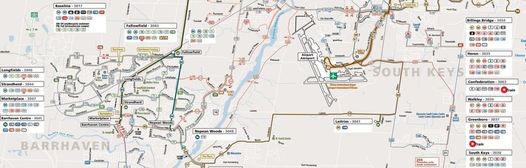
1 APPENDIX A OC Transpo Maps & Route Information
2
3 OC Transpo Route 99
4 APPENDIX B Traffic Count Information & Collision Data
5
6
7
8
9
10 VEHICULAR TURNING MOVEMENTS (15 Min. Volumes) Limebank Road & Spratt Road Survey Date: Saturday February 8, 214 Total Observed U-Turns Job No.:13121 Westbound: Southbound: Weather: Cloudy, -11 C Eastbound: Northbound: Recorded: DC, MC Spratt Road Limebank Road WESTBOUND EASTBOUND NORTHBOUND SOUTHBOUND SUB SUB STR SUB SUB STR GRAND LT ST RT TOT LT ST RT TOT TOT LT ST RT TOT LT ST RT TOT TOT TOTAL Time Period 11:-11: :15-11: :3-11: :45-12: :-12: :15-12: :3-12: :45-1: :-1: :15-1: :3-1: :45-2: :-2: :15-2: :3-2: :45-3: :-3: :15-3: :3-3: :45-4: Novatech Engineering Consultants Ltd.
11 City of Ottawa 11 Laurier Ave West Ottawa, Ontario, Canada K1P 1J Count Name: Earl Armstrong and Limebank (Sat) Feb Site Code: Start Date: 2/22/214 Page No: 6 Southbound St. [N] Out In Total R T L U P 1 1 U 3 3 R Eastbound St. [W] Total In Out L T R Peak Hour Data 2/22/214 1:15 PM Ending At 2/22/214 2:15 PM Car Truck Pedal Bike (Road) Ped T L U Out In Total Westbound St. [E] P P U L T R P Out In Total Northbound St. [S] Turning Movement Peak Hour Data Plot (1:15 PM)

12 Suite 2 24 Michael Cowpland Drive Kanata ON, K2M 1P6 Weather: Sunny, Clear Serial Number: T Collected By: Notes: File Name : Earl Armstrong & Canyon Walk Site Code : Start Date : 8/2/214 Page No : 3 Canyon Walk Drive Southbound Earl Armstrong Road Westbound Earl Armstrong Road Eastbound Start Time Right Left Peds App. Total Right Thru Peds App. Total Thru Left Peds App. Total Int. Total Peak Hour Analysis From 11: AM to 3:45 PM - Peak 1 of 1 Peak Hour for Entire Intersection Begins at 2: PM 2: PM :15 PM :3 PM :45 PM Total Volume % App. Total PHF Canyon Walk Drive Out In Total Right 13 Left 12 Peds Peak Hour Data Earl Armstrong Road Out In Total Left 15 Thru 2 Peds North Peak Hour Begins at 2: PM Passenger Vehicles Light Trucks Heavy Trucks Right Thru Peds Out In Total Earl Armstrong Road
13 Collision Main Detail Summary OnTRAC Reporting System FROM: TO: CANYON WALK DR & EARL ARMSTRONG RD Former Municipality: Gloucester Traffic Control: Traffic signal Number of Collisions: 1 COLLISION IMPACT SURFACE VEHICLE DRIVER No. ID DATE DAY TIME ENV LIGHT TYPE CLASS DIR COND'N MANOEUVRE VEHICLE TYPE FIRST EVENT ACTION PED Fri 8: Clear Daylight Other P.D. only V1 N Wet Reversing Pick-up truck Other motor vehicle V2 S Wet Stopped Passenger van Other motor vehicle EARL ARMSTRONG RD S & LIMEBANK RD Former Municipality: Gloucester Traffic Control: Stop sign Number of Collisions: 2 COLLISION IMPACT SURFACE VEHICLE DRIVER No. ID DATE DAY TIME ENV LIGHT TYPE CLASS DIR COND'N MANOEUVRE VEHICLE TYPE FIRST EVENT ACTION PED Sun 19:25 Clear Dark Sideswipe P.D. only V1 S Dry Going ahead Automobile, station Other motor vehicle V2 S Dry Overtaking Passenger van Other motor vehicle Thu 15:11 Clear Daylight Single vehicle P.D. only V1 E Dry Turning right Automobile, station Curb LIMEBANK RD & SPRATT RD Former Municipality: Gloucester Traffic Control: Traffic signal Number of Collisions: 6 COLLISION IMPACT SURFACE VEHICLE DRIVER No. ID DATE DAY TIME ENV LIGHT TYPE CLASS DIR COND'N MANOEUVRE VEHICLE TYPE FIRST EVENT ACTION PED Tue 16:58 Rain Daylight Turning P.D. only V1 W Wet Going ahead Pick-up truck Other motor vehicle V2 E Wet Turning left Automobile, station Other motor vehicle We 7:57 Clear Daylight Rear end Non-fatal V1 E Dry Turning left Automobile, station Other motor vehicle V2 E Dry Turning left Automobile, station Other motor vehicle Tue 7:23 Clear Daylight Rear end P.D. only V1 E Dry Going ahead Automobile, station Other motor vehicle V2 E Dry Turning left Automobile, station Other motor vehicle (Note: Time of Day = ":" represents unknown collision time Tuesday, April 8, 214 Page 1 of 2
14 Collision Main Detail Summary OnTRAC Reporting System FROM: TO: We 2:45 Snow Dark Other Non-fatal V1 S Packed snow Turning right Pick-up truck Skidding/Sliding V2 E Packed snow Going ahead Automobile, station Other motor vehicle Tue 17:45 Rain Dark Rear end P.D. only V1 S Wet Going ahead Automobile, station Other motor vehicle V2 S Wet Stopped Automobile, station Other motor vehicle Sun 3:9 Clear Dark Single vehicle P.D. only V1 E Ice Going ahead Automobile, station Ran off road (Note: Time of Day = ":" represents unknown collision time Tuesday, April 8, 214 Page 2 of 2
Kansas City Missouri Public Works 414 East 12th Street Kansas City, Mo
 Page No : 1 Groups Printed- Unshifted Southbound Westbound Northbound Eastbound Start Time Peds App. Total Peds App. Total Peds App. Total Peds App. Total Exclu. Total Inclu. Total Int. Total 07:00 AM
Figure 1 Map of intersection of SR 44 (Ravenna Rd) and Butternut Rd
 and Butternut Rd") Abbreviated Study District: 12 County: Geauga Route: SR 44 Section: 1.58 GEA 44 1.58 213 HSP # 47 (Rural Intersection) Prepared April 23, 215 By Bryan Emery Existing Conditions This study contains the
Abbreviated Study District: 12 County: Geauga Route: SR 44 Section: 1.58 GEA 44 1.58 213 HSP # 47 (Rural Intersection) Prepared April 23, 215 By Bryan Emery Existing Conditions This study contains the
Trim Road, Commercial Development, City of Ottawa
 HARDEN REALTIES July 2016 Trim Road, Commercial Development, City of Ottawa Transportation Impact Study Trim Road, Commercial Development, City of Ottawa Transportation Impact Study prepared for: Harden
Start Time. LOCATION: Scotts Valley Dr QC JOB #: SPECIFIC LOCATION: 0 ft from Tabor St. DIRECTION: EB/WB CITY/STATE: Scotts Valley, CA
 Tube Counts Type of report: Tube Count - Volume Data LOCATION: Scotts Valley Dr QC JOB #: 245667 SPECIFIC LOCATION: ft from Tabor St DIRECTION: EB/WB CITY/STATE: Scotts Valley, CA DATE: Mar 2 24 - Mar
770 SOMERSET STREET RESIDENTIAL DEVELOPMENT
 Downtown North York by PFHLai / CC-BY-3. September 217 77 SOMERSET STREET RESIDENTIAL DEVELOPMENT Transportation Impact Assessment 77 Somerset Street Residential Development Transportation Impact Assessment
Study Area and Location District PSA Ward ANC Phase Description C Planned Suitland Parkway Westbound at Stanton Road Southeast
 Speed Limit and Safety Nexus Studies for Automated Enforcement Locations in the District of Columbia Suitland Parkway at Stanton Road SE Study Area and Location District PSA Ward ANC Phase Description
Lacey Gateway Residential Phase 1
 Lacey Gateway Residential Phase Transportation Impact Study April 23, 203 Prepared for: Gateway 850 LLC 5 Lake Bellevue Drive Suite 02 Bellevue, WA 98005 Prepared by: TENW Transportation Engineering West
Traffic Accident Statistics
 2000 Missouri State Highway System Traffic Accident Statistics Missouri State Highway System Traffic Accident Statistics Table of Contents Subject Chapter 1: Statewide Traffic Accident Statistics, Introduction
MEMO VIA . Ms. Amy Roth DPS Director, City of Three Rivers. To:
 MEMO To: Ms. Amy Roth DPS Director, City of Three Rivers VIA EMAIL From: Michael J. Labadie, PE Julie M. Kroll, PE, PTOE Brandon Hayes, PE, P.Eng. Fleis & VandenBrink Date: January 5, 2017 Re: Proposed
1999 Missouri State Highway System. Missouri Department of Transportation - Transportation Management Systems
 1999 Missouri State Highway System Traffic Accident Statistics - Transportation Management Systems Missouri State Highway System Traffic Accident Statistics Table of Contents Subject Chapter 1: Statewide
USE RESTRICTED 23 USC 409
 Study Map & Totals Legend Fatality Injury Property Damage Remarks: NONE Date Range: 01-01-2010 thru 12-31-2014 2010 2011 2012 Fat Incap Inj Non-Incap Inj Poss Inj PD Tot Fat Incap Inj Non-Incap Inj Poss
Study Area and Location District PSA Ward ANC Phase Description C Existing 100 Block Michigan Avenue Northeast Westbound
 Speed Limit and Safety Nexus Studies for Automated Enforcement Locations in the District of Columbia 1 Block Michigan Avenue NE W/B Study Area and Location District PSA Ward ANC Phase Description 5 45
USE RESTRICTED 23 USC 409
 Created: 04/29/2016 by Randy Woods Study Map & Totals Legend Fatality Injury Property Damage Remarks: NONE Date Range: 01-01-2006 thru 12-31-2015 2006 2007 2008 Fat Incap Inj Non-Incap Inj Poss Inj PD
Study Area and Location District PSA Ward ANC Phase Description C Proposed 2600 Block Lincoln Road Northeast Northbound
 Speed Limit and Safety Nexus Studies for Automated Enforcement Locations in the District of Columbia 2600 Block Lincoln Road NE Study Area and Location District PSA Ward ANC Phase Description 5 502 5 5C
RICHMOND OAKS HEALTH CENTRE 6265 PERTH STREET OTTAWA, ONTARIO TRANSPORTATION BRIEF. Prepared for: Guycoki (Eastern) Limited.
 Limited.") RICHMOND OAKS HEALTH CENTRE 6265 PERTH STREET OTTAWA, ONTARIO TRANSPORTATION BRIEF Prepared for: Guycoki (Eastern) Limited June 16, 2016 116-638 Brief_1.doc D. J. Halpenny & Associates Ltd. Consulting
RICHMOND OAKS HEALTH CENTRE 6265 PERTH STREET OTTAWA, ONTARIO TRANSPORTATION BRIEF Prepared for: Guycoki (Eastern) Limited June 16, 2016 116-638 Brief_1.doc D. J. Halpenny & Associates Ltd. Consulting
Speed Limit and Safety Nexus Studies for Automated Enforcement Locations in the District of Columbia 3rd Street Tunnel at Massachusetts Avenue Exit
 Speed Limit and Safety Nexus Studies for Automated Enforcement Locations in the District of Columbia 3rd Street Tunnel at Massachusetts Avenue Exit Study Area and Location District PSA Ward ANC Phase Description
Study Area and Location District PSA Ward ANC Phase Description A Proposed Monroe Street Northeast Eastbound at Rhode Island Avenue
 Speed Limit and Safety Nexus Studies for Automated Enforcement Locations in the District of Columbia Monroe Street NE and Rhode Island Avenue NE Study Area and Location District PSA Ward ANC Phase Description
Speed Limit and Safety Nexus Studies for Automated Enforcement Locations in the District of Columbia 400 Block 14th Street SW
 Speed Limit and Safety Nexus Studies for Automated Enforcement Locations in the District of Columbia 4 Block 4th Street SW Study Area and Location District PSA Ward ANC Phase Description 27 6 6D Existing
Study Area and Location District PSA Ward ANC Phase Description B Existing 3700 Block Massachusetts Avenue Southeast Southeast-bound
 Speed Limit and Safety Nexus Studies for Automated Enforcement Locations in the District of Columbia 37 Block Massachusetts Avenue SE Study Area and Location District PSA Ward ANC Phase Description 6 65
MERIVALE PRIORITY SQUARE 2852 MERIVALE ROAD CITY OF OTTAWA TRANSPORTATION BRIEF. Prepared for: ONT Inc. 25 Winding Way Nepean, Ontario K2C 3H1
 MERIVALE PRIORITY SQUARE 2852 MERIVALE ROAD CITY OF OTTAWA TRANSPORTATION BRIEF Prepared for: 2190986ONT Inc. 25 Winding Way Nepean, Ontario K2C 3H1 October 6, 2010 110-502 Report_1.doc D. J. Halpenny
Traffic Analysis for Bon Air Bridge Mitigation Magnolia Storm Water Quality Project
 Memo To: Paul DiDonato, ATI Architects and Engineers From: David Parisi, PE and Ashley Tam, EIT Date: February 23, 216 Subject: Traffic Analysis for Bon Air Bridge Mitigation Magnolia Storm Water Quality
Study Area and Location District PSA Ward ANC Phase Description B Existing 600 Block New York Avenue Northeast Westbound
 Speed Limit and Safety Nexus Studies for Automated Enforcement Locations in the District of Columbia 6 Block New York Avenue NE Study Area and Location District PSA Ward ANC Phase Description 5 55 5 5B
USE RESTRICTED 23 USC 409
 Created: 06/29/2018 by Lora Koetsier Study Map & Totals Legend Fatality Injury Property Damage Remarks: REQUEST FROM SHELBY TEMPLIN IN SAPM ON 29 JUNE 2018 Date Range: 10-03-2012 thru 10-02-2017 2012 2013
McArthur Avenue Cycling Lanes (between St. Laurent Boulevard and North River Road)
") Transportation Services McArthur Avenue Cycling Lanes (between St. Laurent Boulevard and North River Road) Voies cyclables de l avenue McArthur (du boulevard St-Laurent au chemin North River) Open House
Transportation Services McArthur Avenue Cycling Lanes (between St. Laurent Boulevard and North River Road) Voies cyclables de l avenue McArthur (du boulevard St-Laurent au chemin North River) Open House
Bennett Pit. Traffic Impact Study. J&T Consulting, Inc. Weld County, Colorado. March 3, 2017
 Bennett Pit Traffic Impact Study J&T Consulting, Inc. Weld County, Colorado March 3, 217 Prepared By: Sustainable Traffic Solutions, Inc. http://www.sustainabletrafficsolutions.com/ Joseph L. Henderson,
City of Madison, WI Crash Report
 City of Madison, WI 2010 Crash Report Traffic Engineering and Parking Divisions David C. Dryer, P.E., City Traffic Engineer and Parking Manager Suite 100 215 Martin Luther King, Jr. Boulevard P.O. Box
CDMS - Crash Data Management System. Crash Data Report. Report Memo: RESERVE FOR MAP SCREENSHOT
 Report Memo: 213-217 RESERVE FOR MAP SCREENSHOT Intersection Summary Top 4 Report 15_2924 15_286 15_7359 15_595 15_22194 15_22158 15_12873 15_17926 15_2279 15_19276 15_1615 15_3128 15_17273 15_26238 15_19328
TRAFFIC IMPACT ANALYSIS FOR THE 630/650 SOUTH STREET RETAIL DEVELOPMENT WRENTHAM, MASSACHUSETTS
 PARE PROJECT NO. 17120.00 REPORT TRAFFIC IMPACT ANALYSIS FOR THE 630/650 SOUTH STREET RETAIL DEVELOPMENT WRENTHAM, MASSACHUSETTS SUBMITTED TO: GEORGETOWN CAPITAL MANAGEMENT PO BOX 369 GEORGETOWN, MA 01833
Driving Safely in Maryland
 Maryland Department of Transportation State Highway Administration Office of Traffic and Safety Driving Safely in Maryland In 2008, there were 141 fatal speeding crashes, accounting for 28% of all fatal
ROUTE 23 SUSSEX BOROUGH REALIGNMENT AND PAPAKATING CREEK BRIDGE REPLACEMENT TRAFFIC STUDY. January 20, 2009
 ROUTE 23 SUSSEX BOROUGH REALIGNMENT AND PAPAKATING CREEK BRIDGE REPLACEMENT TRAFFIC STUDY January 20, 2009 Submitted to: New Jersey Department of Transportation Submitted by: PB AMERICAS, INC. Table of
BARRHAVEN FELLOWSHIP CRC 3058 JOCKVALE ROAD OTTAWA, ONTARIO TRANSPORTATION BRIEF. Prepared for:
 BARRHAVEN FELLOWSHIP CRC 3058 JOCKVALE ROAD OTTAWA, ONTARIO TRANSPORTATION BRIEF Prepared for: Barrhaven Fellowship CRC 3058 Jockvale Road Ottawa, ON K2J 2W7 December 7, 2016 116-649 Report_1.doc D. J.
LAWRENCE TRANSIT CENTER LOCATION ANALYSIS 9 TH STREET & ROCKLEDGE ROAD / 21 ST STREET & IOWA STREET LAWRENCE, KANSAS
 LAWRENCE TRANSIT CENTER LOCATION ANALYSIS 9 TH STREET & ROCKLEDGE ROAD / 21 ST STREET & IOWA STREET LAWRENCE, KANSAS TRAFFIC IMPACT STUDY FEBRUARY 214 OA Project No. 213-542 TABLE OF CONTENTS 1. INTRODUCTION...
King Street & Wyman Road Transportation Impact Study & Transportation Demand Management. Paradigm Transportation Solutions Limited
 King Street & Wyman Road Transportation Impact Study & Transportation Demand Management Paradigm Transportation Solutions Limited April 28 Project Summary Project Number 822 April 28 Client RISE Commercial
INTERSECTION ANALYSIS PARK AVENUE AND BRADDOCK ROAD (FROSTBURG, MD) FOR LENHART TRAFFIC CONSULTING, INC.
 FOR LENHART TRAFFIC CONSULTING, INC.") INTERSECTION ANALYSIS FOR PARK AVENUE AND BRADDOCK ROAD (FROSTBURG, MD) Prepared for: City of Frostburg, Maryland & Allegany County Commissioners Prepared by: LENHART TRAFFIC CONSULTING, INC. TRAFFIC ENGINEERING
INTERSECTION ANALYSIS FOR PARK AVENUE AND BRADDOCK ROAD (FROSTBURG, MD) Prepared for: City of Frostburg, Maryland & Allegany County Commissioners Prepared by: LENHART TRAFFIC CONSULTING, INC. TRAFFIC ENGINEERING
Speed Limit and Safety Nexus Studies for Automated Enforcement Locations in the District of Columbia 3600 Block Martin Luther King, Jr.
 Speed Limit and Safety Nexus Studies for Automated Enforcement Locations in the District of Columbia 36 Block Martin Luther King, Jr. Avenue SE Study Area and Location District PSA Ward ANC Phase Description
December 5, Red Bank Planning Board Municipal Building 90 Monmouth Street Red Bank, NJ 07701
 Dynamic Traffic, LLC www.dynamic-traffic.com 1904 Main Street Lake Como, NJ 07719 T. 732.681.0760 December 5, 2016 Red Bank Planning Board Municipal Building 90 Monmouth Street Red Bank, NJ 07701 Re: Traffic
Existing Traffic Conditions
 May 14, 2014 Ms. Lorraine Weiss City of San Mateo 330 West 20 th Avenue San Mateo, CA 94403 Subject: Traffic Operational Study for the Proposed Tilton Avenue Residential Development in San Mateo, California
M:\2016\116048\DATA\REPORTS\TRAFFIC\ TRANSPORTATION OVERVIEW.DOCX
 December 15 th, 2016 City of Ottawa Planning and Growth Management Branch 110 Laurier Avenue West, 4 th Floor Ottawa, ON K1P 1J1 Attention: Mr. Wally Dubyk, C.E.T. Project Manager, Infrastructure Approvals
Appendix C-5: Proposed Refinements Rail Operations and Maintenance Facility (ROMF) Traffic Impact Analysis. Durham-Orange Light Rail Transit Project
 Traffic Impact Analysis. Durham-Orange Light Rail Transit Project") Appendix C-5: Proposed Refinements Rail Operations and Maintenance Facility (ROMF) Traffic Impact Analysis Durham-Orange Light Rail Transit Project July 25, 218 ROMF Transportation Impact Analysis Version
Appendix C-5: Proposed Refinements Rail Operations and Maintenance Facility (ROMF) Traffic Impact Analysis Durham-Orange Light Rail Transit Project July 25, 218 ROMF Transportation Impact Analysis Version
DEVELOPMENT PROPERTY 1627 MAXIME STREET CITY OF OTTAWA TRANSPORTATION OVERVIEW. Prepared for: Subhas Bhargava. July 9, Overview_1.
 DEVELOPMENT PROPERTY 1627 MAXIME STREET CITY OF OTTAWA TRANSPORTATION OVERVIEW Prepared for: Subhas Bhargava July 9, 2015 115-620 Overview_1.doc D. J. Halpenny & Associates Ltd. Consulting Transportation
W District Department of Transportation 55 M Street, SE, Suite 400 Washington, DC 20003
 Speed Limit and Safety Nexus Studies for Automated Enforcement Locations in the District of Columbia 35 Block Martin Luther King, Jr. Avenue SE SW/B Study Area and Location District PSA Ward ANC Phase
Memorandum. To: Sue Polka, City Engineer, City of Arden Hills. From: Sean Delmore, PE, PTOE. Date: June 21, 2017
 Memorandum engineering planning environmental construction 701 Xenia Avenue South Suite 300 Minneapolis, MN 55416 Tel: 763-541-4800 Fax: 763-541-1700 To: Sue Polka, City Engineer, City of Arden Hills From:
DLZ OHIO, US 322 #10 ODOT SAFETY ANALYST 2010 REPORT OCTOBER 2012
 DLZ OHIO, INC. CUY-322-13.60-14.20 SAFETY STUDY US 322 #10 ODOT SAFETY ANALYST 2010 REPORT OCTOBER 2012 Cuyahoga Study Location Prepared for: The Ohio Department of Transportation District 12 5500 Transportation
GASOLINE SERVICE STATION 1618, 1622 ROGER STEVENS DRIVE OTTAWA, ONTARIO TRANSPORTATION IMPACT ASSESSMENT. Prepared for:
 GASOLINE SERVICE STATION 1618, 1622 ROGER STEVENS DRIVE OTTAWA, ONTARIO TRANSPORTATION IMPACT ASSESSMENT Prepared for: Invecta Development (Ottawa) Corporation 758 Shanks Height Milton, ON L9T 7P7 May
Traffic Impact Study Speedway Gas Station Redevelopment
 Traffic Impact Study Speedway Gas Station Redevelopment Warrenville, Illinois Prepared For: Prepared By: April 11, 2018 Table of Contents 1. Introduction... 1 2. Existing Conditions... 4 Site Location...
CC SUPPORTING DOC PDF POMEROY-CENTRAL AWS REPORT W-EXHIBIT A.PDF POMEROY-ELM SWA REPORT W-EXHIBITS.PDF
 1. Agenda Documents: AGENDA.03.06.2018.PDF 2. Supporting Documentation Documents: CC SUPPORTING DOC. 2018.03.06.PDF POMEROY-CENTRAL AWS REPORT W-EXHIBIT A.PDF POMEROY-ELM SWA REPORT W-EXHIBITS.PDF COMMON
Buffalo Drive Road Safety Audit
 UPWP Task 6410-11 Contract No: 11-050 Buffalo Drive Road Safety Audit CC 215 to Blue Diamond Road (SR 160) PRE CONSTRUCTION PHASE AUDIT Prepared for: Regional Transportation Commission of Southern Nevada
TRAFFIC SIGNAL DESIGN REPORT KING OF PRUSSIA ROAD & RAIDER ROAD RADNOR TOWNSHIP PENNSYLVANIA
 TRAFFIC SIGNAL DESIGN REPORT KING OF PRUSSIA ROAD & RAIDER ROAD RADNOR TOWNSHIP PENNSYLVANIA PREPARED FOR: UNIVERSITY OF PENNSYLVANIA HEALTH SYSTEM 34 CIVIC CENTER BOULEVARD PHILADELPHIA, PA 1987 (61)
Collision Analysis Safety Tables
 Crash Severity Geography of Geography of Time and Date of Crash Conditions Features Features.. Queries Selected: Town(Hartford), Date(Year:All or //05 to 9/7/06), Severity(All), Route Class(Interstate),
TRANSPORTATION REVIEW
 TRANSPORTATION REVIEW - PROPOSED MIX OF LAND USES IS CONSISTENT WITH THE CITY S UNDER THE GRANVILLE BRIDGE POLICIES THAT AIM TO MEET NEIGHBOURING RESIDENTS SHOPPING NEEDS AND REDUCE RELIANCE ON AUTOMOBILE
886 March Road McDonald's Transportation Study
 McDonald's Restaurants of Canada Limited March 2013 886 March Road McDonald's Transportation Study Submitted by: HDR Corporation 100 York Boulevard, Suite 300 Richmond Hill, ON L4B 1J8 (905) 882-4100 www.hdrinc.com
Sugarland Crossing Gwinnett County, Georgia
 Sugarland Crossing Gwinnett County, Georgia S IGNAL W ARRANT A NALYSIS For the Intersection of: Sugarloaf Parkway / Richards Middle School Driveway / Sugarland Crossing Main Site Driveway Prepared for:
County State Aid Highway 30 (Diffley Road) and Dodd Road Intersection Study
 and Dodd Road Intersection Study") County State Aid Highway 30 (Diffley Road) and Dodd Road Intersection Study City of Eagan, Dakota County, Minnesota Date: March 2012 Project No. 14957.000 444 Cedar Street, Suite 1500 Saint Paul, MN 55101
County State Aid Highway 30 (Diffley Road) and Dodd Road Intersection Study City of Eagan, Dakota County, Minnesota Date: March 2012 Project No. 14957.000 444 Cedar Street, Suite 1500 Saint Paul, MN 55101
ROAD SAFETY AUDIT. Main St. (U.S. Route 7, Routes 23 & 41) at South Main St. (U.S. Route 7) and Maple Ave. (Routes 23 & 41) MassDOT Project #607756
 at South Main St. (U.S. Route 7) and Maple Ave. (Routes 23 & 41) MassDOT Project #607756") ROAD SAFETY AUDIT Main St. (U.S. Route 7, Routes 23 & 41) at South Main St. (U.S. Route 7) and Maple Ave. (Routes 23 & 41) MassDOT Project #607756 Town of Great Barrington August 13, 2015 Prepared For:
ROAD SAFETY AUDIT Main St. (U.S. Route 7, Routes 23 & 41) at South Main St. (U.S. Route 7) and Maple Ave. (Routes 23 & 41) MassDOT Project #607756 Town of Great Barrington August 13, 2015 Prepared For:
VEHICLE NO.1- Your Vehicle. Began From. License Plate # (Street, Highway, Mile Marker, Terminal or Other Landmark) Near At VEHICLE NO.2.
 Near At VEHICLE NO.2.") Bates College Automobile Accident Report Please notify Security immediately after an incident. Complete and submit this report within 24 hours of the accident to Adam Mayo in Security. Please fill out
Bates College Automobile Accident Report Please notify Security immediately after an incident. Complete and submit this report within 24 hours of the accident to Adam Mayo in Security. Please fill out
Transportation Safety Technical Report Oregon Department of Transportation. Appendix C. Detailed Study Intersection Crash Evaluation
 Transportation Safety Technical Report Oregon Department of Transportation Appendix C. Detailed Study Intersection Crash Evaluation Transportation Safety Technical Report Oregon Department of Transportation
Proposed Inn at Bellefield Traffic Impact Assessment
 Proposed Inn at Bellefield Traffic Impact Assessment Town of Hyde Park Dutchess County, New York Prepared for: T-Rex Hyde Park Owner LLC 500 Mamroneck Avenue, Suite 300 Harrison, NY 10528 June 21, 2017
One Harbor Point Residential
 Residential Gig Harbor, WA Transportation Impact Analysis January 23, 2017 Prepared for: Neil Walter Company PO Box 2181 Tacoma, WA 98401 Prepared by: TENW Transportation Engineering NorthWest 11400 SE
Traffic Engineering Study
 Traffic Engineering Study Bellaire Boulevard Prepared For: International Management District Technical Services, Inc. Texas Registered Engineering Firm F-3580 November 2009 Executive Summary has been requested
1 st Street Intersection Study
 TRAFFIC ENGINEERING ASSISTANCE PROGRAM 1 st Street Intersection Study Prepared for: City of Independence In Cooperation With: Iowa Department of Transportation & Iowa Department of Public Safety Governor
IV. REVISIONS TO THE DRAFT IS/MND
 IV. REVISIONS TO THE DRAFT IS/MND 1. REVISIONS TO THE DRAFT IS/MND This section presents corrections and clarifications that have been made to the text of the Draft IS/MND. These changes include revisions
1 TO 2 2 TO 3 12 TO 1 10 TO TO 12
 STATION: New York State Department of Transportation Traffic Count Hourly Report Page of ROUTE #: NY ROAD NAME: FROM: RT CENTRAL SQUARE : ACC RT I COUNTY: Oswego : Northbound FACR GROUP: REC. SERIAL #:
Speed Limit Study: Traffic Engineering Report
 Speed Limit Study: Traffic Engineering Report This report documents the engineering and traffic investigation required by Vermont Statutes Annotated Title 23, Chapter 13 1007 for a municipal legislative
Traffic Impact Study for the proposed. Town of Allegany, New York. August Project No Prepared For:
 Appendix B SRF Traffic Study (Revised November 2005) Draft Environmental Impact Statement University Commons Town of Allegany, Cattaraugus County, NY December 2005 Traffic Impact Study for the proposed
Re: Cyrville Road Car Dealership
 1223 Michael Street, Suite 100, Ottawa, ON K1J 7T2 Tel: 613.738.4160 Fax: 613.739.7105 www.delcan.com February 25, 2013 OUR REF: TO3098TOE Mark Motors of Ottawa 611 Montreal Road Ottawa, ON K1K 0T8 Attention:
Study Area and Location District PSA Ward ANC Phase Description B Existing 2200 Block South Dakota Avenue Northeast Southeast bound
 Speed Limit and Safety Nexus Studies for Automated Enforcement Locations in the District of Columbia 22 Block South Dakota Avenue NE Study Area and Location District PSA Ward ANC Phase Description 5 53
1012 & 1024 McGarry Terrace
 December 217 112 & 124 McGarry Terrace Transportation Impact Study 112 & 124 McGarry Terrace Transportation Impact Study prepared for: Lépine Corporation 32 March Road Kanata, ON K2K 2E3 prepared by: 1223
Proposed CVS/pharmacy
 Traffic Impact and Access Study Proposed CVS/pharmacy West Main Street (Route 1) at Hull Street Clinton, Connecticut PREPARED FOR Arista Development LLC 520 Providence Highway, Suite 9 Norwood, Massachusetts
Qualitative Assessment US 1 at Old Dixie Highway 1
 Qualitative Assessment US 1 at Old Dixie Highway 1 Project Location Map NOT TO SCALE US 1 at Old Dixie Highway LEGEND STUDY INTERSECTION Feature Summary of Existing Conditions Description Main Street US
MEDICAL COUNCIL OF CANADA 1021 THOMAS SPRATT PLACE TRANSPORTATION BRIEF
 MEDICAL COUNCIL OF CANADA 121 THOMAS SPRATT PLACE TRANSPORTATION BRIEF Prepared By: NOVATECH Suite 2, 24 Michael Cowpland Drive Ottawa, Ontario K2M 1P6 November 214 Novatech File: 113212 Reference No.
Lane Closure Manual. Route Report Index: US12-A US12-03 (WB) US12-01 (EB WB) US12-02 (EB)
 US12-01 (EB WB) US12-02 (EB)") Route Report Index: US1-A?A@ 15 %&'( 94?A@ 5?A@?A@ 95 +, 16 9?A@?A@ 47 %&'( 95 5?A@ 65 +, 8 +, 1 5 %&'( 94 %&'( 69 4 %&'( 5 W %&'( 5 E +, 61?A@ 95 %&'( %&'( 69 4 9 4 %&'( 94 %&'( 49 4 NOTE: Lane closures
Route Report Index: US1-A?A@ 15 %&'( 94?A@ 5?A@?A@ 95 +, 16 9?A@?A@ 47 %&'( 95 5?A@ 65 +, 8 +, 1 5 %&'( 94 %&'( 69 4 %&'( 5 W %&'( 5 E +, 61?A@ 95 %&'( %&'( 69 4 9 4 %&'( 94 %&'( 49 4 NOTE: Lane closures
ARVADA TRIANGLE REDEVELOPMENT TRAFFIC IMPACT ANALYSIS
 ARVADA TRIANGLE REDEVELOPMENT TRAFFIC IMPACT ANALYSIS Prepared for: Arvada Urban Renewal Authority 5601 Olde Wadsworth Boulevard, Suite 210 Arvada, Colorado 80002 (720) 898-7062 Prepared by: Felsburg Holt
VEHICLE / PEDESTRIAN COLLISIONS
 Info item No. 1 Crosswalk Safety Advisory Committee March 31, 2016 VEHICLE / PEDESTRIAN COLLISIONS HRM: January December 20 DISCLAIMER: All figures presented in this report reflect the information held
Intersection Control Evaluation
 Intersection Control Evaluation Stoltzman Road at Pleasant Street in Mankato, Blue Earth County, Minnesota Mankato/North Mankato Area Planning Organization October 2017 SRF No. 10279 Table of Contents
1 TO 2 2 TO 3 3 TO 4 11 TO TO 1
 STATION: New York State Department of Transportation Traffic Count Hourly Report Page of ROUTE #: NY ROAD NAME: FROM: RT : END / OLAP COUNTY: Onondaga : Eastbound FACR GROUP: REC. SERIAL #: AP FUNC. CLASS:
2405 Mer Bleue Orleans, (Ottawa), ON Community Transportation Study Mattamy Homes. Prepared By: Stantec Consulting Ltd. Version 2
, ON Community Transportation Study Mattamy Homes. Prepared By: Stantec Consulting Ltd. Version 2") 2405 Mer Bleue Orleans, (Ottawa), ON Community Transportation Study Mattamy Homes Prepared By: Stantec Consulting Ltd. Version 2 April 2014 Stantec Consulting Ltd. 400-1331 Clyde Avenue, Ottawa ON K2C
2405 Mer Bleue Orleans, (Ottawa), ON Community Transportation Study Mattamy Homes Prepared By: Stantec Consulting Ltd. Version 2 April 2014 Stantec Consulting Ltd. 400-1331 Clyde Avenue, Ottawa ON K2C
KUM & GO 6400 WESTOWN PARKWAY WEST DES MOINES, IOWA 50266
 KUM & GO #300 PECOS STREET & 88 TH AVENUE THORNTON, COLORADO TRAFFIC IMPACT STUDY REVISION 1 PREPARED FOR KUM & GO 6400 WESTOWN PARKWAY WEST DES MOINES, IOWA 50266 JANUARY 23, 2014 OA PROJECT NO. 013-1721
Barrhaven Honda Dealership. Dealership Drive, Ottawa, ON. Transportation Brief
 Barrhaven Honda Dealership Dealership Drive, Ottawa, ON Transportation Brief Prepared By: NOVATECH Suite 200, 240 Michael Cowpland Drive Ottawa, Ontario K2M 1P6 September, 2015 File: 115136 Ref: R-2015-152
Intersection Analysis for US 92/International Speedway Blvd. at Garfield Ave.
 FinalReport IntersectionAnalysisfor US92/InternationalSpeedwayBlvd. atgarfieldave. April2017 Preparedfor: RivertoSeaTransportationPlanningOrganization (R2CTPO) 2570W.InternationalSpeedwayBlvd.,Suite100
Traffic Impact Analysis
 Traffic Impact Analysis Congregate Care Facility Billerica, Massachusetts Prepared For: Hawthorn Development, LLC 35 Kettle Court Salem, OR 973 Prepared By: Sebago Technics, Inc. 75 John Roberts Road,
Re: Residential Development - Ogilvie/Cummings Transportation Overview
 1223 Michael Street, Suite 100, Ottawa, ON K1J 7T2 Tel: 613.738.4160 Fax: 613.739.7105 www.delcan.com March 28, 2012 OUR REF: TO3088TOY Barry J. Hobin & Architects 63 Pamilla Street Ottawa, ON K1S 3K7
US Rt. 12/20/45 at US Rt. 20 <Westbound and Southbound>
 US Rt. 12/20/45 at US Rt. 20 Village of Stone Park, Illinois R L R F o l l o w - U p E v a l u a t i o n R e p o r t Reference No: 016-43280 December 2010 Table of Contents
Per the Illinois Compiled Statutes, 625 ILCS 5/ Automated Traffic Law Enforcement System:
 Per the Illinois Compiled Statutes, 625 ILCS 5/11-208.6 Automated Traffic Law Enforcement System: (k-7) A municipality or county operating an automated traffic law enforcement system shall conduct a statistical
ACCIDENT REVIEW FORM
 ACCIDENT REVIEW FORM American Trucking Associations, Inc. Safety Management Council 950 N. Glebe Road, Suite 210, Arlington, VA 22203-4181 Fax: 703-838-1965 E-Mail: JPierce@trucking.org Members of the
Shirk Road at State Route 198 Interchange Analysis Tulare County, California
 Shirk Road at State Route 198 Interchange Analysis Tulare County, California DRAFT REPORT Prepared By Tulare County Association of Governments (TCAG) April 2013 Table of Contents Introduction:... 3 Project
Technical Memorandum. Purpose of Report and Study Objectives. Summary of Results
 Technical Memorandum To: Derek Leuer, MnDOT Traffic Safety Engineer From: Max Moreland, P.E. and Bryant Ficek, P.E., P.T.O.E. Date: February 17, 217 Re: Median Acceleration Lane Usage Purpose of Report
Winnetka Avenue Bike Lanes Traffic Impact Analysis
 Winnetka Avenue Bike Lanes Traffic Impact Analysis January 4, 2019 Prepared by City of Los Angeles Department of Transportation Active Transportation Division Winnetka Ave Bike Lanes Traffic Impact Analysis
M E M O / N O T E D E S E R V I C E
 M E M O / N O T E D E S E R V I C E To / Destinataire From / Expéditeur Mayor and Members of Council Chair and Members of the Transit Commission General Manager Transportation Services Department File/N
Pedestrians Road Safety
 Pedestrians Road Safety Overview Over the period 1996-2009, 5,323 people have been killed on Irish road. Out of this 22% (1162) were pedestrians. Additional 3863 pedestrians were seriously injured in the
Clean Harbors Canada, Inc.
 Clean Harbors Canada, Inc. Proposed Lambton Landfill Expansion Environmental Assessment Terms of Reference Transportation Assessment St. Clair Township, Ontario September 2009 itrans Consulting Inc. 260
4131 Chain Bridge Road
 Traffic Impact Study 4131 Chain Bridge Road City of Fairfax, VA 05/04/16 May 4, 2016 Prepared for: Paradigm 1415 North Taft Street Suite 100 Arlington, VA 22201 This report is printed on environmentally
2.0 Development Driveways. Movin Out June 2017
 Movin Out June 2017 1.0 Introduction The proposed Movin Out development is a mixed use development in the northeast quadrant of the intersection of West Broadway and Fayette Avenue in the City of Madison.
TIS / TB/ CTS Check List
 Study Merivale Type Road Central Park Mixed-Use Development May 2011 Study TIS/CTS Name February 2011 CTS/TIS Check List TIS / TB/ CTS Check List prepared for: Ashcroft Homes 18 Antares Drive Ottawa, ON
MONTHLY RIDERSHIP AND PERFORMANCE REPORT. August 2018 Monthly Performance Report
 MONTHLY RIDERSHIP AND PERFORMANCE REPORT August 2018 Monthly Performance Report Ridership AUGUST, 2018 MONTHLY PERFORMANCE REPORT Ridership for the month of August decreased 2.6% when compared to August
Wellings Communities Holding Inc and Extendicare (Canada) Inc Hazeldean Road. Transportation Impact Study. Ottawa, Ontario. Project ID
 Inc Hazeldean Road. Transportation Impact Study. Ottawa, Ontario. Project ID") Wellings Communities Holding Inc and Extendicare (Canada) Inc. 5731 Hazeldean Road Transportation Impact Study Ottawa, Ontario Project ID 160401195 Prepared by: Stantec Consulting Ltd. March 2016 WELLINGS
Wellings Communities Holding Inc and Extendicare (Canada) Inc. 5731 Hazeldean Road Transportation Impact Study Ottawa, Ontario Project ID 160401195 Prepared by: Stantec Consulting Ltd. March 2016 WELLINGS
144&176 John St. and 200 John St. & 588 Charlotte St. Hotel and Residential Subdivision Development
 Solmar Development Corp. 144&176 John St. and 2 John St. & 588 Charlotte St. Hotel and Residential Subdivision Development TRANSPORTATION IMPACT STUDY 18145 November 217 LEA Consulting Ltd. Consulting
TRAFFIC IMPACT STUDY FOR ST. JOSEPH'S ELEMENTARY SCHOOL ADDITION
 CATHOLIC DISTRICT SCHOOL BOARD OF EASTERN ONTARIO P.O. 61992 TRAFFIC IMPACT STUDY FOR ST. JOSEPH'S ELEMENTARY SCHOOL ADDITION SEPTEMBER 5, 218 TRAFFIC IMPACT STUDY FOR ST. JOSEPH'S ELEMENTARY SCHOOL ADDITION
Peachtree Streetscape Atlanta, Georgia
 Operational Analysis reetscape Atlanta, Georgia Prepared for: Central Atlanta Progress Prepared by: Kimley-Horn and Associates, Inc. Kimley-Horn and Associates, Inc. November 26 192812 reetscape Operational
Stittsville OC Transpo Services
 Stittsville OC Transpo Services Transportation Services Department March 22, 2018 0 Ottawa s Transit Challenge 1 1 What s Coming in 2018 O-Train Network 2 2 Confederation Line - Alignment 3 3 VEHICLE AND
Submittal Document II.G. D-bar-A Project, Traffic Impact Study, prepared by Bergmman Associates, dated November 3, 2015 ( Traffic Study )
") Submittal Document II.G. D-bar-A Project, Traffic Impact Study, prepared by Bergmman Associates, dated November 3, 2015 ( Traffic Study ) D-bar-A Project Traffic Impact Study November 3 rd, 2015 1427
Submittal Document II.G. D-bar-A Project, Traffic Impact Study, prepared by Bergmman Associates, dated November 3, 2015 ( Traffic Study ) D-bar-A Project Traffic Impact Study November 3 rd, 2015 1427