HIGHWAY ACCESS REGULATION ORDINANCE KENDALL COUNTY ILLINOIS
|
|
|
- Brett Charles
- 6 years ago
- Views:
Transcription
1 HIGHWAY ACCESS REGULATION ORDINANCE KENDALL COUNTY ILLINOIS
2 KENDALL COUNTY HIGHWAY ACCESS REGULATION ORDINANCE Adopted by the KENDALL COUNTY BOARD May 18, 1999 Prepared By: Kendall County Highway Department 6780 Route 47 Yorkville, Illinois Francis C. Klaas, P.E. County Engineer AMENDMENTS (Included Herein) July 18, 2006: November 15, 2005: March 15, 2005: Highway Access Classifications Access Classification Spacing Standards WIKADUKE Trail Issues
3 KENDALL COUNTY Ordinance No An Ordinance Amending the Kendall County Highway Access Regulation Ordinance WHEREAS, access to Kendall County Highways has been regulated by the Kendall County Board via the Kendall County Highway Access Regulation Ordinance, adopted by the Board on May 18, 1999; and WHEREAS, the Kendall County Board continues to endeavor to promote the safe and efficient travel of motorists on Kendall County Highways by evaluating and updating access standards for said Highways from time to time; and WHEREAS, Highway Access Classifications have been evaluated by the County Board in an effort to balance the right of reasonable access with the need to promote the efficient flow of traffic in terms of safety, capacity and speed. THEREFORE, BE IT RESOLVED, that the Kendall County Board hereby amends the Highway Access Classifications of the Kendall County Highway Access Regulation Ordinance, hereby attached as Exhibit 1. Approved by the County Board of Kendall County, State of Illinois. John Church Kendall County Board Chairman I, Paul Anderson, County Clerk in and for said County, in the State aforesaid, and keeper of the records and files thereof, as provided by statute, do hereby certify the foregoing to be a true, perfect and complete copy of an ordinance adopted by the Kendall County Board, at its regularly scheduled meeting in Yorkville, Illinois, on the 18th day of July, A.D., Paul Anderson County Clerk SEAL
4 HIGHWAY ACCESS CLASSIFICATIONS Kendall County Highway Access Regulation Ordinance Revised FACILITY LIMITS CLASSIFICATION Cannonball Trail Ill. Rte. 47 to Galena Rd. Access 5 Caton Farm Road Ill. Rte. 71 (extended west) to Ridge Road Access 1 Chicago Road Plattville Rd. to Grove Rd. Access 4 Eldamain Road Ill. Rte 71 to Galena Rd. Access 2 Fox Road Fox River Drive to Fox Lawn Subdivision Access 3 Fox River Drive Newark to Plano including Crimmins realignment Access 3 Galena Road DeKalb County Line to Orchard Rd. Access 2 Grove Road Grundy County Line to Ill. Rte. 126 Access 1 Grove Road Ill. Rte. 126 to Plainfield Road Access 2 Joliet Road Lisbon Rd. to Ill. Rte. 47 Access 3 Lisbon Road Grundy County Line to Ill. Rte. 71 Access 2 Little Rock Road U.S. Route 34 to Kane County Line Access 2 Millbrook Road Ill. Rte. 71 to Fox River Drive Access 3 Millington Road Fox River Drive to Lions Rd. Access 3 Newark Road Ill. Rte. 71 to Ill. Rte. 47 Access 3 Orchard Road Ill. Rte. 71 to U.S. Route 30 Access 1 Plainfield Road Ill. Rte. 126 to Stewart Rd.(WIKADUKE) Access 1 Plainfield Road Stewart Rd. to Grove Rd. Access 2 Plattville Road Ill. Rte. 47 to Chicago Rd. Access 4 Ridge Road Grundy County Line to Ill. Rte 126 (WIKADUKE) Access 1 Rock Creek Road Sweetbriar St. to Galena Rd. Access 3 Sherrill Road Ashley Rd. to O Brien Rd. Access 3 Townhouse Road U.S. Rte. 52 to Neward Rd. Access 3 Van Emmon Road Yorkville to Ill. Rte. 71 Access 5 Walker Road Ill. Rte. 71 to Ill. Rte. 47 Access 3 Whitewillow Road Ill. Rte. 47 to Grove Rd. Access 3 EXHIBIT 1 S:\Access Ordinance\Classification Exhibit
5 KENDALL COUNTY Ordinance No An Ordinance Amending the Kendall County Highway Access Regulation Ordinance WHEREAS, access to Kendall County Highways has been regulated by the Kendall County Board via the Kendall County Highway Access Regulation Ordinance, adopted by the Board on May 18, 1999; and WHEREAS, the Kendall County Board continues to endeavor to promote the safe and efficient travel of motorists on Kendall County Highways by evaluating and updating access standards for said Highways. THEREFORE, BE IT RESOLVED, that the Kendall County Board hereby amends Article 4.2.1, Exhibit 2 of the Kendall County Access Regulation Ordinance as provided herein. Exhibit 2: Access Classification Spacing Standards Highway Classification Signalized Spacing (Min) Public Streets Unsignalized Spacing (Minimum) Private Access Rt. In / Rt. Out Corner Clearance Lateral Access Access ' 2640' 2640' 500' 300' 300' Access ' 1760' 1320' 500' 300' 200' Access ' 1320' 1000' 400' 200' 150' Access 4 N/A 1000' 500' N/A N/A 150' Access ' 750' 250' N/A 100' 100' Spacing shown is for County Highways with barrier medians. Otherwise only 1 Rt. In / Rt. Out will be allowed between fullaccess intersections. For Rt. In / Rt. Out access only Approved by the County Board of Kendall County, State of Illinois. John Church Kendall County Board Chairman I, Paul Anderson, County Clerk in and for said County, in the State aforesaid, and keeper of the records and files thereof, as provided by statute, do hereby certify the foregoing to be a true, perfect and complete copy of an ordinance adopted by the Kendall County Board, at its regularly scheduled meeting in Yorkville, Illinois, on the 15th day of November, A.D., Paul Anderson County Clerk
6 KENDALL COUNTY Ordinance No An Ordinance Amending the Kendall County Highway Access Regulation Ordinance WHEREAS, access to Kendall County Highways has been regulated by the Kendall County Board via the Kendall County Highway Access Regulation Ordinance, adopted by the Board on May 18, 1999; and WHEREAS, the Kendall County Board continues to endeavor to promote the safe and efficient travel of motorists on Kendall County Highways, including the WIKADUKE Trail, which includes parts of Ridge Road, Plainfield Road, and Stewart Road; and WHEREAS, impending development along the WIKADUKE Trail requires the careful consideration of the Board in matters regarding access, so that the mobility along said route will be maintained, entrepreneurship will be promoted, and safety shall not be compromised. THEREFORE, BE IT RESOLVED, that the Kendall County Board hereby amends the Kendall County Access Regulation Ordinance to include the following access provisions for the WIKADUKE Trail. a. In addition to the full access intersections identified in the WIKADUKE Land Use and Access Management Study, approved by the Kendall County Board on May 18, 2004, full access shall also be allowed ¼ mile north and south of Holt Road, U.S. Route 52, Caton Farm Road, Ill. Route 126, and Collins Road, provided said access directly serves not less than 60 combined acres of commercial zoning on both the east and west side of the WIKADUKE Trail, or 40 acres of commercial zoning on just one side of the Trail. b. A right in / right out / left in access shall be allowed on the WIKADUKE Trail ¼ mile north and ¼ mile south of Black Road, provided this type of access serves not less than 20 acres of commercial zoning immediately adjacent to the access point. c. Only one right in / right out access point shall be allowed on each side of the WIKADUKE Trail between full access intersections. For the purposes of this access standard, a right in / right out / left in access shall be considered a full access. Approved by the County Board of Kendall County, State of Illinois. John Church Kendall County Board Chairman I, Paul Anderson, County Clerk in and for said County, in the State aforesaid, and keeper of the records and files thereof, as provided by statute, do hereby certify the foregoing to be a true, perfect and complete copy of an ordinance adopted by the Kendall County Board, at its regularly scheduled meeting in Yorkville, Illinois, on the 15th day of March, A.D., Paul Anderson County Clerk
7 KENDALL COUNTY RESOLUTION NO Resolution regulating access on highways in the County Highway System WHEREAS, Kendall County and adjacent counties are experiencing rapid growth and development within their boundaries, AND WHEREAS, said growth and development is significantly increasing both intracounty and intercounty vehicle trips, and also requiring additional access to abutting developments, AND WHEREAS, Kendall County Board strives to balance the right of reasonable access with maintaining the overall integrity of the County Highway System as a system of major collectors and freeways designed to preserve the regional flow of traffic in terms of safety, capacity, and speed, THEREFORE, BE IT RESOLVED, that Kendall County Board hereby adopts the Kendall County Highway Access Regulation Ordinance including all policies, provisions standards and specifications as detailed therein. STATE OF ILLINOIS COUNTY OF KENDALL SS I,, County Clerk in and for said County, in the State aforesaid, and keeper of the records and files thereof, as provided by statute, do hereby certify the foregoing to be a true, perfect and complete copy of a resolution adopted by the Kendall County Board, at its regularly scheduled meeting in Yorkville, Illinois, on the day of, A.D., Paul Anderson - County Clerk (Seal) i
8 TABLE OF CONTENTS Page I. BACKGROUND 1.0 Title Intent and Purpose Definitions 1 II. ADMINISTRATIVE PROVISIONS 2.0 Authority Conformance With Plans and Regulations Jurisdiction Nonconforming Access Access Permits Site Plan Requirements Approval Criteria For Denial Costs Variances 12 III. COUNTY HIGHWAY SYSTEM CLASSIFICATION 3.0 On-System Roads Highway Access Classification 13 IV. ACCESS POLICIES AND STANDARDS 4.0 Right-Of-Way Dedication Internal Circulation of Streets Spacing Standards for Access Connections Unsignalized Spacing of Access Connections Signalized Spacing of Access Connections Corner Clearance Sight Distance Requirements Turning Lane Requirements 19 V. DESIGN STANDARDS 5.0 Design Publications Pavement Standards Drainage Standards Access Geometrics 24 VI. ACCESS MANAGEMENT STANDARDS FOR ABUTTING PARCELS 6.0 Joint/Cross Access Frontage and Reverse Frontage Roads Subdivision and Site Development Policies 26 ii
9 VII. ACCESS CONSTRUCTION 7.0 Notification Traffic Control Performance Guarantees Certificates of Insurance 29 VIII. ENACTMENT, REPEALER, INTERPRETATION & SEPARABILITY 8.0 Enactment Repealer and Savings Clause Interpretation and Separability 31 LIST OF EXHIBITS Page Exhibit 1 Highway Classifications 15 Exhibit 2 Access Classification Spacing Standards 16 Exhibit 3 Sight Distance Requirements for Access Connections 18 Exhibit 4 Right Turn Lane Requirements 20 Exhibit 5 Left Turn Lane Requirements 21 Exhibit 6 Access Geometrics 24 Exhibit 7 Kendall County Highway Map 33 Exhibit 7 Application For Access Permit 34 iii
10 I. BACKGROUND 1.0 Title This ordinance shall be known as the Kendall County Highway Access Regulation Ordinance. 1.1 Intent and Purpose The intent of this ordinance is to provide and manage access to land development, while preserving the regional flow of traffic in terms of safety, capacity and speed. Major thoroughfares, including routes on the County Highway System and other proposed facilities on the local system, serve as the primary network for moving people and goods. These transportation corridors also provide access to businesses and homes and have served and will continue to serve as the focus for commercial and residential development. If access systems are not properly designed, these thoroughfares will be unable to accommodate the access needs of development and retain their primary transportation function. This ordinance balances the right of reasonable access to private property, with the right of citizens of Kendall County and the State of Illinois to safe and efficient travel. To achieve this policy intent, local thoroughfares have been categorized by function and classified for access purposes based on the level of importance as it applies to the level of regional traffic. Regulations have been applied to these thoroughfares for the purposes of reducing traffic accidents, personal injury, and property damage attributable to poorly designed access systems. The regulations also promote the orderly layout and use of land adjacent to county highways. Finally, these access management measures will protect the substantial public investment in the existing transportation system and reduce the need for expensive remedial measures. 1.2 Definitions AASHTO - The American Association of State Highway and Transportation Officials. Abutting - Having a common border with, or being separated from such common border by an alley or easement. Access - A way or means of approach to provide vehicular or pedestrian entrance or exit to a property. 1
11 Access Classification - A ranking system for roadways used to determine the appropriate degree of access management. Access Management - The process of providing and managing access to land development while preserving the regional flow of traffic in terms of safety, capacity and speed. Access Permit - A permit issued by Kendall County Highway Department providing ingress or egress or both from abutting property along a county highway. Average Daily Traffic (ADT) - The number of vehicles traveling in both directions on a given highway during a 24-hour period as determined by Kendall County Highway Department or Illinois Department of Transportation. Building & Zoning Administrator - The Building and Zoning Administrator of Kendall County. Connection Spacing - The distance between access connections, measured from the closest edge of pavement of the first connection to the closest edge of pavement of the second connection along the edge of the traveled way. Contractor - A person, firm or corporation engaged in construction or landscaping and licensed to do business in the State of Illinois. Corner Clearance - The distance from an intersection of a public or private road to the nearest access connection, measured from the closest edge of pavement of the intersection to the closest edge of pavement of the connection along the edge of the traveled way. County - Kendall County, Illinois County Board - The County Board of Kendall County, Illinois County Engineer - The County Engineer of Kendall County, Illinois County Highway - A public road as defined by the Illinois Highway Code, and part of the County Highway System, including municipal extensions thereof, and any proposed roads as yet unbuilt but designated as part of the County Highway System. Cross Access - A service drive providing vehicular access between 2 or more contiguous sites so that the driver need not enter the public street system. 2
12 Dedication - The transfer of property interests from private to public ownership for a public purpose. The transfer instrument may be of fee-simple interest or of a lesser interest, including easements. Developer - The legal or beneficial owner of a lot or parcel of any land proposed for inclusion in a development, including the holder of an option or contract to purchase. The developer may also be the owner. Easement - A grant of one or more property rights by a property owner to or for the use by the public, or another person or entity. Edge of Pavement (E.O.P.) - Edge of a driving lane of the traveled roadway. Engineer - A registered engineer licensed to practice in the State of Illinois. Field Entrance - Access for agricultural purposes only, but excluding all agricultural business operations, such as tree nurseries. Freeway - A highway designated by the County Board as a freeway in accordance with Article 8 of the Illinois Highway Code. Frontage - The distance, as measured along the highway right-of-way line, between the property lines of the abutting properties. Frontage Road - A public or private drive which generally parallels a public thoroughfare between the right-of-way and the front of the building. IDOT - Illinois Department of Transportation Joint Access (Shared Access) - An access point that connects 2 or more contiguous sites to the public street system. Lateral Access - Access connection onto a road or street that enters or crosses a county highway. Lot - A parcel, tract, or area of land whose boundaries have been established by some legal instrument, which is recognized as a separate legal entity for the purposes of transfer to title, has frontage upon a public or private street, and complies with the dimensional requirements of this code and the Subdivision Control Ordinance of Kendall County. 3
13 Lot, Corner - A lot abutting on 2 or more roads at their juncture. Lot Width - The horizontal distance between side lot lines measured parallel to the front lot line at the minimum required front set back line. Major Use Generator - A land use that generates more than 1500 vehicle trips per day or more than 400 trips in a peak hour, total in both directions. Median Opening - An opening in a restrictive median that allows all turning movements from the roadway and the intersecting road or access connection. Minimum Use Generator - A single family residence or other land use that generates 50 or less vehicle trips per day, and not more than five trips in the peak hour, total in both directions. Minor Use Generator - A land use that generates between 51 and 1500 vehicle trips per day and less than 400 trips in the peak hour, total in both directions. Nonconforming Access Features - Features of the access system of a property that existed prior to the date of ordinance adoption and do not conform with the requirements of this code. Nonrestrictive Median - A median or painted centerline that does not provide a physical barrier between traffic traveling in opposite directions or turning left, including continuous center turn lanes and undivided roads. On System Road - A transportation facility identified in this ordinance in which access is regulated under the terms of this instrument or through an intergovernmental agreement with the appropriate local agency. Peak Hour Volume - The highest hourly vehicular volume observed, or anticipated, at the point of analysis during a normal day. Plat - An exact and detailed map of the subdivision of land. Private Road - Any road or thoroughfare for vehicular travel which is privately owned and maintained and which provides the principal means of access to abutting properties. Public Road - A road under the jurisdiction of a public body that provides the principal means of access to an abutting property. 4
14 Reasonable Access - The minimum number of access connections, direct or indirect, necessary to provide safe access to and from the thoroughfare, as consistent with the purpose and intent of this code and any applicable plans and policies of Kendall County. Recorder - The Recorder of Deeds of Kendall County, Illinois. Restrictive Median - A physical barrier in the roadway that separates traffic traveling in opposite directions, such as a concrete barrier or landscaped island. Right-of-Way - Land reserved, used or to be used for a highway, street, alley, walkway, drainage facility or other public purpose. Sight Distance - The distance at which an object 51" above the centerline of pavement surface can just be seen from a point 42" above the pavement surface. Significant Change in Trip Generation - A change in the use of the property, including land, structure, or facilities, or an expansion of the size of the structures or facilities causing an increase in the trip generation of the property to exceed 25 percent more trips generated (either peak or daily) with at least a 100 vehicles per day increase. Standard Specifications - The most recent edition of the Standard Specifications for Road and Bridge Construction and also included by reference, the most recent editions of the Supplemental Specifications and Recurring Special Provisions, the Standard Specifications for Traffic Control Items, and all amendments and successor documents to the aforementioned documents as published by Illinois Department of Transportation. Stopping Sight Distance - The distance at which an object 6" above the pavement surface can just be seen from a point 42" above the pavement surface. Subdivision - Any division or redivision of a parcel of land into 2 or more parts by means of mapping, platting, conveyance, change or rearrangement of boundaries. Surveyor - An individual registered and licensed as a land surveyor in the State of Illinois. Throat Length - That distance from the edge of pavement of the collector street to the first point of access, circulation, or parking of the development. 5
15 Traffic Impact Study - A comprehensive collection and analysis of all information necessary to accurately evaluate the effect and impact of traffic generated by a development on the current and future highway network surrounding the development. 6
16 II. ADMINISTRATIVE PROVISIONS 2.0 Authority The Illinois Compiled Statutes, as amended, provide for the County Board and the County Engineer to have supervision of County Highways. This ordinance is hereby adopted to provide and manage access to land development, while preserving the regional flow of traffic in terms of safety, capacity and speed ILCS 5/5-413 provides that access roads and driveways for private and public use may, upon receipt of a permit from the County Engineer, be laid out from a County Highway in accordance with regulations adopted by the county board. This ordinance implements that law but does not limit nor restrict the County insofar as other sections of the Illinois Highway Code pertaining to access might apply ILCS 205/2 requires that written approval be obtained from the appropriate local highway authority regarding highway access prior to final approval and recording of a plat. For Kendall County Highways, that authority shall be the County Engineer ILCS 5/8-101 et al grants county boards the authority to designate highways under their jurisdiction as freeways. For highways so designated, the County Board shall have full authority to allow or deny any means or enlarge or extend any existing means of ingress to or egress from abutting land. 2.1 Conformance with Plans and Regulations This ordinance is adopted as a supplement to the Subdivision Control Ordinance and in association with the Kendall County Land Resource Management Plan In addition, this ordinance conforms with the following transportation goals of the Chicago Area Transportation Study and the Northeastern Illinois Planning Commission as outlined in the Destination 2020 Regional Transportation Plan: a) Preserve the region s transportation system and maximize its efficiency for carrying people and goods; 7
17 b) Provide for a transportation system that fosters economic development; c) Provide for the development and preservation of a transportation system which meets the region s transportation needs, efficiently uses financial resources and is financially attainable This ordinance substantially conforms with the planning policies of Illinois Department of Transportation set forth in the Illinois State Transportation Plan, the roadway classification system and standards of IDOT This ordinance also conforms with the policy and planning directives of the Transportation Equity Act for the 21 st Century (TEA-21) which encourages the use of access management techniques as a congestion management strategy. 2.2 Jurisdiction This ordinance shall apply to all vehicular transportation facilities under the jurisdiction of Kendall County as designated in Section III of this document. It shall also apply to those highways and corridors on the local system identified herein, and other facilities as yet unbuilt but identified as regionally significant, insofar as this ordinance is not inconsistent with comprehensive plans of the affected local agencies, and providing the terms and conditions of access are identified in an intergovernmental agreement of the parties involved For County Highways located within corporate limits, the conditions, specifications and requirements of this ordinance shall apply as they relate to those improvements and spacing requirements within the County Highway rights-of-way. Requirements and recommendations for those improvements located outside County Highway rights-of-way shall not apply, unless an intergovernmental agreement between the County and the affected local agency would compel the developer to adhere to the terms of this code. 2.3 Nonconforming Access Permitted access connections in place as of May 18, 1999 that do not conform with the standards herein shall be designated as nonconforming features and shall be brought into compliance with applicable standards under the following conditions: 8
18 a) When new access connection permits are requested; b) Substantial enlargements or improvements in which a 10% increase in existing square footage or 50% increase in assessed valuation of the structure occurs; c) Changes in land use or facilities that create a significant change in trip generations, providing that change is at least 100 vehicles per day If the principal activity on a property with nonconforming access features is discontinued for a consecutive period of 365 days, or discontinued for any period of time without a present intention of resuming that activity, then that property must thereafter be brought into conformity with all applicable connection spacing and design requirements, unless otherwise exempted by the permitting authority. For uses that are vacant or discontinued upon the effective date of this code, the 365 day period begins on the effective date of this code. 2.4 Access Permits An access permit is a legal document granting permission to construct and operate a driveway of a certain basic design at a specific location on a County Highway. The permit, contained herein, is required for the construction of any new access connection or the significant modification of any existing access connection within the right-of-way of a County Highway or on system local street. 2.5 Site Plan Requirements When required by the County Engineer, applicants for an access permit shall submit a preliminary site plan for review by the Kendall County Highway Department. At a minimum, the site plan shall show: a) Location of access point(s) on both sides of the road where applicable; b) Distances to neighboring constructed access points, median openings, traffic signals, intersections, and other transportation features on both sides of the property; c) Number and direction of lanes to be constructed on the access point plus striping plans; 9
19 d) All planned transportation features (such as auxiliary lanes, signals, etc.); e) Trip generation data or appropriate traffic studies, if required by the County Engineer; f) Parking and internal circulation plans; g) Plat map showing property lines, right-of-way and ownership of abutting properties; h) A detailed description of any requested variances and the reason the variance is requested Subdivision and site plan review shall address the following access considerations: a) Is the system designed to meet the projected traffic demand and does the road network consist of hierarchy of roads designed according to function? b) Does the road network follow the natural topography and preserve natural features of the site as much as possible? Have alignments been planned so that grading requirements are minimized? c) Is access properly placed in relation to sight distance, driveway spacing, and other related consideration, including opportunities for joint and cross access? Do access connections line up with access connections on the other side of the street? d) Do residential units front on residential streets rather than major roadways? e) Is automobile movement within the site provided without having to use the peripheral road network? f) Does the road system provide adequate access to buildings for residents, visitors, deliveries, emergency vehicles, and garbage collection? g) Have bicycle and pedestrian facilities been provided at a reasonable and safe distance from the traveled way, preferably outside the county right-ofway? 10
20 2.6 Approval Upon review of the access application, Kendall County Highway Department may approve the access application, approve with conditions, or deny the application. This will be done within 90 days of receiving the complete application If the application is approved with conditions, the applicant shall resubmit the plan with the conditional changes made within 60 days. The plan, with submitted changes, will be reviewed within 30 working days and approved or rejected. Second applications will only be rejected if conditional changes are not made If the access permit is denied, Kendall County Highway Department shall provide an itemized letter detailing why the application was rejected All applicants whose application is approved, or approved with conditions, have thirty days to accept the permit and 12 months to construct all permitted facilities. Applicants whose permits are rejected or approved with conditions have 60 days to appeal. 2.7 Criteria For Denial Direct access to a County Highway shall be denied when a proposed access connection does not meet spacing standards and reasonable access can be provided elsewhere. Reasonable access may include the use of a roadway with a lower classification or a system of joint-use driveways and crossaccess agreements Direct access to a County Highway shall be denied when proposals call for more than one access per property onto a County Highway or contiguous properties with less than the minimum unsignalized spacing requirements as listed in Exhibit 2, and reasonable access can be provided elsewhere. Reasonable access may include the use of a roadway with a lower classification or a system of joint-use driveways and cross-access agreements Direct access to a County Highway shall be denied when a proposed access cannot meet design or safety requirements as outlined herein and in accordance with Illinois Department of Transportation Standards. 11
21 2.8 Costs All costs associated with the construction of a new access, or modification of an existing access, including pavement widening, drainage appurtenances, turning lanes, signal installation or modification, striping, etc., shall be borne by the developer, owner or applicant. Additional traffic impact analyses or safety studies, when required by the County Engineer, shall also be paid for by the developer, owner or applicant. 2.9 Variances The granting of variances shall be in harmony with the purpose and intent of these regulations and shall not be considered until every feasible option for meeting access standards is explored Applicants for a variance from these standards must provide proof of unique or special conditions that make strict applications of the provisions impractical. This shall include proof that: a) Indirect or restricted access cannot be obtained; b) No engineering or construction solutions can be applied to mitigate the condition; c) No alternative access is available from the street with a lower functional classification than the primary roadway, and joint or cross access is not available Applicants shall submit their variance request to the County Engineer within 60 days after the denial of an access permit. The County Engineer shall have the authority to grant variances of up to 15% for the Access Classification Spacing Standards, and other minor variances as necessary. All other variance requests, including denied minor variances, shall come before the County Board. A concurring vote of the majority of the County Board is required to grant these variances or overturn the denial of access by the County Engineer Under no circumstances shall a variance be granted, unless not granting the variance would deny all reasonable access, endanger public health, welfare or safety, or cause an exceptional and undue hardship on the applicant. No variance shall be granted where such hardship is self-created. 12
22 III. COUNTY HIGHWAY SYSTEM CLASSIFICATION 3.0 On-System Roads The Kendall County Highway System shall include all County Highways and freeways as defined by the Illinois Highway Code. For the purposes of access control, this ordinance shall also be applicable for those highways, other than County Highways, that are regionally significant, or have been identified as future regionally significant corridors, insofar as this ordinance is not inconsistent with comprehensive plans of the affected local agencies, and providing the terms and conditions of access are identified in an intergovernmental agreement of the parties involved. On-System Roads have been identified in Exhibit Highway Access Classifications The access classifications, as listed in Exhibit 1, have been assigned to all Kendall County Highways and regionally significant corridors, excluding State Highways, within the planning area of Kendall County. This classification system is to be used to establish the proper standards for access to each highway and the regulation of land abutting the highway as it applies to access control. Factors considered in assigning access classification include the functional classification as defined by the Illinois Department of Transportation, the Kendall County Land Resource Management Plan, subdivision of abutting properties, anticipated future significance, and existing level of access control. Access 1 - This classification shall be used for the highest level of access control on regionally significant highways designed for relatively high speeds and high volume traffic movements. These highways are distinguished by a system of existing or planned service roads, a highly controlled limited number of connections, median openings, and infrequent traffic signals. This access classification consists of those roadways now designated or potentially designated as Strategic Regional Arterials and other arterials that have need of a highly restricted classification. Access 2 - This classification shall be used for facilities where direct access to abutting land is controlled to maximize the through movement of traffic. These significant highways are characterized by relatively high speeds, high volume traffic movements, substantial distances between intersections, signals and driveway connections. Existing land use along these facilities has not been built-out to its maximum capability, and there is a high probability of significant land use change. 13
23 Access 3 - As in Access 1 and Access 2 roads, this classification shall be used for facilities where direct access to abutting land is controlled to maximize the through movement of traffic, but to a lesser degree. These facilities are locally significant and are distinguished by relatively high speeds, moderate traffic volumes and a moderate chance of significant land use change. Access 4 - This classification shall be used for facilities where direct access to abutting land is controlled to some degree to maximize the through movement of traffic. These facilities are locally significant and are distinguished by relatively high speeds, low traffic volumes and a low chance of significant land use change. Access limitations are applied to a lesser degree in this class due to the infrequency of turning movement conflicts. Access 5 - This classification shall be used for facilities that have experienced or will experience a great deal of build-out, and the regional movement of traffic is not a priority. These facilities are often in or near corporate limits and serve residential or commercial developments. Moderate to low speeds are the norm, even though relatively high traffic volumes may be present. 14
24 HIGHWAY ACCESS CLASSIFICATIONS Kendall County Highway Access Regulation Ordinance EXHIBIT 1 FACILITY LIMITS CLASSIFICATION Bristol Ridge Road Cannonball Trail to U.S. Route 34 Access 5 Cannonball Trail Ill. Rte. 47 to Galena Rd. and extension north Access 5 Caterpillar Drive Orchard Rd. to Caterpillar entrance Access 5 Caton Farm Road Ill. Rte. 71 (Extended West) to Will County Line Access 1 Chicago Road Plattville Rd. to Grove Rd. Access 4 Eldamain Rd. Corridor Ill. Rte 71 to Kane County Line Access 2 Fox Road Fox River Drive to Fox Lawn Subdivision Access 3 Fox River Drive Newark to Plano including Crimmins realignment Access 3 Galena Road DeKalb County Line to Orchard Rd. Access 2 Grove Road Grundy County Line to Ill. Rte. 126 Access 3 Grove Road Ill. Rte. 126 to Plainfield Road Access 2 Joliet Road Lisbon Rd. to Ill. Rte. 47 Access 3 Lisbon Road Grundy County Line to Ill. Rte. 71 Access 2 Little Rock Road U.S. Route 34 to Kane County Line Access 3 Millbrook Road Ill. Rte. 71 to Fox River Drive Access 3 Millington Road Fox River Drive to Lions Rd. Access 3 Newark Road Ill. Rte. 71 to Ill. Rte. 47 Access 3 Orchard Road South of Ill. Rte. 71 to U.S. Route 30 Access 1 Plainfield Road Ill. Rte. 126 to Stewart & extended (wikaduke) Access 1 Plainfield Road Stewart Rd. to Grove Rd. Access 2 Plattville Road Ill. Rte. 47 to Chicago Rd. Access 4 Ridge Road Grundy County Line to Ill. Rte 126 (wikaduke) Access 1 Rock Creek Road Sweetbriar St. to Galena Rd. Access 3 Sherrill Road Ashley Rd. to O Brien Rd. Access 4 Stewart Road Plainfield Rd. to Rance Rd. Access 1 Townhouse Road U.S. Rte. 52 to Neward Rd. Access 3 Van Emmon Road Yorkville to Ill. Rte. 71 Access 5 Walker Road Ill. Rte. 71 to Ill. Rte. 47 Access 3 Whitewillow Road Ill. Rte. 47 to Grove Rd. Access 4
25 IV. ACCESS POLICIES & STANDARDS 4.0 Right-Of-Way Dedication Petitioners for access onto a County Highway shall provide for the dedication of additional right-of-way in the event turning lanes or construction of publiclymaintained drainage facilities and appurtenances will extend outside the limits of the existing right-of-way. Right-of-way shall be provided in fee simple title at no cost to the County. 4.1 Internal Circulation of Streets In general terms, properties abutting County Highways shall provide access from a single access point on the County Highway or from joint/cross access. Internal streets shall provide for the efficient flow of traffic and provide access to individual residences or commercial establishments. Where properties abut two highway facilities, access should be provided from the lesser traveled way. 4.2 Spacing Standards for Access Connections Highway Classificatio n All Connections on facility segments that have been assigned an access classification shall meet or exceed the minimum connection spacing requirements of that access classification as specified in Exhibit 2. Spacing shall be measured from the closest edge of the pavement to the next closest edge of the pavement. Signalized Spacing Exhibit 2: Access Classification Spacing Standards Unsignalized Spacing (Minimum) Rt. In/Rt. Public Street Private Access Out *Corner Clearance Lateral Access Access Access Access Access 4 N/A N/A N/A 150 Access N/A *For right in / right out access only 16
26 4.3 Unsignalized Spacing of Access Connections The spacing of unsignalized public streets, private driveways and other access connections shall meet or exceed the minimum unsignalized spacing requirement for each access classification as listed in Exhibit Properties with frontage on a County Highway shall be looked at in aggregate as it relates to unsignalized access spacing. Coordination with adjacent property owners may be required to meet the requirements of this ordinance. Properties that do not have sufficient frontage to qualify for access shall first attempt to gain access from a lesser traveled, intersecting street. In the absence of another street, access from a common driveway shall be pursued Field entrances are exempt from spacing standards; however, said entrances shall not be available for any other use except agricultural. Agricultural businesses such as tree nurseries are not exempt. Properties that are rezoned or have a significant change in trip generation shall not retain any right to use existing field entrances without the express written consent of the County Engineer. 4.4 Signalized Spacing of Access Connections Access connections shall be designed such that the distance between those which will warrant signalization shall meet or exceed the minimum signalized spacing requirement for each access classification as listed in Exhibit The spacing of signalized access connections will be of a uniform or near uniform distance to promote efficient traffic flow. In urban areas, where traffic signals are prevalent, interconnection of signals is encouraged to promote the free flow of traffic. 4.5 Corner Clearance Corner clearance for private access connections shall meet or exceed the minimum unsignalized spacing for each access classification as listed in Exhibit 2 unless a right in/right out access is constructed. Said access shall meet the corner clearance distances listed in Exhibit 2. The projected edge of the pavement of the access connection shall be used in measuring corner clearance from the edge of pavement of the intersecting road. 17
27 4.5.2 New connections shall not be permitted within the functional area of an intersection or interchange as defined by the connection spacing standards of this code, unless: a) No other reasonable access to the property is available, and b) The County Engineer determines that the connection does not create a safety or operational problem upon the review of a site-specific study of the proposed connection prepared by a registered engineer and submitted by the applicant. 4.6 Sight Distance Requirements An access shall be located at the point of optimum, intersection sight distance along a property frontage. Safe intersection sight distances are presented in Table 3. Exhibit 3: Sight Distance Requirements for Access Connections Design Speed Intersection Sight Distance Required Minimum Stopping Sight Distance Notes: This information is based on the following assumptions; driver s eye height is 3.5 above the centerline of pavement; object height is 4.25 above the center of the traffic lane; the vehicle is leaving the intersection forward, not backing out of the intersection. (AASHTO Green Book ) Should the intersection sight distances be physically unobtainable, then the access connection shall be at a location that provides the sight distance closest to that required, provided that the minimum stopping sight distance from Exhibit 3 is met or exceeded. In such cases it will be at the discretion of the County Engineer to determine whether a safe sight distance exists and whether an access connection will be permitted If it is determined that inadequate sight distance exists for any turning or crossing movements, the access connection shall be designed to prohibit such movements by the use of islands, signs, and pavement markers. 18
28 If it is determined that a safe sight distance is not available at a point along the property frontage within at least 80 percent of the spacing requirements, access may be allowed, at the developer=s expense, in one of the following ways: a) Redesign or reconstruct the existing County Highway to correct sightdistance deficiencies. b) Develop access to another roadway. c) Develop indirect access via a frontage road. d) Develop indirect access via a joint or cross-access easement with an adjacent property. 4.7 Turning Lane Requirements Developments abutting County Highways shall provide a right turn lane and/or left turn lane when warrants for said lanes are met (see Exhibits 4 and 5), or when required by the County Engineer In determining the requirements for turning lanes, traffic numbers shall be projected to reflect the maximum build-out of a development or subdivision, including adjacent developments, that may share access from the abutting property. The County may allow for the recapture of the proportionate share of cost of the turning lane(s) from the adjacent property owners. 19
29 EXHIBIT 4: RIGHT TURN LANE REQUIREMENTS RIGHT TURN LANE REQUIRED RIGHT TURN LANE NOT REQUIRED TOTAL PEAK HOUR APPROACH VOLUME, VPH 20
30 EXHIBIT 5: LEFT TURN LANE REQUIREMENTS Opposing Volume Advancing Volume 5% Left Turns 10% Left Turns 20% Left Turns 30% Left Turns 40-mph Operating Speed mph Operating Speed mph Operating Speed Modified from AASHTO Green Book 21
31 V. DESIGN STANDARDS 5.0 Design Publications The design of access and accompanying highway improvements shall comply with the standards and specifications set forth in the Kendall County Highway Access Regulation Ordinance, which will take precedence over all other publications. In the absence of specific guidance, the latest edition of the following IDOT and AASHTO policies shall govern IDOT Publications a) Standard Specifications for Road and Bridge Construction b) Supplemental Specifications and Recurring Special Provisions c) IDOT Design Manual d) Manual of Policies and Procedures (Bureau of Location & Environment) e) Highway Standards f) Illinois Manual of Uniform Traffic Control Devices for Streets and Highways g) Policy on Permits for Access Driveways to State Highways h) Traffic Control Plans for Local Agency Construction Projects i) Culvert Manual j) Manual of Instruction for the Structural Design of Flexible Pavements k) Administrative Policies l) Coded Pay Item Book (Bureau of Design) m) Guide to the Hydraulic Design of Bridges & Culverts on Local Systems AASHTO Publications a) A Policy on Geometric Design of Highways and Streets (AASHTO AGreen Book@) b) Guide for Selecting, Locating and Designing Traffic Barriers c) Highway Design and Operational Practices Related to Highway Safety 5.1 Pavement Standards Access connections for Minor and Major Use Generators that fall within County Highways rights-of-way shall have pavements that have been designed in accordance with IDOT specifications for flexible pavement design. In lieu of a formal pavement design and soil investigation, pavements shall consist of at least 12 inches of crushed aggregate base course, 2 1/2 inches of bituminous concrete binder and 1 1/2 inches of 22
32 bituminous concrete surface course. Minimum Use Generators shall have a minimum of 12 inches of crushed aggregate base course All turning lanes shall have a minimum lane width of 12 feet. Taper rates shall be in accordance with IDOT standards for the appropriate operating speed of the through street. Pavement crown shall be 3/16 inch/foot When required, pavement striping plans shall be submitted to the County Engineer and approved prior to the commencement of work All costs associated with the construction of a new access connection to any county highway shall be borne by the petitioner or developer. 5.2 Drainage Standards Detention and drainage facilities shall be in conformance with the guidelines established by the Kendall County Planning, Building and Zoning Department, and where appropriate, any municipal body that has jurisdiction over abutting properties. In addition to the aforementioned requirements, all drainage appurtenances in county rights-of-way shall be approved by the County Highway Department All pipe culverts under access connections to County Highways shall be reinforced concrete pipe of the appropriate class and size, except those pipe culverts used for field entrances and single family homes, which may be corrugated metal pipe. Those entrances requiring concrete pipe shall also have reinforced concrete flared end sections installed All pavement and shoulders for access connections shall slope away from the furthest edge of pavement of the through street at a minimum of 1% grade for a minimum distance of 10 feet on Minimum Use Generators and a minimum of 25 feet for Minor or Major Use Generators Earth fore slopes shall have a desired slope of 4:1 and a minimum slope of 3:1. Back slopes shall be a minimum of 3: Seeding, fertilizing, mulching and erosion control shall be provided in accordance with IDOT Standards and good engineering practice. 23
33 5.3 Access Geometrics Access connections shall conform with the minimum geometric requirements shown in Exhibit 6. EXHIBIT 6: ACCESS GEOMETRICS Access Connection Throat Length Min. Driveway Width EOP Turning Radii Min. Max. Min. Max. Field Entrance N/A Minimum Use Generator Minor Use Generator 2-Way Way Major Use Generator 2-Way WB-55 1-Way WB Throat Length Residential access connections shall be of a sufficient length that a passenger car can park completely clear of the highway, sidewalk, and right-of-way. Access connections that allow vehicles to back out on to the roadway shall be discouraged Commercial and industrial access connections shall be of a sufficient length to store exiting vehicles clear of the parking and onsite circulation area of a development. This length will depend on the anticipated exit queue length during the peak hour as well as the typical vehicle type. 24
34 At major access facilities, a queuing analysis using expected arrival and departure rates should be conducted to determine the appropriate throat length Driveway widths and turning radii shall be based on the level of access needs and typical vehicle types that use those access points. In cases where the right-of-way is narrow, traffic volumes are large, or speeds are high, upper limit turning radii should be considered to allow efficient use of access. In general terms, Minor Use Generators shall utilize a 30' radius return, although it could range from 25 feet to 50 feet. Major Use Generators have a target radius return of 40 feet, but may vary from 30 feet to a WB-55 design standard. VI. ACCESS MANAGEMENT STANDARDS FOR ABUTTING PARCELS 6.0 Joint/Cross Access A unified access and circulation system plan that includes coordinated or shared parking area is encouraged wherever feasible Adjacent commercial or office properties designated as major traffic generators, shall provide a cross-access drive and pedestrian access to allow circulation between sites A system of joint-use driveways and cross-access easements shall be established wherever feasible, and the building site shall incorporate the following standards: a) A continuous service drive or cross-access corridor extending the entire length of each block serving to provide for driveway separation consistent with the access management classification system and standards; b) A design speed of 10 mph and sufficient width to accommodate twoway travel aisles designed to accommodate automobiles, service vehicles and loading vehicles In accordance with this section, property owners shall: a) Record an easement with the deed allowing cross access to and from other properties served by the joint-use driveways and cross-access or service drives. 25
35 b) Record an agreement with the deed that remaining access rights along the thoroughfare will be dedicated to Kendall County, and pre-existing driveways will be closed and eliminated after construction of the joint-use driveway. c) Record a joint maintenance agreement with the deed, defining maintenance responsibilities of property owners The County Engineer may modify or waive the requirements of this section where the characteristics or layout of abutting properties would make development of a unified or shared access and circulation system impractical. 6.1 Frontage and Reverse Frontage Roads One way frontage roads are more desirable than two-way frontage roads The separation of frontage roads at cross streets should be maximized to ensure sufficient storage for cross-road traffic between the frontage road and the artery. The minimum separation shall be the same as that of the lateral access spacing for the appropriate classification of roadway, as shown in Exhibit Reverse frontage roads are desirable to close-in frontage roads. A desirable setback distance is 500 feet with a minimum distance being the same as that of the lateral access spacing for the appropriate classification of roadway, as shown in Exhibit Subdivision and Site Development Policies Land use planning, zoning and subdivision regulations of Kendall County shall be supportive of the restrictive spacings of each access classification, especially in cases where the roadway is under the jurisdiction of the Kendall County Highway Department The minimum lot frontage for access on all parcels adjacent toaon system@ roads shall not be less than the minimum access connection spacing standards of that thoroughfare. Existing lots with less frontage shall continue as nonconforming lots until such time that they acquire joint/crossaccess easements or are incorporated as part of a larger parcel meeting the minimum spacing requirements. 26
36 6.2.3 Flag lots shall not be permitted when the effect would be to increase the number of properties requiring direct and individual access connections to collector roadways except in instances when a flag lot is deemed necessary to achieve planning objectives All access to outparcels must be internalized using the shared circulation system of the principal development. The number of outparcels shall not exceed one per ten acres of site area, with a minimum frontage of 300 feet per outparcel or greater where access spacing standards for that roadway require. The frontage requirement may be waived where access is internalized using a shared-access system. In such cases the right of direct access to the roadway shall be dedicated to Kendall County and recorded with the deed. VII. ACCESS CONSTRUCTION 7.0 Notification Prior to the commencement of construction operations for access connections to county highways, notification shall be made to the Kendall County Highway Department. This notification shall be at least 48 hours in advance of the beginning of work. All required performance guarantees and certificates of insurance shall be in place and on file at Highway Department offices prior to the start of any construction operations. In addition, contractors are required to coordinate their work with local utilities through the J.U.L.I.E. system. 7.1 Traffic Control At all times during the construction of access connections and related facilities, the developer or his/her agent shall adhere strictly to the guidelines established by the Illinois Department of Transportation for traffic control. Any encroachment on the pavement surface of the traveled way, or within the County Highway right-of-way shall be protected as detailed in the appropriate Highway Standard in an effort to protect both workers and the traveling public. 7.2 Performance Guarantees A performance guarantee shall be provided prior to the construction of any and all access connections on County Highways that exceed $5000 for that part of the improvement within the County Highway right-of-way. A performance guarantee shall be in the form of a corporate surety bond, cash bond, or irrevocable letter of credit. For those connections that are part of a 27
37 County subdivision (unincorporated), the performance guarantee shall be included with the performance guarantee for the entire subdivision, and shall be provided to the Kendall County Building and Zoning Administrator. For municipal subdivisions and access connections, a separate performance guarantee shall be provided to the Kendall County Highway Department for the cost of improvements within the county right of way. The performance guarantee, in all cases, shall be in an amount equal to 110% of the estimated cost of construction of improvements within the County Highway right-of-way Corporate Surety Bond The County Engineer shall approve the form of a Corporate Surety Bond. The bond shall provide that the developer shall be one of the principals under said bond and that the surety shall be responsible for the completion of all improvements within a reasonable time after being notified that default has been made. The bond shall be made payable to the County Treasurer Cash Bond In lieu of a Corporate Surety Bond, the developer may post a Cash Bond payable to the County Treasurer. This bond may be provided in the form of a cashier s check, bank draft, certified check, or bank money order. A certificate of deposit will not be accepted Irrevocable Letter of Credit An irrevocable letter of credit will be acceptable provided that said letter of credit receives approval from the State s Attorney. As with all performance guarantees, the letter of credit shall be for 110% of the total estimated cost of the improvement. Letters of credit shall be posted for a period of not less than 12 months and shall be delivered to the Kendall County Highway Department. If construction has not been completed within 12 months, the letter of credit shall be renewed for an additional 12 month period Default If the developer fails to perform the work with sufficient work force and equipment; or with sufficient materials to insure the completion of said work within the specified time; or performs the work unsuitably as determined by the County Engineer; or neglects or refuses materials or 28
38 performs anew such work as shall be rejected as defective and unsuitable; or discontinues the execution of the work; or for any other cause whatsoever does not carry on the work in an approved manner, the County Engineer shall give notice by registered mail to the developer and his/her surety of such delinquency, said notice to specify the corrective measures required. After said notice, the County Engineer shall call upon the performance guarantee to have the work completed in accordance with the terms of the guarantee. The County Engineer shall deliver the funds to the County Treasurer and request deposit in the appropriate fund. The County Engineer may then take over the work, including any or all materials or equipment on the ground as may be suitable and acceptable and may complete the work with his/her own forces or any such other methods as may be required to complete the work in accordance with the access permit. 7.3 Certificates of Insurance Certificates of Insurance, as required by this section, shall be provided to the Kendall County Highway Department prior to the issuance of an access permit for the construction or reconstruction of all types of access as provided for in this Ordinance. The County Engineer may, upon receipt of written application from a property owner substantiating good and reasonable cause, waive this requirement for certain minor accesses Responsibility for Damage Claims The developer shall indemnify and save harmless the Kendall County Highway Department and the County, its officers, agents, and employees against all loss, damage, or expense that it or they may sustain as a result of any suits, actions, or claims of any character brought on account of property damage, injury to or death of any person or persons, including all persons performing any work under the access permit, which may arise in connection with the work to be performed under the access permit. The access permit is not intended by any of the provisions of any part of the access permit to create the public or any member thereof a third party beneficiary, or to authorize any one not a party to the access permit to maintain a suit for personal injuries or property damage pursuant to the terms or provisions of the access permit. The duties, obligations, and responsibilities of the parties to the access permit with respect to third parties shall remain as imposed by law. The developer, prior to issuance of an access permit, shall file with the County 29
39 Engineer copies of completed certificates of insurance indemnifying the Kendall County Highway Department, its employees and its agents, and the County of Kendall, its employees and its agents as additional insured, in a form satisfactory to the County Engineer, to afford protection against all claims for damages to public or private property, and injuries to persons, arising out of and during the progress of the work to its completion. The policy of insurance shall include the Kendall County Highway Department and County as additional insured or provide separate coverage with an Owner s Protective policy. The minimum amounts of insurance shall be determined by the County Engineer for the following types of insurance: a) Bodily Injury Liability b) Property Damage Liability There shall be no restrictions on occurrence limits. All such insurance shall include an endorsement whereby the insurer agrees to notify Kendall County Highway Department at least 30 days prior to nonrenewal, reduction, or cancellation. The developer shall cease, or cause to be ceased, operations, work and construction of an improvement if the insurance is canceled or reduced below the required minimum amount of coverage as determined by the County Engineer Workman s Compensation Insurance Prior to the issuance of an access permit, the developer shall furnish to Kendall County Highway Department certificates of insurance covering Worker s Compensation, or satisfactory evidence that this liability is otherwise taken care of in accordance with Section 4.(a) of the Workman s Compensation Act of the State of Illinois as amended. Such insurance, or other means of protection as herein provided, shall be kept in force until all work to be performed under the terms of the access permit has been completed and accepted, and it is hereby understood and agreed that the maintenance of such insurance or other protection, until acceptance of the improvement by Kendall County Highway Department, is part of the access permit. Failure to maintain such insurance, cancellation by the Industrial Commission of its approval of such other means of protection as might have been elected, or any other act which results in lack of protection under the said Workman s Compensation Act may result in the revocation of the access permit. 30
40 VIII. ENACTMENT, REPEALER, INTERPRETATION & SEPARABILITY 8.0 Enactment This ordinance shall be in full force and effect from and after its passage according to law except for all access requests submitted prior to the adoption of this ordinance and which have received written preliminary approval. All requests submitted prior to adoption of this ordinance which have not been given written preliminary approval and all requests submitted after the adoption of this ordinance shall be governed by the provisions of this ordinance as finally enacted. 8.1 Repealer and Savings Clause The previous policies establishing rules and regulations governing access to County Highways are hereby repealed, provided such repeal shall not affect the right of the County to institute any action at law or in equity to require compliance or prosecute violations there under, it being the County s intention to preserve all such causes of action and not to excuse any violation under the prior rules and regulations. 8.2 Interpretation and Separability Interpretation The County Engineer shall render any interpretations of this ordinance which are necessary to promote efficient administration and review of access requests. This ordinance shall be interpreted strictly and in accordance with the standards set forth herein. Whenever any provision of this ordinance overlaps, contradicts, or covers the same subject matter as any other provision of this ordinance or any other County ordinance, regulation, or rule, the more restrictive or higher standard shall control Separability Each article, section, subsection, paragraph, subparagraph, sentence, clause, phrase, word, provision, regulation, or restriction established by this ordinance or any amendments thereto is hereby declared to be separable and independent, in accordance with the following If any court of competent jurisdiction shall adjudge any provision of this ordinance to be invalid, such judgment shall not effect any provision of this ordinance not specifically 31
41 included in the judgment If any court of competent jurisdiction shall adjudge invalid the application of any provision of this ordinance to a particular property, access, highway improvement, or access facility, such judgment shall not affect the application of the provisions to any property, access, highway improvement, or access facility not specifically included in the judgment. 32

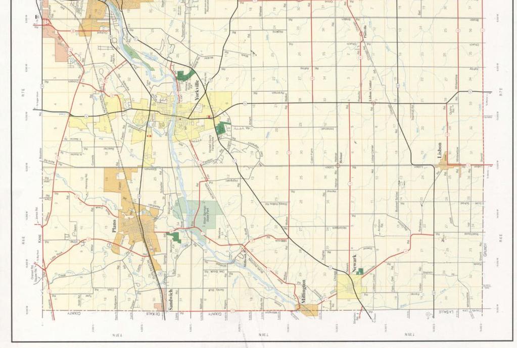
42 33 EXHIBIT 7

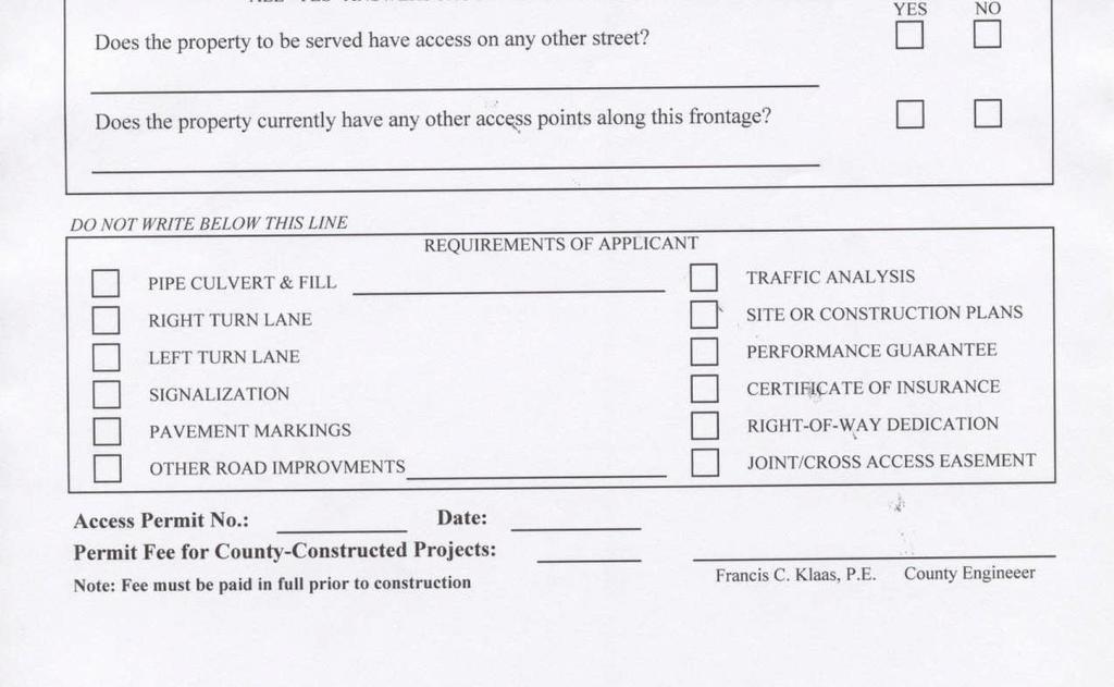
43 34 EXHBIT 8
Access Management Standards
 Access Management Standards This section replaces Access Control Standards on Page number 300-4 of the Engineering Standards passed February 11, 2002 and is an abridged version of the Access Management
CHAPTER 9: VEHICULAR ACCESS CONTROL Introduction and Goals Administration Standards
 9.00 Introduction and Goals 9.01 Administration 9.02 Standards 9.1 9.00 INTRODUCTION AND GOALS City streets serve two purposes that are often in conflict moving traffic and accessing property. The higher
ELMORE COUNTY HIGHWAY DEPARTMENT
 Adopted 11/27/06 Effective 2/1/07 Amended 4/10/08 ELMORE COUNTY HIGHWAY DEPARTMENT 155 County Shop Road Wetumpka, Alabama 36092 Phone (334) 567-1162 Fax (334) 567-1100 Access Management Policy The Elmore
ORDINANCE NO
 ORDINANCE NO. 07-5424 AN ORDINANCE OF THE CITY OF BILLINGS, PROVIDING THAT THE BILLINGS, MONTANA CITY CODE BE AMENDED BY REVISING SECTION 6-1208; PROVIDING CHANGES TO CERTAIN CURB CUT LENGTHS AND REGULATIONS.
M I D - C O A S T REGIONAL PLANNING COMMISSION 166 SOUTH MAIN STREET, SUITE 201 ROCKLAND, ME (207)
") M I D - C O A S T REGIONAL PLANNING COMMISSION 166 SOUTH MAIN STREET, SUITE 201 ROCKLAND, ME 04841 (207) 594-2299 Appropriate access management of municipal roadways can enhance safety, maintain roadway
M I D - C O A S T REGIONAL PLANNING COMMISSION 166 SOUTH MAIN STREET, SUITE 201 ROCKLAND, ME 04841 (207) 594-2299 Appropriate access management of municipal roadways can enhance safety, maintain roadway
800 Access Control, R/W Use Permits and Drive Design
 Table of Contents 801 Access Control... 8-1 801.1 Access Control Directives... 8-1 801.2 Access Control Policies... 8-1 801.2.1 Interstate Limited Access... 8-1 801.2.2 Limited Access... 8-1 801.2.3 Controlled
Town of Vermont Driveway Permit Ordinance
 Town of Vermont Driveway Permit Ordinance 4.00 TITLE AND PURPOSE The title of this ordinance is the Town of Vermont Driveway Permit Ordinance. The purpose is to regulate the establishment, repair, construction,
TRAFFIC MANAGEMENT STANDARDS CITY OF GARLAND TRANSPORTATION DEPARTMENT
 TRAFFIC MANAGEMENT STANDARDS CITY OF GARLAND TRANSPORTATION DEPARTMENT JUNE 1996 TABLE OF CONTENTS 1.0 Street Design Standards 1.1 Right-of-Way Requirements 1.2 Median Openings 1.3 Sidewalks 1.4 Traffic
TITLE 16. TRANSPORTATION CHAPTER 27. TRAFFIC REGULATIONS AND TRAFFIC CONTROL DEVICES
 NOTE: This is a courtesy copy of this rule. The official version can be found in the New Jersey Administrative Code. Should there be any discrepancies between this text and the official version, the official
TOWN OF PRIMROSE DANE COUNTY, WI DRIVEWAY ORDINANCE
 TOWN OF PRIMROSE DANE COUNTY, WI DRIVEWAY ORDINANCE 1.01 PURPOSE The purpose of this Ordinance is to regulate the establishment, construction, improvement, modification, or the reworking of a driveway
DRIVEWAY STANDARDS EXHIBIT A. The following definition shall replace the definition of driveway in Section 62:
 1365 S. Camino del Rio Durango, CO 81303 970-382-6363 DRIVEWAY STANDARDS Resolution 2014-40 EXHIBIT A The following definition shall replace the definition of driveway in Section 62: Driveway means a roadway,
POLICY FOR THE ESTABLISHMENT AND POSTING OF SPEED LIMITS ON COUNTY AND TOWNSHIP HIGHWAYS WITHIN MCHENRY COUNTY, ILLINOIS
 POLICY FOR THE ESTABLISHMENT AND POSTING OF SPEED LIMITS ON COUNTY AND TOWNSHIP HIGHWAYS WITHIN MCHENRY COUNTY, ILLINOIS MCHENRY COUNTY DIVISION OF TRANSPORTATION 16111 NELSON ROAD WOODSTOCK, IL 60098
ARTICLE 8 OFF-STREET PARKING AND PRIVATE DRIVEWAY STANDARDS
 ARTICLE 8 OFF-STREET PARKING AND PRIVATE DRIVEWAY STANDARDS TABLE OF CONTENTS SECTION PAGE 8.1 GENERAL STANDARDS...8-2 8.2 PRIVATE DRIVEWAY PROVISIONS...8-4 8.3 OFF-STREET PARKING STANDARDS...8-5 8.4 OFF-STREET
Purpose: General Provisions:
 10-19-1 Purpose: The purpose of off-street parking requirements is to promote traffic/pedestrian safety and efficiency and to minimize hard surfaced areas to reduce storm water run-off and visual impacts
# TO: FROM: PREPARED BY: DATE: SUBJECT:
 Agenda Item # TO: Metropolitan Planning Commissioners FROM: Jeff Welch, MPC Interim Executive Director PREPARED BY: Dave Hill, MPC Deputy Director DATE: March 12, 2015 SUBJECT: Knox County Zoning Ordinance
CHAPTER 3. Driveways (Rev. 9/04, Ord )
") CHAPTER 3 Driveways (Rev. 9/04, Ord. 2004-6) 6-3-1 Driveway Permit Required 6-3-2 Driveway Location, Design and Construction Requirements 6-3-3 Driveway Aprons Installation/Replacement Improvement Policy
CHAPTER 3 Driveways (Rev. 9/04, Ord. 2004-6) 6-3-1 Driveway Permit Required 6-3-2 Driveway Location, Design and Construction Requirements 6-3-3 Driveway Aprons Installation/Replacement Improvement Policy
DRIVEWAY/APPROACH PERMIT APPLICATION Applicant Type: Architect/Engineer Contractor Owner
 DRIVEWAY/APPROACH PERMIT APPLICATION Applicant Type: Architect/Engineer Contractor Owner Lake Elmo City Hall 651-747-3900 3880 Laverne Avenue North Lake Elmo, MN 55042 Project Address: Property Owner:
Vista Municipal Code
 Section 16.57.050 Private streets prohibited in certain zones. No lots zoned for multi-family, commercial, or industrial uses may be created using private street easements for access, except as provided
PERMIT FOR INSTALLATION ON COUNTY RIGHTS-OF-WAY: ACCESS DRIVEWAYS RESIDENTIAL
 PERMIT FOR INSTALLATION ON COUNTY RIGHTS-OF-WAY: ACCESS DRIVEWAYS RESIDENTIAL Submit To Martin County Judge s Office P.O. Box 1330 Stanton Texas 79782-1330 mhernandez@co.martin.tx.us APPLICATION: Permittee
Driveway Entrance Policy for Residential Properties - District 3 - All Wards
 Driveway Entrance Policy for Residential Properties - District 3 - All Wards (City Council on August 1, 2, 3 and 4, 2000, adopted this Clause, without amendment.) The North York Community Council recommends
ORDINANCE TOWN OF ALBANY. Revised 8/19/03 GREEN COUNTY WISCONSIN
 ORDINANCE 300-01 TOWN OF ALBANY Revised 8/19/03 GREEN COUNTY WISCONSIN DRIVEWAY ORDINANCE 1. AUTHORITY This ordinance is adopted pursuant to the general police powers granted under Sec.60.22 (3) and 61.34
DRAFT ACCESS MANAGEMENT POLICY
 DRAFT ACCESS MANAGEMENT POLICY Minnehaha County Highway Department Transportation Excellence. East 0 th Street North Sioux Falls, SD 0 June 0 The following guidelines are hereby set forth to serve as the
POLICIES FOR THE INSTALLATION OF SPEED HUMPS (Amended May 23, 2011)
") (Amended May 23, 2011) 1. Speed humps are an appropriate mechanism for reducing speeds on certain streets in Pasadena when properly installed under the right circumstances. 2. Speed humps can be considered
(Amended May 23, 2011) 1. Speed humps are an appropriate mechanism for reducing speeds on certain streets in Pasadena when properly installed under the right circumstances. 2. Speed humps can be considered
DRIVEWAY ENTRANCES GENERAL. 1. Description
 GENERAL 1. Description This standard identifies the minimum requirements that shall be met for all driveway entrances in the design and construction of elements for Arlington County Horizontal Design Standards.
EL DORADO COUNTY REGIONAL FIRE PROTECTION STANDARD
 EL DORADO COUNTY REGIONAL FIRE PROTECTION STANDARD EMERGENCY APPARATUS ACCESS WAYS STANDARD #B-003 EFFECTIVE 05-05-2009 PURPOSE To establish a consistent guideline for fire access roadways required by
POLICY AND PROCEDURE FOR SPEED HUMP INSTALLATION. Effective Date: July 10, 2013
 CITY OF MORENO VALLEY DEPARTMENT OF PUBLIC WORKS TRANSPORTATION ENGINEERING DIVISION Administration Policy #A-14A POLICY AND PROCEDURE FOR SPEED HUMP INSTALLATION Effective Date: July 10, 2013 Approved
INDUSTRIAL DEVELOPMENT
 INDUSTRIAL DEVELOPMENT Traffic Impact Study Plainfield, Illinois August 2018 Prepared for: Seefried Industrial Properties, Inc. TABLE OF CONTENTS Executive Summary 2 Introduction 3 Existing Conditions
THE CORPORATION OF THE TOWNSHIP OF MIDDLESEX CENTRE BY-LAW NUMBER
 THE CORPORATION OF THE TOWNSHIP OF MIDDLESEX CENTRE BY-LAW NUMBER 2006-052 BEING A BY-LAW TO REGULATE AND CONTROL PARKING WITHIN THE TOWNSHIP OF MIDDLESEX CENTRE WHEREAS the Municipal Act authorizes local
CROW WING COUNTY HIGHWAY DEPARTMENT APPLICATION FOR PERMIT TO CONSTRUCT DRIVEWAY ACCESS TO ROADS UNDER COUNTY JURISDICTION CONSTRUCTION INFORMATION
 CROW WING COUNTY HIGHWAY DEPARTMENT APPLICATION FOR PERMIT TO CONSTRUCT DRIVEWAY ACCESS TO ROADS UNDER COUNTY JURISDICTION Crow Wing County Highway Department 16589 CR 142 Brainerd, MN 56401 Crow Wing
Plan Check Policies and Guidelines
 Plan Check Policies and Guidelines VII. A. INTRODUCTION Traffic signing and striping plans are required for all General Plan Roads and any roadway that is 56-foot wide curb-to-curb (78 R/W) or wider. Transportation
Date of Issue: For: County Engineer. County Road No.: Maintenance Area: Section Forman Payment Required: (Options: Cash Cheque Credit Card)
") County of Wellington Engineering Services Department Roads Division 74 Woolwich Street Guelph, Ontario N1H 3T9 Phone: (519) 837-2601 Fax: (519) 837-8138 Email: roadsinfo@wellington.ca ENTRANCE PERMIT OWNER/APPLICANT
County of Wellington Engineering Services Department Roads Division 74 Woolwich Street Guelph, Ontario N1H 3T9 Phone: (519) 837-2601 Fax: (519) 837-8138 Email: roadsinfo@wellington.ca ENTRANCE PERMIT OWNER/APPLICANT
CHAPTER 11 SNOWMOBILES AND ALL-TERRAIN VEHICLES SNOWMOBILE AND ALL-TERRAIN VEHICLE REGULATIONS
 241 CHAPTER 11 SNOWMOBILES AND ALL-TERRAIN VEHICLES 11.001 INTENT The City of Cornell, Chippewa County adopts the following Ordinance to regulate the use of snowmobiles and all-terrain vehicles and to
Lake County Building Department
 Lake County Building Department P.O. Box 513 505 Harrison Avenue Leadville, CO 80461 (719) 486-2875 Fax (719) 486-4179 Driveway Permit (Resolutions 98-15 and 98-35) PERMIT: To connect a driveway or parking
Re: Amend Sections and File No ZA Marcus Lotson, Development Services Planner
 Page 1 To: From: The Planning Commission MPC Staff Date: April 5, 2016 Subject: Re: Amend Sections 8-3082 and 8-3090 Marcus Lotson, Development Services Planner Issue: Proposed amendments to the zoning
TRAFFIC IMPACT STUDY. USD #497 Warehouse and Bus Site
 TRAFFIC IMPACT STUDY for USD #497 Warehouse and Bus Site Prepared by: Jason Hoskinson, PE, PTOE BG Project No. 16-12L July 8, 216 145 Wakarusa Drive Lawrence, Kansas 6649 T: 785.749.4474 F: 785.749.734
TRAFFIC CALMING PROGRAM
 TRAFFIC CALMING PROGRAM PROGRAM BASICS Mount Pleasant Transportation Department 100 Ann Edwards Lane Mt. Pleasant, SC 29465 Tel: 843-856-3080 www.tompsc.com The Town of Mount Pleasant has adopted a traffic
Table of Contents INTRODUCTION... 3 PROJECT STUDY AREA Figure 1 Vicinity Map Study Area... 4 EXISTING CONDITIONS... 5 TRAFFIC OPERATIONS...
 Crosshaven Drive Corridor Study City of Vestavia Hills, Alabama Table of Contents INTRODUCTION... 3 PROJECT STUDY AREA... 3 Figure 1 Vicinity Map Study Area... 4 EXISTING CONDITIONS... 5 TRAFFIC OPERATIONS...
MOTOR VEHICLE ORIENTED BUSINESSES.
 ARTICLE 23. MOTOR VEHICLE ORIENTED BUSINESSES. Sec. 25-23.1. Conditional Use. Motor vehicle oriented businesses (MVOB) shall require a Conditional Use Permit in all districts as indicated in Appendix B,
PLEASE SUBMIT THE CORRECT PERMIT FEE WITH PAGES 1 & 3 OF APPLICATION TO: OCONTO COUNTY HIGHWAY DEPT, P.O. BOX 138, OCONTO, WI 54153
 PLEASE SUBMIT THE CORRECT PERMIT FEE WITH PAGES 1 & 3 OF APPLICATION TO: OCONTO COUNTY HIGHWAY DEPT, P.O. BOX 138, OCONTO, WI 54153 APPLICATION/PERMIT TO INSTALL ACCESS DRIVEWAY TO A COUNTY TRUNK HIGHWAY
Community Design Standards
 In accordance with the Zoning Ordinance Update Parking and Loading Standards Adopted December 15, 2015 PARKING AND LOADING Sections: 4.1 Purpose and Intent 4.2 Definitions 4.3 Parking Plan Required 4.4
SAN RAFAEL CITY COUNCIL AGENDA REPORT
 Agenda Item No: 5.a Meeting Date: November 20, 2017 Department: Public Works SAN RAFAEL CITY COUNCIL AGENDA REPORT Prepared by: Bill Guerin, Director of Public Works TOPIC: IMPLEMENTATION OF PARKING TIME
CONTENTS I. INTRODUCTION... 2 II. SPEED HUMP INSTALLATION POLICY... 3 III. SPEED HUMP INSTALLATION PROCEDURE... 7 APPENDIX A... 9 APPENDIX B...
 Speed Hump Program CONTENTS I. INTRODUCTION... 2 II. SPEED HUMP INSTALLATION POLICY... 3 1. GENERAL... 3 2. ELIGIBILITY REQUIREMENTS... 3 A. PETITION... 3 B. OPERATIONAL AND GEOMETRIC CHARACTERISTICS OF
Department of Planning and Land Services Development Engineering GATES PERMITTING, DESIGN & INSPECTION GUIDE
 Pierce County Department of Planning and Land Services Development Engineering GATES PERMITTING, DESIGN & INSPECTION GUIDE Effective Date: 12/2/2002 Revision Date: 02/19/2010 Introduction The purpose of
COUNTY ROAD SPEED LIMITS. Policy 817 i
 Table of Contents COUNTY ROAD SPEED LIMITS Policy 817.1 PURPOSE... 2.2 APPLICABILITY... 2.3 DEFINITIONS... 2.4 STATE ENABLING LEGISLATION... 3.5 SPEED LIMITS ON COUNTY ROADS (CCC 11.04)... 3.6 ESTABLISHING
Plan Check Policies and Guidelines
 VIII. TRAFFIC SIGNING AND STRIPING PLANS A. INTRODUCTION Traffic signing and striping plans are required for all General Plan Roads and any roadway that is 56-foot wide curb-to-curb (78 R/W) or wider.
CITY of ALBUQUERQUE TWENTY-FIRST COUNCIL
 CITY of ALBUQUERQUE TWENTY-FIRST COUNCIL COUNCIL BILL NO. O-- ENACTMENT NO. SPONSORED BY: Isaac Benton [Bracketed/Underscored Material] - New 0 0 ORDINANCE AMENDING THE ZONING CODE TO PERMIT MOBILE FOOD
/ Planning and Zoning Staff Report Lonestar Land, LLC. - Rezone, RZ
 / Planning and Zoning Staff Report Lonestar Land, LLC. - Rezone, RZ2018-0019 Hearing Date: October 18, 2018 Development Services Department Applicant: Lonestar Land, LLC. Representative: Lance Warnick
CHAPTER 1-7 ARTICLE V AN ORDINANCE PERMITTING AND REGULATING THE OPERATION OF GOLF CARTS ON PUBLIC STREETS
 CHAPTER 1-7 ARTICLE V AN ORDINANCE PERMITTING AND REGULATING THE OPERATION OF GOLF CARTS ON PUBLIC STREETS WHEREAS, there is public interest in having a means of local travel that is cost effective and
Subchapter 20 Transportation
 Subchapter 20 Transportation Sections: 35.20.1 Purpose. 35.20.2 Street Standards. 35.20.3 Pedestrian / Bicycle Facility Standards. 35.20.4 Driveway Standards. 35.20.5 Public Transit Standards. 35.20.1
CITY OF PORTSMOUTH DEPARTMENT OF PUBLIC WORKS (DPW) DRIVEWAY RULES AND PROCEDURES
 DRIVEWAY RULES AND PROCEDURES") CITY OF PORTSMOUTH DEPARTMENT OF PUBLIC WORKS (DPW) DRIVEWAY RULES AND PROCEDURES The purpose of a driveway permit is to secure access from a private property to the public right-of-way. It is required
CITY OF PORTSMOUTH DEPARTMENT OF PUBLIC WORKS (DPW) DRIVEWAY RULES AND PROCEDURES The purpose of a driveway permit is to secure access from a private property to the public right-of-way. It is required
Fire Apparatus Access Roads in Marysville
 Fire Apparatus Access Roads in Marysville 1094 Cedar Avenue, Marysville, Washington 98270 Phone (360) 363-8500 Fax (360) 659-1382 These documents all address various requirements for Fire Apparatus Access
TRAFFIC DEPARTMENT 404 EAST WASHINGTON BROWNSVILLE, TEXAS City of Brownsville Speed Hump Installation Policy
 A. GENERAL Speed humps are an effective and appropriate device for safely reducing vehicle speeds on certain types of streets when installed accordance with the provisions of this policy. In order for
AMENDED CULVERT POLICY WITH MAIL BOX POLICY
 AMENDED CULVERT POLICY WITH MAIL BOX POLICY REVISED MARCH 28, 2017 COMMISSIONERS COURT ORDER NO. 17-03-168 POLICY ACCEPTANCE AGREEMENT This page is to be signed by the Requesting Party and returned in
SPEED HUMP POLICY and PROCEDURES for RESIDENTIAL AREAS
 SPEED HUMP POLICY and PROCEDURES for RESIDENTIAL AREAS City of Panama City, Florida Public Works Department 9 Harrison Avenue Panama City, Florida 32401 Phone: (850) 872-3015 Effective 1/22/08 Table of
ORDINANCE NO NOW, THEREFORE, be it ordained by the City Council ofthe City of Gulf Breeze, Florida, as follows:
 ORDINANCE NO. 05-13 AN ORDINANCE OF THE CITY OF GULF BREEZE ADOPTING SECTION 18-78 OF THE CODE OF ORDINANCES OF THE CITY OF GULF BREEZE PROVIDING FOR REGULATION OF PARKING IN RESIDENTIAL DISTRICTS; ESTABLISHING
Plumas County Record of Surveys
 Plumas County Record of Surveys Guidelines & Submittal Requirements 1 Office of the County Engineer Guide to processing a Record of Survey When Required 1) When a material evidence or physical change,
KENT COUNTY ROAD COMMISSION
 KENT COUNTY ROAD COMMISSION Rules to regulate driveways, banners and parades upon and over public highways under the jurisdiction of the Board of County Road Commissioners of the County of Kent. Promulgated
ARTICLE 15 PARKING AND LOADING REQUIREMENTS
 ARTICLE 15 PARKING AND LOADING REQUIREMENTS SECTION 15.01 OFF-STREET PARKING REQUIREMENT There shall be provided in all districts at the time of erection or enlargement of any main building or structure,
NAU DESIGN GUIDELINES FOR DISABLED ACCESS PARKING AND ACCESSIBLE ROUTE AT VEHICULAR TRAFFIC AREAS
 NAU DESIGN GUIDELINES FOR DISABLED ACCESS PARKING AND ACCESSIBLE ROUTE AT Intent, Purpose And Goals: The intent and purpose of these NAU technical requirements is to establish minimum requirements to safeguard
City of Lafayette Staff Report Circulation Commission
 City of Lafayette Staff Report Circulation Commission Meeting Date: September 5, 2016 Staff: Subject: James Hinkamp, Transportation Planner Consideration of a No Parking Zone on Victoria Avenue Summary
Traffic Impact Study Speedway Gas Station Redevelopment
 Traffic Impact Study Speedway Gas Station Redevelopment Warrenville, Illinois Prepared For: Prepared By: April 11, 2018 Table of Contents 1. Introduction... 1 2. Existing Conditions... 4 Site Location...
City of San Juan Capistrano Agenda Report
 City of San Juan Capistrano Agenda Report 10/17/2017 ES TO: FROM: Honorable Mayor and Members of the City Council ~n Siegel, City Manager SUBMITTED BY: DATE: SUBJECT: Maria Morris, City Clerk W\M October
Engineering Report: Shasta-Trinity National Forest. South Fork Management Unit. Analysis of. National Forest System Road 30N44
 Engineering Report: Shasta-Trinity National Forest South Fork Management Unit Analysis of National Forest System Road 30N44 (milepost 0.00 to 0.40) for Motorized Mixed Use Designation Forest: Shasta-Trinity
CHAPTER 140 DRIVEWAYS
 CHAPTER 140 DRIVEWAYS 140.01 Purpose 140.10 Driveway Location 140.02 Definitions 140.11 Driveway Maintenance 140.03 Driveway Construction 140.12 Failure To Maintain 140.04 Driveway Surfaces 140.13 Permit
CEDAR COUNTY ACCESS POLICY FOR SUBDIVISION, DRIVEWAY, AND FIELD ACCESS
 CEDAR COUNTY ACCESS POLICY FOR SUBDIVISION, DRIVEWAY, AND FIELD ACCESS The purpose of this policy is to establish Cedar County's rules for control of access to secondary highways throughout the county.
HIGHLANDS COUNTY BOARD OF COUNTY COMMISSIONERS ENGINEERING DEPARTMENT RESIDENTIAL DRIVEWAY SPECIFICATIONS
 HIGHLANDS COUNTY BOARD OF COUNTY COMMISSIONERS ENGINEERING DEPARTMENT RESIDENTIAL DRIVEWAY SPECIFICATIONS THERE MAY ONLY BE ONE DRIVEWAY PER BUILDING PARCEL. CORNER LOTS MUST CONSTRUCT THE ONE DRIVEWAY
AVE MARIA STEWARDSHIP COMMUNITY DISTRICT
 AVE MARIA STEWARDSHIP COMMUNITY DISTRICT GOLF CART USE AGREEMENT To receive a registration decal, please complete the AMSCD Golf Cart Use Agreement and return the form to: AVE MARIA STEWARDSHIP COMMUNITY
SPEED CUSHION POLICY AND INSTALLATION PROCEDURES FOR RESIDENTIAL STREETS
 SPEED CUSHION POLICY AND INSTALLATION PROCEDURES FOR RESIDENTIAL STREETS CITY OF GRAND PRAIRIE TRANSPORTATION SERVICES DEPARTMENT SPEED CUSHION INSTALLATION POLICY A. GENERAL Speed cushions are an effective
APPLICATION FOR PERMIT to construct, operate, maintain, use and/or remove within a county road right-of-way
 IONIA COUNTY ROAD COMMISSION 170 E. Riverside Drive; P.O. Box 76, Ionia MI 48846 (616) 527-1700 (office) or (616) 527-8848 (fax) APPLICATION FOR PERMIT to construct, operate, maintain, use and/or remove
Amended DRIVEWAY ORDINANCE TOWN OF CLIFTON
 Amended 2007-02 DRIVEWAY ORDINANCE TOWN OF CLIFTON SECTION 1. Purpose The purpose of this ordinance is to regulate the location, design and construction of driveways within the Town of Clifton, Pierce
CITY OF FARMERSVILLE, TEXAS
 CITY OF FARMERSVILLE, TEXAS THOROUGHFARE STANDARDS DESIGN MANUAL Adopted September 12, 2006 By Ordinance #2006-46 Amended June 12, 2007 By Ordinance #2007-23 TABLE OF CONTENTS I. General Requirements.....1
Applicable California Vehicle Code Sections, 2015 Edition
 Applicable California Vehicle Code Sections, 2015 Edition Speed limits in California are governed by the California Vehicle Code (CVC), Sections 22348 through 22413; also, pertinent sections are found
Ramsey, Minnesota, Code of Ordinances >> PART II - CODE OF ORDINANCES >> Chapter 54 - TRAFFIC AND VEHICLES >> ARTICLE IV. - RECREATIONAL VEHICLES >>
 Ramsey, Minnesota, Code of Ordinances >> PART II - CODE OF ORDINANCES >> Chapter 54 - TRAFFIC AND VEHICLES >> ARTICLE IV. - RECREATIONAL VEHICLES >> ARTICLE IV. - RECREATIONAL VEHICLES [36] Sec. 54-96.
ANN ARBOR CITY NOTICE ORDINANCE NO. ORD OFF STREET PARKING CHAPTER 59
 ANN ARBOR CITY NOTICE ORDINANCE NO. ORD-12-04 OFF STREET PARKING CHAPTER 59 AN ORDINANCE TO AMEND SECTIONS 5:168 AND 5:169 OF CHAPTER 59 (OFF- STREET PARKING) OF TITLE V OF THE CODE OF THE CITY OF ANN
Traffic Engineering Study
 Traffic Engineering Study Bellaire Boulevard Prepared For: International Management District Technical Services, Inc. Texas Registered Engineering Firm F-3580 November 2009 Executive Summary has been requested
Parking Management Element
 Parking Management Element The State Transportation Planning Rule, adopted in 1991, requires that the Metropolitan Planning Organization (MPO) area implement, through its member jurisdictions, a parking
Knox County Zoning Ordinance Amendments: Section Off-street parking lot layout, construction and maintenance. 4-A-15-OA
 Agenda Item # 6 TO: FROM: Metropolitan Planning Commissioners Jeff Welch, MPC Interim Executive Director PREPARED BY: Dave Hill, MPC Deputy Director DATE: April 9, 2015 SUBJECT: Knox County Zoning Ordinance
OSCODA COUNTY ORV ORDINANCE NO
 OSCODA COUNTY ORV ORDINANCE NO. 2009-001 AN ORDINANCE PURSUANT TO ACT 240 OF THE PUBLIC ACTS OF 2008 AUTHORIZING AND REGULATING THE OPERATION OF OFF-ROAD VEHICLES ON ROADS WITHIN OSCODA COUNTY, PROVIDING
MIDWAY CITY Municipal Code
 TITLE 8 STREETS AND SIDEWALKS MIDWAY CITY Municipal Code CHAPTER 8.01 UTAH CRIMINAL AND TRAFFIC CODE ADOPTED CHAPTER 8.02 UNLAWFUL PARKING CHAPTER 8.03 TRAFFIC REGULATIONS CHAPTER 8.04 RIGHT-OF-WAY REGULATIONS
ERIC S. CASHER, CITY ATTORNEY WINSTON RHODES, AICP, PLANNING MANAGER
 CITY COUNCIL REPORT 8A DATE: AUGUST 15, 2017 TO: MAYOR AND COUNCIL MEMBERS THROUGH: MICHELLE FITZER, CITY MANAGER FROM: ERIC S. CASHER, CITY ATTORNEY WINSTON RHODES, AICP, PLANNING MANAGER SUBJECT: INTRODUCTION
Dixie Transportation Planning Office
 A project must be given a yes rating on items 1 & 2 in order to be prioritized. Sponsor: St. George City Project: Pioneer Parkway Type: Road Widening and Reconstruction Rev. 9/17/2010 Dixie Transportation
STAFF REPORT # CHANGE OF ZONING
 STAFF REPORT #17-2000-0007 CHANGE OF ZONING PLANNING COMMISSION MEETING DATE: November 16, 2017 (Applicant Provided Materials / Traffic Study = Blue) 1. APPLICATION: A public hearing for an application
COUNTY ROAD SPEED LIMITS. Policy 817 i
 Table of Contents COUNTY ROAD SPEED LIMITS Policy 817.1 PURPOSE... 1.2 APPLICABILITY... 1.3 DEFINITIONS... 1.4 STATE ENABLING LEGISLATION... 2.5 SPEED LIMITS ON COUNTY ROADS (CCC 11.04)... 2.6 ESTABLISHING
AASHTO Policy on Geometric Design of Highways and Streets
 AASHTO Policy on Geometric Design of Highways and Streets 2001 Highlights and Major Changes Since the 1994 Edition Jim Mills, P.E. Roadway Design Office 605 Suwannee Street MS-32 Tallahassee, FL 32399-0450
CITY OF DANA POINT AGENDA REPORT BRAD FOWLER, DIRECTOR OF PUBLIC WORKS AND ENGINEERING SERVICES TRAFFIC IMPROVEMENT SUBCOMMITTEE
 03/03/15 Page 1 Item #: 18 CITY OF DANA POINT AGENDA REPORT Reviewed By: DH X CM X CA X DATE: MARCH 3, 2015 TO: FROM SUBJECT: CITY MANAGER/CITY COUNCIL BRAD FOWLER, DIRECTOR OF PUBLIC WORKS AND ENGINEERING
3. Application Fees, Certificate Of Insurance & Performance Bond
 SUBSECTION 13.10 CONSTRUCTION OF DRIVEWAYS 13.10A PERMIT REQUIREMENTS 1. General A driveway or access road serving private property and intersecting with a town road shall be constructed in such a manner
MICHIGAN DEPARTMENT OF TRANSPORTATION SPECIAL PROVISION FOR PAVEMENT RIDE QUALITY (MEAN ROUGHNESS INDEX ACCEPTANCE CRITERIA)
") MICHIGAN DEPARTMENT OF TRANSPORTATION SPECIAL PROVISION FOR PAVEMENT RIDE QUALITY (MEAN ROUGHNESS INDEX ACCEPTANCE CRITERIA) CFS:TEH 1 of 10 APPR:KPK:JFS:07-07-16 FHWA:APPR:07-15-16 a. Description. This
MICHIGAN DEPARTMENT OF TRANSPORTATION SPECIAL PROVISION FOR PAVEMENT RIDE QUALITY (MEAN ROUGHNESS INDEX ACCEPTANCE CRITERIA) CFS:TEH 1 of 10 APPR:KPK:JFS:07-07-16 FHWA:APPR:07-15-16 a. Description. This
City of San Juan Capistrano Agenda Repo_rt
 10/3/2017 City of San Juan Capistrano Agenda Repo_rt 01 TO: Honorable Mayor and Members of the City Council FROM: ~n Siegel, City Manager SUBMITTED BY: Joel Rojas, Development Services Direct~ PREPARED
TRAFFIC CONTROL REGULATIONS
 TRAFFIC CONTROL REGULATIONS Town of Southampton Applies to: Vehicles and Traffic in the Town of Southampton Select Board Original Adoption: November 2, 2017 Amended on: -- Last Reviewed by Select Board:
Town of Goshen Driveway Regulations
 Driveway Regulations 1. Authority These regulations are adopted by the Goshen Planning Board under the authority of New Hampshire RSA 236:13 236:14. They govern the construction and alteration of driveways,
the importance of its role in local economic business operations that these business operations pursuant
 WHEREAS, City development; recognizes COUNCIL CHAMBER 27, 2018 importance its role in local economic WHEREAS, it is in interest City relocations economic vitality employment opportunities Dallas residents;
ANDERSON PROPERTY SITE ANALYSIS
 ANDERSON PROPERTY SITE ANALYSIS Introduction The Montgomery County Department of Transportation (MCDOT) initiated a feasibility study in the fall of 2012 to evaluate the need for transit service expansion
NOW, THEREFORE, BE IT ENACTED BY THE CITY COUNCIL OF THE CITY OF OVIEDO, FLORIDA, AS FOLLOWS:
 ORDINANCE NO. 1659 AN ORDINANCE OF THE CITY OF OVIEDO, FLORIDA PERTAINING TO THE USE OF GOLF CARTS UPON DESIGNATED ROADS WITHIN THE CITY OF OVIEDO SUBJECT TO SPECIFIED RESTRICTIONS AND THE PROVISIONS OF
ORDINANCE NUMBER 3424
 ORDINANCE NUMBER 3424 AN ORDINANCE OF THE MISSOULA CITY COUNCIL AMENDING TITLE 12 STREETS, SIDEWALKS AND PUBLIC PLACES TO ADD CHAPTER 12.22 ENTITLED "PARKING FACILITIES," SECTIONS 12.22.010 THROUGH 12.22.130
2. ELIGIBILITY REQUIREMENTS
 Speed Hump Policy 1. GENERAL The purpose of this policy is to provide guidelines for the application of speed humps. A "speed hump" is a gradual rise and fall of pavement surface across the width of the
TOWN OF BRIDGTON TRAFFIC ORDINANCE
 TOWN OF BRIDGTON TRAFFIC ORDINANCE AN ORDINANCE REGULATING TRAFFIC UPON THE PUBLIC STREETS OF THE TOWN OF BRIDGTON AND REPEALING ALL OTHER ORDINANCES AND SECTIONS OF ORDINANCES IN CONFLICT HEREWITH. Be
GRASS LAKE CHARTER TOWNSHIP PAGE 1 POLICE POWER ORDINANCE
 GRASS LAKE CHARTER TOWNSHIP PAGE 1 JUNK VEHICLE ORDINANCE: PPO-05 Length: 5 Pages Reviewed Revised *10/05 11/18 *denotes date of origin Purpose of Ordinance: An ordinance to secure the public peace, health,
CHAPTER 2 ZONING AND DEVELOPMENT
 2.200 GENERAL DEVELOPMENT STANDARDS CHAPTER 2 ZONING AND DEVELOPMENT Section 2.201 GENERAL PROVISIONS... 2.2-1 Section 2.202 FENCES AND VISIONS CLEARANCE... 2.2-2 2.202.01 Fences... 2.2-2 2.202.02 Vision
EMERGENCY ACCESS POLICY
 Cowlitz 2 Fire & Rescue Policies and Operating Guidelines Policy: EMERGENCY ACCESS POLICY Number Effective Date Approved and Issued: 4001 8/28/02 8/28/02 1.0 REFERENCE 23 CFR Part 650 Subpart C Code of
The Design-Builder shall meet local road criteria provided by the local governing agencies.
 11 ROADWAYS 11.1 General The -Builder shall conduct all Work necessary to meet the requirements of roadways. Roadway classifications include mainline, acceleration lanes, deceleration lanes, auxiliary