Capacity and Level of Service for Highway Segments (I)
|
|
|
- Muriel Alexandrina Davis
- 6 years ago
- Views:
Transcription
1 Capacity and Level of Service for Highway Segments (I) 1
2 Learn how to use the HCM procedures to determine the level of service (LOS) Become familiar with highway design capacity terminology Apply the equations and procedures for estimating speed and density to determine LOS 2

3 Highway Capacity Manual 2010 The Bible of traffic engineers Planning Evaluation Design 3
4 9.1 Freeways A freeway is a divided highway with full Access Control and two or more lanes in each direction Signalized or stop-controlled, at-grade intersections and direct access to adjacent land use are not permitted Freeway is not just fast but full access control Opposing Traffic is separated by a raised barrier, an at-grade median, or a raised traffic island The capacity of a freeway is the maximum sustainable hourly flow rate in one direction, based on the peak 15-minute rate of flow, expressed in passenger cars per hour Basic segment Influence area (reduced capacity) The points at which a basic freeway segment begins and ends depends on the current LOS 4
5

6 capacity 6

7 Freeways Influence areas (capacity reduction) 7
8 Highway Capacity Terminology and Definitions Base Conditions: Criteria that must be satisfied for a basic freeway segment to operate at its maximum capacity (i.e.: good visibility, no heavy vehicles) Free-Flow Speed: A constant value beginning at the y- intercept of each curve and extending to the breakpoint, where the mean speed diminishes Flow Rates Beyond the Breakpoint: For demand volumes beyond the breakpoint, flow rate declines in value until it reaches the capacity of the segment Computing Free-Flow Speed: Can be determined either by field measurements or by formula estimation 8
9 Highway Capacity Terminology and Definitions Base Conditions: Criteria that must be satisfied for a basic freeway segment to operate at its maximum capacity (i.e.: good visibility, no heavy vehicles) Free-Flow Speed: A constant value beginning at the y- intercept of each curve and extending to the breakpoint, where the mean speed diminishes Flow Rates Beyond the Breakpoint: For demand volumes beyond the breakpoint, flow rate declines in value until it reaches the capacity of the segment Computing Free-Flow Speed: Can be determined either by field measurements or by formula estimation 9

10 Highway Capacity Terminology and Definitions Free-Flow Speed: A constant value beginning at the y-intercept of each curve and extending to the breakpoint, where the mean speed diminishes It is typically considered the speed limit When traffic is low on the freeway, speed limit is the only restriction When traffic is high, you begin to feel the interactions with other vehicles 10
11 11


12 Pipe s model H. Rakha et al. A Comparison of the Greenshields, Pipes, and Van Aerde Car-Following and Traffic Stream Models 12
13 Highway Capacity Terminology and Definitions Base Conditions: Criteria that must be satisfied for a basic freeway segment to operate at its maximum capacity (i.e.: good visibility, no heavy vehicles) Free-Flow Speed: A constant value beginning at the y- intercept of each curve and extending to the breakpoint, where the mean speed diminishes Flow Rates Beyond the Breakpoint: For demand volumes beyond the breakpoint, flow rate declines in value until it reaches the capacity of the segment Computing Free-Flow Speed: Can be determined either by field measurements or by formula estimation 13
14 Flow Rates Beyond Break Point Equation 2015 Cengage Learnng Engineering. All Rights Reserved. 14
15 Highway Capacity Terminology and Definitions Base Conditions: Criteria that must be satisfied for a basic freeway segment to operate at its maximum capacity (i.e.: good visibility, no heavy vehicles) Free-Flow Speed: A constant value beginning at the y- intercept of each curve and extending to the breakpoint, where the mean speed diminishes Flow Rates Beyond the Breakpoint: For demand volumes beyond the breakpoint, flow rate declines in value until it reaches the capacity of the segment Computing Free-Flow Speed: Can be determined either by field measurements or by formula estimation 15
16 Free Flow Speed Computation Equation History data + regression analysis (curve fitting) 16
17 Free Flow Speed Computation Equation From Highway Capacity Manual,
18 Level of Service for Freeway Segments LOS is a qualitative measure that describes the operating conditions within a given freeway segment using density (pc/mi) as the quantitative variable and an alphabetic grading system, ranging from A to F Conveys how the density values are perceived by drivers and passengers when traveling in the traffic stream at various demand flow rates (pc/h/ln) k = q p u q p = flow rate u= Average passenger car speed mi/h (km/h) k= Density (pc/mi/ln or pc/km/ln) Note: we use different types of LOS on different types of roads (e.g., freeway vs. arterials 18

19 Density Ranges for each LOS 19

20 LOS A Levels of Service Free-flow operation LOS B Reasonably free flow Ability to maneuver is only slightly restricted Effects of minor incidents still easily absorbed


21 From Highway Capacity Manual, 2000 LOS C Levels of Service Speeds at or near FFS Freedom to maneuver is noticeably restricted Queues may form behind any significant blockage. LOS D Speeds decline slightly with increasing flows Density increases more quickly Freedom to maneuver is more noticeably limited Minor incidents create queuing


22 From Highway Capacity Manual, 2000 Levels of Service LOS E Operation near or at capacity No usable gaps in the traffic stream Operations extremely volatile Any disruption causes queuing LOS F Breakdown in flow Queues form behind breakdown points Demand > capacity
23 23
24 Freeway Capacity Estimation Most of equations are empirical and based on regression analysis Not all have the sound math proofs We can NEVER 100% understand driver behaviors as long as human beings are involved We do not have the luxury of extensively collecting data everywhere Simple traffic models will not reflect many factors, such as truck ratio, even though they are well calibrated (e.g., 1000 cars vs trucks) Equations must be empirically fine tuned to address these issues 24
25 Definitions Passenger car equivalents (PCE) Trucks and RVs behave differently Baseline is a freeway with all passenger cars Traffic is expressed in passenger cars per lane per hour (pc/ln/hr or pcplph) Driver population Non-commuters suck more at driving They may affect capacity Capacity Corresponds to LOS E and v/c = 1.0
26 Calculating the Flow Rate for a Basic Freeway Section q q p = PHF N f p f HV ) q q 26
27 Terrain Segments General terrain refers to a series of single grades that aren t too steep or too long Freeway segments are considered to be on level terrain if the combination of grades and horizontal alignment permits heavy vehicles to maintain the same speed as passenger cars. Grades are generally short and not greater than 2% If the grades and horizontal alignment causes heavy vehicles to reduce to values substantially below those of passenger cars but not to crawl speed*, the segment is considered to be on rolling terrain If heavy vehicles operate at crawl speed then the segments are in mountainous terrain *Crawl Speed: Maximum sustained speed that trucks can maintain on an extended upgrade of a given percent 27

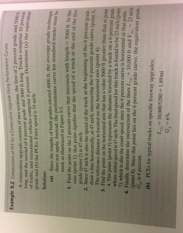
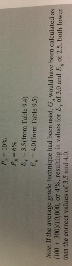
28 Computation of PCE Example (Composite grade) Tables 9.4 and 9.5 are given in the next slide 28 Only suitable for less than 4% grade of all subsections and the total length is shorter than 4,000 feet
29 29
30 When any subsection s grade is more than 4% or total length is shorter than 4,000 feet We calculate the truck/bus speed when they exit the road segment Assume the truck/bus travel at the same grade Using the figure below to estimate the equivalent grade Initial speed Final speed Total Travel distance These are the empirical curves to describe truck/bus s speed changes at different grade The underlying theory is still vehicle kinematics waves but fine tuned with real-world data Because speed changes too much from subsection to the next 30
31 31
Chapter 6. CEE 320 Anne Goodchild. Spring 2008 CEE 320
 Chapter 6 Freeway Level of Service Anne Goodchild Definitions Level of Service (LOS) Chief measure of quality of service Describes operational conditions within a traffic stream. Does not include safety
JCE 4600 Basic Freeway Segments
 JCE 4600 Basic Freeway Segments HCM Applications What is a Freeway? divided highway with full control of access two or more lanes for the exclusive use of traffic in each direction no signalized or stop-controlled
Lecture 4: Capacity and Level of Service (LoS) of Freeways Basic Segments. Prof. Responsável: Filipe Moura
 of Freeways Basic Segments. Prof. Responsável: Filipe Moura") Lecture 4: Capacity and Level of Service (LoS) of Freeways Basic Segments Prof. Responsável: Filipe Moura Engenharia de Tráfego Rodoviário Lecture 4 - Basic Freeway segments 1 CAPACITY AND LEVEL OF SERVICE
Lecture 4: Capacity and Level of Service (LoS) of Freeways Basic Segments Prof. Responsável: Filipe Moura Engenharia de Tráfego Rodoviário Lecture 4 - Basic Freeway segments 1 CAPACITY AND LEVEL OF SERVICE
MULTILANE HIGHWAYS. Highway Capacity Manual 2000 CHAPTER 21 CONTENTS
 CHAPTER 2 MULTILANE HIGHWAYS CONTENTS I. INTRODUCTION...2- Base Conditions for Multilane Highways...2- Limitations of the Methodology...2- II. METHODOLOGY...2- LOS...2-2 Determining FFS...2-3 Estimating
Multilane Highways. Lecture Notes in Transportation Systems Engineering. Prof. Tom V. Mathew. 1 Introduction 1
 Multilane Highways Lecture Notes in Transportation Systems Engineering Prof. Tom V. Mathew Contents 1 Introduction 1 2 Multilane Highways 2 2.1 Highway Classification............................... 2 2.2
FE Review-Transportation-II. D e p a r t m e n t o f C i v i l E n g i n e e r i n g U n i v e r s i t y O f M e m p h i s
 FE Review-Transportation-II D e p a r t m e n t o f C i v i l E n g i n e e r i n g U n i v e r s i t y O f M e m p h i s Learning Objectives Design, compute, and solve FE problems on Freeway level of
MEMORANDUM. Figure 1. Roundabout Interchange under Alternative D
 MEMORANDUM Date: To: Liz Diamond, Dokken Engineering From: Subject: Dave Stanek, Fehr & Peers Western Placerville Interchanges 2045 Analysis RS08-2639 Fehr & Peers has completed a transportation analysis
Two Lane Highways Procedures from 2000 Highway Capacity Manual
 Two Lane Highways Procedures from 2000 Highway Capacity Manual Two lane-1 Maximum flow rates on two-way streets: 1700 cars/hour in one direction and 3200 in both directions Level of Service is based on:
P07033 US 50 EB Weaving Analysis between El Dorado Hills and Silva Valley Ramp Metering Analysis for US 50 EB On-Ramp at Latrobe Road
 180 Grand Avenue, Suite 250 428 J Street, Suite 500 Oakland, CA 94612 Sacramento, CA 95814 510.839.1742 916.266.2190 510.839.0871 fax 916.266.2195 Dowling Associates, Inc. www.dowlinginc.com traffic@dowlinginc.com
To: File From: Adrian Soo, P. Eng. Markham, ON File: Date: August 18, 2015
 Memo To: From: Adrian Soo, P. Eng. Markham, ON : 165620021 Date: Reference: E.C. Row Expressway, Dominion Boulevard Interchange, Dougall Avenue Interchange, and Howard 1. Review of Interchange Geometry
Evaluation Considerations and Geometric Nuances of Reduced Conflict U-Turn Intersections (RCUTs)
") Evaluation Considerations and Geometric Nuances of Reduced Conflict U-Turn Intersections (RCUTs) 26 th Annual Transportation Research Conference Saint Paul RiverCentre May 20, 2015 Presentation Outline
Evaluation Considerations and Geometric Nuances of Reduced Conflict U-Turn Intersections (RCUTs) 26 th Annual Transportation Research Conference Saint Paul RiverCentre May 20, 2015 Presentation Outline
The Highway Safety Manual: Will you use your new safety powers for good or evil? April 4, 2011
 The Highway Safety Manual: Will you use your new safety powers for good or evil? April 4, 2011 Introductions Russell Brownlee, M.A. Sc., FITE, P. Eng. Specialize in road user and rail safety Transportation
Effect of Police Control on U-turn Saturation Flow at Different Median Widths
 Effect of Police Control on U-turn Saturation Flow at Different Widths Thakonlaphat JENJIWATTANAKUL 1 and Kazushi SANO 2 1 Graduate Student, Dept. of Civil and Environmental Eng., Nagaoka University of
Oakbrook Village Plaza City of Laguna Hills
 Oakbrook Village Plaza City of Laguna Hills Traffic Impact Analysis Prepared by: HDR Engineering 3230 El Camino Real, Suite 200 Irvine, CA 92602 October 2012 Revision 3 D-1 Oakbrook Village Plaza Laguna
Sight Distance. A fundamental principle of good design is that
 Session 9 Jack Broz, PE, HR Green May 5-7, 2010 Sight Distance A fundamental principle of good design is that the alignment and cross section should provide adequate sight lines for drivers operating their
COMPARISON OF FREE FLOW SPEED ESTIMATION MODELS
 COMPARISON OF FREE FLOW SPEED ESTIMATION MODELS Usman Tasiu Abdurrahman 1, Othman Che Puan 2* Muttaka Na iya Ibrahim 3 1,2,3 Faculty of Civil Engineering, Universiti Teknologi Malaysia, 81310 Skudai, Johor,
Tongaat Hullette Developments - Cornubia Phase 2. Technical Note 02 - N2/M41 AIMSUN Micro-simulation Analysis
 Technical Note 02 - N2/M41 AIMSUN Micro-simulation Tongaat Hullette Developments Cornubia Phase 2 Technical Note 02 - N2/M41 AIMSUN Micro-simulation Analysis Prepared by: 18/11/14 Justin Janki Date Approvals
CDOT SPF Development and 10 Years of Application. A Practical Approach...
 CDOT SPF Development and 10 Years of Application A Practical Approach...... Jake Kononov, P.E. Ph.D. Bryan K. Allery, P.E. National SPF Summit Chicago 2009 In Order to Manage Safety Effectively, We Need
APPENDIX B Traffic Analysis
 APPENDIX B Traffic Analysis Rim of the World Unified School District Reconfiguration Prepared for: Rim of the World School District 27315 North Bay Road, Blue Jay, CA 92317 Prepared by: 400 Oceangate,
Interstate 85 Widening Phase III Interchange Modification Report Exit 98 Frontage Road Off-Ramp. Cherokee County, SC
 Interstate 85 Widening Phase III Interchange Modification Report Exit 98 Frontage Road Off-Ramp Cherokee County, SC Prepared for: South Carolina Department of Transportation Prepared by: Stantec Consulting
Level of Service Classification for Urban Heterogeneous Traffic: A Case Study of Kanapur Metropolis
 Level of Service Classification for Urban Heterogeneous Traffic: A Case Study of Kanapur Metropolis B.R. MARWAH Professor, Department of Civil Engineering, I.I.T. Kanpur BHUVANESH SINGH Professional Research
Traffic Engineering Study
 Traffic Engineering Study Bellaire Boulevard Prepared For: International Management District Technical Services, Inc. Texas Registered Engineering Firm F-3580 November 2009 Executive Summary has been requested
American Association of State Highway and Transportation Officials. June Dear Customer:
 American Association of State Highway and Transportation Officials John R. Njord, President Executive Director Utah Department of Transportation John Horsley Executive Director June 2004 Dear Customer:
ZINFANDEL LANE / SILVERADO TRAIL INTERSECTION TRAFFIC ANALYSIS
 ZINFANDEL LANE / SILVERADO TRAIL INTERSECTION TRAFFIC ANALYSIS UPDATED TRAFFIC STUDY FOR THE PROPOSED RAYMOND VINEYARDS WINERY USE PERMIT MODIFICATION #P11-00156 AUGUST 5, 2014 PREPARED BY: OMNI-MEANS,
Freeway Weaving and Ramp Junction Analysis
 TEXAS TECH UNIVERSITY Freeway Weaving and Ramp Junction Analysis Along IH 27 at Plainview, TX Hao Xu, Jared A. Squyres, Wesley Kumfer, and Hongchao Liu 7/15/2011 Table of Contents Project Description...
Transport Modes and Technologies A Walking Tour on Capacity, LOS. Urban Transportation Planning MIT Course 1.252j/11.
 Transport Modes and Technologies A Walking Tour on Capacity, LOS Urban Transportation Planning MIT Course 1.252j/11.380j Fall 2006 Mikel Murga, MIT Research Associate Transport Modes and Technologies Private
Date: February 7, 2017 John Doyle, Z-Best Products Robert Del Rio. T.E. Z-Best Traffic Operations and Site Access Analysis
 Memorandum Date: February 7, 07 To: From: Subject: John Doyle, Z-Best Products Robert Del Rio. T.E. Z-Best Traffic Operations and Site Access Analysis Introduction Hexagon Transportation Consultants, Inc.
Alpine Highway to North County Boulevard Connector Study
 Alpine Highway to North County Boulevard Connector Study prepared by Avenue Consultants March 16, 2017 North County Boulevard Connector Study March 16, 2017 Table of Contents 1 Summary of Findings... 1
Engineering Dept. Highways & Transportation Engineering
 The University College of Applied Sciences UCAS Engineering Dept. Highways & Transportation Engineering (BENG 4326) Instructors: Dr. Y. R. Sarraj Chapter 4 Traffic Engineering Studies Reference: Traffic
Appendix E TRAFFIC IMPACT ANALYSIS
 Appendix E TRAFFIC IMPACT ANALYSIS HENRY MAYO NEWHALL MEMORIAL HOSPITAL MASTER PLAN Traffic Impact Analysis MAY 2008 HENRY MAYO NEWHALL MEMORIAL HOSPITAL MASTER PLAN TRAFFIC IMPACT ANALYSIS Prepared by:
Quantitative analyses of weekday a.m. and p.m. commuter hour conditions have been conducted for the following five scenarios:
 6.1 TRANSPORTATION AND CIRCULATION 6.1.1 INTRODUCTION This section of the EIR presents the results of TJKM s traffic impact analysis of the proposed Greenbriar Development. The analysis includes consideration
A Gap-Based Approach to the Left Turn Signal Warrant. Jeremy R. Chapman, PhD, PE, PTOE Senior Traffic Engineer American Structurepoint, Inc.
 A Gap-Based Approach to the Left Turn Signal Warrant Jeremy R. Chapman, PhD, PE, PTOE Senior Traffic Engineer American Structurepoint, Inc. March 5, 2019 - The problem: Existing signalized intersection
Interstate 85 Widening Phase III Interchange Modification Report Exit 106 E. Cherokee Street. Cherokee County, SC
 Interstate 85 Widening Phase III Interchange Modification Report Exit 16 E. Cherokee Street Cherokee County, SC Prepared for: South Carolina Department of Transportation Prepared by: Stantec Consulting
APPENDIX C1 TRAFFIC ANALYSIS DESIGN YEAR TRAFFIC ANALYSIS
 APPENDIX C1 TRAFFIC ANALYSIS DESIGN YEAR TRAFFIC ANALYSIS DESIGN YEAR TRAFFIC ANALYSIS February 2018 Highway & Bridge Project PIN 6754.12 Route 13 Connector Road Chemung County February 2018 Appendix
IMPROVING TRAVEL TIMES FOR EMERGENCY RESPONSE VEHICLES: TRAFFIC CONTROL STRATEGIES BASED ON CONNECTED VEHICLES TECHNOLOGIES
 IMPROVING TRAVEL TIMES FOR EMERGENCY RESPONSE VEHICLES: TRAFFIC CONTROL STRATEGIES BASED ON CONNECTED VEHICLES TECHNOLOGIES Final Report Craig Jordan, Mecit Cetin September 2014 DISCLAIMER The contents
TRAFFIC IMPACT STUDY DERRY GREEN CORPORATE BUSINESS PARK MILTON SECONDARY PLAN MODIFICATION
 TRAFFIC IMPACT STUDY DERRY GREEN CORPORATE BUSINESS PARK MILTON SECONDARY PLAN MODIFICATION TRAFFIC IMPACT STUDY DERRY GREEN CORPORATE BUSINESS PARK MILTON SECONDARY PLAN MODIFICATION DECEMBER 24 UPDATED
APPENDIX E. Traffic Analysis Report
 APPENDIX E Traffic Analysis Report THIS PAGE INTENTIONALLY BLANK EAGLE RIVER TRAFFIC MITIGATION PHASE I OLD GLENN HIGHWAY/EAGLE RIVER ROAD INTERSECTION IMPROVEMENTS TRAFFIC ANALYSIS Eagle River, Alaska
Traffic Impact Analysis 5742 BEACH BOULEVARD MIXED USE PROJECT
 Traffic Impact Analysis 5742 BEACH BOULEVARD MIXED USE PROJECT CITY OF BUENA PARK Prepared by Project No. 14139 000 April 17 th, 2015 DKS Associates Jeffrey Heald, P.E. Rohit Itadkar, T.E. 2677 North Main
Interchange Operations Study MOT (I-75 & Austin Boulevard) ODOT District 7 PID 99213
 ODOT District 7 PID 99213") Interchange Operations Study MOT-75-0.76 (I-75 & Austin Boulevard) ODOT District 7 PID 99213 Table of Contents MOT-75-0.76 Interchange Operations Study (IOS) 1.0 Project Summary... 2 2.0 Study Area...
Interchange Operations Study MOT-75-0.76 (I-75 & Austin Boulevard) ODOT District 7 PID 99213 Table of Contents MOT-75-0.76 Interchange Operations Study (IOS) 1.0 Project Summary... 2 2.0 Study Area...
Interchange Operations Study
 CUY 480 14.32 PID No. 102053 Ohio Department of Transportation District 12 550 Transportation Boulevard Garfield Heights, OH 44125 5396 Interchange Operations Study Analysis Summary August 2016 8101 N.
SECTION 9 STORM SEWER INLETS
 SECTION 9 STORM SEWER INLETS CITY OF WESTMINSTER STORM DRAINAGE DESIGN AND TECHNICAL CRITERIA SECTION 9 STORM SEWER INLETS 9.1 INTRODUCTION There are three types of inlets: curb opening, grated, and combination
Shirk Road at State Route 198 Interchange Analysis Tulare County, California
 Shirk Road at State Route 198 Interchange Analysis Tulare County, California DRAFT REPORT Prepared By Tulare County Association of Governments (TCAG) April 2013 Table of Contents Introduction:... 3 Project
Chapter III Geometric design of Highways. Tewodros N.
 Chapter III Geometric design of Highways Tewodros N. www.tnigatu.wordpress.com tedynihe@gmail.com Introduction Appropriate Geometric Standards Design Controls and Criteria Design Class Sight Distance Design
Mr. Kyle Zimmerman, PE, CFM, PTOE County Engineer
 Los Alamos County Engineering Division 1925 Trinity Drive, Suite B Los Alamos, NM 87544 Attention: County Engineer Dear Kyle: Re: NM 502 Transportation Corridor Study and Plan Peer Review Los Alamos, New
The key roadways in the project vicinity are described below. Exhibit displays the existing number of lanes on the study roadways.
 4.2 TRAFFIC AND CIRCULATION This section presents the key assumptions, methods, and results of analysis for the transportation and circulation impacts of the proposed project. This section is based on
LAWRENCE TRANSIT CENTER LOCATION ANALYSIS 9 TH STREET & ROCKLEDGE ROAD / 21 ST STREET & IOWA STREET LAWRENCE, KANSAS
 LAWRENCE TRANSIT CENTER LOCATION ANALYSIS 9 TH STREET & ROCKLEDGE ROAD / 21 ST STREET & IOWA STREET LAWRENCE, KANSAS TRAFFIC IMPACT STUDY FEBRUARY 214 OA Project No. 213-542 TABLE OF CONTENTS 1. INTRODUCTION...
EXECUTIVE SUMMARY. The following is an outline of the traffic analysis performed by Hales Engineering for the traffic conditions of this project.
 EXECUTIVE SUMMARY This study addresses the traffic impacts associated with the proposed Shopko redevelopment located in Sugarhouse, Utah. The Shopko redevelopment project is located between 1300 East and
INDUSTRIAL DEVELOPMENT
 INDUSTRIAL DEVELOPMENT Traffic Impact Study Plainfield, Illinois August 2018 Prepared for: Seefried Industrial Properties, Inc. TABLE OF CONTENTS Executive Summary 2 Introduction 3 Existing Conditions
The major roadways in the study area are State Route 166 and State Route 33, which are shown on Figure 1-1 and described below:
 3.5 TRAFFIC AND CIRCULATION 3.5.1 Existing Conditions 3.5.1.1 Street Network DRAFT ENVIRONMENTAL IMPACT REPORT The major roadways in the study area are State Route 166 and State Route 33, which are shown
TRAFFIC IMPACT STUDY FOR SONIC DRIVE-IN RESTAURANT. Vallejo, CA. Prepared For:
 TRAFFIC IMPACT STUDY FOR SONIC DRIVE-IN RESTAURANT Vallejo, CA Prepared For: ELITE DRIVE-INS, INC. 2190 Meridian Park Blvd, Suite G Concord, CA 94520 Prepared By: KD Anderson & Associates 3853 Taylor Road,
Table Existing Traffic Conditions for Arterial Segments along Construction Access Route. Daily
 5.8 TRAFFIC, ACCESS, AND CIRCULATION This section describes existing traffic conditions in the project area; summarizes applicable regulations; and analyzes the potential traffic, access, and circulation
Online Appendix for Subways, Strikes, and Slowdowns: The Impacts of Public Transit on Traffic Congestion
 Online Appendix for Subways, Strikes, and Slowdowns: The Impacts of Public Transit on Traffic Congestion ByMICHAELL.ANDERSON AI. Mathematical Appendix Distance to nearest bus line: Suppose that bus lines
STOPPING SIGHT DISTANCE AS A MINIMUM CRITERION FOR APPROACH SPACING
 STOPPING SIGHT DISTANCE AS A MINIMUM CRITERION prepared for Oregon Department of Transportation Salem, Oregon by the Transportation Research Institute Oregon State University Corvallis, Oregon 97331-4304
RE: A Traffic Impact Statement for a proposed development on Quinpool Road
 James J. Copeland, P.Eng. GRIFFIN transportation group inc. 30 Bonny View Drive Fall River, NS B2T 1R2 May 31, 2018 Ellen O Hara, P.Eng. Project Engineer DesignPoint Engineering & Surveying Ltd. 200 Waterfront
AASHTO Policy on Geometric Design of Highways and Streets
 AASHTO Policy on Geometric Design of Highways and Streets 2001 Highlights and Major Changes Since the 1994 Edition Jim Mills, P.E. Roadway Design Office 605 Suwannee Street MS-32 Tallahassee, FL 32399-0450
TRAFFIC AND TRANSPORTATION TECHNICAL MEMORANDUM
 TRAFFIC AND TRANSPORTATION TECHNICAL MEMORANDUM for ENVIRONMENTAL ASSESSMENT US 460 Bypass Interchange and Southgate Drive Relocation State Project No.: 0460-150-204, P101, R201, C501, B601; UPC 99425
The Pennsylvania State University. The Graduate School. Department of Civil Engineering A CAPACITY ESTIMATION METHOD FOR TWO-LANE, TWO-WAY
 The Pennsylvania State University The Graduate School Department of Civil Engineering A CAPACITY ESTIMATION METHOD FOR TWO-LANE, TWO-WAY HIGHWAYS USING SIMULATION MODELING A Thesis in Civil Engineering
Sugarland Crossing Gwinnett County, Georgia
 Sugarland Crossing Gwinnett County, Georgia S IGNAL W ARRANT A NALYSIS For the Intersection of: Sugarloaf Parkway / Richards Middle School Driveway / Sugarland Crossing Main Site Driveway Prepared for:
LATSON INTERCHANGE DEVELOPMENT TRAFFIC STUDIES. Genoa Township, Livingston County, MI
 LATSON INTERCHANGE DEVELOPMENT TRAFFIC STUDIES Genoa Township, Livingston County, MI DRAFT TRAFFIC STUDY FOR I-96 AT LATSON RD INTERCHANGE Livingston County CS 47065 JN 101622C Submitted to: Michigan Department
Truck Equivalence Factors for Divided, Multilane Highways in Brazil
 Available online at www.sciencedirect.com Procedia Social and Behavioral Sciences 16 (2011) 248 258 6 th International Symposium on Highway Capacity and Quality of Service Stockholm, Sweden June 28 July
Ryan Coyne, PE City Engineer City of Rye 1051 Boston Post Road Rye, NY Boston Post Road Realignment and Roundabout Design Report
 March 6, 2015 Ryan Coyne, PE City Engineer City of Rye 1051 Boston Post Road Rye, NY 10580 RE: JMC Project 14108 Boston Post Road Roundabout Boston Post Road and Parsons Street City of Rye, NY Dear Ryan:
US 81 Bypass of Chickasha Environmental Assessment Public Meeting
 US 81 Bypass of Chickasha Environmental Assessment Public Meeting March 14, 2013 Introductions ODOT FHWA SAIC Meeting Purpose Present need for bypass Provide responses to 10/04/11 public meeting comments
Interstate Operations Study: Fargo-Moorhead Metropolitan Area Simulation Results
 NDSU Dept #2880 PO Box 6050 Fargo, ND 58108-6050 Tel 701-231-8058 Fax 701-231-6265 www.ugpti.org www.atacenter.org Interstate Operations Study: Fargo-Moorhead Metropolitan Area 2025 Simulation Results
INTERCHANGE OPERTIONS STUDY Interstate 77 / Wallings Road Interchange
 INTERCHANGE OPERTIONS STUDY Interstate 77 / Wallings Road Interchange City of Broadview Heights, Cuyahoga County, Ohio Prepared For: City of Broadview Heights Department of Engineering 9543 Broadview Road
2016 Congestion Report
 2016 Congestion Report Metropolitan Freeway System May 2017 2016 Congestion Report 1 Table of Contents Purpose and Need...3 Introduction...3 Methodology...4 2016 Results...5 Explanation of Percentage Miles
Craigieburn Employment Precinct North and English Street
 Craigieburn Employment Precinct North and English Street METROPOLITAN PLANNING AUTHORITY Intersection Analyses 7 February 2014 Intersection Analyses Craigieburn Employment Precinct North and English Street
D & B COMMERCIAL TRAFFIC IMPACT ANALYSIS
 D & B COMMERCIAL TRAFFIC IMPACT ANALYSIS TABLE OF CONTENTS I. Introduction...3 II. Project Description...3 III. Existing Conditions...3 IV. Future Traffic Conditions...8 V. Conclusions and Mitigation...14
Highway 18 BNSF Railroad Overpass Feasibility Study Craighead County. Executive Summary
 Highway 18 BNSF Railroad Overpass Feasibility Study Craighead County Executive Summary October 2014 Highway 18 BNSF Railroad Overpass Feasibility Study Craighead County Executive Summary October 2014 Prepared
Access Management Standards
 Access Management Standards This section replaces Access Control Standards on Page number 300-4 of the Engineering Standards passed February 11, 2002 and is an abridged version of the Access Management
BARRHAVEN FELLOWSHIP CRC 3058 JOCKVALE ROAD OTTAWA, ONTARIO TRANSPORTATION BRIEF. Prepared for:
 BARRHAVEN FELLOWSHIP CRC 3058 JOCKVALE ROAD OTTAWA, ONTARIO TRANSPORTATION BRIEF Prepared for: Barrhaven Fellowship CRC 3058 Jockvale Road Ottawa, ON K2J 2W7 December 7, 2016 116-649 Report_1.doc D. J.
TRAFFIC IMPACT ANALYSIS FOR. McDONALD S RESTAURANT IN CARMICAEL Sacramento County, CA. Prepared For:
 TRAFFIC IMPACT ANALYSIS FOR McDONALD S RESTAURANT IN CARMICAEL Sacramento County, CA Prepared For: McDonald s USA, LLC Pacific Sierra Region 2999 Oak Road, Suite 900 Walnut Creek, CA 94597 Prepared By:
ACCIDENT MODIFICATION FACTORS FOR MEDIAN WIDTH
 APPENDIX G ACCIDENT MODIFICATION FACTORS FOR MEDIAN WIDTH INTRODUCTION Studies on the effect of median width have shown that increasing width reduces crossmedian crashes, but the amount of reduction varies
Measuring Autonomous Vehicle Impacts on Congested Networks Using Simulation
 0 Measuring Autonomous Vehicle Impacts on Congested Networks Using Simulation Corresponding Author: David Stanek, PE Fehr & Peers 0 K Street, rd Floor, Sacramento, CA Tel: () -; Fax: () -0; Email: D.Stanek@fehrandpeers.com
TRAFFIC IMPACT ANALYSIS
 TRAFFIC IMPACT ANALYSIS Emerald Isle Commercial Development Prepared by SEPI Engineering & Construction Prepared for Ark Consulting Group, PLLC March 2016 I. Executive Summary A. Site Location The Emerald
DEVELOPMENT PROPERTY 1627 MAXIME STREET CITY OF OTTAWA TRANSPORTATION OVERVIEW. Prepared for: Subhas Bhargava. July 9, Overview_1.
 DEVELOPMENT PROPERTY 1627 MAXIME STREET CITY OF OTTAWA TRANSPORTATION OVERVIEW Prepared for: Subhas Bhargava July 9, 2015 115-620 Overview_1.doc D. J. Halpenny & Associates Ltd. Consulting Transportation
Assignment 4:Rail Analysis and Stopping/Passing Distances
 CEE 3604: Introduction to Transportation Engineering Fall 2011 Date Due: September 26, 2011 Assignment 4:Rail Analysis and Stopping/Passing Distances Instructor: Trani Problem 1 The basic resistance of
Assessing Passenger Car Equivalency Factors for High Truck Percentages
 Nebraska Transportation Center Report SPR-P1(15) M023 Final Report 26-1121-0020-001 Assessing Passenger Car Equivalency Factors for High Truck Percentages Jianan Zhou Graduate Research Assistant Department
Bennett Pit. Traffic Impact Study. J&T Consulting, Inc. Weld County, Colorado. March 3, 2017
 Bennett Pit Traffic Impact Study J&T Consulting, Inc. Weld County, Colorado March 3, 217 Prepared By: Sustainable Traffic Solutions, Inc. http://www.sustainabletrafficsolutions.com/ Joseph L. Henderson,
Median Barriers in North Carolina -- Long Term Evaluation. Safety Evaluation Group Traffic Safety Systems Management Section
 Median Barriers in North Carolina -- Long Term Evaluation Safety Evaluation Group Traffic Safety Systems Management Section Background In 1998 North Carolina began a three pronged approach to prevent and
Table of Contents. Traffic Impact Analysis Capital One Building at Schilling Place
 Traffic Impact Analysis Capital One Building at Schilling Place Table of Contents Executive Summary... 1 1. Introduction... 4 2. Project Description... 4 3. Background Information... 4 4. Study Scope...
April 7, Mr. Blake Shutler Compass Homes Development LLC Summit Homes Construction, LLC PO Box 6539 Dillon, CO 80435
 Compass Homes Development LLC Summit Homes Construction, LLC PO Box 6539 Dillon, CO 80435 Re: Trip Generation Comparison West Hills Townhomes Keystone, Colorado FHU Reference No. 116388-01 Dear Mr. Shutler:
Analyzing Crash Risk Using Automatic Traffic Recorder Speed Data
 Analyzing Crash Risk Using Automatic Traffic Recorder Speed Data Thomas B. Stout Center for Transportation Research and Education Iowa State University 2901 S. Loop Drive Ames, IA 50010 stouttom@iastate.edu
Metropolitan Freeway System 2013 Congestion Report
 Metropolitan Freeway System 2013 Congestion Report Metro District Office of Operations and Maintenance Regional Transportation Management Center May 2014 Table of Contents PURPOSE AND NEED... 1 INTRODUCTION...
DISTRIBUTION: Electronic Recipients List TRANSMITTAL LETTER NO. (15-01) MINNESOTA DEPARTMENT OF TRANSPORTATION. MANUAL: Road Design English Manual
 MINNESOTA DEPARTMENT OF TRANSPORTATION. MANUAL: Road Design English Manual") DISTRIBUTION: Electronic Recipients List MINNESOTA DEPARTMENT OF TRANSPORTATION DEVELOPED BY: Design Standards Unit ISSUED BY: Office of Project Management and Technical Support TRANSMITTAL LETTER NO.
DISTRIBUTION: Electronic Recipients List MINNESOTA DEPARTMENT OF TRANSPORTATION DEVELOPED BY: Design Standards Unit ISSUED BY: Office of Project Management and Technical Support TRANSMITTAL LETTER NO.
Technical Memorandum Analysis Procedures and Mobility Performance Measures 100 Most Congested Texas Road Sections What s New for 2015
 Technical Memorandum Analysis Procedures and Mobility Performance Measures 100 Most Congested Texas Road Sections Prepared by Texas A&M Transportation Institute August 2015 This memo documents the analysis
CHAPTER 9: VEHICULAR ACCESS CONTROL Introduction and Goals Administration Standards
 9.00 Introduction and Goals 9.01 Administration 9.02 Standards 9.1 9.00 INTRODUCTION AND GOALS City streets serve two purposes that are often in conflict moving traffic and accessing property. The higher
Interstate Operations Study: Fargo-Moorhead Metropolitan Area Simulation Output
 NDSU Dept #2880 PO Box 6050 Fargo, ND 58108-6050 Tel 701-231-8058 Fax 701-231-6265 www.ugpti.org www.atacenter.org Interstate Operations Study: Fargo-Moorhead Metropolitan Area 2015 Simulation Output Technical
Low Speed Design Criteria for Residential Streets Andrew J. Ballard, P.E. and David M. Haldeman, E.I.T.
 Low Speed Design Criteria for Residential Streets Andrew J. Ballard, P.E. and David M. Haldeman, E.I.T. Background The City of San Antonio receives many complaints regarding speeding in residential areas.
Performance Measure Summary - Pensacola FL-AL. Performance Measures and Definition of Terms
 Performance Measure Summary - Pensacola FL-AL There are several inventory and performance measures listed in the pages of this Urban Area Report for the years from 1982 to 2014. There is no single performance
INTERURBAN ROADS. Scope of Interurban Roads. Scope of Interurban Roads. Scope of Interurban Roads
 INTERURBAN ROADS Scope of Interurban Roads Interurban Road Segments without continuous development on either side, such as restaurants, factories, or villages. Urban/Suburban Road Segments continuous permanent
Acceleration Behavior of Drivers in a Platoon
 University of Iowa Iowa Research Online Driving Assessment Conference 2001 Driving Assessment Conference Aug 1th, :00 AM Acceleration Behavior of Drivers in a Platoon Ghulam H. Bham University of Illinois
What do autonomous vehicles mean to traffic congestion and crash? Network traffic flow modeling and simulation for autonomous vehicles
 What do autonomous vehicles mean to traffic congestion and crash? Network traffic flow modeling and simulation for autonomous vehicles FINAL RESEARCH REPORT Sean Qian (PI), Shuguan Yang (RA) Contract No.
Horizontal Alignment
 Session 8 Jim Rosenow, PE, Mn/DOT March 5-7, 2010 Horizontal Alignment The shortest distance between two points is: A straight line The circumference of a circle passing through both points and the center
King Soopers #116 Thornton, Colorado
 Traffic Impact Study King Soopers #116 Thornton, Colorado Prepared for: Galloway & Company, Inc. T R A F F I C I M P A C T S T U D Y King Soopers #116 Thornton, Colorado Prepared for Galloway & Company
Reliability Guide for the HCM Concepts & Content
 Reliability Guide for the HCM Concepts & Content SHRP 2 Project L08: Incorporation of Travel Time Reliability into the Highway Capacity Manual July 2012 1 Research Objectives The objectives of Project
MIT ICAT M I T I n t e r n a t i o n a l C e n t e r f o r A i r T r a n s p o r t a t i o n
 M I T I n t e r n a t i o n a l C e n t e r f o r A i r T r a n s p o r t a t i o n Standard Flow Abstractions as Mechanisms for Reducing ATC Complexity Jonathan Histon May 11, 2004 Introduction Research
APPENDIX C ROADWAY BEFORE-AND-AFTER STUDY
 APPENDIX C ROADWAY BEFORE-AND-AFTER STUDY The benefits to pedestrians and bus patrons are numerous when a bus bay is replaced with a bus bulb. Buses should operate more efficiently at the stop when not
(Refer Slide Time: 00:01:10min)
") Introduction to Transportation Engineering Dr. Bhargab Maitra Department of Civil Engineering Indian Institute of Technology, Kharagpur Lecture - 11 Overtaking, Intermediate and Headlight Sight Distances
Introduction to Transportation Engineering Dr. Bhargab Maitra Department of Civil Engineering Indian Institute of Technology, Kharagpur Lecture - 11 Overtaking, Intermediate and Headlight Sight Distances
Appendix I: The Project Traffic Impact Study report by TJKM Transportation Consultants
 Appendix I: The Project Traffic Impact Study report by TJKM Transportation Consultants TJKM Transportation Consultants Draft Report Traffic Impact Study for the Residential Development at 4659 Proctor
TABLE OF CONTENTS SECTION PAGE. Executive Summary... xii
 TABLE OF CONTENTS SECTION PAGE Executive Summary... xii 1.0 Introduction... 1 1.1 Study Area... 2 1.2 Traffic Impact Analysis Scenarios... 4 1.3 Study Area - City of Orange... 4 2.0 Project Description