Qualitative Assessment US 1 at Old Dixie Highway 1
|
|
|
- Lewis Quinn
- 5 years ago
- Views:
Transcription
1
 Side Street Old Dixie Highway (CR-2002) Area Location The study intersection is located in unincorporated Flagler County, Florida, south of Bunnell.")
2 Qualitative Assessment US 1 at Old Dixie Highway 1 Project Location Map NOT TO SCALE US 1 at Old Dixie Highway LEGEND STUDY INTERSECTION Feature Summary of Existing Conditions Description Main Street US 1 (SR 5) Side Street Old Dixie Highway (CR-2002) Area Location The study intersection is located in unincorporated Flagler County, Florida, south of Bunnell. Surrounding Development Residential, bar/restaurant, church, and industrial properties are within the vicinity of the site. Adjacent Land Uses Northeast quadrant White Eagle Lounge West FEC Railroad Southeast quadrant vacant Traffic Control STOP control with supplemental overhead flashing beacons. Adjacent Signalized Intersections Seminole Woods Boulevard is approximately 1.15 miles to the north. Aldenham Lane is approximately 4.4 miles to the south. US 1 Cross Section- Four-lane divided roadway with open drainage system. Posted Speed Limit- 65 mph. Northbound South Approach Lanes- One right turn lane and two through lanes. Southbound North Approach Lanes- One left turn lane and two through lanes. Sidewalks None Bike lanes Both sides Utilities Overhead utilities along the east side, north and south of S. Old Dixie Highway Street Lighting None. S Old Dixie Highway Cross Section- Two-lane undivided roadway with an open drainage system. Posted Speed Limit- 35 mph Westbound East Approach Lanes- Marked as one shared left/through/right lane with enough width for two lanes. Eastbound West Approach Lanes- No approach.
3 Qualitative Assessment US 1 at Old Dixie Highway 2 Other Features Sidewalks None Utilities None. Street Lighting None. A two-way STOP-controlled intersection at CR 325 is located 45 feet east of the westbound stop line. The intersection is located on the apex of a northwesterly horizontal curve. A full median opening is located on US 1 approximately 275 feet north of Old Dixie Highway at Trojan Road.


4 Qualitative Assessment US 1 at Old Dixie Highway 3 QUALITATIVE ASSESSMENT The intersection of US 1 and Old Dixie Highway was observed by a registered professional engineer on weekday morning and afternoon peak periods, and a weekend afternoon to assess the existing operating conditions and to determine what, if any, improvements could be made to improve the safety and efficiency at this intersection. Request: A request was made by the Department to review the intersection following a citizen s request to evaluate the safety of the intersection. Operations: Operations include the efficiency of operation and interaction of motor vehicles, pedestrians, and bicycles on the roadway. Following are the observations relating to these factors: Old Dixie Highway intersects US 1 on a northwesterly curve with a radius of approximately 2,200 feet. The horizontal alignment of US 1 requires superelevation. Although no field measurements of superelevation were taken, FDOT Standard Index 510 requires 8% for a design speed of 65 mph and curve radius of 2,200 feet. The superelevation on US 1 requires drivers to maneuver through left turn movements at slow speeds due to the profile grade break. Pavement scars were visible on US 1 from where low vehicles or trailers scraped due to the superelevation. Old Dixie Highway has a similar northwesterly alignment and takes a sharp curve towards the southwest to intersect US 1 at an angle of nearly 90 degrees. Due to the horizontal alignments and grade differentials, motorists traveled slowly through the turning movements. This was more apparent for the many trucks and trailers that use the intersection. CR 325 intersects Old Dixie Highway approximately 45 feet east of the westbound stop line at US 1. This intersection is under two-way STOP control with the southbound and westbound approaches stopping. Few vehicles were observed to turn to and from CR 325. A portion of the westbound motorists were observed to disregard the stop sign at CR 325. During the AM review, motorists from CR 325 that were headed northbound on US 1 were observed to use the parking lot of the White Eagle Lounge as a cut through to access US 1. Along US 1, a maximum of six southbound left turn vehicles were queued during the AM peak hour. Drivers made this movement with minimal delay. A large portion of the southbound left turning drivers made the movement without stopping. The median channelizing island appeared to cause hesitation between some southbound left turning and westbound left turning motorists. The configuration requires southbound left turns to nearly complete the maneuver before westbound left turns can begin (depicted to the right with dashed line). With a traditional configuration, the Conflict Point Traditional Conflict Point

5 Qualitative Assessment US 1 at Old Dixie Highway 4 turning paths often overlap in the median opening rather than in the northbound through lanes (depicted in the figure with a solid line). The channelizing island in the median opening provides a safety benefit by prohibiting multiple vehicles from staging in the median without order. Overhead intersection control beacons are provided at the intersection. The US 1 approaches have one-section flashing yellow beacons centered over the through lanes. The Old Dixie Highway approach has two (2) one-section flashing red beacons. The beacons are visible and in good condition and appeared to be operating effectively. An acceleration lane is provided for the westbound to southbound movement. Several vehicles were observed to pause by the median YIELD sign rather than use the acceleration lane to merge into southbound traffic. This caused following vehicles to stop unexpectedly in some cases. Vehicles in the southbound approach arrived in platoons that were metered by the signal at Seminole Woods Boulevard. Northbound approach arrivals were random. Motorists appeared to be primarily commuters with many assumed to be headed to and from I-95 via Old Dixie Highway. The White Eagle Lounge is located in the northeast quadrant of the intersection. The bar/restaurant appears to be open daily at 11:00 AM. During the weekday PM peak period, five vehicles were observed in the parking lot. During the weekend observation, approximately 12 vehicles were counted in the parking lot. There is no driveway delineation provided along the boundaries of the White Eagle Lounge property. Ingress and egress movements occur at various locations along the US 1 frontage. Although no conflicts were observed, potential for conflict exists during periods with heavier ingress and egress movements. Consideration should be given to removing the acceleration lane and replacing it with a grassed shoulder along the frontage of the White Eagle Lounge. The grassed shoulder Looking north along White Eagle should also define a driveway at the north property boundary of the site and Trojan Road. This proposed improvement channelizes and consolidates the movements without imposing restrictions on access. A full median opening is located approximately 275 feet north of Old Dixie Highway. This section of US 1 is designated as Access Class 3 which allows full median openings to be spaced at a minimum of 0.5-mile intervals. The median opening is served by a continuous southbound left turn lane that also serves Old Dixie Highway. The left turn lane is 300 feet in length (including taper) in advance of the median opening and 575 feet in total length. This condition is strongly discouraged in Chapter 2.1 of the 2014 Median Handbook because it creates increased potential for conflicts. The median opening aligns with Trojan Road, which is currently unpaved and provides access to one single-family lot. All properties adjacent to Trojan Road are also accessible via CR 325. Patrons of the White Eagle Lounge were the only motorists observed to use the median opening where no northbound left turn lane is provided. Although no conflicts were observed, potential for conflict exists if vehicles decelerate too abruptly in the continuous left turn lane or if multiple vehicles attempt to occupy the median opening at the same time. The most recent traffic fatality occurred at this median opening when a patron left the White Eagle Lounge and attempted to slow and U-turn at the median opening. Consideration should be given to removing the substandard
6 Qualitative Assessment US 1 at Old Dixie Highway 5 full median opening at Trojan Road. As an interim improvement, consideration should be given to prohibiting northbound U-Turns at the full median opening at Trojan Road. Trojan Road appears to have access to CR 325 which would allow access to the median opening at Old Dixie Highway. The westbound approach lane is approximately 30 feet wide, but is marked with only a double yellow centerline. This approach operated as a left and right turn lane. To better identify the lane assignments, consideration should be given to striping the westbound approach as a dedicated left and right turn lane. This will reduce delay for right turning vehicles that may be blocked by left turning vehicles and discourage traffic from cutting through the White Eagle Lounge parking lot. The highest turning movement on US 1 occurred during the AM peak period and was the southbound left turn movement with 115 vehicles per hour from 7:15 to 8:15 AM. The northbound right turn movement had 29 vehicles per hour from 4:45 to 5:45 PM. The highest turning movement from Old Dixie Highway on the westbound approach was 126 vehicles per hour turning right from 4:00 to 5:00 PM and 18 vehicles per hour turning left from 11:30 AM to 12:30 PM. Westbound left and right turns were observed to have minimal delay and a maximum queue of four vehicles. Traffic on US 1 appeared to be traveling at or just above the 65 mph posted speed limit. No bicyclists or pedestrians were recorded during the observations or the eight-hour count. A cursory signal warrant analysis was performed. The minor street approach was analyzed as one lane and the right turns were excluded from the analysis. The right turns were observed to enter US 1 without conflict. The maximum hourly westbound left turn volume was 23 vehicles. The minimum threshold volume is 53 that must be exceeded for eight hours of an average weekday day to meet Warrant 1. Therefore, Warrant 1 is not satisfied. Using the same procedure, Warrant 2 was checked. Warrant 2 is not satisfied. Safety: Vehicle, pedestrian and bicycle safety at the intersection are assessed through review of crash reports, identification of significant crash trends, then correlation to field conditions. Following are the observations relating to the safety of the intersection: Collision data was obtained initially from the FDOT Crash Analysis Reporting System (CARS) and from the University of Florida Signal Four Analytics database. The most recent 12-month period from May 31, 2015 to May 31, 2016 was used for this study. There were six (6) collisions that resulted in twelve (12) injuries, two (2) fatalities, and approximately $96,000 in property damage. The types of collisions that occurred at this intersection consisted of two rear end, two rollover, one right turn, and one angle. Four of the collisions occurred when drivers on the Old Dixie Highway approach violated the right of way of drivers on US 1. One overturned vehicle occurred when a northbound driver swerved to avoid a driver from Old Dixie Highway that violated the right of way. One rear end accident occurred when a northbound driver braked hard to avoid hitting a vehicle that pulled into the northbound lanes.
7 Qualitative Assessment US 1 at Old Dixie Highway 6 One of the fatalities occurred when a driver lost control of the vehicle in the proximity of the intersection. The accident occurred 0.02 miles from Old Dixie Highway. The cause of the accident was careless driving/excessive speed and alcohol played a factor. The most recent fatality occurred on May 10, 2016 when a driver pulled out of the White Eagle Lounge parking lot into the inside northbound lane of US 1 and attempted to enter the median opening at Trojan Road. The driver pulled into the path of a northbound motorcyclist that struck the rear of the vehicle. The motorcyclist was ejected. A blood-alcohol test was administered and the results were still pending as of September 27, A traffic homicide investigation is ongoing. Maintenance: In addition to observing operational and safety conditions, correctible maintenance items are also identified during the field review. Following is a summary of maintenance items observed at the intersection: The existing roadway surface, signs and pavement markings are in good condition along this section of US 1 in the vicinity of Old Dixie Highway. The westbound stop line on Old Dixie Highway at US 1 was worn and faded. Consideration should be given to refurbishing the stop line at Old Dixie Highway and US 1. A condition diagram, collision summary and collision diagram have been provided in the following pages. Recommendations: 1) Remove acceleration lane and replace it with a grassed shoulder along the frontage of the White Eagle Lounge. The grassed shoulder should also define a driveway at the north property boundary of the site and Trojan Road. 2) Remove the substandard full median opening at Trojan Road. 2i) As an interim improvement, consideration should be given to prohibiting northbound U-Turns at the full median opening at Trojan Road 3) Stripe the westbound approach as a dedicated left and right turn lane. 4) Refurbish the stop line at Old Dixie Highway and US 1.


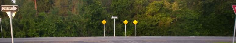
8 Qualitative Assessment US 1 at Old Dixie Highway 7 Northbound Approach Photographs Looking north into the intersection along US 1 Looking south from the intersection along US 1


9 Qualitative Assessment US 1 at Old Dixie Highway 8 Southbound Approach Photographs Looking south into the intersection along US 1 Looking north from the intersection along US 1


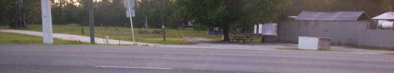
10 Qualitative Assessment US 1 at Old Dixie Highway 9 Westbound Approach Photographs Looking east into the intersection along S Old Dixie Highway Looking west from the intersection along S Old Dixie Highway


11 Qualitative Assessment US 1 at Old Dixie Highway 10 Eastbound Approach Photographs Looking east from the west side of US 1


12 Qualitative Assessment US 1 at Old Dixie Highway 11 Median Photographs Looking west at the median from Trojan Road Looking east at the median from the west side of US 1
13 ONE WAY YIELD NO PARKING ANY TIME 12' 12' 12' 4' YIELD US 1 AT OLD DIXIE HIGHWAY HIGHWAY N E DIVIDED W STOP S ONE WAY ONE WAY HIGHWAY WHITE EAGLE LOUNGE OLD DIXIE HWY US 1 FLAGLER 325 COUNTY STOP OLD DIXIE HIGHWAY 35 POSTED SPEED = 35 MPH SPEED LIMIT STOP DIVIDED TO NORTH 1 YIELD US 1 POSTED SPEED = 65 MPH 30' 4' 12' 12' 12' 346' TOW-AWAY ZONE UNAUTHORIZEDVEHICLES OR VESSELS WILLBE TOWED ATOWNER'S EXPENSE 24 HRS. ADAY7 DAYS AWK. STRICTLYENFORCE STRICTLYENFORCED ORLANDOCITYCODEANDSEC FL.STAT TOWINGISREGULATEDBYCHAPTER39 ASAPTOWING TOWS EVACUATION ROUTE ONE WAY 575' TO ONE WAY NO PARKING ANY TIME 1 SOUTH ONE WAY ONE WAY WOODS ONE WAY FEET 1"=80' TREES SYMBOLS: DELINEATOR DRAINAGE INLETS HEDGE DITCH BOTTOM INLET LIGHT POLE SIGNAL HEAD HYDRANT GAS LINE CONDITION DIAGRAM POWER POLE SIGN TRAFFIC SIGNAL POLE F.O. MITERED END SECTION FIBER OPTIC LINE CONTROLLER CABINET FENCE GUARDRAIL BUILDING MANHOLE DISTRICTWIDE CONTINUING SERVICES FOR TRAFFIC OPERATIONS PAGE NO: 12 $$$$$NAME$$$$$ 7/6/2016 $$$$$$SYTIME$$$$$$ $$$$$$$DGNSPECIFICATION$$$$$$$
14
15 Qualitative Assessment US 1 at S Old Dixie Highway 14 Collision Summary No. Report No Section: Intersecting Street: Source Data: Study Period: Long or Short Form Date Day Time DOB Age Route: US-1 Old Dixie Highway County: Flager Signal 4 Analytics Data / Hard Copy Crash Reports City: Bunnell From 5/31/2015 to 5/31/ Months Alcohol / Drugs Involved Lighting Condition Roadway Surface Weather Fatal Injury Most Severe Injury Harmful Event Property Damage Distracted Contributing Cause Long 06/13/15 Saturday 16:50 4/14/ None Daylight Dry Clear 0 5 Non-incapacitating Right Turn $20,000 N FTYROW Long 10/16/15 Friday 11:15 7/5/ None Daylight Dry Clear 0 2 Non-incapacitating Left Turn $6,000 N Disregarded Stop Sign Long 10/27/15 Tuesday 1:40 8/30/ Alcohol Dark - Not Lighted Dry Cloudy 1 1 Fatal Overturned $16,000 N Careless Driving Long 02/17/16 Wednesday 17:22 1/24/ None Daylight Dry Clear 0 2 Non-incapacitating Rear End $29,000 N Followed Too Closely Long 03/12/16 Saturday 16:28 11/7/ None Daylight Dry Clear 0 2 Incapacitating Overturned $10,000 N FTYROW Long 05/10/16 Tuesday 16:11 7/7/ Alcohol & Drugs Daylight Dry Clear 1 0 Fatal Rear End $15,000 N FTYROW CRASH STATISTICS INJURY SEVERITY LIGHTING ROADWAY CONDITION Total Number of Crashes 6 100% Rear End 2 33% Hit Fence 0 0% No Improper Driving 0 0% Total Number of Long Form Total Property Damage Total Number of Fatalities Number of Fatal Crashes Total Number of Injury of Injuries Number Crashes None Possible Non- Incapacitating Incapacitating Fatal Daylight Dark (SL) Dusk Wet Dry Unknown 6 $96, % -- 33% -- 83% 0% 0% 50% 17% 33% 83% 0% 0% 0% 100% 0% Head On Angle Left Turn Right Turn Sideswipe Backed Into Parked Car Coll W/MV On Road Pedestrian Bike Bike (Bike Lane) Moped Train Animal Hit Sign/Sign Post Hit Utility Pole Hit Guardrail % 0% 17% 17% 0% 0% 0% 0% 0% 0% 0% 0% 0% 0% 0% 0% 0% Hit Concrete Barrier Wall Hit Br/Pier/Abutt Hit Tree/Shrub Hit Const Barricd/SignB r/pier/abutt Traffic Gate Crash Attenuat or Fixed Object Above Road Other Fixed Object Moveable Object Ran Into Ditch/Culvert Ran Off Rd Into Water Overturned Occupant Fell From Vehicle Trac/Trail Jackknifed Fire Explosion All Other % 0% 0% 0% 0% 0% 0% 0% 0% 0% 0% 33% 0% 0% 0% 0% 0% Careless Driving FTYROW Improper Backing Improper Lane Change Improper Turn Followe d Too Closely Disregarded Traffic Signal Exceeded Safe Speed Limit HARMFUL EVENT CONTRIBUTING CAUSE Disregarded Stop Sign Failed to Maintain Equipment Improp er Passin g Drove Left of Center Exceeded Stated Safe Speed Limit Obstructing Traffic Improper Load All Other % 50% 0% 0% 0% 17% 0% 0% 17% 0% 0% 0% 0% 0% 0% 0% 0% Alcohol/Drugs-Under Influence
16
17 Qualitative Assessment US 1 at Old Dixie Highway Appendix
18
19 TURNING MOVEMENT COUNT DATE: 6/2/2016 NORTH STREET: US 1 EAST STREET: OLD DIXIE HIGHWAY SOUTH STREET: US 1 WEST STREET: N/A US 1 AT OLD DIXIE HIGHWAY TIME: 7-9AM,11-1PM,2-6PM ALL VEHICLES BY: DT START NORTHBOUND SOUTHBOUND EASTBOUND WESTBOUND GRAND TIME LEFT THRU RIGHT U-TURN TOTAL LEFT THRU RIGHT U-TURN TOTAL NS TOTAL LEFT THRU RIGHT U-TURN TOTAL LEFT THRU RIGHT U-TURN TOTAL EW TOTAL TOTAL 7: : : : Total , ,286 8: : : : Total , ,105 11: : : : Total : : : : Total : : : : Total : : : : Total , ,186 16: : : : Total , ,254 17: : : : Total , ,323
20 FLORIDA DEPARTMENT OF TRANSPORTATION SUMMARY OF VEHICLE MOVEMENTS SECTION CITY Bunnell COUNTY Flagler STATE ROUTE US 1 INTERSECTING ROUTE Old Dixie Highway OBSERVER DT DATE 6/2/2016 MILEPOST WEATHER Fair ROAD CONDITION Good REMARKS FORM COMPLETED BYBM DATE 07/07/16 US 1 SB ST NAME 2 R T L L 0 0 R N/A EB ST NAME 0 T R T L 1 OLD DIXIE HIGHWAY WB ST NAME L T R 2 US 1 NB ST NAME TIME NORTHBOUND SOUTHBOUND TOTAL EASTBOUND WESTBOUND TOTAL BEGIN/END L T R U TOT L T R U TOT N/S L T R U TOT L T R U TOT E/W , , , , , TOTAL 0 3, , , ,211 7, Percentage 0% 96% 4% 0% 15% 85% 0% 0% 0% 0% 0% 0% 15% 0% 85% 0% Maximum Minimum
21 FLORIDA DEPARTMENT OF TRANSPORTATION PEDESTRIAN MOVEMENT SUMMARY SECTION CITY Bunnell COUNTY Flagler STATE ROUTE US 1 INTERSECTING ROUTE Old Dixie Highway OBSERVER DT DATE 6/2/2016 MILEPOST REMARKS FORM COMPLETED BY BM DATE 07/07/16 US 1 SB ST NAME Total N/A EB ST NAME OLD DIXIE HIGHWAY WB ST NAME Total Total Total US 1 NB ST NAME
22 FLORIDA DEPARTMENT OF TRANSPORTATION BICYCLE MOVEMENT SUMMARY SECTION CITY Bunnell COUNTY Flagler STATE ROUTE US 1 INTERSECTING ROUTE Old Dixie Highway OBSERVER DT DATE 6/2/2016 MILEPOST REMARKS FORM COMPLETED BY BM DATE 07/07/16 US 1 SB ST NAME Total N/A EB ST NAME OLD DIXIE HIGHWAY WB ST NAME Total Total Total US 1 NB ST NAME
Figure 1 Map of intersection of SR 44 (Ravenna Rd) and Butternut Rd
 and Butternut Rd") Abbreviated Study District: 12 County: Geauga Route: SR 44 Section: 1.58 GEA 44 1.58 213 HSP # 47 (Rural Intersection) Prepared April 23, 215 By Bryan Emery Existing Conditions This study contains the
Abbreviated Study District: 12 County: Geauga Route: SR 44 Section: 1.58 GEA 44 1.58 213 HSP # 47 (Rural Intersection) Prepared April 23, 215 By Bryan Emery Existing Conditions This study contains the
Traffic Engineering Study
 Traffic Engineering Study Bellaire Boulevard Prepared For: International Management District Technical Services, Inc. Texas Registered Engineering Firm F-3580 November 2009 Executive Summary has been requested
LAWRENCE TRANSIT CENTER LOCATION ANALYSIS 9 TH STREET & ROCKLEDGE ROAD / 21 ST STREET & IOWA STREET LAWRENCE, KANSAS
 LAWRENCE TRANSIT CENTER LOCATION ANALYSIS 9 TH STREET & ROCKLEDGE ROAD / 21 ST STREET & IOWA STREET LAWRENCE, KANSAS TRAFFIC IMPACT STUDY FEBRUARY 214 OA Project No. 213-542 TABLE OF CONTENTS 1. INTRODUCTION...
Bennett Pit. Traffic Impact Study. J&T Consulting, Inc. Weld County, Colorado. March 3, 2017
 Bennett Pit Traffic Impact Study J&T Consulting, Inc. Weld County, Colorado March 3, 217 Prepared By: Sustainable Traffic Solutions, Inc. http://www.sustainabletrafficsolutions.com/ Joseph L. Henderson,
Proposed location of Camp Parkway Commerce Center. Vicinity map of Camp Parkway Commerce Center Southampton County, VA
 Proposed location of Camp Parkway Commerce Center Vicinity map of Camp Parkway Commerce Center Southampton County, VA Camp Parkway Commerce Center is a proposed distribution and industrial center to be
EXCEPTION TO STANDARDS REPORT
 EXCEPTION TO STANDARDS REPORT PROJECT DESCRIPTION AND NEED The project is located in Section 6, Township 23 North, Range 9 East and Section 31 Township 24 North, Range 9 East, in the Town of Stockton,
MEMO VIA . Ms. Amy Roth DPS Director, City of Three Rivers. To:
 MEMO To: Ms. Amy Roth DPS Director, City of Three Rivers VIA EMAIL From: Michael J. Labadie, PE Julie M. Kroll, PE, PTOE Brandon Hayes, PE, P.Eng. Fleis & VandenBrink Date: January 5, 2017 Re: Proposed
Traffic Impact Study Speedway Gas Station Redevelopment
 Traffic Impact Study Speedway Gas Station Redevelopment Warrenville, Illinois Prepared For: Prepared By: April 11, 2018 Table of Contents 1. Introduction... 1 2. Existing Conditions... 4 Site Location...
2.0 Development Driveways. Movin Out June 2017
 Movin Out June 2017 1.0 Introduction The proposed Movin Out development is a mixed use development in the northeast quadrant of the intersection of West Broadway and Fayette Avenue in the City of Madison.
MERIVALE PRIORITY SQUARE 2852 MERIVALE ROAD CITY OF OTTAWA TRANSPORTATION BRIEF. Prepared for: ONT Inc. 25 Winding Way Nepean, Ontario K2C 3H1
 MERIVALE PRIORITY SQUARE 2852 MERIVALE ROAD CITY OF OTTAWA TRANSPORTATION BRIEF Prepared for: 2190986ONT Inc. 25 Winding Way Nepean, Ontario K2C 3H1 October 6, 2010 110-502 Report_1.doc D. J. Halpenny
IMPROVEMENT CONCEPTS
 IMPROVEMENT CONCEPTS for the South Novato Transit Hub Study Prepared by: January 11, 2010 DKS Associates With Wilbur Smith Associates IMPROVEMENT CONCEPTS Chapter 1: Introduction 1. INTRODUCTION The strategic
TRAFFIC PARKING ANALYSIS
 TRAFFIC PARKING ANALYSIS NAPA FLEA MARKET COUNTY OF NAPA Prepared for: Tom Harding Napa-Vallejo Flea Market 33 Kelly Road American Canyon, CA 9453 Prepared by: 166 Olympic Boulevard, Suite 21 Walnut Creek,
Collision Analysis Safety Tables
 Crash Severity Geography of Geography of Time and Date of Crash Conditions Features Features.. Queries Selected: Town(Hartford), Date(Year:All or //05 to 9/7/06), Severity(All), Route Class(Interstate),
/13/D /14/W /14/D /12/D /16/D /15/D /14/D /18/D /15/D /11/W SR 18
 Windfall Rd SI = 0.18 10-20-13/2/D 08-15-15/14/D 07-16-13/16/D 05-06-15/15/D 01-19-09/12/W 09-29-14/17/D 11-10-09/7/D 01-08-10/7/S 04-26-11/3/W 01-30-10/15/D 12-20-11/14/W 11-16-10/14/W 07-26-08/18/W 07-08-13/15/D
Speed Limit Study: Traffic Engineering Report
 Speed Limit Study: Traffic Engineering Report This report documents the engineering and traffic investigation required by Vermont Statutes Annotated Title 23, Chapter 13 1007 for a municipal legislative
INDUSTRIAL DEVELOPMENT
 INDUSTRIAL DEVELOPMENT Traffic Impact Study Plainfield, Illinois August 2018 Prepared for: Seefried Industrial Properties, Inc. TABLE OF CONTENTS Executive Summary 2 Introduction 3 Existing Conditions
BARRHAVEN FELLOWSHIP CRC 3058 JOCKVALE ROAD OTTAWA, ONTARIO TRANSPORTATION BRIEF. Prepared for:
 BARRHAVEN FELLOWSHIP CRC 3058 JOCKVALE ROAD OTTAWA, ONTARIO TRANSPORTATION BRIEF Prepared for: Barrhaven Fellowship CRC 3058 Jockvale Road Ottawa, ON K2J 2W7 December 7, 2016 116-649 Report_1.doc D. J.
Traffic Accident Statistics
 2000 Missouri State Highway System Traffic Accident Statistics Missouri State Highway System Traffic Accident Statistics Table of Contents Subject Chapter 1: Statewide Traffic Accident Statistics, Introduction
King Soopers #116 Thornton, Colorado
 Traffic Impact Study King Soopers #116 Thornton, Colorado Prepared for: Galloway & Company, Inc. T R A F F I C I M P A C T S T U D Y King Soopers #116 Thornton, Colorado Prepared for Galloway & Company
TRAFFIC IMPACT ANALYSIS FOR. McDONALD S RESTAURANT IN CARMICAEL Sacramento County, CA. Prepared For:
 TRAFFIC IMPACT ANALYSIS FOR McDONALD S RESTAURANT IN CARMICAEL Sacramento County, CA Prepared For: McDonald s USA, LLC Pacific Sierra Region 2999 Oak Road, Suite 900 Walnut Creek, CA 94597 Prepared By:
TRAFFIC IMPACT STUDY FOR SONIC DRIVE-IN RESTAURANT. Vallejo, CA. Prepared For:
 TRAFFIC IMPACT STUDY FOR SONIC DRIVE-IN RESTAURANT Vallejo, CA Prepared For: ELITE DRIVE-INS, INC. 2190 Meridian Park Blvd, Suite G Concord, CA 94520 Prepared By: KD Anderson & Associates 3853 Taylor Road,
DEVELOPMENT PROPERTY 1627 MAXIME STREET CITY OF OTTAWA TRANSPORTATION OVERVIEW. Prepared for: Subhas Bhargava. July 9, Overview_1.
 DEVELOPMENT PROPERTY 1627 MAXIME STREET CITY OF OTTAWA TRANSPORTATION OVERVIEW Prepared for: Subhas Bhargava July 9, 2015 115-620 Overview_1.doc D. J. Halpenny & Associates Ltd. Consulting Transportation
County State Aid Highway 32 (Cliff Road) and Dodd Road Intersection Study
 and Dodd Road Intersection Study") County State Aid Highway 32 (Cliff Road) and Dodd Road Intersection Study City of Eagan, Dakota County, Minnesota Date: March 2012 Project No. 14957.000 444 Cedar Street, Suite 1500 Saint Paul, MN 55101
County State Aid Highway 32 (Cliff Road) and Dodd Road Intersection Study City of Eagan, Dakota County, Minnesota Date: March 2012 Project No. 14957.000 444 Cedar Street, Suite 1500 Saint Paul, MN 55101
Traffic Feasibility Study
 Traffic Feasibility Study Town Center South Robbinsville Township, Mercer County, New Jersey December 19, 2017 Prepared For Robbinsville Township Department of Community Development 2298 Route 33 Robbinsville,
County State Aid Highway 30 (Diffley Road) and Dodd Road Intersection Study
 and Dodd Road Intersection Study") County State Aid Highway 30 (Diffley Road) and Dodd Road Intersection Study City of Eagan, Dakota County, Minnesota Date: March 2012 Project No. 14957.000 444 Cedar Street, Suite 1500 Saint Paul, MN 55101
County State Aid Highway 30 (Diffley Road) and Dodd Road Intersection Study City of Eagan, Dakota County, Minnesota Date: March 2012 Project No. 14957.000 444 Cedar Street, Suite 1500 Saint Paul, MN 55101
GASOLINE SERVICE STATION 1618, 1622 ROGER STEVENS DRIVE OTTAWA, ONTARIO TRANSPORTATION IMPACT ASSESSMENT. Prepared for:
 GASOLINE SERVICE STATION 1618, 1622 ROGER STEVENS DRIVE OTTAWA, ONTARIO TRANSPORTATION IMPACT ASSESSMENT Prepared for: Invecta Development (Ottawa) Corporation 758 Shanks Height Milton, ON L9T 7P7 May
Traffic Impact Statement (TIS)
") Traffic Impact Statement (TIS) Vincentian PUDA Collier County, FL 10/18/2013 Prepared for: Global Properties of Naples Prepared by: Trebilcock Consulting Solutions, PA 2614 Tamiami Trail N, Suite 615 1205
Traffic Impact Statement (TIS) Vincentian PUDA Collier County, FL 10/18/2013 Prepared for: Global Properties of Naples Prepared by: Trebilcock Consulting Solutions, PA 2614 Tamiami Trail N, Suite 615 1205
1999 Missouri State Highway System. Missouri Department of Transportation - Transportation Management Systems
 1999 Missouri State Highway System Traffic Accident Statistics - Transportation Management Systems Missouri State Highway System Traffic Accident Statistics Table of Contents Subject Chapter 1: Statewide
Appendix C-5: Proposed Refinements Rail Operations and Maintenance Facility (ROMF) Traffic Impact Analysis. Durham-Orange Light Rail Transit Project
 Traffic Impact Analysis. Durham-Orange Light Rail Transit Project") Appendix C-5: Proposed Refinements Rail Operations and Maintenance Facility (ROMF) Traffic Impact Analysis Durham-Orange Light Rail Transit Project July 25, 218 ROMF Transportation Impact Analysis Version
Appendix C-5: Proposed Refinements Rail Operations and Maintenance Facility (ROMF) Traffic Impact Analysis Durham-Orange Light Rail Transit Project July 25, 218 ROMF Transportation Impact Analysis Version
Study Area and Location District PSA Ward ANC Phase Description C Planned Suitland Parkway Westbound at Stanton Road Southeast
 Speed Limit and Safety Nexus Studies for Automated Enforcement Locations in the District of Columbia Suitland Parkway at Stanton Road SE Study Area and Location District PSA Ward ANC Phase Description
Date: February 7, 2017 John Doyle, Z-Best Products Robert Del Rio. T.E. Z-Best Traffic Operations and Site Access Analysis
 Memorandum Date: February 7, 07 To: From: Subject: John Doyle, Z-Best Products Robert Del Rio. T.E. Z-Best Traffic Operations and Site Access Analysis Introduction Hexagon Transportation Consultants, Inc.
TIMBERVINE TRANSPORTATION IMPACT STUDY FORT COLLINS, COLORADO JANUARY Prepared for:
 TIMBERVINE TRANSPORTATION IMPACT STUDY FORT COLLINS, COLORADO JANUARY 2014 Prepared for: Hartford Companies 1218 W. Ash Street Suite A Windsor, Co 80550 Prepared by: DELICH ASSOCIATES 2272 Glen Haven Drive
TRAFFIC SIGNAL DESIGN REPORT KING OF PRUSSIA ROAD & RAIDER ROAD RADNOR TOWNSHIP PENNSYLVANIA
 TRAFFIC SIGNAL DESIGN REPORT KING OF PRUSSIA ROAD & RAIDER ROAD RADNOR TOWNSHIP PENNSYLVANIA PREPARED FOR: UNIVERSITY OF PENNSYLVANIA HEALTH SYSTEM 34 CIVIC CENTER BOULEVARD PHILADELPHIA, PA 1987 (61)
USE RESTRICTED 23 USC 409
 Study Map & Totals Legend Fatality Injury Property Damage Remarks: NONE Date Range: 01-01-2010 thru 12-31-2014 2010 2011 2012 Fat Incap Inj Non-Incap Inj Poss Inj PD Tot Fat Incap Inj Non-Incap Inj Poss
RICHMOND OAKS HEALTH CENTRE 6265 PERTH STREET OTTAWA, ONTARIO TRANSPORTATION BRIEF. Prepared for: Guycoki (Eastern) Limited.
 Limited.") RICHMOND OAKS HEALTH CENTRE 6265 PERTH STREET OTTAWA, ONTARIO TRANSPORTATION BRIEF Prepared for: Guycoki (Eastern) Limited June 16, 2016 116-638 Brief_1.doc D. J. Halpenny & Associates Ltd. Consulting
RICHMOND OAKS HEALTH CENTRE 6265 PERTH STREET OTTAWA, ONTARIO TRANSPORTATION BRIEF Prepared for: Guycoki (Eastern) Limited June 16, 2016 116-638 Brief_1.doc D. J. Halpenny & Associates Ltd. Consulting
APPENDIX C1 TRAFFIC ANALYSIS DESIGN YEAR TRAFFIC ANALYSIS
 APPENDIX C1 TRAFFIC ANALYSIS DESIGN YEAR TRAFFIC ANALYSIS DESIGN YEAR TRAFFIC ANALYSIS February 2018 Highway & Bridge Project PIN 6754.12 Route 13 Connector Road Chemung County February 2018 Appendix
TABLE OF CONTENTS. P a g e i
 P a g e i TABLE OF CONTENTS EXECUTIVE SUMMARY... 1 1 INTRODUCTION... 2 2 EXISTING CONDITIONS... 3 3 QUALITATIVE ASSESSMENT... 18 4 IMPROVEMENT CONCEPT... 23 5 CONCLUSION... 27 APPENDIX... 28 Section 79230:
Memorandum. To: Sue Polka, City Engineer, City of Arden Hills. From: Sean Delmore, PE, PTOE. Date: June 21, 2017
 Memorandum engineering planning environmental construction 701 Xenia Avenue South Suite 300 Minneapolis, MN 55416 Tel: 763-541-4800 Fax: 763-541-1700 To: Sue Polka, City Engineer, City of Arden Hills From:
RTE. 1 at RTE. 637 & RTE. 639
 INTERSECTION SAFETY STUDY Prepared for: Virginia Department of Transportation Central Region Operations Traffic Engineering (UPC #81378, TO 12-092) DAVENPORT Project Number: 13-368 / /2014 RTE. 1 at RTE.
Ryan Coyne, PE City Engineer City of Rye 1051 Boston Post Road Rye, NY Boston Post Road Realignment and Roundabout Design Report
 March 6, 2015 Ryan Coyne, PE City Engineer City of Rye 1051 Boston Post Road Rye, NY 10580 RE: JMC Project 14108 Boston Post Road Roundabout Boston Post Road and Parsons Street City of Rye, NY Dear Ryan:
Appendix J Traffic Impact Study
 MRI May 2012 Appendix J Traffic Impact Study Level 2 Traffic Assessment Limited Impact Review Appendix J [This page was left blank intentionally.] www.sgm-inc.com Figure 1. Site Driveway and Trail Crossing
TRAFFIC DATA. Existing Derousse Ave./River Rd. AM LOS Analysis Existing Derousse Ave./River Rd. PM LOS Analysis
 Appendix E NJ TRANSIT Pennsauken Junction Transit Center and Park & Ride RiverLINE and Atlantic City Line Pennsauken Township, Camden County, New Jersey TRAFFIC DATA Background Traffic Information for
Appendix Baseline seats High Retention seats MAIS
 Appendix Table A1: 2001-2008 NASS-CDS crashes with GAD = B and 1992-2008 model year GM vehicles with baseline or high retention seats (n: sample size, se: standard error. Baseline seats High Retention
APPENDIX E. Traffic Analysis Report
 APPENDIX E Traffic Analysis Report THIS PAGE INTENTIONALLY BLANK EAGLE RIVER TRAFFIC MITIGATION PHASE I OLD GLENN HIGHWAY/EAGLE RIVER ROAD INTERSECTION IMPROVEMENTS TRAFFIC ANALYSIS Eagle River, Alaska
L1TILE BEARS DAY CARE TRANSPORTATION IMPACT STUDY FORT COLLINS, COLORADO MAY Prepared for:
 L1TILE BEARS DAY CARE TRANSPORTATION IMPACT STUDY FORT COLLINS, COLORADO MAY 2012 Prepared for: Hillside Construction, Inc. 216 Hemlock Street, Suite B Fort Collins, CO 80534 Prepared by: DELICH ASSOCIATES
Intersection Control Evaluation
 Intersection Control Evaluation Stoltzman Road at Pleasant Street in Mankato, Blue Earth County, Minnesota Mankato/North Mankato Area Planning Organization October 2017 SRF No. 10279 Table of Contents
MILLERSVILLE PARK TRAFFIC IMPACT ANALYSIS ANNE ARUNDEL COUNTY, MARYLAND
 MILLERSVILLE PARK TRAFFIC IMPACT ANALYSIS ANNE ARUNDEL COUNTY, MARYLAND Prepared for: Department of Public Works Anne Arundel County Prepared by: URS Corporation 4 North Park Drive, Suite 3 Hunt Valley,
Proposed CVS/pharmacy
 Traffic Impact and Access Study Proposed CVS/pharmacy West Main Street (Route 1) at Hull Street Clinton, Connecticut PREPARED FOR Arista Development LLC 520 Providence Highway, Suite 9 Norwood, Massachusetts
USE RESTRICTED 23 USC 409
 Created: 04/29/2016 by Randy Woods Study Map & Totals Legend Fatality Injury Property Damage Remarks: NONE Date Range: 01-01-2006 thru 12-31-2015 2006 2007 2008 Fat Incap Inj Non-Incap Inj Poss Inj PD
Traffic Impact Study for the proposed. Town of Allegany, New York. August Project No Prepared For:
 Appendix B SRF Traffic Study (Revised November 2005) Draft Environmental Impact Statement University Commons Town of Allegany, Cattaraugus County, NY December 2005 Traffic Impact Study for the proposed
Section 5.0 Traffic Information
 Section 5.0 Traffic Information 10.0 TRANSPORTATION MDM Transportation Consultants, Inc. (MDM) has prepared an evaluation of transportation impacts for the proposed evaluation for the expansion of the
Department of Highway Safety and Motor Vehicles
 Department of Highway Safety and Motor Vehicles Traffic Report 2005 A Compilation of Motor Vehicle Crash Data from the Florida Crash Records Database Fred O. Dickinson Executive Director Our Mission: Making
Roundabout Feasibility Study SR 44 at Grand Avenue TABLE OF CONTENTS
 Roundabout Feasibility Study SR 44 at Grand Avenue TABLE OF CONTENTS Introduction and Executive Summary... 1 Existing Conditions... 3 Intersection Volume Conditions... 5 Intersection Operations... 9 Safety
TRAFFIC IMPACT ANALYSIS FOR THE 630/650 SOUTH STREET RETAIL DEVELOPMENT WRENTHAM, MASSACHUSETTS
 PARE PROJECT NO. 17120.00 REPORT TRAFFIC IMPACT ANALYSIS FOR THE 630/650 SOUTH STREET RETAIL DEVELOPMENT WRENTHAM, MASSACHUSETTS SUBMITTED TO: GEORGETOWN CAPITAL MANAGEMENT PO BOX 369 GEORGETOWN, MA 01833
ZINFANDEL LANE / SILVERADO TRAIL INTERSECTION TRAFFIC ANALYSIS
 ZINFANDEL LANE / SILVERADO TRAIL INTERSECTION TRAFFIC ANALYSIS UPDATED TRAFFIC STUDY FOR THE PROPOSED RAYMOND VINEYARDS WINERY USE PERMIT MODIFICATION #P11-00156 AUGUST 5, 2014 PREPARED BY: OMNI-MEANS,
Table of Contents INTRODUCTION... 3 PROJECT STUDY AREA Figure 1 Vicinity Map Study Area... 4 EXISTING CONDITIONS... 5 TRAFFIC OPERATIONS...
 Crosshaven Drive Corridor Study City of Vestavia Hills, Alabama Table of Contents INTRODUCTION... 3 PROJECT STUDY AREA... 3 Figure 1 Vicinity Map Study Area... 4 EXISTING CONDITIONS... 5 TRAFFIC OPERATIONS...
CHAPTER 9: VEHICULAR ACCESS CONTROL Introduction and Goals Administration Standards
 9.00 Introduction and Goals 9.01 Administration 9.02 Standards 9.1 9.00 INTRODUCTION AND GOALS City streets serve two purposes that are often in conflict moving traffic and accessing property. The higher
Shirk Road at State Route 198 Interchange Analysis Tulare County, California
 Shirk Road at State Route 198 Interchange Analysis Tulare County, California DRAFT REPORT Prepared By Tulare County Association of Governments (TCAG) April 2013 Table of Contents Introduction:... 3 Project
Speed Limit and Safety Nexus Studies for Automated Enforcement Locations in the District of Columbia 3rd Street Tunnel at Massachusetts Avenue Exit
 Speed Limit and Safety Nexus Studies for Automated Enforcement Locations in the District of Columbia 3rd Street Tunnel at Massachusetts Avenue Exit Study Area and Location District PSA Ward ANC Phase Description
INTERSECTION ANALYSIS PARK AVENUE AND BRADDOCK ROAD (FROSTBURG, MD) FOR LENHART TRAFFIC CONSULTING, INC.
 FOR LENHART TRAFFIC CONSULTING, INC.") INTERSECTION ANALYSIS FOR PARK AVENUE AND BRADDOCK ROAD (FROSTBURG, MD) Prepared for: City of Frostburg, Maryland & Allegany County Commissioners Prepared by: LENHART TRAFFIC CONSULTING, INC. TRAFFIC ENGINEERING
INTERSECTION ANALYSIS FOR PARK AVENUE AND BRADDOCK ROAD (FROSTBURG, MD) Prepared for: City of Frostburg, Maryland & Allegany County Commissioners Prepared by: LENHART TRAFFIC CONSULTING, INC. TRAFFIC ENGINEERING
Traffic Impact Analysis Update
 Willow Bend Traffic Impact Analysis Update TABLE OF CONTENTS Page I. INTRODUCTION -------------------------------------------------------------------------------------------- 1 II. EXISTING CONDITIONS
USE RESTRICTED 23 USC 409
 Created: 06/29/2018 by Lora Koetsier Study Map & Totals Legend Fatality Injury Property Damage Remarks: REQUEST FROM SHELBY TEMPLIN IN SAPM ON 29 JUNE 2018 Date Range: 10-03-2012 thru 10-02-2017 2012 2013
King County Metro. Columbia Street Transit Priority Improvements Alternative Analysis. Downtown Southend Transit Study. May 2014.
 King County Metro Columbia Street Transit Priority Improvements Alternative Analysis Downtown Southend Transit Study May 2014 Parametrix Table of Contents Introduction... 1 Methodology... 1 Study Area...
Traffic Impact Analysis. Alliance Cole Avenue Residential Site Dallas, Texas. Kimley-Horn and Associates, Inc. Dallas, Texas.
 Traffic Impact Analysis Alliance Cole Avenue Residential Site Dallas, Texas February 15, 2018 Kimley-Horn and Associates, Inc. Dallas, Texas Project #064524900 Registered Firm F-928 Traffic Impact Analysis
December 5, Red Bank Planning Board Municipal Building 90 Monmouth Street Red Bank, NJ 07701
 Dynamic Traffic, LLC www.dynamic-traffic.com 1904 Main Street Lake Como, NJ 07719 T. 732.681.0760 December 5, 2016 Red Bank Planning Board Municipal Building 90 Monmouth Street Red Bank, NJ 07701 Re: Traffic
EXECUTIVE SUMMARY. The following is an outline of the traffic analysis performed by Hales Engineering for the traffic conditions of this project.
 EXECUTIVE SUMMARY This study addresses the traffic impacts associated with the proposed Shopko redevelopment located in Sugarhouse, Utah. The Shopko redevelopment project is located between 1300 East and
Wisconsin Motor Vehicle Crash Report. Agency Crash Number Date Arrived 11/17/2017. Total Units 02. School Bus Related No
 Document Number Override Crash Date 11/17/27 Date tified 11/17/27 On Emergency Government Property Reportable Description Diagram Primary Crash Document # Crash Time 4:35 PM Time tified 4:35 PM Hit and
One Harbor Point Residential
 Residential Gig Harbor, WA Transportation Impact Analysis January 23, 2017 Prepared for: Neil Walter Company PO Box 2181 Tacoma, WA 98401 Prepared by: TENW Transportation Engineering NorthWest 11400 SE
ACCIDENT REVIEW FORM
 ACCIDENT REVIEW FORM American Trucking Associations, Inc. Safety Management Council 950 N. Glebe Road, Suite 210, Arlington, VA 22203-4181 Fax: 703-838-1965 E-Mail: JPierce@trucking.org Members of the
TALMONT TOWNHOMES MADISON KENNETH SPA TRAFFIC IMPACT STUDY. Sacramento, CA. Prepared For: MBK Homes. Prepared By:
 TALMONT TOWNHOMES MADISON KENNETH SPA TRAFFIC IMPACT STUDY Sacramento, CA Prepared For: MBK Homes Prepared By: KD Anderson & Associates 3853 Taylor Road, Suite G Loomis, California 95650 (916) 660-1555
City of Marina. Regional Roundabout Study Utilizing Caltrans Intersection Control Evaluation Section 4: Transportation Agency for Monterey County
 Regional Roundabout Study Utilizing Caltrans Intersection Control Evaluation Section 4: City of Marina Study Intersections: RESERVATION ROAD AT BEACH ROAD RESERVATION ROAD AT DEFOREST ROAD CARDOZA AVENUE
Lacey Gateway Residential Phase 1
 Lacey Gateway Residential Phase Transportation Impact Study April 23, 203 Prepared for: Gateway 850 LLC 5 Lake Bellevue Drive Suite 02 Bellevue, WA 98005 Prepared by: TENW Transportation Engineering West
TRAFFIC IMPACT ANALYSIS SHORTBREAD LOFTS 2009 MODIFICATION Chapel Hill, North Carolina
 TRAFFIC IMPACT ANALYSIS SHORTBREAD LOFTS 2009 MODIFICATION Chapel Hill, North Carolina Prepared for: The Town of Chapel Hill, NC Prepared by: Architects-Engineers-Planners, Inc. November 2009 Traffic Impact
Speed Limit and Safety Nexus Studies for Automated Enforcement Locations in the District of Columbia 400 Block 14th Street SW
 Speed Limit and Safety Nexus Studies for Automated Enforcement Locations in the District of Columbia 4 Block 4th Street SW Study Area and Location District PSA Ward ANC Phase Description 27 6 6D Existing
Michigan State Police (MSP) Post 21 - Metro North
 Post 21 - Metro North") October 2017 2016 Reporting Criteria Please pay particular attention to the wording when interpreting the three levels of data gathered for this report. Crash The Crash Level analyzes data related to crash
October 2017 2016 Reporting Criteria Please pay particular attention to the wording when interpreting the three levels of data gathered for this report. Crash The Crash Level analyzes data related to crash
TRAFFIC MANAGEMENT STANDARDS CITY OF GARLAND TRANSPORTATION DEPARTMENT
 TRAFFIC MANAGEMENT STANDARDS CITY OF GARLAND TRANSPORTATION DEPARTMENT JUNE 1996 TABLE OF CONTENTS 1.0 Street Design Standards 1.1 Right-of-Way Requirements 1.2 Median Openings 1.3 Sidewalks 1.4 Traffic
Traffic Impact Analysis West Street Garden Plots Improvements and DuPage River Park Garden Plots Development Naperville, Illinois
 Traffic Impact Analysis West Street Garden Plots Improvements and DuPage River Park Garden Plots Development Naperville, Illinois Submitted by April 9, 2009 Introduction Kenig, Lindgren, O Hara, Aboona,
 Traffic Analysis For Approved Uses within the St. Lucie West DRI Aldi Port St. Lucie, FL Prepared for: Bohler Engineering, LLC 1000 Corporate Drive Suite 250 Fort Lauderdale, FL 33334 Prepared by: 10795
IV. REVISIONS TO THE DRAFT IS/MND
 IV. REVISIONS TO THE DRAFT IS/MND 1. REVISIONS TO THE DRAFT IS/MND This section presents corrections and clarifications that have been made to the text of the Draft IS/MND. These changes include revisions
Safety Assessment. Intersection of Route 29 (Seminole Trail) and Ashwood Blvd (Route 1670). Albemarle County
 and Ashwood Blvd (Route 1670). Albemarle County") Safety Assessment for Intersection of Route 29 (Seminole Trail) and Ashwood Blvd (Route 1670). Albemarle County Prepared by: VIRGINIA DEPARTMENT OF TRANSPORTATION Northwestern Regional Operations - Traffic
Safety Assessment for Intersection of Route 29 (Seminole Trail) and Ashwood Blvd (Route 1670). Albemarle County Prepared by: VIRGINIA DEPARTMENT OF TRANSPORTATION Northwestern Regional Operations - Traffic
TRAFFIC IMPACT ANALYSIS RIZZO CONFERENCE CENTER EXPANSION FINAL REPORT
 TRAFFIC IMPACT ANALYSIS RIZZO CONFERENCE CENTER EXPANSION Chapel Hill, North Carolina FINAL REPORT Prepared for: The Town of Chapel Hill, NC Prepared by: Architects-Engineers-Planners, Inc. December 2010
Study Area and Location District PSA Ward ANC Phase Description B Existing 600 Block New York Avenue Northeast Westbound
 Speed Limit and Safety Nexus Studies for Automated Enforcement Locations in the District of Columbia 6 Block New York Avenue NE Study Area and Location District PSA Ward ANC Phase Description 5 55 5 5B
Understanding and Identifying Crashes on Curves for Safety Improvement Potential in Illinois
 Understanding and Identifying Crashes on Curves for Safety Improvement Potential in Illinois Priscilla Tobias, P.E. Mouyid Islam, Ph.D. Kim Kolody, P.E. Optional Agenda Image Title Background Workflow
Driver Responsibility Points. Arrest Title
 CHART OF MOVING VIOLATIONS The following chart lists the moving violations that are designated by the Texas Department of Public Safety pursuant to statutory authority. The violations listed are subject
Study Area and Location District PSA Ward ANC Phase Description C Proposed 2600 Block Lincoln Road Northeast Northbound
 Speed Limit and Safety Nexus Studies for Automated Enforcement Locations in the District of Columbia 2600 Block Lincoln Road NE Study Area and Location District PSA Ward ANC Phase Description 5 502 5 5C
Corridor Analysis. For COUNTY LINE ROAD (S.R. 1001) CORRIDOR. located in. File No March 2019
 CORRIDOR. located in. File No March 2019") Corridor Analysis For COUNTY LINE ROAD (S.R. 1001) CORRIDOR located in Radnor Township Delaware County Lower Merion Township Montgomery County File No. 16-11060-02 March 2019 Prepared For: Radnor Township
Corridor Analysis For COUNTY LINE ROAD (S.R. 1001) CORRIDOR located in Radnor Township Delaware County Lower Merion Township Montgomery County File No. 16-11060-02 March 2019 Prepared For: Radnor Township
Volume 1 Traffic Impact Analysis Turtle Creek Boulevard Dallas, Texas. Kimley-Horn and Associates, Inc. Dallas, Texas.
 Volume 1 Traffic Impact Analysis 2727 Dallas, Texas June 18, 2018 Kimley-Horn and Associates, Inc. Dallas, Texas Project #064523000 Registered Firm F-928 Traffic Impact Analysis 2727 Dallas, Texas Prepared
Michigan State Police (MSP) Post 21 - Metro North
 Post 21 - Metro North") June 2018 Revised 8/3/2018 2017 Reporting Criteria Please pay particular attention to the wording when interpreting the three levels of data gathered for this report. Crash The Crash Level analyzes data
June 2018 Revised 8/3/2018 2017 Reporting Criteria Please pay particular attention to the wording when interpreting the three levels of data gathered for this report. Crash The Crash Level analyzes data
APPENDIX TR-1 PARKING AND QUEUING ASSESSMENT
 APPENDIX TR-1 PARKING AND QUEUING ASSESSMENT Overland Overland Traffic Consultants, Traffic Consultants, Inc. Inc. Overland Traffic Consultants 952 Manhattan Beach Boulevard, Suite #100 Manhattan Beach,
V. DEVELOPMENT OF CONCEPTS
 Martin Luther King, Jr. Drive Extension FINAL Feasibility Study Page 9 V. DEVELOPMENT OF CONCEPTS Throughout the study process several alternative alignments were developed and eliminated. Initial discussion
Traffic Safety Network Huron Valley
 June 2018 Revised 8/3/2018 2017 Reporting Criteria Please pay particular attention to the wording when interpreting the three levels of data gathered for this report. Crash The Crash Level analyzes data
2 Min. Min. Edge of. Edgeline See Note 3 PLAN VIEW. See Note 3. This distance may vary
 8" Physical gore ( ) ( ) 250 Varies 250 TYPICAL RUMBLE STRIP PLACEMENT AT EXIT AND ENTRANCE RAMPS This distance may vary This distance may vary ( ) 2 16" edge of R=12" Max ( ) Physical gore Texturing 1.
TRAFFIC IMPACT ANALYSIS FOR. Prepared For: Din/Cal 3, Inc Richmond Avenue, Suite 200 Houston, Texas Prepared By:
 TRAFFIC IMPACT ANALYSIS FOR STERLING 5 th STREET APARTMENTS PROJECT Davis, CA Prepared For: Din/Cal 3, Inc. 3411 Richmond Avenue, Suite 200 Houston, Texas 77046 Prepared By: KD Anderson & Associates, Inc.
Evaluation Considerations and Geometric Nuances of Reduced Conflict U-Turn Intersections (RCUTs)
") Evaluation Considerations and Geometric Nuances of Reduced Conflict U-Turn Intersections (RCUTs) 26 th Annual Transportation Research Conference Saint Paul RiverCentre May 20, 2015 Presentation Outline
Evaluation Considerations and Geometric Nuances of Reduced Conflict U-Turn Intersections (RCUTs) 26 th Annual Transportation Research Conference Saint Paul RiverCentre May 20, 2015 Presentation Outline
Traffic Impact Analysis for 2171 Rosecrans Avenue
 Traffic Impact Analysis for 2171 Rosecrans Avenue Prepared for: Continental Development Corporation Revised May 2016 LA16-2831 Prepared by: Fehr & Peers 600 Wilshire Blvd, Suite 1050 Los Angeles, CA 90017
Southern Windsor County 2016 Traffic Count Program Summary April 2017
 Southern Windsor County 2016 Traffic Count Program Summary April 2017 The Southern Windsor County Regional Planning Commission (the RPC ) has been monitoring traffic at 19 locations throughout the southern
Central Park Drives Traffic Management Overview
 Central Park Drives Traffic Management Overview Spring 2015 New York City Department of Transportation Existing Traffic Management From Labor Day thru Last Day of NYC Public School: 8-10 AM weekdays (Southbound)
Study Area and Location District PSA Ward ANC Phase Description A Proposed Monroe Street Northeast Eastbound at Rhode Island Avenue
 Speed Limit and Safety Nexus Studies for Automated Enforcement Locations in the District of Columbia Monroe Street NE and Rhode Island Avenue NE Study Area and Location District PSA Ward ANC Phase Description
LOST LAKE CORRIDOR REVIEW
 LOST LAKE CORRIDOR REVIEW Prepared for: Prepared by: Broadview Developments Inc. c/o Westbrook Consulting Watt Consulting Group Our File: 2064.B01 Date: October 31, 2016 TABLE OF CONTENTS 1.0 INTRODUCTION...
APPENDIX G TRAFFIC STUDY TECHNICAL MEMORANDUM
 APPENDIX G TRAFFIC STUDY TECHNICAL MEMORANDUM TECHNICAL MEMORANDUM To: From: Date: Subject: Jerry Flores - AECOM Brian A. Marchetti, AICP September 9, 5 DRAFT Traffic Study LABOE Channel 5 Studio Relocation