Traffic Impact Analysis
|
|
|
- Alberta Burke
- 5 years ago
- Views:
Transcription

1 Traffic Impact Analysis Congregate Care Facility Billerica, Massachusetts Prepared For: Hawthorn Development, LLC 35 Kettle Court Salem, OR 973 Prepared By: Sebago Technics, Inc. 75 John Roberts Road, Suite 4A South Portland, Maine 46 Sebago Project No. 682 March 5, John Roberts Road Suite 4A, South Portland, ME Fax:
2 Table of Contents Contents Introduction... 3 Existing Conditions... 3 Existing Traffic Volumes... 3 Future No-Build Traffic Volumes... 3 Trip Generation... 7 Trip Distribution and Assignment... 9 Future Build Traffic Volumes... 9 Capacity Analysis... Sight Distance Analysis... 3 Crash Data... 3 Traffic Signal Warrant Analysis... 3 Conclusion... 4 Appendix A. Synchro Reports B. Crash Information C. Traffic Count Data D. Traffic Signal Warrant Analysis E. Canco Woods Traffic Count data Traffic Impact Analysis Congregate Care Facility, Billerica, MA
3 Introduction The purpose of this Preliminary Traffic Impact Analysis (TIA) is to identify the impacts the proposed Congregate Care Facility in Billerica, MA may have on the surrounding area roadways. The project proposes to develop a 5 unit assisted living/retirement facility on the site of an existing golf driving range. The site is proposed to have one full access on Nashua Road approximately 675 feet north of the intersection with Rangeway Road. Existing Conditions Nashua Road (Route 4) at the proposed site driveway is a two-lane roadway classified as an urban minor material with a posted speed limit of 4 miles per hour. The roadway consists of one approximately foot travel lane in each direction separated by a double yellow center line. The roadway has narrow paved shoulders varying in width. The roadway is under the Town of Billerica jurisdiction. The intersection of Nashua Road and Rangeway Road is a two way stop controlled intersection. The Rangeway Road approaches operate under stop control. There is an existing traffic beacon overhead at the intersection displaying a flashing red indication to Rangeway Road and a flashing yellow indication to Nashua Road. Existing Traffic Volumes Turning movement counts were conducted at the intersection of Nashua Road and Rangeway Road on Thursday February 5, 28 for the 3 hour period of 6: AM to 7: PM. The existing volumes were then adjusted to a seasonal factor of.. This factor was taken from 26 Northern Middlesex Traffic Volume Report published by the Northern Middlesex Council of Governments (NMCOG) MPO based upon the MassDOT 26 Weekday Seasonal Factors. The resultant 28 Existing Volumes are shown in Figure. Future No-Build Traffic Volumes The seasonally adjusted 28 traffic volumes were then adjusted to an annual growth factor of.8% to a seven year horizon of 225. This growth factor was based upon NMCOG traffic count station #87. This data was in the previously referenced NMCOG Traffic Volume Report. The future year 225 no-build traffic volumes are shown in Figure 2. Traffic Impact Analysis Congregate Care Facility, Billerica, MA
4 SITE 3 () 786 (65) 5 (2) (76) 25 (4) 4 (27) RANGEWAY ROAD 7 (9) 33 (9) 9 (5) 6 (6) 42 (64) 2 (49) NOTE: NASHUA ROAD COUNTS CONDUCTED ON THURSDAY 2/25/28 FROM 6: AM TO 7: PM RECORDED ACCOUNTS ADJUSTED TO A SEASONAL FACTOR OF. XX (XX) KEY AM PEAK HOUR (7:5-8:5) PM PEAK HOUR OF (5:-6:) 28 EXISTING PEAK HOUR TRAFFIC VOLUMES OF: NASHUA ROAD (ROUTE 4) AT RANGEWAY ROAD, BILLERICA, MA DATE: 2/26/ John Roberts Rd. Suite 4A South Portland, ME 46 Tel SHEET: OF4...\DGN\682_TrafficDiagram.dgn
5 SITE 5 () 89 (74) 9 (4) 2 (86) 48 (45) 7 (3) RANGEWAY ROAD 8 () 37 (22) (6) 7 (8) 48 (726) NASHUA ROAD 23 (56) KEY NOTE: EXISTING TRAFFIC COUNTS FACTORED TO AN ANNUAL GROWTH RATE OF.8% XX (XX) AM PEAK HOUR (7:5-8:5) PM PEAK HOUR OF (5:-6:) 225 NO BUILD PEAK HOUR TRAFFIC VOLUMES OF: NASHUA ROAD (ROUTE 4) AT RANGEWAY ROAD, BILLERICA, MA DATE: 2/26/ John Roberts Rd. Suite 4A South Portland, ME 46 Tel SHEET: 2 OF4...\DGN\682_TrafficDiagram.dgn
6 (2) (29) 5 (4) (8) SITE RANGEWAY ROAD (6) 5 (4) 2 () TRIP GENERATION (PEAK HOUR OF ADJACENT STREET) NASHUA ROAD AM PEAK HOUR ENTERING PM PEAK HOUR 2 KEY EXITING 6 33 XX AM PEAK HOUR (7:5-8:5) TOTAL 7 53 (XX) PM PEAK HOUR OF (5:-6:) PROJECT GENERATED TRIPS OF: NASHUA ROAD (ROUTE 4) AT RANGEWAY ROAD, BILLERICA, MA DATE: 2/26/ John Roberts Rd. Suite 4A South Portland, ME 46 Tel SHEET: 3 OF4...\DGN\682_TrafficDiagram.dgn
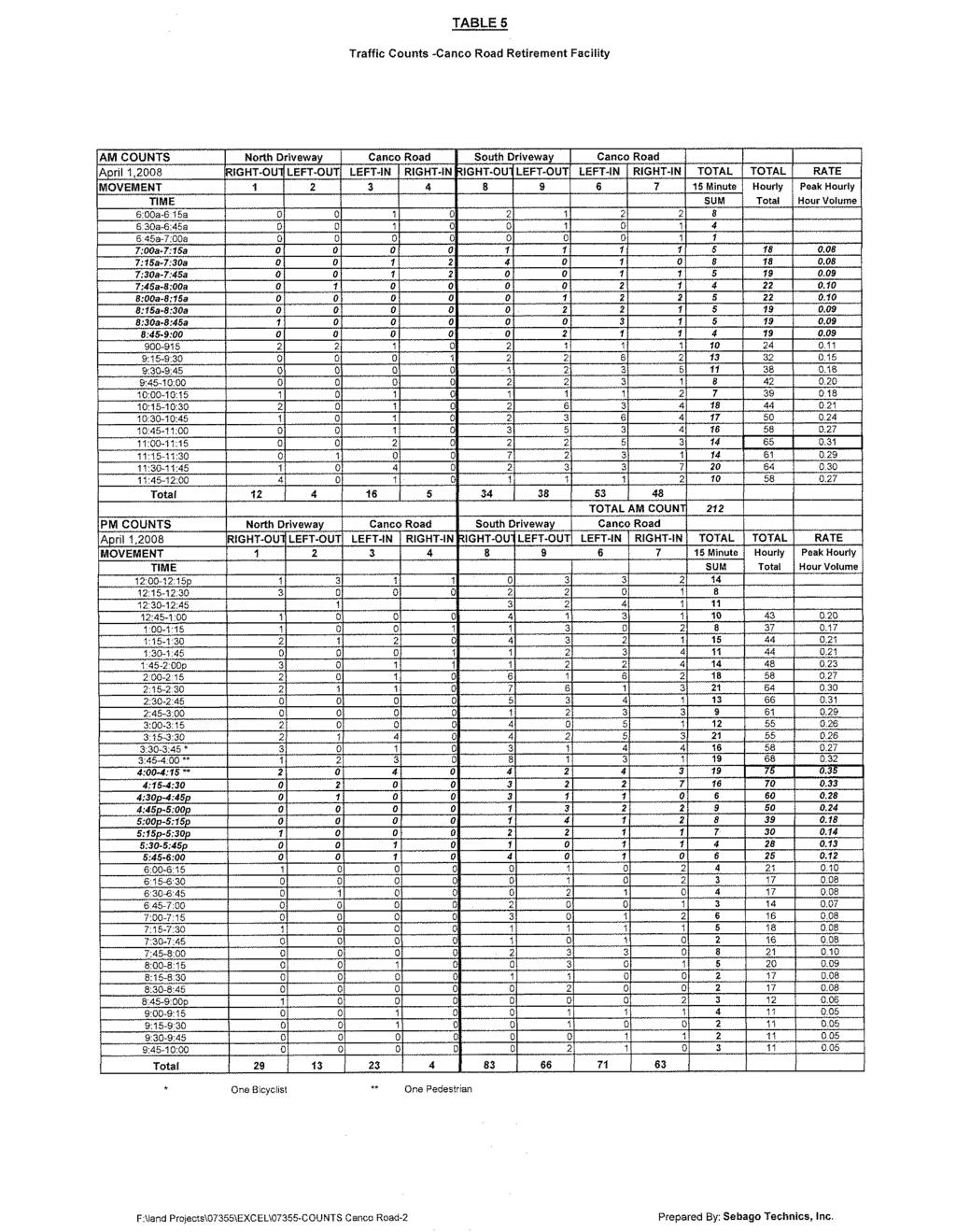
7 Trip Generation Trip generation was initially estimated using the th Edition of the Institute of Transportation Engineers (ITE) Trip Generation Manual. Land Use Codes 253 (Congregate Care Facility) and 254 (Assisted Living) were used. Time Period Table Land Use Code 253 Congregate Care Facility (5 Dwelling Units) Trip Generation Rate/ Total Trips Entering Exiting Dwelling Unit Weekday AM Peak Hour of Adjacent Street (7-9 AM) PM Peak Hour of Adjacent Street (4-6 PM) AM Peak Hour of Generator PM Peak Hour of Generator Time Period Table 2 Land Use Code 254 Assisted Living (66 Dwelling Units) Trip Generation Rate/ Total Trips Entering Exiting Dwelling Unit Weekday AM Peak Hour of Adjacent Street (7-9 AM) PM Peak Hour of Adjacent Street (4-6 PM) AM Peak Hour of Generator PM Peak Hour of Generator Trip generation data was also obtained from a similar facility located in Portland, Maine. The Canco Woods Retirement Facility on Canco Road in Portland was counted on April, 28. The facility at the time consisted of the following: Traffic Impact Analysis Congregate Care Facility, Billerica, MA
8 4 Retirement Suites 8 Assisted Living Suites 2 Cottage Suites 5 Garden Suites Total of 2 Suites The following table shows the recorded peak hour traffic volumes and associated rate. The original turning movement counts can be found attached. Time Period Table 3 Traffic Counts Canco Woods Retirement Facility Total Trips Trip Generation Rate/ Dwelling Unit Weekday AM Peak Hour of Adjacent Street (8-9 AM) PM Peak Hour of Adjacent Street (4-6 PM) AM Peak Hour of Generator PM Peak Hour of Generator As can be seen, the Canco Woods facility is shown to have a slightly higher trip generation rate than that of the ITE Trip Generation Manual. Therefore, to provide a conservative approach, we propose to use this trip generation for the proposed Billerica facility. This facility is projected to have an older resident population than that of Canco Woods, which would logically result in a lesser trip generation rate. The results of this trip generation calculation are shown in Table 4. Directional distribution based on LUC 254 is used. Traffic Impact Analysis Congregate Care Facility, Billerica, MA
9 Time Period Table 4 Proposed Trip Generation (5 Dwelling Units) Trip Generation Rate/ Total Trips Entering Exiting Dwelling Unit Weekday AM Peak Hour of Adjacent Street (7-9 AM) PM Peak Hour of Adjacent Street (4-6 PM) AM Peak Hour of Generator PM Peak Hour of Generator Trip Distribution and Assignment Access to the development is proposed at one full access driveway on Nashua Road. All project generated trips will use this driveway. Trips to and from the development have been distributed and assigned to the roadway network using logical routing based upon the existing traffic volumes. Figure 3 shows the proposed trip distribution and assignment of the project generated trips. Future Build Traffic Volumes Future year 225 build traffic volumes were calculated by adding the project generated trips to the 225 no-build traffic volumes. Figure 4 shows the 225 build traffic Volumes. Traffic Impact Analysis Congregate Care Facility, Billerica, MA
10 25 () (2) (29) 5 (4) 7 (82) (8) SITE 5 () 896 (78) 9 (4) 4 (86) 48 (45) 7 (3) RANGEWAY ROAD 8 () NOTE: VOLUMES FOUND BY ADDING FIGURES 2 AND 3 37 (22) (6) 7 (8) 49 (742) 23 (56) TRIP GENERATION (PEAK HOUR OF ADJACENT STREET) AM PEAK HOUR PM PEAK HOUR ENTERING 2 EXITING 6 33 NASHUA ROAD TOTAL 7 53 KEY XX (XX) AM PEAK HOUR (7:5-8:5) PM PEAK HOUR OF (5:-6:) 225 BUILD PEAK HOUR TRAFFIC VOLUMES OF: NASHUA ROAD (ROUTE 4) AT RANGEWAY ROAD, BILLERICA, MA DATE: 2/26/ John Roberts Rd. Suite 4A South Portland, ME 46 Tel SHEET: 4 OF4...\DGN\682_TrafficDiagram.dgn
11 Capacity Analysis Sebago performed an intersection capacity analysis for the 28 Existing, 225 No-Build and 225 Build Volumes. Synchro was used for this analysis. The focus of our analysis was on the control delay (or the average amount of delay that a vehicle experiences as it travels through an intersection or section of roadway). This is defined by Level of Service (LOS), in terms of A through F, with A being optimal and E/F being unacceptable. HCM 6 methodology was used for the purpose of calculating delay. Table 5 LOS from Control Delay Level of Service (LOS) Unsignalized Control Delay (Sec./Vehicle) Signalized Control Delay (Sec./Vehicle) A B >- 5 >- 2 C >5-25 >2-35 D >25-35 >35-55 E >35-5 >55-8 F >5 >8 Source: Highway Capacity Manual 6 th Edition One existing and one proposed intersection were included in this analysis. This included: Nashua Road at Rangeway Road Nashua Road at Site Driveway (Build Only) The results of the capacity analysis are shown below in Table 6. Traffic Impact Analysis 682 Congregate Care Facility, Billerica, MA
12 Table 6 Capacity Analysis Summary 28 AM 225 AM No Existing Build 225 AM Build Delay Delay Delay LOS LOS (s/veh) (s/veh) (s/veh) LOS Nashua Road at Rangeway Road Nashua Road EB L 8 A B A Nashua Road WB L A 8 A 8 A Rangeway Road NB LTR 39 E 67 F 68 F Rangeway Road SB LTR 8 F 246 F 25 F Nashua Road at Site Drive Nashua Road EB L 7 A Site Drive SB LR 2 C 28 PM Existing Delay LOS (s/veh) 225 PM No Build Delay LOS (s/veh) 225 PM Build Delay (s/veh) Nashua Road at Rangeway Road Nashua Road EB L 9 A A A Nashua Road WB L 7 A 7 A 8 A Rangeway Road NB LTR 24 C 32 D 33 D Rangeway Road SB LTR 33 D 62 F 68 F Nashua Road at Site Drive Nashua Road EB L A Site Drive SB LR 7 C LOS As can be seen in the above table, the Rangeway Road approaches at the Nashua Road intersection have a failing LOS during existing conditions. The addition of project generated traffic is not anticipated to result in a substantial increase in delay for these approaches. The intersection of Sullivan Road and Rangeway Road was not included as part of this capacity analysis. Based upon the turning movement counts at the intersection of Rangeway Road at Nashua Road, the volumes travelling on and turning onto Rangeway Road do not appear to be significant. Coupled with the fact the Sullivan Road is a dead end road, it is not anticipated that the small increase in traffic that Rangeway Road may experience as a result of this project will lead to failing conditions at this location. Traffic Impact Analysis Congregate Care Facility, Billerica, MA
13 Sight Distance Analysis Intersection sight distance was measured at the proposed site driveway in accordance with the procedures outlined in the AASHTO Policy on Geometric Design of Streets and Highways. Table 7 shows the measured sight distance. The sight distance looking to the left could be improved by the removal of several oak trees adjacent to the roadway. Crash Data Table 7 Intersection Sight Distance Measured Sight Distance AASHTO Design Standard* 445 *Based upon Case B- Turn From Stop for a Roadway with Design Speed=4 MPH Crash data was obtained from MassDOT for the most recent three year period (23-25) for the area roadways. Crashes were queried in the general area of the proposed development. Crashes were identified at the following locations: Intersection of Nashua Road and Rangeway Road Crashes Nashua Road in area of Site Driveway Crash No crashes were identified at the intersection of Rangeway Road and Sullivan Road or the surrounding roadway links. The intersection of Nashua Road and Rangeway is calculated to have a crash rate of.93 crashes per million entering vehicles (MEV). The District 4 average for unsignalized intersections is.56 crashes/mev. The majority of crashes were reported as angle collisions as a result of one involved vehicle failing to yield the proper right of way. Traffic Signal Warrant Analysis A traffic signal analysis using the 29 Edition of the MUTCD was completed with the previously mentioned existing traffic volumes. Warrants, 2, 3 and 7 were evaluated for the intersection. Detailed warrant analysis sheets are included in the appendix. In summary, the following are the results of the analysis. Warrant Eight Hour Vehicular Volume Not Met Warrant 2 Four Hour Vehicular Volume - Met Warrant 3 Peak Hour - Met Warrant 7 Crash Experience - Not Met Traffic Impact Analysis Congregate Care Facility, Billerica, MA
14 It is not expected that the addition of project generated traffic will cause Warrants or 2 to be met. A traffic signal warrant analysis was not completed for the intersection of Rangeway Road and Sullivan Road. Based upon the turning movement counts at the intersection of Rangeway Road at Nashua Road, the volumes travelling on and turning onto Rangeway Road do not appear to approach the signal warrant thresholds. Conclusion This Traffic Impact Analysis identifies existing deficiencies related to the intersection of Nashua Road and Rangeway Road in both an operational and safety manner. The proposed development is projected to send a total of 2 trips thru this intersection during the PM Peak Hour. This minor increase in traffic volume is not expected to further deteriorate the operations of this intersection. Traffic Impact Analysis Congregate Care Facility, Billerica, MA
15 Appendix A Synchro Reports
16 HCM 6th TWSC 3: Rangeway Road & Nashua Road 2/27/28 Intersection Int Delay, s/veh 9.5 Movement SEL SET SER NWL NWT NWR NEL NET NER SWL SWT SWR Lane Configurations Traffic Vol, veh/h Future Vol, veh/h Conflicting Peds, #/hr Sign Control Free Free Free Free Free Free Stop Stop Stop Stop Stop Stop RT Channelized - - None - - None - - None - - None Storage Length Veh in Median Storage, # Grade, % Peak Hour Factor Heavy Vehicles, % 2 4 Mvmt Flow Major/Minor Major Major2 Minor Minor2 Conflicting Flow All Stage Stage Critical Hdwy Critical Hdwy Stg Critical Hdwy Stg Follow-up Hdwy Pot Cap- Maneuver Stage Stage Platoon blocked, % Mov Cap- Maneuver Mov Cap-2 Maneuver Stage Stage Approach SE NW NE SW HCM Control Delay, s HCM LOS E F Minor Lane/Major Mvmt NELn NWL NWT NWR SEL SET SERSWLn Capacity (veh/h) HCM Lane V/C Ratio HCM Control Delay (s) HCM Lane LOS E A A - A A - F HCM 95th %tile Q(veh) AM EXISTING 2/27/28 AM EXISTING Synchro Report DHC Page
17 HCM 6th TWSC 3: Rangeway Road & Nashua Road 2/27/28 Intersection Int Delay, s/veh 24.4 Movement SEL SET SER NWL NWT NWR NEL NET NER SWL SWT SWR Lane Configurations Traffic Vol, veh/h Future Vol, veh/h Conflicting Peds, #/hr Sign Control Free Free Free Free Free Free Stop Stop Stop Stop Stop Stop RT Channelized - - None - - None - - None - - None Storage Length Veh in Median Storage, # Grade, % Peak Hour Factor Heavy Vehicles, % 2 4 Mvmt Flow Major/Minor Major Major2 Minor Minor2 Conflicting Flow All Stage Stage Critical Hdwy Critical Hdwy Stg Critical Hdwy Stg Follow-up Hdwy Pot Cap- Maneuver Stage Stage Platoon blocked, % Mov Cap- Maneuver Mov Cap-2 Maneuver Stage Stage Approach SE NW NE SW HCM Control Delay, s HCM LOS F F Minor Lane/Major Mvmt NELn NWL NWT NWR SEL SET SERSWLn Capacity (veh/h) HCM Lane V/C Ratio HCM Control Delay (s) HCM Lane LOS F B A - A A - F HCM 95th %tile Q(veh) No Build AM 2/27/28 No Build AM Synchro Report DHC Page
18 HCM 6th TWSC 3: Rangeway Road & Nashua Road 2/27/28 Intersection Int Delay, s/veh 25. Movement SEL SET SER NWL NWT NWR NEL NET NER SWL SWT SWR Lane Configurations Traffic Vol, veh/h Future Vol, veh/h Conflicting Peds, #/hr Sign Control Free Free Free Free Free Free Stop Stop Stop Stop Stop Stop RT Channelized - - None - - None - - None - - None Storage Length Veh in Median Storage, # Grade, % Peak Hour Factor Heavy Vehicles, % 2 4 Mvmt Flow Major/Minor Major Major2 Minor Minor2 Conflicting Flow All Stage Stage Critical Hdwy Critical Hdwy Stg Critical Hdwy Stg Follow-up Hdwy Pot Cap- Maneuver Stage Stage Platoon blocked, % Mov Cap- Maneuver Mov Cap-2 Maneuver Stage Stage Approach SE NW NE SW HCM Control Delay, s HCM LOS F F Minor Lane/Major Mvmt NELn NWL NWT NWR SEL SET SERSWLn Capacity (veh/h) HCM Lane V/C Ratio HCM Control Delay (s) HCM Lane LOS F B A - A A - F HCM 95th %tile Q(veh) Build AM 2/27/28 Build AM Synchro Report DHC Page
19 HCM 6th TWSC 7: Nashua Road & Site Drive 2/27/28 Intersection Int Delay, s/veh.2 Movement SEL SET NWT NWR SWL SWR Lane Configurations Traffic Vol, veh/h Future Vol, veh/h Conflicting Peds, #/hr Sign Control Free Free Free Free Stop Stop RT Channelized - None - None - None Storage Length Veh in Median Storage, # Grade, % Peak Hour Factor Heavy Vehicles, % Mvmt Flow Major/Minor Major Major2 Minor2 Conflicting Flow All Stage Stage Critical Hdwy Critical Hdwy Stg Critical Hdwy Stg Follow-up Hdwy Pot Cap- Maneuver Stage Stage Platoon blocked, % Mov Cap- Maneuver Mov Cap-2 Maneuver Stage Stage Approach SE NW SW HCM Control Delay, s. 2.3 HCM LOS C Minor Lane/Major Mvmt NWT NWR SEL SETSWLn Capacity (veh/h) HCM Lane V/C Ratio HCM Control Delay (s) HCM Lane LOS - - A A C HCM 95th %tile Q(veh) Build AM 2/27/28 Build AM Synchro Report DHC Page 2
20 HCM 6th TWSC 3: Rangeway Road & Nashua Road 2/27/28 Intersection Int Delay, s/veh 7.8 Movement SEL SET SER NWL NWT NWR NEL NET NER SWL SWT SWR Lane Configurations Traffic Vol, veh/h Future Vol, veh/h Conflicting Peds, #/hr Sign Control Free Free Free Free Free Free Stop Stop Stop Stop Stop Stop RT Channelized - - None - - None - - None - - None Storage Length Veh in Median Storage, # Grade, % Peak Hour Factor Heavy Vehicles, % Mvmt Flow Major/Minor Major Major2 Minor Minor2 Conflicting Flow All Stage Stage Critical Hdwy Critical Hdwy Stg Critical Hdwy Stg Follow-up Hdwy Pot Cap- Maneuver Stage Stage Platoon blocked, % Mov Cap- Maneuver Mov Cap-2 Maneuver Stage Stage Approach SE NW NE SW HCM Control Delay, s HCM LOS C D Minor Lane/Major Mvmt NELn NWL NWT NWR SEL SET SERSWLn Capacity (veh/h) HCM Lane V/C Ratio HCM Control Delay (s) HCM Lane LOS C A A - A A - D HCM 95th %tile Q(veh) Existing PM 2/27/28 Existing PM Synchro Report DHC Page
21 HCM 6th TWSC 3: Rangeway Road & Nashua Road 2/27/28 Intersection Int Delay, s/veh 3.7 Movement SEL SET SER NWL NWT NWR NEL NET NER SWL SWT SWR Lane Configurations Traffic Vol, veh/h Future Vol, veh/h Conflicting Peds, #/hr Sign Control Free Free Free Free Free Free Stop Stop Stop Stop Stop Stop RT Channelized - - None - - None - - None - - None Storage Length Veh in Median Storage, # Grade, % Peak Hour Factor Heavy Vehicles, % Mvmt Flow Major/Minor Major Major2 Minor Minor2 Conflicting Flow All Stage Stage Critical Hdwy Critical Hdwy Stg Critical Hdwy Stg Follow-up Hdwy Pot Cap- Maneuver Stage Stage Platoon blocked, % Mov Cap- Maneuver Mov Cap-2 Maneuver Stage Stage Approach SE NW NE SW HCM Control Delay, s HCM LOS D F Minor Lane/Major Mvmt NELn NWL NWT NWR SEL SET SERSWLn Capacity (veh/h) HCM Lane V/C Ratio HCM Control Delay (s) HCM Lane LOS D A A - A A - F HCM 95th %tile Q(veh) No Build PM 2/27/28 NB PM Synchro Report DHC Page
22 HCM 6th TWSC 3: Rangeway Road & Nashua Road 2/27/28 Intersection Int Delay, s/veh 4.7 Movement SEL SET SER NWL NWT NWR NEL NET NER SWL SWT SWR Lane Configurations Traffic Vol, veh/h Future Vol, veh/h Conflicting Peds, #/hr Sign Control Free Free Free Free Free Free Stop Stop Stop Stop Stop Stop RT Channelized - - None - - None - - None - - None Storage Length Veh in Median Storage, # Grade, % Peak Hour Factor Heavy Vehicles, % Mvmt Flow Major/Minor Major Major2 Minor Minor2 Conflicting Flow All Stage Stage Critical Hdwy Critical Hdwy Stg Critical Hdwy Stg Follow-up Hdwy Pot Cap- Maneuver Stage Stage Platoon blocked, % Mov Cap- Maneuver Mov Cap-2 Maneuver Stage Stage Approach SE NW NE SW HCM Control Delay, s HCM LOS D F Minor Lane/Major Mvmt NELn NWL NWT NWR SEL SET SERSWLn Capacity (veh/h) HCM Lane V/C Ratio HCM Control Delay (s) HCM Lane LOS D A A - A A - F HCM 95th %tile Q(veh) Build PM 2/27/28 Build PM Synchro Report DHC Page
23 HCM 6th TWSC 7: Nashua Road & Site Drive 2/27/28 Intersection Int Delay, s/veh.6 Movement SEL SET NWT NWR SWL SWR Lane Configurations Traffic Vol, veh/h Future Vol, veh/h Conflicting Peds, #/hr Sign Control Free Free Free Free Stop Stop RT Channelized - None - None - None Storage Length Veh in Median Storage, # Grade, % Peak Hour Factor Heavy Vehicles, % Mvmt Flow Major/Minor Major Major2 Minor2 Conflicting Flow All Stage Stage Critical Hdwy Critical Hdwy Stg Critical Hdwy Stg Follow-up Hdwy Pot Cap- Maneuver Stage Stage Platoon blocked, % Mov Cap- Maneuver Mov Cap-2 Maneuver Stage Stage Approach SE NW SW HCM Control Delay, s HCM LOS C Minor Lane/Major Mvmt NWT NWR SEL SETSWLn Capacity (veh/h) HCM Lane V/C Ratio HCM Control Delay (s) HCM Lane LOS - - A A C HCM 95th %tile Q(veh) Build PM 2/27/28 Build PM Synchro Report DHC Page 2
24 Appendix B Crash Information
 North APPROACH : DIRECTION : PEAK HOURLY VOLUMES (AM/PM) : \" K \" FACTOR : TOTAL # OF CRASHES : PEAK HOUR VOLUMES 2 3 4 5 NB SB EB WB 33 43 87 76")
25 INTERSECTION CRASH RATE WORKSHEET CITY/TOWN : Billerica COUNT DATE : 28 DISTRICT : 4 UNSIGNALIZED : X SIGNALIZED : MAJOR STREET : Nashua Road (Route 4) ~ INTERSECTION DATA ~ MINOR STREET(S) : Rangeway Road INTERSECTION DIAGRAM (Label Approaches) North APPROACH : DIRECTION : PEAK HOURLY VOLUMES (AM/PM) : " K " FACTOR : TOTAL # OF CRASHES : PEAK HOUR VOLUMES NB SB EB WB INTERSECTION ADT ( V ) = TOTAL DAILY.9,767 APPROACH VOLUME : 3 AVERAGE # OF CRASHES PER YEAR ( A ) : Total Peak Hourly Approach Volume 3.67 CRASH RATE CALCULATION :.93 RATE = ( A *,, ) ( V * 365 ) Comments : District 4 Avg. for unsignalized intersections =.56 Traffic Volumes from TMC 2/5/28 Project Title & Date: Billerica Retirement 2/28/28
26 Crash Number Crash Date Crash Time Crash Hour City/Town Crash Severity Maximum Injury Severity Reported Number of NonFatal Injuries Number of Fatal Injuries Number of Vehicles Manner of Collision Vehicle Action Prior to Crash Vehicle Travel Directions First Harmful Event First Harmful Event Location Vehicle Sequence of Events Vehicle Configuration Driver Contributing Codes Road Surface Ambient Light Weather Condition Roadway V: Turning left / V2:Travelling straight ahead /28/23 3:48 PM 3:PM to 3:59PM BILLERICA Property damage only (none injured) No injury 2 Sideswipe, same direction V:N / V2:N Collision with motor vehicle in traffic Roadway V: Travelling straight ahead / V2:Travelling straight ahead V:W / V2:S Collision with motor vehicle in traffic Roadway /22/23 5:4 PM 5:PM to 5:59PM BILLERICA Property damage only (none injured) No injury 2 Angle /25/23 4:3 PM 4:PM to 4:59PM BILLERICA Property damage only (none injured) No injury 2 Angle V: Travelling straight ahead / V2:Other V:S / V2:S Collision with motor vehicle in traffic Roadway V: Travelling straight ahead / V2:Slowing or /3/23 9:23 AM 9:AM to 9:59AM BILLERICA Property damage only (none injured) No injury 2 Angle stopped in traffic V:S / V2:E Collision with motor vehicle in traffic Roadway V:(Collision with motor vehicle in traffic) V2:(Collision with motor vehicle in traffic) V:(Collision with motor vehicle in traffic) V2:(Collision with motor vehicle in traffic) V:(Collision with motor vehicle in traffic) V2:(Collision with motor vehicle in traffic) V:(Collision with motor vehicle in traffic) V2:(Collision with motor vehicle in traffic) V:(Passenger car) V2:(Light truck(van, minivan, panel, pickup, sport utility) with only D:(Made an improper turn),(failed to yield four tires) right of way) D2:(No improper driving) Dry Daylight Clear NASHUA ROAD Rte 4 N V:(Light truck(van, mini-van, panel, pickup, sport utility) with only four tires) D:(Visibility obstructed) D2:(No improper V2:(Passenger car) driving) Dry Daylight Clear NASHUA ROAD Rte 4 S / RANGEWAY ROAD V:(Passenger car) V2:(Light truck(van, minivan, panel, pickup, sport utility) with only four tires) D:(Unknown) D2:(Unknown) Dry Daylight Clear NASHUA ROAD Rte 4 S / RANGEWAY ROAD V:(Passenger car) V2:(Light truck(van, minivan, panel, pickup, sport utility) with only D:(No improper driving) D2:(Disregarded four tires) traffic signs, signals, road markings) Dry Daylight Cloudy NASHUA ROAD / RANGEWAY ROAD V:(Collision with motor vehicle in traffic) V2:(Collision with motor vehicle in V:(Light truck(van, mini-van, panel, pickup, traffic),(ran off road right),(collision with sport utility) with only four tires) V2:(Light D:(No improper driving) D2:(Disregarded V: Travelling straight ahead / V2:Turning other fixed object(wall, building, tunnel, truck(van, mini-van, panel, pickup, sport traffic signs, signals, road markings),(failed /28/23 : AM :AM to :59AM BILLERICA Non-fatal injury Non-fatal injury - Non-incapacitating 2 Angle left V:S / V2:W Collision with motor vehicle in traffic Roadway etc.)),(collision with parked motor vehicle) utility) with only four tires) to yield right of way) Dry Daylight Clear NASHUA ROAD / RANGEWAY ROAD D:(Disregarded traffic signs, signals, road V:(Passenger car) V2:(Light truck(van, mini- markings),(failed to yield right of way) V: Travelling straight ahead / V2:Travelling V:(Collision with motor vehicle in traffic) van, panel, pickup, sport utility) with only D2:(No improper driving),(no improper /3/23 :5 AM :AM to :59AM BILLERICA Non-fatal injury Non-fatal injury - Possible 2 2 Angle straight ahead V:W / V2:S Collision with motor vehicle in traffic Roadway V2:(Collision with motor vehicle in traffic) four tires) driving) Dry Daylight Clear NASHUA ROAD / RANGEWAY ROAD V:(Collision with motor vehicle in traffic),(collision with embankment) V:(Light truck(van, mini-van, panel, pickup, V: Travelling straight ahead / V2:Travelling V2:(Collision with motor vehicle in sport utility) with only four tires) D:(No improper driving) D2:(Disregarded /9/24 3:39 PM 3:PM to 3:59PM BILLERICA Property damage only (none injured) No injury 2 Angle straight ahead V:N / V2:W Collision with motor vehicle in traffic Roadway traffic),(collision with tree) V2:(Passenger car) traffic signs, signals, road markings) Wet Daylight Clear NASHUA ROAD / RANGEWAY ROAD /7/24 2:3 PM 2:PM to 2:59PM BILLERICA Property damage only (none injured) No injury 2 Angle //24 2:45 AM 2:AM to 2:59AM BILLERICA Property damage only (none injured) No injury 2 Angle /7/24 5: PM 5:PM to 5:59PM BILLERICA Property damage only (none injured) No injury 2 Angle V: Travelling straight ahead / V2:Entering traffic lane V:S / V2:E Collision with motor vehicle in traffic Roadway V: Travelling straight ahead / V2:Travelling straight ahead V:N / V2:N Collision with motor vehicle in traffic Roadway V: Travelling straight ahead / V2:Not reported V:N / V2:W Collision with motor vehicle in traffic Roadway V:(Collision with motor vehicle in traffic) D:(No improper driving) D2:(Failed to yield V2:(Collision with motor vehicle in traffic) V:(Passenger car) V2:(Passenger car) right of way) Dry Daylight Clear NASHUA ROAD / RANGEWAY ROAD V:(Passenger car) V2:(Light truck(van, minivan, D:(Disregarded traffic signs, signals, road V:(Collision with motor vehicle in traffic) panel, pickup, sport utility) with only markings),(failed to yield right of way) V2:(Collision with motor vehicle in traffic) four tires) D2:(No improper driving) Dry Dark - lighted roadway Clear NASHUA ROAD / RANGEWAY ROAD V:(Collision with motor vehicle in traffic) V2: V:(Tractor/semi-trailer) V2:(Passenger car) D:(No improper driving) D2:() Dry Daylight Clear/Clear NASHUA ROAD / RANGEWAY ROAD V: Travelling straight ahead / V2:Not V:(Collision with motor vehicle in traffic) V:(Light truck(van, mini-van, panel, pickup, /4/24 :33 PM :PM to :59PM BILLERICA Property damage only (none injured) No injury 2 Angle reported V:N / V2:8 Collision with motor vehicle in traffic Roadway V2: sport utility) with only four tires) V2:() D:(No improper driving) D2:() Dry Daylight Clear NASHUA ROAD Rte 4 N / RANGEWAY ROAD V:(Light truck(van, mini-van, panel, pickup, V: Travelling straight ahead / V2:Slowing or V:(Collision with motor vehicle in traffic) sport utility) with only four tires) /2/25 4:5 PM 4:PM to 4:59PM BILLERICA Property damage only (none injured) No injury 2 Angle stopped in traffic V:N / V2:E Collision with motor vehicle in traffic Roadway V2:(Collision with motor vehicle in traffic) V2:(Passenger car) D:() D2:() Dry Daylight Clear/Clear NASHUA ROAD / RANGEWAY ROAD SELECT [Crash Number], [Crash Date], [Crash Time], [Crash Hour], [City/Town], [Crash Severity], [Maximum Injury Severity Reported], [Number of NonFatal Injuries], [Number of Fatal Injuries], [Number of Vehicles], [Manner of Collision], [Vehicle Action Prior to Crash], [Vehicle Travel Directions], [First Harmful Event], [First Harmful Event Location], [Vehicle Sequence of Events], [Vehicle Configuration], [Driver Contributing Codes], [Road Surface], [Ambient Light], [Weather Condition], [Roadway], [Distance And Direction From Intersection], [Near Intersection Roadway], [X], [Y] FROM [TBL_CRASH_REPORT_VIEW] WHERE (([Crash Date] >= '23--' AND [Crash Date] <= '28-2-3') AND ([City/Town] = 'BILLERICA')) This query was also restricted by a map filter.
27 Appendix C Traffic Count Data
28 N/S Street : Rangeway Road E/W Street : Nashua Road City/State : Billerica, MA Weather : Clear File Name : 682 Site Code : 682 Start Date : 2/5/28 Page No : Groups Printed- Cars - Trucks From North From East From South From West Start Time Int. Total 6: AM :5 AM :3 AM :45 AM Total : AM :5 AM :3 AM :45 AM Total : AM :5 AM :3 AM :45 AM Total : AM
29 N/S Street : Rangeway Road E/W Street : Nashua Road City/State : Billerica, MA Weather : Clear File Name : 682 Site Code : 682 Start Date : 2/5/28 Page No : 2 Groups Printed- Cars - Trucks From North From East From South From West Start Time Int. Total 9:5 AM :3 AM :45 AM Total : AM :5 AM :3 AM :45 AM Total : AM :5 AM :3 AM :45 AM Total : PM :5 PM :3 PM :45 PM Total
30 N/S Street : Rangeway Road E/W Street : Nashua Road City/State : Billerica, MA Weather : Clear File Name : 682 Site Code : 682 Start Date : 2/5/28 Page No : 3 Groups Printed- Cars - Trucks From North From East From South From West Start Time Int. Total : PM :5 PM :3 PM :45 PM Total : PM :5 PM :3 PM :45 PM Total : PM :5 PM :3 PM :45 PM Total : PM :5 PM :3 PM
31 N/S Street : Rangeway Road E/W Street : Nashua Road City/State : Billerica, MA Weather : Clear File Name : 682 Site Code : 682 Start Date : 2/5/28 Page No : 4 Groups Printed- Cars - Trucks From North From East From South From West Start Time Int. Total 4:45 PM Total : PM :5 PM :3 PM :45 PM Total : PM :5 PM :3 PM :45 PM Total Grand Total Apprch % Total % Cars % Cars Trucks % Trucks
32 N/S Street : Rangeway Road E/W Street : Nashua Road City/State : Billerica, MA Weather : Clear File Name : 682 Site Code : 682 Start Date : 2/5/28 Page No : 5 From North From East From South From West Start Time App. Total App. Total App. Total App. Total Int. Total Peak Hour Analysis From 6: AM to 9:45 AM - Peak of Peak Hour for Entire Intersection Begins at 7:5 AM 7:5 AM :3 AM :45 AM : AM Total Volume % App. Total PHF Cars % Cars Trucks 2 3 % Trucks
33 N/S Street : Rangeway Road E/W Street : Nashua Road City/State : Billerica, MA Weather : Clear File Name : 682 Site Code : 682 Start Date : 2/5/28 Page No : Peak Hour Data Peak Hour Begins at 7:5 AM Cars Trucks North Peak Hour Analysis From 6: AM to 9:45 AM - Peak of Peak Hour for Each Approach Begins at: 8: AM 8: AM 7:5 AM 7:5 AM + mins mins mins mins Total Volume % App. Total
34 PHF Cars % Cars Trucks 2 2 % Trucks In - Peak Hour: 8: AM Peak Hour Data In - Peak Hour: 7:5 AM Cars Trucks North In - Peak Hour: 8: AM In - Peak Hour: 7:5 AM
35 N/S Street : Rangeway Road E/W Street : Nashua Road City/State : Billerica, MA Weather : Clear File Name : 682 Site Code : 682 Start Date : 2/5/28 Page No : 8 From North From East From South From West Start Time App. Total App. Total App. Total App. Total Int. Total Peak Hour Analysis From : AM to :45 PM - Peak of Peak Hour for Entire Intersection Begins at 2:5 PM 2:5 PM :3 PM :45 PM : PM Total Volume % App. Total PHF Cars % Cars Trucks % Trucks
36 N/S Street : Rangeway Road E/W Street : Nashua Road City/State : Billerica, MA Weather : Clear File Name : 682 Site Code : 682 Start Date : 2/5/28 Page No : Peak Hour Data Peak Hour Begins at 2:5 PM Cars Trucks North Peak Hour Analysis From : AM to :45 PM - Peak of Peak Hour for Each Approach Begins at: : PM 2: PM :45 AM 2:5 PM + mins mins mins mins Total Volume % App. Total
37 PHF Cars % Cars Trucks % Trucks In - Peak Hour: : PM Peak Hour Data In - Peak Hour: 2:5 PM Cars Trucks North In - Peak Hour: 2: PM In - Peak Hour: :45 AM
38 N/S Street : Rangeway Road E/W Street : Nashua Road City/State : Billerica, MA Weather : Clear File Name : 682 Site Code : 682 Start Date : 2/5/28 Page No : From North From East From South From West Start Time App. Total App. Total App. Total App. Total Int. Total Peak Hour Analysis From 2: PM to 6:45 PM - Peak of Peak Hour for Entire Intersection Begins at 5: PM 5: PM :5 PM :3 PM :45 PM Total Volume % App. Total PHF Cars % Cars Trucks 2 2 % Trucks
39 N/S Street : Rangeway Road E/W Street : Nashua Road City/State : Billerica, MA Weather : Clear File Name : 682 Site Code : 682 Start Date : 2/5/28 Page No : Peak Hour Data Peak Hour Begins at 5: PM Cars Trucks North Peak Hour Analysis From 2: PM to 6:45 PM - Peak of Peak Hour for Each Approach Begins at: 4:3 PM 5: PM 3: PM 4: PM + mins mins mins mins Total Volume % App. Total
40 PHF Cars % Cars Trucks 2 % Trucks In - Peak Hour: 4:3 PM Peak Hour Data In - Peak Hour: 4: PM Cars Trucks North In - Peak Hour: 5: PM In - Peak Hour: 3: PM
41 N/S Street : Rangeway Road E/W Street : Nashua Road City/State : Billerica, MA Weather : Clear File Name : 682 Site Code : 682 Start Date : 2/5/28 Page No : 4 Groups Printed- Cars From North From East From South From West Start Time Int. Total 6: AM :5 AM :3 AM :45 AM Total : AM :5 AM :3 AM :45 AM Total : AM :5 AM :3 AM :45 AM Total : AM :5 AM :3 AM
42 N/S Street : Rangeway Road E/W Street : Nashua Road City/State : Billerica, MA Weather : Clear File Name : 682 Site Code : 682 Start Date : 2/5/28 Page No : 5 Groups Printed- Cars From North From East From South From West Start Time Int. Total 9:45 AM Total : AM :5 AM :3 AM :45 AM Total : AM :5 AM :3 AM :45 AM Total : PM :5 PM :3 PM :45 PM Total
43 N/S Street : Rangeway Road E/W Street : Nashua Road City/State : Billerica, MA Weather : Clear File Name : 682 Site Code : 682 Start Date : 2/5/28 Page No : 6 Groups Printed- Cars From North From East From South From West Start Time Int. Total : PM :5 PM :3 PM :45 PM Total : PM :5 PM :3 PM :45 PM Total : PM :5 PM :3 PM :45 PM Total : PM :5 PM :3 PM
44 N/S Street : Rangeway Road E/W Street : Nashua Road City/State : Billerica, MA Weather : Clear File Name : 682 Site Code : 682 Start Date : 2/5/28 Page No : 7 Groups Printed- Cars From North From East From South From West Start Time Int. Total 4:45 PM Total : PM :5 PM :3 PM :45 PM Total : PM :5 PM :3 PM :45 PM Total Grand Total Apprch % Total %
45 N/S Street : Rangeway Road E/W Street : Nashua Road City/State : Billerica, MA Weather : Clear File Name : 682 Site Code : 682 Start Date : 2/5/28 Page No : 8 From North From East From South From West Start Time App. Total App. Total App. Total App. Total Int. Total Peak Hour Analysis From 6: AM to 9:45 AM - Peak of Peak Hour for Entire Intersection Begins at 7:5 AM 7:5 AM :3 AM :45 AM : AM Total Volume % App. Total PHF
46 N/S Street : Rangeway Road E/W Street : Nashua Road City/State : Billerica, MA Weather : Clear File Name : 682 Site Code : 682 Start Date : 2/5/28 Page No : Peak Hour Data Peak Hour Begins at 7:5 AM Cars North Peak Hour Analysis From 6: AM to 9:45 AM - Peak of Peak Hour for Each Approach Begins at: 8: AM 8:3 AM 7:5 AM 7:5 AM + mins mins mins mins Total Volume % App. Total
47 PHF In - Peak Hour: 8: AM Peak Hour Data In - Peak Hour: 7:5 AM Cars North In - Peak Hour: 8:3 AM In - Peak Hour: 7:5 AM
48 N/S Street : Rangeway Road E/W Street : Nashua Road City/State : Billerica, MA Weather : Clear File Name : 682 Site Code : 682 Start Date : 2/5/28 Page No : 2 From North From East From South From West Start Time App. Total App. Total App. Total App. Total Int. Total Peak Hour Analysis From : AM to :45 PM - Peak of Peak Hour for Entire Intersection Begins at 2:5 PM 2:5 PM :3 PM :45 PM : PM Total Volume % App. Total PHF
49 N/S Street : Rangeway Road E/W Street : Nashua Road City/State : Billerica, MA Weather : Clear File Name : 682 Site Code : 682 Start Date : 2/5/28 Page No : Peak Hour Data Peak Hour Begins at 2:5 PM Cars North Peak Hour Analysis From : AM to :45 PM - Peak of Peak Hour for Each Approach Begins at: : PM 2: PM :5 AM 2:5 PM + mins mins mins mins Total Volume % App. Total
50 PHF In - Peak Hour: : PM Peak Hour Data In - Peak Hour: 2:5 PM Cars North In - Peak Hour: 2: PM In - Peak Hour: :5 AM
51 N/S Street : Rangeway Road E/W Street : Nashua Road City/State : Billerica, MA Weather : Clear File Name : 682 Site Code : 682 Start Date : 2/5/28 Page No : 24 From North From East From South From West Start Time App. Total App. Total App. Total App. Total Int. Total Peak Hour Analysis From 2: PM to 6:45 PM - Peak of Peak Hour for Entire Intersection Begins at 5: PM 5: PM :5 PM :3 PM :45 PM Total Volume % App. Total PHF
52 N/S Street : Rangeway Road E/W Street : Nashua Road City/State : Billerica, MA Weather : Clear File Name : 682 Site Code : 682 Start Date : 2/5/28 Page No : Peak Hour Data Peak Hour Begins at 5: PM Cars North Peak Hour Analysis From 2: PM to 6:45 PM - Peak of Peak Hour for Each Approach Begins at: 4:3 PM 5: PM 3: PM 4: PM + mins mins mins mins Total Volume % App. Total
53 PHF In - Peak Hour: 4:3 PM Peak Hour Data In - Peak Hour: 4: PM Cars North In - Peak Hour: 5: PM In - Peak Hour: 3: PM
54 N/S Street : Rangeway Road E/W Street : Nashua Road City/State : Billerica, MA Weather : Clear File Name : 682 Site Code : 682 Start Date : 2/5/28 Page No : 27 Groups Printed- Trucks From North From East From South From West Start Time Int. Total 6: AM 6:5 AM :3 AM 6:45 AM 2 Total 4 4 7: AM 7:5 AM 7:3 AM 7:45 AM Total 3 8: AM 8:5 AM 2 3 8:3 AM 8:45 AM Total 2 4 9: AM 9:5 AM 9:3 AM 2
55 N/S Street : Rangeway Road E/W Street : Nashua Road City/State : Billerica, MA Weather : Clear File Name : 682 Site Code : 682 Start Date : 2/5/28 Page No : 28 Groups Printed- Trucks From North From East From South From West Start Time Int. Total 9:45 AM Total : AM 3 :5 AM 2 :3 AM 2 :45 AM Total : AM 2 :5 AM :3 AM 2 4 :45 AM Total 3 6 2: PM 2:5 PM 2:3 PM 2 2 2:45 PM 2 3 Total 4 6
56 N/S Street : Rangeway Road E/W Street : Nashua Road City/State : Billerica, MA Weather : Clear File Name : 682 Site Code : 682 Start Date : 2/5/28 Page No : 29 Groups Printed- Trucks From North From East From South From West Start Time Int. Total : PM 2 3 :5 PM :3 PM 2 2 :45 PM 4 Total 3 4 2: PM 2 2:5 PM 2 4 2:3 PM 4 5 2:45 PM 6 7 Total : PM 3:5 PM 3:3 PM 3 4 3:45 PM 3 Total : PM 4:5 PM 2 2 4:3 PM
57 N/S Street : Rangeway Road E/W Street : Nashua Road City/State : Billerica, MA Weather : Clear File Name : 682 Site Code : 682 Start Date : 2/5/28 Page No : 3 Groups Printed- Trucks From North From East From South From West Start Time Int. Total 4:45 PM Total 2 4 5: PM 5:5 PM 5:3 PM 2 5:45 PM Total 2 6: PM 6:5 PM 3 6:3 PM 2 6:45 PM 3 Total Grand Total Apprch % Total %
58 N/S Street : Rangeway Road E/W Street : Nashua Road City/State : Billerica, MA Weather : Clear File Name : 682 Site Code : 682 Start Date : 2/5/28 Page No : 3 From North From East From South From West Start Time App. Total App. Total App. Total App. Total Int. Total Peak Hour Analysis From 6: AM to 9:45 AM - Peak of Peak Hour for Entire Intersection Begins at 6: AM 6: AM 6:5 AM :3 AM 6:45 AM 2 Total Volume % App. Total PHF
59 N/S Street : Rangeway Road E/W Street : Nashua Road City/State : Billerica, MA Weather : Clear File Name : 682 Site Code : 682 Start Date : 2/5/28 Page No : Peak Hour Data Peak Hour Begins at 6: AM Trucks North 8 8 Peak Hour Analysis From 6: AM to 9:45 AM - Peak of Peak Hour for Each Approach Begins at: 6: AM 7:3 AM 6: AM 6: AM + mins. +5 mins mins. +45 mins. Total Volume % App. Total
60 PHF In - Peak Hour: 6: AM 6 4 Peak Hour Data In - Peak Hour: 6: AM 4 4 Trucks North In - Peak Hour: 7:3 AM In - Peak Hour: 6: AM
61 N/S Street : Rangeway Road E/W Street : Nashua Road City/State : Billerica, MA Weather : Clear File Name : 682 Site Code : 682 Start Date : 2/5/28 Page No : 34 From North From East From South From West Start Time App. Total App. Total App. Total App. Total Int. Total Peak Hour Analysis From : AM to :45 PM - Peak of Peak Hour for Entire Intersection Begins at : PM : PM :5 PM :3 PM :45 PM 2 4 Total Volume % App. Total PHF
62 N/S Street : Rangeway Road E/W Street : Nashua Road City/State : Billerica, MA Weather : Clear File Name : 682 Site Code : 682 Start Date : 2/5/28 Page No : Peak Hour Data 4 4 Peak Hour Begins at : PM Trucks North Peak Hour Analysis From : AM to :45 PM - Peak of Peak Hour for Each Approach Begins at: : PM 2:3 PM :45 AM : AM + mins mins mins. +45 mins. 2 Total Volume % App. Total
63 PHF In - Peak Hour: : PM 4 3 Peak Hour Data In - Peak Hour: : AM 2 2 Trucks North 5 In - Peak Hour: 2:3 PM 6 In - Peak Hour: :45 AM
64 N/S Street : Rangeway Road E/W Street : Nashua Road City/State : Billerica, MA Weather : Clear File Name : 682 Site Code : 682 Start Date : 2/5/28 Page No : 37 From North From East From South From West Start Time App. Total App. Total App. Total App. Total Int. Total Peak Hour Analysis From 2: PM to 6:45 PM - Peak of Peak Hour for Entire Intersection Begins at 2: PM 2: PM 2 2:5 PM :3 PM :45 PM Total Volume % App. Total PHF
65 N/S Street : Rangeway Road E/W Street : Nashua Road City/State : Billerica, MA Weather : Clear File Name : 682 Site Code : 682 Start Date : 2/5/28 Page No : Peak Hour Data 9 9 Peak Hour Begins at 2: PM Trucks North Peak Hour Analysis From 2: PM to 6:45 PM - Peak of Peak Hour for Each Approach Begins at: 2: PM 2: PM 6: PM 6: PM + mins. +5 mins mins mins. 6 6 Total Volume % App. Total
66 PHF In - Peak Hour: 2: PM 3 2 Peak Hour Data In - Peak Hour: 6: PM 2 Trucks North 6 8 In - Peak Hour: 2: PM In - Peak Hour: 6: PM
67 N/S Street : Rangeway Road E/W Street : Nashua Road City/State : Billerica, MA Weather : Clear File Name : 682 Site Code : 682 Start Date : 2/5/28 Page No : 4 Groups Printed- Bikes Peds From North From East From South From West Start Time Peds Peds Peds Peds Exclu. Total Inclu. Total Int. Total 6: AM 6:5 AM 6:3 AM 6:45 AM Total 7: AM 7:5 AM 7:3 AM 7:45 AM Total 8: AM 8:5 AM 8:3 AM 8:45 AM Total 9: AM 9:5 AM 9:3 AM 9:45 AM Total
68 N/S Street : Rangeway Road E/W Street : Nashua Road City/State : Billerica, MA Weather : Clear File Name : 682 Site Code : 682 Start Date : 2/5/28 Page No : 4 Groups Printed- Bikes Peds From North From East From South From West Start Time Peds Peds Peds Peds Exclu. Total Inclu. Total Int. Total : AM :5 AM :3 AM :45 AM Total : AM :5 AM :3 AM :45 AM Total 2: PM 2:5 PM 2:3 PM 2:45 PM Total 2 2 : PM :5 PM :3 PM :45 PM Total
69 N/S Street : Rangeway Road E/W Street : Nashua Road City/State : Billerica, MA Weather : Clear File Name : 682 Site Code : 682 Start Date : 2/5/28 Page No : 42 Groups Printed- Bikes Peds From North From East From South From West Start Time Peds Peds Peds Peds Exclu. Total Inclu. Total Int. Total 2: PM 2:5 PM 2:3 PM 2:45 PM Total 3: PM 3:5 PM 3:3 PM 3:45 PM Total 4: PM 4:5 PM 4:3 PM 4:45 PM Total 2 5: PM 5:5 PM 5:3 PM 5:45 PM Total
70 N/S Street : Rangeway Road E/W Street : Nashua Road City/State : Billerica, MA Weather : Clear File Name : 682 Site Code : 682 Start Date : 2/5/28 Page No : 43 Groups Printed- Bikes Peds From North From East From South From West Start Time Peds Peds Peds Peds Exclu. Total Inclu. Total Int. Total 6: PM 6:5 PM 6:3 PM 6:45 PM Total Grand Total Apprch % Total %
71 N/S Street : Rangeway Road E/W Street : Nashua Road City/State : Billerica, MA Weather : Clear File Name : 682 Site Code : 682 Start Date : 2/5/28 Page No : 44 From North From East From South From West Start Time App. Total App. Total App. Total App. Total Int. Total Peak Hour Analysis From 6: AM to 9:45 AM - Peak of Peak Hour for Entire Intersection Begins at 6: AM 6: AM 6:5 AM 6:3 AM 6:45 AM Total Volume % App. Total PHF
72 N/S Street : Rangeway Road E/W Street : Nashua Road City/State : Billerica, MA Weather : Clear File Name : 682 Site Code : 682 Start Date : 2/5/28 Page No : 45 Peak Hour Data Peak Hour Begins at 6: AM Bikes Peds North Peak Hour Analysis From 6: AM to 9:45 AM - Peak of Peak Hour for Each Approach Begins at: 6: AM 6: AM 6: AM 6: AM + mins. +5 mins. +3 mins. +45 mins. Total Volume % App. Total
73 PHF In - Peak Hour: 6: AM Peak Hour Data In - Peak Hour: 6: AM Bikes Peds North In - Peak Hour: 6: AM In - Peak Hour: 6: AM
74 N/S Street : Rangeway Road E/W Street : Nashua Road City/State : Billerica, MA Weather : Clear File Name : 682 Site Code : 682 Start Date : 2/5/28 Page No : 47 From North From East From South From West Start Time App. Total App. Total App. Total App. Total Int. Total Peak Hour Analysis From : AM to :45 PM - Peak of Peak Hour for Entire Intersection Begins at 2:5 PM 2:5 PM 2:3 PM 2:45 PM : PM Total Volume % App. Total PHF
75 N/S Street : Rangeway Road E/W Street : Nashua Road City/State : Billerica, MA Weather : Clear File Name : 682 Site Code : 682 Start Date : 2/5/28 Page No : Peak Hour Data Peak Hour Begins at 2:5 PM Bikes Peds North Peak Hour Analysis From : AM to :45 PM - Peak of Peak Hour for Each Approach Begins at: :3 AM : AM 2:5 PM : AM + mins. +5 mins. +3 mins. +45 mins. Total Volume 2 2 % App. Total
76 PHF In - Peak Hour: :3 AM Peak Hour Data In - Peak Hour: : AM Bikes Peds North In - Peak Hour: : AM 2 2 In - Peak Hour: 2:5 PM
77 N/S Street : Rangeway Road E/W Street : Nashua Road City/State : Billerica, MA Weather : Clear File Name : 682 Site Code : 682 Start Date : 2/5/28 Page No : 5 From North From East From South From West Start Time App. Total App. Total App. Total App. Total Int. Total Peak Hour Analysis From 2: PM to 6:45 PM - Peak of Peak Hour for Entire Intersection Begins at 3:3 PM 3:3 PM 3:45 PM 4: PM 4:5 PM Total Volume % App. Total PHF
78 N/S Street : Rangeway Road E/W Street : Nashua Road City/State : Billerica, MA Weather : Clear File Name : 682 Site Code : 682 Start Date : 2/5/28 Page No : 5 Peak Hour Data Peak Hour Begins at 3:3 PM Bikes Peds North Peak Hour Analysis From 2: PM to 6:45 PM - Peak of Peak Hour for Each Approach Begins at: 3:3 PM 2: PM 2: PM 2: PM + mins. +5 mins. +3 mins. +45 mins. Total Volume % App. Total
79 PHF In - Peak Hour: 3:3 PM Peak Hour Data In - Peak Hour: 2: PM Bikes Peds North In - Peak Hour: 2: PM In - Peak Hour: 2: PM
80 Appendix D Traffic Signal Warrant Analysis
81 Traffic Control Signal Warrant Analysis City/Town: Billerica, MA Location: Nashua Road at Rangeway Road Date: 2/26/28 Project No.: 682 Analyst: DHC Summary of Warrant Analysis: Warrant : Warrant 2 Warrant 3 Warrant 7 NO YES YES NO of 6 2/28/28
82 Traffic Control Signal Warrant Analysis Billerica, MA Nashua Road at Rangeway Road Major Steet: Minor Street: Direction: Lanes: 2 EB WB NB SB End Time EB WB Total NB SB Higher : 2: 3: 4: 5: 6: : : : : : : : : : : : : : 2: 2: 22: 23: : Major Street speed exceed 4 MPH: Population less than,: Yes No 2 of 6 2/28/28
83 WARRANT EIGHT HOUR VEHICULAR VOLUME (TABLE 4C- 29 MUTCD) Number of lanes for moving traffic on each approach Major Street Minor Street Condition A Minimum Vehicular Volume Vehicles per hour on major street (total of both approaches) Vehicles per hour on higher-volume minor-street approach (one direction only) % a 8% b 7% c 56% d % a 8% b 7% c 56% d or more or more 2 or more or more Number of lanes for moving traffic on each approach Major Street Minor Street % a 8% b 7% c 56% d % a 8% b 7% c 56% d or more or more 2 or more or more a Basic minimum hourly volume b Used for combination of Conditions A and B after adequate trial of other remedial measures c May be used when the major-street speed exceeds 4 mph or in an isolated community with a population of less than, Condition B Interruption of Continuous Traffic Vehicles per hour on major street (total of both approaches) Vehicles per hour on higher-volume minor-street approach (one direction only) d May be used for combination of Conditions A and B after adequate trial of other remedial measures when the major-street speed exceeds 4 mph or in an isolated community with a population of less than, Warrant Evaluation AND Condition A B A8 B8 : 2: 3: 4: 5: 6: 7: X X 8: X X 9: : : 2: 3: 4: 5: X X 6: X X X X 7: X X X X 8: X 9: 2: 2: 22: 23: : WARRANT MET? NO NO NO 3 of 6 2/28/28
 6 4 2 NO 8 6 4 2 2 3 4 5 6 7 8 MAJOR STREET - TOTAL OF BOTH APPROACHES - 9 2 VEHICLES PER HOUR (VPH) ling Above Applicable Curve: 2 ANT MET?")
84 MINOR STREET HIGHWE VOLUME APPROACH VPH WARRANT 2, FOUR HOUR VEHICULAR VOLUME (7% FACTOR) (COMMUNITY LESS THAN, POPULATION OR ABOVE 4 MPH ON MAJOR STREET) (FIGURE 4C-2 OF 29 MUTCD) NO MAJOR STREET - TOTAL OF BOTH APPROACHES VEHICLES PER HOUR (VPH) ling Above Applicable Curve: 2 ANT MET? YES 4 of 6 2/28/28
 Number of Hours Falling Above Applicable Curve: 8 WARRANT MET?")
85 MINOR STREET HIGHWE VOLUME APPROACH VPH 6 WARRANT 3, PEAK HOUR (7% FACTOR) (COMMUNITY LESS THAN, POPULATION OR ABOVE 4 MPH ON MAJOR STREET) (FIGURE 4C-3 OF 29 MUTCD) 4 NO MAJOR STREET - TOTAL OF BOTH APPROACHES - VEHICLES PER HOUR (VPH) Number of Hours Falling Above Applicable Curve: 8 WARRANT MET? YES 5 of 6 2/28/28
86 WARRANT 7 Crash Experience Number of lanes for moving traffic on each approach Major Street Minor Street Condition A Minimum Vehicular Volume Vehicles per hour on major street (total of both approaches) Vehicles per hour on higher-volume minor-street approach (one direction only) % a 8% b 7% c 56% d % a 8% b 7% c 56% d or more or more 2 or more or more Number of lanes for moving traffic on each approach Major Street Minor Street Condition B Interruption of Continuous Traffic Vehicles per hour on major street (total of both approaches) Vehicles per hour on higher-volume minor-street approach (one direction only) % a 8% b 7% c 56% d % a 8% b 7% c 56% d or more or more 2 or more or more Warrant Evaluation Condition A8 B8 : 2: 3: 4: 5: 6: 7: X 8: X 9: : : 2: 3: 4: 5: X X 6: X X 7: X X 8: X 9: 2: 2: 22: 23: : WARRANT MET? NO NO For each of any 8 hours of an average day, the vehicles per hour (vph) given in both of the 8 percent columns of Condition A in Table 4C- (see Section 4C.2), or the vph in both of the 8 percent columns of Condition B in Table 4C- exists on the major-street and the highervolume minor-street approach, respectively, to the intersection, or the volume of pedestrian traffic is not less than 8 percent of the requirements specified in the Pedestrian Volume warrant. These major-street of 6 2/28/28
87 Appendix E Canco Woods Traffic Count Data
88
Bennett Pit. Traffic Impact Study. J&T Consulting, Inc. Weld County, Colorado. March 3, 2017
 Bennett Pit Traffic Impact Study J&T Consulting, Inc. Weld County, Colorado March 3, 217 Prepared By: Sustainable Traffic Solutions, Inc. http://www.sustainabletrafficsolutions.com/ Joseph L. Henderson,
Ryan Coyne, PE City Engineer City of Rye 1051 Boston Post Road Rye, NY Boston Post Road Realignment and Roundabout Design Report
 March 6, 2015 Ryan Coyne, PE City Engineer City of Rye 1051 Boston Post Road Rye, NY 10580 RE: JMC Project 14108 Boston Post Road Roundabout Boston Post Road and Parsons Street City of Rye, NY Dear Ryan:
APPENDICES. APPENDIX D Synchro Level of Service Output Sheets
 APPENDICES APPENDIX D Synchro Level of Service Output Sheets Lanes, Volumes, Timings NO BUILD 2016 PM 8: 10th St & Thain Rd 10/05/2016 Lane Group NBL NBT NBR SBL SBT SBR SEL SET SER NWL NWT NWR
APPENDICES. No Cumulative Impact Project Alternative Traffic Analysis Memorandum (May 2016)
") APPENDICES Appendix T No Cumulative Impact Project Alternative Traffic Analysis Memorandum (May 2016) 661 Bear Valley Parkway EIR March 2017 APPENDICES This page intentionally left blank 661 Bear Valley
APPENDICES Appendix T No Cumulative Impact Project Alternative Traffic Analysis Memorandum (May 2016) 661 Bear Valley Parkway EIR March 2017 APPENDICES This page intentionally left blank 661 Bear Valley
One Harbor Point Residential
 Residential Gig Harbor, WA Transportation Impact Analysis January 23, 2017 Prepared for: Neil Walter Company PO Box 2181 Tacoma, WA 98401 Prepared by: TENW Transportation Engineering NorthWest 11400 SE
MEMO VIA . Ms. Amy Roth DPS Director, City of Three Rivers. To:
 MEMO To: Ms. Amy Roth DPS Director, City of Three Rivers VIA EMAIL From: Michael J. Labadie, PE Julie M. Kroll, PE, PTOE Brandon Hayes, PE, P.Eng. Fleis & VandenBrink Date: January 5, 2017 Re: Proposed
Weaver Road Senior Housing Traffic Impact Analysis
 Gibson Traffic Consultants, Inc. 2813 Rockefeller Avenue Suite B Everett, WA 9821 425.339.8266 Weaver Road Senior Housing Traffic Impact Analysis Jurisdiction: City of Snohomish January 218 GTC #17-37
Proposed Pit Development
 July 5, 2017 via email: sam@greenwoodconst.ca CCTA File 114239 Sam Greenwood Greenwood Aggregates 205467 County Road 109 Amaranth, ON L9W 0V1 Re: Proposed Violet Hill Gravel Pit, Town of Mono Traffic Review
D & B COMMERCIAL TRAFFIC IMPACT ANALYSIS
 D & B COMMERCIAL TRAFFIC IMPACT ANALYSIS TABLE OF CONTENTS I. Introduction...3 II. Project Description...3 III. Existing Conditions...3 IV. Future Traffic Conditions...8 V. Conclusions and Mitigation...14
Traffic Impact Analysis Update
 Willow Bend Traffic Impact Analysis Update TABLE OF CONTENTS Page I. INTRODUCTION -------------------------------------------------------------------------------------------- 1 II. EXISTING CONDITIONS
JOHNSON RANCH RAPID CITY, SOUTH DAKOTA TRAFFIC IMPACT ANALYSIS
 JOHNSON RANCH RAPID CITY, SOUTH DAKOTA TRAFFIC IMPACT ANALYSIS Prepared for: KTM Design Solutions 528 Kansas City Street, Suite 1 Rapid City, SD 57701 Prepared by: Felsburg Holt & Ullevig 6300 South Syracuse
830 Main Street Halifax Regional Municipality
 830 Main Street Halifax Regional Municipality Traffic Impact Statement Final Report Prepared by: GRIFFIN transportation group inc. 30 Bonny View Drive Fall River, NS B2T 1R2 www.griffininc.ca Prepared
Parking/Traffic Assessment Study
 Brock Road Industrial Mall 985 Brock Road South City of Pickering Parking/Traffic Assessment Study Prepared by: Tranplan Associates, Toronto Toronto 416-670-2005 Sudbury 705-522-0272 Peterborough 705-874-3638
TRAFFIC IMPACT ANALYSIS FOR THE 630/650 SOUTH STREET RETAIL DEVELOPMENT WRENTHAM, MASSACHUSETTS
 PARE PROJECT NO. 17120.00 REPORT TRAFFIC IMPACT ANALYSIS FOR THE 630/650 SOUTH STREET RETAIL DEVELOPMENT WRENTHAM, MASSACHUSETTS SUBMITTED TO: GEORGETOWN CAPITAL MANAGEMENT PO BOX 369 GEORGETOWN, MA 01833
 Traffic Analysis For Approved Uses within the St. Lucie West DRI Aldi Port St. Lucie, FL Prepared for: Bohler Engineering, LLC 1000 Corporate Drive Suite 250 Fort Lauderdale, FL 33334 Prepared by: 10795
Re: Addendum No. 4 Transportation Overview 146 Mountshannon Drive Ottawa, Ontario
 April 18 th, 2017 Mr. Kevin Yemm Vice President, Land Development Richraft Group of Companies 2280 St. Laurent Boulevard, Suite 201 Ottawa, Ontario (Tel: 613.739.7111 / e-mail: keviny@richcraft.com) Re:
TECHNICAL MEMORANDUM
 TECHNICAL MEMORANDUM TO: Merrimack Valley Metropolitan Planning Organization FROM: James Terlizzi, P.E., Transportation Planning Engineer DATE: March 6, 2017 SUBJECT: Further analysis of the recommendations
LOST LAKE CORRIDOR REVIEW
 LOST LAKE CORRIDOR REVIEW Prepared for: Prepared by: Broadview Developments Inc. c/o Westbrook Consulting Watt Consulting Group Our File: 2064.B01 Date: October 31, 2016 TABLE OF CONTENTS 1.0 INTRODUCTION...
June 21, Mr. Jeff Mark The Landhuis Company 212 North Wahsatch Avenue, Suite 301. Colorado Springs, CO 80903
 LSC TRANSPORTATION CONSULTANTS, INC. 545 East Pikes Peak Avenue, Suite 210 Colorado Springs, CO 80903 (719) 633-2868 FAX (719) 633-5430 E-mail: lsc@lsctrans.com Website: http://www.lsctrans.com June 21,
Sweetwater Landing Traffic Impact Analysis
 Gibson Traffic Consultants, Inc. 8 Rockefeller Avenue Suite B Everett, WA 98 45.9.8 Sweetwater Landing Traffic Impact Analysis Jurisdiction: City of Snohomish February 8 GTC #7-87 Sweetwater Landing Traffic
Aldridge Transportation Consultants, LLC Advanced Transportation Planning and Traffic Engineering
 Aldridge Transportation Consultants, LLC Advanced Transportation Planning and Traffic Engineering John M.W. Aldridge, PE, PTOE, AICP 1082 Chimney Rock Road Colorado Registered Professional Engineer Highlands
DRAFT. Kanata Mews Development 329 March Road, City of Ottawa. Transportation Brief. Prepared for:
 Kanata Mews Development Prepared for: Bascorp Management 1611 Ortona Avenue Ottawa, ON K2C 1W4 DRAFT Prepared by: McIntosh Perry Consulting Engineers Ltd. 115 Walgreen Road Carp, ON K0A 1L0 August 19,
APPENDIX A LEVEL OF SERVICE CONCEPTS, ANALYSIS METHODOLOGIES,STANDARDS OF SIGNIFICANCE
 APPENDIX A LEVEL OF SERVICE CONCEPTS, ANALYSIS METHODOLOGIES,STANDARDS OF SIGNIFICANCE Roadway Segment Level of Service Definitions LOS V/C Congestion/Delay Traffic Description (Used for surface streets,
Figure 1 Map of intersection of SR 44 (Ravenna Rd) and Butternut Rd
 and Butternut Rd") Abbreviated Study District: 12 County: Geauga Route: SR 44 Section: 1.58 GEA 44 1.58 213 HSP # 47 (Rural Intersection) Prepared April 23, 215 By Bryan Emery Existing Conditions This study contains the
Abbreviated Study District: 12 County: Geauga Route: SR 44 Section: 1.58 GEA 44 1.58 213 HSP # 47 (Rural Intersection) Prepared April 23, 215 By Bryan Emery Existing Conditions This study contains the
FIRGROVE ELEMENTARY TRAFFIC IMPACT ANALYSIS
 1 FIRGROVE ELEMENTARY TRAFFIC IMPACT ANALYSIS TABLE OF CONTENTS I. Introduction... 3 II. Project Description... 3 III. Existing Conditions... 6 IV. Future Traffic Demand... 10 V. Conclusions and Mitigation...
Date: December 20, Project #:
 To: Craig Rottenberg Long s Jewelers 60A South Avenue Burlington, MA 01803 From: Patrick Dunford, P.E. Senior Project Manager Date: December 20, 2018 Project #: 14416.00 Re: Burlington Mall Proposed Long
Lakeside Terrace Development
 Lakeside Terrace Development City of Barrie, County of Simcoe Traffic Brief for: Type of Document: Final Report Project Number: JDE 1617 Date Submitted: April 29 th, 216 4/29/16 John Northcote, P.Eng.
10 th Street Residences Development Traffic Impact Analysis
 Gibson Traffic Consultants, Inc. 2813 Rockefeller Avenue Suite B Everett, WA 98201 425.339.8266 10 th Street Residences Development Traffic Impact Analysis Jurisdiction: City of Snohomish September 2018
Traffic Generation November 28, Mr. Todd Baker Baker Properties, LLC 953 Islington Street Suite 23D Portsmouth, NH 03801
 28-1932-03 November 28, 2016 Mr. Todd Baker Baker Properties, LLC 953 Islington Street Suite 23D Portsmouth, NH 03801 Re: Traffic Impact Evaluation The Rose Farm Residential Development Exeter, New Hampshire
Sugarland Crossing Gwinnett County, Georgia
 Sugarland Crossing Gwinnett County, Georgia S IGNAL W ARRANT A NALYSIS For the Intersection of: Sugarloaf Parkway / Richards Middle School Driveway / Sugarland Crossing Main Site Driveway Prepared for:
KUM & GO 6400 WESTOWN PARKWAY WEST DES MOINES, IOWA 50266
 KUM & GO #300 PECOS STREET & 88 TH AVENUE THORNTON, COLORADO TRAFFIC IMPACT STUDY REVISION 1 PREPARED FOR KUM & GO 6400 WESTOWN PARKWAY WEST DES MOINES, IOWA 50266 JANUARY 23, 2014 OA PROJECT NO. 013-1721
Traffic Impact Study. Residences at Bancroft Block 14, Lot 2 Borough of Haddonfield, Camden County, New Jersey
 Traffic Impact Study Residences at Bancroft Block 14, Lot 2 April 30, 2018 REVISED: JANUARY 17, 2019 Prepared For 2 Hopkins Lane, LLC 2701 Renaissance Boulevard King of Prussia, PA 19406 Prepared By Maser
Half Moon Bay North Apartment Block Transportation Impact Assessment. Full Report. March 15, Prepared for: Mattamy Homes.
 Half Moon Bay North Apartment Block Transportation Impact Assessment Full Report March 15, 2018 Prepared for: Mattamy Homes Prepared by: Stantec Consulting Ltd. Table of Contents 1.0 SCREENING... 1 1.1
DIVISION STREET PLAT TRAFFIC IMPACT ANALYSIS
 DIVISION STREET PLAT TRAFFIC IMPACT ANALYSIS TABLE OF CONTENTS 1. Introduction...3 2. Project Description...3 3. Existing Conditions...3 4. Forecast Traffic Demand and Analysis...12 5. Conclusions and
FORT MYERS CITY COUNCIL OSCAR M. CORBIN, JR. CITY HALL, 2200 SECOND STREET FORT MYERS, FLORIDA
 Agenda City Council Special Mee ng March 18, 2019 1:00 PM Historic Preserva on Commission Appeal - Virginia Avenue/ McGregor Boulevard Roundabout MAYOR Randall P. Henderson, Jr. Ward 1 Teresa Watkins Brown
Rockingham Ridge Plaza Commercial Development Halifax Regional Municipality
 Rockingham Ridge Plaza Commercial Development Halifax Regional Municipality Traffic Impact Study Final Draft Report Prepared by: GRIFFIN transportation group inc. 30 Bonny View Drive Fall River, NS B2T
Lacey Gateway Residential Phase 1
 Lacey Gateway Residential Phase Transportation Impact Study April 23, 203 Prepared for: Gateway 850 LLC 5 Lake Bellevue Drive Suite 02 Bellevue, WA 98005 Prepared by: TENW Transportation Engineering West
Traffic Engineering Study
 Traffic Engineering Study Bellaire Boulevard Prepared For: International Management District Technical Services, Inc. Texas Registered Engineering Firm F-3580 November 2009 Executive Summary has been requested
Tijuana River Valley Regional Park Campground and Education Center
 Tijuana River Valley Regional Park Campground and Education Center Draft Report September 2018 Prepared for: County of San Diego 5500 Overland Avenue, Suite 410 San Diego, CA 92123 Prepared by: 3900 Fifth
LAWRENCE TRANSIT CENTER LOCATION ANALYSIS 9 TH STREET & ROCKLEDGE ROAD / 21 ST STREET & IOWA STREET LAWRENCE, KANSAS
 LAWRENCE TRANSIT CENTER LOCATION ANALYSIS 9 TH STREET & ROCKLEDGE ROAD / 21 ST STREET & IOWA STREET LAWRENCE, KANSAS TRAFFIC IMPACT STUDY FEBRUARY 214 OA Project No. 213-542 TABLE OF CONTENTS 1. INTRODUCTION...
TRAFFIC SIGNAL DESIGN REPORT KING OF PRUSSIA ROAD & RAIDER ROAD RADNOR TOWNSHIP PENNSYLVANIA
 TRAFFIC SIGNAL DESIGN REPORT KING OF PRUSSIA ROAD & RAIDER ROAD RADNOR TOWNSHIP PENNSYLVANIA PREPARED FOR: UNIVERSITY OF PENNSYLVANIA HEALTH SYSTEM 34 CIVIC CENTER BOULEVARD PHILADELPHIA, PA 1987 (61)
MERIVALE PRIORITY SQUARE 2852 MERIVALE ROAD CITY OF OTTAWA TRANSPORTATION BRIEF. Prepared for: ONT Inc. 25 Winding Way Nepean, Ontario K2C 3H1
 MERIVALE PRIORITY SQUARE 2852 MERIVALE ROAD CITY OF OTTAWA TRANSPORTATION BRIEF Prepared for: 2190986ONT Inc. 25 Winding Way Nepean, Ontario K2C 3H1 October 6, 2010 110-502 Report_1.doc D. J. Halpenny
Aldridge Transportation Consultants, LLC Advanced Transportation Planning and Traffic Engineering
 Aldridge Transportation Consultants, LLC Advanced Transportation Planning and Traffic Engineering John M.W. Aldridge, PE, PTOE, AICP 1082 Chimney Rock Road Colorado Registered Professional Engineer Highlands
Proposed CVS/pharmacy
 Traffic Impact and Access Study Proposed CVS/pharmacy West Main Street (Route 1) at Hull Street Clinton, Connecticut PREPARED FOR Arista Development LLC 520 Providence Highway, Suite 9 Norwood, Massachusetts
Memorandum. To: Sue Polka, City Engineer, City of Arden Hills. From: Sean Delmore, PE, PTOE. Date: June 21, 2017
 Memorandum engineering planning environmental construction 701 Xenia Avenue South Suite 300 Minneapolis, MN 55416 Tel: 763-541-4800 Fax: 763-541-1700 To: Sue Polka, City Engineer, City of Arden Hills From:
Table of Contents. Traffic Impact Analysis Capital One Building at Schilling Place
 Traffic Impact Analysis Capital One Building at Schilling Place Table of Contents Executive Summary... 1 1. Introduction... 4 2. Project Description... 4 3. Background Information... 4 4. Study Scope...
ZINFANDEL LANE / SILVERADO TRAIL INTERSECTION TRAFFIC ANALYSIS
 ZINFANDEL LANE / SILVERADO TRAIL INTERSECTION TRAFFIC ANALYSIS UPDATED TRAFFIC STUDY FOR THE PROPOSED RAYMOND VINEYARDS WINERY USE PERMIT MODIFICATION #P11-00156 AUGUST 5, 2014 PREPARED BY: OMNI-MEANS,
Section 5.0 Traffic Information
 Section 5.0 Traffic Information 10.0 TRANSPORTATION MDM Transportation Consultants, Inc. (MDM) has prepared an evaluation of transportation impacts for the proposed evaluation for the expansion of the
MILLERSVILLE PARK TRAFFIC IMPACT ANALYSIS ANNE ARUNDEL COUNTY, MARYLAND
 MILLERSVILLE PARK TRAFFIC IMPACT ANALYSIS ANNE ARUNDEL COUNTY, MARYLAND Prepared for: Department of Public Works Anne Arundel County Prepared by: URS Corporation 4 North Park Drive, Suite 3 Hunt Valley,
APPENDIX C1 TRAFFIC ANALYSIS DESIGN YEAR TRAFFIC ANALYSIS
 APPENDIX C1 TRAFFIC ANALYSIS DESIGN YEAR TRAFFIC ANALYSIS DESIGN YEAR TRAFFIC ANALYSIS February 2018 Highway & Bridge Project PIN 6754.12 Route 13 Connector Road Chemung County February 2018 Appendix
DEVELOPMENT PROPERTY 1627 MAXIME STREET CITY OF OTTAWA TRANSPORTATION OVERVIEW. Prepared for: Subhas Bhargava. July 9, Overview_1.
 DEVELOPMENT PROPERTY 1627 MAXIME STREET CITY OF OTTAWA TRANSPORTATION OVERVIEW Prepared for: Subhas Bhargava July 9, 2015 115-620 Overview_1.doc D. J. Halpenny & Associates Ltd. Consulting Transportation
L1TILE BEARS DAY CARE TRANSPORTATION IMPACT STUDY FORT COLLINS, COLORADO MAY Prepared for:
 L1TILE BEARS DAY CARE TRANSPORTATION IMPACT STUDY FORT COLLINS, COLORADO MAY 2012 Prepared for: Hillside Construction, Inc. 216 Hemlock Street, Suite B Fort Collins, CO 80534 Prepared by: DELICH ASSOCIATES
MURRIETA APARTMENTS TRAFFIC IMPACT ANALYSIS CITY OF MURRIETA, CALIFORNIA
 MURRIETA APARTMENTS TRAFFIC IMPACT ANALYSIS CITY OF MURRIETA, CALIFORNIA SEPTEMBER 20, 2012 Prepared for: Golden Eagle Multi-Family Properties, LLC 6201 Oak Canyon Rd., Suite 250 Irvine, CA 92618 Prepared
Oakbrook Village Plaza City of Laguna Hills
 Oakbrook Village Plaza City of Laguna Hills Traffic Impact Analysis Prepared by: HDR Engineering 3230 El Camino Real, Suite 200 Irvine, CA 92602 October 2012 Revision 3 D-1 Oakbrook Village Plaza Laguna
Traffic Impact Study Speedway Gas Station Redevelopment
 Traffic Impact Study Speedway Gas Station Redevelopment Warrenville, Illinois Prepared For: Prepared By: April 11, 2018 Table of Contents 1. Introduction... 1 2. Existing Conditions... 4 Site Location...
King Soopers #116 Thornton, Colorado
 Traffic Impact Study King Soopers #116 Thornton, Colorado Prepared for: Galloway & Company, Inc. T R A F F I C I M P A C T S T U D Y King Soopers #116 Thornton, Colorado Prepared for Galloway & Company
INTERSECTION ANALYSIS PARK AVENUE AND BRADDOCK ROAD (FROSTBURG, MD) FOR LENHART TRAFFIC CONSULTING, INC.
 FOR LENHART TRAFFIC CONSULTING, INC.") INTERSECTION ANALYSIS FOR PARK AVENUE AND BRADDOCK ROAD (FROSTBURG, MD) Prepared for: City of Frostburg, Maryland & Allegany County Commissioners Prepared by: LENHART TRAFFIC CONSULTING, INC. TRAFFIC ENGINEERING
INTERSECTION ANALYSIS FOR PARK AVENUE AND BRADDOCK ROAD (FROSTBURG, MD) Prepared for: City of Frostburg, Maryland & Allegany County Commissioners Prepared by: LENHART TRAFFIC CONSULTING, INC. TRAFFIC ENGINEERING
MEMORANDUM. Date: November 4, Cheryl Burrell, Pebble Beach Company. Rob Rees, P.E. Inclusionary Housing Transportation Analysis WC
 MEMORANDUM Date: November 4, 2013 To: From: Subject: Cheryl Burrell, Pebble Beach Company Rob Rees, P.E. Inclusionary Housing Transportation Analysis As requested, Fehr & Peers is providing clarification
EXECUTIVE SUMMARY. The following is an outline of the traffic analysis performed by Hales Engineering for the traffic conditions of this project.
 EXECUTIVE SUMMARY This study addresses the traffic impacts associated with the proposed Shopko redevelopment located in Sugarhouse, Utah. The Shopko redevelopment project is located between 1300 East and
Memorandum. Megan Costa, SOCPA Sam Gordon, Town of DeWitt Jeanie Gleisner, CNYRPDB Meghan Vitale DATE: April 20, 2017
 TO: FROM: Megan Costa, SOCPA Sam Gordon, Town of DeWitt Jeanie Gleisner, CNYRPDB Meghan Vitale DATE: April 20, 2017 RE: Syracuse Metropolitan Transportation Council 100 Clinton Square 126 N. Salina Street,
December 5, Red Bank Planning Board Municipal Building 90 Monmouth Street Red Bank, NJ 07701
 Dynamic Traffic, LLC www.dynamic-traffic.com 1904 Main Street Lake Como, NJ 07719 T. 732.681.0760 December 5, 2016 Red Bank Planning Board Municipal Building 90 Monmouth Street Red Bank, NJ 07701 Re: Traffic
Appendix C-5: Proposed Refinements Rail Operations and Maintenance Facility (ROMF) Traffic Impact Analysis. Durham-Orange Light Rail Transit Project
 Traffic Impact Analysis. Durham-Orange Light Rail Transit Project") Appendix C-5: Proposed Refinements Rail Operations and Maintenance Facility (ROMF) Traffic Impact Analysis Durham-Orange Light Rail Transit Project July 25, 218 ROMF Transportation Impact Analysis Version
Appendix C-5: Proposed Refinements Rail Operations and Maintenance Facility (ROMF) Traffic Impact Analysis Durham-Orange Light Rail Transit Project July 25, 218 ROMF Transportation Impact Analysis Version
CHAPTER 9: VEHICULAR ACCESS CONTROL Introduction and Goals Administration Standards
 9.00 Introduction and Goals 9.01 Administration 9.02 Standards 9.1 9.00 INTRODUCTION AND GOALS City streets serve two purposes that are often in conflict moving traffic and accessing property. The higher
Intersection Control Evaluation
 Intersection Control Evaluation Stoltzman Road at Pleasant Street in Mankato, Blue Earth County, Minnesota Mankato/North Mankato Area Planning Organization October 2017 SRF No. 10279 Table of Contents
TRAFFIC IMPACT ANALYSIS
 TRAFFIC IMPACT ANALYSIS Emerald Isle Commercial Development Prepared by SEPI Engineering & Construction Prepared for Ark Consulting Group, PLLC March 2016 I. Executive Summary A. Site Location The Emerald
Traffic Impact Study for the proposed. Town of Allegany, New York. August Project No Prepared For:
 Appendix B SRF Traffic Study (Revised November 2005) Draft Environmental Impact Statement University Commons Town of Allegany, Cattaraugus County, NY December 2005 Traffic Impact Study for the proposed
Proposed location of Camp Parkway Commerce Center. Vicinity map of Camp Parkway Commerce Center Southampton County, VA
 Proposed location of Camp Parkway Commerce Center Vicinity map of Camp Parkway Commerce Center Southampton County, VA Camp Parkway Commerce Center is a proposed distribution and industrial center to be
Appendix F. Capacity Analysis Worksheets No Build
 Appendix F Capacity Analysis Worksheets No Build 88 9: Rte 35 & Rte 58 WB Off & Rte 58 WB On 7/5/2014 Movement NBL2 NBL NBR SEL SER NEL NET NER SWL SWT SWR Volume (veh/h) 95 0 10 0 0 10 188 0 0 225 38
INTERSECTION CONTROL EVALUATION
 INTERSECTION CONTROL EVALUATION Trunk Highway 22 and CSAH 21 (E Hill Street/Shanaska Creek Road) Kasota, Le Sueur County, Minnesota November 2018 Trunk Highway 22 and Le Sueur CSAH 21 (E Hill Street/Shanaska
APPENDIX G. Traffic Data
 APPENDIX G Traffic Data HCM Signalized Intersection Capacity Analysis 2: Duanesburg Road & I-88 Ramps 10/7/2004 Movement EBL EBT EBR WBL WBT WBR NBL NBT NBR SBL SBT SBR Lane Configurations Ideal Flow (vphpl)
Shirk Road at State Route 198 Interchange Analysis Tulare County, California
 Shirk Road at State Route 198 Interchange Analysis Tulare County, California DRAFT REPORT Prepared By Tulare County Association of Governments (TCAG) April 2013 Table of Contents Introduction:... 3 Project
RESPONSE TO TRAFFIC IMPACT STUDY COMMENTS
 RESPONSE TO TRAFFIC IMPACT STUDY COMMENTS Proposed Gas Station 40 Arthur Street (Highway 26), Town of the Blue Mountains (Thornbury), County of Grey, Ontario AUGUST 2013 August 27, 2013 MR. REG RUSSWURM
Letter of Transmittal
 Letter of Transmittal To: Chris Lovell City of Richmond Hill Date: 5/2/6 Job 2582 Re: Richmond Hill-South Bryan County Transportation STudy WE ARE SENDING YOU THE FOLLOWING ITEMS ( attached) ( under separate
TRAFFIC IMPACT ANALYSIS FOR. McDONALD S RESTAURANT IN CARMICAEL Sacramento County, CA. Prepared For:
 TRAFFIC IMPACT ANALYSIS FOR McDONALD S RESTAURANT IN CARMICAEL Sacramento County, CA Prepared For: McDonald s USA, LLC Pacific Sierra Region 2999 Oak Road, Suite 900 Walnut Creek, CA 94597 Prepared By:
Transportation & Traffic Engineering
 Transportation & Traffic Engineering 1) Project Description This report presents a summary of findings for a Traffic Impact Analysis (TIA) performed by A+ Engineering, Inc. for the Hill Country Family
Speed Limit and Safety Nexus Studies for Automated Enforcement Locations in the District of Columbia 3rd Street Tunnel at Massachusetts Avenue Exit
 Speed Limit and Safety Nexus Studies for Automated Enforcement Locations in the District of Columbia 3rd Street Tunnel at Massachusetts Avenue Exit Study Area and Location District PSA Ward ANC Phase Description
Traffic Impact Statement (TIS)
") Traffic Impact Statement (TIS) Vincentian PUDA Collier County, FL 10/18/2013 Prepared for: Global Properties of Naples Prepared by: Trebilcock Consulting Solutions, PA 2614 Tamiami Trail N, Suite 615 1205
Traffic Impact Statement (TIS) Vincentian PUDA Collier County, FL 10/18/2013 Prepared for: Global Properties of Naples Prepared by: Trebilcock Consulting Solutions, PA 2614 Tamiami Trail N, Suite 615 1205
Proposed Inn at Bellefield Traffic Impact Assessment
 Proposed Inn at Bellefield Traffic Impact Assessment Town of Hyde Park Dutchess County, New York Prepared for: T-Rex Hyde Park Owner LLC 500 Mamroneck Avenue, Suite 300 Harrison, NY 10528 June 21, 2017
VOA Vista Drive Residential housing Development TIA Project #13915 TABLE OF CONTENTS
 VOA Vista Drive Residential housing Development TIA Project #13915 TABLE OF CONTENTS Executive Summary... 2 Project Background... 2 Conditions... 2 Findings... 3 Recommendations... 4 Introduction... 6
Prescott Plaza Traffic Impact Analysis APPENDIX 1.1: APPROVED TRAFFIC STUDY SCOPING AGREEMENT TIA Report.docx
 Prescott Plaza Traffic Impact Analysis APPENDIX 1.1: APPROVED TRAFFIC STUDY SCOPING AGREEMENT 11897-05 TIA Report.docx Prescott Plaza Traffic Impact Analysis This page is intentionally left blank 11897-05
Traffic Impact Study Hudson Street Parking Garage MC Project No.: A Table of Contents
 Traffic Impact Study Hudson Street Parking Garage MC Project No.: 15001714A Table of Contents Table of Contents I. INTRODUCTION... 1 II. EXISTING CONDITIONS... 4 III. 2015 EXISTING TRAFFIC CONDITIONS...
Evaluation Considerations and Geometric Nuances of Reduced Conflict U-Turn Intersections (RCUTs)
") Evaluation Considerations and Geometric Nuances of Reduced Conflict U-Turn Intersections (RCUTs) 26 th Annual Transportation Research Conference Saint Paul RiverCentre May 20, 2015 Presentation Outline
Evaluation Considerations and Geometric Nuances of Reduced Conflict U-Turn Intersections (RCUTs) 26 th Annual Transportation Research Conference Saint Paul RiverCentre May 20, 2015 Presentation Outline
STANDARD LIMITATIONS
 STANDARD LIMITATIONS This report was prepared by MMM Group (MMM) for the account of Spire Construction Inc. (the Client). The disclosure of any information contained in this report is the sole responsibility
RICHMOND OAKS HEALTH CENTRE 6265 PERTH STREET OTTAWA, ONTARIO TRANSPORTATION BRIEF. Prepared for: Guycoki (Eastern) Limited.
 Limited.") RICHMOND OAKS HEALTH CENTRE 6265 PERTH STREET OTTAWA, ONTARIO TRANSPORTATION BRIEF Prepared for: Guycoki (Eastern) Limited June 16, 2016 116-638 Brief_1.doc D. J. Halpenny & Associates Ltd. Consulting
RICHMOND OAKS HEALTH CENTRE 6265 PERTH STREET OTTAWA, ONTARIO TRANSPORTATION BRIEF Prepared for: Guycoki (Eastern) Limited June 16, 2016 116-638 Brief_1.doc D. J. Halpenny & Associates Ltd. Consulting
INTERCHANGE OPERTIONS STUDY Interstate 77 / Wallings Road Interchange
 INTERCHANGE OPERTIONS STUDY Interstate 77 / Wallings Road Interchange City of Broadview Heights, Cuyahoga County, Ohio Prepared For: City of Broadview Heights Department of Engineering 9543 Broadview Road
INDUSTRIAL DEVELOPMENT
 INDUSTRIAL DEVELOPMENT Traffic Impact Study Plainfield, Illinois August 2018 Prepared for: Seefried Industrial Properties, Inc. TABLE OF CONTENTS Executive Summary 2 Introduction 3 Existing Conditions
RTE. 1 at RTE. 637 & RTE. 639
 INTERSECTION SAFETY STUDY Prepared for: Virginia Department of Transportation Central Region Operations Traffic Engineering (UPC #81378, TO 12-092) DAVENPORT Project Number: 13-368 / /2014 RTE. 1 at RTE.
Appendix H: Construction Impacts H-2 Transportation
 Appendix H: Construction Impacts H-2 Transportation \ AECOM 71 W. 23 rd Street New York, NY 10010 www.aecom.com 212 366 6200 tel 212 366 6214 fax Memorandum To CC Subject Robert Conway Donald Tone Construction
1. INTRODUCTION 2. PROJECT DESCRIPTION CUBES SELF-STORAGE MILL CREEK TRIP GENERATION COMPARISON
 CUBES SELF-STORAGE MILL CREEK TRIP GENERATION COMPARISON 1. INTRODUCTION This report summarizes traffic impacts of the proposed CUBES Self-Storage Mill Creek project in comparison to the traffic currently
Traffic Impact Analysis West Street Garden Plots Improvements and DuPage River Park Garden Plots Development Naperville, Illinois
 Traffic Impact Analysis West Street Garden Plots Improvements and DuPage River Park Garden Plots Development Naperville, Illinois Submitted by April 9, 2009 Introduction Kenig, Lindgren, O Hara, Aboona,
Traffic Impact Study Proposed Commercial Development Ballwin, Missouri. Technical Memorandum for Traffic Impact Study
 Traffic Impact Study Proposed Commercial Development Ballwin, Missouri Technical Memorandum for Traffic Impact Study Crawford, Bunte, Brammeier May 1, 2009 MEMORANDUM Date: April 24, 2009 To: From: Subject:
Traffic Impact Analysis. Alliance Cole Avenue Residential Site Dallas, Texas. Kimley-Horn and Associates, Inc. Dallas, Texas.
 Traffic Impact Analysis Alliance Cole Avenue Residential Site Dallas, Texas February 15, 2018 Kimley-Horn and Associates, Inc. Dallas, Texas Project #064524900 Registered Firm F-928 Traffic Impact Analysis
Submittal Document II.G. D-bar-A Project, Traffic Impact Study, prepared by Bergmman Associates, dated November 3, 2015 ( Traffic Study )
") Submittal Document II.G. D-bar-A Project, Traffic Impact Study, prepared by Bergmman Associates, dated November 3, 2015 ( Traffic Study ) D-bar-A Project Traffic Impact Study November 3 rd, 2015 1427
Submittal Document II.G. D-bar-A Project, Traffic Impact Study, prepared by Bergmman Associates, dated November 3, 2015 ( Traffic Study ) D-bar-A Project Traffic Impact Study November 3 rd, 2015 1427
TIMBERVINE TRANSPORTATION IMPACT STUDY FORT COLLINS, COLORADO JANUARY Prepared for:
 TIMBERVINE TRANSPORTATION IMPACT STUDY FORT COLLINS, COLORADO JANUARY 2014 Prepared for: Hartford Companies 1218 W. Ash Street Suite A Windsor, Co 80550 Prepared by: DELICH ASSOCIATES 2272 Glen Haven Drive
886 March Road McDonald's Transportation Study
 McDonald's Restaurants of Canada Limited March 2013 886 March Road McDonald's Transportation Study Submitted by: HDR Corporation 100 York Boulevard, Suite 300 Richmond Hill, ON L4B 1J8 (905) 882-4100 www.hdrinc.com
TRAFFIC DATA. Existing Derousse Ave./River Rd. AM LOS Analysis Existing Derousse Ave./River Rd. PM LOS Analysis
 Appendix E NJ TRANSIT Pennsauken Junction Transit Center and Park & Ride RiverLINE and Atlantic City Line Pennsauken Township, Camden County, New Jersey TRAFFIC DATA Background Traffic Information for
County State Aid Highway 30 (Diffley Road) and Dodd Road Intersection Study
 and Dodd Road Intersection Study") County State Aid Highway 30 (Diffley Road) and Dodd Road Intersection Study City of Eagan, Dakota County, Minnesota Date: March 2012 Project No. 14957.000 444 Cedar Street, Suite 1500 Saint Paul, MN 55101
County State Aid Highway 30 (Diffley Road) and Dodd Road Intersection Study City of Eagan, Dakota County, Minnesota Date: March 2012 Project No. 14957.000 444 Cedar Street, Suite 1500 Saint Paul, MN 55101
1 st Street Intersection Study
 TRAFFIC ENGINEERING ASSISTANCE PROGRAM 1 st Street Intersection Study Prepared for: City of Independence In Cooperation With: Iowa Department of Transportation & Iowa Department of Public Safety Governor
Proposed Hotel and Restaurant Development
 Traffic Impact Study Proposed Hotel and Restaurant Development Marbledale Road Tuckahoe, NY PREPARED FOR BILLWIN DEVELOPMENT AFFILIATES, LLC 365 WHITE PLAINS ROAD EASTCHESTER, NY. 10709 PREPARED BY Engineering
Existing Traffic Conditions
 May 14, 2014 Ms. Lorraine Weiss City of San Mateo 330 West 20 th Avenue San Mateo, CA 94403 Subject: Traffic Operational Study for the Proposed Tilton Avenue Residential Development in San Mateo, California