Chapter 2: Alternatives
|
|
|
- Lindsey Lambert
- 5 years ago
- Views:
Transcription
1 This chapter summarizes the alternatives considered and the process by which alternatives were screened. t also describes the No Action Alternative, the Enhanced Bus Alternative, and the Preferred Alternative. The Utah Transit Authority (UTA) intends to request federal funding under the Federal Transit Administration s (FTA s) Small Starts program; UTA has prepared a separate Alternatives Analysis (AA) report per FTA Small Starts guidance. The AA report, dated October 200, documents the process and analysis used to determine a mode and alignment, resulting in a recommended Locally Preferred Alternative (carried forward as the Preferred Alternative in this document). The AA discusses costs, benefits, environmental impacts, and community impacts for the transit improvements. 2. DEVELOPMENT OF ALTERNATVES A wide range of alternatives was considered to address the transportation needs of the study area. Alternatives that were previously considered in the 2005 Provo Orem Rapid Transit Corridor Feasibility Study were reevaluated, and additional alternatives were developed through technical analysis and the scoping process. The interchange at 800 South and nterstate 5 ( 5) in Orem was not considered at the initiation of the project in December n spring 2009 the lead agencies (which were only FTA and UTA at that time) decided to expand the purpose of the Provo Orem Bus Rapid Transit Project to include addressing the congestion and connectivity needs near 5 and to consider the interchange at 800 South as an alternative in the (EA). At that time the Utah Department of Transportation (UDOT) and the Federal Highway Administration (FHWA), who were cooperating agencies at that time, were invited to become lead agencies. The development of alternatives to address these specific needs is described in Section Community nput nput from the community was critical in identifying and evaluating alternatives to meet the needs of the study area. nput was collected via a range of methods including implementing a formal scoping process, forming stakeholder groups, and meeting with city representatives and the public. The scoping period for the Provo Orem Bus Rapid Transit EA was between December 2, 2007, and February 28, Comments were received via an agency meeting (January 23, 2008), a public meeting (January 24, 2008), the project Website, and agency letters. nput collected during the scoping period assisted in refining the project purpose and need, identifying an initial set of alternatives, and identifying potential environmental impacts associated with the project. Additional public outreach and scoping was conducted when the lead agencies expanded the purpose of the project to address congestion and connectivity issues associated with interchanges on 5. Chapter 8 summarizes the input collected during the scoping period and the subsequent 800 South outreach activities. Public involvement summary reports are located on the project Website at oremrapidtransit.info. 4/2/20 Page 2-
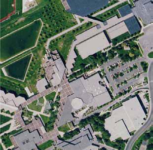
2 A policy committee was created to gather input from key stakeholders. The policy committee was comprised of staff from Mountainland Association of Governments (MAG), UTA, UDOT, Orem City, Provo City, Brigham Young University (BYU), and Utah Valley University (UVU). This committee guided the overall project and reviewed conceptual level plans at key milestones Modes Considered Bus rapid transit (BRT) and light rail technologies were considered for the study area. The results of the mode evaluation support the use of BRT. The cost effectiveness of BRT outweighs that of light rail due to its lower cost and relatively strong ridership. BRT can attain 80 percent of the ridership that light rail can attain (by providing more frequent headways and other service characteristics similar to light rail), at 25 percent of the capital cost. Because light rail in Utah County would be disconnected from the current light rail system on the Wasatch Front, new maintenance facilities would be required, which would be substantially more expensive than expanding the current light maintenance facility required for BRT. At a meeting on March 7, 2008, the results of the mode evaluation were reviewed with members of the technical committee. The committee expressed support for BRT as the preferred mode. Additional details regarding the modes considered are presented in the AA report Alignments Considered nitial alignment alternatives were identified based on results from the 2005 Provo Orem Rapid Transit Feasibility Study, technical analysis to meet the needs of the project, and the stakeholder and community input received during the scoping process. Table 2 outlines the alignments considered in the AA. Additional details regarding the alignments considered are presented in the AA report. Table 2- : nitial Alignments Considered in the AA Segment Alignment Source Retained or Eliminated UVU Orem South Side Campus North Side Campus University Parkway 200 South State Street Vineyard Considered in 2005 feasibility study Considered in 2005 feasibility study Public scoping; considered in 2005 feasibility study but eliminated City of Orem suggested during scoping; also considered in 2005 feasibility study but eliminated Considered in 2005 feasibility study Suggested during scoping; not considered in 2005 feasibility study Retained (Phase Preferred Alternative) Retained (Phase Preferred Alternative) Retained as Preferred Alternative Eliminated because it does not serve the Orem commercial area Eliminated in 2005 because it does not serve the University Mall or the Orem commercial district. t is not a direct route for students who travel from BYU to the Orem commercial district. Eliminated because it is outside the study area and does not have enough trip generators or ridership to justify an extension of the study area. 4/2/20 Page 2-2
3 Table 2-: nitial Alignments Considered in the AA (cont d) Segment Alignment Source Retained or Eliminated Wilkinson Center Considered in 2005 feasibility study Eliminated because BYU does not support this alignment BYU Provo Marriott Center Perimeter (900 East) Bulldog Boulevard 2230 North Considered in 2005 feasibility study BYU suggested during scoping; was not considered in 2005 feasibility study Considered in 2005 feasibility study but eliminated because it does not serve the BYU stadium Considered in 2005 feasibility study but eliminated because it is not a direct route 700 North Considered in 2005 feasibility study 800 North Considered in 2005 feasibility study University Avenue 00 West Freedom Boulevard 500 West City of Provo suggested during scoping; recommended from 2005 feasibility study City of Provo suggested during scoping to implement planned transit-oriented development; also considered in 2005 feasibility study but eliminated UDOT suggested during scoping; also considered in 2005 feasibility study but eliminated Considered but eliminated early in 2005 feasibility study Eliminated because BYU does not support this alignment Retained as Preferred Alternative Eliminated because it does not serve the BYU stadium Eliminated because it is not a direct route from BYU to the Orem commercial district or from BYU to the Provo ntermodal Center; it is not visible; and it does not have many destinations Retained as Preferred Alternative Eliminated because Provo City preferred 700 North and it does not have adequate right-of-way to accommodate stations Retained as Preferred Alternative Eliminated because Provo City decided to close 00 West to allow Nu Skin to expand its building in downtown Eliminated because it did not perform as well as University Avenue (ridership, travel time, serving downtown Provo destinations) Eliminated because it does not serve downtown Provo Seven Peaks Boulevard Riverwoods Considered in 2005 feasibility study because it served Seven Peaks ce Arena; eliminated early in study Provo City suggested during scoping; not considered in 2005 feasibility study Eliminated because it does not serve downtown Provo and creates out-of-direction travel from the Provo ntermodal Center to BYU Eliminated because it is outside the study area and does not have enough trip generators or ridership to justify an extension of the study area. 4/2/20 Page 2-3
4 South nterchange n spring 2009 the lead agencies (FTA and UTA), in consultation with the relevant cooperating agencies (UDOT, FHWA, and MAG), expanded the Provo Orem Bus Rapid Transit Project to include alignment options that would address the congestion and connectivity needs near 5. The timeline below describes the history of the 800 South interchange, the decision to include the interchange as a part of this project and to invite UDOT and FHWA to become joint lead agencies, and the development of interchange alternatives Provo-Orem Rapid Transit Feasibility Study The 2005 Provo Orem Rapid Transit Corridor Feasibility Study considered a BRT alignment over the planned interchange at 800 South in Orem because it provided better connectivity to the planned intermodal center, and had the potential to serve UVU better than University Parkway. The new interchange at 800 South was being considered as part of the 5 Corridor Environmental mpact Statement (ES) Project (Lehi to Provo) Corridor ES (Draper to Payson) The 5 Corridor project covered 43 miles from Draper to Payson. The Draft ES considered an interchange at 800 South. However, the new interchange at 800 South was not carried forward in the Final ES because of concerns raised by agencies over impacts to wetlands and apartments near the interchange (northeast of 5 and 800 South) and concerns raised by residents over increased traffic, noise, and visual impacts. UDOT and Orem City supported the new interchange. However, the 5 ES project focused on improving mainline 5 and there was not adequate time in the project schedule to evaluate further designs and address the agency and public concerns University Parkway nterchange Design n fall 2008, the Provo Orem Bus Rapid Transit Project team recommended exclusive BRT lanes on University Parkway across 5. At the same time, UDOT further evaluated the University Parkway interchange design as a part of the 5 project and determined that due to engineering and traffic operation constraints, it would not be feasible to allow exclusive BRT lanes on the segment of University Parkway near the 5 interchange. The University Parkway interchange is congested and is anticipated to be over capacity in 2030 even with the improvements proposed as part of the 5 project. The 5 project improvements to this interchange include triple lefts to serve the southbound to eastbound movement and a continuous flow intersection at Sandhill Road. The University Parkway interchange is not as attractive an alignment as the 800 South alignment for the following reasons: The University Parkway interchange will be failing in As currently configured the Sandhill Road/University Parkway intersection does not adequately accommodate the traffic demand. Transit vehicles would be required to navigate the Sandhill intersection and the adjacent roundabout. A station located near the Sandhill Road entrance to UVU would not be ideal because the road configuration complicates pedestrian and vehicle access. 4/2/20 Page 2-4
5 2009 Provo-Orem Bus Rapid Transit Project Expanded n spring 2009 the lead agencies (FTA and UTA), in consultation with the relevant cooperating agencies (UDOT, FHWA, and MAG), determined that providing a new connection across 5 to the Orem ntermodal Center, as well as relieving traffic congestion at the University Parkway interchange, were critical needs. They further decided to do the following: Expand the purpose of the Provo Orem Bus Rapid Transit Project to include addressing the congestion and connectivity needs near 5. Consider the interchange at 800 South as an alternative in the EA. nvite UDOT and FHWA to be joint lead agencies with FTA and UTA to better achieve multi modal transportation solutions in this corridor BRT Alignment Evaluation The project team evaluated two BRT alignments near 5 and UVU in Orem: 800 South and University Parkway. The 800 South alignment is shown as the Phase alignment on Figure 2 : Preferred Alternative (located at the end of the chapter). t departs from University Parkway at 400 West and follows Campus/College Drive to 800 South. Following 800 South, a new interchange overpass would be needed across 5 to reach the Orem ntermodal Center located on the west side of 5. Exclusive lanes for BRT would be possible on the new 800 South interchange. The University Parkway alignment is shown as the Phase alignment on Figure 2. t would begin at the Orem ntermodal Center and follow Geneva Road in mixed flow traffic to University Parkway. The alignment would cross 5 on the University Parkway interchange, stop at a station near Sandhill Road to serve UVU, and continue in mixed flow traffic to 400 West. The station at Sandhill Road has poor accessibility. As stated above, UDOT determined that due to engineering and traffic operation constraints, it would not be feasible to allow exclusive lanes on the segment of University Parkway near the 5 interchange. The BRT alignment on 800 South would avoid congestion at the University Parkway/ 5 interchange and would also provide better access to UVU and the Orem ntermodal Center. Exclusive lanes would provide better reliability and predictability and would only be possible on the 800 South interchange overpass. For these reasons, the project team recommended the 800 South alignment for BRT with a new interchange at 800 South and 5 to serve autos and transit as the Preferred Alternative Public nput and Half nterchange During the decision process outlined above, the project team created a stakeholder working group including UVU, UDOT, MAG, UTA, and residents that lived near the proposed 800 South interchange. At that time the project team was considering a half interchange with northbound ramps to access 5 from 800 South. No movements would be accommodated to or from 5 southbound at this location. Southbound movements would be accommodated at the University Parkway interchange only. The project team conducted three meetings with the stakeholder working group from December 2008 to February 2009 to identify issues and develop alternatives. The main concern associated with the new interchange was the increase of traffic levels on neighborhood roads and accommodating future UVU campus plans by maintaining as much UVU land in a contiguous piece as possible. 4/2/20 Page 2-5
6 The project team continued coordination with the stakeholders on the committee and residents through e mails and one on one meetings during spring of The half interchange alternative was presented at an Orem Transportation Advisory Committee meeting and a public meeting in June More than 00 residents attended the public meeting. 200 High-Occupancy/Toll nterchange Alternative n 200, FHWA recommended that a full high occupancy/toll (HOT) interchange be considered at the 800 South location. A description of the HOT interchange is included in Section The HOT interchange alternative could accommodate all movements (northbound and southbound), which is consistent with FHWA policy. The ramps for the HOT interchange would be located in the center of 5 and would be accessed through the HOT lanes. This alternative would avoid complicated and costly braided ramps associated with a full access interchange, and would increase the value of the current HOT lanes for carpoolers and Express Pass users (see Section for more details). This alternative would not impact the apartments northeast of 800 South; the alternative would impact some wetlands (discussed in Chapter 3). The full HOT interchange alternative was reviewed with the 800 South stakeholder committee in June 200 and the Orem Transportation Advisory Committee in July 200. The impacts of the full HOT interchange would be similar to the impacts of the half interchange and no substantial concerns were raised. mpacts include traffic increases on 800 South and noise and visual impacts to residents on 680 South. The stakeholder committee and the Orem Transportation Advisory Committee recommended that the following measures be used to mitigate these impacts. These mitigation measures are also discussed in Chapter 3. A neighborhood entrance at 800 South and 400 West to calm traffic and reduce throughtraffic east of 800 West Noise and visual mitigation for residences on 680 South near UVU, potentially including a berm, wall, and/or landscaping Continuation of the stakeholder committee or other design committee during final design of the interchange Summary of nterchange Alternatives Considered But Eliminated Table 2 2: nterchange Alternatives Eliminated summarizes the interchange concepts that were considered but eliminated. 4/2/20 Page 2-6
7 Alternative University Parkway mprovements to Accommodate BRT Overpass Full nterchange at 800 South with Braided Ramps to the South Half nterchange with -5 Ramps to the North Table 2-2: nterchange Alternatives Eliminated Reasoning Behind Elimination This alternative is not feasible. The -5 Corridor ES evaluated interchange configurations for University Parkway and has already maximized its potential to carry traffic with the design that was approved with the Record of Decision. Even with these design improvements, the interchange is expected to be at least 50 percent over capacity in An overpass is not a viable alternative because it would not meet the purpose and need of the project. t would not improve connectivity from -5 to Orem and Provo, nor would it relieve congestion on the University Parkway interchange. The Preferred Alternative for the -5 Draft ES included this alternative. The alternative was not selected as the Preferred Alternative in the Final ES because the geometry for the connection to the south would be complicated and expensive due to the proximity to the University Parkway interchange. This alternative would provide some congestion relief at the University Parkway interchange because the movements to the north are the predominant movements. This alternative would accommodate the short spacing between the proposed 800 South and University Parkway interchange (less than the recommended spacing of mile). This alternative would also avoid the complicated braided ramps required for the southbound movements. However, FHWA does not support the half interchange concept. Because FHWA policy does not recommend half interchanges, this alternative was eliminated from further consideration. 2.2 ALTERNATVES CARRED FORWARD FOR FURTHER ANALYSS This section describes the Preferred Alternative selected by the lead agencies to address the transportation needs of the study area. Consistent with the National Environmental Policy Act (NEPA) and FTA guidelines, the No Action and Enhanced Bus (TSM) Alternatives are also considered. The No Action Alternative, the Enhanced Bus Alternative, and the Preferred Alternative will be carried forward for further environmental analysis in Chapter The No-Action Alternative The No Action Alternative includes planned and committed highway and transit facilities that are likely to exist in the year 2030, with the exception of the Provo Orem Bus Rapid Transit Project itself. The No Action Alternative provides a baseline for comparing the travel benefits and other objectives associated with the other proposed alternatives. The No Action Alternative does not include a transit improvement in the study area, nor does it include general purpose lanes on University Parkway or an interchange at 800 South. Under the No Action Alternative, the following projects included in the MAG Regional Transportation Plan would be constructed: FrontRunner commuter rail from Salt Lake to Provo: This project is under construction and is expected to open in 203. Local bus system: The current bus system will be redesigned to serve FrontRunner commuter rail. n the No Action Alternative, the current Bus Route 830 remains the same as the current route. This network is included in the MAG Regional Transportation Plan and Travel Demand Model for 2030 bus service. 4/2/20 Page 2-7
8 5 corridor widening and reconstruction from Lehi to Provo: The ES is complete and construction began in 200. Geneva Road widening, Provo to Pleasant Grove: Construction on this project is expected to begin in 200. UDOT is currently procuring a design build contractor. Provo ntermodal Center: The EA is complete and construction is expected to begin in 20. Orem ntermodal Center: The EA is complete and construction is expected to begin in The Enhanced Bus Alternative n addition to build alternatives, which entail major capital investment, FTA guidance requires that lower cost transportation solutions be investigated. The objective of the Enhanced Bus Alternative is to determine how much of the benefit of the Preferred Alternative could be attained without building additional facilities. The Enhanced Bus Alternative assumes improved transit service characteristics and Transportation Systems Management (TSM) strategies, such as signal timing improvements, traffic engineering actions, and bus route restructuring. The Enhanced Bus Alternative would include the following: The Enhanced Bus route would follow the current Bus Route 830, which follows University Parkway and University Avenue. The northern terminus would be the Orem ntermodal Center and the southern terminus would be University Parkway and 5, directly south of the Novell campus. The route would be 0 miles long and would include approximately 28 stops (including those at the intermodal centers). The route would operate as mixed flow with traffic. Standard bus vehicles would be used. There would be 0 minute and 20 minute service frequencies during the peak and offpeak periods, respectively. The local background bus network would be the same as the No Action Alternative. FrontRunner commuter rail would offer regional transit service to the Orem and Provo ntermodal Centers. FrontRunner would be modeled based on what is included in the MAG Regional Transportation Plan and Travel Demand Model for 2030 service. Bus stops would include benches and shelters The Preferred Alternative The Preferred Alternative includes both rapid transit and roadway improvements. Figure 2 : Preferred Alternative identifies the location of new BRT lanes, general purpose lanes, and stations. Funding to address all the needs is not available. Therefore, the Preferred Alternative would be implemented in two phases: Phase (immediate) and Phase (long term), as shown on Figure 2. Both phases of the Preferred Alternative include rapid transit and roadway improvements. The Phase project would address transportation needs in the year 2030, which is the planning horizon year consistent with the MAG Regional Transportation Plan and the associated 2030 Regional Travel Demand Model. However, the Phase project would likely be opened in the year 204, assuming funds become available. Additional information on opening year conditions is provided in the AA report to be consistent with FTA Small Starts requirements. 4/2/20 Page 2-8
9 Phase would consist of BRT service from the Orem ntermodal Center on the north to the Provo ntermodal Center and the Novell campus on the south, as well as general purpose travel lanes for vehicles on a section of University Parkway. The transit portion of the Phase Preferred Alternative is documented as the recommended Locally Preferred Alternative in the AA report. The AA is prepared for FTA funding purposes; UTA intends to request FTA Small Starts funding for the transit components of the Phase project. Phase of the Preferred Alternatives would include a new HOT interchange at 800 South and 5 to serve both vehicles and transit. Environmental impacts of both phases of the Preferred Alternative are included in Chapter 3. Preferred Alternative Support The Preferred Alternative is supported by Orem City, Provo City, UVU, BYU, UDOT, UTA, and MAG. On August 2, 2008, Orem City passed a resolution in support of the Preferred Alternative on University Parkway. On May 4, 200, Provo City passed a resolution supporting the Preferred Alternative on University Avenue. MAG also documented support for this alternative in September 200. These were local actions. The UTA Board of Trustees has not taken formal action on this project or any particular alternative. Action will be taken after the EA is complete and a decision is finalized. Resolutions and documentation of support are included in the Appendix. How the Preferred Alternative Meets Purpose and Need Overall, the Preferred Alternative meets the purpose and need of the project as described in Chapter. Specifically, the Preferred Alternative would address the following problems discussed in Chapter as part of the need for the project: ncrease transportation capacity to accommodate growing population, employment, student enrollment, and travel demand. mprove transit competitiveness with the automobile by improving transit reliability and reducing transit travel time. mprove transit connections to and from FrontRunner commuter rail. mprove multi modal connectivity across 5 and from 5 to Orem and Provo (Phase ). Preferred Alternative Phase Phase of the Preferred Alternative, shown on Figure 2, would be approximately 0.5 miles long and would consist of the following: BRT service from the Orem ntermodal Center to University Avenue just north of 5 in Provo, operating in exclusive lanes (approximately 53 percent) and mixed flow conditions The addition of two general purpose travel lanes on University Parkway from State Street to University Avenue The Phase transit improvements would not depend upon the Phase roadway improvements; i.e., the transit improvements could be constructed independently of the roadway improvements. The roadway improvements are proposed as part of the Phase project because the improvements are needed and the funding could be acquired in the short term. Phase of the Preferred Alternative would start at the project s northern terminus, the proposed Orem ntermodal Center located off Geneva Road in Orem. BRT service would operate in mixed 4/2/20 Page 2-9
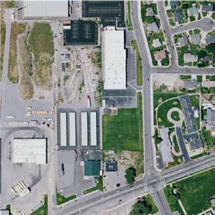
10 flow lanes over the University Parkway Single Point Urban nterchange until reaching 400 West. Phase would differ from Phase only in this segment. A station would be constructed to serve UVU near Sandhill Road and University Parkway. The only construction required in this segment would be the station. After Phase is implemented, BRT would not operate on this segment and the station would no longer be needed. From 400 West, BRT would operate on exclusive center running lanes on University Parkway through Orem s commercial district and into Provo. General purpose travel lanes and exclusive BRT lanes would be added on University Parkway from State Street to University Avenue; University Parkway currently has only two general purpose lanes in each direction in this section. After implementing the Preferred Alternative, University Parkway would have three general purpose travel lanes in each direction plus one exclusive BRT lane in each direction from 400 West to University Avenue. At University Avenue in Provo near BYU, the Preferred Alternative would transition from operating in exclusive center lanes to mixed flow. The route would then turn onto 900 East where it would run on shared lanes heading southbound and on an exclusive lane heading northbound. BRT would operate on exclusive center running lanes on 700 North, then continue on exclusive lanes on University Avenue through Provo. BRT would access the Provo ntermodal Center just south of the Union Pacific Railroad tracks via mixed flow lanes on University Avenue. BRT service would continue using mixed flow lanes south of the Provo ntermodal Center, ending at the new Southgate development and the Novell campus in Provo. Maintenance Facility. UTA is planning to expand the existing Timpanogos bus maintenance facility located on Geneva Road in Orem (see Figure ). The expansion has been planned for nearly 0 years and is included in MAGʹs Regional Transportation Plan and UTAʹs Facilities Master Plan. The planned expansion of the Timpanogos Business Unit facility will accommodate an additional 75 buses over the existing capacity of 65 buses. The need for this added maintenance capacity is based on plans for expanded local bus service in this business unit district over the next 5 years. The new expanded facility would be adequate to house the 30 additional buses that would be required for Phase of the Preferred Alternative. UTA already owns the additional property needed for this expansion, and is currently preparing a categorical exclusion to clear this bus maintenance facility expansion project environmentally. Preferred Alternative Phase Phase of the Preferred Alternative would include a new HOT interchange at 800 South and 5 to serve both vehicles and transit. The ramps off 5 would serve only HOT traffic, while the interchange overpass would include two lanes for general purpose traffic and two lanes exclusively for BRT. The interchange would be configured to accommodate center exit/entrance ramps from 5. Phase improvements would also include exclusive BRT lanes on Campus/College Drive. The Phase project in combination with the existing Phase project would be approximately miles long. BRT would operate in exclusive lanes for 7 percent of the route. For Phase, the BRT route would start at the Orem ntermodal Center and continue on 800 South and Campus/College Drive through UVU to 400 West. The Phase BRT route is the same as the Phase route from the intersection of 400 West and University Parkway eastward to Orem and Provo. 4/2/20 Page 2-0
11 800 South mprovements For Phase, 800 South would be realigned and/or widened from Geneva Road on the west side of 5 to approximately 900 West on the east side of 5 (approximately mile). The BRT exclusive lanes would tie directly into the Orem ntermodal Center via a new road at approximately 420 West. On the east side of 5, 800 South would be realigned north of its current location and tie into Campus/College Drive with a new roundabout at approximately 900 West. A short road to connect the new 800 South and the old 800 South just east of 5 is being considered (see Figure 2 2: Preferred nterchange Alternative, located at the end of the chapter). This connection would allow faster access to 200 West but would require additional land from UVU. UVU does not currently support the connection; however, it is included as a potential design option for its traffic benefits (Lochner 200a). The impacts associated with this connection are included in the overall impacts for the project (discussed in Chapter 3). The new interchange at 800 South would provide a much needed connection across 5 for autos, cyclists, pedestrians, and transit. Currently travel between the UVU campus and the Orem ntermodal Center requires using the University Parkway interchange, which is an indirect route and not friendly to pedestrians or cyclists. The 800 South interchange would make a direct connection between the UVU campus and the Orem ntermodal Center, and it would provide a safer crossing for students who live in mixed use housing on the west side of 5 to access UVU Description of HOT Lanes Only vehicles qualified to use the 5 HOT lanes would be allowed to use the 800 South interchange. Currently 5 has HOT lanes from North Salt Lake southward to Lehi (over 30 miles). UDOT plans to extend these lanes from Lehi to Spanish Fork in the future. UDOT refers to the HOT lanes as Express Lanes. The following vehicles are currently approved for HOT use: Carpoolers (vehicles carrying more than one passenger), also referred to as highoccupancy vehicles or HOV Express Pass users (with payment) Buses C plate vehicles (clean fuel designation) Motorcycles Express Pass is an electronic payment system that allows solo drivers to use the HOT lanes. UDOT monitors the number of solo drivers using the lanes to ensure there is adequate capacity for carpoolers. The electronic system charges solo drivers by using an algorithm that adjusts the price based on traffic conditions. The lanes are divided into four payment zones with overhead signs that show the price to use each zone. Readers at several locations along the Express Lanes detect in vehicle Express Passes as they travel through the zones, and driversʹ accounts are charged when they exit. BRT Service BRT service would offer higher speed, frequent, and all day bus service operation (Phase and Phase ). The proposed BRT line would be the only transit service operating along the Preferred Alternative corridor. BRT service would include the following: 4/2/20 Page 2-

12 Articulated low floor, high capacity buses specially designed with doors on both sides. An articulated bus is comprised of two rigid buses linked together by a pivoting joint in the middle, providing higher passenger capacity. Center running exclusive lanes for approximately 53 percent of the route (Phase ) Example of articulated bus: Las Vegas Max BRT bus Source: sites.google.com/site/columbusbusplan.brtcasestudie Substantial, level boarding stations with capacity to accommodate high demand at key stations such as the stadium and universities Off board fare collection (using ticket vending machines) for faster boarding Enhanced, real time transit information (next bus information) at stations Frequent service throughout the day (0 to 30 minutes) with increased service during peak periods (5 minutes) Operations between 4:30 a.m. and 2:00 a.m. Transit signal priority for BRT vehicles at most intersections. Vehicle Requirements Preliminary ridership estimates indicate that peak hour transit demand will be approximately more than 550 passengers per hour (peak hour, peak direction). Bus capacity will need to be at least 65 passengers. Therefore, 60 foot articulated specialty BRT vehicles are planned for the project. These vehicles would be adequate for Phase and Phase of the project. Since most stations are planned as center platforms, vehicles would need to provide two sided boarding, with left side and right side doors. Vehicles would be hybrid electric powered. Approximately 30 vehicles would be needed. Traffic and Signal Modifications There are approximately 38 signals on the Preferred Alternative corridor, and ntelligent Transportation Systems treatment (transit signal priority) would be implemented at most of the intersections during Phase. Specific traffic modifications include the following: A new signalized intersection would be added between State Street and 800 East in Orem. This new intersection would serve pedestrian access to the proposed station at that location, as well as a primary access for the University Mall. New pedestrian signals would be added at 600 North and 400 South on University Avenue to access center stations. All southbound and northbound left turning movements along 900 East in Provo would be prohibited except the southbound left turning movement at Heritage Drive. All eastbound and westbound left turning movements along 700 North in Provo would be prohibited, except at 700 North/University Avenue. Southbound and northbound left turning movements would be prohibited along University Avenue in Provo at 400 North, 300 North, and Center Street. A new signal would be added at 5 and 800 South for the new interchange (Phase ). 4/2/20 Page 2-2
13 Cross-Sections Typically, UDOT requires 2 foot standard travel lanes on their roads, including roads where bigger vehicles such as buses will be operating (e.g., University Parkway). However, in areas along the project corridor where there are right of way limitations, the design has been reduced to foot or 0 foot lanes (e.g., 700 North) (Lochner 200a). The locations of these cross sections are shown on Figure South nterchange (Phase ) The cross section for the new 800 South interchange is shown on Figure 2 3 on page 2 5. The improvements include two 2 foot, center running exclusive BRT lanes, 2 foot traffic separation with curb, two 2 foot general purpose traffic lanes, 2 foot left turn/median lanes to access 5 ramps, an 8 foot shoulder/bike lane, and a sidewalk. Campus/College Drive (Phase ) The improvements for Campus/College Drive between 800 South and 400 West in Orem include 2 foot, center running exclusive BRT lanes, 2 foot traffic separation with curb, reduced traffic lanes to feet, and a 4 foot shoulder/bike lane. The proposed improvements generally fit inside the existing UVU right of way; however, Campus/College Drive will need to be widened to the east. The proposed cross section for Campus/College Drive is shown on Figure 2 4 on page 2 6. University Parkway: 400 West to 800 East The improvements on University Parkway between 400 West and 800 East in Orem include 2 foot, center running exclusive BRT lanes, 2 foot traffic separation with curb, reduced traffic lanes to feet, reduced shoulders to 8 feet, and elimination of the existing median. The addition of exclusive BRT lanes will require additional right of way along the corridor. The proposed University Parkway cross section between 400 West and 800 East is shown on Figure 2 5 on page 2 7. From State Street to 800 East, the current cross section only includes two general purpose lanes in each direction. The Preferred Alternative would add a general purpose lane in each direction in this section. University Parkway: 800 East to University Avenue The improvements on University Parkway between 800 East and University Avenue include 2 foot, center running exclusive BRT lanes, 2 foot traffic separation with curb, two foot traffic lanes (in addition to reducing the four existing 2 foot traffic lanes to foot traffic lanes), 8 foot shoulders, relocation of the College Connector Trail, and barrier separation between the traffic and the trail. The proposed University Parkway cross section between 800 East and University Avenue is shown on Figure 2 6 on page East The improvements on 900 East include one 0 foot, center running exclusive lane in the northbound direction, potentially separated by 2 foot, traffic separated curb. The southbound direction uses the outside general purpose traffic lane. The proposed improvements fit inside the existing right of way, except at station locations. Additionally, the improvements maintain the four existing 0 foot traffic lanes and an 8 foot sidewalk park strip. The exclusive lane in the northbound direction would allow for a center station. The center station would provide better pedestrian accessibility than a side station on the east side of the road because the predominant pedestrian movement is from the station to BYU campus on the west. The center station is only possible with the northbound exclusive lane. The final decision on the exclusive lane will be 4/2/20 Page 2-3
14 made during final design in coordination with Provo City. The proposed 900 East cross section is shown on Figure 2 7 on page North The 700 North improvements include foot, center running exclusive BRT lanes, two foot traffic lanes, and 4 foot bike lanes. Additional right of way will be needed along certain segments of the corridor. The proposed 700 North cross section is shown on Figure 2 8 on page University Avenue: 700 North to 500 South The University Avenue improvements between 700 North and 500 South include foot, centerrunning exclusive BRT lanes, foot traffic separation with curb, two foot traffic lanes, and 4 foot shoulder or 0 foot parallel parking between 300 North and Center Street. The proposed University Avenue cross section is shown on Figure 2 9 on page /2/20 Page 2-4
15 Figure 2-3: 800 South Cross-Section (Phase ) 4/2/20 Page 2-5
 4/2/20 Page")
16 Figure 2-4: Campus/College Drive Cross-Section (Phase ) 4/2/20 Page 2-6
17 Figure 2-5: University Parkway Cross-Section: 400 West to 800 East 4/2/20 Page 2-7

18 Figure 2-6: University Parkway Cross-Section: 800 East to University Avenue 4/2/20 Page 2-8
19 Figure 2-7: 900 East Cross-Section 4/2/20 Page 2-9

20 Figure 2-8: 700 North Cross-Section 4/2/20 Page 2-20

21 Figure 2-9: University Avenue Cross-Section: 700 North to 500 South* *0-foot parallel parking is between 300 North and Center Street, not the full length of University Avenue. 4/2/20 Page 2-2

22 Stations Stations are planned mainly as single center stations, but there are a few side stations where there are no exclusive lanes. The center station design has only one platform that would serve both directions of travel. The platform would be located in the center of the roadway between the exclusive BRT lanes. Left turns would only be allowed on a green left turn movement because BRT would move with the through movements. All left turns must be signalized along the BRT route. There are several advantages of the single center station, including: less confusion for passengers as to which platform to use, cost when compared to two split far side platforms, and the platform can be located on either side of an intersection. t also necessitates buses with doors on both sides. Station locations are shown on Figure 2. Figure 2 0 to Figure 2 4 are visual renderings for proposed stations along the corridor. The renderings illustrate possible designs for stations; however, station designs will not be finalized until the next phase of the project (final design). The Phase project includes 7 stations and the Phase project includes 9 stations. The station at UVU near Sandhill Road and University Parkway would be constructed with the Phase project but would not be needed after Phase is implemented. Phase would include BRT operation in mixed flow traffic on 200 South and University Parkway from 400 West to the Orem ntermodal Center, as shown on Figure 2. Figure 2-0: Main Street Station Visualization (Orem) 4/2/20 Page 2-22
 Figure 2-2: Center")

")
23 Figure 2-: 300 North Station Rendering (Provo) Figure 2-2: Center Street Station Rendering (Provo) Figure 2-3: Perspective Rendering of University Avenue (just south of Center Street, looking north, Provo) 4/2/20 Page 2-23
 4/2/20")
24 Figure 2-4: Plan View Rendering (Provo) 4/2/20 Page 2-24

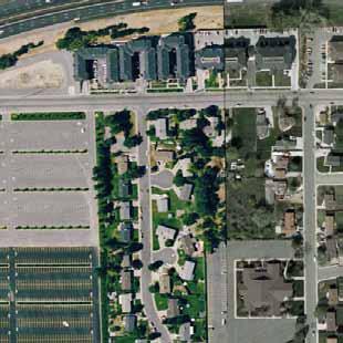
25 Provo-Orem Bus Rapid Transit 800 W Orem ntermodal Center 400 S Figure S UVU North Figure 2-4 UVU South Sandhill 400 West Exit 269 University Parkway 200 S UNVERSTY VE (US-89) ( MAN ST Utah Valley University PHASE A UNVERSTY ( 800 E 800 South 400 W Proposed New HOT nterchange University Mall Main St PKWY PHASE ( Orem Commercial District University Mall Figure 2-5 Orem N GE A EV UN V AT ST RD Figure 2-6 ( S T ER ES Lavell Edwards Stadium Y T( PK 9) Y -8 W US Fr o Provo n tr Unincorporated Utah County 2230 North 900 E u ( Figure 2-7 n C e R PUS D AM n r BYU Brigham Young University Figure 2-8 r R i ve vo East 600 North500 N Historic Downtown Center of Provo 400 South 300 North 200 N ( Figure 2-9 Center St CENTER ST 300 S TE 500 SO ST AVE (U Phase - Shared Lanes Roadway mprovements Provo ntermodal Center 80 E Provo Towne Centre Mall Phase - Exclusive Lanes 9) Phase - Exclusive Lanes (US-89) Provo ntermodal Center BRT mprovements S -8 Legend EAST Novell Phase - New General Purpose Lanes Station Location Significant Trip Generators Exit 263 University Ave Municipal Boundary Y BL VD BA Phase - Additional General Purpose Lanes STA Exit 265 Center Street 700 N UNVERSTY CENTER ST ( 00 W FREEDOM BLVD 500 W (US-89) Pro Creamery Southgate Southgate Center Stream Ditch or canal Project Location 4/2/20 Map projection is UTM2N NAD83. Base data layers from the State of Utah Automated Geographic Reference Center (AGRC) and from municipal zoning plans Kilometers Mile Figure 2- Preferred Alternative Page 2-25
26 Provo-Orem Bus Rapid Transit OPTON A OPTON A Project Location 4/2/20 Map projection is UTM2N NAD83. Base data layers from the State of Utah Automated Geographic Reference Center (AGRC) and from municipal zoning plans. Scale 350: Approximately Figure 2-2 Preferred nterchange Alternative (Phase ) Page 2-26
Executive Summary. Treasure Valley High Capacity Transit Study Priority Corridor Phase 1 Alternatives Analysis October 13, 2009.
 Treasure Valley High Capacity Transit Study Priority Corridor Phase 1 Alternatives Analysis October 13, 2009 Background As the Treasure Valley continues to grow, high-quality transportation connections
Preliminary Definition of Alternatives. 3.0 Preliminary Definition of Alternatives
 3.0 What preliminary alternatives are being evaluated? The alternatives for the East San Fernando Valley Transit Corridor project that were considered for screening include the No Build Alternative, Transportation
I-820 (East) Project Description. Fort Worth District. Reconstruct Southern I-820/SH 121 Interchange
 Project Description. Fort Worth District. Reconstruct Southern I-820/SH 121 Interchange") I-820 (East) Project Description Fort Worth District Reconstruct Southern I-820/SH 121 Interchange I-820 from approximately 2,000 feet north of Pipeline Road/Glenview Drive to approximately 3,200 feet
I-820 (East) Project Description Fort Worth District Reconstruct Southern I-820/SH 121 Interchange I-820 from approximately 2,000 feet north of Pipeline Road/Glenview Drive to approximately 3,200 feet
EUGENE-SPRINGFIELD, OREGON EAST WEST PILOT BRT LANE TRANSIT DISTRICT
 EUGENE-SPRINGFIELD, OREGON EAST WEST PILOT BRT LANE TRANSIT DISTRICT (BRIEF) Table of Contents EUGENE-SPRINGFIELD, OREGON (USA)... 1 COUNTY CONTEXT AND SYSTEM DESCRIPTION... 1 SYSTEM OVERVIEW... 1 PLANNING
METRO Orange Line BRT American Boulevard Station Options
 METRO Orange Line BRT American Boulevard Station Options Bloomington City Council Work Session November 18, 2013 Christina Morrison BRT/Small Starts Project Office Coordinating Planning and Design AMERICAN
Waco Rapid Transit Corridor (RTC) Feasibility Study
 Feasibility Study") Waco Rapid Transit Corridor (RTC) Feasibility Study Chris Evilia, Director of Waco Metropolitan Planning Organization Allen Hunter, General Manager Waco Transit System Jimi Mitchell, Project Manager AECOM
Waco Rapid Transit Corridor (RTC) Feasibility Study Chris Evilia, Director of Waco Metropolitan Planning Organization Allen Hunter, General Manager Waco Transit System Jimi Mitchell, Project Manager AECOM
6/6/2018. June 7, Item #1 CITIZENS PARTICIPATION
 June 7, 2018 Item #1 CITIZENS PARTICIPATION 1 Item #2 APPROVAL OF MINUTES Item #3 TRAC GOALS, FRAMEWORK & AGENDA REVIEW 2 COMMITTEE GOALS Learn about Southern Nevada s mobility challenges, new developments
5. OPPORTUNITIES AND NEXT STEPS
 5. OPPORTUNITIES AND NEXT STEPS When the METRO Green Line LRT begins operating in mid-2014, a strong emphasis will be placed on providing frequent connecting bus service with Green Line trains. Bus hours
STH 60 Northern Reliever Route Feasibility Study Report
 #233087 v3 STH 60 Northern Reliever Route Feasibility Study Report Washington County Public Works Committee Meeting September 28, 2016 1 STH 60 Northern Reliever Route Feasibility Study Hartford Area Development
Kendall Drive Premium Transit PD&E Study Project Kick-Off Meeting SR 94/Kendall Drive/SW 88 Street Project Development and Environment (PD&E) Study
 Study") Florida Department of Transportation District Six Kendall Drive Premium Transit PD&E Study Project Kick-Off Meeting SR 94/Kendall Drive/SW 88 Street Project Development and Environment (PD&E) Study What
Florida Department of Transportation District Six Kendall Drive Premium Transit PD&E Study Project Kick-Off Meeting SR 94/Kendall Drive/SW 88 Street Project Development and Environment (PD&E) Study What
Mississauga Bus Rapid Transit Preliminary Design Project
 Mississauga Bus Rapid Transit Preliminary Design Project PUBLIC INFORMATION CENTRE OCTOBER 2008 WELCOME The Mississauga Bus Rapid Transit (BRT) Project Thank you for attending this Public Information Centre.
IMPROVEMENT CONCEPTS
 IMPROVEMENT CONCEPTS for the South Novato Transit Hub Study Prepared by: January 11, 2010 DKS Associates With Wilbur Smith Associates IMPROVEMENT CONCEPTS Chapter 1: Introduction 1. INTRODUCTION The strategic
Rail~Volution 2005 Hal Ryan Johnson, AICP, Bus Rapid Transit Project Manager Utah Transit Authority September 7, 2005
 Rail~Volution 2005 Hal Ryan Johnson, AICP, Bus Rapid Transit Project Manager Utah Transit Authority September 7, 2005 Public Transit District Utah Transit Authority Linear Geographic Area - 130 miles by
Restoration of Historic Streetcar Services in Downtown Los Angeles
 Restoration of Historic Streetcar Services in Downtown Los Angeles Early Scoping Meeting for Alternatives Analysis (AA) May 17, 2011 Introduction Key players Local lead agency: Metro Federal lead agency:
FINAL. Sound Transit Long-Range Plan Update. Issue Paper S.1: Tacoma Link Integration with Central Link. Prepared for: Sound Transit
 Sound Transit Long-Range Plan Update Issue Paper S.1: Tacoma Link Integration with Central Link Prepared for: Sound Transit Prepared by: Quade & Douglas, Inc. FINAL March 2005 Foreword This issue paper
Executive Summary. Draft Environmental Impact Statement/Environmental Impact Report ES-1
 Executive Summary Introduction The Eastside Transit Corridor Phase 2 Project is a vital public transit infrastructure investment that would provide a transit connection to the existing Metro Gold Line
BROWARD BOULEVARD CORRIDOR TRANSIT STUDY
 BROWARD BOULEVARD CORRIDOR TRANSIT STUDY FM # 42802411201 EXECUTIVE SUMMARY July 2012 GOBROWARD Broward Boulevard Corridor Transit Study FM # 42802411201 Executive Summary Prepared For: Ms. Khalilah Ffrench,
EXECUTIVE SUMMARY. The following is an outline of the traffic analysis performed by Hales Engineering for the traffic conditions of this project.
 EXECUTIVE SUMMARY This study addresses the traffic impacts associated with the proposed Shopko redevelopment located in Sugarhouse, Utah. The Shopko redevelopment project is located between 1300 East and
SOUTHERN GATEWAY. Transportation and Trinity River Project Committee 11 May 2015
 SOUTHERN GATEWAY Transportation and Trinity River Project Committee 11 May 2015 Southern Gateway Project History Began in 2001 as a Major Investment Study [ MIS ], Schematic, and Environmental Assessment
Draft Results and Open House
 Waco Rapid Transit Corridor (RTC) Feasibility Study Draft Results and Open House Chris Evilia, Director of Waco Metropolitan Planning Organization Allen Hunter, General Manager Waco Transit System Jimi
Public Meeting. City of Chicago Department of Transportation & Department of Housing and Economic Development
 Public Meeting City of Chicago Department of Transportation & Department of Housing and Economic Development Funded by Regional Transportation Authority September 12, 2011 In partnership with Presentation
STRATEGIC PRIORITIES AND POLICY COMMITTEE MAY 5, 2016
 STRATEGIC PRIORITIES AND POLICY COMMITTEE MAY 5, 2016 Shift Rapid Transit Initiative Largest infrastructure project in the city s history. Rapid Transit initiative will transform London s public transit
Leadership NC. November 8, 2018
 v Leadership NC November 8, 2018 Planning for our region s growth The Triangle is one of the fastestgrowing regions in the nation. More than 2 million people are already part of the equation, and the
East San Fernando Valley Transit Corridor. TAC Briefing December 4, 2013
 East San Fernando Valley Transit Corridor TAC Briefing December 4, 2013 Overview Measure R Project Long Range Transportation Plan Reserves $170.1 Million 2018 Revenue Operations Date Coordination with
CEDAR AVENUE TRANSITWAY Implementation Plan Update
 CEDAR AVENUE TRANSITWAY Implementation Plan Update EECUTIVE SUMMARY DECEMBER 2015 Executive Summary In 2013, the Twin Cities metropolitan area s first bus rapid transit (BRT) line, the METRO Red Line,
Needs and Community Characteristics
 Needs and Community Characteristics Anticipate Population and Job Growth in the City Strongest density of population and jobs in Ann Arbor are within the Study Area Population expected to grow 8.4% by
4.0 TIER 2 ALTERNATIVES
 4.0 TIER 2 ALTERNATIVES The Tier 2 Alternatives represent the highest performing Tier 1 Alternatives. The purpose of the Tier 2 Screening was to identify the LPA utilizing a more robust list of evaluation
Chapter 9 Recommended Locally Preferred Alternative and Alternatives for Evaluation in Draft SEIS/SEIR
 Chapter 9 Recommended Locally Preferred Alternative and Alternatives for Evaluation in Draft SEIS/SEIR 9.0 RECOMMENDED LOCALLY PREFERRED ALTERNATIVE AND ALTERNATIVES FOR EVALUATION IN DRAFT SEIS/SEIR
Tempe Streetcar. March 2, 2016
 Tempe Streetcar March 2, 2016 Tempe Profile 40 sq. miles, highest density in state University Town, center of region Imposed growth boundaries (density increase) Mixed use growth/intensifying land use
FREQUENTLY ASKED QUESTIONS
 THE PROJECT Last updated on 9/8/16 FREQUENTLY ASKED QUESTIONS What s happening on Highway 169? The Minnesota Department of Transportation (MnDOT) is planning to rebuild and repair the infrastructure on
Green Line LRT: Beltline Recommendation Frequently Asked Questions
 Green Line LRT: Beltline Recommendation Frequently Asked Questions June 2017 Quick Facts Administration has evaluated several alignment options that would connect the Green Line in the Beltline to Victoria
Pacific Electric Right-of-Way / West Santa Ana Branch Corridor Alternatives Analysis
 Pacific Electric Right-of-Way / West Santa Ana Branch Corridor Alternatives Analysis Transit Coalition September 26, 2012 2 Study Area Pacific Electric Rightof-Way/West Santa Ana Branch (PEROW/ WSAB) extends
West Broadway Reconstruction/LRT Design. March 19, 2015
 West Broadway Reconstruction/LRT Design March 19, 2015 1 Meeting Agenda 6:05 6:30 PM Brief presentation What we heard Project overview 6:30 8:00 PM Visit Six Topic Areas Road and LRT design elements Pedestrian
Chapter 7: Travel Demand Analysis. Chapter 8. Plan Scenarios. LaSalle Community Center. Image Credit: Town of LaSalle
 Chapter 7: Travel Demand Analysis Chapter 8 Plan Scenarios LaSalle Community Center. Image Credit: Town of LaSalle 164 Chapter 8: Plan Scenarios Moving Ahead for Progress in the 21 st Century Act (MAP
TORONTO TRANSIT COMMISSION REPORT NO.
 Form Revised: February 2005 TORONTO TRANSIT COMMISSION REPORT NO. MEETING DATE: October 24, 2012 SUBJECT: DOWNTOWN RAPID TRANSIT EXPANSION STUDY (DRTES) PHASE 1 STRATEGIC PLAN ACTION ITEM RECOMMENDATIONS
US 29 Bus Rapid Transit Planning Board Briefing. February 16, 2017
 US 29 Bus Rapid Transit Planning Board Briefing February 16, 2017 Project Goals Improve the quality of transit service Improve mobility opportunities and choices Enhance quality of life Support master
Energy Technical Memorandum
 Southeast Extension Project Lincoln Station to RidgeGate Parkway Prepared for: Federal Transit Administration Prepared by: Denver Regional Transportation District May 2014 Table of Contents Page No. Chapter
Mountainland Association of Governments SPRINGVILLE-SPANISH FORK AREA TRANSPORTATION STUDY APRIL 2012
 Mountainland Association of Governments SPRINGVILLE-SPANISH FORK AREA TRANSPORTATION STUDY APRIL 2012 PLANNING FOR OUR FUTURE Planners with the Mountainland Association of Governments (MAG) have evaluated
Troost Corridor Transit Study
 Troost Corridor Transit Study May 23, 2007 Kansas City Area Transportation Authority Agenda Welcome Troost Corridor Planning Study Public participation What is MAX? Survey of Troost Riders Proposed Transit
We Want Your Input! Review the design alternatives and tell us what s important to you in the design of these areas of the approved BRT Network:
 We Want Your Input! Review the design alternatives and tell us what s important to you in the design of these areas of the approved BRT Network: Richmond North of Oxford Street Richmond Row Dundas Street
FREQUENTLY ASKED QUESTIONS
 THE PROJECT Last updated on 2/19/16 FREQUENTLY ASKED QUESTIONS What s happening on Highway 169? The Minnesota Department of Transportation (MnDOT) is planning to rebuild and repair the infrastructure on
Brigham City 1200 West Box Elder Creek Bridge - Widening Project Type Reconstruction
 Brigham City 1200 West Box Elder Creek Bridge - Widening Project Type Reconstruction 550 North to 650 North $ 1,750,000 $ 1,582,113 To widen an existing bridge on 1200 West over Box Elder Creek that will
6/11/2018. June 7, Item #1 CITIZENS PARTICIPATION
 June 7, 2018 Item #1 CITIZENS PARTICIPATION 1 Item #2 APPROVAL OF MINUTES Item #3 TRAC GOALS, FRAMEWORK & AGENDA REVIEW 2 COMMITTEE GOALS Learn about Southern Nevada s mobility challenges, new developments
The Engineering Department recommends Council receive this report for information.
 CORPORATE REPORT NO: R161 COUNCIL DATE: July 23, 2018 REGULAR COUNCIL TO: Mayor & Council DATE: July 19, 2018 FROM: General Manager, Engineering FILE: 8740-01 SUBJECT: Surrey Long-Range Rapid Transit Vision
Develop ground transportation improvements to make the Airport a multi-modal regional
 Project Overview TRANSPORTATION IMPROVEMENTS WHAT ARE THE PROJECT GOALS? Transportation transportation hub. Develop ground transportation improvements to make the Airport a multi-modal regional Land Use
I-20 EAST TRANSIT INITIATIVE Tier 1 and Tier 2 Alternatives Screening Report EXECUTIVE SUMMARY
 EXECUTIVE SUMMARY The purpose of this report is to document the results of the Tier 1 and Tier 2 Screening of alternatives for the I-20 East Transit Initiative. The two-tier screening process presented
Parking & Transportation Guide
 Parking & Transportation Guide At The UCCU Center Utah Valley University and Utah Transit Authority [UTA] have partnered in Fall of 2018 to improve access to UVU Campus and to relieve stress on transportation
Challenges in a Post-Katrina Environment East-West Corridor Project Overview February, 2007
 EAST-WEST CORRIDOR Challenges in a Post-Katrina Environment East-West Corridor Project Overview February, 2007 Presentation Agenda Project Overview / Purpose and Need Highway Component Transit Component
Snelling Bus Rapid Transit. May 13, 2013 Technical Advisory Committee Meeting #1
 Snelling Bus Rapid Transit May 13, 2013 Technical Advisory Committee Meeting #1 1 Today s meeting TAC Introductions Project Overview Arterial BRT Concept Background Snelling Corridor Plan, Funding & Schedule
Committee Report. Transportation Committee. Business Item No
 Committee Report Business Item No. 2015-280 Transportation Committee For the Metropolitan Council meeting of December 9, 2015 Subject: METRO Blue Line Extension (Bottineau Light Rail Transit) Revised Scope
US 81 Bypass of Chickasha Environmental Assessment Public Meeting
 US 81 Bypass of Chickasha Environmental Assessment Public Meeting March 14, 2013 Introductions ODOT FHWA SAIC Meeting Purpose Present need for bypass Provide responses to 10/04/11 public meeting comments
Attachment 5. High Speed Transit Planning Study REPORT SUMMARY. Prepared by: City of Edmonton Transportation Planning Branch. Stantec Consulting Ltd.
 Attachment 5 High Speed Transit Planning Study Prepared by: City of Edmonton Transportation Planning Branch Stantec Consulting Ltd. Transportation Management & Design, Inc. with Lea Consulting Ltd. [135-35130]
Public Information Workshop
 Public Information Workshop Charlotte County-Punta Gorda MPO - Meeting Rooms A and B March 29, 2018 Welcome to the Public Information Workshop for Harborview Road Project Development and Environment (PD&E)
I-10 West AA/EIS Pre-Screening and Tier 1 Analysis Results. Public Meeting. Wulf Grote, Director Project Development Rick Pilgrim, Project Manager
 I-10 West AA/EIS Pre-Screening and Tier 1 Analysis Results Public Meeting Wulf Grote, Director Project Development Rick Pilgrim, Project Manager March 4 & 5, 2008 Today s Agenda Overview of Alternatives
CITY OF LONDON STRATEGIC MULTI-YEAR BUDGET ADDITIONAL INVESTMENTS BUSINESS CASE # 6
 2016 2019 CITY OF LONDON STRATEGIC MULTI-YEAR BUDGET ADDITIONAL INVESTMENTS BUSINESS CASE # 6 STRATEGIC AREA OF FOCUS: SUB-PRIORITY: STRATEGY: INITIATIVE: INITIATIVE LEAD(S): BUILDING A SUSTAINABLE CITY
Alpine Highway to North County Boulevard Connector Study
 Alpine Highway to North County Boulevard Connector Study prepared by Avenue Consultants March 16, 2017 North County Boulevard Connector Study March 16, 2017 Table of Contents 1 Summary of Findings... 1
ANDERSON PROPERTY SITE ANALYSIS
 ANDERSON PROPERTY SITE ANALYSIS Introduction The Montgomery County Department of Transportation (MCDOT) initiated a feasibility study in the fall of 2012 to evaluate the need for transit service expansion
Community Advisory Committee. October 5, 2015
 Community Advisory Committee October 5, 2015 1 Today s Topics Hennepin County Community Works Update Project Ridership Estimates Technical Issue #4:Golden Valley Rd and Plymouth Ave Stations Technical
Note: The October 2007 version of this report has been updated in this December 2008 report to present costs in year 2007 dollars.
 Sound Transit Phase 2 South Corridor LRT Design Report: SR 99 and I-5 Alignment Scenarios (S 200 th Street to Tacoma Dome Station) Tacoma Link Extension to West Tacoma Prepared for: Sound Transit Prepared
King County Metro. Columbia Street Transit Priority Improvements Alternative Analysis. Downtown Southend Transit Study. May 2014.
 King County Metro Columbia Street Transit Priority Improvements Alternative Analysis Downtown Southend Transit Study May 2014 Parametrix Table of Contents Introduction... 1 Methodology... 1 Study Area...
CITY OF ANN ARBOR, MICHIGAN 301 E. Huron St., P.O. Box 8647 Ann Arbor, Michigan
 Date: Wednesday, June 24, 2014 Location: Ann Arbor District Library Attendees: 40 citizen attendees Ann Arbor Station Environmental Review Public Meeting Meeting Notes Meeting #2 The second public meeting
Point A Point B Point C Point D. Fulton County Board of Commissioners and Mayors Meeting December 14, 2017
 Fulton County Board of Commissioners and Mayors Meeting December 14, 2017 Master Plan Overview Phase 1 Community Vision and Existing Transit Conditions Phase 2 Scenario Development Phase 3 Transit Master
Metro Transit Update. Christina Morrison, Senior Planner Metro Transit BRT/Small Starts Project Office. John Dillery, Senior Transit Planner
 Metro Transit Update Christina Morrison, Senior Planner Metro Transit BRT/Small Starts Project Office John Dillery, Senior Transit Planner Metro Transit Service Development May 16, 2013 1 Transit Planning
Transportation Committee Revised Project Scope and Cost Estimate. November 23, 2015
 Transportation Committee Revised Project Scope and Cost Estimate November 23, 2015 1 Today s Topics Revised Project Scope Revised Cost Estimate Municipal Approval Action 2 3 Revised Project Scope Project
West Santa Ana Branch Transit Corridor. Informational Briefing Gateway Cities Service Council April 13, 2017
 West Santa Ana Branch Transit Corridor Informational Briefing Gateway Cities Service Council April 13, 2017 Project Study Area 98 square miles 20 individual cities plus unincorporated LA County 1.2 million
Welcome. Please Sign In
 Welcome South Bay Bus Rapid Transit (BRT) Draft Environmental Impact Report (DEIR) Public Meeting Please Sign In Please comment in any of the following manners: 1. Submit a comment form 2. Provide verbal
Green Line LRT: Beltline Segment Update April 19, 2017
 Green Line LRT: Beltline Segment Update April 19, 2017 Quick Facts On April 11, 2017, City Council approved Administration s recommendation for the Green Line to be underground in the Beltline from 2 Street
Northeast Corridor Alternatives Analysis. Public Involvement Round 2 Input on Alternatives for Further Study
 Northeast Corridor Alternatives Analysis Public Involvement Round 2 Input on Alternatives for Further Study Feb. 7-9, 2012 Agenda Review project background Progress summary Recommended alternatives for
Restoration of Historic Streetcar Services in Downtown Los Angeles
 Restoration of Historic Streetcar Services in Downtown Los Angeles Alternatives Analysis Community Update Meeting August 2, 2011 Introduction Key players Local lead agency: Metro Federal lead agency: Federal
GTA West Corridor Planning and EA Study Stage 1
 GTA West Corridor Planning and EA Study Stage 1 Draft Development Strategy Presentation to Peel Goods Movement Task Force April 8 2011 Study Areas 2 Unique Approach Unprecedented two-stage EA process:
KANSAS CITY STREETCAR
 KANSAS CITY STREETCAR KAREN CLAWSON MID-AMERICA REGIONAL COUNCIL KANSAS CITY STREETCAR Regional Context Alternatives Analysis Kansas City Streetcar Project KANSAS CITY REGION KANSAS CITY REGION KANSAS
CTfastrak Expansion. Stakeholder Meeting #4 Manchester Town Hall June 3, 2016
 CTfastrak Expansion Stakeholder Meeting #4 Manchester Town Hall June 3, 2016 Today s Agenda Phase I Update 2016 Service Plan Implementation Schedule & Cost Update Phase II Services Timeline Market Analysis
August 2, 2010 Public Meeting
 Public Meeting LYMMO Expansion Alternatives Analysis Study Purpose of study is to provide a fresh look at potential LYMMO expansion, following Federal Transit Administration (FTA) Alternatives Analysis
Clifton Corridor Transit Initiative. Briefing to Medlock Area Neighborhood Association (MANA) February 15, 2016
 February 15, 2016") Clifton Corridor Transit Initiative Briefing to Medlock Area Neighborhood Association (MANA) February 15, 2016 Neighborhood Concerns and Requests Provide a general overview and background of the project
Clifton Corridor Transit Initiative Briefing to Medlock Area Neighborhood Association (MANA) February 15, 2016 Neighborhood Concerns and Requests Provide a general overview and background of the project
Alternatives Analysis Findings Report
 6.0 This chapter presents estimates of the potential capital, operations and maintenance costs associated with the alternatives carried forward for detailed evaluation. The methodology used to develop
SH 249 IN GRIMES COUNTY. Open House April 3, 2014
 SH 249 IN GRIMES COUNTY Open House April 3, 2014 Meeting Agenda Purpose of Meeting Today: Review the purpose and need for the SH 249 Grimes County project Review the proposed project and alternatives Discuss
West LRT. Alignment Update and Costing Report May Calgary Transit Transportation Planning Clifton ND Lea Consultants
 West LRT Alignment Update and Costing Report 2006 May Calgary Transit Transportation Planning Clifton ND Lea Consultants West LRT Update Background The service area for West LRT is generally described
Business Advisory Committee. July 7, 2015
 Business Advisory Committee July 7, 2015 1 Today s Topics Outreach Update TI #1 and 2: Target Field Station Connection to I-94: Recommendation 85 th Station Configuration 93 rd Station Configuration DEIS
Clifton Corridor Transit Initiative. Briefing to Great Lakes Community February 11, 2016
 Clifton Corridor Transit Initiative Briefing to Great Lakes Community February 11, 2016 Neighborhood Concerns and Requests Provide a general overview and background of the project What are the different
FREQUENTLY ASKED QUESTIONS
 FREQUENTLY ASKED QUESTIONS 2018 What is the More MARTA Atlanta program? The More MARTA Atlanta program is a collaborative partnership between MARTA and the City of Atlanta to develop and implement a program
Continued coordination and facilitation with City of Austin staff on documentation of processes to permit construction activities at the site.
 Project Manager Ed Collins LJA Engineering, Inc. Transportation Planning Manager 5316 Highway 290 West Austin Public Infrastructure Group Austin, TX 78735 (512) 762-6301 cell (512) 439-4757 office CARTS
Exhibit A Sound Transit Board Resolution R Selecting the bicycle, pedestrian, and parking access improvements to be built for the Puyallup
 Exhibit A Sound Transit Board Resolution R2016-07 Selecting the bicycle, pedestrian, and parking access improvements to be built for the Puyallup Access Improvement Project. RESOLUTION NO. R2016-07 Selecting
Subarea Study. Manning Avenue (CSAH 15) Corridor Management and Safety Improvement Project. Final Version 1. Washington County.
 Corridor Management and Safety Improvement Project. Final Version 1. Washington County.") Subarea Study Manning Avenue (CSAH 15) Corridor Management and Safety Improvement Project Final Version 1 Washington County June 12, 214 SRF No. 138141 Table of Contents Introduction... 1 Forecast Methodology
Subarea Study Manning Avenue (CSAH 15) Corridor Management and Safety Improvement Project Final Version 1 Washington County June 12, 214 SRF No. 138141 Table of Contents Introduction... 1 Forecast Methodology
Table of Contents INTRODUCTION... 3 PROJECT STUDY AREA Figure 1 Vicinity Map Study Area... 4 EXISTING CONDITIONS... 5 TRAFFIC OPERATIONS...
 Crosshaven Drive Corridor Study City of Vestavia Hills, Alabama Table of Contents INTRODUCTION... 3 PROJECT STUDY AREA... 3 Figure 1 Vicinity Map Study Area... 4 EXISTING CONDITIONS... 5 TRAFFIC OPERATIONS...
PUBLIC TRANSPORTATION
 PUBLIC TRANSPORTATION PROJECT TITLE U-MED DISTRICT MULTI-MODAL IMPROVEMENTS- PHASE II Transit Vehicles and Upgrades MUNICIPALITY OF ANCHORAGE Capital Improvement Program PROJECT LIST BY DEPARTMENT Public
Help shape your community investment in Wake Transit. Fiscal Year 2019 Draft Work Plan Summary
 Help shape your community investment in Wake Transit Fiscal Year 2019 Draft Work Plan Summary Wake County, growth and transit The Triangle is one of the fastest-growing regions in the nation. Wake County
1 Downtown LRT Connector: Draft Concept
 Downtown LRT Connector: Draft Concept Plan November 2010 We re moving forward. Get involved. On June 21, 2010, City Council approved a street-level downtown LRT route, including a connector for the future
Harlem Avenue between 63 rd and 65 th
 Harlem Avenue between 63 rd and 65 th Public Meeting #2 March 13, 2018 Summit Park District Welcome to the second Public Meeting for the preliminary engineering and environmental studies of Illinois 43
Rocky Mount. Transportation Plan. Transportation Planning Division. Virginia Department of Transportation
 2020 Transportation Plan Developed by the Transportation Planning Division of the Virginia Department of Transportation in cooperation with the U.S. Department of Transportation, Federal Highway Administration
appendix 4: Parking Management Study, Phase II
 appendix 4: Parking Management Study, Phase II A4-1 A4-2 Eastlake Parking Management Study Final Phase 2 Report Future Parking Demand & Supply January 6, 2017 Submitted by Denver Corp Center III 7900 E.
Lacey Gateway Residential Phase 1
 Lacey Gateway Residential Phase Transportation Impact Study April 23, 203 Prepared for: Gateway 850 LLC 5 Lake Bellevue Drive Suite 02 Bellevue, WA 98005 Prepared by: TENW Transportation Engineering West
4 COSTS AND OPERATIONS
 4 COSTS AND OPERATIONS 4.1 INTRODUCTION This chapter summarizes the estimated capital and operations and maintenance (O&M) costs for the Modal and High-Speed Train (HST) Alternatives evaluated in this
Wentzville Parkway South Phase 2 & 2A
 Wentzville Parkway South Phase 2 & 2A Sponsor Wentzville Project No. RB18-000034 Project Type New Road TOTAL FUNDING Phase 2 Total County Sponsor Federal $10,000,000 $8,000,000 $2,000,000 $0 Phase 2A Total
VAN NESS AVENUE BUS RAPID TRANSIT
 VAN NESS AVENUE BUS RAPID TRANSIT Commission of the Environment Policy Committee May 22, 2014 Peter Gabancho Project Manager III Capital Programs & Construction SFMTA 1 Conceptual Visual Simulation Center-Running
I-405 and SR 522/NE 145th Bus Rapid Transit. Elected Leadership Groups Meeting November 30, 2018
 I-405 and SR 522/NE 145th Bus Rapid Transit Elected Leadership Groups Meeting November 30, 2018 Agenda Welcome and Introductions Public Comment BRT Connection in Bothell Common Elements: Bus base, Station
THE WAY WE MOVE LRT FOR EVERYONE
 THE WAY WE MOVE LRT FOR EVERYONE 2 LRT for Everyone LRT FOR EVERYONE Light rail is about more than transit; it s about transforming Edmonton. As the city grows, so do its transportation needs. LRT is an
Maryland Gets to Work
 I-695/Leeds Avenue Interchange Reconstruction Baltimore County Reconstruction of the I-695/Leeds Avenue interchange including replacing the I-695 Inner Loop bridges over Benson Avenue, Amtrak s Northeast
VAN NESS AVENUE BUS RAPID TRANSIT
 VAN NESS AVENUE BUS RAPID TRANSIT Peter Gabancho Project Manager III Capital Programs & Construction SFMTA Shari Tavafrashti Principal Engineer SFCTA 1 Project Purpose and Need Improve transit reliability,
Draft Results and Recommendations
 Waco Rapid Transit Corridor (RTC) Feasibility Study Draft Results and Recommendations Chris Evilia, Director of Waco Metropolitan Planning Organization Allen Hunter, General Manager Waco Transit System
2 EXISTING ROUTE STRUCTURE AND SERVICE LEVELS
 2 EXISTING ROUTE STRUCTURE AND SERVICE LEVELS In the Study Area, as in most of the Metro Transit network, there are two distinct route structures. The base service structure operates all day and the peak