Legacy Development Travel Demand Management Plan
|
|
|
- Penelope Hawkins
- 5 years ago
- Views:
Transcription

1 Travel Demand Management Plan Minneapolis, MN Prepared By: Stephen Smith Alliant Engineering, Inc. 233 Park Avenue South, Suite 300 Minneapolis, MN Prepared For: Riverdale Ventures, LLC Main Street NW, Suite 300 Coon Rapids, MN Final Report
2 Table of Contents List of Figures... i List of Tables... i 1.0 Introduction Site and Development Characteristics Proposed Parking Characteristics Pedestrian, Bicycle, And Transit Characteristics City Of Minneapolis Transportation Goals Goals of the Parking Impact Analysis... 9 Parking Demand Calculations Transportation Impact Analysis Site Generated Traffic Traffic Operations Analysis List of Figures Figure 1. Project Location... 5 Figure 2. Proposed Site Plan... 6 Figure 3. Bicycle Map... 7 Figure 4. Transit Map... 8 Figure 5. Existing Geometry Figure No-Build Peak Hour Volumes Figure 7. Generated Trip Distribution Figure Build Peak Hour Volumes List of Tables Table 1. Proposed Land se Characteristics Summary... 2 Table 2. Proposed Mode Split Goals... 4 Table 3. Proposed Parking Characteristics... 9 Table 4. Maximum Parking Stalls Required Chapter Table 5. Minimum Parking Stalls Required Parking Generation Method Table 6. Minimum Required Bicycle Parking Spaces Table 7. Trip Generation Table 8. No-Build Operational Analysis Results Table 9. Build Operational Analysis Results Alliant Engineering, Inc. i
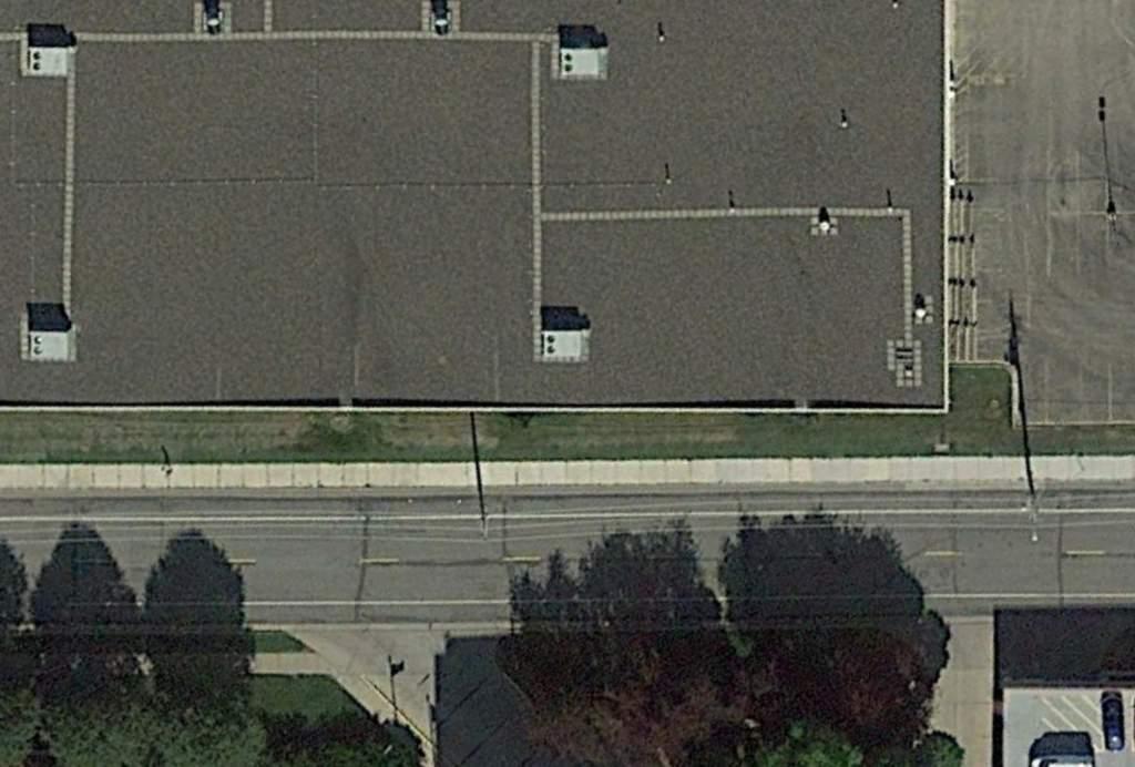
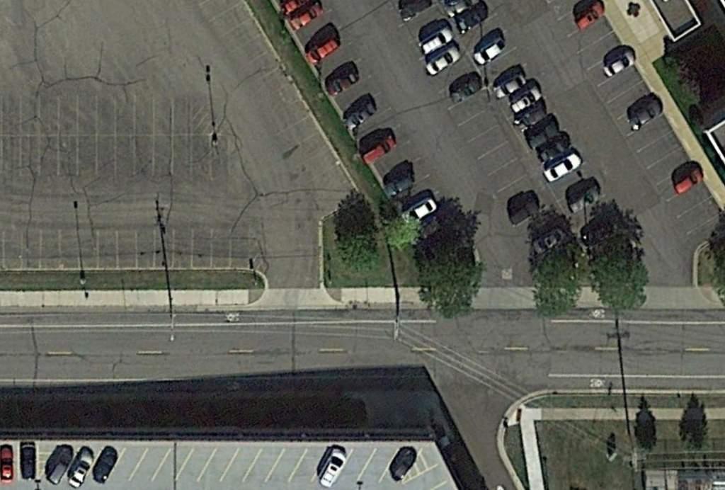
3 The Legacy development project (i.e. proposed project) is a residential condominium development located in the Downtown East Neighborhood of Minneapolis. The project is scheduled to be completed by late pon full completion, the development will consist of 374 condominium units and three levels of enclosed parking with a total of 704 parking stalls. The site is 186,121 s.f. in size and the building will be 748,000 s.f. resulting in a 17-story luxury condominium complex divided in three sections: 17 stories, 8 stories, and 14 stories. There will be amenity space within the building for the residents including a pet grooming area, community rooms, exercise space, a pool and roof terrace areas. The site also includes a dog run enclosure and a playground. The residents and guests will be provided with 704 total parking stalls. Of the 704 parking stalls, 18 parking stalls will be provided for guests and 686 will be for the residents. As part of the proposed project, the City of Minneapolis has required a Travel Demand Management (TDM) Plan. The goal of the TDM plan is to accomplish the following: Document the existing and proposed conditions with respect to transit, parking, bicycle and pedestrian facilities; Document the parking impacts with the proposed project; Identify any loading operations issues for the different uses of the site; Identify any traffic operations issues; and Develop and implement measures to encourage non-single occupancy vehicle modes of transportation. 1.1 Site and Development Characteristics Site Location The proposed project site is located in the Downtown East Neighborhood, immediately adjacent to the Minneapolis downtown Central Business District (CBD). The proposed development is located north of South 2 nd Street and south of West River Parkway, between 12 th Avenue South and 13 th Avenue South. Figure 1 illustrates the project location. Existing Site Characteristics The site of the proposed project is on the corner of South 2nd Street and 13 th Avenue South. Currently, the Cenveo building occupies the site. The existing building has a surface parking lot that holds 148 parking stalls. The property is currently zoned as I1 (Light Industrial District) with DH (Downtown Height Overlay District), DP (Downtown Parking Overlay District), and IL (Industrial Living Overlay District) overlays. The zoning will need to be changed to C3A, Community Activity Center District, to accommodate the proposed land development purpose. Proposed Site Characteristics As submitted for site plan approval, the enclosed parking area will be served by two main driveways along 13 th Avenue South. A one-way drive-lane serving the front door drop-off/pickup area is proposed on South 2 nd Street. The proposed site plan is illustrated in Figure 2. Alliant Engineering, Inc. 1
4 The proposed development will add 374 residential dwellings to the area. Off-Street parking stalls for the residential units will be provided at a 1.83 ratio (off-street parking stalls per dwelling unit) resulting in 686 designated residential parking stalls. It should be noted that this parking ratio does not include the 18 designated guest parking spaces. This site is located in the DP Downtown Parking Overlay District where the maximum parking ratio is 1.7 stalls per unit. The developer is seeking a variance to allow a 1.83 parking ratio. Any changes to these parking considerations will require City approval and changes to this TDM plan. Additionally, one bike space per unit will be provided within the resident parking areas and four bike spaces for the guest parking area. Table 1 summarizes the proposed land use characteristics. Table 1. Proposed Land se Characteristics Summary Estimated Schedule Project Completion: 2017 Land se Changes Change Zoning from I1 to C3A. 12 Power lines will be impacted. Construct a new 374-unit residential building Parking Changes Remove 148 parking stalls within the existing surface lot. Add a 704 space enclosed parking garage. 1.2 Proposed Parking Characteristics As described previously, the enclosed parking area will be served by two main driveways along 13 th Avenue South. A one-way drive-lane serving the front door drop-off/pick-up area is proposed on South 2 nd Street. The proposed project intends to provide adequate parking for its residents. However, the site location being adjacent to the CBD enables residents and guests to access the project site and nearby commercial districts by other modes. Refer to Section 1.3, below, and Section 2.0 (Parking Impact Analysis) for further discussion. 1.3 Pedestrian, Bicycle, And Transit Characteristics The proposed development is located six blocks from the Minneapolis CBD. The location proximity to a major destination provides residents with easy access to other modes of transportation, such as walking, bicycling, and transit. The project site is approximately eight blocks from the nearest skyway entrance which is located in the Gateway Ramp, on South 3 rd Street between 4 th Avenue South and 5 th Avenue South. The proposed development is located adjacent to designated bike routes on South 2 nd Street and 11 th Avenue South, which provide access to the Stone Arch Bridge, Mill Ruins Trails, LRT trail and the Park Avenue and Portland Avenue Bikeways. These bikeways provide convenient access to all downtown and Mississippi River bicycle trails. Figure 3 illustrates designated bicycle trails within the Minneapolis downtown area. However, in an urban downtown setting, bicycles are allowed on all city streets, except where otherwise posted. The proposed project will provide 374 bike spaces around the perimeter of the parking areas. The proposed development is also ideally suited for transit access. Currently, two bus routes maintain frequent service along Washington Avenue Metro Transit Route 7 and Metro Transit Route 22. These two bus routes connect the project site to the Minneapolis CBD, South Alliant Engineering, Inc. 2
5 Minneapolis, North Minneapolis, and the near North Suburbs. At each of these destinations numerous bus routes are available for transfer. Numerous express and local service bus routes can be accessed at the Gateway Transit Center, located in the Gateway Ramp, seven blocks west of the proposed project site. Additional bus routes accessed via the Gateway Transit Center include: 133, 135, 146, 156, 460, 464, 465, 467, 470, 472, 476, 477, 478, 479, 490, 491, 554, 568, 587, 665, 670, 677, 684, 698, 755, 756, 758 and 764. In addition to bus service, the METRO Blue line, with destinations between Target Field, Nicollet Mall, Minneapolis CBD, Mall of America, and the International Airport can be accessed at the S Bank Station (former Downtown East/Metrodome Station), which is located at the Chicago Avenue/4 th Street intersection, five blocks away. With the addition of the METRO Green line, downtown Minneapolis and downtown St. Paul via Washington Avenue and niversity Avenue can be accessed by residents. The METRO Green line can also be accessed at the S Bank Station (former Downtown East/Metrodome Station). Figure 4 illustrates the downtown transit system. There is additional opportunity around the area to use Peer-to-peer Car Share or Round-Trip Car Share. The City of Minneapolis offers may different car sharing opportunities in the Downtown CBD area. A point-point floating car, car2go, located near Park Avenue and South 5 th Street is available for use. Vehicles are generally parked on-street and each vehicle displays a permit sticker identifying it as a Minneapolis Car Sharing Program participant s vehicle. A round-trip car is available through HORCAR, located near South 3 rd Street and 2 nd Avenue South, cars will be parked at reserved on-street spaces for exclusive use of HORCAR vehicles. 1.4 City Of Minneapolis Transportation Goals The following policies on transportation are included in Chapter 2 (Transportation) of the Minneapolis Plan for Sustainable Growth, adopted by the Minneapolis City Council, October 2, 2009 ( 2.1 Encourage growth and reinvestment by sustaining the development of a multi-modal transportation system. 2.2 Support successful streets and communities by balancing the needs of all modes of transportation with land use policy. 2.3 Encourage walking throughout the city by ensuring that routes are safe, comfortable, pleasant, and accessible. 2.4 Make transit a more attractive option for both new and existing riders. 2.5 Ensure that bicycling throughout the city is safe, comfortable and pleasant. 2.6 Manage the role and impact of automobiles in a multi-modal transportation system. 2.7 Ensure that freight movement and facilities throughout the city meet the needs of the local and regional economy while remaining sensitive to impacts on surrounding land uses. 2.8 Balance the demand for parking with objectives for improving the environment for transit, walking and bicycling, while supporting the city s business community. Alliant Engineering, Inc. 3
6 2.9 Promote reliable funding and pricing strategies to manage transportation demand and improve alternative modes Support the development of a multi-modal Downtown transportation system that encourages an increasingly dense and vibrant regional center Minneapolis recognizes the economic value of Minneapolis-St. Paul International Airport and encourages its healthy competition to reach global markets in an environmentally responsible manner. Table 2 presents the proposed mode split goals for the site based on similar development s mode splits in the area. The mode-split percentages listed in Table 2 serve as a benchmark to make the management of the developments cognizant of transportation management issues that accompany a diverse and growing neighborhood. Therefore, the purpose of the TDM plan is to identify workable strategies that the Developer can implement in support of the City of Minneapolis transportation goals. Table 2. Proposed Mode Split Goals Mode Goal Single Occupant Vehicle (SOV) 30% Transit (Bus & LRT) 20% Carpool and Drop-off 15% Pedestrian/Bicycle/Other 35% 1.5 Goals of the ltimately, the responsibility to use other forms of transportation lies with the individuals choosing to visit, work or live within the proposed development. However, the Developer understands and acknowledges the overall transportation goals of the City. Therefore, the goal of this TDM plan is to support the City of Minneapolis in achieving its transportation goals for Minneapolis and to work towards or improve on the mode split targets for site-generated trips. This TDM plan identifies actions to be taken by the proposed management in order to manage site-generated traffic and minimize peak period trip generation. The addition of a condominium complex near major transit lines captures many people who would have otherwise commuted via motorized vehicle. Nevertheless, the proposed development makes available to its staff and residents information on a variety of programs and services that include: bus service, park-andride lots, and bicycle and car sharing facility information. The TDM plan will be presented in Section 4.0. Alliant Engineering, Inc. 4
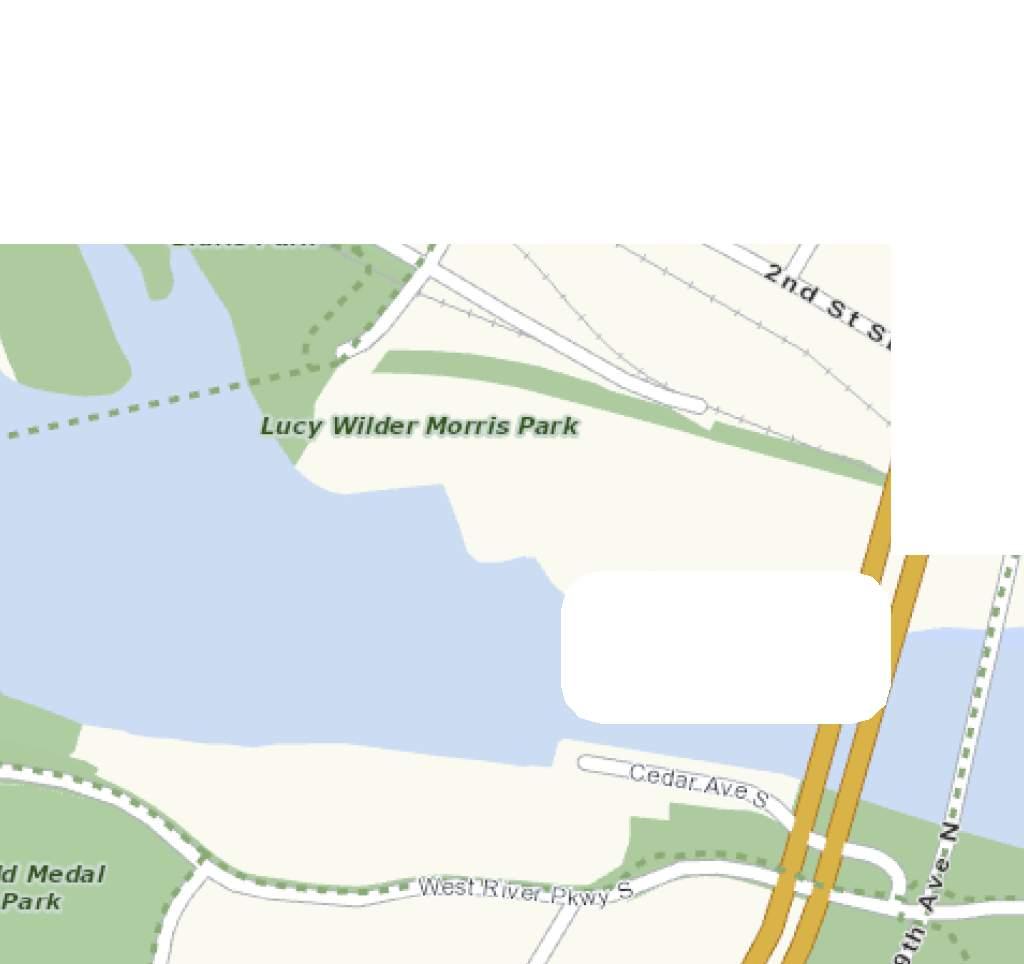
7 1500 SCALE IN FEET BNSF INTERSTATE 35W BNSF INTERSTATE 394 HENNEPIN AVE NICOLLET M ALL 2ND AVE S 4TH AVE S 2ND ST S W ASHINGTON AVE S PORTLAND AVE S CHICAGO AVE S 10TH AVE S 11TH AVE S 12TH AVE S Ry. PROJECT LOCATION INTERSTATE 94 L.R.T. INTERSTATE 94 LEGACY DEVELOPMENT TDMP ALLIANT E N G I N E E R I N G Figure 1 Project Location


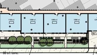
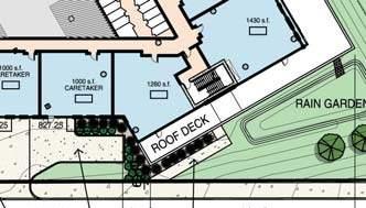
8 SOTH 2ND STREET 13TH AVENE SOTH ACCESS 1 & 2 ï» â ACCESS TO GEST AND TENANT PA LEGACY DEVELOPMENT TDMP ALLIANT E N G I N E E R I N G Figure 2 Site Plan


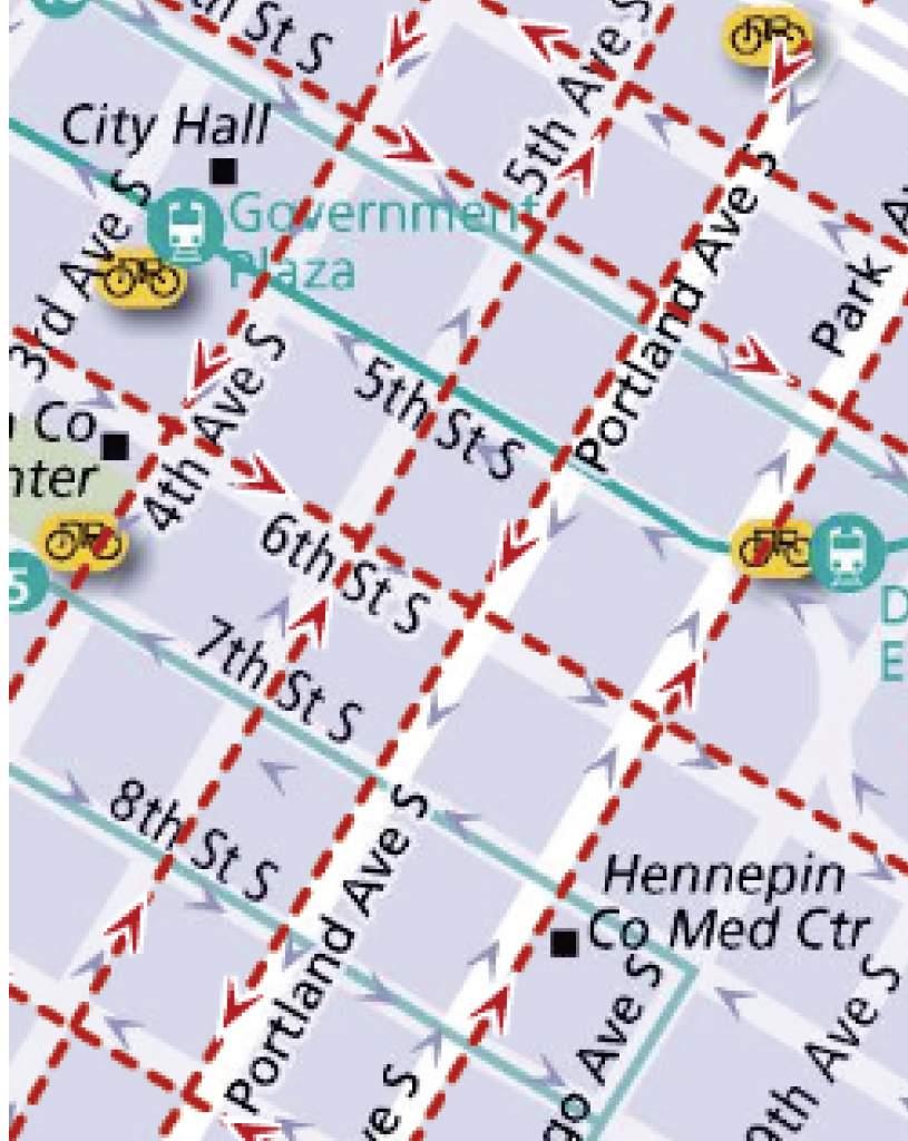
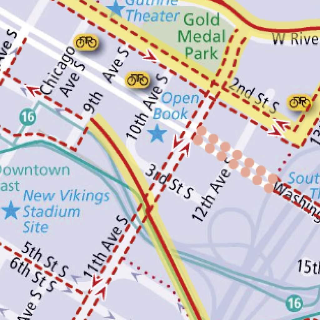
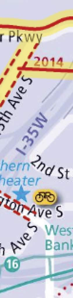
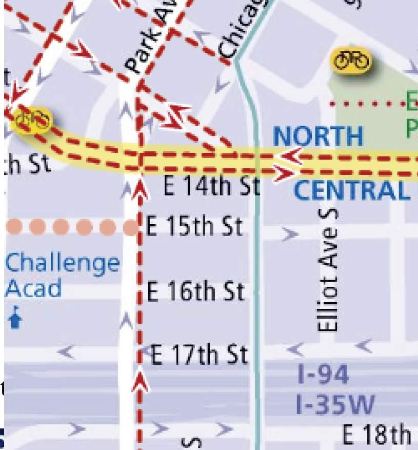
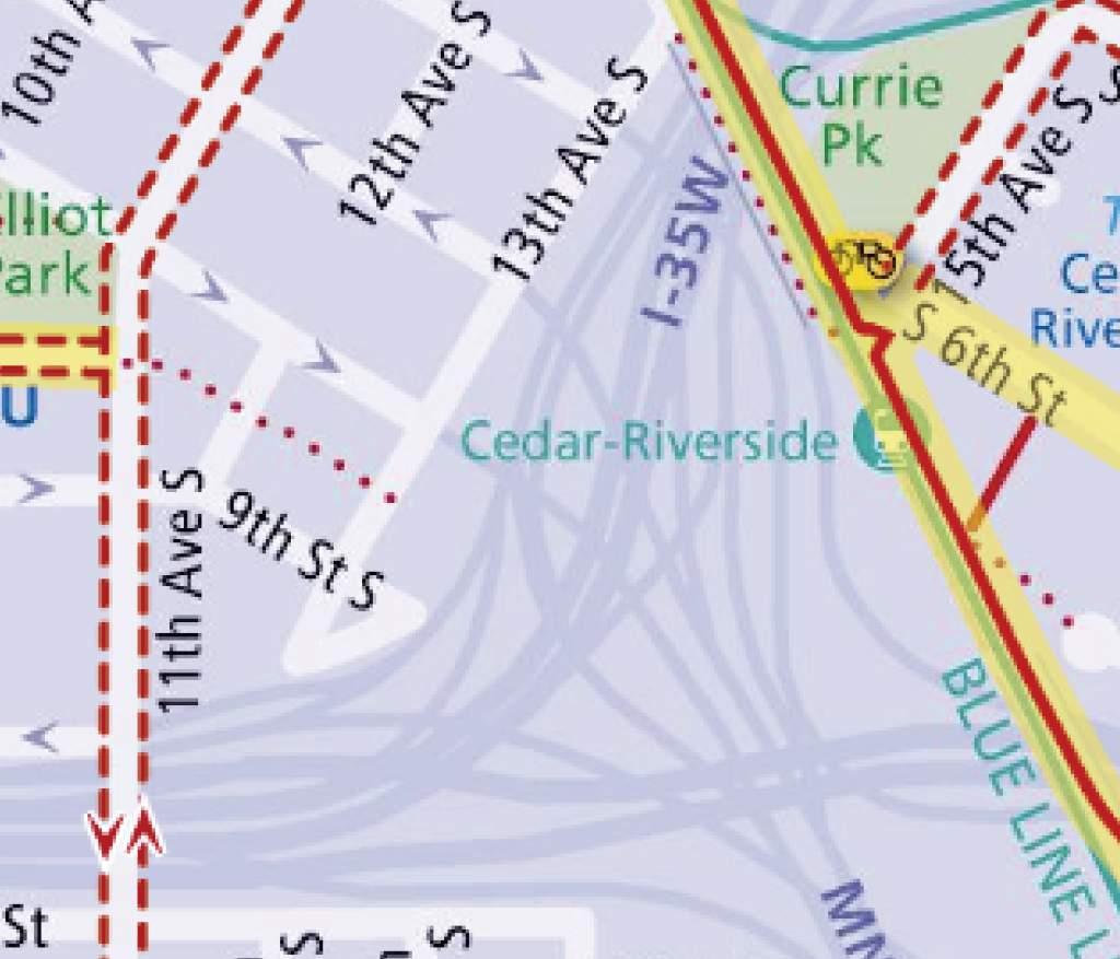

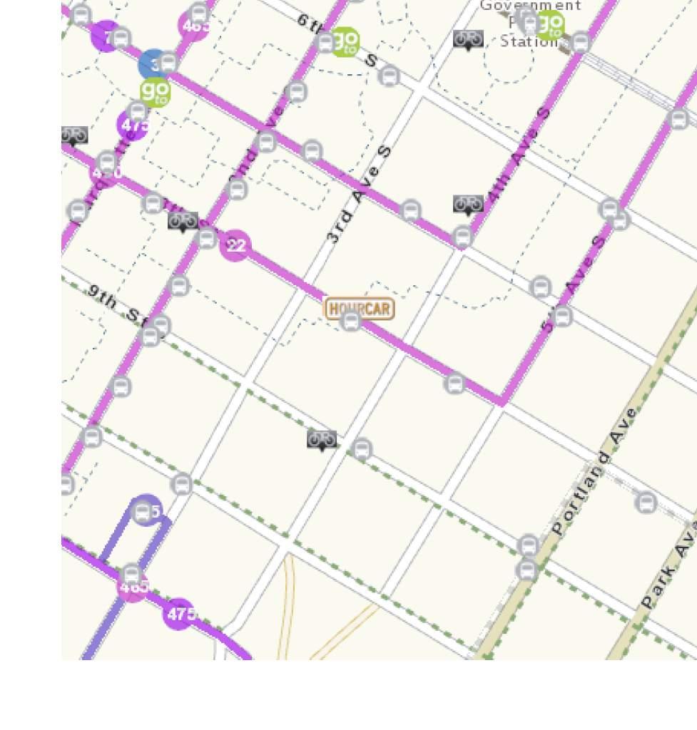
9 PROJECT LOCATION LEGACY DEVELOPMENT TDMP ALLIANT E N G I N E E R I N G Figure 3 Bicycle Facilities


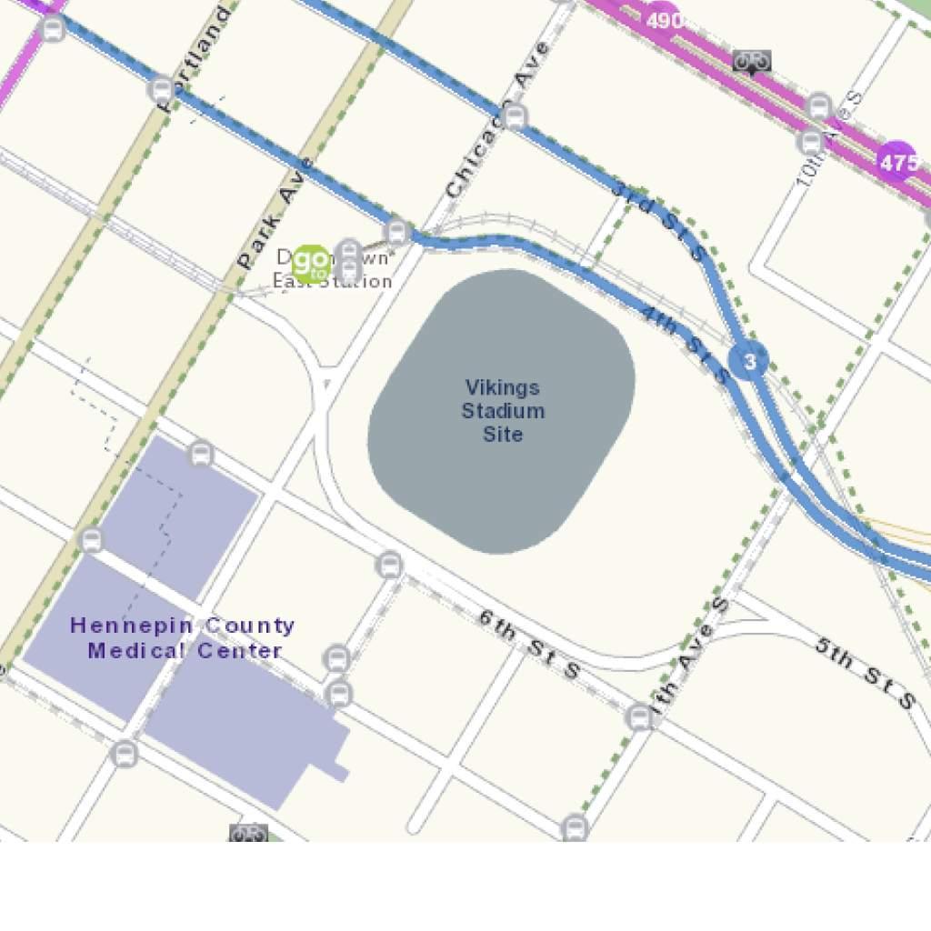
10 PROJECT LOCATION BS ROTES 7,22,465,475, and 490 LEGACY DEVELOPMENT TDMP ALLIANT E N G I N E E R I N G Figure 4 Transit Routes

11 As documented previously, the existing vacant site consists of 148 parking stalls. With the proposed project, the site will remove all 148 parking stalls and will construct a 704-space enclosed parking garage for use by residents and guests. The parking characteristics of the proposed site consist mainly of off-street parking, but visitors may occasionally park on-street if the allocated guest parking stalls in the above ground lot are full. The existing on-street parking services the surrounding land uses by providing metered short duration parking for visitors and patrons of the area s commercial uses. Off-street parking provides for long duration parking associated with residential owners and guests. This section summarizes the parking impact analysis for the proposed development. Table 3 summarizes the proposed parking details for the site. Table 3. Proposed Parking Characteristics se Size # of Spaces Location Access Condominium 374 nits 704 Enclosed Parking Garage Total 374 nits 704 Entering and Exiting: 13th Avenue South Residential Parking An access controlled enclosed parking garage is proposed for the residents and guests. The garage is proposed to be three levels consisting of a total of 704 stalls. Access to the parking garage will be secure and controlled with an electronic key. There will also be a call device at the garage door for visitors to call a resident and get buzzed in. Parking Demand Calculations The parking demand expected with the Project was estimated based on two methodologies the City of Minneapolis Zoning Code and the Institute of Transportation Engineers Parking Generation Manual. Method 1 Minneapolis Zoning Code The first method involves the application of the computation for off-street parking found in Article III of Chapter 541 of the Minneapolis Zoning Code. The Minneapolis Zoning Code states that a minimum of one off-street parking stall and maximum of 1.7 off-street parking stalls (based on DP Downtown Parking Overlay District requirements) per residential unit is required. In accordance with the Minneapolis Zoning Code Section , the required number of parking stalls may be reduced by 50 percent due to the proposed sites proximity to the S Bank Station. Table 4 documents the parking provided verses the minimum and maximum parking required by the Minneapolis Zoning Code. As shown in Table 4, the proposed project will exceed the maximum number of allowed parking spaces for residential development in the DP Downtown Parking Overlay District. The developer is requesting a variance to allow for the additional parking stalls. Alliant Engineering, Inc. 9
12 Table 4. Maximum Parking Stalls Required Chapter 541 Rate Required Spaces Parking se Dwellings Reductions Min Max 1 Min. Min. Total with Max Reductions Proposed Land ses Parking Residential reduction of 1 space/dwelling unit 1.7 spaces/dwelling unit % Guest 1 space/50 dwelling units 8 Grand Total Max residential parking ratio for the DP Downtown Parking Overlay District. Method 2 Parking Generation Computation The second method involves the application of the parking generation rate from the Institute of Transportation Engineers (ITE) Parking Generation Manual, Fourth Edition. This resource documents numerical trends in parking demand for a variety of land uses based upon the day of the week, time of day, and size of the development, and whether the site is urban or suburban. Furthermore, these rates are developed upon research of similar locations and experiences of transportation engineering professionals and would be considered a more accurate depiction of the actual parking demand expected with the proposed project. Based on the Parking Generation Manual, a parking demand of 1.4 stalls per dwelling unit 1 is expected for a development located in an urban area. Table 5 illustrates the parking supply and demand for the development. Table 5. Minimum Parking Stalls Required Parking Generation Method Required Provided Parking se Dwellings Rate Spaces Spaces Residential spaces/dwelling unit Bicycle Parking The City of Minneapolis requires a minimum of 1 bicycle parking space for every 2 dwelling units. Riverdale Ventures will provide one bike space per unit or 374 spaces within the resident parking areas and four bike spaces for the guest parking area. Table 6 details the minimum parking requirements for the proposed land use. 1 ITE Parking Generation Manual, 4 th Edition, Land se Code 230 Alliant Engineering, Inc. 10
13 Table 6. Minimum Required Bicycle Parking Spaces Parking se nits/sf Rate Required Spaces Residential space/dwelling unit 187 Parking Conclusions The proposed project will provide adequate parking. The developer is requesting a variance to increase the maximum amount of parking from 636 spaces to 704 spaces, which results in a 1.83 parking ratio. In addition to off-street parking, ample metered on-street parking is available within a one-block radius of the site. The Minneapolis bicycle parking requirement of 187 spaces is satisfied with the 374 proposed bike spaces. Alliant Engineering, Inc. 11
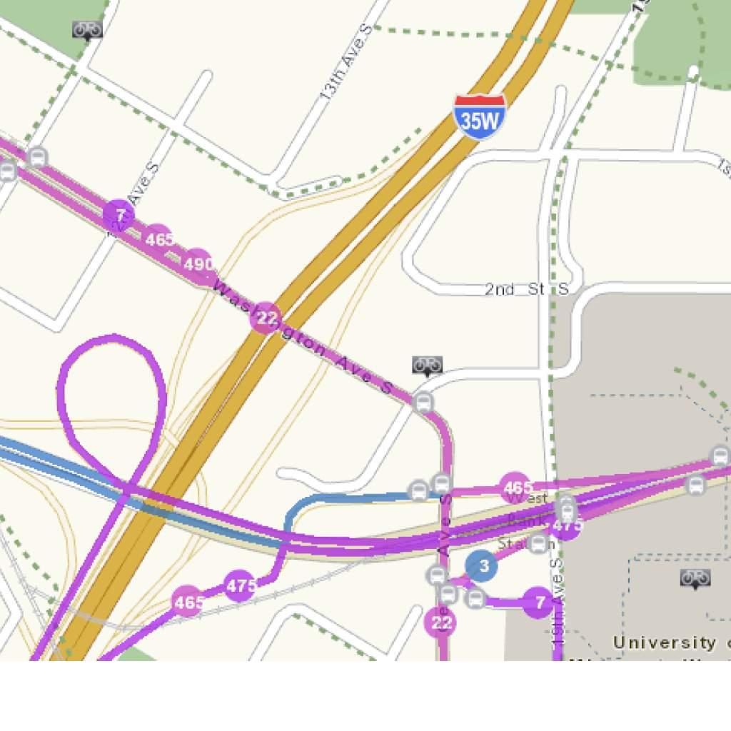
14 This section of the TDM plan describes impacts to the transportation system resulting from the development of this property. The purpose of the traffic analysis is to evaluate the impact of traffic generated by the proposed project on the operations and safety of the adjacent roadway network and immediate site/parking access. The study will detail changes in roadway conditions in the study area due to the development. Recommendations regarding geometric and/or traffic control needs to accommodate additional background traffic, site-generated traffic, and improve safety are included, as required. The following intersections were evaluated: Washington Avenue and 11 th Avenue South 11 th Avenue South and West River Parkway Washington Avenue and 12 th Avenue South AM and PM peak hour turning movement counts were collected by Alliant Engineering on Tuesday, February 9, 2016 for the three intersections mentioned above. The AM peak hour is from 8:00 a.m. to 9:00 a.m. The PM Peak hour is from 5:00 p.m. to 6:00 p.m. Peak-hour turning movement counts were taken to represent the 2017 No-Build scenario, or the existing traffic system. The existing No-Build peak-hour volumes are shown in Figure Site Generated Traffic To establish the 2017 Build traffic volumes, the number of trips generated by the proposed project were estimated. Trip generation rates for the proposed development were obtained from the Trip Generation Manual 2. Table 7 presents the new external AM peak hour, PM peak hour and daily vehicle trips expected. Table 7. Trip Generation Land se (ITE Code) AM Peak Hour Trips PM Peak Hour Trips nits Size Trips Trips Total Trips Trips Rate Rate In Out Trips In Out Proposed Land se - Legacy Condominiums Daily Trips Total Rate Trips Residential Condominium / Townhouse nits ,173 (230) Net Total Trips , Per the Institute of Transportation Engineers (ITE) Trip Generation Manual, 9th Edition. Based on the proposed land uses for the project, 166 new AM peak hour, 196 new PM peak hour, and 2,173 new total daily trips are expected in addition to existing trips. It should be noted that the estimated number of external trips generated is expected to be conservative. The actual number of trips should be less based upon the proximity of the proposed project in relation to the CBD and achievement of the anticipated modal split goals. In addition, the existing trips from existing land uses were not subtracted out of the network. These new vehicle trips were distributed throughout the system and evaluated in the traffic operations analysis using system Total Trips 2 Trip Generation Manual, Institute of Transportation Engineers (ITE), 9 th Edition Alliant Engineering, Inc. 12
15 generation assumptions, as shown in Figure 7. The distributed generated trip volumes, in addition to existing volume data, are depicted in the Build scenario in Figure Traffic Operations Analysis A traffic operations analysis was performed for the two volume scenarios (2017 No-Build and 2017 Build conditions) utilizing the existing street network. The analysis was completed using Synchro 8.0 and Simtraffic 8.0 and assumed existing traffic signal timing. The traffic operations analysis followed methods set forth in the Highway Capacity Manual (HCM). The Level of Service (LOS) was documented for the key intersections. LOS is a measure used to quantify the traffic operations at an intersection or roadway section. LOS ranges from A to F, with A being non-congested, free-flowing conditions, and F being very congested and near capacity conditions. An LOS of D or E is generally considered the indicator of congestion in an urban area. The results of the No-Build and Build traffic operations analysis are shown below in Tables 8 and 9. Table 8. No-Build Operational Analysis Results Node Control Intersection Table 9. Build Operational Analysis Results AM Peak Int. Delay (s/v) LOS PM Peak Int. Delay (s/v) LOS 701 Signal Washington Ave and 11th Street 22.7 C 25.3 C 702 Thru-Stop 11th Street and West River Parkway 2.3 A 3.0 A 703 Thru-Stop Washington Ave and 12th Street 1.8 A 2.0 A 1. AM Peak and PM Peak delays computed using 5 random seeds in SimTraffic Node Control Intersection AM Peak Int. Delay (s/v) LOS PM Peak Int. Delay (s/v) LOS 701 Signal Washington Ave and 11th Street 24.4 C 27.4 C 702 Thru-Stop 11th Street and West River Parkway 2.3 A 3.0 A 703 Thru-Stop Washington Ave and 12th Street 1.9 A 2.0 A 1. AM Peak and PM Peak delays computed using 5 random seeds in SimTraffic For both No-Build and Build conditions, all intersections and access points operate acceptably with an LOS of C or better during the AM and PM Peak periods. The addition of the sitegenerated traffic had a negligible effect on the operations of the traffic system. Based on the analysis there are no extra traffic control or geometric improvements expected to be necessary. Alliant Engineering, Inc. 13

16 100' 100' 100' 100' 100 WESTRV IE RPKW Y SCALE IN FEET PROJECT LOCATION 13TH AVENE S 2ND STREET S 100' 100' WASHINGTON AVENE S 11TH AVENE S 12TH AVENE S LEGEND TRAFFIC SIGNAL TRAVEL LANES NSIGNALIZED INTERSECTION XX' TRN BAY LENGTH LEGACY DEVELOPMENT TDMP ALLIANT E N G I N E E R I N G Figure 5 Existing Geometrics
17 23/ 1 60/ /288 45/ / /145 78/162 10/15 128/ /68 128/ /846 97/132 18/29 71/151 27/15 722/ / WESTRV IE RPKW Y SCALE IN FEET 2ND STREET S PROJECT LOCATION 13TH AVENE S 7/10 174/ / /32 3/0 937/ /5 15/88 WASHINGTON AVENE S 11TH AVENE S 12TH AVENE S LEGEND TRAFFIC SIGNAL TRAVEL LANES NSIGNALIZED INTERSECTION XX/XX AM VOLMES /PM VOLMES LEGACY DEVELOPMENT TDMP ALLIANT E N G I N E E R I N G Figure No-Build Peak Hour Volumes


18 100 2% WESTRV IE RPKW Y 2% 13TH AVENE S SCALE IN FEET PROJECT LOCATION 2ND STREET S 40% 46% WASHINGTON AVENE S 11TH AVENE S 5% 12TH AVENE S LEGEND TRAFFIC SIGNAL NSIGNALIZED INTERSECTION X% PERCENT OF TRIPS GENERATED AND DIRECTION LEGACY DEVELOPMENT TDMP ALLIANT E N G I N E E R I N G Figure 7 Generated Trip Distribution


19 55/27 68/ /320 45/ / /145 78/162 10/19 128/ /72 132/ /858 97/132 22/29 75/151 39/59 722/ / WESTRV IE RPKW Y SCALE IN FEET 2ND STREET S PROJECT LOCATION 13TH AVENE S 23/22 182/ / /32 7/8 997/ /5 15/88 WASHINGTON AVENE S 11TH AVENE S 12TH AVENE S LEGEND TRAFFIC SIGNAL NSIGNALIZED INTERSECTION TRAVEL LANES XX/XX AM VOLMES /PM VOLMES LEGACY DEVELOPMENT TDMP ALLIANT E N G I N E E R I N G Figure Build Peak Hour Volumes
20 The following TDM plan for the proposed project identifies the program, responsibilities, and detailed implementation of the TDM plan by Riverdale Ventures, LLC. or their successor for the parking and transportation issues summarized above. Riverdale Ventures, LLC. recognizes the desire for safe and convenient travel alternatives to single-occupant vehicle commuting that reflects the Twin Cities region s economic, environmental, and social needs. Riverdale Ventures, LLC. understands and supports the objective to minimize travel demand, especially during the morning and afternoon peak hours. Riverdale Ventures, LLC. or their successors, the building managers, or the Homeowners Association agree to the following measures to help meet the City of Minneapolis Transportation Goals: 1. Level of Participation with Transportation Management Organization (TMO) Resident Transportation Coordinator: Riverdale Ventures, LLC. or their successors will designate a Transportation Coordinator to work with residents on the implementation of this TDM plan. The Transportation Coordinator will work closely with the Metro Transit TDM Consultant, Suzan Forsberg, to disseminate commuting information and materials to residents and visitors; participate in regional training or informational sessions about TDM programs; be available to meet once a year with the Transportation Coordinator to review available regional programs and services; and monitor progress on fulfilling the TDM commitments. Downtown Minneapolis TMO: The Downtown TMO is a private partnership of the City of Minneapolis and downtown business community. The Downtown TMO website ( is an excellent resource for Developers that encourage commuting. 2. Communication and Information for Residents Dissemination of information: Riverdale Ventures, LLC. or their successors will disseminate information on transit and biking alternatives to its residents. Bus route maps and schedules will be available in the Business Office. Information will include transit schedules, local bicycle commuting facilities and maps, car-pooling programs, flex-car programs and other similar programs. Commuter information program: With assistance from the Downtown Minneapolis TMO, Metro Transit, and Metro Commuter Services, Riverdale Ventures, LLC. or their successors will develop a commuter information program to familiarize residents with the variety of available transportation resources. Move-in packages: Riverdale Ventures, LLC. or their successors will create and implement a move-in transportation alternatives package for new resident. The movein package will provide each resident with all information and resources available to inform and encourage alternative modes of transportation. Alliant Engineering, Inc. 18
21 Transit: Riverdale Ventures, LLC. or their successors will include a real time transit information screen in the lobby for guests. 3. Encourage Car and Vanpooling Riverdale Ventures, LLC. or their successor will actively promote car and vanpooling as alternative means of commuting among the residents and visitors, primarily through information dissemination. 4. Support and Promote Bicycling and Walking as Alternatives Facilities Riverdale Ventures, LLC. or their successors will actively promote bicycling and walking as alternative means of commuting among residents and visitors of the site, primarily through information dissemination and the provision of bicycle storage facilities. 5. Off-peak Truck and Service Scheduling Off-peak scheduling: Riverdale Ventures, LLC. or their successors will encourage truck and service vehicles, not including small package deliveries, to access the site outside of the weekday AM and PM peak traffic periods. The proposed project will accommodate the loading/unloading of deliveries, service vehicles and garbage trucks on site. No on-street space will be allocated for delivery and service vehicles. 6. Monitoring of Travel Behavior With the assistance of the Downtown Minneapolis TMO, Riverdale Ventures, LLC or their successors commit to the following: Original survey: Riverdale Ventures, LLC or their successors will develop a methodology for surveying the travel behavior of a sample of its residents, once 70% of the units are occupied. Ongoing surveys: Riverdale Ventures, LLC, their successors or the property manager will be requested to conduct a similar sampling every two years after the original baseline survey with assistance from the Downtown Minneapolis TMO and continuing for a time period that will be determined jointly with the City of Minneapolis. Status reports: After each round of biennial sampling, the association will be requested to review the TDM Plan with the Downtown Minneapolis TMO to assess the effectiveness of the Plan in encouraging the use of alternative modes. A status report will be provided to the Downtown Minneapolis TMO and the City of Minneapolis Planning and Public Works Departments for review and comment with recommendations for possible revisions to the TDM Plan. Revisions: Based upon this review, identification of measures of effectiveness, and changes in transportation and parking in the vicinity of the proposed project, the TDM plan may be revised to emphasize effective measures and to reflect changes. Alliant Engineering, Inc. 19
22 TRAVEL DEMAND MANAGEMENT PLAN Legacy Development Minneapolis, MN PLAN APPROVAL Riverdale Ventures, LLC. By James M. Stanton - President Riverdale Ventures, LLC Main Street NW, Suite 300 Coon Rapids, MN Dated: MINNEAPOLIS COMMNITY AND ECONOMIC DEVELOPMENT DEPARTMENT By CPED Planning Director Dated: MINNEAPOLIS PBLIC WORKS DEPARTMENT By Steve Mosing, PE, PTOE, Traffic Operations Engineer Dated: Alliant Engineering, Inc. 20
appendix 4: Parking Management Study, Phase II
 appendix 4: Parking Management Study, Phase II A4-1 A4-2 Eastlake Parking Management Study Final Phase 2 Report Future Parking Demand & Supply January 6, 2017 Submitted by Denver Corp Center III 7900 E.
2.0 Development Driveways. Movin Out June 2017
 Movin Out June 2017 1.0 Introduction The proposed Movin Out development is a mixed use development in the northeast quadrant of the intersection of West Broadway and Fayette Avenue in the City of Madison.
Trip Generation Study: Provo Assisted Living Facility Land Use Code: 254
 Trip Generation Study: Provo Assisted Living Facility Land Use Code: 254 Introduction The Brigham Young University Institute of Transportation Engineers (BYU ITE) student chapter completed a trip generation
Re: Addendum No. 4 Transportation Overview 146 Mountshannon Drive Ottawa, Ontario
 April 18 th, 2017 Mr. Kevin Yemm Vice President, Land Development Richraft Group of Companies 2280 St. Laurent Boulevard, Suite 201 Ottawa, Ontario (Tel: 613.739.7111 / e-mail: keviny@richcraft.com) Re:
Parking Management Element
 Parking Management Element The State Transportation Planning Rule, adopted in 1991, requires that the Metropolitan Planning Organization (MPO) area implement, through its member jurisdictions, a parking
King Soopers #116 Thornton, Colorado
 Traffic Impact Study King Soopers #116 Thornton, Colorado Prepared for: Galloway & Company, Inc. T R A F F I C I M P A C T S T U D Y King Soopers #116 Thornton, Colorado Prepared for Galloway & Company
Address Land Use Approximate GSF
 M E M O R A N D U M To: Kara Brewton, From: Nelson\Nygaard Date: March 26, 2014 Subject: Brookline Place Shared Parking Analysis- Final Memo This memorandum presents a comparative analysis of expected
Trip Generation & Parking Occupancy Data Collection: Grocery Stores Student Chapter of Institute of Transportation Engineers at UCLA Spring 2014
 Trip Generation & Parking Occupancy Data Collection: Grocery Stores Student Chapter of Institute of Transportation Engineers at UCLA Spring 2014 Page 1 Introduction The UCLA Institute of Transportation
Trip Generation and Parking Study New Californian Apartments, Berkeley
 Trip Generation and Parking Study New Californian Apartments, Berkeley Institute of Transportation Engineers University of California, Berkeley Student Chapter Spring 2012 Background The ITE Student Chapter
EXECUTIVE SUMMARY. The following is an outline of the traffic analysis performed by Hales Engineering for the traffic conditions of this project.
 EXECUTIVE SUMMARY This study addresses the traffic impacts associated with the proposed Shopko redevelopment located in Sugarhouse, Utah. The Shopko redevelopment project is located between 1300 East and
APPENDIX VMT Evaluation
 APPENDIX 2.7-2 VMT Evaluation MEMORANDUM To: From: Mr. Jonathan Frankel New Urban West, Incorporated Chris Mendiara LLG, Engineers Date: May 19, 2017 LLG Ref: 3-16-2614 Subject: Villages VMT Evaluation
IV. ENVIRONMENTAL IMPACT ANALYSIS K.2. PARKING
 IV. ENVIRONMENTAL IMPACT ANALYSIS K.2. PARKING ENVIRONMENTAL SETTING The following analysis summarizes the findings and conclusions of the Traffic Analysis (Traffic Study), prepared by The Mobility Group,
Trip Generation and Parking Utilization Data Collection at Mini-Mart with Gas Station
 Trip Generation and Parking Utilization Data Collection at Mini-Mart with Gas Station Final Report 2013 ITE District 6 - Data Collection Project Institute of Transportation Engineers Student Chapter at
Traffic Impact Statement (TIS)
") Traffic Impact Statement (TIS) Vincentian PUDA Collier County, FL 10/18/2013 Prepared for: Global Properties of Naples Prepared by: Trebilcock Consulting Solutions, PA 2614 Tamiami Trail N, Suite 615 1205
Traffic Impact Statement (TIS) Vincentian PUDA Collier County, FL 10/18/2013 Prepared for: Global Properties of Naples Prepared by: Trebilcock Consulting Solutions, PA 2614 Tamiami Trail N, Suite 615 1205
King County Metro. Columbia Street Transit Priority Improvements Alternative Analysis. Downtown Southend Transit Study. May 2014.
 King County Metro Columbia Street Transit Priority Improvements Alternative Analysis Downtown Southend Transit Study May 2014 Parametrix Table of Contents Introduction... 1 Methodology... 1 Study Area...
Trip and Parking Generation Data Collection at Grocery Store with Gas Station and Auto Repair
 Trip and Parking Generation Data Collection at Grocery Store with Gas Station and Auto Repair Final Report 2011 ITE District 6 - Data Collection Project Institute of Transportation Engineers Student Chapter
San Rafael Civic Center Station Area Plan May 2012 DRAFT FOR PUBLIC REVIEW
 CHAPTER 4. PARKING Parking has been identified as a key concern among neighbors and employers in the area, both in terms of increased demand from potential new development and from SMART passengers that
TRAFFIC IMPACT ANALYSIS
 TRAFFIC IMPACT ANALYSIS Emerald Isle Commercial Development Prepared by SEPI Engineering & Construction Prepared for Ark Consulting Group, PLLC March 2016 I. Executive Summary A. Site Location The Emerald
Office of Transportation Bureau of Traffic Management Downtown Parking Meter District Rate Report
 Office of Transportation Bureau of Traffic Management 1997 Downtown Parking Meter District Rate Report Introduction The City operates approximately 5,600 parking meters in the core area of downtown. 1
TECHNICAL MEMORANDUM. Part A: Introduction
 TECHNICAL MEMORANDUM To: David J. Decker Decker Properties, Inc. 5950 Seminole Centre Ct. Suite 200 Madison, Wisconsin 53711 608-663-1218 Fax: 608-663-1226 www.klengineering.com From: Mike Scarmon, P.E.,
Transportation & Traffic Engineering
 Transportation & Traffic Engineering 1) Project Description This report presents a summary of findings for a Traffic Impact Analysis (TIA) performed by A+ Engineering, Inc. for the Hill Country Family
Travel Time Savings Memorandum
 04-05-2018 TABLE OF CONTENTS 1 Background 3 Methodology 3 Inputs and Calculation 3 Assumptions 4 Light Rail Transit (LRT) Travel Times 5 Auto Travel Times 5 Bus Travel Times 6 Findings 7 Generalized Cost
Traffic Impact Analysis West Street Garden Plots Improvements and DuPage River Park Garden Plots Development Naperville, Illinois
 Traffic Impact Analysis West Street Garden Plots Improvements and DuPage River Park Garden Plots Development Naperville, Illinois Submitted by April 9, 2009 Introduction Kenig, Lindgren, O Hara, Aboona,
LAWRENCE TRANSIT CENTER LOCATION ANALYSIS 9 TH STREET & ROCKLEDGE ROAD / 21 ST STREET & IOWA STREET LAWRENCE, KANSAS
 LAWRENCE TRANSIT CENTER LOCATION ANALYSIS 9 TH STREET & ROCKLEDGE ROAD / 21 ST STREET & IOWA STREET LAWRENCE, KANSAS TRAFFIC IMPACT STUDY FEBRUARY 214 OA Project No. 213-542 TABLE OF CONTENTS 1. INTRODUCTION...
Mercer Island Town Center Parking Study Joint Commission Presentation March 16, 2016
 Mercer Island Town Center Parking Study Joint Commission Presentation March 16, 2016 Mercer Island Town Center Parking Study Study Area Town Center Bordered by Sunset Way, Island Crest Way, SE 32 nd Street,
TIMBERVINE TRANSPORTATION IMPACT STUDY FORT COLLINS, COLORADO JANUARY Prepared for:
 TIMBERVINE TRANSPORTATION IMPACT STUDY FORT COLLINS, COLORADO JANUARY 2014 Prepared for: Hartford Companies 1218 W. Ash Street Suite A Windsor, Co 80550 Prepared by: DELICH ASSOCIATES 2272 Glen Haven Drive
Escondido Marriott Hotel and Mixed-Use Condominium Project TRAFFIC IMPACT ANALYSIS REPORT
 Escondido Marriott Hotel and Mixed-Use Condominium Project TRAFFIC IMPACT ANALYSIS REPORT Prepared for Phelps Program Management 420 Sixth Avenue, Greeley, CO 80632 Prepared by 5050 Avenida Encinas, Suite
Vanier Parkway and Presland Road Residential Development Transportation Impact Study
 Vanier Parkway and Presland Road Residential Development Transportation Impact Study Final Report (Revised) March 2011 Submitted to: Groupe Lépine Ottawa Project No. 09-1613 Submitted by: Groupe Lépine
THE CORNERSTONE APARTMENTS TRAFFIC IMPACT STUDY R&M PROJECT NO
 THE CORNERSTONE APARTMENTS SITUATED AT N/E/C OF STAUDERMAN AVENUE AND FOREST AVENUE VILLAGE OF LYNBROOK NASSAU COUNTY, NEW YORK TRAFFIC IMPACT STUDY R&M PROJECT NO. 2018-089 September 2018 50 Elm Street,
Metropolitan Freeway System 2013 Congestion Report
 Metropolitan Freeway System 2013 Congestion Report Metro District Office of Operations and Maintenance Regional Transportation Management Center May 2014 Table of Contents PURPOSE AND NEED... 1 INTRODUCTION...
EXECUTIVE SUMMARY. Introduction
 EXECUTIVE SUMMARY Introduction The purpose of this study is to ensure that the Village, in cooperation and coordination with the Downtown Management Corporation (DMC), is using best practices as they plan
RE: A Traffic Impact Statement for a proposed development on Quinpool Road
 James J. Copeland, P.Eng. GRIFFIN transportation group inc. 30 Bonny View Drive Fall River, NS B2T 1R2 May 31, 2018 Ellen O Hara, P.Eng. Project Engineer DesignPoint Engineering & Surveying Ltd. 200 Waterfront
MEMO VIA . Ms. Amy Roth DPS Director, City of Three Rivers. To:
 MEMO To: Ms. Amy Roth DPS Director, City of Three Rivers VIA EMAIL From: Michael J. Labadie, PE Julie M. Kroll, PE, PTOE Brandon Hayes, PE, P.Eng. Fleis & VandenBrink Date: January 5, 2017 Re: Proposed
Lacey Gateway Residential Phase 1
 Lacey Gateway Residential Phase Transportation Impact Study April 23, 203 Prepared for: Gateway 850 LLC 5 Lake Bellevue Drive Suite 02 Bellevue, WA 98005 Prepared by: TENW Transportation Engineering West
CEDAR AVENUE TRANSITWAY Implementation Plan Update
 CEDAR AVENUE TRANSITWAY Implementation Plan Update EECUTIVE SUMMARY DECEMBER 2015 Executive Summary In 2013, the Twin Cities metropolitan area s first bus rapid transit (BRT) line, the METRO Red Line,
TRANSPORTATION REVIEW
 TRANSPORTATION REVIEW - PROPOSED MIX OF LAND USES IS CONSISTENT WITH THE CITY S UNDER THE GRANVILLE BRIDGE POLICIES THAT AIM TO MEET NEIGHBOURING RESIDENTS SHOPPING NEEDS AND REDUCE RELIANCE ON AUTOMOBILE
2 EXISTING ROUTE STRUCTURE AND SERVICE LEVELS
 2 EXISTING ROUTE STRUCTURE AND SERVICE LEVELS In the Study Area, as in most of the Metro Transit network, there are two distinct route structures. The base service structure operates all day and the peak
ANDERSON PROPERTY SITE ANALYSIS
 ANDERSON PROPERTY SITE ANALYSIS Introduction The Montgomery County Department of Transportation (MCDOT) initiated a feasibility study in the fall of 2012 to evaluate the need for transit service expansion
Denver Car Share Program 2017 Program Summary
 Denver Car Share Program 2017 Program Summary Prepared for: Prepared by: Project Manager: Malinda Reese, PE Apex Design Reference No. P170271, Task Order #3 January 2018 Table of Contents 1. Introduction...
The Engineering Department recommends Council receive this report for information.
 CORPORATE REPORT NO: R161 COUNCIL DATE: July 23, 2018 REGULAR COUNCIL TO: Mayor & Council DATE: July 19, 2018 FROM: General Manager, Engineering FILE: 8740-01 SUBJECT: Surrey Long-Range Rapid Transit Vision
Bi-County Transitway/ Bethesda Station Access Demand Analysis
 Bi-County Transitway/ Bethesda Station Access Demand Analysis Prepared for: Washington Metropolitan Area Transit Authority Office of Planning and Project Development May 2005 Prepared by: in conjunction
Parking Management Strategies
 Parking Management Strategies Policy Program Potential Effectiveness (percent reduction in demand) Comments Parking Pricing Unbundling and Cash-Out Options Reduced Parking Requirements Transit/TOD Supportive
Parks and Transportation System Development Charge Methodology
 City of Sandy Parks and Transportation System Development Charge Methodology March, 2016 Background In order to implement a City Council goal the City of Sandy engaged FCS Group in January of 2015 to update
Background Information for MPRB Community Advisory Committee for 2010 Southwest Light Rail Transit Project DEIS Comment Letter Section 2
 Background Information for MPRB Community Advisory Committee for 2010 Southwest Light Rail Transit Project DEIS Comment Letter Section 2 1 2. SW LRT Corridor Overview Source: http://www.southwesttransitway.org/home.html
METRO Orange Line BRT American Boulevard Station Options
 METRO Orange Line BRT American Boulevard Station Options Bloomington City Council Work Session November 18, 2013 Christina Morrison BRT/Small Starts Project Office Coordinating Planning and Design AMERICAN
LEED v4 Building Design and Construction Quiz #3 LT
 LEED v4 Building Design and Construction Quiz #3 LT 1. How are walking and bicycling distance measured? A. Straight-line radius from a main building entrance B. Straight-line radius from any building entrance
BROWARD BOULEVARD CORRIDOR TRANSIT STUDY
 BROWARD BOULEVARD CORRIDOR TRANSIT STUDY FM # 42802411201 EXECUTIVE SUMMARY July 2012 GOBROWARD Broward Boulevard Corridor Transit Study FM # 42802411201 Executive Summary Prepared For: Ms. Khalilah Ffrench,
4/2/18 MP NORTHPOINT MALL GENERAL GROWTH PROPERTIES
 PHOTOGRAPH OF PIONEER PLACE, PORTLAND, OREGON APPLICATION FOR MASTER PLAN AMENDMENT CITY OF ALPHARETTA, GEORGIA Photograph of Pioneer Place, Portland, Oregon, showing exterior of a leasable office use
Volume 1 Traffic Impact Analysis Turtle Creek Boulevard Dallas, Texas. Kimley-Horn and Associates, Inc. Dallas, Texas.
 Volume 1 Traffic Impact Analysis 2727 Dallas, Texas June 18, 2018 Kimley-Horn and Associates, Inc. Dallas, Texas Project #064523000 Registered Firm F-928 Traffic Impact Analysis 2727 Dallas, Texas Prepared
Metropolitan Freeway System 2007 Congestion Report
 Metropolitan Freeway System 2007 Congestion Report Minnesota Department of Transportation Office of Traffic, Safety and Operations Freeway Operations Section Regional Transportation Management Center March
Downtown Lee s Summit Parking Study
 Downtown Lee s Summit Parking Study As part of the Downtown Lee s Summit Master Plan, a downtown parking and traffic study was completed by TranSystems Corporation in November 2003. The parking analysis
TRAFFIC SIGNAL DESIGN REPORT KING OF PRUSSIA ROAD & RAIDER ROAD RADNOR TOWNSHIP PENNSYLVANIA
 TRAFFIC SIGNAL DESIGN REPORT KING OF PRUSSIA ROAD & RAIDER ROAD RADNOR TOWNSHIP PENNSYLVANIA PREPARED FOR: UNIVERSITY OF PENNSYLVANIA HEALTH SYSTEM 34 CIVIC CENTER BOULEVARD PHILADELPHIA, PA 1987 (61)
OFF-STREET PARKING REFORM IN MINNEAPOLIS AND ST. PAUL
 OFF-STREET PARKING REFORM IN MINNEAPOLIS AND ST. PAUL MINNESOTA APA October 1, 2014 Minneapolis Zoning Codes 1924 City s first zoning code 1963 City s second zoning code, which included the city s first
Executive Summary. Draft Environmental Impact Statement/Environmental Impact Report ES-1
 Executive Summary Introduction The Eastside Transit Corridor Phase 2 Project is a vital public transit infrastructure investment that would provide a transit connection to the existing Metro Gold Line
APPENDIX C-2. Traffic Study Supplemental Analysis Memo
 APPENDIX C-2 Traffic Study Supplemental Analysis Memo The Mobility Group Transportation Strategies & Solutions Memorandum To: From: Subject: Tomas Carranza, LADOT Matthew Simons Traffic Review - Revised
COMPREHENSIVE TRANSPORTATION REVIEW SHEPHERD PARK PUD WASHINGTON, DC
 COMPREHENSIVE TRANSPORTATION REVIEW SHEPHERD PARK PUD WASHINGTON, DC May 31, 2016 Prepared by: 1140 Connecticut Avenue NW Suite 600 Washington, DC 20036 Tel: 202.296.8625 Fax: 202.785.1276 3914 Centreville
RE: 67/71 Marquette Avenue Redevelopment Transportation Overview
 1223 Michael Street, Suite 100, Ottawa, Ontario K1J 7T2 Tel: 613.738.4160 Fax: 613.739.7105 www.delcan.com April 23, 2014 OUR REF: TO3157TOA00 BY EMAIL: mark.larose@urbanrisedevelopment.com Urban Rise
Ingraham High School Parking and Traffic Analysis
 Parking and Traffic Analysis Seattle, WA Prepared for: URS Corporation 1501 4th Avenue, Suite 1400 Seattle, WA 98101-1616 Mirai Transportation Planning & Engineering 11410 NE 122nd Way, Suite 320 Kirkland,
APPENDIX C1 TRAFFIC ANALYSIS DESIGN YEAR TRAFFIC ANALYSIS
 APPENDIX C1 TRAFFIC ANALYSIS DESIGN YEAR TRAFFIC ANALYSIS DESIGN YEAR TRAFFIC ANALYSIS February 2018 Highway & Bridge Project PIN 6754.12 Route 13 Connector Road Chemung County February 2018 Appendix
Traffic Impact Study Speedway Gas Station Redevelopment
 Traffic Impact Study Speedway Gas Station Redevelopment Warrenville, Illinois Prepared For: Prepared By: April 11, 2018 Table of Contents 1. Introduction... 1 2. Existing Conditions... 4 Site Location...
NEW ELEMENTARY SCHOOL #1 Open BLPC Meeting January 9, 2013
 NEW ELEMENTARY SCHOOL #1 Open BLPC Meeting January 9, 2013 It s for the Students! Maintain class size Hold fewer classes in relocatables Minimize travel distance to school Project Delay and it s impact
Table Existing Traffic Conditions for Arterial Segments along Construction Access Route. Daily
 5.8 TRAFFIC, ACCESS, AND CIRCULATION This section describes existing traffic conditions in the project area; summarizes applicable regulations; and analyzes the potential traffic, access, and circulation
APPENDIX B Traffic Analysis
 APPENDIX B Traffic Analysis Rim of the World Unified School District Reconfiguration Prepared for: Rim of the World School District 27315 North Bay Road, Blue Jay, CA 92317 Prepared by: 400 Oceangate,
Construction Realty Co.
 MEMORANDUM TO: FROM : Jeff Pickus Construction Realty Co. Luay R. Aboona, PE Principal 9575 West Higgins Road, Suite 400 Rosemont, Illinois 60018 p: 847-518-9990 f: 847-518-9987 DATE: May 22, 2014 SUBJECT:
Traffic Impact Analysis. Alliance Cole Avenue Residential Site Dallas, Texas. Kimley-Horn and Associates, Inc. Dallas, Texas.
 Traffic Impact Analysis Alliance Cole Avenue Residential Site Dallas, Texas February 15, 2018 Kimley-Horn and Associates, Inc. Dallas, Texas Project #064524900 Registered Firm F-928 Traffic Impact Analysis
Waco Rapid Transit Corridor (RTC) Feasibility Study
 Feasibility Study") Waco Rapid Transit Corridor (RTC) Feasibility Study Chris Evilia, Director of Waco Metropolitan Planning Organization Allen Hunter, General Manager Waco Transit System Jimi Mitchell, Project Manager AECOM
Waco Rapid Transit Corridor (RTC) Feasibility Study Chris Evilia, Director of Waco Metropolitan Planning Organization Allen Hunter, General Manager Waco Transit System Jimi Mitchell, Project Manager AECOM
Craig Scheffler, P.E., PTOE HNTB North Carolina, P.C. HNTB Project File: Subject
 TECHNICAL MEMORANDUM To Kumar Neppalli Traffic Engineering Manager Town of Chapel Hill From Craig Scheffler, P.E., PTOE HNTB North Carolina, P.C. Cc HNTB Project File: 38435 Subject Obey Creek TIS 2022
Subarea Study. Manning Avenue (CSAH 15) Corridor Management and Safety Improvement Project. Final Version 1. Washington County.
 Corridor Management and Safety Improvement Project. Final Version 1. Washington County.") Subarea Study Manning Avenue (CSAH 15) Corridor Management and Safety Improvement Project Final Version 1 Washington County June 12, 214 SRF No. 138141 Table of Contents Introduction... 1 Forecast Methodology
Subarea Study Manning Avenue (CSAH 15) Corridor Management and Safety Improvement Project Final Version 1 Washington County June 12, 214 SRF No. 138141 Table of Contents Introduction... 1 Forecast Methodology
Otay Ranch Station 2020 MOBILITY SERVICES MAP REGIONAL MOBILITY HUB IMPLEMENTATION STRATEGY
 MAGDALENA REGIONAL MOBILITY HUB IMPLEMENTATION STRATEGY Otay Ranch Station Mobility hubs are transportation centers located in smart growth areas served by high frequency transit service. They provide
ACT Canada Sustainable Mobility Summit Planning Innovations in Practice Session 6B Tuesday November 23, 2010
 ACT Canada Sustainable Mobility Summit Planning Innovations in Practice Session 6B Tuesday November 23, 2010 Presentation Outline Context t of Mississauga i City Centre Implementing Paid Parking and TDM
Clean Harbors Canada, Inc.
 Clean Harbors Canada, Inc. Proposed Lambton Landfill Expansion Environmental Assessment Terms of Reference Transportation Assessment St. Clair Township, Ontario September 2009 itrans Consulting Inc. 260
King Street & Wyman Road Transportation Impact Study & Transportation Demand Management. Paradigm Transportation Solutions Limited
 King Street & Wyman Road Transportation Impact Study & Transportation Demand Management Paradigm Transportation Solutions Limited April 28 Project Summary Project Number 822 April 28 Client RISE Commercial
Appendix C-5: Proposed Refinements Rail Operations and Maintenance Facility (ROMF) Traffic Impact Analysis. Durham-Orange Light Rail Transit Project
 Traffic Impact Analysis. Durham-Orange Light Rail Transit Project") Appendix C-5: Proposed Refinements Rail Operations and Maintenance Facility (ROMF) Traffic Impact Analysis Durham-Orange Light Rail Transit Project July 25, 218 ROMF Transportation Impact Analysis Version
Appendix C-5: Proposed Refinements Rail Operations and Maintenance Facility (ROMF) Traffic Impact Analysis Durham-Orange Light Rail Transit Project July 25, 218 ROMF Transportation Impact Analysis Version
TABLE OF CONTENTS 1.0 INTRODUCTION AND SUMMARY Purpose of Report and Study Objectives... 2
 TABLE OF CONTENTS 1.0 INTRODUCTION AND SUMMARY 1 1.1 Purpose of Report and Study Objectives... 2 1.2 Executive Summary... 3 1.2.1 Site Location and Study Area... 3 1.2.2 Development Description... 3 1.2.3
The Re:Queen and Sparks Traffic Brief - Addendum #2
 June 11, 2015 Ashcroft Homes 18 Antares Drive Ottawa, ON K2E 1A9 EMAIL: mpham@ashcrofthomes.com Attention: May Pham Development Planner Dear May, Re: The Re:Queen and Sparks Traffic Brief - Addendum #2
Oakbrook Village Plaza City of Laguna Hills
 Oakbrook Village Plaza City of Laguna Hills Traffic Impact Analysis Prepared by: HDR Engineering 3230 El Camino Real, Suite 200 Irvine, CA 92602 October 2012 Revision 3 D-1 Oakbrook Village Plaza Laguna
Proposed Inn at Bellefield Traffic Impact Assessment
 Proposed Inn at Bellefield Traffic Impact Assessment Town of Hyde Park Dutchess County, New York Prepared for: T-Rex Hyde Park Owner LLC 500 Mamroneck Avenue, Suite 300 Harrison, NY 10528 June 21, 2017
2016 Congestion Report
 2016 Congestion Report Metropolitan Freeway System May 2017 2016 Congestion Report 1 Table of Contents Purpose and Need...3 Introduction...3 Methodology...4 2016 Results...5 Explanation of Percentage Miles
Existing Traffic Conditions
 May 14, 2014 Ms. Lorraine Weiss City of San Mateo 330 West 20 th Avenue San Mateo, CA 94403 Subject: Traffic Operational Study for the Proposed Tilton Avenue Residential Development in San Mateo, California
NEWCASTLE MIDDLE SCHOOL Traffic Impact Analysis
 Gibson Traffic Consultants 2802 Wetmore Avenue Suite 220 Everett, WA 98201 425.339.8266 NEWCASTLE MIDDLE SCHOOL Traffic Impact Analysis Prepared for: Renton School District Jurisdiction: City of Newcastle
Re: Residential Development - Ogilvie/Cummings Transportation Overview
 1223 Michael Street, Suite 100, Ottawa, ON K1J 7T2 Tel: 613.738.4160 Fax: 613.739.7105 www.delcan.com March 28, 2012 OUR REF: TO3088TOY Barry J. Hobin & Architects 63 Pamilla Street Ottawa, ON K1S 3K7
Transportation Demand Management Element
 Transportation Demand Management Element Over the years, our reliance on the private automobile as our primary mode of transportation has grown substantially. Our dependence on the automobile is evidenced
Transit Hub Case Study: Owings Mills Metro Station. By: Kathleen Cary Rose, J. Luke Byrne and Catherine Buhler
 Executive Summary Transit Hub Case Study: Owings Mills Metro Station By: Kathleen Cary Rose, J. Luke Byrne and Catherine Buhler The purpose of the Transit Hub Case Study is to identify and evaluate the
August 2, 2010 Public Meeting
 Public Meeting LYMMO Expansion Alternatives Analysis Study Purpose of study is to provide a fresh look at potential LYMMO expansion, following Federal Transit Administration (FTA) Alternatives Analysis
Mercer Island Center for the Arts Parking Management Plan
 Parking Stalls Mercer Island Center for the Arts Parking Management Plan June 15, 2016 This Parking Management Plan (P) covers all tenants at the Mercer Island Center for the Arts (MICA) campus, including
2018 Long Range Development Plan Update Community Advisory Group- February 21, 2018
 Transportation @ UC San Diego 2018 Long Range Development Plan Update Community Advisory Group- February 21, 2018 Agenda UC San Diego Transportation Services Organizational Overview Current State Parking,
2030 Multimodal Transportation Study
 2030 Multimodal Transportation Study City of Jacksonville Planning and Development Department Prepared by Ghyabi & Associates April 29,2010 Introduction Presentation Components 1. Study Basis 2. Study
TRAFFIC PARKING ANALYSIS
 TRAFFIC PARKING ANALYSIS NAPA FLEA MARKET COUNTY OF NAPA Prepared for: Tom Harding Napa-Vallejo Flea Market 33 Kelly Road American Canyon, CA 9453 Prepared by: 166 Olympic Boulevard, Suite 21 Walnut Creek,
MINERVA PARK SITE TRAFFIC IMPACT STUDY M/I HOMES. September 2, 2015
 5500 New Albany Road Columbus, Ohio 43054 Phone: 614.775.4500 Fax: 614.775.4800 Toll Free: 1-888-775-EMHT emht.com 2015-1008 MINERVA PARK SITE TRAFFIC IMPACT STUDY M/I HOMES September 2, 2015 Engineers
INDUSTRIAL DEVELOPMENT
 INDUSTRIAL DEVELOPMENT Traffic Impact Study Plainfield, Illinois August 2018 Prepared for: Seefried Industrial Properties, Inc. TABLE OF CONTENTS Executive Summary 2 Introduction 3 Existing Conditions
DEVELOPMENT AGREEMENT APPLICATION MULTI-UNIT RESIDENTIAL DEVELOPMENT FOURTH STREET NEAR BEDFORD HIGHWAY SUBMITTED BY: LYDON LYNCH ARCHITECTS
 DEVELOPMENT AGREEMENT APPLICATION MULTI-UNIT RESIDENTIAL DEVELOPMENT FOURTH STREET NEAR BEDFORD HIGHWAY NOVEMBER 30, 2017 SUBMITTED BY: LYDON LYNCH ARCHITECTS TABLE OF CONTENTS LETTER OF INTRODUCTION PROJECT
D. J. Halpenny & Associates Ltd. Consulting Transportation Engineers
 D. J. Halpenny & Associates Ltd. Consulting Transportation Engineers August 24, 2015 File: 115-622 Mr. R. Baumann, President The RGB Group 277 Kirchoffer Avenue Ottawa, ON K2A 1Y1 RE: RESIDENTIAL DEVELOPMENT
Maine Medical Center Campus-Wide Parking Study
 Overview Maine Medical Center (MMC) retained VHB to conduct a campus-wide parking study that includes an analysis of demand and supply for patient, visitor, and employee parking on MMC s Bramhall Campus.
Making Mobility Better, Together
 Making Mobility Better, Together Austin Transportation Department Gordon Derr, P.E., for Robert J. Spillar, P.E Director, Austin Transportation Department 1 AUSTIN TRANSPORTATION DEPARTMENT Our Mission
CORE AREA SPECIFIC PLAN
 only four (A, B, D, and F) extend past Eighth Street to the north, and only Richards Boulevard leaves the Core Area to the south. This street pattern, compounded by the fact that Richards Boulevard is
Click to edit Master title style
 Nelson/Nygaard Consulting Associates SERVICE IMPROVEMENT STRATEGIES September 22, 2015 1 PROJECT OVERVIEW & WORK TO DATE 1. Extensive stakeholder involvement Throughout 2. System and market assessment
4131 Chain Bridge Road
 Traffic Impact Study 4131 Chain Bridge Road City of Fairfax, VA 05/04/16 May 4, 2016 Prepared for: Paradigm 1415 North Taft Street Suite 100 Arlington, VA 22201 This report is printed on environmentally
TRANSPORTATION STUDY FOR THE 8899 BEVERLY BOULEVARD PROJECT
 DRAFT TRANSPORTATION STUDY FOR THE 8899 BEVERLY BOULEVARD PROJECT WEST HOLLYWOOD, CALIFORNIA NOVEMBER 2013 PREPARED FOR BEVERLY BOULEVARD ASSOCIATION PREPARED BY DRAFT TRANSPORTATION STUDY FOR THE 8899
Fresno County. Sustainable Communities Strategy (SCS) Public Workshop
 Public Workshop") Fresno County Sustainable Communities Strategy (SCS) Public Workshop Project Background Senate Bill 375 Regional Transportation Plan (RTP) Greenhouse gas emission reduction through integrated transportation
Fresno County Sustainable Communities Strategy (SCS) Public Workshop Project Background Senate Bill 375 Regional Transportation Plan (RTP) Greenhouse gas emission reduction through integrated transportation
Town of Londonderry, New Hampshire NH Route 28 Western Segment Traffic Impact Fee Methodology
 Town of Londonderry, New Hampshire NH Route 28 Western Segment Traffic Impact Fee Methodology Prepared by the Londonderry Community Development Department Planning & Economic Development Division Based