US 211/US 17/29 Bus (Broadview Avenue) Access Management Improvements
|
|
|
- Irene Kennedy
- 6 years ago
- Views:
Transcription
")

1 September 2015 Intersection Traffic Analysis Broadview rost Ave / Waterloo St US 211/US 17/29 Bus (Broadview Avenue) Access Management Improvements rom South of rost Avenue to South of Winchester Street Town of Warrenton auquier County, Virginia
2 Intersection Traffic Analysis Broadview rost Ave / Waterloo St Broadview Avenue Access Management Improvements September, 2015 XCUTIV SUMMARY xisting and future traffic volumes and operations of the Broadview/ Shirley Avenue at rost Avenue/ Waterloo Street intersection were evaluated to identify operational deficiencies and recommend geometric improvements to reduce congestion as part of the Broadview Avenue Access Management Improvements project. Operational analyses using future 2040 AM, PM and Saturday peak hour volumes indicated the study intersection will operate at a deficient LOS during all peak hours, with significant delay and queues experienced along the Broadview/ Shirley Avenue and eastbound rost Avenue approaches under existing geometric conditions and signal control. Various alternative intersection improvements were evaluated to mitigate the operational deficiencies: 1. Alternative 1 Providing a single free southbound Broadview Avenue right-turn with a westbound rost Avenue acceleration/ weave lane and a second northbound Shirley Avenue left-turn lane under signal control 2. Alternative 2 Providing a double signalized southbound Broadview Avenue right-turn and a second northbound Shirley Avenue left-turn lane under signal control 3. Alternative 3 Reconstruct the intersection as a two-lane roundabout Alternatives 1 and 2 produce similar LOS at the study intersection, and not providing the northbound geometric improvements resulted in unacceptable LOS during the PM peak hour. Alternative 3 resulted in acceptable LOS during all peak hour when using the SIRA Standard Capacity Model; however it resulted in unacceptable LOS during the PM and Saturday peak hours when using the 2015 HCM Capacity Model calibrations in SIRA. Alternative 1 requires less base widening along Broadview and less signal impacts; however it requires base widening along rost Avenue, produces unsafe weaving and access conditions to Rappahannock Street and commercial driveways along westbound rost Avenue, and does not improve pedestrian safety across the southbound Broadview Avenue right-turn movement. Alternative 2 requires more base widening along Broadview and more significant modifications to the existing signal at the study intersection; however it has minimal impacts to westbound rost Avenue and improves pedestrian safety across the southbound Broadview Avenue right-turn movement with signal control. Alternative 3 has significant right-of-way impacts to adjacent properties from base widening of the east leg along Waterloo Street. Ingress to Rappahannock Street would be significantly impacted from westbound rost Avenue, and some commercial driveways would be impacted at the intersection. Pedestrian safety is a concern with uncontrolled marked pedestrian crossings at every intersection approach. Construction costs and the complexity of maintenance of traffic phasing would be significantly more for a two-lane roundabout than Alternatives 1 and 2. It is recommended to construct the southbound Alternative 2 geometric improvements for the Broadview Avenue Access Management project (if the budget allows), designed to accommodate the northbound improvements in the future. This alternative provides more safety for pedestrians and access along westbound rost Avenue while improving operations at the study intersection. Page i
3 Intersection Traffic Analysis Broadview rost Ave / Waterloo St Broadview Avenue Access Management Improvements September, 2015 AA/ Access Management/ Traffic Assessment Report Broadview Avenue Access Management Improvements XCUTIV SUMMARY... I I. INTROUCTION... 1 A. PROJCT SCRIPTION... 1 B. PROPOS IMPROVMNTS... 1 II. XISTING CONITIONS... 2 A. XISTING INTRSCTION CONTROL... 2 B. XISTING VOLUMS... 3 C. XISTING OPRATIONS... 3 III. UTUR CONITIONS... 5 A. UTUR VOLUMS... 5 B. UTUR NO-BUIL OPRATIONS... 6 IV. ALTRNATIV GOMTRIC IMPROVMNTS... 8 A. ALTRNATIV 1 SOUTHBOUN R RIGHT-TURN AN SCON NORTHBOUN LT- TURN... 8 B. ALTRNATIV 2 SCON SOUTHBOUN SIGNALIZ RIGHT-TURN AN SCON NORTHBOUN LT-TURN... 9 C. ALTRNATIVS 1 AN 2 INTRSCTION IMPROVMNT OPRATIONS ALTRNATIV 3 TWO-LAN ROUNABOUT AITIONAL INTRSCTION IMPROVMNT CONSIRATIONS V. SUMMARY AN RCOMMNATIONS APPNICS Appendix A Appendix B Appendix C Appendix Appendix Appendix Appendix G xisting Intersection Photographs xisting Signal Timing and Plans Turning Movement Counts xisting Operational Analyses uture No-Build Operational Analyses Proposed Alternative Improvements Concept Plans Proposed Alternative Improvements Operational Analyses Page ii

4 Intersection Traffic Analysis Broadview rost Ave / Waterloo St Broadview Avenue Access Management Improvements September, 2015 LIST O IGURS igure 1 Study Location Map. 2 igure 2 xisting 2014 Peak Hour Volumes 3 igure 3 uture 2040 Peak Hour Volumes.. 6 igure 4 Alternative 1 Proposed Lane Configurations igure 5 Alternative 2 Proposed Lane Configurations igure 6 Alternative 3 Roundabout Lane Configurations.. 15 LIST O TABLS Table 1 Level of Service Criteria 4 Table 2 xisting 2014 Intersection LOS Summary. 4 Table 3 xisting 2014 Approach Queuing Summary Table 4 uture 2040 No-Build Intersection LOS Summary Table 5 uture 2040 Approach Queuing Summary Table 6 Proposed Alternatives 1 and 2 Intersection LOS Summary Without Northbound Improvements Table 7 Proposed Alternatives 1 and 2 Approach Queuing Summary Without Northbound Improvements Table 8 Proposed Alternatives 1 and 2 Intersection LOS Summary With Northbound Improvements Table 9 Proposed Alternatives 1 and 2 Approach Queuing Summary With Northbound Improvements Table 10 Alternative 3 Proposed Roundabout LOS Summary (SIRA Standard) Table 11 Alternative 3 Proposed Roundabout Approach Queuing Summary (SIRA Standard) Table 12 Alternative 3 Proposed Roundabout LOS Summary (HCM 2015).. 17 Table 13 Alternative 3 Proposed Roundabout Approach Queuing Summary (HCM 2015) Page iii
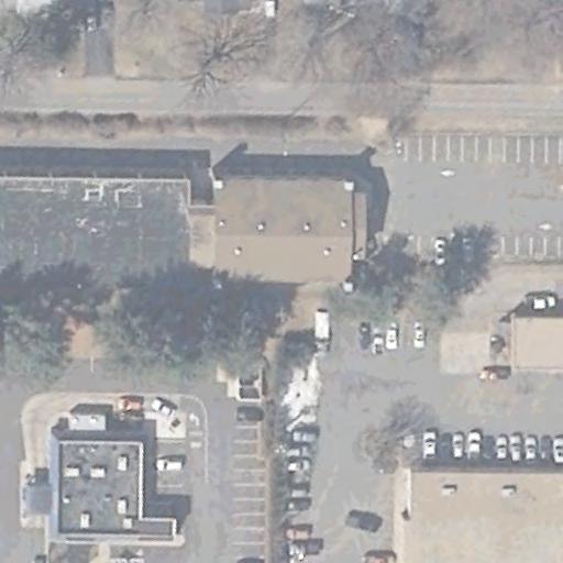
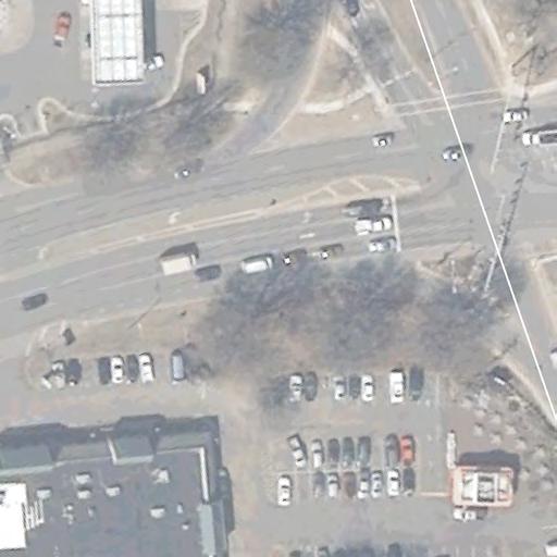
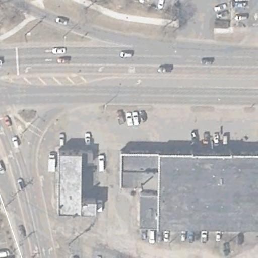
5 Intersection Traffic Analysis Broadview rost Ave / Waterloo St Broadview Avenue Access Management Improvements September, 2015 I. INTROUCTION As requested by the Virginia epartment of Transportation (VOT), Wallace Montgomery (WM) has developed the following report to evaluate the existing and future intersection capacity and operations of the US 211/ US 17/ 29 Business (Broadview Avenue) and US 211 (rost Avenue)/ US 211 Business (Waterloo Street) intersection in the Town of Warrenton. As part of the Broadview Avenue Access Management Improvement project, this report includes a summary of the existing and future 2040 horizon year traffic volumes and analyses at the study intersection to identify the operational deficiencies. Solutions to improve intersection operations that could be incorporated into the project were then determined. A. Project escription The Project is located in the Town of Warrenton, auquier County, Virginia. The project limits begin south of the US 211 (rost Avenue)/ US 211 Business (Waterloo Street) intersection and the northern limit is south of the US 17/ Winchester Street intersection. This study focuses on the Broadview Avenue (US 211/ US 17/29 Bus)/ Shirley Avenue (US 17/29 Bus) at rost Avenue (US 211)/ Waterloo Street (US 211 Bus) intersection at the southern limits of the project. igure 1 displays a map of the study corridor and intersection. Broadview Avenue, throughout the project limits, is categorized as an Urban Other Principal Arterial. The typical roadway section throughout the majority of the project limits consists of a six-lane cross section with two thru lanes and a striped continuous left-turn lane in each direction, creating corridor-wide opposing left turn lanes. Roadway geometrics vary at the signalized study intersection at US 211 (rost Avenue)/ US 211 Business (Waterloo Street). The posted speed limit is 40 mph along Broadview Avenue and rost Avenue and 25 mph along Waterloo Street. B. Proposed Improvements The focus of the Broadview Avenue Access Management Improvement project is to construct raised medians and dedicated left turn lanes at strategic locations within the project corridor limits to improve safety. Proposed improvements will also include milling and resurfacing of the existing roadway, bicycle and pedestrian improvements (AA upgrades), signing, pavement marking, signalization and lighting modifications. Alternative geometric layouts for the signalized study intersection of Broadview/ Shirley Avenue at rost Avenue/ Waterloo Street are also being investigated by the esign Team. Proposed geometric improvements at this intersection may require base roadway widening, full depth pavement reconstruction, traffic signal modifications or total intersection reconstruction in order to properly address operational deficiencies. Page 1
 Broadview/Shirley Avenue at rost Avenue/ Waterloo Street is a four-legged signalized intersection.")

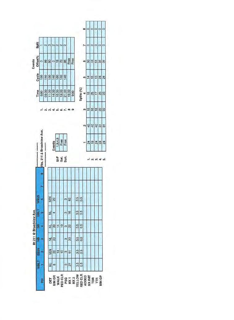
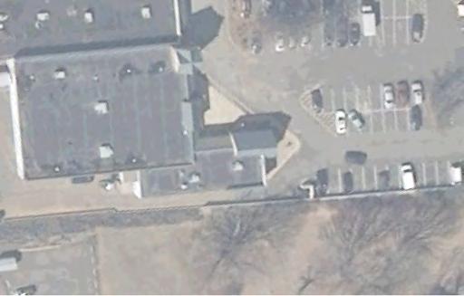
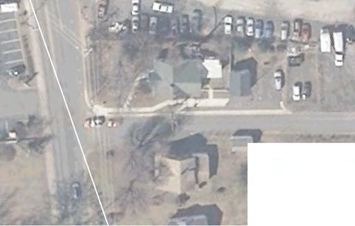
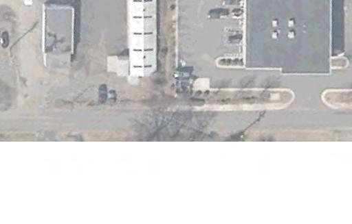
6 Intersection Traffic Analysis Broadview rost Ave / Waterloo St Broadview Avenue Access Management Improvements September, 2015 II. XISTING CONITIONS A. xisting Intersection Control igure 1 Study Location Map (Google Maps) Broadview/Shirley Avenue at rost Avenue/ Waterloo Street is a four-legged signalized intersection. The signal control is a NMA six-phase actuated un-coordinated system, with protected left-turn movements along the mainline Broadview/ Shirley Avenue approaches and split phasing along the minor rost Avenue/ Waterloo Street approaches. edicated left-turn lanes are provided along the Broadview/ Shirley Avenue approaches and dedicated channelized right-turn lanes are provided along all four approaches under yield control. Signalized pedestrian-actuated marked crossings are provided across all four legs of the intersection with uncontrolled marked crossing across the channelized right-turn lanes. Photos of the study intersection are provided in Appendix A, and existing signal timings and plans are included in Appendix B. Page 2
7 Intersection Traffic Analysis Broadview rost Ave / Waterloo St Broadview Avenue Access Management Improvements September, 2015 B. xisting Volumes A thirteen (13) hour turning movement count of vehicular, pedestrian and bicycle traffic was performed on Thursday, October 24, 2014 and Saturday, October 26, 2014 at the Broadview/ Shirley Avenue and rost Avenue/ Waterloo Street study intersections. Public schools were in session during the weekday count, and no special events in Warrenton were taking place during the weekend count. The Virginia Gold Cup Steeplechase was taking place in nearby The Plains that Saturday, which may have slightly increased traffic volumes along Broadview Avenue and rost Avenue. AM, PM and Saturday peak hour volumes are summarized in igure 2, and detailed traffic count data is included in Appendix C. C. xisting Operations igure 2 xisting 2014 Peak Hour Volumes Operational analyses of the existing peak hour volumes were developed for the study intersection in accordance with the Highway Capacity Manual (HCM) technique for signalized intersections using the Synchro 9 and SimTraffic modeling software. The HCM technique quantifies a Level of Service (LOS) grade for an intersection based on average vehicle delay. Table 1 summarizes the meaning of the various LOS grades (A - ) for various types of intersection control. Page 3
8 Intersection Traffic Analysis Broadview rost Ave / Waterloo St Broadview Avenue Access Management Improvements September, 2015 LOS Signalized Control elay (sec/veh) Table 1 Level of Service Criteria Stop/ Roundabout Control elay Characteristics (sec/veh) A <= 10.0 <= 10.0 ree traffic flow with high level of maneuverability B C > 80.0 > 50.0 Stable traffic flow with maneuverability affected by other users within traffic stream Stable traffic flow with maneuverability affected by other users within traffic stream High density but stable traffic flow with speed and freedom to maneuver in traffic stream severely restricted Unstable traffic flow with freedom to maneuver in traffic stream very difficult Breakdown in traffic flow with queues forming and operations within traffic stream characterized by stop and go Overall LOS Table 2 summarizes the HCM LOS results, Table 3 summarizes the resulting 95 th percentile queues based on SimTraffic analyses, and detailed analysis worksheets are included in Appendix. Currently the rost Avenue/ Waterloo Street intersection operates at a deficient LOS during the PM and Saturday peak hours, with significant delay and queues experienced along the Broadview/ Shirley Avenue and eastbound rost Avenue approaches. The eastbound rost Avenue and northbound Shirley Avenue left-turn and southbound Broadview Avenue right-turn movements exhibit most of the operational deficiencies. Table 2 xisting 2014 Intersection LOS Summary Level of Service Per Movement By Approach (elay in sec/veh) astbound rost Westbound Waterloo Northbound Shirley Southbound Broadview LT TH RT LT TH RT LT TH RT LT TH RT AM Peak Hour (46.4) (112.4) (102.2) (40.7) (96.5) (246.4) (40.4) (96.3) (248.9) C (28.1) (49.0) (41.2) (59.1) (56.9) (60.7) (49.3) (113.8) (355.3) (248.7) (46.1) C (28.9) C (21.8) (40.2) C (23.3) B (17.9) (87.2) (61.7) (57.0) (43.0) (38.5) (58.2) (67.1) (39.4) (83.3) (53.2) PM Peak Hour (49.0) (91.5) (77.8) (145.5) (113.3) SATURAY Peak Hour B (19.6) (213.3) (51.4) (87.2) (55.8) C (25.4) (158.0) (75.0) Page 4
9 Intersection Traffic Analysis Broadview rost Ave / Waterloo St Broadview Avenue Access Management Improvements September, 2015 Table 3 xisting 2014 Intersection Queuing Summary irection Movement Storage Length Available (ft) 95th Percentile Queue Length (ft) AM PM SAT B WB NB SB Southbound PM thru queues include right turn queues spilling back into the thru lane. III. UTUR CONITIONS A. uture Volumes L LT R LT TH R L TH R L TH R uture 2040 volumes were developed by increasing the 2014 volumes along Broadview Avenue, Shirley Avenue and rost Avenue using a nominal 0.70% annual growth rate as directed by VOT. Volumes along Waterloo Street were not adjusted as development along this roadway has saturated conditions and future traffic growth will be negligible. The AA/ Access Management/ Traffic Assessment Report proposed a raised median along Broadview Avenue, which will result in additional left-turn and U-turn movements anticipated at the rost Avenue/ Waterloo Street intersection. The additional turning movements were included in the future volumes for this study. uture AM, PM and Saturday peak hour volumes are summarized in igure 3. Page 5
10 Intersection Traffic Analysis Broadview rost Ave / Waterloo St Broadview Avenue Access Management Improvements September, 2015 B. uture No-Build Operations igure 3 uture 2040 Peak Hour Volumes Operational analyses of the future 2040 peak hour volumes were developed for the study intersection under existing geometric and signal control (no-build) in accordance with the HCM technique. Signal timing and splits were optimize to adjust for the revised volumes. Table 4 summarizes the LOS results, Table 5 summarizes the resulting queues, and detailed analysis worksheets are included in Appendix. The rost Avenue/ Waterloo Street intersection will operate at a deficient LOS during all peak hours, with continued significant delays and queues experienced along the Broadview/ Shirley Avenue and eastbound rost Avenue approaches. Page 6
11 Intersection Traffic Analysis Broadview rost Ave / Waterloo St Broadview Avenue Access Management Improvements September, 2015 Table 4 uture 2040 No-Build Intersection LOS Summary Overall LOS Level of Service Per Movement By Approach (elay in sec/veh) astbound rost Westbound Waterloo Northbound Shirley Southbound Broadview LT TH RT LT TH RT LT TH RT LT TH RT AM Peak Hour (59.0) (56.8) (55.3) C (30.0) (59.7) (57.0) (167.8) (48.4) (40.9) (73.4) (48.7) (51.7) (58.6) (85.4) (50.7) (46.5) PM Peak Hour (192.7) (173.9) (373.7) (415.5) (373.5) (422.8) (54.2) (52.8) (84.7) (61.1) (54.9) (57.5) (620.3) (290.5) C (28.7) C (32.5) C (22.0) C (25.5) (73.7) (74.9) (27.7) (340.8) (192.7) (238.6) (135.5) SATURAY Peak Hour C (26.6) (358.2) (59.4) (106.5) (139.2) (211.8) (211.7) Table 5 uture 2040 No-Build Approach Queuing Summary irection Movement Storage Length Available (ft) 95th Percentile Queue Length (ft) AM PM SAT L B LT R LT WB TH R L NB TH R L SB TH R Southbound PM and Saturday thru queues include right turn queues spilling back into the thru lane. Page 7
12 Intersection Traffic Analysis Broadview rost Ave / Waterloo St Broadview Avenue Access Management Improvements September, 2015 IV. ALTRNATIV GOMTRIC IMPROVMNTS The Broadview/ Shirley Avenue and rost Avenue/ Waterloo Street intersection was further evaluated to determine the geometric improvements required to mitigate the operational deficiencies. Various alternative lane configurations, signal phases/ timings and intersection control were reviewed to increase capacity and traffic flow through the intersection. A. Alternative 1 Southbound ree Right-Turn and Second Northbound Left-Turn Providing an acceleration lane serving the existing southbound Broadview Avenue rightturn lane and a second northbound Shirley Avenue left-turn lane will address most of the capacity deficiencies. The addition of the acceleration lane for the southbound right-turn movement would reduce the need for right-turn traffic to yield, thereby reducing the delay and resulting queues that impact the adjacent southbound travel lanes. The addition of a second northbound left-turn lane would provide additional capacity through the intersection for this high volume movement. The northbound Shirley Avenue separate channelized right-turn lane can be removed, providing a shared thru-right turn lane without adversely impacting the intersection operations. The signal timing cycle length and approach splits would require to be optimized to efficiently accommodate the proposed configurations. The existing and proposed lane configuration improvements and recommended dedicated turn lane lengths are displayed in igure 4, and a conceptual design plan is provided in Appendix. igure 4 Alternative 1 Lane Configurations Providing an acceleration lane for the southbound Broadview Avenue right-turn would require base widening along westbound rost Avenue, west of the study intersection. An acceleration lane and taper length of approximately 300 feet each can be accommodated without impacting the existing culvert along westbound rost Avenue. These lengths are AASHTO compliant based on an entrance design speed of 30 mph merging into a travel lane at 40 mph (the posted speed along rost Avenue that is introduced downstream at the culvert). It is recommended to reconstruct the southbound channelized right-turn island with a smaller 30 mph design radius (275 feet) to accommodate the base widening and create additional acceleration length. Page 8
13 Intersection Traffic Analysis Broadview rost Ave / Waterloo St Broadview Avenue Access Management Improvements September, 2015 xisting access to Rappahannock Street and two commercial driveways are located along westbound rost Avenue within the limits of the proposed acceleration lane. The installation of the acceleration would eliminate the dedicated auxiliary lane conditions to these access points, where the taper for the acceleration lane would be located within the commercial driveways. The proposed conditions would create a weave condition between the southbound Broadview Avenue right-turn traffic and traffic accessing to/from the commercial driveway, which produces a potentially unsafe condition for the access points. Providing a second left-turn lane along northbound Shirley Avenue would require the south leg median to be reconstructed, and the existing southbound dedicated left-turn lanes to access the commercial driveways along northbound Shirley Avenue, south of the study intersection, would be impacted. Signal modifications would be required to accommodate a second northbound left-turn lane signal, and removing the Shirley Avenue channelized island would require replacing the existing mast arm pole. However the southbound right-turn lane improvements would not impact the existing signal. The existing pedestrian marked crossings across the southbound right-turn lane would remain uncontrolled. B. Alternative 2 Second Southbound Signalized Right-Turn and Second Northbound Left-Turn Providing a second southbound Broadview Avenue right-turn lane and a second northbound Shirley Avenue left-turn lane will also address most of the capacity deficiencies. The addition of the second southbound right-turn lane would require the right turn movement to be signalized with permissive right-turn overlap phasing concurrent with the eastbound rost Avenue phase. The left-most right turn lane would be prohibited to turn on a red signal indication. The northbound Shirley Avenue improvements and impacts are the same as Alternative 1. The signal timing cycle length and approach splits would require to be optimized to efficiently accommodate the proposed configurations. The existing and proposed lane configuration improvements and recommended dedicated turn lane lengths are displayed in igure 5, and a conceptual design plan is provided in Appendix. igure 5 Alternative 2 Lane Configurations Page 9
14 Intersection Traffic Analysis Broadview rost Ave / Waterloo St Broadview Avenue Access Management Improvements September, 2015 Providing a second southbound Broadview Avenue right-turn lane would require southbound base widening that will impact the adjacent commercial driveways, and the right-turn channelization island would need to be significantly reduced. In addition to the signal impacts as described for Alternative 1; Alternative 2 would impact the existing signal controller cabinet, signal poles, junction boxes, conduit and associated cable within the southbound right-turn channelization island. The signalization for the southbound double right-turn lanes would require an additional mast arm. The existing signal would need to be reconstructed to accommodate the additional signalization and impacts to the channelized island. The proposed southbound Broadview Avenue right-turn improvements will improve pedestrian accommodations by providing a controlled marked crossing with the signalization. C. Alternatives 1 and 2 Intersection Improvement Operations Operational analyses of the alternative signalized intersection improvements using future 2040 peak hour volumes were developed for the study intersection in accordance with the 2010 HCM technique. It is understood that fully incorporating the proposed improvements to northbound Shirley Avenue may not fit within the intended scope of the project. Therefore analyses were developed with and without the inclusion of northbound Shirley Avenue improvements to understand the operational effects if these improvements were not included in the project. Tables 6 and 7 summarize the LOS and resulting queues without the northbound improvements, Tables 8 and 9 summarize the LOS and resulting queues with the northbound improvements, and detailed analysis worksheets are included in Appendix G. Both alternatives provide similar operational results, both with and without the northbound improvements. The northbound improvement has the most impact on the PM operations, resulting in acceptable northbound approach and overall LOS during this peak hour if implemented. The overall LOS during the Saturday peak period will be at unacceptable levels due to significant delays along the eastbound rost Avenue approach for both alternatives. Page 10
15 Intersection Traffic Analysis Broadview rost Ave / Waterloo St Broadview Avenue Access Management Improvements September, 2015 Table 6 Proposed Alternatives 1 and 2 Intersection LOS Summary Without Northbound Improvements Proposed Alternative Overall LOS Level of Service Per Movement By Approach (elay in sec/veh) astbound rost Westbound Waterloo Northbound Shirley Southbound Broadview LT TH RT LT TH RT LT TH RT LT TH RT AM Peak Hour Alternative 1 Single ree SB RT Alternative 2 ouble SB RT Alternative 1 Single ree SB RT Alternative 2 ouble SB RT Alternative 1 Single ree SB RT Alternative 2 ouble SB RT (46.2) (47.7) (69.8) (84.3) (68.3) (73.0) (46.9) (46.9) (76.3) (63.6) (209.2) (209.2) (46.1) (46.1) (76.3) (63.9) (211.8) (211.8) C (27.4) C (27.4) (42.1) (39.6) (37.0) (37.0) (63.7) (60.5) (60.5) (56.0) (56.0) SATURAY Peak Hour (55.4) (49.1) (49.1) (109.9) (109.9) (303.6) (424.9) (72.0) (72.0) (48.7) (48.7) (49.5) (53.6) C (31.6) C (31.6) (41.1) (41.1) (36.8) (39.3) C (24.3) C (24.3) (73.4) (73.4) (100.9) (80.3) (62.9) (62.9) (52.0) (43.3) (62.4) (67.5) C (32.1) (63.7) (43.3) (62.4) PM Peak Hour (72.4) (72.8) (68.4) (72.4) (61.3) (68.4) (52.0) (67.5) (36.0) (59.8) (143.9) C (22.7) (58.9) (185.1) (42.2) C (33.3) (181.6) (52.4) (43.0) B (19.8) (181.6) (55.4) C (33.3) (52.4) (43.0) C (30.3) Since a left-most signalized double right-turn lane is prohibited to turn under a red indication and Synchro cannot accurately model this condition, Alternative 2 was modelled with the southbound double right-turn movement prohibited to turn on red as a worse-case scenario. A (0.5) A (11.0) A (3.9) C (26.6) A (4.6) C (22.5) Page 11
16 Intersection Traffic Analysis Broadview rost Ave / Waterloo St Broadview Avenue Access Management Improvements September, 2015 Table 7 Proposed Alternatives 1 and 2 Approach Queuing Summary Without Northbound Improvements Proposed Alternative Alternative 1 Single ree SB RT Alternative 2 ouble SB RT irection B WB NB SB B WB NB SB Movement Storage Length Available (ft) 95th Percentile Queue Length (ft) AM PM SAT L LT R LT TH R L TH R L TH R L LT R LT TH R L TH R L TH R Page 12
17 Intersection Traffic Analysis Broadview rost Ave / Waterloo St Broadview Avenue Access Management Improvements September, 2015 Proposed Alternative Table 8 Proposed Alternatives 1 and 2 Intersection LOS Summary With Northbound Improvements Overall LOS astbound rost Level of Service Per Movement By Approach (elay in sec/veh) Westbound Waterloo Northbound Shirley Southbound Broadview LT TH RT LT TH RT LT TH RT LT TH RT AM Peak Hour Alternative 1 Single ree SB RT (42.6) (53.2) (52.2) A (4.6) (67.1) B (15.1) (73.7) (48.3) (80.9) (46.1) (44.6) (46.3) (56.2) C (29.6) A (0.5) Alternative 2 ouble SB RT (44.8) (49.2) (48.2) C (28.1) (63.7) (60.5) (69.3) (45.2) (62.4) (55.0) (48.5) (73.4) (46.1) C (32.6) A (9.0) Alternative 1 Single ree SB RT Alternative 2 ouble SB RT Alternative 1 Single ree SB RT Alternative 2 ouble SB RT (50.6) (55.7) (66.5) (69.6) (77.8) (65.9) (209.2) (209.2) (78.0) (66.0) (211.8) (211.8) (42.3) (40.1) (37.0) (37.0) (73.3) (56.2) (56.2) (49.1) (49.1) (89.1) (98.7) (53.4) (53.4) (49.9) (53.7) C (32.0) C (32.0) (80.3) (80.3) (62.9) (62.9) C (52.9) (74.3) (69.2) (63.8) C (20.1) (181.7) PM Peak Hour (73.3) (63.3) (69.2) (69.7) SATURAY Peak Hour (55.4) (55.4) (52.4) (38.1) (55.7) (40.3) C (27.4) (181.6) (52.4) (38.1) B (18.0) C (27.4) C (24.9) Since a left-most signalized double right-turn lane is prohibited to turn under a red indication and Synchro cannot accurately model this condition, Alternative 2 was modelled with the southbound double right-turn movement prohibited to turn on red as a worse-case scenario. A (3.9) C (25.4) A (4.6) B (16.4) Page 13
18 Intersection Traffic Analysis Broadview rost Ave / Waterloo St Broadview Avenue Access Management Improvements September, 2015 Table 9 Proposed Alternatives 1 and 2 Approach Queuing Summary With Northbound Improvements Proposed Alternative Alternative 1 Single ree SB RT Alternative 2 ouble SB RT irection B WB NB SB B WB NB SB. Alternative 3 Two-Lane Roundabout Storage Movement Length 95th Percentile Queue Length (ft) Available (ft) AM PM SAT L LT R LT TH R L TH TR L TH R L LT R LT TH R L TH TR L TH R A two-lane roundabout was also evaluated at the study intersection to determine if this alternative control would be geometrically and operationally feasible. igure 6 displays the proposed roundabout configuration, and a conceptual design plan is provided in Appendix. The following impacts and concerns are associated with the installation of a two-lane roundabout: Significant right-of-way impacts to the adjacent properties in the northeast and southeast corner from base widening of the east leg along Waterloo Street. Some base widening is required for the north leg along Broadview Avenue. riveway to the adjacent northeast corner property would be impacted. Construction costs and the complexity of maintenance of traffic phasing would be significantly more than Alternatives 1 and 2. There would be more marked pedestrian crossings, where all crossings would be Page 14
19 Intersection Traffic Analysis Broadview rost Ave / Waterloo St Broadview Avenue Access Management Improvements September, 2015 unprotected. This is a safety concern, when a priority of this project is to improve pedestrian accessibility. Ingress to Rappahannock Street from the circulating lane to westbound rost Avenue requires crossing the southbound Broadview Avenue right-turn entrance lane, which has little weaving room. The diameter of the roundabout shown in Appendix would require large trucks to utilize both lanes in the circle. A larger diameter roundabout with wider circulating lanes would further increase the footprint of the roundabout and increase outside impacts. igure 6 Alternative 3 Roundabout Lane Configuration Operational analyses of the two-lane roundabout using future 2040 peak hour volumes were developed for the study intersection using the SIRA roundabout modeling software, using both the SIRA Standard and the 2015 HCM capacity model methods (updated capacity calibrations to the 2010 HCM model in SIRA). VOT s operational analysis guidelines recommend the SIRA Standard model; however the latest 2015 HCM model was included to compare the resulting delay LOS and queues. Table 10 summarizes the LOS results and Table 11 summarizes the resulting queues based on the SIRA model method, and Tables 12 and 13 summarize the LOS and queue results based on the HCM 2015 model method. Resulting operational analysis worksheets are included in Appendix G. The results of the SIRA Standard model indicate very promising operations with Page 15
20 Intersection Traffic Analysis Broadview rost Ave / Waterloo St Broadview Avenue Access Management Improvements September, 2015 Overall LOS A (9.0) B (13.6) acceptable LOS and queues along all approaches of the roundabout during all peak hours. By contrast the 2015 HCM model results indicate several operational deficiencies during all peak hours. The northbound Shirley Avenue and eastbound rost Avenue approach exhibit unacceptable LOS during all peak hours, with unacceptable overall intersection LOS during the PM and Saturday peak hours. Westbound Waterloo Street exhibits high delays and queues during the PM peak hour, northbound Shirley Avenue exhibits significant queues during the PM peak hour, and eastbound rost Avenue also exhibits significant queues during the Saturday peak hour. A third circulating lane would be required to mitigate these operational deficiencies, which is not considered a feasible intersection design. Compared to Alternatives 1 and 2 based on the 2015 HCM model, Alternative 3 exhibits similar LOS results during the AM and Saturday peak hours (though with lower delay). However the PM operations are worse with the two-lane roundabout. The SIRA Standard model results for Alternative 3 far exceed Alternative 1 and 2. Table 10 Alternative 3 Roundabout LOS Summary (SIRA Standard) LT TH RT LT TH RT LT TH RT LT TH RT AM Peak Hour B (13.3) C (16.3) C (17.2) B (12.4) B (14.7) C (15.6) Level of Service Per Movement By Approach (elay in sec/veh) astbound rost Westbound Waterloo Northbound Shirley Southbound Broadview B (12.4) B (14.7) C (15.6) A (7.2) (26.5) A (10.0) A (7.2) (26.5) A (10.0) A (8.8) B (13.2) B (14.7) B (12.3) C (22.3) C (21.1) B (10.6) C (19.7) C (18.4) B (10.2) C (19.2) C (17.6) A (5.0) C (15.2) A (7.4) A (4.5) B (13.0) A (7.8) B (11.1) A (2.6) PM Peak Hour B (13.2) C (15.9) C (23.3) C (20.6) A (6.0) SATURAY Peak Hour A (6.5) B (10.5) C (16.7) B (12.2) C (19.2) A (3.1) LOS criteria for roundabouts are same as stop controlled intersections (see Table 1) A (0.0) A (0.0) A (0.0) Page 16
21 Intersection Traffic Analysis Broadview rost Ave / Waterloo St Broadview Avenue Access Management Improvements September, 2015 Table 11 Alternative 3 Roundabout Approach Queuing Summary (SIRA Standard) Storage 95th Percentile Queue Length Length irection Movement (ft) Available (ft) AM PM SAT B L LTR WB LT R NB LT TR LT SB TH R Overall LOS (28.4) (74.5) (49.8) Table 12 Alternative 3 Roundabout LOS Summary (HCM 2015) LT TH RT LT TH RT LT TH RT LT TH RT (38.3) (43.9) (101.9) (36.6) (41.6) (99.2) Level of Service Per Movement By Approach (elay in sec/veh) astbound rost Westbound Waterloo Northbound Shirley Southbound Broadview (36.6) (41.6) (99.2) C (23.5) (336.1) (44.7) C (23.5) (336.1) (44.7) AM Peak Hour B (13.4) C (15.7) (52.4) (119.1) SATURAY Peak Hour C (21.9) (93.3) (48.5) (115.9) (89.6) LOS criteria for roundabouts are same as stop controlled intersections (see Table 1) (47.3) (115.1) (88.3) A (7.7) C (21.7) B (13.9) A (7.7) (37.7) C (19.5) (49.7) A (4.2) PM Peak Hour C (21.7) (43.3) (258.5) (117.0) A (9.6) B (13.9) (101.1) (34.0) (90.6) A (6.0) A (0.0) A (0.0) A (0.0) Page 17
22 Intersection Traffic Analysis Broadview rost Ave / Waterloo St Broadview Avenue Access Management Improvements September, 2015 Table 13 Alternative 3 Roundabout Approach Queuing Summary (HCM 2015) Storage 95th Percentile Queue Length Length irection Movement (ft) Available (ft) AM PM SAT B L LTR WB LT R NB LT TR LT SB TH R The geometric impacts and costs of installing a two-lane roundabout are more significant than Alternatives 1 and 2. Therefore Alternative 3 is not recommended for this project.. Additional Intersection Improvement Considerations Additional intersection improvements were evaluated that did not provide better resulting operational improvements as Alternatives 1-3 for the study intersection and therefore were not carried forward for further study. Other eastbound rost Avenue lane configurations separating the left-turn movements and changing signal phasing and timings proved to be ineffective to improve the Saturday peak hour operations at this intersection without adversely impacting the operations during the weekday peak hours. Providing a southbound Broadview Avenue free right-turn using the right-most (outer) westbound rost Avenue travel lane as an add-lane and limiting a single through movement along the westbound Waterloo Street approach resulted in significant adverse operational impacts during the PM peak hour. A Continuous low Intersection (CI) design would require a much larger footprint that would expand the limits of work and limit access to adjacent businesses. A CI would also create unsafe pedestrian crossing conditions by increasing the crossing lengths, which is counterintuitive to the purpose and need of this project. Additional signalization and interconnect would be required, further increasing the cost of the intersection improvement. A Superstreet or Median U-Turn design would not work operationally with the high leftturn volumes at this intersections. Page 18
23 Intersection Traffic Analysis Broadview rost Ave / Waterloo St Broadview Avenue Access Management Improvements September, 2015 V. SUMMARY AN RCOMMNATIONS The operations of the Broadview/ Shirley Avenue and rost Avenue/ Waterloo Street intersection were evaluated based on existing and future 2040 volume conditions with proposed raised median improvements along Broadview Avenue. The intersection will operate at an unacceptable LOS under existing geometry and control conditions during peak hour times in the future; and various alternative intersection improvements were evaluated to mitigate the operational deficiencies with minimal impacts to adjacent properties, driveway access and pedestrian accessibility. The following two alternative geometric intersection improvements provided the most desirable results: 1. Alternative 1 Providing a single free southbound Broadview Avenue right-turn with a westbound rost Avenue acceleration/ weave lane and a second northbound Shirley Avenue left-turn lane under signal control 2. Alternative 2 Providing a double signalized southbound Broadview Avenue right-turn and a second northbound Shirley Avenue left-turn lane under signal control Both alternatives produce similar resulting LOS at the study intersection, and not providing the northbound geometric improvements resulted in unacceptable LOS during the PM peak hour. Alternative 1 requires less base widening along southbound Broadview Avenue and less signal impacts. However it requires base widening along rost Avenue, produces unsafe weaving and access conditions to Rappahannock Street and commercial driveways along westbound rost Avenue, and does not improve pedestrian safety across the southbound Broadview Avenue right-turn movement. Alternative 2 requires base widening along southbound Broadview Avenue and more significant modifications to the existing signal at the study intersection. However it has minimal impacts to westbound rost Avenue and improves pedestrian safety across the southbound Broadview Avenue right-turn movement with signal control. It is recommended to construct the northbound and southbound Alternative 2 geometric improvements for the Broadview Avenue Access Management project (if the budget allows). This alternative provides improved safety for pedestrians and access along westbound rost Avenue while improving overall operations at the study intersection. Page 19
24 Intersection Traffic Analysis Broadview rost Ave / Waterloo St Broadview Avenue Access Management Improvements September, 2015 APPNIX A xisting Intersection Photographs


25 astbound rost Avenue Approach Looking ast Waterloo Street Approach Looking ast


26 Shirley Avenue Approach Looking North Broadview Avenue Approach Looking North


27 Westbound rost Avenue at Rappahannock Street Looking ast Westbound rost Avenue at Broadview Avenue Looking West
28 Intersection Traffic Analysis Broadview rost Ave / Waterloo St Broadview Avenue Access Management Improvements September, 2015 APPNIX B xisting Signal Timing and Plans
29
30
31
32
33
34
35
36 Intersection Traffic Analysis Broadview rost Ave / Waterloo St Broadview Avenue Access Management Improvements September, 2015 APPNIX C Turning Movement Counts
37 Request No.: Job No.: Location: Broadview Avenue/ W. Shirley rost Avenue/ Waterloo Street County: auquier, VA ate: 10/23/2014 Thursday Town: Warrenton Recorder: LCM JM Weather: Clear, Cool Interval (dd) : 15 (In Minutes) PAK AM PRIO Start nd Volume PM PRIO Start nd Volume HOURS 6:00AM-12:00PM 07:00 08: :00PM-7:00PM 16:45 17: Street Name--> Broadview Avenue W. Shirley Avenue Waterloo Street rost Avenue HOUR rom North rom South rom ast rom West GRAN NING L T R TOT L T R TOT L T R TOT L T R TOT TOTAL 00: : : : : : : : : : : : : : : : : : : : : : : : : : : : : : : : : : : : : : : : : : : : : : : : : : : : : : : : : : : : : : : : : : : : : : : : : : : : : : : : : : : : : : : : : : : : : : : : TOTAL AM Peak Vol PM Peak Vol
38 Request No.: Job No.: Location: Broadview Avenue/ W. Shirley rost Avenue/ Waterloo Street County: auquier, VA ate: 10/23/2014 Thursday Town: Warrenton Recorder: LCM JM Weather: Clear, Cool Interval (dd) : 15 (In Minutes) PAK HOURS AM PRIO 6:00AM-12:00PM Start nd Volume PM PRIO Start nd Volume 07:00 08: :00PM-7:00PM 16:45 17: PSTRIAN SCHOOL CHILRN & U-TURN BRAKOWN Hour Broadview Avenue W. Shirley Avenue Waterloo Street rost Avenue nding BIKS P. U.T. BIKS P. U.T. BIKS P. U.T. BIKS P. U.T. 00:15 00:30 00:45 01:00 01:15 01:30 01:45 02:00 02:15 02:30 02:45 03:00 03:15 03:30 03:45 04:00 04:15 04:30 04:45 05:00 05:15 05:30 05:45 06:00 06: : : : : : : : : : : : : : : : : : : : : : : : : : : : : : : : : : : : : : : : : : : : : : : : : : : : :15 19:30 19:45 20:00 20:15 20:30 20:45 21:00 21:15 21:30 21:45 22:00 22:15 22:30 22:45 23:00 23:15 23:30 23:45 00:00 TOTAL AM Peak Vol PM Peak Vol
39 Request No.: Job No.: Location: Broadview Avenue/ W. Shirley rost Avenue/ Waterloo Street County: auquier, VA ate: 10/23/2014 Thursday Town: Warrenton Recorder: LCM JM Weather: Clear, Cool Interval (dd) : 15 (In Minutes) PAK HOURS AM PRIO 6:00AM-12:00PM Start nd Volume PM PRIO Start nd Volume 07:00 08: :00PM-7:00PM 16:45 17: Turning Movement Summary: LG 1 Quadrant Total Broadview Avenue R T L U Quadrant Total LG 4 rost Avenue U R L T T L R U Waterloo Street LG Quadrant Total U L T R 1008 W. Shirley Avenue LG 2 Quadrant Total Comments: AM Peak Hour : X:XX A.M. - X:XX A.M LG 1 Quadrant Total Broadview Avenue 1080 R T L U Quadrant Total LG 4 rost Avenue U 1 86 R L T T L R U Waterloo Street LG Quadrant Total U L T R 57 W. Shirley Avenue LG 2 Quadrant Total PM Peak Hour : X:XX P.M. - X:XX P.M LG 1 Quadrant Total Broadview Avenue 1409 R T L U Quadrant Total LG 4 rost Avenue U R L T T L 632 R 65 0 U 211 Waterloo Street LG Quadrant Total U L T R 87 W. Shirley Avenue LG Quadrant Total
40 Intersection Traffic Analysis Broadview rost Ave / Waterloo St Broadview Avenue Access Management Improvements September, 2015 APPNIX xisting Operational Analyses
41 HCM Signalized Intersection Capacity Analysis 22: Shirley Ave/Broadview Ave & rost/waterloo St 2/17/2015 Movement BU BL BT BR WBL WBT WBR NBU NBL NBT NBR SBU Lane Configurations Volume (vph) Ideal low (vphpl) Total Lost time (s) Lane Util. actor rt lt Protected Satd. low (prot) lt Permitted Satd. low (perm) Peak-hour factor, PH Adj. low (vph) RTOR Reduction (vph) Lane Group low (vph) Turn Type Perm Split NA Perm Split NA Perm custom Prot NA Perm custom Protected Phases Permitted Phases Actuated Green, G (s) ffective Green, g (s) Actuated g/c Ratio Clearance Time (s) Vehicle xtension (s) Lane Grp Cap (vph) v/s Ratio Prot 0.29 c0.04 c0.11 v/s Ratio Perm c c v/c Ratio Uniform elay, d Progression actor Incremental elay, d elay (s) Level of Service C Approach elay (s) Approach LOS Intersection Summary HCM 2000 Control elay HCM 2000 Level of Service HCM 2000 Volume to Capacity ratio 1.27 Actuated Cycle Length (s) Sum of lost time (s) 16.0 Intersection Capacity Utilization 77.8% ICU Level of Service Analysis Period (min) 15 c Critical Lane Group Broadview Ave 11/3/2014 AM xisting Synchro 9 Report PC Page 10
42 Queuing and Blocking Report AM xisting 2/17/2015 Intersection: 16: Broadview Ave & Church St Movement WB SB irections Served LR UL Maximum Queue (ft) Average Queue (ft) th Queue (ft) Link istance (ft) 511 Upstream Blk Time (%) Storage Bay ist (ft) 400 Storage Blk Time (%) Intersection: 22: Shirley Ave/Broadview Ave & rost/waterloo St Movement B B WB WB WB NB NB NB NB SB SB SB irections Served UL LT LT T R UL T T R UL T T Maximum Queue (ft) Average Queue (ft) th Queue (ft) Link istance (ft) Upstream Blk Time (%) Storage Bay ist (ft) Storage Blk Time (%) 3 1 Network Summary Network wide Queuing Penalty: 13 Broadview Ave SimTraffic Report PC Page 4
43 Lanes, Volumes, Timings 22: Shirley Ave/Broadview Ave & rost/waterloo St 2/17/2015 Lane Group BL BT BR WBL WBT WBR NBL NBT NBR SBL SBT SBR Lane Configurations Volume (vph) Ideal low (vphpl) Storage Length (ft) Storage Lanes Taper Length (ft) Lane Util. actor rt lt Protected Satd. low (prot) lt Permitted Satd. low (perm) Right Turn on Red Yes Yes Yes Yes Satd. low (RTOR) Link Speed (mph) Link istance (ft) Travel Time (s) Peak Hour actor Adj. low (vph) Shared Lane Traffic (%) 40% Lane Group low (vph) nter Blocked Intersection No No No No No No No No No No No No Lane Alignment Left Left Right Left Left Right Left Left Right Left Left Right Median Width(ft) Link Offset(ft) Crosswalk Width(ft) Two way Left Turn Lane Headway actor Turning Speed (mph) Number of etectors etector Template Left Thru Right Left Thru Right Left Thru Right Left Thru Right Leading etector (ft) Trailing etector (ft) etector 1 Position(ft) etector 1 Size(ft) etector 1 Type Cl+x Cl+x Cl+x Cl+x Cl+x Cl+x Cl+x Cl+x Cl+x Cl+x Cl+x Cl+x etector 1 Channel etector 1 xtend (s) etector 1 Queue (s) etector 1 elay (s) etector 2 Position(ft) etector 2 Size(ft) etector 2 Type Cl+x Cl+x Cl+x Cl+x etector 2 Channel etector 2 xtend (s) Turn Type Split NA Perm Split NA Perm Prot NA Perm Prot NA Perm Protected Phases Permitted Phases etector Phase Broadview Ave 11/4/2014 PM xisting Synchro 9 Report PC Page 19
44 Lanes, Volumes, Timings 22: Shirley Ave/Broadview Ave & rost/waterloo St 2/17/2015 Lane Group BL BT BR WBL WBT WBR NBL NBT NBR SBL SBT SBR Switch Phase Minimum Initial (s) Minimum Split (s) Total Split (s) Total Split (%) 25.0% 25.0% 25.0% 16.3% 16.3% 16.3% 15.0% 40.0% 40.0% 18.8% 43.8% 43.8% Maximum Green (s) Yellow Time (s) All-Red Time (s) Lost Time Adjust (s) Total Lost Time (s) Lead/Lag Lag Lag Lag Lead Lead Lead Lead Lag Lag Lead Lag Lag Lead-Lag Optimize? Yes Yes Yes Yes Yes Yes Yes Yes Yes Yes Yes Yes Vehicle xtension (s) Recall Mode None None None None None None None C-Min C-Min None C-Min C-Min Act ffct Green (s) Actuated g/c Ratio v/c Ratio Control elay Queue elay Total elay LOS A B C A Approach elay Approach LOS Intersection Summary Area Type: Other Cycle Length: 160 Actuated Cycle Length: 160 Offset: 29 (18%), Referenced to phase 4:SBT and 8:NBT, Start of Green Natural Cycle: 135 Control Type: Actuated-Coordinated Maximum v/c Ratio: 1.59 Intersection Signal elay: 91.3 Intersection LOS: Intersection Capacity Utilization 104.2% ICU Level of Service G Analysis Period (min) 15 Splits and Phases: 22: Shirley Ave/Broadview Ave & rost/waterloo St Broadview Ave 11/4/2014 PM xisting Synchro 9 Report PC Page 20
45 HCM Signalized Intersection Capacity Analysis 22: Shirley Ave/Broadview Ave & rost/waterloo St 2/17/2015 Movement BL BT BR WBL WBT WBR NBL NBT NBR SBL SBT SBR Lane Configurations Volume (vph) Ideal low (vphpl) Total Lost time (s) Lane Util. actor rt lt Protected Satd. low (prot) lt Permitted Satd. low (perm) Peak-hour factor, PH Adj. low (vph) RTOR Reduction (vph) Lane Group low (vph) Turn Type Split NA Perm Split NA Perm Prot NA Perm Prot NA Perm Protected Phases Permitted Phases Actuated Green, G (s) ffective Green, g (s) Actuated g/c Ratio Clearance Time (s) Vehicle xtension (s) Lane Grp Cap (vph) v/s Ratio Prot c c0.12 c v/s Ratio Perm c0.46 v/c Ratio Uniform elay, d Progression actor Incremental elay, d elay (s) Level of Service C C Approach elay (s) Approach LOS Intersection Summary HCM 2000 Control elay HCM 2000 Level of Service HCM 2000 Volume to Capacity ratio 1.11 Actuated Cycle Length (s) Sum of lost time (s) 16.0 Intersection Capacity Utilization 104.2% ICU Level of Service G Analysis Period (min) 15 c Critical Lane Group Broadview Ave 11/4/2014 PM xisting Synchro 9 Report PC Page 21
46 HCM Signalized Intersection Capacity Analysis 22: Shirley Ave/Broadview Ave & rost/waterloo St 2/17/2015 Movement BU BL BT BR WBL WBT WBR NBU NBL NBT NBR SBL Lane Configurations Volume (vph) Ideal low (vphpl) Total Lost time (s) Lane Util. actor rt lt Protected Satd. low (prot) lt Permitted Satd. low (perm) Peak-hour factor, PH Adj. low (vph) RTOR Reduction (vph) Lane Group low (vph) Turn Type Perm Split NA Perm Split NA Perm custom Prot NA Perm Prot Protected Phases Permitted Phases Actuated Green, G (s) ffective Green, g (s) Actuated g/c Ratio Clearance Time (s) Vehicle xtension (s) Lane Grp Cap (vph) v/s Ratio Prot 0.26 c v/s Ratio Perm c c v/c Ratio Uniform elay, d Progression actor Incremental elay, d elay (s) Level of Service C B Approach elay (s) Approach LOS Intersection Summary HCM 2000 Control elay HCM 2000 Level of Service HCM 2000 Volume to Capacity ratio 1.54 Actuated Cycle Length (s) Sum of lost time (s) 16.0 Intersection Capacity Utilization 114.9% ICU Level of Service H Analysis Period (min) 15 c Critical Lane Group Broadview Ave 11/3/2014 SAT xisting Synchro 9 Report QJG Page 11
47 HCM Signalized Intersection Capacity Analysis 22: Shirley Ave/Broadview Ave & rost/waterloo St 2/17/2015 Movement SBT SBR Lane Configurations Volume (vph) Ideal low (vphpl) Total Lost time (s) Lane Util. actor rt lt Protected Satd. low (prot) lt Permitted Satd. low (perm) Peak-hour factor, PH Adj. low (vph) RTOR Reduction (vph) Lane Group low (vph) Turn Type NA Perm Protected Phases 4 Permitted Phases 4 Actuated Green, G (s) ffective Green, g (s) Actuated g/c Ratio Clearance Time (s) Vehicle xtension (s) Lane Grp Cap (vph) v/s Ratio Prot 0.16 v/s Ratio Perm c0.51 v/c Ratio Uniform elay, d Progression actor Incremental elay, d elay (s) Level of Service B Approach elay (s) 57.7 Approach LOS Intersection Summary Broadview Ave 11/3/2014 SAT xisting Synchro 9 Report QJG Page 12
48 Queuing and Blocking Report SAT xisting 2/17/2015 Intersection: 16: Broadview Ave & Church St Movement WB SB irections Served LR UL Maximum Queue (ft) Average Queue (ft) th Queue (ft) Link istance (ft) 511 Upstream Blk Time (%) Storage Bay ist (ft) 400 Storage Blk Time (%) Intersection: 22: Shirley Ave/Broadview Ave & rost/waterloo St Movement B B B WB WB WB NB NB NB SB SB SB irections Served UL LT R LT T R UL T T L T T Maximum Queue (ft) Average Queue (ft) th Queue (ft) Link istance (ft) Upstream Blk Time (%) Storage Bay ist (ft) Storage Blk Time (%) Network Summary Network wide Queuing Penalty: 177 Broadview Ave SimTraffic Report QJG Page 4
49 Intersection Traffic Analysis Broadview rost Ave / Waterloo St Broadview Avenue Access Management Improvements September, 2015 APPNIX uture No-Build Operational Analyses
50 HCM Signalized Intersection Capacity Analysis 22: Shirley Ave/Broadview Ave & rost/waterloo St 8/13/2015 Movement BL BT BR WBL WBT WBR NBL NBT NBR SBL SBT SBR Lane Configurations Volume (vph) Ideal low (vphpl) Total Lost time (s) Lane Util. actor rt lt Protected Satd. low (prot) lt Permitted Satd. low (perm) Peak-hour factor, PH Adj. low (vph) RTOR Reduction (vph) Lane Group low (vph) Turn Type Split NA Perm Split NA Perm Prot NA Perm Prot NA Perm Protected Phases Permitted Phases Actuated Green, G (s) ffective Green, g (s) Actuated g/c Ratio Clearance Time (s) Vehicle xtension (s) Lane Grp Cap (vph) v/s Ratio Prot c c0.05 c0.13 c v/s Ratio Perm v/c Ratio Uniform elay, d Progression actor Incremental elay, d elay (s) Level of Service C Approach elay (s) Approach LOS Intersection Summary HCM 2000 Control elay 59.0 HCM 2000 Level of Service HCM 2000 Volume to Capacity ratio 0.72 Actuated Cycle Length (s) Sum of lost time (s) 16.0 Intersection Capacity Utilization 74.1% ICU Level of Service Analysis Period (min) 15 c Critical Lane Group Broadview Ave 11/3/2014 AM 2040 No Build Restricted Left Turns Synchro 9 Report PC Page 9
51 Queuing and Blocking Report AM 2040 No Build Restricted Left Turns 8/13/2015 Intersection: 22: Shirley Ave/Broadview Ave & rost/waterloo St Movement B B WB WB WB NB NB NB NB SB SB SB irections Served L LT LT T R L T T R L T T Maximum Queue (ft) Average Queue (ft) th Queue (ft) Link istance (ft) Upstream Blk Time (%) Storage Bay ist (ft) Storage Blk Time (%) Intersection: 22: Shirley Ave/Broadview Ave & rost/waterloo St Movement SB irections Served R Maximum Queue (ft) 166 Average Queue (ft) 53 95th Queue (ft) 198 Link istance (ft) Upstream Blk Time (%) Storage Bay ist (ft) 178 Storage Blk Time (%) 1 1 Intersection: 28: Broadview Ave & Sunoco Movement SB irections Served L Maximum Queue (ft) 34 Average Queue (ft) 22 95th Queue (ft) 45 Link istance (ft) Upstream Blk Time (%) Storage Bay ist (ft) 100 Storage Blk Time (%) Network Summary Network wide Queuing Penalty: 73 Broadview Ave SimTraffic Report PC Page 4
52 HCM Signalized Intersection Capacity Analysis 22: Shirley Ave/Broadview Ave & rost/waterloo St 8/13/2015 Movement BL BT BR WBL WBT WBR NBL NBT NBR SBL SBT SBR Lane Configurations Volume (vph) Ideal low (vphpl) Total Lost time (s) Lane Util. actor rt lt Protected Satd. low (prot) lt Permitted Satd. low (perm) Peak-hour factor, PH Adj. low (vph) RTOR Reduction (vph) Lane Group low (vph) Turn Type Split NA Perm Split NA Perm Prot NA Perm Prot NA Perm Protected Phases Permitted Phases Actuated Green, G (s) ffective Green, g (s) Actuated g/c Ratio Clearance Time (s) Vehicle xtension (s) Lane Grp Cap (vph) v/s Ratio Prot 0.25 c0.26 c0.14 c v/s Ratio Perm c0.65 v/c Ratio Uniform elay, d Progression actor Incremental elay, d elay (s) Level of Service C C C Approach elay (s) Approach LOS Intersection Summary HCM 2000 Control elay HCM 2000 Level of Service HCM 2000 Volume to Capacity ratio 1.44 Actuated Cycle Length (s) Sum of lost time (s) 16.0 Intersection Capacity Utilization 119.6% ICU Level of Service H Analysis Period (min) 15 c Critical Lane Group Broadview Ave 11/3/2014 PM 2040 No Build Restricted Left Turns Synchro 9 Report PC Page 9
53 Queuing and Blocking Report PM 2040 No Build Restricted Left Turns 8/13/2015 Intersection: 22: Shirley Ave/Broadview Ave & rost/waterloo St Movement B B WB WB WB NB NB NB NB SB SB SB irections Served L LT LT T R L T T R L T T Maximum Queue (ft) Average Queue (ft) th Queue (ft) Link istance (ft) Upstream Blk Time (%) Storage Bay ist (ft) Storage Blk Time (%) Intersection: 22: Shirley Ave/Broadview Ave & rost/waterloo St Movement SB irections Served R Maximum Queue (ft) 203 Average Queue (ft) th Queue (ft) 206 Link istance (ft) Upstream Blk Time (%) Storage Bay ist (ft) 178 Storage Blk Time (%) Intersection: 28: Broadview Ave & Sunoco Movement SB SB SB irections Served L T T Maximum Queue (ft) Average Queue (ft) th Queue (ft) Link istance (ft) Upstream Blk Time (%) Storage Bay ist (ft) 100 Storage Blk Time (%) 0 0 Network Summary Network wide Queuing Penalty: 916 Broadview Ave SimTraffic Report PC Page 4
54 HCM Signalized Intersection Capacity Analysis 22: Shirley Ave/Broadview Ave & rost/waterloo St 8/13/2015 Movement BL BT BR WBL WBT WBR NBL NBT NBR SBL SBT SBR Lane Configurations Volume (vph) Ideal low (vphpl) Total Lost time (s) Lane Util. actor rt lt Protected Satd. low (prot) lt Permitted Satd. low (perm) Peak-hour factor, PH Adj. low (vph) RTOR Reduction (vph) Lane Group low (vph) Turn Type Split NA Perm Split NA Perm Prot NA Perm Prot NA Perm Protected Phases Permitted Phases Actuated Green, G (s) ffective Green, g (s) Actuated g/c Ratio Clearance Time (s) Vehicle xtension (s) Lane Grp Cap (vph) v/s Ratio Prot 0.30 c0.30 c0.07 c v/s Ratio Perm c0.65 v/c Ratio Uniform elay, d Progression actor Incremental elay, d elay (s) Level of Service C C C Approach elay (s) Approach LOS Intersection Summary HCM 2000 Control elay HCM 2000 Level of Service HCM 2000 Volume to Capacity ratio 1.32 Actuated Cycle Length (s) Sum of lost time (s) 16.0 Intersection Capacity Utilization 114.3% ICU Level of Service H Analysis Period (min) 15 c Critical Lane Group Broadview Ave 11/3/2014 SAT 2040 No Build Restricted Left Turns Synchro 9 Report PC Page 9
55 Queuing and Blocking Report SAT 2040 No Build Restricted Left Turns 8/13/2015 Intersection: 22: Shirley Ave/Broadview Ave & rost/waterloo St Movement B B B WB WB WB NB NB NB NB SB SB irections Served L LT R LT T R L T T R L T Maximum Queue (ft) Average Queue (ft) th Queue (ft) Link istance (ft) Upstream Blk Time (%) Storage Bay ist (ft) Storage Blk Time (%) Intersection: 22: Shirley Ave/Broadview Ave & rost/waterloo St Movement SB SB irections Served T R Maximum Queue (ft) Average Queue (ft) th Queue (ft) Link istance (ft) 901 Upstream Blk Time (%) Storage Bay ist (ft) 178 Storage Blk Time (%) Intersection: 28: Broadview Ave & Sunoco Movement SB irections Served L Maximum Queue (ft) 45 Average Queue (ft) 27 95th Queue (ft) 59 Link istance (ft) Upstream Blk Time (%) Storage Bay ist (ft) 100 Storage Blk Time (%) Network Summary Network wide Queuing Penalty: 702 Broadview Ave SimTraffic Report PC Page 4
56 Intersection Traffic Analysis Broadview rost Ave / Waterloo St Broadview Avenue Access Management Improvements September, 2015 APPNIX Proposed Alternative Improvements Concept Plans
57 (N "W ) a Sign Sign Sign Sign Sign Sign Waterloo Street /10/2015 3:02:31 PM rost ree low Right isplay - 11x17 - Shading.dgn Plotted By: localuser TRAIC ACCSS MANAGMNT STUY RCOMMN GOMTRIC IMPROVMNTS (4) Bol. 24"Oak Sign Sign PL ALT. 1 - SB BROAVIW AVNU SINGL R RIGHT-TURN & SCON NB SHIRLY AVNU LT-TURN 4.1 Conc. ump Pad 1Sty. (9) Bolards # 510 Brick (24) Bolards Conc. Asphalt Canopy 2. 5 C & G Conc. Conc. Walk 2. 5 C & G Bushes (A=84.95 ) (R= ) rost Avenue Route 2 1 Asphalt ROST AVNU Conc. Walk MATCH LIN- S SHT 02 Conc. Walk 0. 5 Curb 7 8 b a (A= ) (R= ) 13 Sign ( ) (S ") PL Shrubs RVIS STAT STAT SHT NO. ROUT PROJCT 17/29 VA. BUS/ 211 SIGN ATURS RLATING TO CONSTRUCTION OR TO RGULATION AN CONTROL O TRAIC MAY B SUBJCT TO CHANG AS M NCSSARY BY TH PARTMNT 0. 5 Curb Bushes , P101, R210, C Iron Rail ence Asphalt (A= ) (R= ) Bushes 1Sty. Stone # 20 Conc. Walk 3. 0 Iron Rail ence Bushes 6 (A= ) (R= ) W. SHIRLY AV. (A= ) (R= ) 113 IP Lt. b a Bushes Conc. Walk 2. 5 C & G (12) Bolards C & G W. ShirleyAvenue Route 17 Route 29 (A=94.44 ) (R= ) Asphalt Curb Sign Conc. Walk a b 2. 5 C & G 15 Bushes b Conc. itch 0. 6 Curb Asphalt Curve BROAVIW-1 H Lt IR Lt. PC = 16 PC PT = T = L = R =1, PI = (A= ) (R= ) 2. 0 C & G Bushes Bushes 2. 5 C & G Sign Shrubs (S " ) C & G H Lt Curb Conc. Island 0. 5 Curb (N " ) =2052 1"Rt. PI IMPACTS XISTING SIGNAL POL 16 8"Crabapple Bushes 0. 6 Curb 38"Oak 0. 5 Curb Sign Asphalt 10"Sycamore Sign 20 Sign 38"Oak STA Curb MON Conc. Walk Rt. 15 Brick Sign 2. 0 Metal Rod ence Shrub 20 STA Shrubs Conc. Island 0. 5 Curb (A=48.09 ) (R= ) Brick 0. 6 Curb Curb 0.5 Curb 0. 6 Curb Curb Conc. Walk W ATRLOO ST Curb Conc. Island 0. 5 Curb 22 (N "W ) 19 Planter a b (A= ) (R= ) Wheel Stop Conc. Walk 2 Sty Stucco 20 Conc. NoAddress 22PT Planter Broadview Avenue Route 17 Route 29 Route Asphalt a c 30 b 14 BROAVIW AV. ab c 2. 5 C & G Curb Conc. Walk 2. 5 C & G Conc. Asphalt Asphalt Conc. Walk Sign 8"Crabapple 6"Sycamore 16"Oak Route 211 Sign Sign Sign 10"Sycamore Sign Shrub lag Ple PVC Stub 2"Maple 4"Maple (A= ) (R= ) Bushes 2. 0 C & G Asphalt 23 (S " ) Bushes 5. 0 Wood ence (S "W ) SCAL PL PROJCT SHT NO O 02
58 4/10/2015 b rost ree low Right isplay - 11x17 - Shading2.dgn 3:11:59 PM PROJCT MANAGR<Project Mgr Name (000) (istrict)> SURVY BY, AT SIGN BY iller Caps <Surveyor Name (000) (istrict)> <esigner Name (000) (istrict)> SUBSURAC UTILITY BY, AT 10.1 Vent Pipe Sign <Surveyor Name (000) (istrict)> XISTING CULVRT iller Caps iller Caps 3"Basswood 5"Redbud Vent Pipe iler Caps Column Gas Pump Column 8 3"Basswood 3"Basswood NTRANC (2) Bol. iler Caps iller Caps iler Caps iller Caps Gas Pump Vent Pipe Column Column 4"Redbud Sign Sign 2"Oak 3"Oak Shut Off Valve iller Caps iler Caps iller Caps Column Gas Pump Column Sign iller Caps iller Caps Gas Pump Sign 300 TRANSITION 9 Sign 2"Oak Column Sign Column 3"Oak Sign Sign Sign 27"Oak Gas Pump TRAICACCSMANAGMNTSTUY RCOMMNGOMTRICIMPROVMNTS Column 21"Goldenrain 2"Oak 28"Oak Sign 2"Oak Sign 2.1 ALT. 1- SBBROAVIW AVNUSINGLRRIGHT-TURN 10 Sign Sign &SCONNBSHIRLYAVNULT-TURN (N " ) Bushes Sign 3"lm 2. 5 C & G Gravel Shoulder 2. 5 C & G 2. 5 C & G 1 Bushes 3"lm Sign Sign Sign ROST AVNU Conc. Island Conc. Asphalt 2. 5 C & G 2. 5 C & G RAPPAHANNOCK ST a Sign 10 c Bushes Shrubs IP (S "W ) Lt C & G Conc. Walk Lt. 300 ACCLRATION LAN 12 IP Conc. Walk 2. 5 C & G rost Avenue Route 21 Asphalt rost Avenue Route 21 Asphalt 2. 5 C & G Gravel Shoulder 9 (A=84.95 ) (R= ) (N "W ) 13 H Lt. Bushes Conc. Walk 1Sty. Stucco MATCH LIN- S SHT 01 RVIS STAT Plotted By: localuser ROUT 17/29 VA. BUS/ 211 STAT SIGN ATURS RLATING TO CONSTRUCTION OR TO RGULATION AN CONTROL O TRAIC MAY B SUBJCT TO CHANG AS M NCSSARY BY TH PARTMNT PROJCT , P101, R210, C501 SHT NO. Sign 6 Column 1 3"Basswood Sign a b (S " ) Sign Sign 3"Basswood Sign C & G Bushes 24"Oak Conc. (2) Bol. Air Pump 2. 5 C & G 2. 5 C & G Canopy 2. 5 C & G Curve BROAVIW-1 PI = "Basswood SCAL PROJCT SHT NO. 02 O O2


59 ALTRNATIV 2 - SB BROAVIW AVNU OUBL SIGNALIZ RIGHT-TURN & SCON NB SHIRLY AVNU LT-TURN
60 ALTRNATIV 2 - SB BROAVIW AVNU OUBL SIGNALIZ RIGHT-TURN & SCON NB SHIRLY AVNU LT-TURN
61 ALTRNATIV 2 - SB BROAVIW AVNU OUBL SIGNALIZ RIGHT-TURN & SCON NB SHIRLY AVNU LT-TURN
62 ALTRNATIV 2 - SB BROAVIW AVNU OUBL SIGNALIZ RIGHT-TURN & SCON NB SHIRLY AVNU LT-TURN
63 ALTRNATIV 2 - SB BROAVIW AVNU OUBL SIGNALIZ RIGHT-TURN & SCON NB SHIRLY AVNU LT-TURN

64
ZINFANDEL LANE / SILVERADO TRAIL INTERSECTION TRAFFIC ANALYSIS
 ZINFANDEL LANE / SILVERADO TRAIL INTERSECTION TRAFFIC ANALYSIS UPDATED TRAFFIC STUDY FOR THE PROPOSED RAYMOND VINEYARDS WINERY USE PERMIT MODIFICATION #P11-00156 AUGUST 5, 2014 PREPARED BY: OMNI-MEANS,
LATSON INTERCHANGE DEVELOPMENT TRAFFIC STUDIES. Genoa Township, Livingston County, MI
 LATSON INTERCHANGE DEVELOPMENT TRAFFIC STUDIES Genoa Township, Livingston County, MI DRAFT TRAFFIC STUDY FOR I-96 AT LATSON RD INTERCHANGE Livingston County CS 47065 JN 101622C Submitted to: Michigan Department
TRAFFIC AND TRANSPORTATION TECHNICAL MEMORANDUM
 TRAFFIC AND TRANSPORTATION TECHNICAL MEMORANDUM for ENVIRONMENTAL ASSESSMENT US 460 Bypass Interchange and Southgate Drive Relocation State Project No.: 0460-150-204, P101, R201, C501, B601; UPC 99425
LAWRENCE TRANSIT CENTER LOCATION ANALYSIS 9 TH STREET & ROCKLEDGE ROAD / 21 ST STREET & IOWA STREET LAWRENCE, KANSAS
 LAWRENCE TRANSIT CENTER LOCATION ANALYSIS 9 TH STREET & ROCKLEDGE ROAD / 21 ST STREET & IOWA STREET LAWRENCE, KANSAS TRAFFIC IMPACT STUDY FEBRUARY 214 OA Project No. 213-542 TABLE OF CONTENTS 1. INTRODUCTION...
 Traffic Analysis For Approved Uses within the St. Lucie West DRI Aldi Port St. Lucie, FL Prepared for: Bohler Engineering, LLC 1000 Corporate Drive Suite 250 Fort Lauderdale, FL 33334 Prepared by: 10795
886 March Road McDonald's Transportation Study
 McDonald's Restaurants of Canada Limited March 2013 886 March Road McDonald's Transportation Study Submitted by: HDR Corporation 100 York Boulevard, Suite 300 Richmond Hill, ON L4B 1J8 (905) 882-4100 www.hdrinc.com
APPENDIX C1 TRAFFIC ANALYSIS DESIGN YEAR TRAFFIC ANALYSIS
 APPENDIX C1 TRAFFIC ANALYSIS DESIGN YEAR TRAFFIC ANALYSIS DESIGN YEAR TRAFFIC ANALYSIS February 2018 Highway & Bridge Project PIN 6754.12 Route 13 Connector Road Chemung County February 2018 Appendix
MERIVALE PRIORITY SQUARE 2852 MERIVALE ROAD CITY OF OTTAWA TRANSPORTATION BRIEF. Prepared for: ONT Inc. 25 Winding Way Nepean, Ontario K2C 3H1
 MERIVALE PRIORITY SQUARE 2852 MERIVALE ROAD CITY OF OTTAWA TRANSPORTATION BRIEF Prepared for: 2190986ONT Inc. 25 Winding Way Nepean, Ontario K2C 3H1 October 6, 2010 110-502 Report_1.doc D. J. Halpenny
Sugarland Crossing Gwinnett County, Georgia
 Sugarland Crossing Gwinnett County, Georgia S IGNAL W ARRANT A NALYSIS For the Intersection of: Sugarloaf Parkway / Richards Middle School Driveway / Sugarland Crossing Main Site Driveway Prepared for:
Provide an overview of the development proposal including projected site traffic volumes;
 December 19, 2013 File: 163600935 Attention: Troy Elliott Carl Elliott Limited 15-1831 Robertson Road PO Box 11117 Nepean, Ontario K1H 7T8 Dear Mr. Elliott, Reference: 2235 and 2265 Robertson Road Transportation
EXECUTIVE SUMMARY. The following is an outline of the traffic analysis performed by Hales Engineering for the traffic conditions of this project.
 EXECUTIVE SUMMARY This study addresses the traffic impacts associated with the proposed Shopko redevelopment located in Sugarhouse, Utah. The Shopko redevelopment project is located between 1300 East and
KUM & GO 6400 WESTOWN PARKWAY WEST DES MOINES, IOWA 50266
 KUM & GO #300 PECOS STREET & 88 TH AVENUE THORNTON, COLORADO TRAFFIC IMPACT STUDY REVISION 1 PREPARED FOR KUM & GO 6400 WESTOWN PARKWAY WEST DES MOINES, IOWA 50266 JANUARY 23, 2014 OA PROJECT NO. 013-1721
Transit City Etobicoke - Finch West LRT
 Delcan Corporation Transit City Etobicoke - Finch West LRT APPENDIX D Microsimulation Traffic Modeling Report March 2010 March 2010 Appendix D CONTENTS 1.0 STUDY CONTEXT... 2 Figure 1 Study Limits... 2
Bennett Pit. Traffic Impact Study. J&T Consulting, Inc. Weld County, Colorado. March 3, 2017
 Bennett Pit Traffic Impact Study J&T Consulting, Inc. Weld County, Colorado March 3, 217 Prepared By: Sustainable Traffic Solutions, Inc. http://www.sustainabletrafficsolutions.com/ Joseph L. Henderson,
King County Metro. Columbia Street Transit Priority Improvements Alternative Analysis. Downtown Southend Transit Study. May 2014.
 King County Metro Columbia Street Transit Priority Improvements Alternative Analysis Downtown Southend Transit Study May 2014 Parametrix Table of Contents Introduction... 1 Methodology... 1 Study Area...
LOST LAKE CORRIDOR REVIEW
 LOST LAKE CORRIDOR REVIEW Prepared for: Prepared by: Broadview Developments Inc. c/o Westbrook Consulting Watt Consulting Group Our File: 2064.B01 Date: October 31, 2016 TABLE OF CONTENTS 1.0 INTRODUCTION...
Table 1 - Land Use Comparisons - Proposed King s Wharf Development. Retail (SF) Office (SF) 354 6,000 10, Land Uses 1
 Office (SF) 354 6,000 10, Land Uses 1") Ref. No. 171-6694 Phase 2 November 23, 217 Mr. David Quilichini, Vice President Fares & Co. Developments Inc. 31 Place Keelson Sales Centre DARTMOUTH NS B2Y C1 Sent Via Email to David@faresinc.com RE:
Ref. No. 171-6694 Phase 2 November 23, 217 Mr. David Quilichini, Vice President Fares & Co. Developments Inc. 31 Place Keelson Sales Centre DARTMOUTH NS B2Y C1 Sent Via Email to David@faresinc.com RE:
Weaver Road Senior Housing Traffic Impact Analysis
 Gibson Traffic Consultants, Inc. 2813 Rockefeller Avenue Suite B Everett, WA 9821 425.339.8266 Weaver Road Senior Housing Traffic Impact Analysis Jurisdiction: City of Snohomish January 218 GTC #17-37
L1TILE BEARS DAY CARE TRANSPORTATION IMPACT STUDY FORT COLLINS, COLORADO MAY Prepared for:
 L1TILE BEARS DAY CARE TRANSPORTATION IMPACT STUDY FORT COLLINS, COLORADO MAY 2012 Prepared for: Hillside Construction, Inc. 216 Hemlock Street, Suite B Fort Collins, CO 80534 Prepared by: DELICH ASSOCIATES
TRAFFIC IMPACT ANALYSIS
 TRAFFIC IMPACT ANALYSIS Emerald Isle Commercial Development Prepared by SEPI Engineering & Construction Prepared for Ark Consulting Group, PLLC March 2016 I. Executive Summary A. Site Location The Emerald
APPENDIX E. Traffic Analysis Report
 APPENDIX E Traffic Analysis Report THIS PAGE INTENTIONALLY BLANK EAGLE RIVER TRAFFIC MITIGATION PHASE I OLD GLENN HIGHWAY/EAGLE RIVER ROAD INTERSECTION IMPROVEMENTS TRAFFIC ANALYSIS Eagle River, Alaska
INTERCHANGE OPERTIONS STUDY Interstate 77 / Wallings Road Interchange
 INTERCHANGE OPERTIONS STUDY Interstate 77 / Wallings Road Interchange City of Broadview Heights, Cuyahoga County, Ohio Prepared For: City of Broadview Heights Department of Engineering 9543 Broadview Road
V. DEVELOPMENT OF CONCEPTS
 Martin Luther King, Jr. Drive Extension FINAL Feasibility Study Page 9 V. DEVELOPMENT OF CONCEPTS Throughout the study process several alternative alignments were developed and eliminated. Initial discussion
One Harbor Point Residential
 Residential Gig Harbor, WA Transportation Impact Analysis January 23, 2017 Prepared for: Neil Walter Company PO Box 2181 Tacoma, WA 98401 Prepared by: TENW Transportation Engineering NorthWest 11400 SE
Ref. No Task 3. April 28, Mr. Cesar Saleh, P. Eng. VP Planning and Design W.M. Fares Group th
 Ref. No. 151-00564 Task 3 April 28, 2015 Mr. Cesar Saleh, P. Eng. VP Planning and Design W.M. Fares Group th 3480 Joseph Howe Drive, 5 Floor HALIFAX NS B3L 4H7 Sent via Email to ceasr.saleh@wmfares.com
RTE. 1 at RTE. 637 & RTE. 639
 INTERSECTION SAFETY STUDY Prepared for: Virginia Department of Transportation Central Region Operations Traffic Engineering (UPC #81378, TO 12-092) DAVENPORT Project Number: 13-368 / /2014 RTE. 1 at RTE.
Traffic Impact Analysis Farmington Center Village
 Traffic Impact Analysis Farmington Center Village Route 4 (Farmington Avenue) Farmington, Connecticut Prepared for: The Town of Farmington, CT Prepared By: BL Companies Meriden, Connecticut December 2016
INTERSECTION ANALYSIS PARK AVENUE AND BRADDOCK ROAD (FROSTBURG, MD) FOR LENHART TRAFFIC CONSULTING, INC.
 FOR LENHART TRAFFIC CONSULTING, INC.") INTERSECTION ANALYSIS FOR PARK AVENUE AND BRADDOCK ROAD (FROSTBURG, MD) Prepared for: City of Frostburg, Maryland & Allegany County Commissioners Prepared by: LENHART TRAFFIC CONSULTING, INC. TRAFFIC ENGINEERING
INTERSECTION ANALYSIS FOR PARK AVENUE AND BRADDOCK ROAD (FROSTBURG, MD) Prepared for: City of Frostburg, Maryland & Allegany County Commissioners Prepared by: LENHART TRAFFIC CONSULTING, INC. TRAFFIC ENGINEERING
TRAFFIC IMPACT STUDY DERRY GREEN CORPORATE BUSINESS PARK MILTON SECONDARY PLAN MODIFICATION
 TRAFFIC IMPACT STUDY DERRY GREEN CORPORATE BUSINESS PARK MILTON SECONDARY PLAN MODIFICATION TRAFFIC IMPACT STUDY DERRY GREEN CORPORATE BUSINESS PARK MILTON SECONDARY PLAN MODIFICATION DECEMBER 2014 UPDATED
Downtown One Way Street Conversion Technical Feasibility Report
 Downtown One Way Street Conversion Technical Feasibility Report As part of the City s Transportation Master Plan, this report reviews the technical feasibility of the proposed conversion of the current
HCM Unsignalized Intersection Capacity Analysis 6: Brian Street & LC 111 5/26/2009
 6: Brian Street & LC 111 5/26/2009 Movement EBL EBR NBL NBT SBT SBR Volume (veh/h) 116 20 8 405 137 56 Sign Control Stop Free Free Grade 0% 0% 0% Peak Hour Factor 0.81 0.81 0.67 0.67 0.89 0.89 Hourly flow
Traffic Feasibility Study
 Traffic Feasibility Study Town Center South Robbinsville Township, Mercer County, New Jersey December 19, 2017 Prepared For Robbinsville Township Department of Community Development 2298 Route 33 Robbinsville,
ARVADA TRIANGLE REDEVELOPMENT TRAFFIC IMPACT ANALYSIS
 ARVADA TRIANGLE REDEVELOPMENT TRAFFIC IMPACT ANALYSIS Prepared for: Arvada Urban Renewal Authority 5601 Olde Wadsworth Boulevard, Suite 210 Arvada, Colorado 80002 (720) 898-7062 Prepared by: Felsburg Holt
Appendix B: Traffic Reports
 Appendix B: Traffic Reports 407 TRANSITWAY - KENNEDY ROAD TO BROCK ROAD MINISTRY OF TRANSPORTATION - CENTRAL REGION Report Markham Road Station Traffic Study Prepared for Ministry of Transportation, Ontario
INDUSTRIAL DEVELOPMENT
 INDUSTRIAL DEVELOPMENT Traffic Impact Study Plainfield, Illinois August 2018 Prepared for: Seefried Industrial Properties, Inc. TABLE OF CONTENTS Executive Summary 2 Introduction 3 Existing Conditions
MILLERSVILLE PARK TRAFFIC IMPACT ANALYSIS ANNE ARUNDEL COUNTY, MARYLAND
 MILLERSVILLE PARK TRAFFIC IMPACT ANALYSIS ANNE ARUNDEL COUNTY, MARYLAND Prepared for: Department of Public Works Anne Arundel County Prepared by: URS Corporation 4 North Park Drive, Suite 3 Hunt Valley,
King Soopers #116 Thornton, Colorado
 Traffic Impact Study King Soopers #116 Thornton, Colorado Prepared for: Galloway & Company, Inc. T R A F F I C I M P A C T S T U D Y King Soopers #116 Thornton, Colorado Prepared for Galloway & Company
Final Technical Report US 17 Corridor Study Update (Market Street Road Diet)
") Market Street Road Diet Wilmington, NC 2016 Final Technical Report US 17 Corridor Study Update (Market Street Road Diet) Wilmington, NC Parsons Brinckerhoff January 2016 FINAL TECHNICAL REPORT US 17 Corridor
Market Street Road Diet Wilmington, NC 2016 Final Technical Report US 17 Corridor Study Update (Market Street Road Diet) Wilmington, NC Parsons Brinckerhoff January 2016 FINAL TECHNICAL REPORT US 17 Corridor
West Hills Shopping Centre Lowe s Expansion Traffic Impact Study
 West Hills Shopping Centre Lowe s Expansion Traffic Impact Study Prepared for: Armel Corporation January 2015 Paradigm Transportation Solutions Ltd. 22 King Street South, Suite 300 Waterloo ON N2J 1N8
MEMORANDUM November 19, 2012
 COUNCIL OF GOVERNMENTS CENTRAL NAUGATUCK VALLEY 60 NORTH MAIN ST 3RD Floor WATERBURY, CT 06702-1403 (203)757-0535 Web Site: www.cogcnv.org E-Mail: cogcnv@cogcnv.org November 19, 2012 MEMORANDUM 111912
Table of Contents INTRODUCTION... 3 PROJECT STUDY AREA Figure 1 Vicinity Map Study Area... 4 EXISTING CONDITIONS... 5 TRAFFIC OPERATIONS...
 Crosshaven Drive Corridor Study City of Vestavia Hills, Alabama Table of Contents INTRODUCTION... 3 PROJECT STUDY AREA... 3 Figure 1 Vicinity Map Study Area... 4 EXISTING CONDITIONS... 5 TRAFFIC OPERATIONS...
RESPONSE TO TRAFFIC IMPACT STUDY COMMENTS
 RESPONSE TO TRAFFIC IMPACT STUDY COMMENTS Proposed Gas Station 40 Arthur Street (Highway 26), Town of the Blue Mountains (Thornbury), County of Grey, Ontario AUGUST 2013 August 27, 2013 MR. REG RUSSWURM
Appendix H: Construction Impacts H-2 Transportation
 Appendix H: Construction Impacts H-2 Transportation \ AECOM 71 W. 23 rd Street New York, NY 10010 www.aecom.com 212 366 6200 tel 212 366 6214 fax Memorandum To CC Subject Robert Conway Donald Tone Construction
Traffic Impact Study Hudson Street Parking Garage MC Project No.: A Table of Contents
 Traffic Impact Study Hudson Street Parking Garage MC Project No.: 15001714A Table of Contents Table of Contents I. INTRODUCTION... 1 II. EXISTING CONDITIONS... 4 III. 2015 EXISTING TRAFFIC CONDITIONS...
MURRIETA APARTMENTS TRAFFIC IMPACT ANALYSIS CITY OF MURRIETA, CALIFORNIA
 MURRIETA APARTMENTS TRAFFIC IMPACT ANALYSIS CITY OF MURRIETA, CALIFORNIA SEPTEMBER 20, 2012 Prepared for: Golden Eagle Multi-Family Properties, LLC 6201 Oak Canyon Rd., Suite 250 Irvine, CA 92618 Prepared
County State Aid Highway 30 (Diffley Road) and Dodd Road Intersection Study
 and Dodd Road Intersection Study") County State Aid Highway 30 (Diffley Road) and Dodd Road Intersection Study City of Eagan, Dakota County, Minnesota Date: March 2012 Project No. 14957.000 444 Cedar Street, Suite 1500 Saint Paul, MN 55101
County State Aid Highway 30 (Diffley Road) and Dodd Road Intersection Study City of Eagan, Dakota County, Minnesota Date: March 2012 Project No. 14957.000 444 Cedar Street, Suite 1500 Saint Paul, MN 55101
Craig Scheffler, P.E., PTOE HNTB North Carolina, P.C. HNTB Project File: Subject
 TECHNICAL MEMORANDUM To Kumar Neppalli Traffic Engineering Manager Town of Chapel Hill From Craig Scheffler, P.E., PTOE HNTB North Carolina, P.C. Cc HNTB Project File: 38435 Subject Obey Creek TIS 2022
Proposed location of Camp Parkway Commerce Center. Vicinity map of Camp Parkway Commerce Center Southampton County, VA
 Proposed location of Camp Parkway Commerce Center Vicinity map of Camp Parkway Commerce Center Southampton County, VA Camp Parkway Commerce Center is a proposed distribution and industrial center to be
Traffic Engineering Study
 Traffic Engineering Study Bellaire Boulevard Prepared For: International Management District Technical Services, Inc. Texas Registered Engineering Firm F-3580 November 2009 Executive Summary has been requested
Traffic Impact Study Morgan Road Commerce Park Pasco County, Florida
 Traffic Impact Study Morgan Road Commerce Park Pasco County, Florida Summary Report June 2008 Prepared by: 12909 N 56 th Street # 201 Tampa, FL 33617 Ph: (813) 988-3180 Fax: (813) 343-6854 Morgan Road
Interstate Operations Study: Fargo-Moorhead Metropolitan Area Simulation Results
 NDSU Dept #2880 PO Box 6050 Fargo, ND 58108-6050 Tel 701-231-8058 Fax 701-231-6265 www.ugpti.org www.atacenter.org Interstate Operations Study: Fargo-Moorhead Metropolitan Area 2025 Simulation Results
Evaluation Considerations and Geometric Nuances of Reduced Conflict U-Turn Intersections (RCUTs)
") Evaluation Considerations and Geometric Nuances of Reduced Conflict U-Turn Intersections (RCUTs) 26 th Annual Transportation Research Conference Saint Paul RiverCentre May 20, 2015 Presentation Outline
Evaluation Considerations and Geometric Nuances of Reduced Conflict U-Turn Intersections (RCUTs) 26 th Annual Transportation Research Conference Saint Paul RiverCentre May 20, 2015 Presentation Outline
APPENDICES. APPENDIX D Synchro Level of Service Output Sheets
 APPENDICES APPENDIX D Synchro Level of Service Output Sheets Lanes, Volumes, Timings NO BUILD 2016 PM 8: 10th St & Thain Rd 10/05/2016 Lane Group NBL NBT NBR SBL SBT SBR SEL SET SER NWL NWT NWR
Alpine Highway to North County Boulevard Connector Study
 Alpine Highway to North County Boulevard Connector Study prepared by Avenue Consultants March 16, 2017 North County Boulevard Connector Study March 16, 2017 Table of Contents 1 Summary of Findings... 1
Traffic Impact Analysis West Street Garden Plots Improvements and DuPage River Park Garden Plots Development Naperville, Illinois
 Traffic Impact Analysis West Street Garden Plots Improvements and DuPage River Park Garden Plots Development Naperville, Illinois Submitted by April 9, 2009 Introduction Kenig, Lindgren, O Hara, Aboona,
SR 104/Paradise Bay-Shine Road Intersection Safety Improvements Intersection Control Evaluation
 SR 104/Paradise Bay-Shine Road Intersection Safety Improvements Intersection Control Evaluation Background and Project Needs SR 104 is functionally classified as a rural-principal arterial. It is a limited
105 Toronto Street South, Markdale Transportation Impact Study. Paradigm Transportation Solutions Limited
 105 Toronto Street South, Markdale Transportation Impact Study Paradigm Transportation Solutions Limited December 2016 Project Summary Project Number 162060 December 2016 Client Zelinka Priamo Ltd 318
TRAFFIC IMPACT STUDY FOR SONIC DRIVE-IN RESTAURANT. Vallejo, CA. Prepared For:
 TRAFFIC IMPACT STUDY FOR SONIC DRIVE-IN RESTAURANT Vallejo, CA Prepared For: ELITE DRIVE-INS, INC. 2190 Meridian Park Blvd, Suite G Concord, CA 94520 Prepared By: KD Anderson & Associates 3853 Taylor Road,
Village of Richmond Transportation Brief
 Village of Richmond Transportation Brief GENIVAR Project Number 111-18482-00 June 21 st, 2011 www.genivar.com GENIVAR 15 Fitzgerald Road, Suite 100 Ottawa, Ontario, CANADA K2H 9G1 Telephone: 613-829-2800
MEMORANDUM. Figure 1. Roundabout Interchange under Alternative D
 MEMORANDUM Date: To: Liz Diamond, Dokken Engineering From: Subject: Dave Stanek, Fehr & Peers Western Placerville Interchanges 2045 Analysis RS08-2639 Fehr & Peers has completed a transportation analysis
Traffic Impact Analysis. Alliance Cole Avenue Residential Site Dallas, Texas. Kimley-Horn and Associates, Inc. Dallas, Texas.
 Traffic Impact Analysis Alliance Cole Avenue Residential Site Dallas, Texas February 15, 2018 Kimley-Horn and Associates, Inc. Dallas, Texas Project #064524900 Registered Firm F-928 Traffic Impact Analysis
Ryan Coyne, PE City Engineer City of Rye 1051 Boston Post Road Rye, NY Boston Post Road Realignment and Roundabout Design Report
 March 6, 2015 Ryan Coyne, PE City Engineer City of Rye 1051 Boston Post Road Rye, NY 10580 RE: JMC Project 14108 Boston Post Road Roundabout Boston Post Road and Parsons Street City of Rye, NY Dear Ryan:
INTERSECTION CONTROL EVALUATION
 INTERSECTION CONTROL EVALUATION Trunk Highway 22 and CSAH 21 (E Hill Street/Shanaska Creek Road) Kasota, Le Sueur County, Minnesota November 2018 Trunk Highway 22 and Le Sueur CSAH 21 (E Hill Street/Shanaska
STANDARD LIMITATIONS
 STANDARD LIMITATIONS This report was prepared by MMM Group (MMM) for the account of Spire Construction Inc. (the Client). The disclosure of any information contained in this report is the sole responsibility
Proposed Office Building Traffic Impact Study Chicago Avenue Evanston, Illinois
 Proposed Office Building Traffic Impact Study 1714-1720 Chicago Avenue Evanston, Illinois Prepared For: HOLABIRD & ROOT, LLC Prepared by: Eriksson Engineering Associates, Ltd. 145 Commerce Drive, Ste A,
Interstate Operations Study: Fargo-Moorhead Metropolitan Area Simulation Output
 NDSU Dept #2880 PO Box 6050 Fargo, ND 58108-6050 Tel 701-231-8058 Fax 701-231-6265 www.ugpti.org www.atacenter.org Interstate Operations Study: Fargo-Moorhead Metropolitan Area 2015 Simulation Output Technical
TRAFFIC DATA. Existing Derousse Ave./River Rd. AM LOS Analysis Existing Derousse Ave./River Rd. PM LOS Analysis
 Appendix E NJ TRANSIT Pennsauken Junction Transit Center and Park & Ride RiverLINE and Atlantic City Line Pennsauken Township, Camden County, New Jersey TRAFFIC DATA Background Traffic Information for
TIMBERVINE TRANSPORTATION IMPACT STUDY FORT COLLINS, COLORADO JANUARY Prepared for:
 TIMBERVINE TRANSPORTATION IMPACT STUDY FORT COLLINS, COLORADO JANUARY 2014 Prepared for: Hartford Companies 1218 W. Ash Street Suite A Windsor, Co 80550 Prepared by: DELICH ASSOCIATES 2272 Glen Haven Drive
Traffic Analysis for Bon Air Bridge Mitigation Magnolia Storm Water Quality Project
 Memo To: Paul DiDonato, ATI Architects and Engineers From: David Parisi, PE and Ashley Tam, EIT Date: February 23, 216 Subject: Traffic Analysis for Bon Air Bridge Mitigation Magnolia Storm Water Quality
Trafalgar Road & Lower Base Line Transportation Study Ontario Inc.
 Trafalgar Road & Lower Base Line Transportation Study 1255723 Ontario Inc. Trafalgar Road & Lower Base Line Transportation Study 1255723 Ontario Inc. 1465 Pickering Parkway Suite 200 Pickering ON L1V 7G7
Salvini Consulting Inc. 459 Deer Ridge Drive Kitchener, ON N2P 0A November 8, 2017 Revised December 20, 2017
 Salvini Consulting Inc. 459 Deer Ridge Drive Kitchener, ON N2P 0A7 519-591-0426 November 8, 2017 Revised December 20, 2017 Laurie Wills, PEng Deputy Director of Public Works Town of Cobourg 740 Division
Re: Residential Development - Ogilvie/Cummings Transportation Overview
 1223 Michael Street, Suite 100, Ottawa, ON K1J 7T2 Tel: 613.738.4160 Fax: 613.739.7105 www.delcan.com March 28, 2012 OUR REF: TO3088TOY Barry J. Hobin & Architects 63 Pamilla Street Ottawa, ON K1S 3K7
Traffic Impact Analysis Update
 Willow Bend Traffic Impact Analysis Update TABLE OF CONTENTS Page I. INTRODUCTION -------------------------------------------------------------------------------------------- 1 II. EXISTING CONDITIONS
MEMO VIA . Ms. Amy Roth DPS Director, City of Three Rivers. To:
 MEMO To: Ms. Amy Roth DPS Director, City of Three Rivers VIA EMAIL From: Michael J. Labadie, PE Julie M. Kroll, PE, PTOE Brandon Hayes, PE, P.Eng. Fleis & VandenBrink Date: January 5, 2017 Re: Proposed
830 Main Street Halifax Regional Municipality
 830 Main Street Halifax Regional Municipality Traffic Impact Statement Final Report Prepared by: GRIFFIN transportation group inc. 30 Bonny View Drive Fall River, NS B2T 1R2 www.griffininc.ca Prepared
Barrhaven Honda Dealership. Dealership Drive, Ottawa, ON. Transportation Brief
 Barrhaven Honda Dealership Dealership Drive, Ottawa, ON Transportation Brief Prepared By: NOVATECH Suite 200, 240 Michael Cowpland Drive Ottawa, Ontario K2M 1P6 September, 2015 File: 115136 Ref: R-2015-152
BARRHAVEN FELLOWSHIP CRC 3058 JOCKVALE ROAD OTTAWA, ONTARIO TRANSPORTATION BRIEF. Prepared for:
 BARRHAVEN FELLOWSHIP CRC 3058 JOCKVALE ROAD OTTAWA, ONTARIO TRANSPORTATION BRIEF Prepared for: Barrhaven Fellowship CRC 3058 Jockvale Road Ottawa, ON K2J 2W7 December 7, 2016 116-649 Report_1.doc D. J.
IV. REVISIONS TO THE DRAFT IS/MND
 IV. REVISIONS TO THE DRAFT IS/MND 1. REVISIONS TO THE DRAFT IS/MND This section presents corrections and clarifications that have been made to the text of the Draft IS/MND. These changes include revisions
RICHMOND OAKS HEALTH CENTRE 6265 PERTH STREET OTTAWA, ONTARIO TRANSPORTATION BRIEF. Prepared for: Guycoki (Eastern) Limited.
 Limited.") RICHMOND OAKS HEALTH CENTRE 6265 PERTH STREET OTTAWA, ONTARIO TRANSPORTATION BRIEF Prepared for: Guycoki (Eastern) Limited June 16, 2016 116-638 Brief_1.doc D. J. Halpenny & Associates Ltd. Consulting
RICHMOND OAKS HEALTH CENTRE 6265 PERTH STREET OTTAWA, ONTARIO TRANSPORTATION BRIEF Prepared for: Guycoki (Eastern) Limited June 16, 2016 116-638 Brief_1.doc D. J. Halpenny & Associates Ltd. Consulting
Aldridge Transportation Consultants, LLC Advanced Transportation Planning and Traffic Engineering
 Aldridge Transportation Consultants, LLC Advanced Transportation Planning and Traffic Engineering John M.W. Aldridge, PE, PTOE, AICP 1082 Chimney Rock Road Colorado Registered Professional Engineer Highlands
Paisley & Whitelaw - Paisley Park OPA / ZBA for Mixed Density Residential Use
 Paisley & Whitelaw - Paisley Park OPA / ZBA for Mixed Density Residential Use Transportation Impact Study City of Guelph Prepared for: Armel Corporation August 2018 Table of Contents 1 Introduction...
Date: February 7, 2017 John Doyle, Z-Best Products Robert Del Rio. T.E. Z-Best Traffic Operations and Site Access Analysis
 Memorandum Date: February 7, 07 To: From: Subject: John Doyle, Z-Best Products Robert Del Rio. T.E. Z-Best Traffic Operations and Site Access Analysis Introduction Hexagon Transportation Consultants, Inc.
2.0 Development Driveways. Movin Out June 2017
 Movin Out June 2017 1.0 Introduction The proposed Movin Out development is a mixed use development in the northeast quadrant of the intersection of West Broadway and Fayette Avenue in the City of Madison.
JRL consulting. March Hartland Developments Limited 1993 Hammonds Plains Road Hammonds Plains, NS B4B 1P3
 March 2015 Prepared for Hartland Developments Limited 1993 Hammonds Plains Road Hammonds Plains, NS B4B 1P3 JRL consulting JRL consulting TABLE OF CONTENTS 1 INTRODUCTION... 2 1.1 BACKGROUND... 2 2 EXISTING
TRAFFIC SIGNAL DESIGN REPORT KING OF PRUSSIA ROAD & RAIDER ROAD RADNOR TOWNSHIP PENNSYLVANIA
 TRAFFIC SIGNAL DESIGN REPORT KING OF PRUSSIA ROAD & RAIDER ROAD RADNOR TOWNSHIP PENNSYLVANIA PREPARED FOR: UNIVERSITY OF PENNSYLVANIA HEALTH SYSTEM 34 CIVIC CENTER BOULEVARD PHILADELPHIA, PA 1987 (61)
Re: Cyrville Road Car Dealership
 1223 Michael Street, Suite 100, Ottawa, ON K1J 7T2 Tel: 613.738.4160 Fax: 613.739.7105 www.delcan.com February 25, 2013 OUR REF: TO3098TOE Mark Motors of Ottawa 611 Montreal Road Ottawa, ON K1K 0T8 Attention:
HUMC/Mountainside Hospital Redevelopment Plan
 Traffic and Parking Analysis HUMC/Mountainside Hospital Redevelopment Plan in Glen Ridge Borough and Montclair Township PREPARED FOR H2M 119 Cherry Hill Road, Suite 110 Parsippany, NJ 07054 862.207.5900
10 th Street Residences Development Traffic Impact Analysis
 Gibson Traffic Consultants, Inc. 2813 Rockefeller Avenue Suite B Everett, WA 98201 425.339.8266 10 th Street Residences Development Traffic Impact Analysis Jurisdiction: City of Snohomish September 2018
Oakbrook Village Plaza City of Laguna Hills
 Oakbrook Village Plaza City of Laguna Hills Traffic Impact Analysis Prepared by: HDR Engineering 3230 El Camino Real, Suite 200 Irvine, CA 92602 October 2012 Revision 3 D-1 Oakbrook Village Plaza Laguna
Lacey Gateway Residential Phase 1
 Lacey Gateway Residential Phase Transportation Impact Study April 23, 203 Prepared for: Gateway 850 LLC 5 Lake Bellevue Drive Suite 02 Bellevue, WA 98005 Prepared by: TENW Transportation Engineering West
Sweetwater Landing Traffic Impact Analysis
 Gibson Traffic Consultants, Inc. 8 Rockefeller Avenue Suite B Everett, WA 98 45.9.8 Sweetwater Landing Traffic Impact Analysis Jurisdiction: City of Snohomish February 8 GTC #7-87 Sweetwater Landing Traffic
To: File From: Adrian Soo, P. Eng. Markham, ON File: Date: August 18, 2015
 Memo To: From: Adrian Soo, P. Eng. Markham, ON : 165620021 Date: Reference: E.C. Row Expressway, Dominion Boulevard Interchange, Dougall Avenue Interchange, and Howard 1. Review of Interchange Geometry
Roundabout Feasibility Study SR 44 at Grand Avenue TABLE OF CONTENTS
 Roundabout Feasibility Study SR 44 at Grand Avenue TABLE OF CONTENTS Introduction and Executive Summary... 1 Existing Conditions... 3 Intersection Volume Conditions... 5 Intersection Operations... 9 Safety
DEVELOPMENT PROPERTY 1627 MAXIME STREET CITY OF OTTAWA TRANSPORTATION OVERVIEW. Prepared for: Subhas Bhargava. July 9, Overview_1.
 DEVELOPMENT PROPERTY 1627 MAXIME STREET CITY OF OTTAWA TRANSPORTATION OVERVIEW Prepared for: Subhas Bhargava July 9, 2015 115-620 Overview_1.doc D. J. Halpenny & Associates Ltd. Consulting Transportation
MEMO. McCORMICK RANKIN CORPORATION. File FROM: Keyur Shah DATE: February 1, 2010 COPIES: OUR FILE: SUBJECT: TO:
 McCORMICK RANKIN CORPORATION 2655 North Sheridan Way Mississauga, Ontario, L5K 2P8 Tel: (905)823-8500 Fax: (905) 823-8503 E-mail: mrc@mrc.ca Website: www.mrc.ca MEMO TO: File FROM: Keyur Shah DATE: February
Aldridge Transportation Consultants, LLC Advanced Transportation Planning and Traffic Engineering
 Aldridge Transportation Consultants, LLC Advanced Transportation Planning and Traffic Engineering John M.W. Aldridge, PE, PTOE, AICP 1082 Chimney Rock Road Colorado Registered Professional Engineer Highlands
Traffic Impact Study Proposed Commercial Development Ballwin, Missouri. Technical Memorandum for Traffic Impact Study
 Traffic Impact Study Proposed Commercial Development Ballwin, Missouri Technical Memorandum for Traffic Impact Study Crawford, Bunte, Brammeier May 1, 2009 MEMORANDUM Date: April 24, 2009 To: From: Subject:
Date: December 20, Project #:
 To: Craig Rottenberg Long s Jewelers 60A South Avenue Burlington, MA 01803 From: Patrick Dunford, P.E. Senior Project Manager Date: December 20, 2018 Project #: 14416.00 Re: Burlington Mall Proposed Long
(A) Project Manager, Infrastructure Approvals
 Project Manager, Infrastructure Approvals") February 14th, 2014 BY E-MAIL: wally.dubyk@ottawa.ca City of Ottawa Planning and Growth Management Branch 110 Laurier Ave. W., 4 th Floor, Ottawa, Ontario K1P 1J1 Attention: Wally Dubyk, C.E.T (A) Project
February 14th, 2014 BY E-MAIL: wally.dubyk@ottawa.ca City of Ottawa Planning and Growth Management Branch 110 Laurier Ave. W., 4 th Floor, Ottawa, Ontario K1P 1J1 Attention: Wally Dubyk, C.E.T (A) Project
Quantitative analyses of weekday a.m. and p.m. commuter hour conditions have been conducted for the following five scenarios:
 6.1 TRANSPORTATION AND CIRCULATION 6.1.1 INTRODUCTION This section of the EIR presents the results of TJKM s traffic impact analysis of the proposed Greenbriar Development. The analysis includes consideration