Florida International University Parking Garage No. 6 Traffic Study
|
|
|
- Aldous Walker
- 6 years ago
- Views:
Transcription


1 Florida International University Parking Garage No. 6 raffic Study Prepared By: December 12,
2 Florida International University Parking Garage No. 6 ABE OF CONENS Introduction 2 Executive Summary. 3 Study Area.. 8 Data Collection..11 rip Generation & Distribution.. 12 raffic Analysis. 14 esults. 15 ecommendations 15 IS OF ABES able 1 rip Generation by Facility able 2 rip Distribution by Facility able 3 PM Peak Hour Intersection evel of Service (OS) APPENDIX A. Conceptual Site Plan and ecommended Improvements B. Year 215-Campus Master Plan Modesto A. Maidique Campus C. 212 PM peak hour urning Movement Counts (MC s) September & October 212 D. 212 (Existing) PM Peak Hour Volumes (MC s) with Intersection Sketches E. 211 FDO Historical AAD eport, Peak Season Correction Factor & Annual Growth Correction Factor (213 Projection) F. 213 (Projected) PM Peak Hour Volumes (MC s) with Intersection Sketches G. Existing ane Configuration Diagram at Intersections H. Intersection Volume Worksheets at Intersections Existing & 213 PM Peak Hour (MC s) I. 213 PM Peak hour- Projected rip Distributions J. Capacity Analysis (HCS 21 Signal) Existing Conditions- 212 (PM Peak Hour) K. Capacity Analysis (HCS 21 Signal) Scenario (PM Peak Hour). Capacity Analysis (HCS 21 Signal ) Scenario (PM Peak Hour) M. Capacity Analysis (Existing wo Way Stop Control & proposed All Way Stop Control ) -SW 112 Avenue/University Drive- 212, 213 (PM Peak Hour) N. Capacity Analysis (proposed Single-lane & two-lane roundabout) -SW 112 Avenue/University Drive- 212, 213 (PM Peak Hour) 1
3 Florida International University Parking Garage No. 6 Introduction Miller egg was retained by Florida International University (FIU) to perform a traffic analysis related to the proposed construction of the new Parking Garage no. 6 (PG6) located at the Modesto A. Maidique Campus (MMC). PGA is the architect responsible for the design of PG6. Under Section 113.3(11)(d)(e) of the 212 Florida Statutes, a traffic study done for a University campus master plan and campus development agreement, Must, for each of the facilities and services listed.. identify the level-of-service standard established by the applicable local government. Furthermore it Must, for each of the facilities and services listed.., determine the impact of existing and proposed campus development reasonably expected over the term of the campus development agreement on each service or facility and any deficiencies in such service or facility which the proposed campus development will create or to which it will contribute. Section 113.3(13)(a)(b) of the Florida Statutes requires that All improvements to facilities or services which are necessary to eliminate the deficiencies identified in paragraph (11)(e) must be specifically listed in the campus development agreement and he university board of trustees fair share of the cost of the measures identified in paragraph (13) (a) his analysis focuses on the on-site and off-site traffic circulation related to the proposed facility (PG6) and existing parking garage (aka red parking garage/parking Garage 4, PG4). Growth in traffic volumes from the FIU 5 year master plan was included as it relates to access management decisions for PG6. A comprehensive traffic concurrency study, per the requirements of the above Florida Statutes can be provided at the request of the University. 2
4 Florida International University Parking Garage No. 6 Executive Summary he proposed PG6 will include 2,1 parking spaces, with potential 35, square feet of Classroom/Office/etail space. he garage will be located on the southeast corner of the signalized intersection located at SW 8th Street and SW 112th Avenue (just west of PG4), as shown in Figure 1 and on the Site Plan in Appendix A. PG6 will replace the existing surface parking lot #1 which currently has a capacity of 225 parking spaces. It is anticipated that PG6 will alleviate parking demands imposed on the existing parking garages and surface parking lots, adjacent to it. he utilization of the PG6 spaces will most likely be a re-distribution of the existing on campus parking traffic and will create a minimal number of new campus parking trips. his is taken into account for both the rip Generation and rip Distribution computations. raffic data during the PM peak (turning movement counts (MC)) were collected for the traffic impact areas on the Campus and the street network, immediately adjacent to PG6. MC data were collected at the following intersections: SW 8th Street and SW 112th Avenue.; SW 8th Street and SW 19th Avenue; SW 112th Avenue and University Drive; University Drive and Engineering & Computer Science (ECS) building / SW 11 Avenue; SW 19th Avenue and University Drive; SW 19th Avenue and PG4 North access; SW 19th Avenue and PG4/PG5 Central access/exit; and SW 19th Avenue and PG4 South exit. Only PM peak MC s were collected to match the peak demand traffic of the adjacent street network. raffic data collected for each of the intersections are included in Appendix C. he Peak Season Correction Factor for data collected is 1.4 (refer to Appendix E for 211 Peak Season Factor Category eport). rip generation and trip distribution for the proposed PG6 were calculated based on the IE rip Generation Manual (8th Edition). he trips generated by the PG6 facility are summarized in able 1 below: Facility Name able 1 - rip Generation by Facility and Use (IE No.) Square Feet Parking Garage No. 6 (PG6) Specialty etail Center (814)* **17,5 PM Peak rips 64 * PG6 trips include etail space contributing to external trips only. **Square footage revised to account for new trips. he entering/exiting trip distribution for PG6 is based on the IE rip Generation Manual (8th Edition) and is shown in able 2 below. he proposed PG6 will also include the 3
5 Florida International University Parking Garage No. 6 redistribution of internal trips from existing Parking ot 9. Hence, the total shown in able 2 constitutes PM peak hour trips generated by PG6 and redistribution from Parking ot 9. able 2 - rip Distribution by Facility Facility PM Peak rips Percent Entering/Exiting Entering Exiting PG6 Parking ot 9 GAND OA *44/56 **3/ * PG6 percent distribution from land use Specialty etail Center (814) (page 1388) ** Parking lot 9 percent distribution from land use University/College (55) (page 133) he intersections adjacent to PG6 were analyzed for the existing 212 PM peak-hour conditions using the MC data that was collected. Capacity analysis was conducted using the Highway Capacity Software (HCS 21) which is based on the 21 ransportation esearch Board Highway Capacity Manual. he capacity analysis also includes two Scenarios (S-1 and S-2) showing alternative traffic circulation patterns to access PG6. Projected trip distributions for each of the scenarios are shown in Appendix I. he results of the capacity analysis are illustrated in able 3. evels of service (OS) thresholds indicate the operation of an intersection. OS A through D is acceptable. OS E indicates constrained or at capacity conditions. OS F indicates failure. wo of the intersections exhibit failure and the other two intersections are operating at an acceptable OS. HCS 21 capacity analysis results are attached in Appendix J through Appendix M. able 3 - *PM Peak Hour Intersection evel of Service (OS) Intersection 212 ****S-1 th th **C(31.2) **D(37.5) SW 8 St & SW 112 Ave (Signalized) SW 8th St & SW 19th Ave (Signalized) ***SW 112th Ave & University Dr (Unsignalized-2 way stop controlled) (on campus) University Dr & SW 19th Ave (Signalized) (on campus) **E(76.1) *****S-2 - **F(99.2) - **F(EB **F(EB approach=421.8) approach=228.1) D(WB approach = 31.1) **A(6.1) **A(6.2) **A(6.3) * OS obtained from HCS 21 software. **Values within parentheses are intersection delay in secs/veh obtained from HCS 21 software. ***Stop control on SW 112th Ave. ****Scenario 1 (S-1): 213 PM peak hour (see page 14 for discussion) *****Scenario 2 (S-2): 213 PM peak hour (see page 14 for discussion) 4
6 Florida International University Parking Garage No. 6 Based on the OS results, no improvements are required at the intersections of SW 8th Street & SW 112th Avenue (operates at OS D ), and at University Drive & SW 19th Avenue (operates at OS A ). However, we anticipate that the OS for SW 8th Street & SW 112th Avenue would most likely fail with growing traffic volumes from the campus and would require capacity improvements to improve its performance. At SW 8th Street & SW 19th Avenue, the existing OS is at capacity for the existing 212 PM peak MC s (operates at OS E ) prior to the addition of PG6 traffic. he intersection OS will be deficient (operating at OS F ) with the addition of PG6 traffic. he critical movements are the eastbound (through + right), westbound (left + through + right), and northbound (left) approaches. We do not propose any capacity improvements, unless requested. At SW 112 Avenue & University Drive (two way stop controlled intersection), for the 212 PM peak hour analysis, the critical traffic movements causing failure are the free flowing eastbound lefts (EB) with a heavy movement at 341 veh/hr and the free flowing westbound right (WB) at 277 veh/hr. hey are inducing the eastbound approach to fail (OS F =228 secs/veh delay). Both the eastbound and westbound approaches have one outbound lane servicing the outbound movements. For the 213 PM peak hour MC s (includes PG6 traffic), the eastbound approach worsens with a OS F (421.8 secs/veh delay). o mitigate the impacts to this intersection, the five (5) possible alternatives are as follows: Do nothing. etain as an unsignalized intersection (with two way stop control) should budgetary constraints be imposed. he 212 Peak hour capacity analysis (see Appendix M) shows that the three approaches (WB, NB & SB) are operating at acceptable OS. he critical movement (EB) is operating at OS F (228 secs/veh delay). For the 213 peak hour capacity analysis (see Appendix M), the three approaches (EB, NB & SB) are operating at acceptable OS. he critical movement (EB) is operating at OS F (421.8 secs/veh delay). he EB would definitely benefit from a new dedicated left turn lane. In addition, this location needs to be field monitored for queue backups resulting from left turn movements during the PM peak hour All Way Stop Control with existing geometry. Propose two additional stop signs at the eastbound and westbound approaches. he 212 Peak hour 5
7 Florida International University Parking Garage No. 6 capacity analysis (see Appendix M) shows that the three approaches (WB, NB & SB) are operating at acceptable OS. he critical movement (EB) is operating at OS E (44.27 secs/veh delay). he overall OS D (28.91 secs/veh delay) is acceptable. For the 213 peak hour capacity analysis (see Appendix M), two approaches (NB & SB) are operating at acceptable OS. he critical movement (EB) is operating at OS E (41.58 secs/veh delay) and WB approach is operating at OS F (74.78 secs/veh delay). he overall intersection OS E (48.95 secs/veh delay) is at capacity and would benefit from dedicated EB and WB lanes All Way Stop Control with future geometry. Propose two additional stop signs at the eastbound and westbound approaches and add a dedicated EB and WB lanes. he 213 peak hour capacity analysis (see Appendix M) shows that all approaches are operating at acceptable OS. he overall intersection improves to OS C (16.14 secs/veh delay) and is acceptable Single-lane roundabout. Capacity analysis (see Appendix N) indicates that an overall OS B (14.28 secs/veh delay) is obtained with 212 PM peak MCs with existing lane geometry. Capacity analysis indicates that an overall OS C (24.67 secs/veh delay) is obtained with 213 PM peak hour MCs with existing lane geometry. he critical approach is westbound operating at OS E (46.3 secs/veh delay). No lane capacity improvements are necessary based on the overall OS result. his roundabout scenario reduces the intersection delay and improves the overall OS, when compared to the unsignalized intersection analysis. For capacity analysis results, refer to Appendix N wo-lane roundabout. Capacity analysis (see Appendix N) indicates that an overall OS A (8.7 secs/veh delay) is obtained with 212 PM peak MCs with the addition of dedicated eastbound left turn lane (EB) and dedicated westbound right turn lane (WB). For the 213 PM peak MCs (including PG6 traffic), we obtain an overall OS A (9.98 secs/veh delay). Capacity improvements are necessary and will require widening of University Drive to accommodate a dedicated EB and WB turn lanes to improve the OS. he EB approach will operate at OS A and WB approach will operate at OS B. he 6
8 Florida International University Parking Garage No. 6 estimated cost of these improvements will be $1.25 million. An additional $3, will be required for the widening of SW 1 Street from SW 112 Avenue to the entrance of existing PG6 surface lot. For capacity analysis results, refer to Appendix N In conclusion, the two viable alternatives at this location based on acceptable OS operation are All Way Stop Control with future geometry and wo-lane roundabout. Per direction from FIU we will implement wo-lane roundabout alternative at this location 7
. he project location is shown in Figure 1.")

9 Florida International University Parking Garage No. 6 Study Area Parking Garage No. 6 will include 2,1 parking spaces, with 35, square feet of Classroom/Office/etail space. he garage will be located on the southeast corner of the signalized intersection located at SW 8th Street and SW 112th Avenue (just west of PG4). he project location is shown in Figure 1. A site plan is included under Appendix A. University Dr. SW 18th Ave. SW 112th Ave. PG6 SW 19th Ave. SW 8th St. N Figure 1 ocation of PG6 PG6 will replace the existing surface parking lot #1 which currently has a capacity of 225 parking spaces. It is anticipated that PG6 will alleviate parking demands imposed on the existing parking garages and surface parking lots, adjacent to it. he utilization of the PG6 spaces will most likely be a re-distribution of the existing on campus parking traffic and will create a minimal number of new campus parking trips added to the surrounding street network on the campus. Our study area (or impact area) includes the following segments: SW 8th Street from SW 112th Avenue to SW 19th Avenue SW 19th Avenue from SW 8th Street to University Drive (aka Campus oop oad) University Drive from SW 112th Avenue to SW 19th Avenue 8
10 Florida International University Parking Garage No. 6 SW 112th Avenue from SW 8th Street to University Drive (aka Campus oop oad) he segment of SW 8th Street (U.S.41) is currently a seven-lane east-west arterial roadway. he segment along SW 8th Street (from SW 112th Avenue to SW 19th Avenue) is adjacent to the FIU campus to the south, and has a canal along the north side. Our study area includes the following intersections: SW 8th Street at SW 112th Avenue (Signalized) SW 8th Street at SW 19th Avenue (Signalized) SW 19th Avenue at the main entrance to Parking Garage No. 5 (PG5) and PG4 (Unsignalized) (on campus) SW 19th Avenue and University Drive (Signalized) (on campus) University Drive and entrance to existing surface parking lot #1 (across from the Engineering & Computer Science (ECS) building) (Unsignalized) (on campus) University Drive and SW 112th Avenue (Unsignalized) (on campus) Within the study area, sidewalks exist along the south side of SW 8th Street, and along the east side of SW 19th Avenue. Sidewalks also exist along the north side of University Drive. (east of the parking lot #1 entry driveway). Pedestrian crosswalks exist at all intersections except at University Drive and SW 112th Avenue. he study area does not contain any bicycle lanes. Vehicles travelling eastbound along SW 8th Street, enter the campus at SW 112th Avenue (signalized intersection) using a single right turn lane. Vehicles entering this intersection from westbound SW 8th Street use a single left turn lane. SW 112th Avenue is a four lane divided roadway providing access to the campus. Vehicles also enter the campus at the SW 8th Street and SW 19th Avenue signalized intersection. SW 19th Avenue is a four lane divided roadway between SW 8th Street and University Drive. From westbound SW 8th Street, vehicles use a single left turn lane to access the campus from SW 19th Avenue. Vehicles enter from eastbound SW 8th Street turn from the rightmost through lane. SW 19th Avenue provides access to the 9
11 Florida International University Parking Garage No. 6 PG4 (located on the west side of the road) and PG5 (located on the east side of the road). he existing PG4 has three (3) access driveways along SW 19th Avenue. Driveway 1 is restricted to SB only (entry). he center Driveway 2 is a right in-right out with direct access within the garage to the scissor ramps. Driveway 2 is restricted to EB only (exit). Driveway 3 is a restricted eastbound right exit from PG4. he existing PG5 has three (3) Driveways along SW 19th Avenue as well. Only the center Driveway 2 can be accessed by vehicles travelling southbound along 19th Avenue. Vehicles can only utilize driveways 1 and 3 to enter/exit PG5 while travelling northbound along SW 19th Avenue. University Drive (between SW 112th Avenue and SW 19th Avenue) is a two lane roadway providing access to various campus buildings and provides entry/exit to existing surface parking lot #1 and the PG4. 1
12 Florida International University Parking Garage No. 6 Data Collection Data was collected on uesday, September 18, 212 and Wednesday, October 31, 212. PM peak period turning movement counts (MC) data was collected at the following locations: SW 8th Street and SW 112th Avenue (signalized) SW 8th Street and SW 19th Avenue (signalized) SW 112th Avenue and University Drive (unsignalized) University Drive and Engineering & Computer Science (ECS) building/ SW 11th Avenue (unsignalized) SW 19th Avenue and University Drive (signalized) SW 19th Avenue and PG4 North access (Driveway 1) (unsignalized) SW 19th Avenue and PG4/PG5 Central right in/right out (Driveway 2) (unsignalized) SW 19th Avenue and PG4 South exit (Driveway 3) (unsignalized) he system peak hour for the data collected was calculated to be from 4:15 to 5:15 PM. raffic data collected for each of the intersections are included in Appendix C. he Peak Season Correction Factor for data collected is 1.4, based on the 211 Peak Season Factor Category eport (refer to Appendix E) and the dates of collection. 11
13 Florida International University Parking Garage No. 6 rip Generation & Distribution rip generation for the proposed Parking Garage No. 6 (PG6) was calculated based on the IE rip Generation Manual (8th Edition). he trips generated by PG6 facility are summarized in able 1 below: Facility Name able 1 - rip Generation by Facility and Use (IE No.) Square Feet Parking Garage No. 6 (PG6) Specialty etail Center (814)* PM Peak rips **17,5 64 *PG6 trips include etail space only. **Square footage revised to account for new trips. Parking Garage No. 6 (PG6) Although PG6 will have 2,1 spaces, trips must be calculated based on the land uses associated with the parking structure. According to the project program, the proposed classroom and office space is completely internal to the campus and will not generate new external trips. herefore the only trips generated by the garage will be from potential future retail component (estimated at 5% of the 35, square ft total space allocated for PG 6 classrooms/offices/retail), which will generate new external trips. and Use: Specialty etail Center (land use 814, page 1388, IE rip Generation Manual (8th Edition)) Square Footage: 17,5 PM Average Vehicle rip Ends: = 2.4(X) (Weekday, PM Peak Hour) Where X = 1 sq. ft Gross easable Area PM Directional Distribution: 44% Entering (28), 56% Exiting (36) PM Peak Hour rips: 64 (total) edistribution of rips from Existing ot 9 he existing Parking ot 9 (located west of SW 112 Avenue & University Drive) has 556 spaces which currently serves students, faculty and visitors accessing the northwest quadrant of the Campus, PG6 will be located less than a quarter mile away from Parking ot 9, making it a convenient alternative for students and faculty who currently 12
14 Florida International University Parking Garage No. 6 use this surface parking lot. In addition, based on the draft Master Plan, Parking ot 9 will be replaced with additional educational facilities adjacent to the College of Business Complex and Ziff education building. his will result in the redistribution of internal trips from the existing Parking ot 9 to PG6 and will also affect the traffic flow at the intersection of University Drive and SW 112th Avenue. Despite the closure of Parking ot 9, the Panther Parking Garage (aka PG3, with 1,448 spaces) and Parking ot 1 (218 spaces) will continue to function as planned. Percentage of otal Parking Spaces within the MMC, NW Quadrant in ot 9: 25% edistribution of rips: 25% of vehicles travelling west to Parking ot 9 through the intersection of University Drive and SW 112th Avenue, (southbound right turn) during PM Peak Hour, will be reversed and will be applied to the internal trips travelling east (southbound left turn) to enter PG6 (otal= 54 trips) PM Directional Distribution: he University/College (land use 55) (page 133, IE rip Generation Manual (8th Edition)) is used to calculate the total trips to PG6 due to internal rerouting, which specifies that during the PM Peak Hour there are: 3% Entering (54 from above), 7% Exiting (126) PM Peak Hour rips: 18 (total) he arrival/departure distribution for the PG6 facility was based on the IE rip Generation Manual (8th Edition) and is shown in able 2 below. he directional distribution was based on the planned access routes for PG6 and the redistribution of internal trips from Parking ot 9. he projected distributions of trips for 213 PM peak hour is shown in Appendix I. 13
15 Florida International University Parking Garage No. 6 able 2 - rip Distribution by Facility Facility PM Peak rips Percent Entering/Exiting Entering Exiting PG6 Parking ot 9 GAND OA *44/56 **3/ * PG6 percent distribution from land use Specialty etail Center (814) (page 1388) ** Parking lot 9 percent distribution from land use University/College (55) (page 133) raffic Analysis he intersections adjacent to PG6 were analyzed for the existing 212 PM peak-hour conditions using the MC data that was collected. Capacity analysis was conducted using the Highway Capacity Software (HCS 21) which is based on the 21 ransportation esearch Board Highway Capacity Manual. he existing 212 PM peak MC was adjusted to obtain the 213 PM projected MC. he 213 PM projected MC includes: a) annual growth based on the FDO 211 Historical AAD eport (Appendix E); b) the Peak Season Correction Factor for data collected is 1.4 (refer to Appendix E for 211 Peak Season Factor Category eport); c) addition of project trips for PG6. he data is included in Appendix F. HCS 21 evaluates the intersection capacity and also has the ability to optimize both the signal phasing and timings. he analysis includes PM Peak Hour analysis for the following scenarios (refer to Appendix I for projected trip distributions for each Scenario): 212 PM peak hour capacity analysis (with existing traffic + existing geometry) Scenario 1 (S-1): 213 PM peak hour capacity analysis (with existing geometry) for all intersections. raffic circulation includes right in access to PG6 through the existing ed Parking Garage (PG4) (Driveway 1), and restricted access along University Drive (right-out (exit) & left-in (entry) only) to access PG6 from University Drive No capacity analysis conducted for this circulation since MC s are low. Scenario 2 (S-2): Same as Scenario 1, except that an additional second restricted access (right-in only) is proposed along University Drive to access both PG6 and PG4 (located just west of SW 19th Avenue & University Drive 14
16 Florida International University Parking Garage No. 6 intersection). No capacity analysis conducted for this circulation since MC s are low. However, capacity analysis was conducted for the SW 19th Avenue & University Drive intersection since the projected MC is impacted by this circulation. esults he results of the capacity analysis are illustrated in able 3. evels of service (OS) thresholds indicate the operation of an intersection. OS A through D are acceptable. OS E indicates constrained or at capacity conditions. OS F indicates failure. wo of the intersections exhibit failure and the other two intersections are operating at an acceptable OS. HCS 21 outputs are attached in Appendix J through Appendix M. able 3 - *PM Peak Hour Intersection evel of Service (OS) Intersection 212 ****S-1 th th **C(31.2) **D(37.5) SW 8 St & SW 112 Ave (Signalized) SW 8th St & SW 19th Ave (Signalized) *** SW 112th Ave & University Dr (Unsignalized-2 way stop controlled) (on campus) University Dr & SW 19th Ave (Signalized) (on campus) *****S-2 - **E(76.1) **F(99.2) - **F(EB approach=228.1) **F(EB approach=421.8) D(WB approach=31.1) - **A(6.1) **A(6.2) **A(6.3) * OS obtained from HCS 21 software. **Values within parentheses are intersection delay in secs/veh obtained from HCS 21 software. ***Stop control on SW 112th Ave. ****Scenario 1 (S-1): 213 PM peak hour (see page 14 for discussion) *****Scenario 2 (S-2): 213 PM peak hour (see page 14 for discussion) ecommendations Based on the OS results, no improvements are required at the intersections of SW 8th Street & SW 112th Avenue (operates at OS D ), and at University Drive & SW 19th Avenue (operates at OS A ). However, we anticipate that the OS for SW 8th Street & SW 112th Avenue would most likely fail with growing traffic volumes from the campus and would require capacity improvements to improve its performance. At SW 8th Street & SW 19th Avenue, the existing OS is at capacity for the existing 212 PM peak MC s (operates at OS E ) prior to the addition of PG6 traffic. he intersection OS will be deficient (operating at OS F ) with the addition of PG6 traffic. he critical 15
17 Florida International University Parking Garage No. 6 movements are the eastbound (through + right), westbound (left + through + right), and northbound (left) approaches. We do not propose any capacity improvements, unless requested. At SW 112 Avenue & University Drive (two way stop controlled intersection), for the 212 PM peak hour analysis, the critical traffic movements causing failure are the free flowing eastbound lefts (EB) with a heavy movement at 341 veh/hr and the free flowing westbound right (WB) at 277 veh/hr. hey are inducing the eastbound approach to fail (OS F =228 secs/veh delay). Both the eastbound and westbound approaches have one outbound lane servicing the outbound movements. For the 213 PM peak hour MC s (includes PG6 traffic), the eastbound approach worsens with a OS F (421.8 secs/veh delay). o mitigate the impacts to this intersection, the five (5) possible alternatives are as follows: Do nothing. etain as an unsignalized intersection (with two way stop control) should budgetary constraints be imposed. he 212 Peak hour capacity analysis (see Appendix M) shows that the three approaches (WB, NB & SB) are operating at acceptable OS. he critical movement (EB) is operating at OS F (228 secs/veh delay). For the 213 peak hour capacity analysis (see Appendix M), the three approaches (EB, NB & SB) are operating at acceptable OS. he critical movement (EB) is operating at OS F (421.8 secs/veh delay). he EB would definitely benefit from a new dedicated left turn lane. In addition, this location needs to be field monitored for queue backups resulting from left turn movements during the PM peak hour All Way Stop Control with existing geometry. Propose two additional stop signs at the eastbound and westbound approaches. he 212 Peak hour capacity analysis (see Appendix M) shows that the three approaches (WB, NB & SB) are operating at acceptable OS. he critical movement (EB) is operating at OS E (44.27 secs/veh delay). he overall OS D (28.91 secs/veh delay) is acceptable. For the 213 peak hour capacity analysis (see Appendix M), two approaches (NB & SB) are operating at acceptable OS. he critical movement (EB) is operating at OS E (41.58 secs/veh delay) and WB approach is operating at OS F (74.78 secs/veh delay). 16 he overall OS E (48.95
18 Florida International University Parking Garage No. 6 secs/veh delay) is at capacity and would benefit from dedicated EB and WB movements All Way Stop Control with future geometry. Propose two additional stop signs at the eastbound and westbound approaches and add dedicated EB and WB lanes. he 213 peak hour capacity analysis (see Appendix M) shows that all approaches are operating at acceptable OS. he overall intersection improves to OS C (16.14 secs/veh delay) and is acceptable Single-lane roundabout. Capacity analysis (see Appendix N) indicates that an overall OS B (14.28 secs/veh delay) is obtained with 212 PM peak MCs with existing lane geometry. Capacity analysis indicates that an overall OS C (24.67 secs/veh delay) is obtained with 213 PM peak hour MCs with existing lane geometry. he critical approach is westbound operating at OS E (46.3 secs/veh delay). No lane capacity improvements are necessary based on the overall OS result. his roundabout scenario reduces the intersection delay and improves the overall OS, when compared to the unsignalized intersection analysis. For capacity analysis results, refer to Appendix N wo-lane roundabout. Capacity analysis (see Appendix N) indicates that an overall OS A (8.7 secs/veh delay) is obtained with 212 PM peak MCs with the addition of dedicated eastbound left turn lane (EB) and dedicated westbound right turn lane (WB). For the 213 PM peak MCs (including PG6 traffic), we obtain an overall OS A (9.98 secs/veh delay). Capacity improvements are necessary and will require widening of University Drive to accommodate a dedicated EB and WB turn lanes to improve the OS. he EB approach will operate at OS A and WB approach will operate at OS B. he estimated cost of these improvements will be $1.25 million. An additional $3, will be required for the widening of SW 1 Street from SW 112 Avenue to the entrance of existing PG6 surface lot. For capacity analysis results, refer to Appendix N In conclusion, the two viable alternatives at this location based on acceptable OS operation are All Way Stop Control with future geometry and wo-lane 17
19 Florida International University Parking Garage No. 6 roundabout. Per direction from FIU we will implement wo-lane roundabout alternative at this location 18
20 Appendix A Conceptual Site Plan and ecommended Improvements
 EXISING PG 5 MAKE SAION OPIONA BIDGE SHE SPACE 6 3 1 2 ANE OUNDABOU AENAE SW 18H AVE UIIIES GENEA SIE FO FUUE HOE SW 19H")
21 SIGNA MAS AM 2 EXPESS / MD ANSI WES BOUND EXPESS / MD ANSI SW 8H SEE SIGNA MAS AM GENEA SIE FO FUUE EAI FIE ACCESS E/W EXPESS / MD BUS EAS EXPESS ANSI SIGNA MAS AM MD BUS WES EXPESS / MD ANSI 8 BUS SOP AMP 4 SW 112H AVE OPEN AI PEDESIAN MA POPOSED PG6 ED PAKING GAAGE (PG4) EXISING PG 5 MAKE SAION OPIONA BIDGE SHE SPACE ANE OUNDABOU AENAE SW 18H AVE UIIIES GENEA SIE FO FUUE HOE SW 19H AVE AMP PG6 WES ENY/EXI AISED AEA FO PEDESIAN COSSING 7 H SW 1 SE E CAMPUS ANSI CAMPUS ANSI AISED AEA FO PEDESIAN COSSING VE CICUAION FO BIDGE OPION SCHOO OF ACHIECUE ENGINEEING & COMPUE SCIENCE ACADEMIC HEAH CENE
22 Appendix B Year 215-Campus Master Plan Modesto A. Maidique Campus

23 Modesto A. Maidique Campus 215
24 Appendix C 212 PM peak hour urning Movement Counts (MC s) September & October 212
25 SW 11 AVENUE & UNIVESIY D File Name : NW 11 AVE & UNIVESIY D. Site Code : Start Date : 1/31/212 Page No : 1 SW 11 AVENUE Northbound Groups Printed- Cars - rucks - urns SW 11 AVENUE Southbound UNIVESIY D Eastbound UNIVESIY D Westbound Start ime eft hru ght Peds eft hru ght Peds eft hru ght Peds eft hru ght Peds Int. otal *** BEAK *** 16: : : : otal : : : : otal Grand otal Apprch % otal % Cars % Cars rucks % rucks U-urns % U-urns
26 SW 11 AVENUE & UNIVESIY D File Name : NW 11 AVE & UNIVESIY D. Site Code : Start Date : 1/31/212 Page No : 2 SW 11 AVENUE Out In otal ght 7 7 hru eft Peds UNIVESIY D Out In otal eft hru ght Peds North 1/31/212 7: 1/31/212 17:45 Cars rucks U-urns ght hru eft Peds Out In otal UNIVESIY D eft hru 5 5 ght 2 2 Peds Out In otal SW 11 AVENUE
27 SW 11 AVENUE & UNIVESIY D File Name : NW 11 AVE & UNIVESIY D. Site Code : Start Date : 1/31/212 Page No : 3 SW 11 AVENUE Northbound SW 11 AVENUE Southbound UNIVESIY D Eastbound UNIVESIY D Westbound Start ime eft hru ght Peds App. otal eft hru ght Peds App. otal eft hru ght Peds App. otal eft hru ght Peds App. otal Int. otal Peak Hour Analysis From 7: to 17:45 - Peak 1 of 1 Peak Hour for Entire Intersection Begins at 16:15 16: : : : otal Volume % App. otal PHF SW 11 AVENUE Out In otal ght 5 hru 73 eft 1 Peds Peak Hour Data UNIVESIY D Out In otal eft 126 hru 8 ght 29 Peds Peak Hour Begins at 16:15 Cars rucks U-urns North ght hru eft Peds Out In otal UNIVESIY D eft 13 hru 2 ght 13 Peds Out In otal SW 11 AVENUE
28 SW 19 AVENUE & UNIVESIY D File Name : Not Named 1 Site Code : Start Date : 1/31/212 Page No : 1 Northbound Groups Printed- Cars - rucks - urns SW 19 AVENUE Southbound UNIVESIY D Eastbound UNIVESIY D Westbound Start ime eft hru ght Peds eft hru ght Peds eft hru ght Peds eft hru ght Peds Int. otal *** BEAK *** 16: : : : otal : : : : otal Grand otal Apprch % otal % Cars % Cars rucks % rucks U-urns 9 9 % U-urns 4.2.7
29 SW 19 AVENUE & UNIVESIY D File Name : Not Named 1 Site Code : Start Date : 1/31/212 Page No : 2 SW 19 AVENUE Out In otal ght hru eft Peds UNIVESIY D Out In otal eft hru ght Peds North 1/31/212 7: 1/31/212 17:45 Cars rucks U-urns ght hru eft Peds Out In otal UNIVESIY D eft 4 4 hru ght Peds Out In otal
30 SW 19 AVENUE & UNIVESIY D File Name : Not Named 1 Site Code : Start Date : 1/31/212 Page No : 3 Northbound SW 19 AVENUE Southbound UNIVESIY D Eastbound UNIVESIY D Westbound Start ime eft hru ght Peds App. otal eft hru ght Peds App. otal eft hru ght Peds App. otal eft hru ght Peds App. otal Int. otal Peak Hour Analysis From 7: to 17:45 - Peak 1 of 1 Peak Hour for Entire Intersection Begins at 16:3 16: : : : otal Volume % App. otal PHF SW 19 AVENUE Out In otal ght hru 13 eft Peds Peak Hour Data UNIVESIY D Out In otal eft 113 hru ght Peds Peak Hour Begins at 16:3 Cars rucks U-urns North ght hru eft Peds Out In otal UNIVESIY D eft 3 hru ght Peds 3 3 Out In otal
31 SW 112 AVENUE & UNIVESIY D File Name : Not Named 1 Site Code : Start Date : 9/18/212 Page No : 1 SW 112 AVENUE Northbound Groups Printed- Class 1 - Class 2 - Class 3 SW 112 AVENUE Southbound UNIVESIY D Eastbound UNIVESIY D Westbound Start ime eft hru ght Pedestrians eft hru ght Pedestrians eft hru Pedestrians Other eft hru ght Pedestrians Int. otal *** BEAK *** 16: : : : otal : : : : otal Grand otal Apprch % otal % Class % Class % Class 3 % Class 3
32 SW 112 AVENUE & UNIVESIY D File Name : Not Named 1 Site Code : Start Date : 9/18/212 Page No : 2 SW 112 AVENUE Out In otal ght hru eftpedestrians UNIVESIY D Out In otal eft hru Other Pedestrians North 9/18/212 7: 9/18/212 17:45 Class 1 Class 2 Class 3 ght hru eft Pedestrians Out In otal UNIVESIY D eft hru ght Pedestrians Out In otal SW 112 AVENUE
33 SW 112 AVENUE & UNIVESIY D File Name : Not Named 1 Site Code : Start Date : 9/18/212 Page No : 3 SW 112 AVENUE Northbound Start ime eft hru ght Pedestria ns SW 112 AVENUE Southbound App. otal eft hru ght Pedestria ns App. otal eft hru UNIVESIY D Eastbound Pedestria ns UNIVESIY D Westbound Other App. otal eft hru ght Peak Hour Analysis From 7: to 17:45 - Peak 1 of 1 Peak Hour for Entire Intersection Begins at 16:15 16: : : : otal Volume % App. otal PHF Pedestria ns App. otal Int. otal SW 112 AVENUE Out In otal ght 62 hru 23 eftpedestrians Peak Hour Data UNIVESIY D Out In otal eft 233 Pedestrians hru Other Peak Hour Begins at 16:15 Class 1 Class 2 Class 3 North ght hru eft Pedestrians Out In otal UNIVESIY D eft 9 hru 94 ght Pedestrians Out In otal SW 112 AVENUE
34 SW 8 SEE AND SW 19 AVENUE File Name : SW 8 Street and SW 19 Avenue Site Code : Start Date : 9/18/212 Page No : 1 SW 19 AVENUE Northbound Groups Printed- Cars - rucks - urns SW 19 AVENUE Southbound SW 8 SEE Eastbound SW 8 SEE Westbound Start ime eft hru ght Peds eft hru ght Peds eft hru ght Peds eft hru ght Peds Int. otal 4: PM :15 PM :3 PM :45 PM otal : PM :15 PM :3 PM :45 PM otal Grand otal Apprch % otal % Cars % Cars rucks % rucks U-urns 4 4 % U-urns.7
35 SW 8 SEE AND SW 19 AVENUE File Name : SW 8 Street and SW 19 Avenue Site Code : Start Date : 9/18/212 Page No : 2 SW 19 AVENUE Out In otal ght hru eft Peds SW 8 SEE Out In otal eft hru ght Peds 1 1 North 9/18/212 4: PM 9/18/212 5:45 PM Cars rucks U-urns ght hru eft Peds Out In otal SW 8 SEE eft hru ght Peds Out In otal SW 19 AVENUE
36 SW 8 SEE AND SW 19 AVENUE File Name : SW 8 Street and SW 19 Avenue Site Code : Start Date : 9/18/212 Page No : 3 SW 19 AVENUE Northbound SW 19 AVENUE Southbound SW 8 SEE Eastbound SW 8 SEE Westbound Start ime eft hru ght Peds App. otal eft hru ght Peds App. otal eft hru ght Peds App. otal eft hru ght Peds App. otal Int. otal Peak Hour Analysis From 4: PM to 5:45 PM - Peak 1 of 1 Peak Hour for Entire Intersection Begins at 4:45 PM 4:45 PM : PM :15 PM :3 PM otal Volume % App. otal PHF SW 19 AVENUE Out In otal ght 77 hru 22 eft Peds Peak Hour Data SW 8 SEE Out In otal eft 1798 hru 152 ght 1 Peds Peak Hour Begins at 4:45 PM Cars rucks U-urns North ght hru eft Peds Out In otal SW 8 SEE eft 352 hru 152 ght 222 Peds Out In otal SW 19 AVENUE
37 SW 8 SEE AND SW 112 AVENUE File Name : SW 8 Street and SW 112 Avenue Site Code : Start Date : 9/18/212 Page No : 1 SW 112 AVENUE Northbound Groups Printed- Cars - rucks - urns SW 8 SEE Eastbound SW 8 SEE Westbound SW 112 AVENUE Southbound Start ime eft hru ght Peds eft hru ght Peds eft hru ght Peds eft hru ght Peds Int. otal 4: PM :15 PM :3 PM :45 PM otal : PM :15 PM :3 PM :45 PM otal Grand otal Apprch % otal % Cars % Cars rucks % rucks U-urns 1 1 % U-urns.3
38 SW 8 SEE AND SW 112 AVENUE File Name : SW 8 Street and SW 112 Avenue Site Code : Start Date : 9/18/212 Page No : 2 SW 112 AVENUE Out In otal ght hru eft Peds SW 8 SEE Out In otal eft hru ght Peds 7 7 North 9/18/212 4: PM 9/18/212 5:45 PM Cars rucks U-urns ght hru eft Peds Out In otal SW 8 SEE eft hru ght Peds Out In otal SW 112 AVENUE

39 SW 8 SEE AND SW 112 AVENUE File Name : SW 8 Street and SW 112 Avenue Site Code : Start Date : 9/18/212 Page No : 3 SW 112 AVENUE Northbound SW 8 SEE Eastbound SW 8 SEE Westbound SW 112 AVENUE Southbound Start ime eft hru ght Peds App. otal eft hru ght Peds App. otal eft hru ght Peds App. otal eft hru ght Peds App. otal Int. otal Peak Hour Analysis From 4: PM to 5:45 PM - Peak 1 of 1 Peak Hour for Entire Intersection Begins at 4: PM 4: PM :15 PM :3 PM :45 PM otal Volume % App. otal PHF SW 112 AVENUE Out In otal ght hru eft Peds Peak Hour Data SW 8 SEE Out In otal eft 246 hru 474 ght 6 Peds Peak Hour Begins at 4: PM Cars rucks U-urns North ght hru eft Peds Out In otal SW 8 SEE eft 371 hru ght 37 Peds Out In otal SW 112 AVENUE

40 NOH MOV-7 MOV-1 MOV-6 MOV-2 MOV-9 WES PAKING O MOV-8 MOV-5 MOV-4 EAS PAKING O MOV-3 MOV-3 MOV-2 MOV-4 MOV-1
41 EAS & WES PAKING OS File Name : Not Named 2 Site Code : Start Date : 1/31/212 Page No : 1 Groups Printed- CAS - UCKS - UNS EAS PAKING O EAS PAKING O WES PAKING O Start ime MOV-1 MOV-2 MOV-3 MOV-4 MOV-5 MOV-6 MOV-7 MOV-8 MOV-9 hru ght Other MOV-1 MOV-2 MOV-3 MOV4 Int. otal *** BEAK *** 16: : : : otal : : : : otal Grand otal Apprch % otal % CAS % CAS UCKS % UCKS U-UNS % U-UNS
42 EAS & WES PAKING OS File Name : Not Named 2 Site Code : Start Date : 1/31/212 Page No : 2 EAS PAKING O Out In otal MOV-7 MOV-6 MOV-5 MOV-8 Out In otal MOV-9 hru ght Other North 1/31/212 6: 1/31/212 17:45 CAS UCKS U-UNS MOV-3 MOV-2 MOV-1 MOV Out In otal WES PAKING O MOV-1 MOV MOV MOV Out In otal EAS PAKING O

43 EAS & WES PAKING OS File Name : Not Named 2 Site Code : Start Date : 1/31/212 Page No : 3 EAS PAKING O EAS PAKING O WES PAKING O Start ime MOV-1 MOV-2 MOV-3 MOV-4 App. otal MOV-5 MOV-6 MOV-7 MOV-8 App. otal MOV-9 hru ght Other App. otal MOV-1 MOV-2 MOV-3 MOV4 App. otal Int. otal Peak Hour Analysis From 6: to 16:45 - Peak 1 of 1 Peak Hour for Entire Intersection Begins at 16: 16: : : : otal Volume % App. otal PHF EAS PAKING O Out In otal MOV MOV MOV-5 MOV-8 Peak Hour Data Out In otal MOV-9 hru ght Other Peak Hour Begins at 16: CAS UCKS U-UNS North MOV-3 MOV-2 MOV-1 MOV4 Out In otal WES PAKING O MOV-1 12 MOV-2 28 MOV-3 MOV Out In otal EAS PAKING O
44 Appendix D 212 (Existing) PM Peak Hour Volumes (MC s) with Intersection Sketches
45
46
47
48
49 Appendix E 211 FDO Historical AAD eport, Peak Season Correction Factor & Annual Growth Correction Factor (213 Projection)
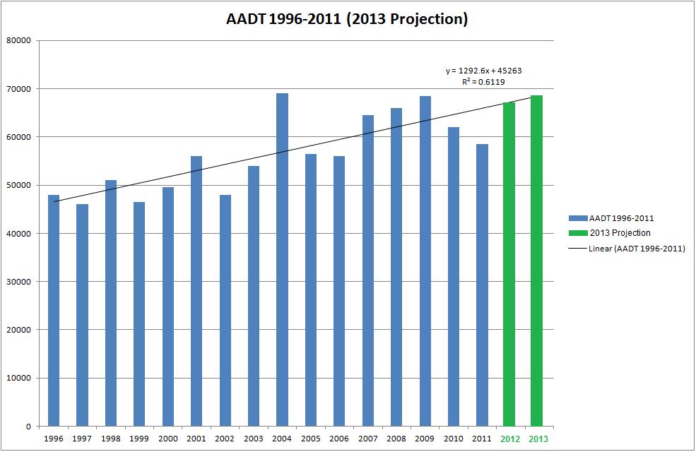
50 FOIDA DEPAMEN OF ANSPOAION ANSPOAION SAISICS OFFICE 211 HISOICA AAD EPO COUNY: 87 - MIAMI-DADE SIE: 9 - S 9/US-41/SW 8 S, 5' E SW 19 AV YEA AAD DIECION 1 DIECION 2 *K FACO D FACO FACO C E 31 W C E 325 W C E 335 W C E 315 W C E 315 W C E 28 W C E 28 W C E 37 W C E 27 W C E 23 W C E 29 W C E 27 W C E 25 W C E 27 W C E 25 W C E 27 W AAD FAGS: C = COMPUED; E = MANUA ESIMAE; F = FIS YEA ESIMAE S = SECOND YEA ESIMAE; = HID YEA ESIMAE; X = UNKNOWN *K FACO: SAING WIH YEA 211 IS SANDADK, PIO YEAS AE K3 VAUES
51 211 PEAK SEASON FACO CAEGOY EPO - EPO YPE: A CAEGOY: 871 MIAMI-DADE SOUH MOCF:.97 WEEK DAES SF PSCF ================================================================================ 1 1/1/211-1/1/ /2/211-1/8/ /9/211-1/15/ /16/211-1/22/ /23/211-1/29/ * 6 1/3/211-2/5/ * 7 2/6/211-2/12/ * 8 2/13/211-2/19/ * 9 2/2/211-2/26/ *1 2/27/211-3/5/ *11 3/6/211-3/12/ *12 3/13/211-3/19/ *13 3/2/211-3/26/ *14 3/27/211-4/2/ *15 4/3/211-4/9/ *16 4/1/211-4/16/ *17 4/17/211-4/23/ *18 4/24/211-4/3/ /1/211-5/7/ /8/211-5/14/ /15/211-5/21/ /22/211-5/28/ /29/211-6/4/ /5/211-6/11/ /12/211-6/18/ /19/211-6/25/ /26/211-7/2/ /3/211-7/9/ /1/211-7/16/ /17/211-7/23/ /24/211-7/3/ /31/211-8/6/ /7/211-8/13/ /14/211-8/2/ /21/211-8/27/ /28/211-9/3/ /4/211-9/1/ /11/211-9/17/ /18/211-9/24/ /25/211-1/1/ /2/211-1/8/ /9/211-1/15/ /16/211-1/22/ /23/211-1/29/ /3/211-11/5/ /6/211-11/12/ /13/211-11/19/ /2/211-11/26/211 11/27/211-12/3/ /4/211-12/1/ /11/211-12/17/ /18/211-12/24/ /25/211-12/31/ * PEAK SEASON 14-FEB :42:32 83UPD [1,,,1] 6_871_PKSEASON.X
52
53 Appendix F 213 (Projected) PM Peak Hour Volumes (MC s) with Intersection Sketches
54
55
56
57
58 Appendix G Existing ane Configuration Diagram at Intersections
59 EXISING ANE CONFIGUAION DIAGAM
60 EXISING ANE CONFIGUAION DIAGAM
61 EXISING ANE CONFIGUAION DIAGAM
62 EXISING ANE CONFIGUAION DIAGAM UNIVESIY DIVE & SW 19H AVENUE
63 Appendix H Intersection Volume Worksheets at Intersections Existing & 213 PM Peak Hour (MC s)
64 Intersection Volume Worksheet SW 112th Avenue & SW 8th Street (PM) Peak Season Correction Factor: Annual Growth Correction Factor: Existing Conditions (PM Peak Hour) NB NB NB EB EB EB EBU WB WB WB 4: : : : OA ADJ PEAK PHF PM Conditions (Scenario 1 & 2) NB NB NB EB EB EB EBU WB WB WB EXIS ADJ PEAK ADD IP OA
65 Intersection Volume Worksheet SW 19th Avenue & SW 8th Street (PM) Peak Season Correction Factor: Annual Growth Correction Factor: Existing Conditions (PM Peak Hour) NB NB NB SB SB SB EB EB EB WB WB WB 4: : : : OA ADJ PEAK PHF PM Conditions (Scenario 1 & 2) NB NB NB SB SB SB EB EB EB WB WB WB EXIS ADJ PEAK ADD IP OA
66 Intersection Volume Worksheet SW 112th Avenue & University Drive (PM) Peak Season Correction Factor: Annual Growth Correction Factor: Existing Conditions (PM Peak Hour) NB NB NB SB SB SB EB EB EB WB WB WB 4: : : : OA ADJ PEAK PHF PM Conditions (Scenario 1 & 2) NB NB NB SB SB SB EB EB EB WB WB WB EXIS ADJ PEAK ADD IP OA
67 Intersection Volume Worksheet SW 19th Avenue & University Drive (PM) Peak Season Correction Factor: Annual Growth Correction Factor: Existing Conditions (PM Peak Hour) SB SB SB EB EB EB WB WB WB 4: : : : OA ADJ PEAK PHF PM Conditions (Scenario 1) SB SB SB EB EB EB WB WB WB EXIS ADJ PEAK ADD IP OA PM Conditions (Scenario 2) SB SB SB EB EB EB WB WB WB EXIS ADJ PEAK ADD IP 7 OA
68 Appendix I 213 PM Peak hour- Projected rip Distributions
69
70 Appendix J Capacity Analysis (HCS 21 Signal) Existing Conditions212 (PM Peak Hour)

 Demand Information EB WB NB SB Approach Movement Demand (v), veh/h 246 474 243 2596 371 37 Signal Information Cycle, s 11.")
, s 5.")
71 HCS 21 Signalized Intersection esults Summary General Information Intersection Information Agency Miami Dade Duration, h.25 Analyst Mo Analysis Date 11/7/212 Area ype Other Jurisdiction ime Period PM Peak PHF.92 Intersection SW 8 Street & SW 112 Ave Analysis Year 212 Analysis Period 1> 16: File Name SW_8_S_and_SW_112_Ave_PM_peak_existing_rev xus Project Description 212 PM Peak Hour (Existing) Demand Information EB WB NB SB Approach Movement Demand (v), veh/h Signal Information Cycle, s 11.5 eference Phase 2 Offset, s eference Point End Uncoordinated Yes Simult. Gap E/W On Force Mode Fixed Simult. Gap N/S On Green Yellow ed imer esults EB EB WB WB NB NB SB SB Assigned Phase Case Number Phase Duration, s Change Period, (Y+c), s Max Allow Headway (MAH), s Queue Clearance ime (gs), s Green Extension ime (ge), s Phase Call Probability Max Out Probability Movement Group esults EB WB NB SB Approach Movement Assigned Movement Adjusted Flow ate (v), veh/h Adjusted Saturation Flow ate (s), veh/h/ln Queue Service ime (gs), s Cycle Queue Clearance ime (gc), s Capacity (c), veh/h Volume-to-Capacity atio (X) Available Capacity (ca), veh/h Back of Queue (Q), veh/ln (5th percentile) Overflow Queue (Q3), veh/ln Queue Storage atio (Q) (5th percentile) Uniform Delay (d1), s/veh Incremental Delay (d2), s/veh Initial Queue Delay (d3), s/veh Control Delay (d), s/veh evel of Service (OS) D C E B E C Approach Delay, s/veh / OS 39.6 D 21.3 C 41.5 D. Intersection Delay, s/veh / OS 31.2 C Multimodal esults EB WB NB SB Pedestrian OS Score / OS 2.3 B.7 A 3.3 C 3.3 C Bicycle OS Score / OS 2. A 2.2 B F Copyright 212 University of Florida, All ights eserved. HCS 21 Streets Version 6.41 Generated: 12/11/212 1:23:59 AM
2.0 Development Driveways. Movin Out June 2017
 Movin Out June 2017 1.0 Introduction The proposed Movin Out development is a mixed use development in the northeast quadrant of the intersection of West Broadway and Fayette Avenue in the City of Madison.
Lacey Gateway Residential Phase 1
 Lacey Gateway Residential Phase Transportation Impact Study April 23, 203 Prepared for: Gateway 850 LLC 5 Lake Bellevue Drive Suite 02 Bellevue, WA 98005 Prepared by: TENW Transportation Engineering West
TRAFFIC SIGNAL DESIGN REPORT KING OF PRUSSIA ROAD & RAIDER ROAD RADNOR TOWNSHIP PENNSYLVANIA
 TRAFFIC SIGNAL DESIGN REPORT KING OF PRUSSIA ROAD & RAIDER ROAD RADNOR TOWNSHIP PENNSYLVANIA PREPARED FOR: UNIVERSITY OF PENNSYLVANIA HEALTH SYSTEM 34 CIVIC CENTER BOULEVARD PHILADELPHIA, PA 1987 (61)
MERIVALE PRIORITY SQUARE 2852 MERIVALE ROAD CITY OF OTTAWA TRANSPORTATION BRIEF. Prepared for: ONT Inc. 25 Winding Way Nepean, Ontario K2C 3H1
 MERIVALE PRIORITY SQUARE 2852 MERIVALE ROAD CITY OF OTTAWA TRANSPORTATION BRIEF Prepared for: 2190986ONT Inc. 25 Winding Way Nepean, Ontario K2C 3H1 October 6, 2010 110-502 Report_1.doc D. J. Halpenny
LAWRENCE TRANSIT CENTER LOCATION ANALYSIS 9 TH STREET & ROCKLEDGE ROAD / 21 ST STREET & IOWA STREET LAWRENCE, KANSAS
 LAWRENCE TRANSIT CENTER LOCATION ANALYSIS 9 TH STREET & ROCKLEDGE ROAD / 21 ST STREET & IOWA STREET LAWRENCE, KANSAS TRAFFIC IMPACT STUDY FEBRUARY 214 OA Project No. 213-542 TABLE OF CONTENTS 1. INTRODUCTION...
MEMO VIA . Ms. Amy Roth DPS Director, City of Three Rivers. To:
 MEMO To: Ms. Amy Roth DPS Director, City of Three Rivers VIA EMAIL From: Michael J. Labadie, PE Julie M. Kroll, PE, PTOE Brandon Hayes, PE, P.Eng. Fleis & VandenBrink Date: January 5, 2017 Re: Proposed
Traffic Impact Analysis West Street Garden Plots Improvements and DuPage River Park Garden Plots Development Naperville, Illinois
 Traffic Impact Analysis West Street Garden Plots Improvements and DuPage River Park Garden Plots Development Naperville, Illinois Submitted by April 9, 2009 Introduction Kenig, Lindgren, O Hara, Aboona,
King Soopers #116 Thornton, Colorado
 Traffic Impact Study King Soopers #116 Thornton, Colorado Prepared for: Galloway & Company, Inc. T R A F F I C I M P A C T S T U D Y King Soopers #116 Thornton, Colorado Prepared for Galloway & Company
Traffic Analysis for Bon Air Bridge Mitigation Magnolia Storm Water Quality Project
 Memo To: Paul DiDonato, ATI Architects and Engineers From: David Parisi, PE and Ashley Tam, EIT Date: February 23, 216 Subject: Traffic Analysis for Bon Air Bridge Mitigation Magnolia Storm Water Quality
EXECUTIVE SUMMARY. The following is an outline of the traffic analysis performed by Hales Engineering for the traffic conditions of this project.
 EXECUTIVE SUMMARY This study addresses the traffic impacts associated with the proposed Shopko redevelopment located in Sugarhouse, Utah. The Shopko redevelopment project is located between 1300 East and
TRAFFIC IMPACT STUDY DERRY GREEN CORPORATE BUSINESS PARK MILTON SECONDARY PLAN MODIFICATION
 TRAFFIC IMPACT STUDY DERRY GREEN CORPORATE BUSINESS PARK MILTON SECONDARY PLAN MODIFICATION TRAFFIC IMPACT STUDY DERRY GREEN CORPORATE BUSINESS PARK MILTON SECONDARY PLAN MODIFICATION DECEMBER 24 UPDATED
BARRHAVEN FELLOWSHIP CRC 3058 JOCKVALE ROAD OTTAWA, ONTARIO TRANSPORTATION BRIEF. Prepared for:
 BARRHAVEN FELLOWSHIP CRC 3058 JOCKVALE ROAD OTTAWA, ONTARIO TRANSPORTATION BRIEF Prepared for: Barrhaven Fellowship CRC 3058 Jockvale Road Ottawa, ON K2J 2W7 December 7, 2016 116-649 Report_1.doc D. J.
Proposed Inn at Bellefield Traffic Impact Assessment
 Proposed Inn at Bellefield Traffic Impact Assessment Town of Hyde Park Dutchess County, New York Prepared for: T-Rex Hyde Park Owner LLC 500 Mamroneck Avenue, Suite 300 Harrison, NY 10528 June 21, 2017
APPENDIX C1 TRAFFIC ANALYSIS DESIGN YEAR TRAFFIC ANALYSIS
 APPENDIX C1 TRAFFIC ANALYSIS DESIGN YEAR TRAFFIC ANALYSIS DESIGN YEAR TRAFFIC ANALYSIS February 2018 Highway & Bridge Project PIN 6754.12 Route 13 Connector Road Chemung County February 2018 Appendix
Transportation & Traffic Engineering
 Transportation & Traffic Engineering 1) Project Description This report presents a summary of findings for a Traffic Impact Analysis (TIA) performed by A+ Engineering, Inc. for the Hill Country Family
APPENDIX E. Traffic Analysis Report
 APPENDIX E Traffic Analysis Report THIS PAGE INTENTIONALLY BLANK EAGLE RIVER TRAFFIC MITIGATION PHASE I OLD GLENN HIGHWAY/EAGLE RIVER ROAD INTERSECTION IMPROVEMENTS TRAFFIC ANALYSIS Eagle River, Alaska
Traffic Impact Statement (TIS)
") Traffic Impact Statement (TIS) Vincentian PUDA Collier County, FL 10/18/2013 Prepared for: Global Properties of Naples Prepared by: Trebilcock Consulting Solutions, PA 2614 Tamiami Trail N, Suite 615 1205
Traffic Impact Statement (TIS) Vincentian PUDA Collier County, FL 10/18/2013 Prepared for: Global Properties of Naples Prepared by: Trebilcock Consulting Solutions, PA 2614 Tamiami Trail N, Suite 615 1205
Appendix C-5: Proposed Refinements Rail Operations and Maintenance Facility (ROMF) Traffic Impact Analysis. Durham-Orange Light Rail Transit Project
 Traffic Impact Analysis. Durham-Orange Light Rail Transit Project") Appendix C-5: Proposed Refinements Rail Operations and Maintenance Facility (ROMF) Traffic Impact Analysis Durham-Orange Light Rail Transit Project July 25, 218 ROMF Transportation Impact Analysis Version
Appendix C-5: Proposed Refinements Rail Operations and Maintenance Facility (ROMF) Traffic Impact Analysis Durham-Orange Light Rail Transit Project July 25, 218 ROMF Transportation Impact Analysis Version
APPENDIX B Traffic Analysis
 APPENDIX B Traffic Analysis Rim of the World Unified School District Reconfiguration Prepared for: Rim of the World School District 27315 North Bay Road, Blue Jay, CA 92317 Prepared by: 400 Oceangate,
Traffic Impact Study Speedway Gas Station Redevelopment
 Traffic Impact Study Speedway Gas Station Redevelopment Warrenville, Illinois Prepared For: Prepared By: April 11, 2018 Table of Contents 1. Introduction... 1 2. Existing Conditions... 4 Site Location...
Traffic Impact Analysis. Alliance Cole Avenue Residential Site Dallas, Texas. Kimley-Horn and Associates, Inc. Dallas, Texas.
 Traffic Impact Analysis Alliance Cole Avenue Residential Site Dallas, Texas February 15, 2018 Kimley-Horn and Associates, Inc. Dallas, Texas Project #064524900 Registered Firm F-928 Traffic Impact Analysis
TRAFFIC IMPACT STUDY FOR SONIC DRIVE-IN RESTAURANT. Vallejo, CA. Prepared For:
 TRAFFIC IMPACT STUDY FOR SONIC DRIVE-IN RESTAURANT Vallejo, CA Prepared For: ELITE DRIVE-INS, INC. 2190 Meridian Park Blvd, Suite G Concord, CA 94520 Prepared By: KD Anderson & Associates 3853 Taylor Road,
DEVELOPMENT PROPERTY 1627 MAXIME STREET CITY OF OTTAWA TRANSPORTATION OVERVIEW. Prepared for: Subhas Bhargava. July 9, Overview_1.
 DEVELOPMENT PROPERTY 1627 MAXIME STREET CITY OF OTTAWA TRANSPORTATION OVERVIEW Prepared for: Subhas Bhargava July 9, 2015 115-620 Overview_1.doc D. J. Halpenny & Associates Ltd. Consulting Transportation
Traffic Impact Study for the proposed. Town of Allegany, New York. August Project No Prepared For:
 Appendix B SRF Traffic Study (Revised November 2005) Draft Environmental Impact Statement University Commons Town of Allegany, Cattaraugus County, NY December 2005 Traffic Impact Study for the proposed
Roundabout Feasibility Study SR 44 at Grand Avenue TABLE OF CONTENTS
 Roundabout Feasibility Study SR 44 at Grand Avenue TABLE OF CONTENTS Introduction and Executive Summary... 1 Existing Conditions... 3 Intersection Volume Conditions... 5 Intersection Operations... 9 Safety
Kansas City Missouri Public Works 414 East 12th Street Kansas City, Mo
 Page No : 1 Groups Printed- Unshifted Southbound Westbound Northbound Eastbound Start Time Peds App. Total Peds App. Total Peds App. Total Peds App. Total Exclu. Total Inclu. Total Int. Total 07:00 AM
Traffic Engineering Study
 Traffic Engineering Study Bellaire Boulevard Prepared For: International Management District Technical Services, Inc. Texas Registered Engineering Firm F-3580 November 2009 Executive Summary has been requested
Oakbrook Village Plaza City of Laguna Hills
 Oakbrook Village Plaza City of Laguna Hills Traffic Impact Analysis Prepared by: HDR Engineering 3230 El Camino Real, Suite 200 Irvine, CA 92602 October 2012 Revision 3 D-1 Oakbrook Village Plaza Laguna
Existing Traffic Conditions
 May 14, 2014 Ms. Lorraine Weiss City of San Mateo 330 West 20 th Avenue San Mateo, CA 94403 Subject: Traffic Operational Study for the Proposed Tilton Avenue Residential Development in San Mateo, California
Bennett Pit. Traffic Impact Study. J&T Consulting, Inc. Weld County, Colorado. March 3, 2017
 Bennett Pit Traffic Impact Study J&T Consulting, Inc. Weld County, Colorado March 3, 217 Prepared By: Sustainable Traffic Solutions, Inc. http://www.sustainabletrafficsolutions.com/ Joseph L. Henderson,
Clean Harbors Canada, Inc.
 Clean Harbors Canada, Inc. Proposed Lambton Landfill Expansion Environmental Assessment Terms of Reference Transportation Assessment St. Clair Township, Ontario September 2009 itrans Consulting Inc. 260
TRAFFIC IMPACT ANALYSIS FOR THE 630/650 SOUTH STREET RETAIL DEVELOPMENT WRENTHAM, MASSACHUSETTS
 PARE PROJECT NO. 17120.00 REPORT TRAFFIC IMPACT ANALYSIS FOR THE 630/650 SOUTH STREET RETAIL DEVELOPMENT WRENTHAM, MASSACHUSETTS SUBMITTED TO: GEORGETOWN CAPITAL MANAGEMENT PO BOX 369 GEORGETOWN, MA 01833
Section 5.0 Traffic Information
 Section 5.0 Traffic Information 10.0 TRANSPORTATION MDM Transportation Consultants, Inc. (MDM) has prepared an evaluation of transportation impacts for the proposed evaluation for the expansion of the
INDUSTRIAL DEVELOPMENT
 INDUSTRIAL DEVELOPMENT Traffic Impact Study Plainfield, Illinois August 2018 Prepared for: Seefried Industrial Properties, Inc. TABLE OF CONTENTS Executive Summary 2 Introduction 3 Existing Conditions
INTERSECTION ANALYSIS PARK AVENUE AND BRADDOCK ROAD (FROSTBURG, MD) FOR LENHART TRAFFIC CONSULTING, INC.
 FOR LENHART TRAFFIC CONSULTING, INC.") INTERSECTION ANALYSIS FOR PARK AVENUE AND BRADDOCK ROAD (FROSTBURG, MD) Prepared for: City of Frostburg, Maryland & Allegany County Commissioners Prepared by: LENHART TRAFFIC CONSULTING, INC. TRAFFIC ENGINEERING
INTERSECTION ANALYSIS FOR PARK AVENUE AND BRADDOCK ROAD (FROSTBURG, MD) Prepared for: City of Frostburg, Maryland & Allegany County Commissioners Prepared by: LENHART TRAFFIC CONSULTING, INC. TRAFFIC ENGINEERING
105 Toronto Street South, Markdale Transportation Impact Study. Paradigm Transportation Solutions Limited
 105 Toronto Street South, Markdale Transportation Impact Study Paradigm Transportation Solutions Limited December 2016 Project Summary Project Number 162060 December 2016 Client Zelinka Priamo Ltd 318
TRAFFIC IMPACT STUDY. USD #497 Warehouse and Bus Site
 TRAFFIC IMPACT STUDY for USD #497 Warehouse and Bus Site Prepared by: Jason Hoskinson, PE, PTOE BG Project No. 16-12L July 8, 216 145 Wakarusa Drive Lawrence, Kansas 6649 T: 785.749.4474 F: 785.749.734
TRAFFIC IMPACT ANALYSIS
 TRAFFIC IMPACT ANALYSIS Emerald Isle Commercial Development Prepared by SEPI Engineering & Construction Prepared for Ark Consulting Group, PLLC March 2016 I. Executive Summary A. Site Location The Emerald
RICHMOND OAKS HEALTH CENTRE 6265 PERTH STREET OTTAWA, ONTARIO TRANSPORTATION BRIEF. Prepared for: Guycoki (Eastern) Limited.
 Limited.") RICHMOND OAKS HEALTH CENTRE 6265 PERTH STREET OTTAWA, ONTARIO TRANSPORTATION BRIEF Prepared for: Guycoki (Eastern) Limited June 16, 2016 116-638 Brief_1.doc D. J. Halpenny & Associates Ltd. Consulting
RICHMOND OAKS HEALTH CENTRE 6265 PERTH STREET OTTAWA, ONTARIO TRANSPORTATION BRIEF Prepared for: Guycoki (Eastern) Limited June 16, 2016 116-638 Brief_1.doc D. J. Halpenny & Associates Ltd. Consulting
Escondido Marriott Hotel and Mixed-Use Condominium Project TRAFFIC IMPACT ANALYSIS REPORT
 Escondido Marriott Hotel and Mixed-Use Condominium Project TRAFFIC IMPACT ANALYSIS REPORT Prepared for Phelps Program Management 420 Sixth Avenue, Greeley, CO 80632 Prepared by 5050 Avenida Encinas, Suite
West Hills Shopping Centre Lowe s Expansion Traffic Impact Study
 West Hills Shopping Centre Lowe s Expansion Traffic Impact Study Prepared for: Armel Corporation January 2015 Paradigm Transportation Solutions Ltd. 22 King Street South, Suite 300 Waterloo ON N2J 1N8
DRAFT TRANSPORTATION IMPACT STUDY CASTILIAN REDEVELOPMENT PROJECT
 DRAFT TRANSPORTATION IMPACT STUDY CASTILIAN REDEVELOPMENT PROJECT Prepared for: Submitted by: 299 Lava Ridge Ct. Suite 2 Roseville, CA. 95661 June 212 TABLE OF CONTENTS 1. Introduction... 1 Project Location
Craig Scheffler, P.E., PTOE HNTB North Carolina, P.C. HNTB Project File: Subject
 TECHNICAL MEMORANDUM To Kumar Neppalli Traffic Engineering Manager Town of Chapel Hill From Craig Scheffler, P.E., PTOE HNTB North Carolina, P.C. Cc HNTB Project File: 38435 Subject Obey Creek TIS 2022
Table of Contents. Traffic Impact Analysis Capital One Building at Schilling Place
 Traffic Impact Analysis Capital One Building at Schilling Place Table of Contents Executive Summary... 1 1. Introduction... 4 2. Project Description... 4 3. Background Information... 4 4. Study Scope...
V. DEVELOPMENT OF CONCEPTS
 Martin Luther King, Jr. Drive Extension FINAL Feasibility Study Page 9 V. DEVELOPMENT OF CONCEPTS Throughout the study process several alternative alignments were developed and eliminated. Initial discussion
Transit City Etobicoke - Finch West LRT
 Delcan Corporation Transit City Etobicoke - Finch West LRT APPENDIX D Microsimulation Traffic Modeling Report March 2010 March 2010 Appendix D CONTENTS 1.0 STUDY CONTEXT... 2 Figure 1 Study Limits... 2
Volume 1 Traffic Impact Analysis Turtle Creek Boulevard Dallas, Texas. Kimley-Horn and Associates, Inc. Dallas, Texas.
 Volume 1 Traffic Impact Analysis 2727 Dallas, Texas June 18, 2018 Kimley-Horn and Associates, Inc. Dallas, Texas Project #064523000 Registered Firm F-928 Traffic Impact Analysis 2727 Dallas, Texas Prepared
4.14 TRANSPORTATION AND CIRCULATION
 4.14 TRANSPORTATION AND CIRCULATION 4.14.1 Summary Table 4.14-1 summarizes the identified environmental impacts, proposed mitigation measures, and residual impacts of the proposed project with regard to
Proposed location of Camp Parkway Commerce Center. Vicinity map of Camp Parkway Commerce Center Southampton County, VA
 Proposed location of Camp Parkway Commerce Center Vicinity map of Camp Parkway Commerce Center Southampton County, VA Camp Parkway Commerce Center is a proposed distribution and industrial center to be
TRAFFIC DATA. Existing Derousse Ave./River Rd. AM LOS Analysis Existing Derousse Ave./River Rd. PM LOS Analysis
 Appendix E NJ TRANSIT Pennsauken Junction Transit Center and Park & Ride RiverLINE and Atlantic City Line Pennsauken Township, Camden County, New Jersey TRAFFIC DATA Background Traffic Information for
To: File From: Adrian Soo, P. Eng. Markham, ON File: Date: August 18, 2015
 Memo To: From: Adrian Soo, P. Eng. Markham, ON : 165620021 Date: Reference: E.C. Row Expressway, Dominion Boulevard Interchange, Dougall Avenue Interchange, and Howard 1. Review of Interchange Geometry
MILLERSVILLE PARK TRAFFIC IMPACT ANALYSIS ANNE ARUNDEL COUNTY, MARYLAND
 MILLERSVILLE PARK TRAFFIC IMPACT ANALYSIS ANNE ARUNDEL COUNTY, MARYLAND Prepared for: Department of Public Works Anne Arundel County Prepared by: URS Corporation 4 North Park Drive, Suite 3 Hunt Valley,
APPENDIX C-2. Traffic Study Supplemental Analysis Memo
 APPENDIX C-2 Traffic Study Supplemental Analysis Memo The Mobility Group Transportation Strategies & Solutions Memorandum To: From: Subject: Tomas Carranza, LADOT Matthew Simons Traffic Review - Revised
TRAFFIC IMPACT STUDY FOR ST. JOSEPH'S ELEMENTARY SCHOOL ADDITION
 CATHOLIC DISTRICT SCHOOL BOARD OF EASTERN ONTARIO P.O. 61992 TRAFFIC IMPACT STUDY FOR ST. JOSEPH'S ELEMENTARY SCHOOL ADDITION SEPTEMBER 5, 218 TRAFFIC IMPACT STUDY FOR ST. JOSEPH'S ELEMENTARY SCHOOL ADDITION
TABLE OF CONTENTS 1.0 INTRODUCTION AND SUMMARY Purpose of Report and Study Objectives... 2
 TABLE OF CONTENTS 1.0 INTRODUCTION AND SUMMARY 1 1.1 Purpose of Report and Study Objectives... 2 1.2 Executive Summary... 3 1.2.1 Site Location and Study Area... 3 1.2.2 Development Description... 3 1.2.3
County State Aid Highway 30 (Diffley Road) and Dodd Road Intersection Study
 and Dodd Road Intersection Study") County State Aid Highway 30 (Diffley Road) and Dodd Road Intersection Study City of Eagan, Dakota County, Minnesota Date: March 2012 Project No. 14957.000 444 Cedar Street, Suite 1500 Saint Paul, MN 55101
County State Aid Highway 30 (Diffley Road) and Dodd Road Intersection Study City of Eagan, Dakota County, Minnesota Date: March 2012 Project No. 14957.000 444 Cedar Street, Suite 1500 Saint Paul, MN 55101
Date: February 7, 2017 John Doyle, Z-Best Products Robert Del Rio. T.E. Z-Best Traffic Operations and Site Access Analysis
 Memorandum Date: February 7, 07 To: From: Subject: John Doyle, Z-Best Products Robert Del Rio. T.E. Z-Best Traffic Operations and Site Access Analysis Introduction Hexagon Transportation Consultants, Inc.
L1TILE BEARS DAY CARE TRANSPORTATION IMPACT STUDY FORT COLLINS, COLORADO MAY Prepared for:
 L1TILE BEARS DAY CARE TRANSPORTATION IMPACT STUDY FORT COLLINS, COLORADO MAY 2012 Prepared for: Hillside Construction, Inc. 216 Hemlock Street, Suite B Fort Collins, CO 80534 Prepared by: DELICH ASSOCIATES
INTERSECTION CONTROL EVALUATION
 INTERSECTION CONTROL EVALUATION Trunk Highway 22 and CSAH 21 (E Hill Street/Shanaska Creek Road) Kasota, Le Sueur County, Minnesota November 2018 Trunk Highway 22 and Le Sueur CSAH 21 (E Hill Street/Shanaska
NEWCASTLE MIDDLE SCHOOL Traffic Impact Analysis
 Gibson Traffic Consultants 2802 Wetmore Avenue Suite 220 Everett, WA 98201 425.339.8266 NEWCASTLE MIDDLE SCHOOL Traffic Impact Analysis Prepared for: Renton School District Jurisdiction: City of Newcastle
Downtown One Way Street Conversion Technical Feasibility Report
 Downtown One Way Street Conversion Technical Feasibility Report As part of the City s Transportation Master Plan, this report reviews the technical feasibility of the proposed conversion of the current
D & B COMMERCIAL TRAFFIC IMPACT ANALYSIS
 D & B COMMERCIAL TRAFFIC IMPACT ANALYSIS TABLE OF CONTENTS I. Introduction...3 II. Project Description...3 III. Existing Conditions...3 IV. Future Traffic Conditions...8 V. Conclusions and Mitigation...14
IV. ENVIRONMENTAL IMPACT ANALYSIS J. TRANSPORTATION AND TRAFFIC
 IV. ENVIRONMENTAL IMPACT ANALYSIS J. TRANSPORTATION AND TRAFFIC This Section summarizes the information provided in the Traffic Study for the Santa Monica College Bundy Campus Master Plan (Traffic Study),
One Harbor Point Residential
 Residential Gig Harbor, WA Transportation Impact Analysis January 23, 2017 Prepared for: Neil Walter Company PO Box 2181 Tacoma, WA 98401 Prepared by: TENW Transportation Engineering NorthWest 11400 SE
TRAFFIC IMPACT ANALYSIS FOR. McDONALD S RESTAURANT IN CARMICAEL Sacramento County, CA. Prepared For:
 TRAFFIC IMPACT ANALYSIS FOR McDONALD S RESTAURANT IN CARMICAEL Sacramento County, CA Prepared For: McDonald s USA, LLC Pacific Sierra Region 2999 Oak Road, Suite 900 Walnut Creek, CA 94597 Prepared By:
TIMBERVINE TRANSPORTATION IMPACT STUDY FORT COLLINS, COLORADO JANUARY Prepared for:
 TIMBERVINE TRANSPORTATION IMPACT STUDY FORT COLLINS, COLORADO JANUARY 2014 Prepared for: Hartford Companies 1218 W. Ash Street Suite A Windsor, Co 80550 Prepared by: DELICH ASSOCIATES 2272 Glen Haven Drive
PROJECT: Wilkinson Road Corridor Improvement Traffic Management Planning Project SUBJECT: Traffic Analysis
 TECHNICAL MEMORANDUM DATE: September 10, 2014 PROJECT 5861.03 NO: PROJECT: Wilkinson Road Corridor Improvement Traffic Management Planning Project SUBJECT: Traffic Analysis TO: Steve Holroyd - District
IV. REVISIONS TO THE DRAFT IS/MND
 IV. REVISIONS TO THE DRAFT IS/MND 1. REVISIONS TO THE DRAFT IS/MND This section presents corrections and clarifications that have been made to the text of the Draft IS/MND. These changes include revisions
Traffic Impact Analysis for 2171 Rosecrans Avenue
 Traffic Impact Analysis for 2171 Rosecrans Avenue Prepared for: Continental Development Corporation Revised May 2016 LA16-2831 Prepared by: Fehr & Peers 600 Wilshire Blvd, Suite 1050 Los Angeles, CA 90017
Memorandum. To: Sue Polka, City Engineer, City of Arden Hills. From: Sean Delmore, PE, PTOE. Date: June 21, 2017
 Memorandum engineering planning environmental construction 701 Xenia Avenue South Suite 300 Minneapolis, MN 55416 Tel: 763-541-4800 Fax: 763-541-1700 To: Sue Polka, City Engineer, City of Arden Hills From:
GASOLINE SERVICE STATION 1618, 1622 ROGER STEVENS DRIVE OTTAWA, ONTARIO TRANSPORTATION IMPACT ASSESSMENT. Prepared for:
 GASOLINE SERVICE STATION 1618, 1622 ROGER STEVENS DRIVE OTTAWA, ONTARIO TRANSPORTATION IMPACT ASSESSMENT Prepared for: Invecta Development (Ottawa) Corporation 758 Shanks Height Milton, ON L9T 7P7 May
Traffic Impact Study Hudson Street Parking Garage MC Project No.: A Table of Contents
 Traffic Impact Study Hudson Street Parking Garage MC Project No.: 15001714A Table of Contents Table of Contents I. INTRODUCTION... 1 II. EXISTING CONDITIONS... 4 III. 2015 EXISTING TRAFFIC CONDITIONS...
December 5, Red Bank Planning Board Municipal Building 90 Monmouth Street Red Bank, NJ 07701
 Dynamic Traffic, LLC www.dynamic-traffic.com 1904 Main Street Lake Como, NJ 07719 T. 732.681.0760 December 5, 2016 Red Bank Planning Board Municipal Building 90 Monmouth Street Red Bank, NJ 07701 Re: Traffic
EXECUTIVE SUMMARY. The valet operation, service area, and drop-off lanes provided will be adequate Page i
 EXECUTIVE SUMMARY MacKenzie Engineering and Planning, Inc. performed an analysis of the traffic impacts resulting from the proposed project site located at 25 SE 4th Avenue, Delray Beach, Florida (PCN
LATSON INTERCHANGE DEVELOPMENT TRAFFIC STUDIES. Genoa Township, Livingston County, MI
 LATSON INTERCHANGE DEVELOPMENT TRAFFIC STUDIES Genoa Township, Livingston County, MI DRAFT TRAFFIC STUDY FOR I-96 AT LATSON RD INTERCHANGE Livingston County CS 47065 JN 101622C Submitted to: Michigan Department
County State Aid Highway 32 (Cliff Road) and Dodd Road Intersection Study
 and Dodd Road Intersection Study") County State Aid Highway 32 (Cliff Road) and Dodd Road Intersection Study City of Eagan, Dakota County, Minnesota Date: March 2012 Project No. 14957.000 444 Cedar Street, Suite 1500 Saint Paul, MN 55101
County State Aid Highway 32 (Cliff Road) and Dodd Road Intersection Study City of Eagan, Dakota County, Minnesota Date: March 2012 Project No. 14957.000 444 Cedar Street, Suite 1500 Saint Paul, MN 55101
Shirk Road at State Route 198 Interchange Analysis Tulare County, California
 Shirk Road at State Route 198 Interchange Analysis Tulare County, California DRAFT REPORT Prepared By Tulare County Association of Governments (TCAG) April 2013 Table of Contents Introduction:... 3 Project
Ingraham High School Parking and Traffic Analysis
 Parking and Traffic Analysis Seattle, WA Prepared for: URS Corporation 1501 4th Avenue, Suite 1400 Seattle, WA 98101-1616 Mirai Transportation Planning & Engineering 11410 NE 122nd Way, Suite 320 Kirkland,
RTE. 1 at RTE. 637 & RTE. 639
 INTERSECTION SAFETY STUDY Prepared for: Virginia Department of Transportation Central Region Operations Traffic Engineering (UPC #81378, TO 12-092) DAVENPORT Project Number: 13-368 / /2014 RTE. 1 at RTE.
BERKELEY DOWNTOWN AREA PLAN PROGRAM ENVIRONMENTAL IMPACT REPORT TRAFFIC IMPACT ANALYSIS
 BERKELEY DOWNTOWN AREA PLAN PROGRAM ENVIRONMENTAL IMPACT REPORT TRAFFIC IMPACT ANALYSIS Prepared for: City of Berkeley Prepared by: REVISED JANUARY 9, 2009 Berkeley Downtown Area Plan Program EIR Traffic
Traffic Assessment SUNY Buffalo School of Medicine & Biomedical Sciences TRAFFIC ASSESSMENT
 TRAFFIC ASSESSMENT University at Buffalo School of Medicine & Biomedical Sciences Buffalo Niagara Medical Campus Buffalo, NY Prepared for: State University Construction Fund 353 Broadway Albany, New York
Traffic Impact Analysis Update
 Willow Bend Traffic Impact Analysis Update TABLE OF CONTENTS Page I. INTRODUCTION -------------------------------------------------------------------------------------------- 1 II. EXISTING CONDITIONS
TRAFFIC IMPACT ANALYSIS SHORTBREAD LOFTS 2009 MODIFICATION Chapel Hill, North Carolina
 TRAFFIC IMPACT ANALYSIS SHORTBREAD LOFTS 2009 MODIFICATION Chapel Hill, North Carolina Prepared for: The Town of Chapel Hill, NC Prepared by: Architects-Engineers-Planners, Inc. November 2009 Traffic Impact
MEMORANDUM. Figure 1. Roundabout Interchange under Alternative D
 MEMORANDUM Date: To: Liz Diamond, Dokken Engineering From: Subject: Dave Stanek, Fehr & Peers Western Placerville Interchanges 2045 Analysis RS08-2639 Fehr & Peers has completed a transportation analysis
King County Metro. Columbia Street Transit Priority Improvements Alternative Analysis. Downtown Southend Transit Study. May 2014.
 King County Metro Columbia Street Transit Priority Improvements Alternative Analysis Downtown Southend Transit Study May 2014 Parametrix Table of Contents Introduction... 1 Methodology... 1 Study Area...
INTERCHANGE OPERTIONS STUDY Interstate 77 / Wallings Road Interchange
 INTERCHANGE OPERTIONS STUDY Interstate 77 / Wallings Road Interchange City of Broadview Heights, Cuyahoga County, Ohio Prepared For: City of Broadview Heights Department of Engineering 9543 Broadview Road
Vanier Parkway and Presland Road Residential Development Transportation Impact Study
 Vanier Parkway and Presland Road Residential Development Transportation Impact Study Final Report (Revised) March 2011 Submitted to: Groupe Lépine Ottawa Project No. 09-1613 Submitted by: Groupe Lépine
BROWARD BOULEVARD CORRIDOR TRANSIT STUDY
 BROWARD BOULEVARD CORRIDOR TRANSIT STUDY FM # 42802411201 EXECUTIVE SUMMARY July 2012 GOBROWARD Broward Boulevard Corridor Transit Study FM # 42802411201 Executive Summary Prepared For: Ms. Khalilah Ffrench,
TRANSPORTATION TECHNICAL REPORT
 TRANSPORTATION TECHNICAL REPORT for Sunrise Elementary School Replacement PREPARED FOR: Puyallup School District PREPARED BY: 6544 NE 61 st Street, Seattle, WA 98115 ph: (26) 523-3939 fx: (26) 523-4949
MINERVA PARK SITE TRAFFIC IMPACT STUDY M/I HOMES. September 2, 2015
 5500 New Albany Road Columbus, Ohio 43054 Phone: 614.775.4500 Fax: 614.775.4800 Toll Free: 1-888-775-EMHT emht.com 2015-1008 MINERVA PARK SITE TRAFFIC IMPACT STUDY M/I HOMES September 2, 2015 Engineers
Traffic Impact Study for Proposed Olive Boulevard Development
 Traffic Impact Study for Proposed 11330 Olive Boulevard Development Creve Coeur, Missouri July 7, 2017 Prepared For: 11330 Olive Boulevard Development 11330 Olive Boulevard Creve Coeur, Missouri 63141
Proposed CVS/pharmacy
 Traffic Impact and Access Study Proposed CVS/pharmacy West Main Street (Route 1) at Hull Street Clinton, Connecticut PREPARED FOR Arista Development LLC 520 Providence Highway, Suite 9 Norwood, Massachusetts
Trafalgar Road & Lower Base Line Transportation Study Ontario Inc.
 Trafalgar Road & Lower Base Line Transportation Study 1255723 Ontario Inc. Trafalgar Road & Lower Base Line Transportation Study 1255723 Ontario Inc. 1465 Pickering Parkway Suite 200 Pickering ON L1V 7G7
MURRIETA APARTMENTS TRAFFIC IMPACT ANALYSIS CITY OF MURRIETA, CALIFORNIA
 MURRIETA APARTMENTS TRAFFIC IMPACT ANALYSIS CITY OF MURRIETA, CALIFORNIA SEPTEMBER 20, 2012 Prepared for: Golden Eagle Multi-Family Properties, LLC 6201 Oak Canyon Rd., Suite 250 Irvine, CA 92618 Prepared
TRANSPORTATION REVIEW
 TRANSPORTATION REVIEW - PROPOSED MIX OF LAND USES IS CONSISTENT WITH THE CITY S UNDER THE GRANVILLE BRIDGE POLICIES THAT AIM TO MEET NEIGHBOURING RESIDENTS SHOPPING NEEDS AND REDUCE RELIANCE ON AUTOMOBILE
Submittal Document II.G. D-bar-A Project, Traffic Impact Study, prepared by Bergmman Associates, dated November 3, 2015 ( Traffic Study )
") Submittal Document II.G. D-bar-A Project, Traffic Impact Study, prepared by Bergmman Associates, dated November 3, 2015 ( Traffic Study ) D-bar-A Project Traffic Impact Study November 3 rd, 2015 1427
Submittal Document II.G. D-bar-A Project, Traffic Impact Study, prepared by Bergmman Associates, dated November 3, 2015 ( Traffic Study ) D-bar-A Project Traffic Impact Study November 3 rd, 2015 1427
KUM & GO 6400 WESTOWN PARKWAY WEST DES MOINES, IOWA 50266
 KUM & GO #300 PECOS STREET & 88 TH AVENUE THORNTON, COLORADO TRAFFIC IMPACT STUDY REVISION 1 PREPARED FOR KUM & GO 6400 WESTOWN PARKWAY WEST DES MOINES, IOWA 50266 JANUARY 23, 2014 OA PROJECT NO. 013-1721
Traffic Feasibility Study
 Traffic Feasibility Study Town Center South Robbinsville Township, Mercer County, New Jersey December 19, 2017 Prepared For Robbinsville Township Department of Community Development 2298 Route 33 Robbinsville,
Interstate Operations Study: Fargo-Moorhead Metropolitan Area Simulation Results
 NDSU Dept #2880 PO Box 6050 Fargo, ND 58108-6050 Tel 701-231-8058 Fax 701-231-6265 www.ugpti.org www.atacenter.org Interstate Operations Study: Fargo-Moorhead Metropolitan Area 2025 Simulation Results
Appendix H: Construction Impacts H-2 Transportation
 Appendix H: Construction Impacts H-2 Transportation \ AECOM 71 W. 23 rd Street New York, NY 10010 www.aecom.com 212 366 6200 tel 212 366 6214 fax Memorandum To CC Subject Robert Conway Donald Tone Construction