Wellington West Local Area Parking Study
|
|
|
- Kevin White
- 6 years ago
- Views:
Transcription
1 Wellington West Local Area Parking Study Parking Services Public Works Department City of Ottawa March 207
2 Table of Contents Section Heading Page Number Background 4. Study Purpose 4.2 Study Area 6.3 Definitions.4 Types of Parking 2.5 Previous Parking Studies 4 2 Overview of Existing and Future Conditions 6 2. Uses and Land Use City of Ottawa Official Plan Development Potential for Wellington West Development Applications Summary of Reductions in Parking City of Ottawa Zoning By-law Population & Employment Forecasts Mode Split for Trips Destines to Wellington West 28 3 Methodology and Data Collection Total Parking Inventory Parking Occupancy Methodology Total Parking Inventory Parking Occupancy Methodology Parking Data Results Parking Duration Methodology Parking Enforcement Bicycle Parking Bicycle Parking Supply Bicycle Parking Occupancy Travel Surveys Results from Patrons Results from Employees 49 4 Public Consultation 5 5 Analysis Wellington Street West / Somerset Street West Occupancy Findings for Wellington Street West / Somerset Street West On-Street Parking Demographics Comparisons 62 6 Side Street Parking 65 7 Parking Duration 68 8 Off-Street Parking 7 8. Occupancy for Lot Holland Cross 72 2
3 9 Parking Toolbox Overview 75 Bicycle Parking 76 Transit Service 76 Measures to Reduce Employee Parking Demand 77 Car-sharing / Car-pooling Promotion 78 Municipal Parking Lot Supply 79 Curb-Side Street Parking Supply 80 Agreements with Developers 80 Zoning Provision Adjustments 8 Curb-Side Parking Regulations 82 Enforcement Levels 84 Parking Price Adjustments 85 Off-Street Parking Visibility / Promotion 88 0 Recommendations Recommendations 89 Appendix - Development Applications within Wellington West 9 Appendix 2 Parking Occupancy Maps 99 Appendix 3 Licence Plate Survey Routes 4 Appendix 4 Parking Duration 6 Appendix 5 Travel Survey Questionnaire 25 Appendix 6 Travel Survey Results 28 Appendix 7 - Public Consultation (Feedback / Comments) 40 3
4 Section - Background. Study Purpose The Local Area Parking Study (LAPS) for Wellington West was initiated in 205 by the Parking Services Branch of the City of Ottawa. Wellington West is an area that has experienced, and has high potential for, development and intensification. Despite all of the growth within the study area, there have been limited previous parking studies conducted for Wellington West. The LAPS is being conducted in conjunction with an update to a previous Westboro LAPS. In response, City staff have undertaken data collection and consultation in both areas towards completing a full Local Area Parking Study for Wellington West and a Local Area Parking Study Update for Westboro. The findings from these studies will be implemented as the Kitchissippi Parking Strategy. The Wellington West LAPS represents the ninth Local Area Parking Study (LAPS) to be completed since the approval of the Municipal Parking Management Strategy (MPMS) in Previous studies include ByWard Market, Glebe, Westboro, Little Italy, Chinatown, Vanier, and Centretown. Among the commercial mainstreet corridors in the core area of Ottawa, Wellington West is the last to be subject of any type of study since The process undertaken for this study aligns with the previous studies and with the MPMS which identifies Local Area Parking Studies as a primary tool in ensuring parking issues are properly accounted for and addressed through detailed data collection, consultation and analysis. The MPMS also outlines the objectives of the City s Municipal Parking Management Program:. Provide and maintain an appropriate supply of affordable, secure, accessible, convenient, and appealing public parking. 2. Provide and promote affordable short-term parking services, and fair and consistent enforcement services, that support local businesses, institutions, and tourism. 3. Promote, establish, and maintain programs and facilities that encourage the use of alternative modes of transportation including public transit, car/van pooling, taxis, auto sharing, cycling, and walking. 4. Support residential intensification and resolve parking problems within residential areas caused by significant traffic generators or conflicting uses of the roadway, 4
5 including implementing on-street permit parking programs to relieve area residents and visitors from parking regulations directed at the non-resident. 5. Ensure the revenues generated by the Municipal Parking Program are sufficient to wholly recover all related operating and life-cycle maintenance expenditures; contribute to a reserve fund to finance future parking system development, operation, and promotion; and then assist in the funding of related initiatives to encourage the use of alternative modes of transportation. 5
6 .2 Study Area The study area is bounded by Scott Street in the north, Byron Avenue / Tyndall Street / Sims Avenue / Gladstone Avenue / Laurel Street in the south, Island Park Drive in the west, and the O-Train tracks in the east. Please see Map for more information. As per the Official Plan, there are two Traditional Mainstreets within the study area, Wellington Street West and Somerset Street West. Along Wellington Street West heading east near Garland Street, Wellington Street West splits in two directions. To the north east the street continues as Wellington Street West and to the east the street turns into Somerset Street West. When referring to the Mainstreet in this study, the Mainstreet includes the portion of Wellington Street West that turns into Somerset Street West. An inventory of all parking within the study area and occupancy counts was completed for all on-street parking and off-street parking, including public and private lots. Private off-street residential parking lots were not included in the parking inventory or in the occupancy data. There are currently,839 total on-street spaces within the study area. This includes a total of 9 paid parking spaces. There is on-street paid parking along Hamilton Avenue from Wellington Avenue West to Armstrong Street and around Holland Cross (Spencer Street from Holland Avenue to Hamilton Avenue, Holland Avenue from Spencer Street to Scott Street, and Hamilton Avenue from Spencer Street to Bullman Street). There are a total of 2,763 off-street parking spaces within the study area that are available for public use which includes parking for commercial, office, institutional, and open space uses for customers, employees, and the general public. Of these, 927 are paid parking spaces (788 of which are at Holland Cross). Table breaks down the number of parking spaces located east and west of Parkdale Avenue for onstreet and off-street parking along Wellington Street West and for the whole study area. Table - Parking Inventory East and West of Parkdale Avenue West of Parkdale East of Parkdale Total On-Street - Wellington Street Off-Street Wellington Street On-Street Total,59 680,839 Off-Street Total,758,005 2,763 There is one City-owned surface parking lot (Lot 3) within the study area located off of Parkdale Avenue between Armstrong Street and Wellington Street West which contains 20 parking spaces. During the on-season months (May st to October 3st), the parking at Lot 3 is free, with a maximum parking time limit of 5 minutes. During the off-season months (November st to April 30 th ), the parking at Lot 3 consists of paid parking from 6
7 8:00am to 6:00pm. Ten monthly parking permits are also available during the offseason. 7

8 Map West Wellington Study Area 8
9 There are currently four residential parking permit zoned located within the Wellington West study area (See Map 2): Zone 20 Dalhousie South West Zone 28 - Sherbrooke Avenue Zone 34 - Huron Avenue North Zone 39 - Sims Avenue The table below shows the number of active and available residential on-street parking permits by zone as of July 20 th, 206: Table 2 Number of On-Street Residential Parking Permits Area Available Active Dalhousie South West 40 4 (0%) (Zone 20) Sherbrooke Avenue (Zone 28) 2 (8%) Huron Avenue North 2 (8%) (Zone 34) Sims Avenue (Zone 39) 7 N/A 9

10 Map 2 Residential Parking Permit Zones (206) 0
11 .3 Definitions A number of terms related to parking are used throughout this report. A glossary of key terms is provided below. Parking Occupancy - The ratio of the number of vehicles parked divided by the number of spaces provided. The chance that a customer to the area will be able to find convenient, available parking on a particular street or parking lot is a function of occupancy. Achieving an occupancy rate between 75% and 85% is considered to be an industry best practice, representing the level at which the spaces are optimized, while there is still a reasonable opportunity for a customer to find convenient parking. Above this rate (85%), additional traffic can be generated as drivers search for available parking. Practical Capacity - 85% of the total parking capacity. Maximum Capacity - 00% of total parking capacity. Short-Term Parking - Parking with a duration less than three hours, generally provided for commercial and institutional uses. Long-Term Parking - Parking with a duration of three hours or greater, such as for residential or office type land uses. On-Street Parking Curb-side parking (paid and unpaid) used by the general public. Can be parallel, angle or perpendicular to the curb. Off-Street Parking - Parking located in dedicated parking lots or structures (above, at, or below ground), located off the roadway. These facilities can be available for general use by the public (public parking) or unavailable for general use by the public (private parking), or a combination of both (public and private). Private off-street residential parking lots were not included in the parking inventory or in the occupancy data. Peak Period - Time at which demand for parking is at its highest.
12 .4 Types of Parking Virtually all parking spaces can be classified according to Table 3. In Section 3., Map 9 illustrates the types of parking described below and provides an inventory of all the off-street lots by type within the study area. Note that public parking connotes public usage, not necessarily public ownership. Table 3 - Types of Parking Function Usage Location Pricing Examples Public On-Street Short-Term (On-Street) Parking for any purpose. Available for general use by the public - anyone may park. Along the sides of City streets. Free or priced by the hour or minute. Metered/pay & display parking in Public Off-Street Short-Term Parking for any purpose. Available for general use by the public - anyone may park. Parking lots or structures. Usually priced by the hour or minute; sometimes free during certain times of day. Privately owned parking lots that Public Off-Street Long-Term Parking for any purpose. Available for general use by the public - anyone may park. Parking lots or structures. Priced by the day or month. Privately owned parking lots that Private Off-Street Customer/Employee Parking for a specific establishment or workplace. Available only to customers or employees of a specific establishment or workplace. Parking lots or structures. Varies (but often free for customers). A restaurant parking lot; a shopping mall Private Off-Street Residential* Parking for a specific residential building or residence. Available only to residents or visitors of a specific residential building or residence. Parking lots or structures. Varies (but often priced by the month). A parking garage in an apartment 2
13 Public On-Street Short-Term (On-Street) the commercial core and along mainstreets; unmetered onstreet parking in residential areas. Public Off-Street Short-Term allow the public to park for a fee (or for free); municipally owned parking lots that allow the public to park for a fee (or for free). Public Off-Street Long-Term allow the public to park for a fee (or for free); municipally owned parking lots that allow the public to park for a fee. Private Off-Street Customer/Employee parking lot; a school or church parking lot. Private Off-Street Residential* building or condominium; the driveway of a house. *Private off-street residential parking was not included in the parking inventory or data collection (occupancy counts) for the Wellington West Local Area Parking Study. 3
 was conducted in December 2006 by Delcan.")
14 .5 Previous Parking Studies Wellington Street West Functional Design Transportation and Parking Study (2007) A parking demand survey for the Wellington Street West Functional Design Transportation and Parking Study (2007) was conducted in December 2006 by Delcan. The study area included Wellington Street West from Bayview Avenue to Piccadilly Avenue and Somerset Street West from Wellington Street West to Breezehill Avenue. The side streets were also included along Wellington Street West and Somerset Street West up to a distance of 50 metres (See the Map 3). Map 3 - Wellington Street West Functional Design Transportation and Parking Study (2007) Study Area The purpose of the parking study was to provide an indication of on-street parking demand hot spots along the corridor during several time periods throughout the day. Due to parking restrictions, the on-street parking supply within the corridor varied between approximately 265 spaces (AM peak) and 30 spaces (off peaks). On-street parking on the side streets (within the study area) offered an additional 40 spaces. Parking demand data, on a block face basis, were collected during the following four time periods: Wednesday, 7:30am 0:30am Wednesday, :30am 2:30pm Wednesday, 3:30pm 6:30pm Saturday, :30am :30pm 4
15 For each block face, the ratio of parking demand to supply was computed. Three categories of parking utilization were defined: 0 to 49%; 50% to 79%; and 80% to 00%. The parking demand data showed that: During the weekday morning peak, parking utilization was generally less than 80% throughout the corridor. Only on four segments was the on-street parking utilization 80% to 00%, and all the four of these segments are west of Holland Avenue. Lower utilization was recorded for the bulk of the side streets. During the weekday afternoon peak, there is generally high utilization of the onstreet parking supply. Utilization of less than 80% was noted on Wellington Street between Parkdale Avenue and Rosemount Avenue, and east of Fairmont Avenue. Utilization of greater than 80% was noted for most of the side streets on south side of Wellington, while the majority of the side streets on north side of Wellington Street were reported to have utilization of less than 80%. During the weekday midday peak, utilization of greater than 80% was observed for almost all the segments (corridor and side streets) west of Parkdale Avenue. For most of the segments east of Parkdale Avenue, utilization was typically less than 80%. Notable exceptions include on the north side of the corridor between Carruthers Avenue and Merton Street. During the Saturday peak, 80% to 00% utilization was observed for the majority of the on-street parking supply segments. On each of the north and south side streets of Wellington Street, four segments are noted to have utilization less than 80%. Most of these segments are located west of Parkdale Avenue. High parking utilization was also observed for most of the side streets. Conclusions that stemmed from the Transportation and Parking Study include: Utilization of the current supply is highest (between 80% and 00%) for much of the corridor during the Saturday and weekday afternoon and midday peak periods. Proposed curb extensions will impact the number of on-street parking spaces by reducing the parking supply by 7%. 5

16 Section 2 - Overview of Existing and Future Conditions 2. Uses and Land Use The Wellington West study area includes a wide range of land uses (See Map 4). The land uses include residential, commercial, institutional, and open space. Within the study area there are nine parks, three schools, six child-care centres, a senior s centre, a long-term care facility, the Hintonburg Community Centre, a library, Tom Brown Hall and Arena, and eight places of worship. Map 4 Wellington West Land Uses 6
17 Table 4 Land Use % within Wellington West Residential 67% Commercial 20% Institutional 7% Open Space / Parks 6% The dominant land use in the broader community is residential. North and south of the mainstreet are almost exclusively lots for residential uses. The majority of residential uses consist of single-detached homes. However, there are a large number of semidetached, three- to four- unit apartments and apartment towers, particularly east of Parkdale Avenue. Within the residential area, most lots are not vacant or underutilized. There are a number of larger lots along Wellington Street West including high-rise residential buildings, but also several large institutional uses, such as a seniors centre, and churches. The area s institutional uses are almost all on the south side of Wellington between Parkdale and Rosemount Avenues, west of Carruthers Street and north of Gladstone Avenue. Wellington Street West exhibits land uses typical of a Traditional Mainstreet, with a strong mix of commercial/office and residential uses. The majority of commercial uses are located along Wellington Street West. The area between Parkdale and Holland Avenue along Scott Street also has a high concentration of commercial uses. The residential uses tend to be above first-floor retail or in high profile apartment buildings. More recently, residential land use is being located in six storey mixed use buildings. There are also industrial, office and residential uses to north of Wellington Street West between Parkdale Avenue and Holland Avenue in the Mixed Use Centre. The uses and larger lot sizes reflect the industrial past of this area. Most of the open space within the study area is concentrated at Parkdale Park. There is actually no open space directly fronting onto Wellington mainstreet, with the exception of Somerset Square. However, almost all of the public open spaces are in close proximity to the mainstreet, including Hintonburg Park and McCormick Park. 7
18 2.2 City of Ottawa Official Plan The Wellington West study area contains three urban policy areas as per Schedule B in the City of Ottawa Official Plan. These urban policy areas include the General Urban Area, the Mixed Use Centre, and the Traditional Mainstreet. Wellington Street West is designated as a Traditional Mainstreet. Traditional Mainstreets are considered streets that were generally developed prior to 945. Land uses along Traditional Mainstreets consist of a mix of uses with commercial uses at grade and residential uses on the upper levels. The Traditional Mainstreet designation offers some of the most significant opportunities in the City for intensification through more compact forms of development, a lively mix of uses and a pedestrian-friendly environment (City of Ottawa, Official Plan). Intensification along Traditional Mainstreets is encouraged and is most likely to occur through the redevelopment of sites such as vacant lots, aging strip malls, former automobile sales lots, parking lots, gas stations, and through additions to existing buildings. A portion of the study area including north of Wellington Street West, south of Scott Street, east of Holland Avenue and west of Parkdale Avenue is designated as a Mixed Use Centre. Mixed Use Centres apply to areas that have been identified as strategic locations on the rapid-transit network and lie adjacent to major roads (City of Ottawa, Official Plan). They are areas with a high potential to achieve compact and mixed use development and represent opportunities for substantial growth. The remainder of the study area is considered General Urban Area which permits the development of a full range and choice of housing types to meet the needs of all ages, incomes and life circumstances, in combination with conveniently located employment, retail, service, cultural, leisure, entertainment and institutional uses (City of Ottawa, Official Plan). Opportunities for intensification within the General Urban Area in Wellington West exist and are encouraged. 8
19 The Official Plan s Schedule E Urban Road Network shows the major streets within the Wellington West study area as: Table 5 Urban Road Network Name Type Surrounding Land Use Scott Street Arterial Commercial Wellington Street West Arterial Commercial / Residential Somerset Street West Arterial Commercial / Residential Parkdale Avenue Arterial Commercial / Residential Holland Avenue Major Collector Commercial / Residential Gladstone Avenue Major Collector Commercial / Residential Byron Avenue Collector Residential Tyndall Street Collector Residential Bayview Road Collector Commercial / Residential 9

20 2.3 Development Potential for Wellington West 2.3. Wellington Street West Community Design Plan (20) The Wellington Street West Community Design Plan (CDP) was approved by the City s Planning Committee on April 27 th, 20 and was adopted by City Council on May 25 th, 20. The broader study area for CDP includes Scott Street in the north, Highway 47 in the south, Island Park Avenue in the west, and O-Train Corridor in the east. However, the focus area is along the mainstreet - Wellington Street West (See Map 5). Map 5 Wellington Street West CDP Study Area The CDP projection estimates the likely levels of development for the Wellington mainstreet from 2006 to 203 by estimating the change in number of dwelling units and the change in population. Growth and development within the broader community, and indeed along the Wellington mainstreet, has progressed at a rate similar to other older, inner urban area neighbourhoods. From 976 to 986 the population shrank by 2,75 or 2%. It was not until 996 that the community regained a population slightly over the 976 level to 8,500. From 976 to 986, there was a marginal increase in dwelling units. 20
21 However, between 986 and 99 there was an 8% increase in dwelling units. Years 200 and 2006 saw this rate of increase taper again. However, from 2000 to 2007, 205 new dwelling units were specifically built along the mainstreet, averaging about 30 units per year. Renewed retail activity occurred in tandem with this growth. The main findings stemming from the CDP include: Projections estimate about 950 units will be developed in the study area from 2006 to 203, approximately 38 dwelling units per year. This corresponds with a 0% population increase in the total broader area during that time. There will be virtually no change to the population in the established, stable residential neighbourhoods surrounding the Wellington Street corridor (outside of the study focus area) due largely to the slow, but continued decline in the household size and to the market demand along the mainstreet. Wellington Street West will absorb the majority of additional units to the broader community. 29% of the broader area s population will reside there. Currently, approximately 5% of people live there. Retail space will increase about 28%. Present infrastructure capacity will be able to accommodate these projections for incremental infill and intensification. Present and future transportation facilities will be able to accommodate these growth projections Light Rail Transit Phase one of the Light Rail Transit is being constructed along the existing bus rapid transit corridor. It will extend from Blair Road in the east to Tunney s Pasture in the west. Phase two of the LRT will continue west along the existing bus rapid transit corridor which is immediately to the north of the Wellington West study area. Due to the close proximity of the LRT to the Wellington West study area, the LRT will have an impact on the number of drivers coming to the study area. It is assumed that some visitors that normally drive to the study area will choose to take the LRT instead in the future. Phase one will be completed in 208 and the western extension of phase two is expected to be completed in

22 Map 6 Light Rail Transit Routes (Planned and Proposed) 22
23 2.4 Development Applications Appendix includes a list of all the development applications (Zoning By-law Amendments, Site Plan Control, and Cash-in-Lieu applications) that have been from March 200 to June 206. Over this six year period, there are a total of 3 such applications. In addition to these applications, there was one Minor Variance application submitted to the Committee of Adjustment which resulted in a reduction of parking. Each development listed in Appendix includes the application date, type of application, status, and a description. Certain developments that have been approved or are currently being constructed contain additional zoning information related specifically to parking. The locations of these developments are illustrated on Map 7. The City of Ottawa conducted a Zoning By-law review which was approved by City Council on July 3 th, 206. Although the Zoning By-law review was approved by City Council on July 3 th, while conducting the Wellington West Local Area Parking Study, the new parking requirements stemming from the Zoning By-law review were not yet in effect. Therefore, the parking requirements shown in this section are from the previous Zoning By-law. The previous Zoning By-law parking requirements for residential, visitor and commercial parking for this area (former Area B on Schedule ) were: Apartment Building, Low, Mid, and High-Rise 0.5 parking spaces per unit Visitor 0.2 parking spaces per dwelling unit Commercial depends on use and gross floor area. For example: Retail Store 2.5 parking spaces per 00m² of gross floor area. The new (current) parking requirements in the Zoning By-law are provided in Section 2.5. This section describes the new (current) parking requirements and how the parking requirements have changed from the previous Zoning By-law. 23

24 Map 7 Location of Development Applications Resulting in a Reduction of Parking 24
25 2.4. Summary of Reductions in Parking. Zoning By-law Amendments There are a few developments that have been approved or are currently being constructed that have gone through a Zoning By-law Amendment to reduce the requirements for visitor and/or commercial parking. The following summarizes the amount of visitor and commercial parking that was reduced and / or not provided through Zoning By-law Amendment applications from March 200 to June 206. The # of required spaces column represents the number of visitor and / or commercial spaces that are required under the current Zoning By-law Please note that this table does not include residential parking. A total of 8 visitor and commercial parking spaces that are required per the Zoning By-law were not included in the developments over this six year period. There is also the potential that the development at 58 Scott Street will not provide 35 parking spaces. Table 6 Development Reductions in Parking Ref. Number Map 0 (Red) 2 Pending Address 050 Somerset Street 040 Somerset Street 58 Scott Street Application Date February 8, 202 June 20, 203 April 8, 203 # of required spaces # of provided spaces + / - 52 visitor 27 visitor visitor / commercial 83 (48 visitor / 35 commercial) 0 visitor / 0 commercial -56 Total shared -35 Total -6 25
26 2. Cash-in-Lieu of Parking The intent of Cash-in-Lieu was to transfer the responsibility of providing required parking from property owners / developers who cannot physically provide parking on site, to the City, where the property owner / developer would pay a fee or levy to the City, which the City would use in turn, to provide publicly accessible parking. The Cashin-Lieu parking program was repealed on May 3, 204 and only applications received prior to June 26, 203 can be processed. There have been two Cash-in-Lieu of Parking applications between March st, 200 and June 26 th, 203 in the study area. One Cashin-Lieu application was cancelled for 93 Armstrong Street. A total of approximately five parking spaces have been approved through Cash-in-Lieu since March 200. The four Cash-in-Lieu applications for the Wellington West study area included introducing and changing uses. Table 7 Cash-in-Lieu Reductions in Parking Ref. Number Application Address Map 0 Date Description (Green) 75 Holland January 0, 2 Avenue 5 Hamilton Avenue 20 July 9, 202 Estimated # of required spaces # of provided spaces + / - Change of use Introducing new use 0 - Total
27 3. Minor Variance Applications Since the Cash-in-Lieu program was repealed, applicants proposing to reduce parking requirements within existing or new developments have the option to apply for Zoning By-law Amendments and Minor Variances. There has been one Minor Variance application which resulted in a reduction of parking within the study area since the Cash-in-Lieu program was repealed. Table 8 Minor Variance Reductions in Parking Ref. Number Application Address Map 0 Date (Blue) 73 Breezehill Avenue North April 9, 205 Description Estimated # of required spaces # of provided spaces + / - Change of use As a result, from 20 to June 206, a total of 88 parking spaces were not provided within existing and new developments due to Zoning By-law Amendments, Cash-in-Lieu and Minor Variances. Since June 206, there has been one Minor Variance applications submitted to the Committee of Adjustment requesting a reduction of parking at 063 Wellington Street West. The Minor Variance application for 063 Wellington Street West (December 206), requested permission to provide no off-street parking for a non-residential use located entirely in the basement, whereas the By-law requires no parking for a retail food store under 500 square metres, a restaurant under 350 square metres, and any other non-residential use under 500 square metres for uses partly or entirely on the ground floor. This application was approved in March

28 2.5 City of Ottawa Zoning By-law As mentioned in Section 2.4 the City of Ottawa Zoning By-law review was approved by City Council on July 3 th, 206. The following section will describe the new Zoning Bylaw parking requirements for the Wellington West study area and how the parking requirements have changed from the previous Zoning By-law. The new (current) Zoning By-law covers the following areas: Map 8 Zoning By-law Review Study Area Wellington West is made up of parts that can be classified as Area X (Inner Urban Area) and Area Y (Inner Urban Mainstreets). Within the Wellington West study area, Area Y includes Wellington Street West and continues along Somerset Street West to the end of the study area and Area X includes the remainder of the study area. Area X Area X reduces the required parking requirements from the previous Zoning By-law for specific uses including a reduction in parking for some small-scale non-residential uses located partly or entirely on the ground floor, a 50% reduction (from previous 28
29 requirements) in parking for some non-residential uses, no parking required for the first 2 dwelling units in residential buildings, a reduction of visitor parking from 0.2 to 0. parking spaces per dwelling unit in excess of 2 dwelling units (no visitor parking required for first 2 dwelling units), and no more than 30 visitor parking spaces are required for a building. Area Y Area Y (Inner Urban Mainstreets) exempts small-scale development from parking minimums for selected Mainstreets. Within the study area, Wellington Street West and Somerset Street West are the only Mainstreets within the study area. Area Y includes an exemption in parking requirements for non-residential uses located partly or entirely on the ground floor, an exemption in some small-scale uses located partly or entirely on the ground floor including retail food stores, restaurants, and other non-residential uses, an exemption in parking from residential and office uses in a low-rise building (less than four storeys), a 50% reduction in parking (from previous requirements) for nonresidential uses, a reduction of visitor parking from 0.2 to 0. parking spaces per dwelling unit in excess of 2 dwelling units (no visitor parking required for first 2 dwelling units), and no more than 30 visitor parking spaces are required for a building. 29
30 2.6 Population & Employment Forecasts The population and employment figures shown in Graph were provided by the City of Ottawa s Planning and Growth Management Department. Graph depicts projected population and employment growth in Wellington West over a 20 year period from 20 to 203 by ten year increments. The population figures show that population in Wellington West is expected to grow by 7%. This compares with the city-wide population which is expected to grow by 22% over the same period. The employment figures show that employment in Wellington West is projected to increase by 7% over 9 years from compared to the city-wide employment projections which show that employment will increase by 9% from 202 to 203. Graph Wellington West Population & Employment Forecasts 2,000 0,000 8,000 6,000 4,000 2,000 9,522 9,858 0,95 5,938 6,4 6, Population 9,522 9,858 0,95 Employment 5,938 6,4 6,344 30
31 2.7 Mode Split for Trips Destined to Wellington West The mode split data (first two bars) shown in Graph 2 and Table 6 was generated from the City of Ottawa s 20 Origin-Destination Travel Survey. The mode split data for the Travel Survey results was derived through data collection in 205 as part of this study. Of all daily trips destined to the Wellington West study area, drivers and passengers account for 56%, active modes of transportation such as walking and biking account for 3%, and transit accounts for 2%. Of all daily trips that begin and end in the Wellington West study area, walking and biking account for 7%, drivers and passengers account for 28%, and transit accounts for %. The Travel Survey results are similar to the results shown for all daily trips that begin and end in the Wellington West study area. The Travel Survey results show that the most popular mode of travel to / within the Wellington West study area is to walk / bike (55%), the second most popular mode of travel is to drive / passenger (38%), and then transit (%). Graph 2 Mode Split Data 00% 90% 80% 70% 60% 50% 40% 30% 20% Walk Bicycle Transit Car - Passenger Car - Driver 0% 0% All Daily Trips Destined to Wellington West Study Area Daily Trips that Begin and End within the Wellington West Study Area Travel Survey Results 3
32 Table 6 Mode Split Data Mode of Travel All Trips Destined to the Wellington West Study Area Daily Trips that Begin and End within the Wellington west Study Area Wellington West Travel Survey Results Walk 25% 64% 46% Bicycle 6% 7% 9% Transit 2% % % Car Passenger 2% 7% 9% Car - Driver 44% 2% 29% 32
33 Section 3 - Methodology and Data Collection The preceding information helps to clarify the area from a development perspective in terms of what has happened and what the future may hold. In order to establish the current conditions for the purpose of analysis, a significant amount of data was collected including: Total Parking Inventory Parking Occupancy (Demand) Parking Duration Enforcement (tickets) Bicycle Parking (inventory and demand) Travel Surveys In the sections to follow, the methodology for each form of data collection is presented, along with a summary of the resulting data and the key findings by area. A more detailed analysis can be found in Section Total Parking Inventory An inventory of parking in Wellington West was carried out to determine the number of parking spaces within the study area. The supply of available parking in Wellington West is represented by several forms:. On-street paid parking: The on-street paid parking is found around Holland Cross and the Parkdale Market area. On-street parking is metered by Pay & Display parking machines. In this area, payment is required Monday to Friday from 8:00am to 5:30pm with the exception of Hamilton Avenue North from Armstrong Street to Wellington Street West when paid parking is in effect from Monday to Saturday. Paid parking was also in effect on Saturday along Holland Avenue, but that was changed during the course of this study. On-street metered rates are $3.00 per hour. The on-street parking space inventory is illustrated in Map 9 and the parking regulations are illustrated on Map On-street unpaid parking: The on-street unpaid parking space inventory covers the majority of the study area including the Wellington mainstreet and the residential areas. 3. Off-street parking: A total of 03 off-street parking lots were identified. These spaces may be dedicated for a specific use or may be available for general 33
34 public parking. Parking lots dedicated in support of residential land uses were not included within the study. The parking lots considered to be in scope of the study were categorized as follows: Commercial - Employee Only; Commercial - General Parking; Office / Institutional; Public Parking - Municipally Operated; and, Public Parking - Privately Operated The surveyed public and private parking lots including on-street parking are illustrated on Map 9. Tables 7, 8, and 9 indicate the parking space inventory of the various onstreet and off-street parking facilities along Wellington Street West / Somerset Street West, for the total study area, and for paid and unpaid parking within the total study area. The total number of paid spaces included any on-street parking space that is available to the general public in at least one of the survey time periods. Table 7 Total Parking Inventory along Wellington Street West / Somerset Street West Location West of East of Parkdale Parkdale Total On-Street Off-Street Total Supply ,63 Table 8 - Total Parking Inventory in Study Area Location West of East of Parkdale Parkdale Total On-Street,59 680,839 Off-Street,758,005 2,763 Total Supply 2,97,685 4,602 Table 9 - Total Parking Inventory in Study Area (Paid and Unpaid) Location Paid Spaces Unpaid Spaces Total On-Street 9,748,839 Off-Street 927,836 2,763 Total Supply,08 3,584 4,602 34
35 The following maps illustrate the complete parking inventory of the Wellington West study area: Map 9 illustrates the location of paid and unpaid on-street parking and the offstreet lots including public, customer, employee, and institutional within the Wellington West study area. Map 0 illustrates the parking regulations within the Wellington West study area. 35

36 Map 9 Off-Street Parking Lots by Type 36

37 Map 0 Parking Regulations 37
38 3.2 Parking Occupancy Methodology Parking occupancy data was collected for the Wellington West study area in two phases. The first phase was conducted in June and October 205 and included occupancy surveys for both on-street and off-street parking within the entire study area across different time periods on a weekday, Saturday and Sunday. Phase two was conducted in 205 and 206 and included license plate surveys with data recorded every half hour over an entire day. The focus of these was primarily on Wellington Street West / Somerset Street West. This allowed for more detailed occupancy data and also provided for better parking duration data (See Sections 5 and 7). The surveys were conducted on the following days: Phase One o Thursday, June th, 205 o Saturday, June 6 th, 205 o Sunday, June 7 th, 205 o Thursday, October 8 th, 205 o Saturday October 7 th, 205 o Sunday, October 4 th, 205 Phase Two West of Parkdale Avenue o Wednesday, June 24, 205 o Tuesday, October 6, 205 o Saturday, November 7, 205 o Sunday, December 3, 205 Phase Two East of Parkdale Avenue o Tuesday, June 23, 205 o Thursday, October, 205 o Saturday, October 24, 205 For each day, data collection was completed over the following time intervals: Phase One o Morning - 9:30am to :30am o Midday -2:00pm to :30pm 38
39 o Afternoon - 2:00pm to 3:30pm o Evening - 6:00pm to 8:00pm Phase Two o minute intervals from 9:00am to 7:30pm o minute intervals from 8:00am to 8:30pm Please note that, in order to collect occupancy data that represents a typical day, the occupancy surveys were scheduled on days and at times where there were no events occurring or anything else that would influence the levels of parking demand. 39
40 3.2. Parking Occupancy Data Results The 2 occupancy maps for the entire study area from phase one can be found in Appendix 2. Occupancy results specific to the mainstreet including the data from both phases are presented and discussed in Section Parking Duration Methodology Detailed duration data was collected in 205 and 206. The routes for 205 and 206 can be found in Appendix 3. The routes focussed on Wellington Street West / Somerset Street West for both areas east and west of Parkdale Avenue. The dates of the data collection are summarized in Section 3.2 and the parking duration results can be found in Section 7 and in Appendix 4. License plate data was collected at 30 minute intervals which allowed for the duration of each parked vehicle to be estimated. 40
41 3.4 Enforcement Data For the purpose of analysis, the parking tickets issues on-street in Wellington West have been grouped into five categories. Failure to pay o Park in a paid parking zone failure to deposit required fee o Park in a paid parking zone failure to place receipt on vehicle Parking within an inappropriate zone / time o Park within or in front of.5m of laneway o Park in a no-parking zone / loading zone / taxi zone o Park within 3m of a fire hydrant o Park within 9m of intersection o Unauthorized parking on private property o Park in space reserved for physically disabled Stopping in an inappropriate zone o Stop in a no-stopping area o Stop in a bus zone o Stop adjacent to central boulevard or on outer boulevard o Stop on/over sidewalk / crosswalk Parking in excess of time limits (paid and unpaid) o Park in excess of posted / allowable time limits o Park in paid parking zone in excess of time shown on receipt Other o Interfering with clearing of snow o Unauthorized angle parking o Failure to display label in accordance with permit 4
42 Number of Parking Tickets Given In 204, there were a total of 8,390 ticketed parking violations. In 205, there were a total of 9,883 ticketed violations. Overall, the number of enforcement tickets issued in the Wellington West area increased by 8% from 204 to 205 (See Graph 3 and Table 7). Graph 3 and Table and 205 Enforcement Data Comparison 2,000 0, % 8,000 6,000 4, % 28.% 7.0% 30.6% 8.0% Failure to Pay Parking within an inappropriate zone/time Stopping in an inappropriate zone Parking in excess of time limits (paid and unpaid) Other Violations 2, % 43.% -.2% 2.0% Type Failure to Pay 4% 6% Parking within an inappropriate zone / time 28% 3% Stopping within an inappropriate zone 7% 8% Parking in excess of time limits (paid and unpaid) 34% 43% Other % 2% 42
43 Number of Tickets Given In 204, there were a total of,52 ticketed parking violations. In 205, there were a total of,278 ticketed violations. Overall, the number of enforcement tickets issued in the Wellington West area decreased by 3% from 204 to 205 (See Graph 4 and Table 8). Graph 4 and Table and 205 Enforcement Data Comparison Along Wellington Street West / Somerset Street West,600, %, %, % 73.2% Parking within an inappropriate zone/time Stopping in an inappropriate zone Parking in excess of time limits (paid and unpaid) Other Violations % 8.0% Type Parking within an inappropriate zone / time 4% 8% Stopping within an inappropriate zone 69% 73% Parking in excess of time limits (paid and unpaid) 27% 8% Other 0% 0% 43
44 3.5 Bicycle Parking In order to assess whether more bicycle parking is needed within the Wellington West study area, an inventory of all the different types of bicycle parking racks was conducted for the entire Wellington West study area. Please note that the inventory number only includes bicycle parking along the right-of-way and does not include bicycle parking within developments. Once the inventory of bicycle parking racks was completed, occupancy counts were conducted on a weekday (Friday, July 29 th, 206) in order to determine the utilization of the bicycle parking racks Bicycle Parking Supply Table 9 shows the total number of bicycle parking racks and bicycle parking spaces by type. Table 9 - Number of Bicycle Racks and Spaces Type Total Number of Bicycle Total Number of Bicycle Rack Racks Parking Spaces Post & Ring Wheel Slot 8 66 Decorative 8 44 Other Total Map shows where the bicycle parking is located within the Wellington West study area Bicycle Parking Occupancy Table 0 shows the total number of bicycle parking spaces and the occupancy for the entire Wellington West study area and along Wellington Street West. Table 0 Bicycle Parking Occupancy Total Number of Bicycle Parking Spaces Percent Occupancy Wellington West Study Area 867 8% Wellington Street West 478 8% Map 2 shows the bicycle parking demand during the weekday. 44

45 Map Bicycle Parking Supply Wellington West 45

46 Map 2 Weekday Bicycle Parking Demand Wellington West 46
47 3.6 Travel Surveys A face-to-face survey of people along the main commercial corridor was carried out in order to gain appreciation of parking behaviour, attitudes, and issues within the Wellington West study area. During the survey, surveyors were stationed at the following locations: Wellington Street West between Clarendon Avenue and Caroline Avenue Wellington Street West between Fairmont Avenue and Irving Avenue A total of 499 surveys were completed over the course of four days. Surveys were conducted on the following dates: Saturday, June 3, 205 (2:00pm - 3:00pm) Wednesday, June 7, 205 (2:00pm - 4:00pm) Saturday, October 7, 205 (2:00pm - 3:00pm) Wednesday, October 2, 205 (2:00pm - 4:00pm) The same survey questions were used on all four days. Some of the participants used modes of travel other than driving, and therefore did not park in the study area. These participants were asked about their general impressions/concerns with the area, but were not asked the detailed questions related to parking that drivers were asked. A copy of the survey questions can be found in Appendix 5 Travel Survey Questionnaire. Summary of Travel Survey Findings This section summarizes the Travel Survey responses. A complete summary of all of the travel survey responses can be found in Appendix 6 Travel Survey Findings. When asked what the purpose of their trip was, the majority of respondents indicated that they were in Wellington West for shopping on both weekdays (3%) and weekends (34%). The most popular mode of travel overall was walking (46%), followed by driving (29%). When asked how often they frequent the area, the overall majority visit the study area daily (45%) Results from Patrons The following questions were asked for drivers only. The results have been filtered to only include responses from patrons, who are people in the study for one of the following reasons: shopping, dining, entertainment, appointments, services. These patrons were asked how long it took them to find a parking space. The majority of the respondents (57%) spent 5 to 0 minutes to find a parking space. These patrons were 47
48 also asked how easy it was for them to find a parking space. Overall, patrons occasionally have difficulty finding a parking space (48%), while 26% always find a parking space and 22% frequently have difficulty finding a parking space (See Graph 5). Graph 5 When you park here, how easy is it for you to find a parking space? 22% 4% 26% I always find an empty parking space I occasionally have difficulty finding a parking space I frequently have difficulty finding a parking space 48% This is my first visit When patrons were asked why they chose to park where they did, they indicated on weekdays that location (67%) and ease of use (23%) were top factors. On weekends, location was less important (49%) and ease of use increased (36%) (See Graphs 6 and 7). Graphs 6 (weekdays) and 7 (weekends) Why did you choose to park where you did? 0% 2% 5% Weekdays 3% Location Ease of use 2% 4% 5% 4% Weekends Location Ease of use 23% Lack of on-street parking Familiarity 49% Lack of on-street parking Familiarity 67% Price Other 36% Price Other Patrons were also asked what their main concerns were when driving to Wellington West. The results show that the main concern was availability of parking (39%) followed 48
49 by parking time limits (4%). 2% of respondents indicated that they had no concerns (See Graph 8). Graph 8 What are your concerns when travelling to this area? 2% Availability of Parking Parking Rates 39% Parking Time Limits 0% Parking Enforcement Bicycle Parking Transit Service 2% 5% 4% 4% 5% Other No Concerns When asked how long driving patrons expected to stay in the area, the survey results showed that 92% of weekday respondents and 94% of weekend respondents would be in the area for three hours or less. Short-term parking is defined as parking with a duration less than three hours. This shows that short-term parking is prevalent amongst patrons Results from Employees The following graphs show the Travel Survey results from employees. The results have been filtered to only include responses from employees, who are people in the study area for work. These employees were asked how they got to Wellington West. The majority of the respondents (36%) drove to the work. The second most common answer was walking (23%) followed by taking public transit (2%), among others (See Graph 9). 49
50 Graph 9 How did you get to Westboro today? 0% 2% 3% 2% 36% 23% 5% Walk Cycle Car - Driver Car - Passenger Public Transit Motorcycle or Scooter Other These employees were also asked where they parked. Over half of the employees answered that they parked in unpaid on-street parking spaces (63%) followed by unpaid off-street parking lots (9%), among others (See Graph 0). Graph 0 Where did you park? 6% 6% 6% 9% 63% On-street, paid On-street, unpaid Off-street, paid Off-street, unpaid Other 50
51 Section 4 - Public Consultation Consultation is integral to the success of any study. Accordingly, throughout the process for this Local Area Parking Study, stakeholders were engaged and feedback was solicited. Before the Wellington West Local Area Parking Study began, a Start-Up Notice was ed to stakeholders in June 205. The Start-Up Notice included the purpose of the study and an invitation to provide feedback on known parking issues with the intent that these could help frame the study. Stakeholders were encouraged to distribute the Start-Up Notice to anybody that may be interested in providing feedback. Additional consultation included the following: Travel Surveys A total of 499 surveys were completed over the course of four days in June and October 205. The travel surveys were carried out in order to gain an appreciation of parking behaviour, attitudes, and issues within Wellington West, and also to solicit additional comments related to parking from those visiting the area. Public Open House (POH) This was held in March 206 The POH was held at the Hintonburg Community Centre. Information was posted to Ottawa.ca to help advertise the POH and an invitation was provided to all stakeholders with a request to share it with anybody that may be interested. In total, there were approximately 25 attendees. A number of the businesses attended the POH. Boards illustrating the study findings were provided, and attendees were invited to add comments in order to identify issues. There was also a formal PowerPoint presentation with a chance for attendees to ask questions at the end. Another POH in May 205 focussed on Westboro but also included some discussion related to Wellington West. Other Stakeholder Meetings Staff met with Councillor Leiper and communicated with his office on a regular basis regarding the status of the study. Staff also attended two events that were hosted by the Councillor including a community forum and staff participated in a Pop-Up Meeting which had parking as its main theme. In November 206, the Councillor hosted a meeting with all the Community Association presidents at which Parking Services presented the findings and conclusions of the study. Staff were also in regular contact with the Wellington West Business Improvement Area (BIA) and periodically met with its representatives to share the results and solicit feedback. In addition, staff conducted a walk about with the Wellington West BIA Executive Director in June 205, met with the Wellington West BIA board on two separate occasions in October 205 and July 206. Staff also attended a meeting hosted by the Wellington West BIA to which all of its members were invited in 5
52 November 206. At that session, Parking Services provided a presentation on the findings and conclusions of the study. Following the session, the Wellington West BIA polled their membership to determine whether there was support for paid parking. Each Community Association across the Ward (seven in total) was included on status updates and invited to provide feedback throughout this process. In November 205, there was a meeting with representatives of the Community Associations that directly impacted in the Wellington West area. As noted above, there was also a meeting to share the outcomes and findings with all Community Associations in November 206. Other Consultation - There is a Parking Stakeholder Consultation Group (PSCG) which acts as an important reference point and sounding board for the Municipal Parking Management Program, particularly when dealing with initiatives such as this. Throughout the study process, status updates were provided to PSCG. A presentation related to outcomes was provided to PSCG in March 207. Internal staff groups (notably Parking Enforcement and Traffic Services) have also been engaged and will continue to be consulted through to the implementation of the recommendations. The entirety of the comments that were received through consultation is contained in Appendix 7. The following section summarizes some of the key points of feedback: There is not enough parking in the area. Leave the on-street parking as unpaid parking. Parking rates and regulations around Holland Cross need to be reviewed. Parking rates are inconsistent in the area. There is too much traffic in the area. There are poor safety conditions for cyclists and pedestrians in the area. There is not enough bicycle parking and more options are needed. Bicycle lanes are needed in the area. Narrow streets make it difficult for drivers pass cyclists and to park which makes it unsafe for cyclists. Transit service is infrequent, not on time, and not reliable. 52
53 Section 5 - Analysis Wellington Street West / Somerset Street West One of the purposes of conducting this study was to assess the extent of the issue with parking availability. As mentioned in the public consultation section, one of the main concerns raised by stakeholders is that there is a shortage of available parking within the study area, especially in the commercial area (i.e. along the mainstreet). The businesses and property owners hear complaints from their customers that there is no available parking and ultimately view a shortage in parking availability as an impediment to optimizing their bottom line. According to industry best practices, the ideal peak parking occupancy rate is 75%- 85%. At these levels, the usage of the parking spaces is optimized and there is an appropriate amount of turnover so as to ensure that anybody arriving to find a parking space can readily do so at any given point in time. In addition to ensuring convenient and accessible parking, this also has the added benefit of reducing traffic in the vicinity by cutting down on the number of people who are circling on search of a parking space. If drivers are unable to find available parking, this can lead to traffic congestion from drivers circling the neighbourhood in search of an available parking space. It can also lead to a loss of business in the area. Drivers may become frustrated with the lack of available parking and may decide to leave the area to conduct their business elsewhere. This creates a perception problem which may deter customers from visiting the area. Practical capacity, where 85% of parking spaces are occupied, is the maximum ideal peak occupancy rate. Once peak parking occupancy rates exceed 85%, there are no longer -2 spaces available per block and drivers will begin circulating, looking for parking, or leave the area altogether. The Rate Setting Guidelines, as described in the Municipal Parking Management Strategy, suggests where peak parking rates exceed 85%, then the area should be studied so that potential solutions may be pursued to ensure peak occupancy rates remain at a more appropriate target level. The following section will provide a thorough analysis of the mainstreet (Wellington Street West / Somerset Street) where the majority of businesses are located. 53
54 5. Occupancy Findings for Wellington Street West / Somerset Street West As described in the methodology section, there has been a lot of data collected in the Wellington West study area, including the June 204 occupancy surveys and the 205 / 206 license plate surveys which focused on Wellington Street West / Somerset Street West. The data for both of these types of surveys is described below. The June 204 occupancy surveys provide occupancy data for four time periods throughout the day (morning, at midday, in the afternoon, and in the evening) on a weekday, Saturday, and a Sunday. This data is good for establishing a general overview of occupancy patterns in the area. For a more detailed description of what occupancy is like in the area over the course of a day, the licence plate surveys provide more information (conducted at 30-minute intervals instead of just four time periods). In addition, the license plate surveys provide not only occupancy data but also duration data. This section will review the occupancy data from both of the surveys starting with the high-level occupancy surveys. As per the June 204 occupancy surveys, the following table shows the on-street occupancy along Richmond Road east and west of Parkdale Avenue. Table and Graph On-Street Occupancy Wellington Street West / Somerset Street West (June 204) 00% 90% 80% 70% 60% 50% 40% 30% 20% 0% 0% Wellington St. - West of Parkdale Practical Capacity Wellington St. - East of Parkdale 54
55 Day Time West of Parkdale Occupancy (%) East of Parkdale Occupancy (%) Weekday Morning 64% 59% Weekday Midday 74% 69% Weekday Afternoon 64% 63% Weekday Evening 67% 68% Saturday Morning 68% 64% Saturday Midday 69% 62% Saturday Afternoon 74% 72% Saturday Evening 67% 65% Sunday Morning 65% 53% Sunday Midday 66% 56% Sunday Afternoon 63% 60% Sunday Evening 46% 47% This data shows that parking demand along Wellington Street West / Somerset Street West is similar for both areas east and west of Parkdale Avenue. The following is a summary of this data: West of Parkdale Avenue: o Weekdays at midday and Saturday afternoon are the busiest times. The occupancy peaks at 74% during both of these time periods. o During the weekdays, the occupancy is moderate and ranges from 64% to 74%. o Saturday is the busiest day west of Parkdale Avenue, the occupancy peaks at 74% in the afternoon. o Sunday is the least busy day west of Parkdale Avenue, the occupancy peaks at 66% at midday. East of Parkdale Avenue: o During the weekdays, the occupancy is moderate and ranges from 59%- 69%. o Saturday is the busiest day east of Parkdale Avenue, the occupancy peaks at 72% in the afternoon. o Sunday is the least busy day east of Parkdale Avenue, the occupancy peaks at 60% in the afternoon. Using the June 204 occupancy survey data, Map 3 and Table 2 shows the number of times by percentage that each block face along Wellington Street West / Somerset Street West exceeded practical capacity (85%). Map 4 shows which block faces along 55

56 Wellington Street West / Somerset Street West exceeded practical capacity (85%) at least once. The results show that along Wellington Street West / Somerset Street West, the busiest stretch of road is from Western Avenue to Hinton Avenue North on the north side and from Hampton Avenue to Hinton Avenue North on the south side. The occupancy exceeds practical capacity (85%) 76-00% of the time along three blocks, 5-75% of the time along four blocks, and 25-50% of the time along seven blocks along that stretch of road (See Map 3). Furthermore, the occupancy results show that the majority of the mainstreet exceeds practical capacity (85%) at least once out of the 2 times surveyed (See Map 4). This data indicates that along Wellington Street West / Somerset Street West, there are consistently high levels of demand along the busiest stretch with hot spots especially from Western Avenue to Hinton Avenue North on the north side and from Hampton Avenue to Hinton Avenue North on the south side. Map 3 and Table 2 Number of Times Occupancy Exceeds 85% Legend Green - <25% Yellow % Orange % Red % 56
57 Street From To Side Number of Times Over 85% Wellington Island Park Carleton N <25% Wellington Carleton Western N <25% Wellington Western Gilcrest N 25-50% Wellington Gilcrest Ross N 25-50% Wellington Ross Grange N 25-50% Wellington Grange Smirle N 76-00% Wellington Smirle Caroline N 5-75% Wellington Caroline Huron North N 5-75% Wellington Huron North Holland N 25-50% Wellington Holland Hinton North N 25-50% Wellington Hinton North Hamilton North N <25% Wellington Hamilton North Parkdale N 25-50% Wellington Parkdale McCormick N <25% Wellington Carruthers Stirling N <25% Wellington Stirling Pinhey N 25-50% Wellington Pinhey Merton N 25-50% Wellington Merton Garland N 25-50% Somerset Spadina Bayview N <25% Somerset Bayview Breezehill N 25-50% Wellington Island Park Piccadilly S <25% Wellington Granville Hampton S <25% Wellington Hampton Clarendon S 25-50% Wellington Clarendon Warren S 5-75% Wellington Warren Julian S <25% Wellington Julian Harmer S 76-00% Wellington Harmer Huron North S 76-00% Wellington Huron North Holland S 25-50% Wellington Holland Hinton North S 5-75% Wellington Hinton North Hamilton North S <25% Wellington Hamilton North Parkdale S <25% Wellington Parkdale Rosemount S <25% Wellington Rosemount Sherbrooke S <25% Wellington Sherbrooke Melrose S 5-75% Wellington Melrose Fairmont S <25% Wellington Fairmont Irving S 25-50% Somerset Irving Spadina S 5-75% Somerset Spadina Bayswater S 25-50% Somerset Bayswater Breezhill S <25% 57

58 Map 4 Number of Times Occupancy Exceeds 85% at Least Once While the spot survey data that has been presented to this point helps to clarify peak times and illustrate how parking demand varies across a typical week, it was important to take a more detailed approach in evaluating how demand fluctuates over the course of a day. To that end, areas both west and east of Parkdale Avenue were surveyed in half hour intervals over multiple days. The following parts of Wellington Street West / Somerset Street West were included in these surveys (See Section 3.2 for dates / times and Appendix 3 for the route maps). The weekday occupancy data is an average from three days in 205 / 206 and the Saturday occupancy data is from 205. West of Parkdale Both sides of Wellington Street West between Hamilton Avenue North and Clarendon Avenue East of Parkdale - Both sides of Wellington Street West between Garland Avenue and Rosemount Avenue 58
59 9:00 9:30 0:00 0:30 :00 :30 2:00 2:30 3:00 3:30 4:00 4:30 5:00 5:30 6:00 6:30 7:00 7:30 8:00 8:30 9:00 9:30 Graph 2 and Table 3 - Wellington Street West, Occupancy West of Parkdale Avenue 20% 00% 80% 60% 40% 20% 0% Weekday Saturday Practical Capacity Time Weekday Saturday (Average) (Average) 9:00 70% 7% 9:30 8% 83% 0:00 85% 83% 0:30 79% 75% :00 87% 88% :30 90% 92% 2:00 90% 86% 2:30 88% 85% 3:00 9% 82% 3:30 89% 83% 4:00 82% 79% 4:30 82% 82% 5:00 76% 86% 5:30 77% 83% 6:00 73% 80% 6:30 70% 82% 7:00 7% 66% 7:30 80% 52% 8:00 80% 72% 8:30 82% 85% 9:00 92% 77% 9:30 86% 83% 59
60 9:00 9:30 0:00 0:30 :00 :30 2:00 2:30 3:00 3:30 4:00 4:30 5:00 5:30 6:00 6:30 7:00 7:30 8:00 8:30 9:00 9:30 The occupancy results for Wellington Street West / Somerset Street West for the stretch of road west of Parkdale Avenue show that: The peak periods during the weekday are at midday and in the evening and on Saturday the peak period is at midday. During the weekday, the occupancy exceeds practical capacity (85%) during the day from :00 to 4:00 and in the evening from 9:00 until the survey ended at 9:30pm. During the Saturday, the occupancy exceeds practical capacity (85%) from :00 to 2:30. Graph 3 and Table 4 Occupancy East of Parkdale Avenue 20% 00% 80% 60% 40% 20% 0% Weekday Saturday Practical Capacity 60
61 Time Weekday Saturday (Average) (Average) 9:00am 45% 78% 9:30am 59% 7% 0:00am 67% 87% 0:30am 77% 95% :00am 80% 94% :30am 72% 9% 2:00pm 78% 92% 2:30pm 78% 8% 3:00pm 7% 9% 3:30pm 7% 97% 4:00pm 7% 03% 4:30pm 64% 89% 5:00pm 58% 02% 5:30pm 56% 86% 6:00pm 64% 7% 6:30pm 64% 64% 7:00pm 75% 7% 7:30pm 74% 83% 8:00pm 82% 9% 8:30pm 86% 87% 9:00pm 95% 86% 9:30pm 94% 84% The occupancy results for Wellington Street West / Somerset Street West for the stretch of road east of Parkdale Avenue show that: The peak period during the weekday is in the evening and on Saturday the peak periods is in the afternoon. During the weekday, the occupancy exceeds practical capacity (85%) in the evening from 8:30 until the survey ended at 9:30. During the Saturday, the occupancy exceeds practical capacity (85%) from 0:30 to 2:30, exceeds practical capacity (85%) and maximum capacity (00%) from 3:00 to 6:00, and exceeds practical capacity (85%) from 8:00 to 9:30. The results show that along Wellington Street West / Somerset Street West, the stretch of road west of Parkdale Avenue is busier than east of Parkdale Avenue especially during the day from :00am to 2:00pm. During these times, the occupancy exceeds practical capacity (85%) west of Parkdale Avenue but east of Parkdale Avenue, the occupancy only reaches a peak of 80%. However, in the evenings, the Wellington Street West / Somerset Street West east of Parkdale Avenue is slightly busier than west of Parkdale Avenue. 6
62 Overall, the parking demand data along Wellington Street West / Somerset Street West show that there are times at which parking is a significant issue especially west of Parkdale Avenue during the weekday and east of Parkdale Avenue on the Saturday. During these times, the occupancy exceeds practical capacity (85%) for periods of time and even maximum capacity (00%) at some time periods which means that parking is in such demand that people are parking illegally. 5.2 On-Street Parking Demand Comparisons There are many commercial areas within the City contain paid on-street parking including Little Italy, the Glebe, Chinatown, ByWard Market, among others. Overall, there are approximately 3,800 on-street paid parking spaces in the City of Ottawa. In order to assess the parking in Wellington West, a comparison was completed to see how the occupancy for this non-paid commercial area compares to other paid commercial areas. The following table compares the occupancy along Wellington Street West / Somerset Street West for both areas east and west of Parkdale Avenue with other commercial areas with paid on-street parking that demonstrate the highest levels of demand including: Elgin Street Gloucester Street to Gladstone Avenue Little Italy (North) Preston Street from Gladstone Avenue to Eccles Street Little Italy (South) Preston Street, Aberdeen Street, Beech Street, Norman Street Glebe (South) First Avenue to Holmwood Avenue Chinatown (West) Preston Street to Arthur Street ByWard Market (Core) York Street, William Street, Dalhousie Street ByWard Market (South) George Street to Dalhousie Street Please note that the evening rates (after 7:30) are presented because during this period no commercial area within the City currently has paid parking during the evening hours, creating more comparable conditions. All data was collected in 205 and
63 Graph 4 and Table 5 Weekday Demand Comparisons Wellington Street West 20% 00% 80% 60% 40% 20% 0% Chinatown - West Byward - Core Byward - South Elgin Street Glebe - South Little Italy - North Little Italy - South Wellington - East Wellington - West Area (Highest to Lowest) Daytime Peak Utilization (paid) Area (Highest to Lowest) Evening Peak Utilization (unpaid) Little Italy South 94% Elgin 07% Wellington - West 9% Little Italy - South 06% Wellington - East 80% Glebe - South 00% ByWard - South 75% Chinatown - West 97% Elgin 72% Wellington - East 95% ByWard - Core 7% Wellington - West 92% Glebe - South 69% Little Italy - North 92% Little Italy - North 65% ByWard - South 85% Chinatown - West 57% ByWard - Core 82% Daytime Weekday Peak Utilization (paid) Little Italy (South) has the highest onstreet peak occupancy rate (94%), Wellington West has the second highest onstreet peak occupancy rate (9%), and Wellington East has the third highest onstreet peak occupancy rate (80%). Evening Weekday Peak Utilization (unpaid) Wellington East has the fifth highest on-street peak occupancy rate (95%) and Wellington West has the sixth highest on-street peak occupancy rate (92%). Among the areas identified, Elgin, 63
64 Little Italy (South), Glebe (South), and Chinatown (West) have the highest onstreet occupancies (all between 97% and 07%). The results show that Wellington Street West / Somerset Street West for both areas east and west of Parkdale Avenue are among the highest demand locations in the City for on-street parking compared to other commercial areas. 64
65 Section 6 - Side Street Parking In addition to the occupancy collected along Wellington Street West / Somerset Street West, parking demand data was also collected along the streets in the remainder of the study area as part of the phase one occupancy surveys (2 survey points). The side streets consist primarily of residential uses. The parking demand along the side streets is not as great as it is along the mainstreet. Graph 5 and Table 6 summarize the occupancy results for all the side streets in the study area and the percent of times the side streets exceeded 85%. Graph 5 and Table 6 Overall Occupancy of Westboro Side Streets 70% 60% 50% 40% 30% 20% Occ Rate Over 85% Rate 0% 0% 65
66 Day of Week Time of Day Occupancy Over 85% Rate Weekday Morning 37% 3% Weekday Midday 49% 2% Weekday Afternoon 44% 5% Weekday Evening 47% 24% Saturday Morning 42% 6% Saturday Midday 54% 30% Saturday Afternoon 54% 28% Saturday Evening 47% 2% Sunday Morning 66% 38% Sunday Midday 45% 5% Sunday Afternoon 44% 2% Sunday Evening 4% 6% The results show that on a general basis, the occupancy is low on the side streets. However, this includes all of the side streets within the study area. As Wellington Street West / Somerset Street West is the main parking generator in the area, it is important to assess the side streets north and south of the mainstreet for approximately one block. This is where most visitors to the area (e.g. customers / patrons) will look to find parking if they cannot find any available parking along Wellington Street West / Somerset Street West. Graph 6 Occupancy of Side Streets immediately off of Wellington Street West, West of Parkdale 00% 90% 80% 70% 60% 50% 40% 30% 20% 0% 0% 66
67 Graph 7 Occupancy of Side Streets immediately off of Wellington Street West / Somerset Street West, East of Parkdale 00% 90% 80% 70% 60% 50% 40% 30% 20% 0% 0% Table 7 Occupancy of Side Streets off of Wellington Street West / Somerset Street West Day of Week Time of Day West of Parkdale Occupancy East of Parkdale Occupancy Weekday Morning 45% 45% Weekday Midday 83% 60% Weekday Afternoon 57% 70% Weekday Evening 73% 82% Saturday Morning 64% 70% Saturday Midday 84% 84% Saturday Afternoon 80% 82% Saturday Evening 69% 75% Sunday Morning 94% 55% Sunday Midday 68% 70% Sunday Afternoon 58% 7% Sunday Evening 56% 56% The occupancy results show that the side streets right off of Wellington Street West / Somerset Street West for one block are moderate to high. Wellington Street West / Somerset Street West remains the main parking generator in the area. However, there is spillover onto the side streets for both areas. 67
68 Section 7 - Parking Duration Results The data from the periodic licence plate surveys was used to calculate the parking duration along Wellington Street West / Somerset Street West for both areas east and west of Parkdale Avenue. The following graphs and tables show the parking duration for the weekday and the weekend for both areas along the mainstreet. The parking duration data is useful in calculating how long drivers are parking for and how many drivers are parking past the maximum parking time limits. Graph 8 and Table 8 Weekday Parking Duration 60% 50% 40% 30% 20% Wellington St. - West (.5 hr) Wellington St. - East (2 hr) 0% 0% # of Hours Time Stayed (Hours) Wellington West Weekday Wellington East Weekday % 54% 2% 20%.5 0% % 2 6% 5% 2.5 3% 4% 3+ 7% 6% Illegal Parking 6% 0% The parking duration is similar along Wellington Street West / Somerset Street West for both areas east and west of Parkdale Avenue during the weekday. 68
69 The majority of drivers are parking for 30 minutes for both areas. West of Parkdale Avenue, 6% of drivers are staying past the.5 hour maximum time limit. East of Parkdale Avenue, 0% of drivers are staying past the 2 hour maximum parking time limit. Graph 9 and Table 9 Saturday Parking Duration 60% 50% 40% 30% 20% Wellington St. - West (3 hr) Wellington St. - East (3 hr) 0% 0% # of Hours Time Stayed (Hours) Wellington West Saturday Wellington East Saturday % 48% 24% 2%.5 2% 2% 2 5% 7% 2.5 % 5% 3+ 3% 7% Illegal Parking 3% 7% The parking duration is similar along Wellington Street West / Somerset Street West for both areas east and west of Parkdale Avenue on a Saturday. The majority of drivers are parking for 30 minutes for both areas. West of Parkdale Avenue, 3% of drivers are staying past the 3 hour maximum time limit. 69
70 East of Parkdale Avenue, 7% of drivers are staying past the 3 hour maximum parking time limit. Table 20 Sunday Parking Duration Time Stayed (Hours) Wellington West Sunday % 2%.5 9% 2 6% 2.5 3% 3+ 6% Illegal Parking 6% The parking duration results show that there is illegal parking occurring in the area which means that vehicles are being parked for longer than the maximum parking time limits. The travel survey data suggests that many of these long-term parkers are likely employees. The travel survey results show that 63% of employees who drive surveyed are parking in unpaid on-street spaces. 70
71 Section 8 - Off-Street Parking 8. Occupancy for Lot 3 The occupancy rates for Lot 3 are provided in Table 2. Table 2 Lot 3 Occupancy Findings Day Time Spring Data Fall Data Weekday Morning 50% 35% Weekday Midday 95% 65% Weekday Afternoon 95% 55% Weekday Evening 0% 45% Saturday Morning 70% 80% Saturday Midday 70% 45% Saturday Afternoon 60% 55% Saturday Evening 0% 20% Sunday Morning 60% 70% Sunday Midday 20% 50% Sunday Afternoon 30% 60% Sunday Evening 0% 40% The June 205 occupancy results for Lot 3 show that for the majority of the time, the occupancy is low to moderate with the exception of weekdays at midday and in the afternoon when the occupancy exceeds practical capacity at a rate of 95%. Due to the close proximity to the Farmer s Market, high occupancy can be expected during the onseason (particularly in the summer). The October 205 occupancy rates for Lot 3 show that the occupancy never exceeds 80% and is generally low to moderate. 7

72 8.2 Holland Cross During the public consultation process, comments were received from residents living in the condominium buildings located around Holland Cross. Some of the comments favoured longer parking time limits on Saturdays and free parking during off-peak hours. In order to address these comments, this section will focus on the parking situation around Holland Cross. Holland Cross is an office building which contains an underground parking garage with a total of 788 parking spaces. It is located in the only area that contains on-street paid parking within the Wellington West study area (See Map 5). The uses surrounding the office building include: Tunney s Pasture which is located north of Holland Cross and Scott Street and consists of several federal government buildings. Several condominium buildings which are located immediately south of Holland Cross within the same block. Map 5 On-Street Paid Parking Locations Holland Cross 72
73 Together, Holland Cross and Tunney s Pasture are the main parking generators in this area. During the weekends, Holland Cross is closed and the majority of government workers at Tunney s Pasture do not work on weekends. However, the on-street paid parking is in effect along Holland Avenue from Monday to Saturday. In order to determine the utilization of paid parking in this area manual occupancy counts were conducted for both on-street parking and for the Holland Cross parking garage. The area also has inconsistent parking regulations (See Table 22). Table 22 Paid Parking Information around Holland Cross Maximum Time Street / Lot Number of Spaces Limit Holland Avenue 20 Hour Hamilton Avenue 3 2 Hours Spencer Street 5 2 Hours Holland Cross Parking Garage Paid Parking In Effect 8:00am-5:30pm, Mon-Sat 8:00am-5:30pm, Mon-Fri 8:00am-5:30pm, Mon-Fri 788 No Maximum Paid Parking 24 / 7 Manual occupancy counts were conducted for the on-street paid parking in Spring and Fall 205. The following graphs and tables show the average occupancy rates for Holland Avenue, Spencer Street / Hamilton Avenue North, and the parking garage at Holland Cross during the weekday, Saturday, and Sunday. Table 23 - Holland Avenue Occupancy Weekday Saturday Sunday Morning 54% 40% 73% Midday 60% 20% 54% Afternoon 40% 29% 43% Table 24 Spencer Avenue and Hamilton Avenue North Occupancy Weekday Saturday Sunday Morning 2% 47% 4% Midday 29% 65% 42% Afternoon 25% 7% 42% Table 25 Holland Cross Parking Garage Weekday Saturday Sunday Morning 73% 0% 0% Midday 7% % % Afternoon 72% % % 73
74 The results show that on Saturday when paid on-street parking is in effect along Holland Avenue, the occupancy is low due to the large supply of available free on-street parking in the vicinity. There is a lack of demand for paid parking in the area on Saturdays due to office and government buildings being closed during the weekend. Also, Holland Avenue offers no advantage relative to the surrounding streets due to its -hour maximum time limit. Other streets in the area offer longer time limits and free parking. 74
75 Section 9 - Parking Toolbox 9. Overview In any city, parking tends to be a hot-button issue. Ottawa is no exception as many stakeholders with different interests compete for a limited public resource. The key challenge is to find an appropriate balance between supply and demand that aligns with the stated objectives of the Municipal Parking Management Strategy (MPMS). Consistent with this, the MPMS guides this approach, and has helped to define a set of strategies which makes up the Parking Management Toolbox for the City of Ottawa s Municipal Parking Management Program. Alternative Modes of Transportation One important way to reduce parking pressure and improve our City is to reduce the number of cars competing for spaces. These tools help in promoting walking, transit, and alternative modes of transportation. ) Bicycle Parking 2) Transit Service 3) Measures to Reduce Employee Parking Demand 4) Car-sharing / Car-pooling Promotion Supply of Parking Spaces The number of publicly available parking spaces in an area defines how much supply is available for those seeking parking. These tools can help to adjust this supply in order to respond to varying levels of demand. 5) Municipal Off-Street Supply 6) Curb-Side Street Parking Supply 7) Agreements with Developers 8) Zoning Provision Adjustments Availability of Parking on Demand Where there is high demand for parking, there are measures that can be implemented to improve rates of turnover to ensure more spaces are free when needed. In addition to encouraging turnover, there are also tools to make available spaces more apparent. 9) Curb-Side Parking Regulations 75
76 0) Enforcement Levels ) Parking Price Adjustments 2) Off-Street Parking Visibility / Promotion This section provides an overview of these strategies and discusses their potential applicability to Wellington West (where feasible) Bicycle Parking Description/Rationale Bicycle parking represents a parking need in its own right. In addition to properly accommodating current demand, improvements to bicycle parking can also encourage more people to cycle, which in turn reduces the demand for vehicular parking. Applicability to Wellington West This measure is applicable to Wellington West. Within the Wellington West study area, there are 380 bicycle racks within the public right-of-way which equates to a total of 867 bicycle parking spaces. Looking at the distribution of bicycle racks within the study area (See Map ), there is an adequate amount of bicycle parking along Wellington Street West / Somerset Street West. Overall, the bicycle parking demand is low relative to the number of racks. However, the demand for bicycle parking is high around Holland Cross and in some spots close to Wellington east of Parkdale. This information will be shared with the Transportation Services Department for their consideration. Transit Service Description/Rationale As more people use transit, the demand for parking is reduced. Options to encourage transit ridership include increasing the number/frequency of routes and promoting transit in the community. 76
77 Applicability to Wellington West This measure is applicable to Wellington West. However implementation would fall under the jurisdiction of OC Transpo. The modal split data shows that transit is the third most common mode of transportation for all trips destined to Wellington West after driving and walking. A total of 2% of all trips destined to the Wellington West study area are by transit. Through the travel surveys, there were some comments regarding transit service from the public. Comments included the following: transit service is infrequent, not reliable, and not on time; there is no easy walk to get to transit; transit on Sundays is hard to use; and a metro station is needed in the area. In addition to transit service, the implementation of the LRT north of the Wellington West study area will have an impact on the way people travel to and from the study area. The Confederation Line will run directly north of the study area along the existing bus rapid transit corridor. Due to the close proximity of the LRT to the Wellington West study area, the LRT will have an impact on the number of drivers coming into the study area. It is assumed that some visitors that normally drive to the study area will choose to take the LRT instead in the future. Even though sustainable modes of transportation are projected to increase, any improvements to transit service could be expected to decrease parking demand. The aforementioned comments from the public will be sent to OC Transpo for their review. Measures to Reduce Employee Parking Demand Description/Rationale Travel demand management programs targeted at employees can help reduce parking demand by promoting use of transit, carpooling, and telework. TDM has two important benefits from a parking perspective: With people sharing a ride to work, taking transit, or working from home, there is less demand for employee parking Residential parking demand may also decline if the decision to take the bus or carpool to work allows households to reduce the number of vehicles owned. Applicability to Wellington West The effectiveness of this measure will depend to a certain extent on the type of employees working in any area. 77

78 The main commercial street within the Wellington West study area consists of mainly service-based establishments such as retail stores and restaurants. As a result, telework is not likely to be a viable option for the significant amount of people working in these establishments. Carpooling may also prove more challenging for workers of small service-based establishments, whose hours of work may differ significantly from both their co-workers, and the traditional 9-to-5 workday. Car Sharing / Car-pooling Promotion Description/Rationale Car sharing helps reduce the number of cars per household. Rather than buying a vehicle, residents have the option of using alternate modes of transportation while having access to a vehicle when necessary. Under such arrangements, overall parking demand is reduced since more trips are made by alternative modes and vehicles are shared among multiple people. Applicability to Wellington West Car sharing is currently active in the Wellington West study area. The two most prominent privately-owned companies within Ottawa that provide car-sharing services are VRTUCAR and Zipcar. VRTUCAR provides vehicles at six locations within the Wellington West study area which are accessible to members of the public who subscribe to the service. Zipcar does not currently have any car-sharing locations within the Wellington West study area. See Map 6 for the car-sharing vehicle locations. Map 6 VRTUCAR locations within Wellington West 78
79 The only opportunity that the City would have to pursue additional car-sharing spaces would be at the municipal lot located at the Parkdale Farmer s Market. At the present time, there is no recommendation to pursue this. Municipal Parking Lot Supply Description/Rationale This measure involves the provision of publicly accessible, off-street parking spaces. Additional spaces may be provided through the construction of new public parking facilities, the expansion of existing facilities, or from reconfiguring of existing lots to optimize the number spaces. In cases where parking is underutilized, this measure could also involve divesting of parking assets. Applicability to Wellington West The municipally-owned parking lot (Lot 3) within the study area is located next to the Parkdale Famer s Market. The parking lot during the on-season (May st October 3 st ) consists of unpaid parking with a maximum parking time limit of 5 minutes and during the off-season (November st April 30 th ) consists of paid parking and also monthly permit parking. The occupancy data for Lot 3 was collected during the on-season (June and October). The June occupancy results show that for the majority of the time, the occupancy is low to moderate with the exception of weekdays at midday and in the afternoon when the occupancy exceeds practical capacity at a rate of 95%. Due to the close proximity to the Farmer s Market, high occupancy can be expected during the onseason (particularly in the summer). The October occupancy rates show that the occupancy never exceeds 80% and is generally low to moderate. In order to provide an additional supply of off-street public parking to support any general lack of available of parking in the area, there would need to be an opportunity in terms of an available piece of land in a relevant location. In addition to this, funding would be required. Currently, parking facilities in areas with paid on-street parking are funded from the revenues collected from paid parking. Together, these factors make it difficult to identify any short-term opportunities to increase the amount of municipally-controlled off-street parking in Wellington West. 79
80 Curb-Side Street Parking Supply Description/Rationale The number of curbside parking spaces on any given block is influenced by a number of factors, including: location and number of accesses (driveways), location of transit stops, location of loading zones, and the type of parking provided (parallel or angle parking on one side or both sides of the street). By examining these factors it may be possible to increase the number of on-street parking spaces. Applicability to Wellington West Through this study, it was identified that there are a significant number of Loading Zones along or just off of Wellington / Somerset. In total, there are 2 such zones which account for 25 spaces. Many of these are in effect 24 hours a day / 7 days a week and are not in use the vast majority of the time. This creates potential opportunities to specify time limits or consolidate the loading zones in order to create additional parking spaces. It is therefore recommended that City staff work with the Wellington West BIA to identify where loading zones can be consolidated or the hours reduced. Through the study, staff were able to work with local businesses to identify an opportunity to relocate a Loading Zone on Ross Avenue immediately north of Wellington which helped to create two additional spaces. Agreements with Developers Description/Rationale Where parking supply is scarce, there may be an opportunity to provide public parking as part of private developments. In contrast, an overabundance of parking may be addressed by reducing parking requirements for new developments. Applicability to Wellington West At this time, developer agreements do not apply to the Wellington West study area. With the majority of the study area currently consisting of unpaid on-street parking, there is no incentive to provide off-street public parking within private developments. 80
81 Zoning Provision Adjustments Description/Rationale The Zoning By-law establishes the amount of parking to be provided on a given site, generally as a function of the development type and size. Minimum parking requirements have traditionally been set so that the majority of parking demand is accommodated on the site, minimizing impacts on adjacent streets. However, adjustments to minimum parking provisions (or the introduction of maximum limits) may be considered to meet other objectives, such as promoting transit near rapid transit stations. Some municipalities also allow a reduction in the minimum parking requirements if the developer implements a travel demand management program. Given the above, any adjustment to the parking provision in the Zoning By-law will have the potential to impact both on-street parking demand as well as transit usage. Another strategy is to allow for shared parking between more than one land use. Such an approach recognizes that where the peak parking demand for adjacent developments occurs at different times, there may be opportunity to share parking, making more efficient use of urban space. Applicability to Wellington West Before approving an application for variance or re-zoning in Wellington West, the associated parking implications should be carefully reviewed. This review should consider both the current parking situation, as well as any anticipated changes in parking supply and demand. Intensification within the study area will increase the pressure on the existing supply of short-term public parking especially if the required number of visitor and/or commercial parking spaces are reduced or not provided. Many new developments are providing the required number or more than the required number of parking spaces for residents but not providing the required number of parking spaces for visitor and/or commercial uses. Depending on the situation, this could be contrary to the MPMS which states that the City of Ottawa must, provide and maintain an appropriate supply of affordable, secure, accessible, convenient, and appealing public parking. Furthermore, the existing parking supply is limited and intensification will only compound the existing issues of demand for parking in the study area. Therefore, Parking Services will continue to comment on Minor Variance and Zoning By-law 8
82 Amendment applications where a reduction in visitor / commercial parking is proposed and there are potential negative impacts associated with the reduction. Curb-Side Parking Regulations Description/Rationale Changes in parking regulations may address: When parking time limits are in effect (hours / days of the week) The maximum parking duration Parking regulations are one of the primary influences on parking turnover, which in turn influences the availability of spaces. Similar to parking pricing, the maximum parking duration can vary by location, day of week, or time of day to ensure an adequate level of parking availability. Changes in parking regulations may also be considered when there are resident/safety concerns that need to be resolved. These may pertain to such things as maintaining adequate sight lines or clarification of legal/illegal parking spaces. Applicability to Wellington West The maximum parking time limits along Richmond Road and Wellington Street West / Somerset Street West increase moving from west to east. The weekday maximum parking time limits are -hour along Richmond Road from Golden Avenue to Island Park Drive, 90 minutes along Wellington Street West from Island Park Drive to Parkdale Avenue, and 2 hours from Parkdale Avenue to Breezehill Avenue. The parking regulations in Wellington West also contain different limits that vary from weekdays to Saturday to Sunday. The different parking regulations create an uneven playing field for businesses with similar parking demand. Turnover would best be supported by shorter time limits and enforcement. However, it was critical to create consistency across both areas through this study and the broader Kitchissippi Parking Strategy. To this end, a 90-minute time limit will be in effect seven days a week, from 7:00am to 7:00pm. West of Parkdale, the time limit is the same during the weekday and on Saturday, but the hours are extended slightly. On Sunday, the new time limit will be a reduction whereas previously it was unsigned (i.e. a 3-hour limit). East of Parkdale, the change to a 90- minute time limit will represent a decrease on all days (currently 2-hours Monday to Friday and 3-hours Saturday and Sunday). 82
83 Without paid on-street parking along Wellington Street West / Somerset Street West, 90 minutes is the maximum parking time limit recommended. However, if paid on-street parking were to be introduced, there would be added benefit to businesses and visitors in that with paid parking in place, that would be the primary mechanism to drive turnover, and the time limits along the entirety of Wellington Street West / Somerset Street West could be extended to 2 hours. This would be consistent with other commercial mainstreets in Ottawa which have paid on-street parking. The on-street parking along Breezehill Avenue North currently consists of unsigned (3 hour) parking. Feedback obtained through consultation indicates that long-term parkers are making the road too narrow and therefore creating issues for those trying to access the housing development. It is therefore recommended that the maximum parking time limits be reduced along Breezehill Avenue North from 3 hours to 2 hours from Bayswater Avenue to the dead end in order to discourage long-term parking. The pocket of paid on-street parking located around Holland Cross is inconsistent with the surrounding area as all other on-street parking in the immediate area has similar restrictions (e.g. time limits), but is unpaid. This in turn results in the paid parking being undesirable and underutilized. In order to better leverage this parking, adjustments can be made to the time limits and the rates (discussed in a later section). By extending the time limits for these spaces, they become longer-term parking options for visitors who may need to stay longer than what the other on-street parking allows.. It is therefore recommended that the maximum parking time limits be increased in areas consisting of paid parking including: Holland Avenue - increase time limits from hour to 2 hours. Spencer Street and Hamilton Avenue North time limits be increased from 2 hours to 3 hours. On Hamilton Avenue North from Armstrong Street to Oxford Street, there is currently a hour maximum parking time restriction on the west side and it is unsigned (3 hour) parking on the east side. In order to make the parking time restrictions consistent on both sides of the street, it is recommended that a hour maximum parking time limit be implemented on the east side of Hamilton Avenue North from Armstrong Street to Oxford Street. The on-street parking along McCormick Street from Wellington Street West to Armstrong Street currently consists of unsigned (3 hour) parking. The 3 hour maximum parking time limit is an anomaly compared to the surrounding restrictions which mainly consist of and 2 hour parking. After a review, it was determined that parking on this 83
84 street was for very long periods of time and those parking were believed to be employees and/or construction workers. Utilization is consistently high from 7:00am to 2:00pm which creates safety issues due to the adjacency to a park. Reducing the maximum parking time limit will increase turnover and create available on-street parking and ultimately more space on the road. It is therefore recommended that the maximum parking time limit be reduced from 3 hours to 2 hours along McCormick Street. The Traffic and Parking By-law states that no person shall park a vehicle or permit a vehicle to remain parked on any highway within 9 metres of an intersection. There are many reported instances of vehicles parking too close to the intersection at the corner of Huron Avenue North and Wellington Street West. It is therefore recommended that a no-parking sign be introduced near the intersection to clarify that there is a 9 metre no-parking restriction. Enforcement Levels Description/Rationale Enforcement ensures that parking rules are being followed, and is thus a key element of an equitable parking system. However, in commercial areas, aggressive enforcement may be counterproductive if it discourages people from visiting. As a result, enforcement is most appropriate for addressing safety issues and ensuring availability of spaces in residential areas. Applicability to Wellington West The enforcement data from 204 and 205 show that there are some vehicles staying past the maximum time limit along Wellington Street West / Somerset Street West. In 204, 27% of the parking violations were vehicles staying past the maximum time limit and in 205, 8% of the parking violations were vehicles staying past the maximum time limit along Wellington Street West / Somerset Street West. Illegally parked vehicles were also observed during the duration surveys. On weekdays 6% of vehicles west of Parkdale Avenue and 0% of vehicles east of Parkdale Avenue stayed past the maximum parking time limits. Due to the amount of illegal parking in the area regarding time limits, it is recommended that additional enforcement be requested along Wellington Street West / Somerset Street West with regards to time limits. It is recommended that additional enforcement be requested at the no-parking zone located at Hinton Avenue / Wellington Street West. 84
85 Parking Pricing Adjustments Description/Rationale Parking pricing is generally used to ensure the availability of parking in commercial areas and public off-street lots which in turn helps to support convenient and accessible short-term parking per the Municipal Parking Management Strategy. In a performance-based system, rates are set to achieve certain objectives, such as a target occupancy level which is detailed in the Rate Setting Guidelines which are part of the MPMS. The goal is to maximize the use of on-street parking, yet still ensure an adequate number of vacant spaces at any given point in time. To achieve this goal, parking rates may vary by location, day of week, or time of day. Per the Municipal Parking Management Strategy, the City of Ottawa refers to the peak period when assessing occupancy to determine appropriate rates. Applicability to Wellington West According to industry best practices, the ideal peak parking occupancy rate is 75-85%. At these levels, the usage of the spaces is optimized and there is an appropriate amount of turnover so as to ensure that anybody arriving to find a parking space can readily do so at any given point in time. In addition to ensuring convenient and accessible parking, this also has the added benefit of reducing traffic in the vicinity by cutting down on the number of people who are circulating in search of a parking space. Practical capacity, where 85% of parking spaces are occupied, is the maximum ideal peak occupancy rate. Once peak parking occupancy rates exceed 85%, there are no longer -2 spaces available per block and drivers will begin circling the block looking for parking, or leave the area altogether. The Rate Setting Guidelines, as described in the MPMS, suggests that where peak parking rates exceed 85%, then the area should be studied so that potential solutions may be pursued to keep peak occupancy rates remain at a more appropriate target level. Data relative to the levels of demand along Wellington Street West / Somerset Street West demonstrates that there are times at which parking is a significant issue and exceeds practical capacity. Moreover, when comparing the main street of these two areas with data collected from other commercial areas during the same general timeframe, it becomes apparent that Wellington Street West / Somerset Street West are among the highest demand locations in the city for on street parking compared to other commercial areas. The introduction of paid parking would address this issue and serve to benefit the 85
86 businesses in the area and the community at large by better promoting turnover. In doing so, the outcome would be to ensure that there is a supply of convenient parking for visitors to the area and positively affect traffic levels as well as customer perceptions of parking. Based on the information that has been collected through this study, paid parking on Wellington Street West / Somerset Street West is warranted and would be justified according to the criteria established in the MPMS and its Rate Setting Guidelines, and would align with industry best practices. It would also establish consistency with other commercial area of the City. Staff have the ability to adjust on-street parking rates (including the introduction of paid parking on unpaid streets), provided that the Ward Councillor as well as the Wellington West BIA, and community associations provide their concurrence. The ability for staff to adjust on-street rates is a key tenet of the Rate Settings Guidelines as described in the MPMS, and is provided for in the Delegation of Authority By-law ( ). Council set the maximum on-street rate that can be charged as part of the annual budget ($3.00 per hour in 207), but it is current policy to introduce new paid parking at a lower rate than the maximum to try and find the best possible rate relative to demand. If paid parking were to be introduced along Wellington Street West / Somerset Street West, it would be recommended to be $2.00 per hour. While paid parking has been deemed to be warranted for this mainstreet commercial area, the Wellington West BIA along with both community associations in the study area that are adjacent to the mainstreet have either indicated opposition to paid parking or provided no formal position. 86
, and spillover parking onto the residential")
87 Map 7 BIA and Community Association Boundaries Opposition to paid parking was noted from various stakeholders and respondents throughout the study process. Generally speaking, those who took this position were concerned about the impacts on business (fearing paid parking would act as a deterrent for customers), and spillover parking onto the residential streets. Given that consensus has not been established and staff do not have the ability to implement paid parking in Wellington West in full alignment with the MPMS or Delegation of Authority- By-law, it is not included as a recommendation here. Pricing changes are included in the recommendation for the on-street paid parking in the Wellington West area. There is an opportunity to better leverage these spaces by reducing rates on Hamilton Avenue North, Spencer Street, and Holland Avenue. The only paid on-street parking within the Wellington West study area is located around Holland Cross and along Hamilton Avenue North from Wellington Street West to Armstrong Street and as noted previous, there is often low demand for this parking. An earlier section discussed increasing the time limits for these spaces to better leverage this parking supply. In addition, the rates will be reduced to further make these spaces more attractive as a longer-term parking option. 87
88 Feedback was received specific to Holland Avenue where paid parking is effect on Saturday (inconsistent with the other on-street paid parking in the area). There were specific requests from the residents of the adjacent condominiums to remove the Saturday paid parking. Upon reviewed it was determined that in the absence of any local parking generators in the immediate area on Saturday (with Holland Cross being largely closed and Tunneys Pasture largely empty), it would be a greater service to the residents to remove the Saturday paid parking. It is therefore recommended that paid on-street parking be removed on Saturday on Holland Avenue and that parking rates on Holland Avenue, Hamilton Avenue North and Spencer Street be reduced to $.50 per hour (north of Spencer Street). Off-Street Parking Visibility / Promotion Description/Rationale In cases where the off-street parking supply is underutilized it may be appropriate to implement signage or other marketing measures, to increase the viability of the offstreet parking space supply. Applicability to Wellington West The municipally-owned parking lot (Lot 3) has low to moderate occupancy most of the time. The exception is in the summer months (as per the June data) during the weekday at midday and in the afternoon. The access to the Lot 3 is located off of Parkdale Avenue and can be easily missed due to the location of the driveway and the parking lot is not clearly visible from Parkdale Avenue because it is hidden behind the Farmer s Market. This also pertains to the angled parking along Hamilton Avenue North (west of the Farmer s Market). To increase the utilization and better promote the municipallyowned parking lot and the angled parking along Hamilton Avenue North, it is recommended that the green P wayfinding signs be installed. 88
89 Section 0 Recommendations 0. Recommendations After analysing the data, taking the urban planning context into account, applying the principles and objectives of the MPMS, and consulting with stakeholders, the report makes the following recommendations. All recommendations are intended to address the various issues and can be implemented under delegated authority and some have already been put in place. Promotion of Off-Street Parking It is recommended that the green P wayfinding signs be installed in order to better promote the municipally-owned parking lot located at the Parkdale Market as well as the on-street spaces on Hamilton Avenue North between Wellington and Armstrong. Curb-Side Street Parking Supply Present to BIA s and identify where the loading zones can be consolidated or the hours reduced. Curb-Side Parking Regulations Uniform the maximum parking time limits along Wellington Street West to 90 minutes from 7:00am 7:00pm. Reduce parking time limits along Breezehill Avenue North from 3 hours to 2 hours from Bayswater Avenue to the dead end. Increase time limits where there is paid parking: o From hour to 2 hours on Holland Avenue o From 2 hours to 3 hours on Spencer Street and Hamilton Avenue North Implement a hour parking regulation along the east side of Hamilton Avenue North from Armstrong Street Oxford Street. Reduce the time limit from 3 hours to 2 hours along McCormick Street from Wellington Street West to Armstrong Street. Consult with Wellington West BIA on how to address inconsistencies on Holland Avenue. Introduce a no-parking sign near the intersection of Huron Avenue North and Wellington Street West to clarify that there is a 9 metre no-parking restriction near the intersection. 89
90 Enforcement Levels Request enforcement for overtime parking along Wellington Street West. Request additional enforcement at the no-parking zone located at Ross Avenue / Wellington Street West. Parking Pricing Reduce parking rates on Hamilton Avenue North and Spencer Street to $.50 per hour (north of Spencer Street). Remove paid parking on Saturday on Holland Avenue (completed). Future Considerations It is recommended that the City of Ottawa monitor the paid parking rates in Wellington West (Holland Cross / Hamilton Avenue North) to determine if future adjustments are required. 90
91 Appendix Development Applications within Wellington West. 3 Hamilton Avenue Type of Application: Zoning By-law Amendment Application Date: March 9, 200 Status: Approved Description: Plan of condo for the site. Requested zoning to construct a mixed use condominium, structure with commercial uses of approximately 600 square metres at grade. Type of Application: Zoning By-law Amendment Application Date: September 30, 20 Status: Terminated Description: Mixed-use development involving ground floor retail and restaurant, office space and residential & underground garage. Includes 6- storey segment along Parkdale and 8-storey along Hamilton. Type of Application: Zoning By-law Amendment Application Date: January 9, 203 Status: Approved Description: The applicant is proposing an eight and eighteen-storey, mixed-use building consisting of approximately 600 square metres of ground-floor commercial uses, 500 square metres of office/live work space and 239 residential units located above. A total of 354 parking spaces will be provided, 80 of which will be for public parking. The remaining, including visitor spaces, will be located on six levels of underground parking along with 36 bicycle parking spaces. A total Gross Floor Area of approximately 6,000 square metres is proposed Holland Avenue Type of Application: Cash-in-Lieu of Parking Application Date: January 0, 20 Status: Approved Description: The purpose of this application is to permit cash-in-lieu of parking for four parking spaces required for the change of use of the third storey from an office to a medical facility Scott Street Type of Application: Site Plan Control Application Date: April 4, 20 9
92 Status: Terminated Description: Tunney's LRT Station conceptual design review Grant Street Type of Application: Site Plan Control Application Date: June 7, 20 Status: Approved Description: The purpose of this application is to obtain approval for the development of a three-unit multiple-attached dwelling Holland Avenue Type of Application: Site Plan Control Application Date: August 2, 20 Status: Approved Description: To convert an existing grocery store to a restaurant Piccadilly Avenue Type of Application: Site Plan Control Application Date: December 2, 20 Status: Approved Description: To construct an addition to the south of the existing church to create new ancillary spaces for the existing church Somerset Street Type of Application: Site Plan Control Application Date: February 8, 202 Status: Pending Description: The proposed development includes a 28-storey mixed-use condominium tower with a total height of 86 metres. The development proposes 27 residential units, including seven ground-oriented attached dwellings, and 567 square metres of ground-oriented commercial space. Commercial entrances are proposed to front onto Somerset Street West, while the main residential entrance is proposed along Breezehill Avenue North. Five levels of underground parking, containing 244 parking spaces, are proposed to be accessed from the laneway along the western edge of the property. Type of Application: Zoning By-law Amendment Application Date: February 8, 202 Status: Approved 92
93 Description: The proposed development includes a 28-storey mixed-use condominium tower with a total height of 86 metres. The development proposes 27 residential units, including seven ground-oriented attached dwellings, and 567 square metres of ground-oriented commercial space. Commercial entrances are proposed to front onto Somerset Street West, while the main residential entrance is proposed along Breezehill Avenue North. Five levels of underground parking, containing 244 parking spaces, are proposed to be accessed from the laneway along the western edge of the property Armstrong Street Type of Application: Cash-in-Lieu of Parking Application Date: May 22, 202 Status: Cancelled Description: N/A 9. 5 Hamilton Avenue Type of Application: Cash-in-Lieu of Parking Application Date: July 9, 202 Status: Approved Description: Renovations to building for a small micro brewery with a tasting room and retail bottle sales of product produced on-site Holland Avenue Type of Application: Zoning By-law Amendment Application Date: October 2, 202 Status: Approved Description: The proposed Zoning By-law Amendment is to revise the provisions for Exception 590 to remove "bank", "catering establishment", "place of assembly", "recreational and athletic facility" and "restaurant" from the list of prohibited uses; to add "school" to the list of permitted uses; and to require no additional parking spaces for these uses beyond what already exists on the site.. 2 Stirling Avenue Type of Application: Zoning By-law Amendment Application Date: March 27, 203 Status: Approved Description: The purpose of this application is to amend the IA - Minor Institutional Zone, subzone A, which does not permit residential uses, to 93
94 GM F(4.85) H(62) [XXXX] - General Mixed-Use Zone with a maximum building height of 62 metres and a special exception. This new zone would permit a mixed-use development including a 9- storey apartment tower located on the north side of the site facing Scott Street, with approximately square metres of commercial space on the ground floor and square metres of office space on the second floor. There will be outdoor amenity space on the ground floor. The former school building will be converted into a five-storey residential building, and four townhomes will be constructed along Carruthers Avenue with a height of metres. Type of Application: Site Plan Control Application Date: December 23, 204 Status: Approved Description: Conversion of existing 3 storey school building to 9 dwelling units and 3 spaces of below grade parking Scott Street Type of Application: Zoning By-law Amendment Application Date: April 8, 203 Status: Pending Description: Two mixed-use buildings (24 and 25 storeys) with mix of commercial/office and residential units proposed Somerset Street Type of Application: Site Plan Control Application Date: June 20, 203 Status: Pending Description: The development of a 30-storey (00 metres) mixed-use building. The tower is set upon a 4-storey, 2 metre podium along both Somerset Street and Breezehill Avenue. On the third and fourth storeys of the building are townhouse-style units centred on a landscaped podium court. Vehicular access is located off of Breezehill Avenue. A total of 62 vehicular parking, including 0 visitor parking spaces will be provided in a 7 level underground parking structure. A total of 62 bicycle parking spaces are provided. Type of Application: Zoning By-law Amendment Application Date: June 20, 203 Status: Approved Description: The site is currently zoned Traditional Mainstreet Zone with a height restriction of 5 metres. The proposed Minor Zoning By-law 94
95 Amendment seeks to amend the existing zoning as follows:. To permit an increase in building height to 9.08 metres, whereas the maximum permitted height is 5 metres 2. To permit a maximum front yard setback of 6.3 metres at grade, whereas the maximum permitted front yard setback is 2 metres 3. To permit a corner side yard setback of.6 metres at grade and 0 metres above grade, whereas the minimum permitted corner side yard setback is 3.0 metres 4. To permit a reduction in the required number of visitor parking spaces to 0, whereas the By-law requires 65 spaces 5. To permit a reduction in the number of required retail parking spaces to 0, whereas the By-law requires space 6. To permit a reduction in drive aisle width to 6.0 metres, whereas the Bylaw requires 6.7 metres The proposed residential condominium is 39-storeys in height (9 metres) Merton Street Type of Application: Zoning By-law Amendment Application Date: August 22, 203 Status: Approved Description: New construction of 6 unit rowhouses and 2 semi-detached units. 3 storeys. Type of Application: Site Plan Control Application Date: October 25, 203 Status: Description: New construction of 6 unit rowhouses and 2 semi-detached units. 3 storeys Scott Street Type of Application: Site Plan Control Application Date: January 28, 204 Status: Active Description: A third office tower is proposed on the southeast corner of the site (at the corner of Bullman St. and Hamilton Ave Nort). Presently, there is a single storey extension of the complex podium on the site of the new tower, with underground parking beneath. The new proposed tower would be 2 storeys. No additional underground parking is proposed as part of the development. Type of Application: Zoning By-law Amendment 95
96 Application Date: January 28, 204 Status: Approved Description: A third office tower is proposed on the southeast corner of the site (at the corner of Bullman St. and Hamilton Ave North). Presently, there is a single storey extension of the complex podium on the site of the new tower, with underground parking beneath. The new proposed tower would be 2 storeys. No additional underground parking is proposed as part of the development. Type of Application: Site Plan Control Status: Active Description: A 3rd office tower is proposed on the southeast corner of the site. Presently there is a single storey extension of the complex podium on the site of the new tower with underground parking beneath. The new proposed tower would be 2 storeys. No additional underground parking proposed Carruthers Avenue Type of Application: Site Plan Control Application Date: July 24, 204 Status: Pending Description: The purpose of this site plan control proposal is to permit the construction of a four-storey, 2-unit low-rise apartment building Hinton Avenue Type of Application: Site Plan Control Application Date: October 27, 204 Status: Active Description: To renovate and construct an addition to Hinton Avenue for a 4 storey apartment building. To construct three new 6 storey apartment buildings on 88, 92 and 96 Hinton Avenue, respectively. The proposal will create 44 new residential units and six commercial units. 8. Pinhey Street Type of Application: Site Plan Control Application Date: November 7, 204 Status: Approved Description: To demolish the upper level of the existing parking structure and retain the existing lower level of parking for the 20-unit apartment building. 96
97 9. 56 Wellington Street Type of Application: Site Plan Control Application Date: February 3, 205 Status: Pending Description: This application is to seek a revision of an existing approved site plan to expand parking on the site Spadina Avenue Type of Application: Site Plan Control Application Date: March 3, 205 Status: Approved Description: To construct a 3-storey, 4-unit apartment building on a new flagpole lot Breezehill Avenue North Type of Application: Minor Variance Application Date: April 9, 205 Status: Approved Description: To consider an application for a Minor Variance to permit a reduction in the number of parking spaces from 20 to 8 parking spaces. The owner of this one-storey, two-unit building wants to convert the warehouse unit to an office use Wellington Street Type of Application: Zoning By-law Amendment Application Date: July 4, 205 Status: Approved Description: The purpose of this zoning By-law amendment is to add "broadcasting studio" as a permitted use at 39 Wellington Street West, to accommodate CHIN radio station within the existing building on the lot. It is proposed to accommodate the radio station within the existing twostorey building at 39 Wellington Street. Parking will be provided in an existing parking area at the rear of the lot Wellington Street Type of Application: Site Plan Control Application Date: April 22, 206 Status: Active Description: Nine storey, 09 unit retirement residence 97
98 Wellington Street Type of Application: Site Plan Control Application Date: June 7, 206 Status: Active Description: 3 storey apartment building with 79 units 98
99 Appendix 2 Parking Occupancy Maps 99
100 00
101 0
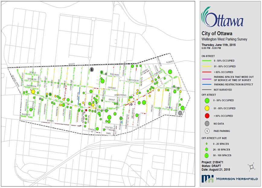
102 02
Chapter 740, Street Vending One Year Review
 STAFF REPORT ACTION REQUIRED Chapter 740, Street Vending One Year Review Date: April 7, 2015 To: From: Wards: Reference Number: Licensing and Standards Committee Executive Director, Municipal Licensing
appendix 4: Parking Management Study, Phase II
 appendix 4: Parking Management Study, Phase II A4-1 A4-2 Eastlake Parking Management Study Final Phase 2 Report Future Parking Demand & Supply January 6, 2017 Submitted by Denver Corp Center III 7900 E.
IV. ENVIRONMENTAL IMPACT ANALYSIS K.2. PARKING
 IV. ENVIRONMENTAL IMPACT ANALYSIS K.2. PARKING ENVIRONMENTAL SETTING The following analysis summarizes the findings and conclusions of the Traffic Analysis (Traffic Study), prepared by The Mobility Group,
Denver Car Share Program 2017 Program Summary
 Denver Car Share Program 2017 Program Summary Prepared for: Prepared by: Project Manager: Malinda Reese, PE Apex Design Reference No. P170271, Task Order #3 January 2018 Table of Contents 1. Introduction...
2018 Fees & Charges Parks & Recreation. Special Park Board Meeting Tuesday, November 14, 2017
 2018 Fees & Charges Parks & Recreation Special Park Board Meeting Tuesday, November 14, 2017 Presentation to the Park Board - Purpose To seek the Board s approval of the 2018 Fees and Charges as submitted
Re: 233 Armstrong Street Residential Condominium Traffic Brief
 1223 Michael Street, Suite 100, Ottawa, ON K1J 7T2 Tel: 613.738.4160 Fax: 613.739.7105 www.delcan.com August 8, 2008 TO3031TOP00 BY E-MAIL: gerry.lalonde@rogers.com Spencedale Properties 7 Cobb Court Ottawa,
Technical Memorandum
 To: Copy: From: Wally Dubyk Jennifer Murray André Sponder/Christopher Gordon, P.Eng. Re: Southminster Church 1040 Bank Street Residential Development Parking Review Technical Memorandum Date: Project:
TRANSPORTATION REVIEW
 TRANSPORTATION REVIEW - PROPOSED MIX OF LAND USES IS CONSISTENT WITH THE CITY S UNDER THE GRANVILLE BRIDGE POLICIES THAT AIM TO MEET NEIGHBOURING RESIDENTS SHOPPING NEEDS AND REDUCE RELIANCE ON AUTOMOBILE
Downtown Lee s Summit Parking Study
 Downtown Lee s Summit Parking Study As part of the Downtown Lee s Summit Master Plan, a downtown parking and traffic study was completed by TranSystems Corporation in November 2003. The parking analysis
RE: 67/71 Marquette Avenue Redevelopment Transportation Overview
 1223 Michael Street, Suite 100, Ottawa, Ontario K1J 7T2 Tel: 613.738.4160 Fax: 613.739.7105 www.delcan.com April 23, 2014 OUR REF: TO3157TOA00 BY EMAIL: mark.larose@urbanrisedevelopment.com Urban Rise
Chapter 740, Street Vending One Year Bylaw Review
 Chapter 740, Street Vending One Year Bylaw Review Licensing and Standards Committee City Hall, 2 nd Floor, Committee Room 1 Tuesday April 21, 2015 Carleton Grant, Director, Policy and Strategic Support
Draft Marrickville Car Share Policy 2014
 Draft Marrickville Car Share Policy 2014 1. Background 1.1. Marrickville Council has supported car sharing in the LGA since 2007 as part of a holistic approach to encouraging more sustainable modes of
DOWNTOWN PARKING STUDY AND STRATEGIC PLAN
 INTRODUCTION This report includes a summary of several key components of the Rapid City Downtown Parking Study and Strategic Plan, including: Current Conditions Analysis (Inventory and Occupancy and Length
Trip Generation and Parking Study New Californian Apartments, Berkeley
 Trip Generation and Parking Study New Californian Apartments, Berkeley Institute of Transportation Engineers University of California, Berkeley Student Chapter Spring 2012 Background The ITE Student Chapter
TORONTO MUNICIPAL CODE CHAPTER 903, PARKING FOR PERSONS WITH DISABILITIES. Chapter 903 PARKING FOR PERSONS WITH DISABILITIES
 903-1. General definitions. 903-2. Specific definitions 903-3. Interpretation. 903-4. Use and display of permit. Chapter 903 PARKING FOR PERSONS WITH DISABILITIES ARTICLE I On-Street and Off-Street Parking
Citizens Committee for Facilities
 Citizens Committee for Facilities AGENDA Thursday, December 11, 2014 City Council Chambers 305 3 rd Avenue East -Twin Falls, Idaho 11:30 A.M. AGENDA ITEMS Purpose By 1. Discussion and possible action on
Parks and Transportation System Development Charge Methodology
 City of Sandy Parks and Transportation System Development Charge Methodology March, 2016 Background In order to implement a City Council goal the City of Sandy engaged FCS Group in January of 2015 to update
PARKING OCCUPANCY IN WINDSOR CENTER
 PARKING OCCUPANCY IN WINDSOR CENTER TOWN OF WINDSOR, CONNECTICUT REPORT JUNE 2017 CONTENTS Background... 3 Other Relevant Data... 3 Parking Survey Design... 6 Parking Supply Inventory... 6 Parking Demand
EXECUTIVE SUMMARY. Introduction
 EXECUTIVE SUMMARY Introduction The purpose of this study is to ensure that the Village, in cooperation and coordination with the Downtown Management Corporation (DMC), is using best practices as they plan
RE: Taggart Retail Site Plan: Kanata West Proposal for Traffic Impact Study: Addendum #2
 1223 Michael Street, Suite 100, Ottawa, Ontario K1J 7T2 Tel: 613.738.4160 Fax: 613.739.7105 www.delcan.com July 9, 2014 OUR REF: TO3073TOK00 BY EMAIL: jparkes@taggart.ca/aturner@taggart.ca Taggart Commercial
CORE AREA SPECIFIC PLAN
 only four (A, B, D, and F) extend past Eighth Street to the north, and only Richards Boulevard leaves the Core Area to the south. This street pattern, compounded by the fact that Richards Boulevard is
Appendix C. Parking Strategies
 Appendix C. Parking Strategies Bremerton Parking Study Introduction & Project Scope Community concerns regarding parking impacts in Downtown Bremerton and the surrounding residential areas have existed
2.0 Development Driveways. Movin Out June 2017
 Movin Out June 2017 1.0 Introduction The proposed Movin Out development is a mixed use development in the northeast quadrant of the intersection of West Broadway and Fayette Avenue in the City of Madison.
Mercer Island Center for the Arts Parking Management Plan
 Parking Stalls Mercer Island Center for the Arts Parking Management Plan June 15, 2016 This Parking Management Plan (P) covers all tenants at the Mercer Island Center for the Arts (MICA) campus, including
Re: Addendum No. 4 Transportation Overview 146 Mountshannon Drive Ottawa, Ontario
 April 18 th, 2017 Mr. Kevin Yemm Vice President, Land Development Richraft Group of Companies 2280 St. Laurent Boulevard, Suite 201 Ottawa, Ontario (Tel: 613.739.7111 / e-mail: keviny@richcraft.com) Re:
Parking Management Strategies
 Parking Management Strategies Policy Program Potential Effectiveness (percent reduction in demand) Comments Parking Pricing Unbundling and Cash-Out Options Reduced Parking Requirements Transit/TOD Supportive
APPENDIX VMT Evaluation
 APPENDIX 2.7-2 VMT Evaluation MEMORANDUM To: From: Mr. Jonathan Frankel New Urban West, Incorporated Chris Mendiara LLG, Engineers Date: May 19, 2017 LLG Ref: 3-16-2614 Subject: Villages VMT Evaluation
TORONTO TRANSIT COMMISSION REPORT NO.
 Form Revised: February 2005 TORONTO TRANSIT COMMISSION REPORT NO. MEETING DATE: October 24, 2012 SUBJECT: DOWNTOWN RAPID TRANSIT EXPANSION STUDY (DRTES) PHASE 1 STRATEGIC PLAN ACTION ITEM RECOMMENDATIONS
Rate Review 2017 Off-Street Municipal Parking Facilities
 PA3.2 REPORT FOR ACTION Rate Review 2017 Off-Street Municipal Parking Facilities Date: August 31, 2017 To: Board of Directors, Toronto Parking Authority From: Acting President, Toronto Parking Authority
Parking Strategy Nanaimo Regional General Hospital Area Final Report
 Parking Strategy Nanaimo Regional General Hospital Area Final Report City of Nanaimo April 2018 #312-645 Fort Street, Victoria, BC V8W 1G2 T: 250.220.7060 File: 00001296.0054.01 This report is prepared
Office of Transportation Bureau of Traffic Management Downtown Parking Meter District Rate Report
 Office of Transportation Bureau of Traffic Management 1997 Downtown Parking Meter District Rate Report Introduction The City operates approximately 5,600 parking meters in the core area of downtown. 1
CITY OF VAUGHAN EXTRACT FROM COUNCIL MEETING MINUTES OF MAY 27, 2014
 Item 3, Report No. 25, of the Committee of the Whole (Working Session), which was adopted without amendment by the Council of the City of Vaughan on May 27, 2014. 3 PROPOSED RESIDENTIAL PARKING SOLUTIONS
THE CORNERSTONE APARTMENTS TRAFFIC IMPACT STUDY R&M PROJECT NO
 THE CORNERSTONE APARTMENTS SITUATED AT N/E/C OF STAUDERMAN AVENUE AND FOREST AVENUE VILLAGE OF LYNBROOK NASSAU COUNTY, NEW YORK TRAFFIC IMPACT STUDY R&M PROJECT NO. 2018-089 September 2018 50 Elm Street,
On-Street Parking Program
 On-Street Parking Program Williamsville Area - Public Information Session January 12, 2017 Project Timeline and Consultation Neighbourhood information session June 2016 Online survey August/September 2016
Vanier Parkway and Presland Road Residential Development Transportation Impact Study
 Vanier Parkway and Presland Road Residential Development Transportation Impact Study Final Report (Revised) March 2011 Submitted to: Groupe Lépine Ottawa Project No. 09-1613 Submitted by: Groupe Lépine
Trip Generation Study: Provo Assisted Living Facility Land Use Code: 254
 Trip Generation Study: Provo Assisted Living Facility Land Use Code: 254 Introduction The Brigham Young University Institute of Transportation Engineers (BYU ITE) student chapter completed a trip generation
Town of Newmarket. Parking Directions Report. Prepared for: Town of Newmarket
 Town of Newmarket Parking Directions Report Prepared for: Town of Newmarket April, 2010 TOWN OF NEWMARKET: PARKING DIRECTIONS APRIL, 2010 P:\73\28\01\Reports\APR 19 2010 - Parking Directions_ckc.doc TABLE
DIVISION 400 OFF-STREET PARKING AND LOADING
 Page 238 of 268 DIVISION 400 OFF-STREET PARKING AND LOADING INDEX Section 401 Provision of Off-Street Parking 402 Off-Street Parking for New and Existing Buildings, Structures and Uses 403 Voluntary Establishment
DEVELOPMENT PROPERTY 1627 MAXIME STREET CITY OF OTTAWA TRANSPORTATION OVERVIEW. Prepared for: Subhas Bhargava. July 9, Overview_1.
 DEVELOPMENT PROPERTY 1627 MAXIME STREET CITY OF OTTAWA TRANSPORTATION OVERVIEW Prepared for: Subhas Bhargava July 9, 2015 115-620 Overview_1.doc D. J. Halpenny & Associates Ltd. Consulting Transportation
City of Richmond. rid. Report to Committee. c::: ~ ~ :' /, ~ PWT - 21
 City of Richmond Report to Committee To: From: Re: Public Works and Transportation Committee Victor Wei, P. Eng. Director, Transportation On-Street Motorcycle and Moped Parking Date: January 26, 2016 File:
The Township Guide to Parking Restrictions
 January 2015 INTRODUCTION What are parking restrictions? They are restrictions that are established on a road which modifies what type of parking is allowed on the road. There are different types of restrictions
Downtown Parking/Wayfinding Study. Review of Recommendations to City Council: January 16, 2018
 Downtown Parking/Wayfinding Study Review of Recommendations to City Council: January 16, 2018 Tonight s Focus Objectives & Timeline Recap Study Findings Present Staff Recommendations 2018 Action items
DATE: March 21, 2017 REPORT NO. PW TYPE OF REPORT CONSENT ITEM [ ] ITEM FOR CONSIDERATION [ X ] 2.0 TOPIC
![DATE: March 21, 2017 REPORT NO. PW TYPE OF REPORT CONSENT ITEM [ ] ITEM FOR CONSIDERATION [ X ] 2.0 TOPIC](/thumbs/88/115267053.jpg "DATE: March 21, 2017 REPORT NO. PW TYPE OF REPORT CONSENT ITEM [ ] ITEM FOR CONSIDERATION [ X ] 2.0 TOPIC") PUBLIC WORKS COMMISSION PUBLIC WORKS COMMISSION DATE: March 21, 2017 REPORT NO. PW2017-022 TO: FROM: Chair and Members Committee of the Whole Operations and Administration E. (Beth) Goodger, General Manager
PUBLIC WORKS COMMISSION PUBLIC WORKS COMMISSION DATE: March 21, 2017 REPORT NO. PW2017-022 TO: FROM: Chair and Members Committee of the Whole Operations and Administration E. (Beth) Goodger, General Manager
Impact of Copenhagen s
 Impact of Copenhagen s Parking Strategy Copenhagen s parking strategy Strategy background From the 1950s, a marked increase was seen in car traffic, and streets and squares in the centre of Copenhagen
CITY OF LONDON STRATEGIC MULTI-YEAR BUDGET ADDITIONAL INVESTMENTS BUSINESS CASE # 6
 2016 2019 CITY OF LONDON STRATEGIC MULTI-YEAR BUDGET ADDITIONAL INVESTMENTS BUSINESS CASE # 6 STRATEGIC AREA OF FOCUS: SUB-PRIORITY: STRATEGY: INITIATIVE: INITIATIVE LEAD(S): BUILDING A SUSTAINABLE CITY
Newmarket GO Station Mobility Hub Study. Open House #1 MAY 18, 2017
 Newmarket GO Station Mobility Hub Study Open House #1 Naren Garg Metrolinx Advisor, RER Project Planning Amy Shepherd IBI Group Associate, Manager, Planning INTRODUCTIONS - METROLINX Metrolinx is an agency
Re: Residential Development - Ogilvie/Cummings Transportation Overview
 1223 Michael Street, Suite 100, Ottawa, ON K1J 7T2 Tel: 613.738.4160 Fax: 613.739.7105 www.delcan.com March 28, 2012 OUR REF: TO3088TOY Barry J. Hobin & Architects 63 Pamilla Street Ottawa, ON K1S 3K7
Parking Management Element
 Parking Management Element The State Transportation Planning Rule, adopted in 1991, requires that the Metropolitan Planning Organization (MPO) area implement, through its member jurisdictions, a parking
ON-STREET AND OFF-STREET PARKING SURVEY: METHODOLOGY AND RESULTS
 ON-STREET AND OFF-STREET PARKING SURVEY: METHODOLOGY AND RESULTS TOWN OF WINDSOR, CT REPORT JUNE 2016 CONTENTS Parking Survey Design... 3 Parking Supply Inventory... 3 Parking Demand Survey... 3 Surveyed
5. OPPORTUNITIES AND NEXT STEPS
 5. OPPORTUNITIES AND NEXT STEPS When the METRO Green Line LRT begins operating in mid-2014, a strong emphasis will be placed on providing frequent connecting bus service with Green Line trains. Bus hours
ACT Canada Sustainable Mobility Summit Planning Innovations in Practice Session 6B Tuesday November 23, 2010
 ACT Canada Sustainable Mobility Summit Planning Innovations in Practice Session 6B Tuesday November 23, 2010 Presentation Outline Context t of Mississauga i City Centre Implementing Paid Parking and TDM
Address Land Use Approximate GSF
 M E M O R A N D U M To: Kara Brewton, From: Nelson\Nygaard Date: March 26, 2014 Subject: Brookline Place Shared Parking Analysis- Final Memo This memorandum presents a comparative analysis of expected
Attachment D Environmental Justice and Outreach
 Attachment D Environmental Justice and Outreach ATTACHMENT D Environmental Justice and Outreach Indicate whether the project will have disproportionately high and adverse impacts on minority or low income
APPENDIX TR-1 PARKING AND QUEUING ASSESSMENT
 APPENDIX TR-1 PARKING AND QUEUING ASSESSMENT Overland Overland Traffic Consultants, Traffic Consultants, Inc. Inc. Overland Traffic Consultants 952 Manhattan Beach Boulevard, Suite #100 Manhattan Beach,
TRAFFIC DEPARTMENT 404 EAST WASHINGTON BROWNSVILLE, TEXAS City of Brownsville Speed Hump Installation Policy
 A. GENERAL Speed humps are an effective and appropriate device for safely reducing vehicle speeds on certain types of streets when installed accordance with the provisions of this policy. In order for
Zoning By-law Review of Minimum Parking Requirements Discussion Paper #2: Draft Recommendations October 2015
 Zoning By-law Review of Minimum Parking Requirements Discussion Paper #2: Draft Recommendations October 2015 Contact:Tim Moerman, Zoning, Intensification & Neighbourhoods, Planning and Growth Management
City of Meridian - Limited Parking Supply and Demand Analysis
 City of Meridian - Limited Parking Supply and Demand Analysis Prepared for: City of Meridian, Idaho Planning and Zoning 660 East Watertower, Ste. 202 Meridian, ID 83642 Prepared by: Carl Walker, Inc. 4
1 Downtown LRT Connector: Draft Concept
 Downtown LRT Connector: Draft Concept Plan November 2010 We re moving forward. Get involved. On June 21, 2010, City Council approved a street-level downtown LRT route, including a connector for the future
ARTICLE 8 OFF-STREET PARKING AND PRIVATE DRIVEWAY STANDARDS
 ARTICLE 8 OFF-STREET PARKING AND PRIVATE DRIVEWAY STANDARDS TABLE OF CONTENTS SECTION PAGE 8.1 GENERAL STANDARDS...8-2 8.2 PRIVATE DRIVEWAY PROVISIONS...8-4 8.3 OFF-STREET PARKING STANDARDS...8-5 8.4 OFF-STREET
RE: A Traffic Impact Statement for a proposed development on Quinpool Road
 James J. Copeland, P.Eng. GRIFFIN transportation group inc. 30 Bonny View Drive Fall River, NS B2T 1R2 May 31, 2018 Ellen O Hara, P.Eng. Project Engineer DesignPoint Engineering & Surveying Ltd. 200 Waterfront
WATFORD LOCAL PLAN PART 2. Review of Car Parking Policy and Standards. Evidence Base. February 2012
 WATFORD LOCAL PLAN PART 2 Review of Car Parking Policy and Standards Evidence Base February 2012 1.0 Background 1.1 The Watford District Plan 2000 contains various policies relating to the provision of
TRAVEL DEMAND FORECASTS
 Jiangxi Ji an Sustainable Urban Transport Project (RRP PRC 45022) TRAVEL DEMAND FORECASTS A. Introduction 1. The purpose of the travel demand forecasts is to assess the impact of the project components
National Household Travel Survey Add-On Use in the Des Moines, Iowa, Metropolitan Area
 National Household Travel Survey Add-On Use in the Des Moines, Iowa, Metropolitan Area Presentation to the Transportation Research Board s National Household Travel Survey Conference: Data for Understanding
Stoughton Center Parking
 Stoughton Center Parking Existing Conditions and Observations October 4, 2017 Agenda Introduction Metropolitan Area Planning Council Project Team Parking Studies Background Scope of Work Study Area Survey
On June 11, 2012, the Park Board approved the installation of three electric vehicle charging stations along Beach Avenue.
 January 8, 2017 TO: Park Board Chair and Commissioners FROM: General Manager Vancouver Board of Parks and Recreation SUBJECT: Electric Vehicle Charging Stations New Park Board Locations RECOMMENDATION
UTA Transportation Equity Study and Staff Analysis. Board Workshop January 6, 2018
 UTA Transportation Equity Study and Staff Analysis Board Workshop January 6, 2018 1 Executive Summary UTA ranks DART 6 th out of top 20 Transit Agencies in the country for ridership. UTA Study confirms
Fresno County. Sustainable Communities Strategy (SCS) Public Workshop
 Public Workshop") Fresno County Sustainable Communities Strategy (SCS) Public Workshop Project Background Senate Bill 375 Regional Transportation Plan (RTP) Greenhouse gas emission reduction through integrated transportation
Fresno County Sustainable Communities Strategy (SCS) Public Workshop Project Background Senate Bill 375 Regional Transportation Plan (RTP) Greenhouse gas emission reduction through integrated transportation
Parking and Curb Space Management Element
 Parking and Curb Space Management Element An Element of the Arlington Master Transportation Plan (MTP) Civic Federation Meeting November 10th, 2009 Background 2 MTP Goals and Policies Document adopted
Re: Amend Sections and File No ZA Marcus Lotson, Development Services Planner
 Page 1 To: From: The Planning Commission MPC Staff Date: April 5, 2016 Subject: Re: Amend Sections 8-3082 and 8-3090 Marcus Lotson, Development Services Planner Issue: Proposed amendments to the zoning
PROPOSED TRAFFIC RESOLUTION
 Reference Number: TR 50-18 Location:, Brooklyn Bus Hub - Brooklyn Proposal: Information: To provide new bus stops to create a Bus hub location on Cleveland Street, Brooklyn, as part of Wellington s new
Plattsburgh Downtown Parking Study
 Plattsburgh Downtown Parking Study Study Update October 2017 Powered by Purpose of Study Engage Community in Parking Discussion Assess Current Conditions Parking Demand Patron Service Levels Administration
Metra Milwaukee District West Line Transit-Friendly Development Plan
 Metra Milwaukee District West Line Transit-Friendly Development Plan Community Input Workshop April 6, 2011 Overview of Presentation Workshop Goals Study Context Existing Conditions Market Overview Employment
Revised Strategy for Downtown Parking
 Revised Strategy for Downtown Parking December 4, 2017 Council Workshop Presented by Jennifer McCoy, P.E., City Traffic Engineer City-Owned Parking Today 3,500 metered parking spaces Parking meters charge
Yonge-Eglinton. Mobility Hub Profile. September 19, 2012 YONGE- EGLINTON
 September 19, 2012 PEEL YORK HALTON DURHAM HAMILTON TORONTO YONGE- EGLINTON MOBILITY HUBS: places of connectivity between regional and rapid transit services, where different modes of transportation come
Construction Staging Area 4 Avenue Road
 REPORT FOR ACTION Construction Staging Area 4 Avenue Road Date: September 27, 2017 To: Toronto and East York Community Council From: Acting Director, Transportation Services, Toronto and East York District
TABLE OF CONTENTS EXECUTIVE SUMMARY...1 INTRODUCTION...3 PROJECTED FUTURE GROWTH...3 ROADWAY IMPROVEMENT PROJECTS...4 POTENTIAL FUNDING SOURCES...
 Transportation Impact Fee Study September 2014 TABLE OF CONTENTS EXECUTIVE SUMMARY...1 INTRODUCTION...3 PROJECTED FUTURE GROWTH...3 ROADWAY IMPROVEMENT PROJECTS......4 POTENTIAL FUNDING SOURCES...7 PROPOSED
TORONTO MUNICIPAL CODE CHAPTER 910, PARKING MACHINES AND METERS. Chapter 910 PARKING MACHINES AND METERS 1. ARTICLE I Parking Machines
 Chapter 910 PARKING MACHINES AND METERS 1 ARTICLE I Parking Machines 910-1. Definitions. 910-2. Payment of fee; measurement of time period. 910-3. Parking machines authorized. 910-4. Use of parking machines;
Driveway Entrance Policy for Residential Properties - District 3 - All Wards
 Driveway Entrance Policy for Residential Properties - District 3 - All Wards (City Council on August 1, 2, 3 and 4, 2000, adopted this Clause, without amendment.) The North York Community Council recommends
Public Works and Infrastructure Committee. General Manager, Transportation Services and Treasurer. P:\2015\Internal Services\rev\pw15018rev (AFS20761)
") Increases to Parking Ticket Set Fines STAFF REPORT ACTION REQUIRED Date: September 14, 2015 To: From: Wards: Reference Number: Public Works and Infrastructure Committee General Manager, Transportation
Increases to Parking Ticket Set Fines STAFF REPORT ACTION REQUIRED Date: September 14, 2015 To: From: Wards: Reference Number: Public Works and Infrastructure Committee General Manager, Transportation
TECHNICAL MEMORANDUM. Part A: Introduction
 TECHNICAL MEMORANDUM To: David J. Decker Decker Properties, Inc. 5950 Seminole Centre Ct. Suite 200 Madison, Wisconsin 53711 608-663-1218 Fax: 608-663-1226 www.klengineering.com From: Mike Scarmon, P.E.,
CITY CLERK. Warrants for All-Way Stop Sign Control and 40 km/h Maximum Speed Limits
 CITY CLERK Clause embodied in Report No. 9 of the, as adopted by the Council of the City of Toronto at its Special Meeting held on July 30, 31 and August 1, 2002. 10 Warrants for All-Way Stop Sign Control
Honorable Mayor and Members of the City Council. Parking Policies and Fee Schedule Adjustments for City-Owned Garages
 Office of the City Manager To: From: Honorable Mayor and Members of the City Council Christine Daniel, Interim City Manager Submitted by: Andrew Clough, Director, Public Works Subject: Parking Policies
D. J. Halpenny & Associates Ltd. Consulting Transportation Engineers
 D. J. Halpenny & Associates Ltd. Consulting Transportation Engineers August 24, 2015 File: 115-622 Mr. R. Baumann, President The RGB Group 277 Kirchoffer Avenue Ottawa, ON K2A 1Y1 RE: RESIDENTIAL DEVELOPMENT
CITY OF OMAHA OMAHA, NEBRASKA
 DOWNTOWN PARKING NEEDS ASSESSMENT UPDATE CITY OF OMAHA OMAHA, NEBRASKA Prepared for: City of Omaha Parking Division October 15, 2014 FINAL REPORT TABLE OF CONTENTS EXECUTIVE SUMMARY... 1 Study Purpose...
U N I V E R S I T Y O F B R I T I S H C O L U M B I A. Fall 2008 Transportation Status Report
 U N I V E R S I T Y O F B R I T I S H C O L U M B I A Fall 2008 Transportation Status Report 6 February 2009 U N I V E R S I T Y O F B R I T I S H C O L U M B I A Fall 2008 Transportation Status Report
Green Line LRT: Beltline Segment Update April 19, 2017
 Green Line LRT: Beltline Segment Update April 19, 2017 Quick Facts On April 11, 2017, City Council approved Administration s recommendation for the Green Line to be underground in the Beltline from 2 Street
Proposed Parking Strategy for Existing New Urbanism Areas. Committee of the Whole (Working Session) December 3, 2013
 December 3, 2013") Proposed Parking Strategy for Existing New Urbanism Areas Committee of the Whole (Working Session) December 3, 2013 Objective of Today s Presentation Seek Committee input prior to consultation with residents
Proposed Parking Strategy for Existing New Urbanism Areas Committee of the Whole (Working Session) December 3, 2013 Objective of Today s Presentation Seek Committee input prior to consultation with residents
Controlled Parking Zones Commentary
 Controlled Parking Zones Commentary November 2012 Residents Association Controlled Parking Zones Commentary 244884 TPN ITQ 001 C http://localhost:3579/ahjycdovl0vvtkfqau1tl0rpq1vnru5uly9ilw FjdGlvbiUzYV9hX2FmaW5kaXRlbWluZm9hY3Rpb25fYWl0ZW1fY19hMT
Public Works and Infrastructure Committee. p:/2015/clusterb/tra/northyork/pw15086
 PW9.10 STAFF REPORT ACTION REQUIRED Car-Share Parking in Permit Parking Areas Date: October 22, 2015 To: From: Wards: Reference Number: Public Works and Infrastructure Committee General Manager, Transportation
Mercer Island Town Center Parking Study Joint Commission Presentation March 16, 2016
 Mercer Island Town Center Parking Study Joint Commission Presentation March 16, 2016 Mercer Island Town Center Parking Study Study Area Town Center Bordered by Sunset Way, Island Crest Way, SE 32 nd Street,
West Broadway Transit Study. Community Advisory Committee September 17, 2015
 West Broadway Transit Study Community Advisory Committee September 17, 2015 Introductions Community Engagement Summer Outreach Fall Outreach Technical Analysis Process Update Alternatives Review Economic
Agenda Cover Memorandum
 Agenda Cover Memorandum Meeting Date: August 21, 2017 Meeting Type: COW (Committee of the Whole) City Council Budget Workshop Item Title: Final approval of an Ordinance amending various sections of Article
Trip Generation and Parking Utilization Data Collection at Mini-Mart with Gas Station
 Trip Generation and Parking Utilization Data Collection at Mini-Mart with Gas Station Final Report 2013 ITE District 6 - Data Collection Project Institute of Transportation Engineers Student Chapter at
ARTICLE 23 OFF-STREET PARKING
 ARTICLE 23 OFF-STREET PARKING ;SECTION 23-1. Residential Uses. No structure or land shall be used for any use listed in Table A of Section 8-7 under Use Items Nos. 1, 1A, 2, 3, 4, 5, 6, 7, 7A, 7B, 8, 9,
Findings from the Limassol SUMP study
 5 th European Conference on Sustainable Urban Mobility Plans 14-15 May 2018 Nicosia, Cyprus Findings from the Limassol SUMP study Apostolos Bizakis Deputy PM General Information The largest city in the
THE CORPORATION OF THE TOWNSHIP OF MIDDLESEX CENTRE BY-LAW NUMBER
 THE CORPORATION OF THE TOWNSHIP OF MIDDLESEX CENTRE BY-LAW NUMBER 2006-052 BEING A BY-LAW TO REGULATE AND CONTROL PARKING WITHIN THE TOWNSHIP OF MIDDLESEX CENTRE WHEREAS the Municipal Act authorizes local
Right-of-Way Obstruction Permit Fee Structure Minneapolis Department of Public Works May 10, 2001
 Right-of-Way Obstruction Permit Fee Structure Minneapolis Department of Public Works May 10, 2001 Revised April 5, 2005 Revised January 27, 2006 Prepared by: Steve Collin, Engineer 2.5 Revised by Douglas
Contact: Michael Parks, Manager, Traffic Engineering Services (905) Council has directed staff to report on implementing a site-specific
 Council has directed staff to report on implementing a site-specific") Flower City COMMITTEE DATE: OF COUNCIL Report Committee of Council Standing Committee of the Council of the Corporation of the City of Brampton Date: February 3, 2009 File: Subject: T00TRAF Resident Permit
Flower City COMMITTEE DATE: OF COUNCIL Report Committee of Council Standing Committee of the Council of the Corporation of the City of Brampton Date: February 3, 2009 File: Subject: T00TRAF Resident Permit
Resident Permit and Visitor Permit Guidelines
 OPERATING GUIDELINES Resident Permit and Visitor Permit Guidelines Approved by: GM, City Services May 2003 Subsequent Amendments: 9 September 2016 Associate Director (Vanessa Godden) Amended to reflect
Waco Rapid Transit Corridor (RTC) Feasibility Study
 Feasibility Study") Waco Rapid Transit Corridor (RTC) Feasibility Study Chris Evilia, Director of Waco Metropolitan Planning Organization Allen Hunter, General Manager Waco Transit System Jimi Mitchell, Project Manager AECOM
Waco Rapid Transit Corridor (RTC) Feasibility Study Chris Evilia, Director of Waco Metropolitan Planning Organization Allen Hunter, General Manager Waco Transit System Jimi Mitchell, Project Manager AECOM