Re: Boise s Annual Transportation Requests for FY Agency Reports. Attached to this report is information from each of the agencies.
|
|
|
- Alison Hancock
- 6 years ago
- Views:
Transcription

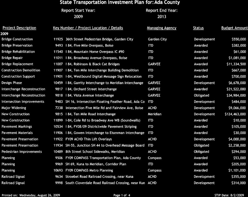
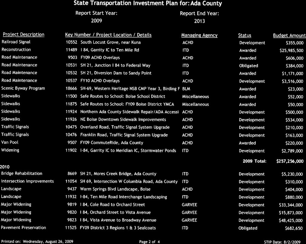
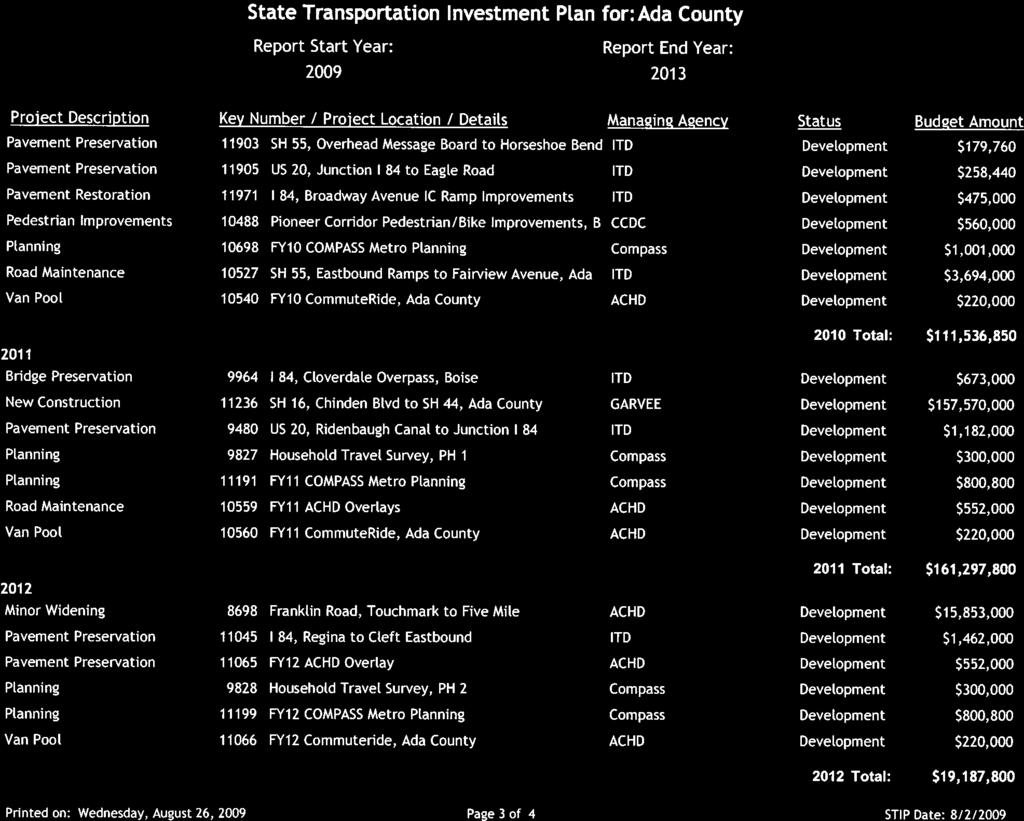
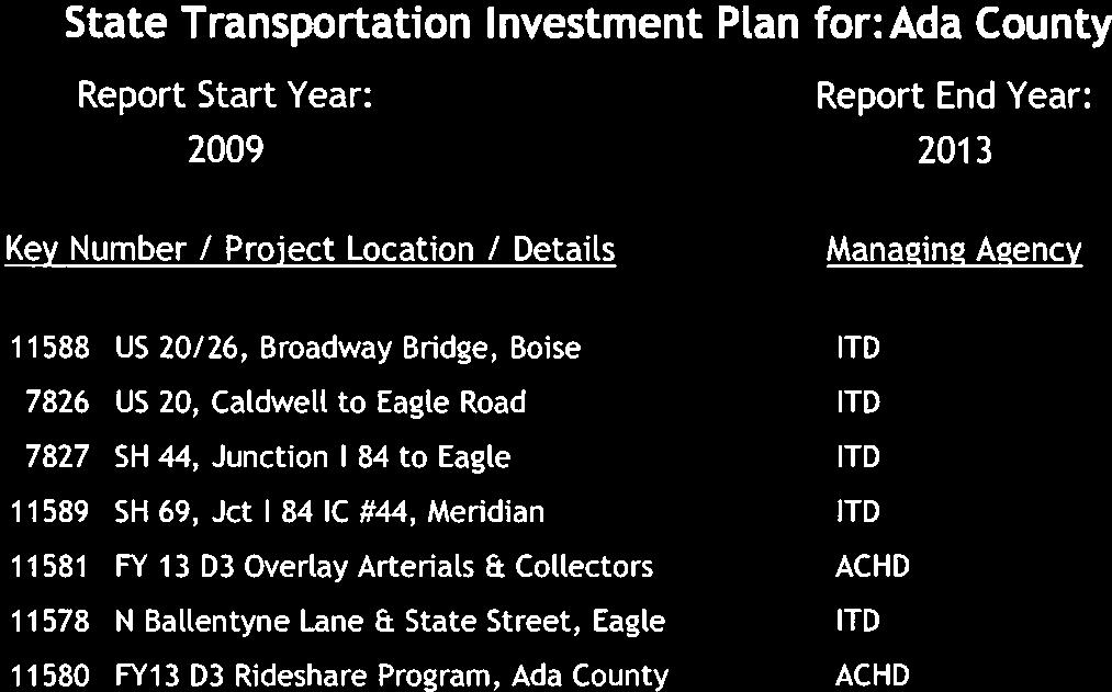
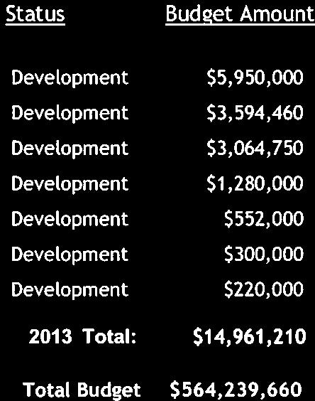
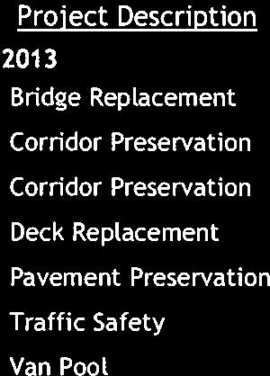
1 Date: August 24, 2009 To: From: Mayor and City Council Karen Gallagher Transportation Planner Re: Boise s Annual Transportation Requests for FY Agency Reports Requested Action: No action requested. Summary: Boise City is in the process of determining their annual transportation requests. To begin the process, we ve invited representatives from area agencies to provide a short briefing on their transportation needs and the status of planned projects in Boise. The speakers are: Toni Tisdale, Community Planning Association of Southwest Idaho (COMPASS) Phil Choate, Idaho Transportation Department (ITD) Mark Carnopis, Valley Regional Transit (VRT) Sabrina Anderson, Ada County Highway District (ACHD) Sarah Stobaugh, Boise School District Attached to this report is information from each of the agencies. Next Steps: At the Council s meeting on September 15, 2009, staff will present a draft list of transportation projects/studies for review. The public is invited to comment on the draft list at this meeting. Based on the direction received from the Mayor and Council, staff will finalize the City s requests for action by the Mayor and Council on September 22, The deadline for submitting requests is October 1, Attachments: COMPASS: Overview and Changes to the Transportation Improvement Program ITD: List of Current Projects in Ada County VRT: TIP Project List Summary ACHD: Current (FY ) Prioritization List of: - Roadways - Rebuild-intersections - New intersections - Community programs Boise School District: Overview of the School District s Prioritization Process and Submitted Requests for FY
2 CITY OF BOISE SEPTEMBER 1, 2009 Toni Tisdale, Principal Planner - Transportation COMPASS , ext 228
3 What is a TIP? Transportation Improvement Program Five-year budget document for federal-funded projects updated annually First 2-3 years are most critical. Required by the U.S. Department of Transportation in order to obtain federal funds. Includes all federally funded projects. Includes all regionally significant projects in non-attainment / maintenance areas (Ada County). Combined TIP for Northern Ada County, the Nampa Urbanized Area, and other Canyon County projects.

4 TIP Document
5 TIP - Requirements Must be consistent with the regional long-range transportation plan (Communities in Motion). Must be financially constrained. Must involve the public. Must meet air quality requirements in non-attainment and maintenance areas (Ada County) a process called conformity finding.
6 TIP Project Prioritization There is not enough federal aid to fund all transportation needs. COMPASS staff is currently developing a new process to prioritize projects for federal funding. The draft concept and outline is expected to be approved by September 2009 in order to use the new process in the FY TIP Update. New projects will follow the new criteria. The prioritization criteria will be tweaked as the system is tested. The criteria is tied very closely with the goals of Communities in Motion, which is currently going through a limited update, for approval in August 2010.
7 DRAFT Prioritization Process If yes, Go The new process will likely contain a Go/No Go criteria with elements such as these: 1. Does project follow the COMPASS Complete Streets Policy? 2. Is project on a priority corridor in the Long-Range Transportation Plan? If no, No Go 3. Is project consistent with the Community Choices land use scenario? 4. Has the sponsor committed available local match through a formal agency action, such as a Resolution? 5. Does the sponsor have the ability to provide ongoing operating/maintenance funds? Progress to more specific criteria
8 TIP Tracking & Monitoring Federal funds are limited. It is imperative to obligate federal funds early in the fiscal year. Federal funds not obligated by early summer are subject to a funding sweep. Funds are removed from delayed projects and moved to projects that are ready for obligation. COMPASS has an increasing role in tracking and monitoring federal funds. Project tracking helps insure that federal funds are obligated as quickly as possible. Project monitoring provides assistance to COMPASS members in the progress of projects.


9 Timeline for TIP Process *ACHD requires city/county endorsement of priorities by October 1.

10 TIP on the Website


11

12
13


14
 Project description: This project involves the design and construction of a building on a halfblock parcel of land in Downtown Boise bordered by Idaho, 11th and")
15 Downtown Boise Multimodal Center ADA Bus Stop Improvements Short-Range TIP Project Summaries Cost: $11.5 million (includes 20% local match) Project description: This project involves the design and construction of a building on a halfblock parcel of land in Downtown Boise bordered by Idaho, 11th and Bannock Streets. This facility would include bus bays, and may include parking spaces, bicycle parking, a transit/visitor information center, public restrooms and street-orientated retail opportunities. Status/Timeline: The Federal Transit Administration recently issued a FONSI (Finding Of No Significant Impact) following a review of the environmental assessment report. Negotiations are currently under way for land acquisition. Once completed, the focus will turn to design and construction. Construction is expected to begin in Cost: $3.5 million ($3 million in stimulus funds, $500,000 in other federal and local funds) Project description: This project involves improving accessibility to bus stops for people with disabilities (curb cuts, sidewalks, concrete pads, etc.). There are 865 bus stops in the ValleyRide system (101 of which are in Canyon County). A consulting firm is currently reviewing its recommendations and VRT staff recommendations towards a goal of developing a final priority list. Status/Timeline: An RFP is expected to be issued in late September. Work is expected to begin this fall and take about one year to complete. Vehicle Replacement Cost: $4.75 million (no local match required) Project description: This project involves purchasing new buses or paratransit vans to replace leased buses or buses that are past their useful lives. Buses purchased for the Boise system will operate on compressed natural gas (CNG). Status/Timeline: Developing specs for buses. An effort is being made to piggyback on an existing bus order from another system in order to expedite manufacture and delivery of buses. Technology Improvements Cost: $205,000 (no local match required) Project description: This project involved the development of an interactive Web map and trip planner for the ValleyRide website. Status/Timeline: Development of this program has been ongoing (with assistance from the Idaho Transportation Department and is expected to be in operation sometime this fall. Route Restructuring and Service Improvements VRT planning staff are currently working on changes to eight Boise city routes. These changes would include route modifications and additional service. Other changes being proposed are adding one morning and one evening run to the Route 40 Nampa/Meridian Express, and modifying the section of Route 42 Nampa/Meridian Express that passes through Meridian. VRT also is seeking federal funding to implement a commuter route on Ustick Road.
16 Comments and Recommendations Total Points (Total Technical Pts + Total Programming Pts) Total Programming Development Acquisition Logical Sequencing Scheduled in Previous FYWP (Construction Year) Agency Support Leveraging non-achd Funds Funds Expended Total Technical Project Cost/Lane/Mile Current PCI Freeway Diversion Route System Improvement Points Street Classification Accident Rate/MVMT Effective Additional Capacity Estimated Project Cost Proposed Number of Lanes Current Number of Lanes Functional Street Classification GIS No FYWP Construction Year Project Overall Rank* Roadway Project Prioritization: Five Year Work Program Draft Technical Criteria Programming Criteria 1 Franklin Rd, Touchmark Rd / Five Mile Rd (Phase I) 2010 RD282 PA 2 5 $6,472, PA Eagle Rd, Victory Rd / Ridenbaugh Canal 2011 RD PA 2 5 $4,210, PA Meridian Rd and Main Street (Ph 1 of Split Corridor), I-84 to Frankli 2010 RD PA 7 6 $4,983, PA Five Mile Rd, Franklin Rd / Fairview Ave 2013 F038 MA 2 5 $7,758, MA Three Cities River Crossing UF C PA 0 5 $105,153, PA Deer Flat Rd, SH-69 / Ten Mile Rd 2010 RD125 MA 2 3 $1,822, MA Ustick Rd, Locust Grove Rd / Leslie Way UF RD PA 2 5 $3,445, PA Meridian Rd and Main Street (Ph 2 of Split Corridor), Franklin Rd to 2013 RD MA 5 8 $12,608, MA th Street Extension, Fairview Ave / State St 2014 RD MA 0 5 $8,880, MA Ustick Rd, Meridian Rd / Locust Grove Rd UF RD PA 2 5 $5,138, PA Fairview Ave, Cloverdale Rd / Five Mile Rd UF RC0127 PA 5 7 $6,350, PA Fairview Ave, Locust Grove Rd / SH 55 (Eagle Rd) UF RC0133 PA 5 7 $6,260, PA Fairview Ave, SH 55 (Eagle Rd) / Cloverdale Rd UF RC0130 PA 5 7 $6,230, PA Cloverdale Rd, 1000' north of Fairview Ave / Ustick Rd PD RC0087 MA 2 5 $5,550, MA Fairview Ave, Meridian Rd / Locust Grove Rd UF RC0135 PA 5 7 $6,840, PA State St, Pierce Park Lane / Collister Dr UF RD PA 5 7 $9,435, PA State St, Collister / 36th St UF RD PA 5 7 $8,110, PA Franklin Rd, Ten Mile Rd / Linder Rd 2012 RC0165 PA 2 5 $6,471, PA State St, Glenwood St/ Pierce Park Lane UF RD PA 5 7 $8,675, PA State St, 36th St / 27th St UF RD PA 5 7 $8,570, PA Cloverdale Rd, Franklin Rd / 1000' south of Fairview Ave PD RD MA 2 5 $6,859, MA Ten Mile Rd, Cherry Lane / Ustick Rd 2014 RD188 MA 2 5 $7,290, MA Ustick Rd, Duane Dr / Cloverdale Rd UF RD MA 2 5 $4,517, MA Fairview Ave, Maple Grove Rd / Cole Rd UF RD PA 5 7 $6,500, PA Linder Rd, Franklin Rd / Ustick Rd UF RD077 MA 2 5 $10,200, MA Project delayed at request of Meridian. 25 Ten Mile Rd, Franklin Rd / Cherry Lane 2010 RD309 MA 2 5 $10,775, MA Fairview Ave, Five Mile Rd / Maple Grove Rd UF RC0131 PA 5 7 $7,188, PA Adams / 37th St / Clay St 2014 RD UC 2 3 $908, UC Ustick Rd, Cloverdale Rd / Five Mile Rd PD RD220 MA 2 5 $9,031, MA McMillan Rd, Locust Grove Rd / SH 55 (Eagle Rd) UF RC0240 MA 2 5 $4,300, MA Five Mile Rd, Fairview Ave / Ustick Rd UF RD195a MA 2 5 $8,443, MA Franklin Rd, Black Cat Rd / Ten Mile Rd UF RC0152 PA 2 5 $7,620, PA Hill Rd Extension, State Hwy 55 / State Street 2012 RD308 C 0 3 $8,305, C Cloverdale Rd, Ustick Rd / McMillan Rd UF RC0092 MA 3 5 $4,580, MA Cole Rd, I-84 / Franklin Rd FTR RD PA 3 5 PA 35 Cole Rd / Glenwood St Extension FTR RD279 PA 0 3 PA Other Bench/Valley projects to be completed first. 37 Orchard St, Gowen Road / I-84 On-Ramp FTR RD PA 3 5 PA th Street, Hill Rd / Cartwright Rd UF RD307 MA 0 3 $12,180, MA Ten Mile Rd, Victory Rd / Overland Rd UF RC0299 PA 2 5 $6,578, PA Cloverdale Rd, McMillan Rd / Chinden Blvd (US 20/26) UF RD MA 2 5 $6,335, MA Linder Rd, Overland Rd / Franklin Rd FTR RC0207 MA 0 5 MA Project on hold for ITD GARVEE projects on I Franklin Rd, McDermott Rd / Black Cat Rd FTR RC0161 PA 2 5 PA 43 36th St, Chinden Blvd / Clay St RD UC 2 3 $795,000 0 UC Ustick Rd, Linder / Ten Mile FTR RD PA 2 5 PA 43 Victory, Five Mile / Maple Grove FTR RD MA 3 5 MA 46 Lake Hazel, Cloverdale / Five Mile FTR RD PA 2 5 PA 46 Eagle Rd, Amity / Victory FTR RD PA 2 5 PA 8/19/2009 Page 1 of 2
17 Comments and Recommendations Total Points (Total Technical Pts + Total Programming Pts) Total Programming Development Acquisition Logical Sequencing Scheduled in Previous FYWP (Construction Year) Agency Support Leveraging non-achd Funds Funds Expended Total Technical Project Cost/Lane/Mile Current PCI Freeway Diversion Route System Improvement Points Street Classification Accident Rate/MVMT Effective Additional Capacity Estimated Project Cost Proposed Number of Lanes Current Number of Lanes Functional Street Classification GIS No FYWP Construction Year Project Overall Rank* Technical Criteria Programming Criteria 46 Ustick Rd, Linder Rd / Meridian Rd FTR RD PA 2 5 PA 49 Lake Hazel, Five Mile / Maple Grove FTR RD PA 2 5 PA 49 Cole Rd, Lake Hazel Rd / Desert Ave FTR RD MA 2 5 MA 49 36th Street Extension, Cartwright / Bogus Basin Rd FTR RD MA 0 2 MA 52 Maple Grove Rd, Amity Rd / Victory Rd FTR RD MA 2 5 MA 52 Cloverdale Rd, Victory Rd / Overland Rd FTR RD MA 2 5 MA 52 Linder Rd, Ustick Rd / McMillan FTR RD MA 2 5 MA 52 Cole Rd, Desert Ave / Victory Rd FTR RD MA 2 5 MA 56 Victory, Cloverdale / Five Mile FTR RD MA 2 5 MA 56 Victory, Maple Grove / Cole FTR RD MA 4 5 MA Overland Rd, Vista Ave / Federal Way FTR RD169 MA 2 3 MA Linder Rd, McMillan / Chinden (US 20/26) FTR RD MA 2 5 MA 60 Cloverdale Rd, Overland Rd / Franklin Rd RD MA 3 5 MA Not possible until Overpass is Widened. 61 Meridian Rd, Cherry Lane / Ustick FTR RD MA 2 5 MA 61 Maple Grove Rd, Lake Hazel Rd / Amity Rd FTR RD MA 2 5 MA 61 Ten Mile Rd, Overland Rd / Franklin Rd UF RC0297 PA 2 5 PA Likely constructed with interchange by ITD. 61 Cloverdale Rd, Amity Rd / Victory Rd FTR RD MA 2 5 MA 61 Ten Mile Rd, Ustick Rd / McMillan FTR RD MA 2 5 MA 61 Cloverdale Rd, Lake Hazel Rd / Amity Rd FTR RD MA 2 5 MA 61 Maple Grove Rd, Victory Rd / Overland Rd FTR RD MA 3 5 MA 61 Maple Grove Rd, Fairview Ave / Ustick Rd FTR RD196a MA 2 5 MA 69 Franklin Rd, Touchmark Rd / Five Mile Rd (Phase II) 2011 RD PA 2 5 $4,154, PA Ten Mile Rd, McMillan / Chinden (US 20/26) FTR RD MA 2 5 MA 69 Lake Hazel, Maple Grove / Cole FTR RD PA 2 5 PA 69 Meridian Rd, Ustick Rd / McMillan FTR RD MA 2 3 MA 73 Linder Rd, Chinden Blvd (US 20/26) / SH 44 (State St) FTR RD MA 2 5 MA Locust Grove Rd, Victory / Overland FTR RD MA 2 5 MA Locust Grove Rd, Ustick Rd / McMillan FTR RD MA 2 3 MA Locust Grove Rd, McMillan / SH 20 / 26 (Chinden) FTR RD MA 2 3 MA 77 Cloverdale Rd, Columbia Rd / Lake Hazel Rd FTR RD MA 2 5 MA 78 Meridian Rd, McMillan / Chinden (US 20/26) FTR RD MA 2 3 MA 79 Pine, Meridian / Locust Grove RD MA 2 3 MA Widen from 2 lanes to 3 lanes with Ped/Bike facilities 80 Avalon, E Orchard / Swan Falls Rd FTR RD MA 2 3 MA 80 Pine Ave W/ Executive Drive, Parkdale / Cloverdale Road FTR RD MA 2 5 MA 82 Overland Rd Ten Mile Rd / Linder Rd 2011 DC /19/2009 Page 2 of 2
18 Comments Total Programming Leverage Development Acquisition Support Funding Technical Freeway Cost Range Peak Hour Volume Peak Hour Ratio Improvement to System Change VC Safety Estimated Project Cost GIS No FYWP Construction Year Project Overall Rank* Intersection Rebuild Projects - Prioritization: Five Year Work Program DRAFT Technical Criteria Programming Criteria Eagle Rd and Fairview Ave IN240 $13,600, CIP - Urban Interchange Maple Grove Rd and Franklin Rd 2013 IN $1,313, ITD STIP FY2006. CIP - Widen North Leg to 5 Lanes and Modify Signal Emerald St and Five Mile IN ITD STIP for FY2008. Included in Five Mile, Franklin/Fairview Project (CIP Roadway Project) Cloverdale Rd and Franklin IN Included in Franklin, Cloverdale/Five Mile (CIP Roadway Project) Franklin & Five Mile IN $2,500, State St and Collister Dr UF IN $1,677, CIP - Widen North Approach to 3 Lanes Fairview Ave and Cole Rd UF IN099 $9,527, CIP - Reconstruction and Widening of Intersection. Project has been delayed due to R/W Costs Overland Rd and Vista FTR IN $500, CIP - Widen East Approach to 5 Lanes Maple Grove Rd and Overland FTR IN $500, Include with Maple Grove, Victory to Overland (CIP Roadway Project) Fairview Ave and Five Mile Rd 2010 IN $2,692, ITD STIP FY2008. Included in Five Mile, Franklin/Fairview Project (CIP Roadway Project) State St and Glenwood UF IN $7,776, Five Mile Rd and Overland FTR IN $1,000, Included with Five Mile, Overland/Franklin (CIP Roadway Project) Latah and Overland FTR IN $250, Widen Overland to 5 Lane Cross Section at Intersection Avenue D / E; Main St / 04th Street; Bridge Ave (Kuna) 2014 IN050 $2,734, CIP - Modification Chinden Blvd (US 20/26) and Veterans Memorial Parkway FTR IN $1,359, CIP - Widen North Leg to 7 Lanes and Modify Signal Cole Rd and Franklin Rd FTR IN $3,260, CIP - Widen North Approach to 7 Lanes and All Other Approaches to 6 Lanes Franklin Rd and Roosevelt St and Rose Hill FTR IN $1,200, CIP - Widen Approach Legs Eagle Rd (SH55) and McMillan FTR IN $5,110, FY ITD Rebuild of Intersection as part of the Eagle Road Study State St and Veterans Memorial Parkway FTR IN $500, CIP - Widen West Approach Along VMP to 7 Lanes Cole Rd and Victory FTR IN $500, CIP - Widen Approach Legs to 5 Lanes Cloverdale Rd and Ustick Rd PD IN $5,805, Included with Cloverdale, Fairview/Ustick (CIP Roadway Project) Federal Way and Gowen (Hwy 21) FTR IN $2,000, CIP - Improve to 7-lane Section Both Roadways Avenue B and Broadway and Idaho and Main and Warm Spri FTR IN $2,000, CIP - Improve to 7-lane Section Both Roadways Franklin & Linder FTR IN $3,836, Five Mile Rd and Victory FTR IN $3,777, CIP - Widen Approach Legs on East and South to 5 Lanes 36th Street and Hill Rd and Catalpa Dr UF IN239b $2,542, CIP - Delay Requested by Boise City and Neighborhood Ustick Rd and Locust Grove Rd PD IN $2,676, Glenwood and Mountainview Dr / Goddard FTR IN $1,375, CIP - Widen West to 4 Lanes and North to 6 Lanes Linder and Main St FTR IN $1,000, West Avalon St and Shortline and Bridge FTR IN $1,000, Beacon and Broadway (US 20/26) FTR IN $2,000, CIP - Improve to 7-lane Section Both Roadways Maple Grove Rd and Victory FTR IN $4,933, CIP - Widen Approach Legs to 5 Lanes 8/19/2009 Page 1 of 1
19 Comments Total Points Programming Points Leverage Development Acquisition Support Funding Technical Points Freeway Diversion Cost Adverse Spacing Suburban Adverse Spacing Downtown ADT Improvement Pedestrian Accident Minor Warrrant Major Warrant Lead Agency Project Total GIS No FYWP Construction Year Project Overall Rank* New Intersection Signal Project Prioritization Five Year Work Program DRAFT Technical Criteria Programming Criteria MEETS WARRANTS 1 Ustick Rd and Linder Rd IN $4,824,000 ACHD Included in Linder, Franklin/Ustick. 2 Maple Grove Rd and Hackamore Dr 2011 IN132 $1,568,000 ACHD Adjacent to Overpass at I-84. Fill or wall Required. 3 SH 69 (Meridian Rd) and Columbia Rd IN $853,000 ITD Rural Signal Study. 4 SH 44 / State St / Ballantyne Ln Realignment 2012 IN $3,435,000 ITD Part of Intersection Realignment Project. 4 Pine Ave and Linder Rd 2012 IN270 $4,735,000 ACHD Adjacent to Meridian high School. 6 SH 55 and Hill Rd 2012 IN $175,000 ITD McMillan Rd and Locust Grove Rd 2011 IN $4,470,000 ACHD North Meridian Plan. 7 Black Cat Rd and Cherry Lane UF IN $3,855,382 ACHD Rural Signal Study. 9 Lake Hazel Rd and SH69 (Meridian Road) FTR IN $3,037,000 ITD Rural Signal Study. 10 Farman St and Gowen Rd and Pleasant Valley Rd UF IN $1,505,000 ACHD Assumed Pleasant Valley Realigned with Farman. Discuss wi 11 Ustick Rd and Ten Mile Rd 2014 IN $0 ACHD Included in Ten Mile, Cherry/Ustick. 12 Federal Way and Victory Rd UF IN $304,000 ACHD Potential Future Signal Location. 12 Amity Rd and Eagle Rd UF IN $1,085,000 ACHD A New Middle & Elementary School will be build on the Northw 12 SH 16 and Beacon Light Rd FTR IN $487,000 ITD Public Request for Signal. ITD has safety projects scheduled. 12 Star Rd and Ustick Rd UF IN $1,350,000 ACHD CIP. 16 Chinden Blvd (US 20/26) and Ten Mile FTR IN $5,098,010 ITD North Meridian Plan. 17 Allumbaugh St and Fairview FTR IN $1,000,000 ACHD Very Close to Fairview/Liberty Signal. 18 Eagle Rd and Plaza FTR IN $0 ACHD Eagle City Request for Traffic Signal. 19 Ten Mile Rd and Amity Rd 2014 IN $1,484,000 ACHD Rural Signal Study. Potential Round-a-bout location. 20 Black Cat Rd and McMillan FTR IN $1,800,000 ACHD North Meridian Plan. 21 Eagle Rd (SH55) and River Valley Street FTR IN $600,000 ITD Added due to inclusion in the Eagle Road Corridor Improveme DOES NOT MEET WARRANTS 1 Deer Flat Rd and Ten Mile FTR IN $1,500,000 ACHD Potential need due to new Kuna High School. 2 Franklin Rd and Liberty St UF IN $2,245,000 ACHD CIP. 2 Edgewood and Floating Feather FTR IN $200,000 ACHD Included in Floating Feather, Edgewood/Eagle. 4 Linder Rd and Porter FTR IN $500,000 ACHD This is for information purposes only. Do not Prioritze. 5 Star Rd and McMillan Rd FTR IN $1,350,000 ACHD CIP. Traffic made some improvements that should reduce acc 6 Black Cat Rd and Franklin Rd PD IN $0 ACHD Rural Signal Study. Recommend interim left turn improvment 7 Deer Flat Rd and Linder FTR IN $500,000 ACHD Potential need due to new Kuna High School. 7 Irving St and Maple Grove FTR IN $85,000 ACHD The project, Maple Grove, Franklin/Fairview includes only the 9 Boise Ave and Linden IN $0 ACHD Public Request for Signal. 9 Deer Flat Rd and Kay Street IN $500,000 ACHD This is for information purposes only. Do not prioritize. 11 Ustick Rd and Black Cat Rd FTR IN $985,000 ACHD North Meridian Plan. 12 Overland Rd and Ten Mile Rd 2011 IN $5,447,817 ACHD Rural Signal Study. 12 Ten Mile Rd and Columbia FTR IN $1,000,000 ACHD Hill Rd and Plaza Dr and State St 2013 IN $359,000 ACHD Hill Road Extension to State Street at Plaza. 15 Amity Rd and Holcomb Rd - Traffic Signal FTR IN166 $200,000 ACHD New Signal & Left Turn Lane on Amity. Crossing for Holcomb 15 Ten Mile Rd and Victory Rd PD IN $1,800,000 ACHD Rural Signal Study. 17 Maple Grove Rd and Desert Ave UF IN $1,348,000 ACHD Locust Grove Rd and Victory Rd UF IN $1,500,000 ACHD Bergeson and Law FTR IN $500,000 ACHD Public Request for Signal. 17 Boise Ave and Linder FTR IN $500,000 ACHD Kuna City Location. 21 Ten Mile Rd and McMillan Rd UF IN $5,108,000 ACHD North Meridian Plan. 21 Hill Rd and Pierce Park FTR IN $1,275,000 ACHD CIP. 8/19/2009 Page 1 of 2
20 Comments Total Points Programming Points Leverage Development Acquisition Support Funding Technical Points Freeway Diversion Cost Adverse Spacing Suburban Adverse Spacing Downtown ADT Improvement Pedestrian Accident Minor Warrrant Major Warrant Lead Agency Project Total GIS No FYWP Construction Year Project Overall Rank* Technical Criteria Programming Criteria 21 Orchard St and Targee FTR IN $224,000 ACHD Cloverdale Rd and Edna FTR IN $1,500,000 ACHD Public Request for Signal. 21 Hubbard Rd and SH69 (Meridian Road) FTR IN $2,661,000 ITD Rural Signal Study. 21 McMillan Rd and Shamrock FTR IN $1,000,000 ACHD Requires right of way purchase for left turn lane on McMillan. 27 SH 21 and Warm Springs FTR IN $443,000 ITD CIP. 27 Boise Ave and Division IN $92,000 ACHD CIP. 27 Cotterell and Overland FTR IN $250,000 ACHD Land Developer Request for Consideration. 27 Eckert Rd and Warm Springs FTR IN $250,000 ACHD Developer Deposit. (North end of Future Traffic Signal). 27 Ustick Rd and Wildwood FTR IN $500,000 ACHD Citizen request. He believes a signal will reduce traffic on Wil 32 Ustick Rd and McDermott FTR IN $1,350,000 ACHD North Meridian Plan 32 SH 55 and Beacon Light FTR IN $2,622,752 ITD Hill Rd and Seamans Gulch FTR IN $300,000 ACHD CIP. 32 Saturn Way and Victory FTR IN $250,000 ACHD Public Request for Signal. 32 Hill Rd and Horseshoe Bend Rd UF IN276 $1,701,000 ACHD Boise Ave and Eckert and Healey FTR IN $500,000 ACHD Public Agency Request for signal. Left turn lanes on Healey w 37 Edna St and Maple Grove FTR IN $1,250,000 ACHD Public Request for Signal. 39 Boise Ave and Law Ave FTR IN164 $250,000 ACHD Currently AWSC at this location. 39 Amity Rd and Maple Grove Rd IN $1,745,000 ACHD Collister Dr and Hill FTR IN $1,000,000 ACHD Public Agency Request for Signal. 39 Federal Way and Targee FTR In $250,000 ACHD Post Office Request for Signal. 43 SH 44 (State St) and Bogart Lane UF IN023a $745,000 ITD Meridian Rd (SH69) and Calderwood FTR IN $250,000 ITD Public Request for Signal. 43 Federal Way and Malad FTR IN $250,000 ACHD Potential future Signal Location. 46 Highland and ParkCenter FTR IN $1,000,000 ACHD Developer will need to realign intersection and close tyrell for 47 Chinden Blvd (US 20/26) and Blackcat FTR IN $1,500,000 ITD North Meridian Plan. 47 Corporate and Meridian FTR IN $400,000 ACHD Timing and need dictated by Corporate Extension to west of M 47 Council Springs and Mill Station and Warm Sprin FTR IN $1,000,000 ACHD CIP. 47 Eagle Rd (SH55) and Wainwright FTR IN $250,000 ITD Developer Driven. 51 Chinden Blvd (US 20/26) and McDermott FTR IN $1,500,000 ITD North Meridian Plan. 51 Main (E 1st) and Watertower FTR IN $250,000 ACHD ACHD Proposed Signal. 53 Chinden Blvd (US 20/26) and Coffey FTR IN $250,000 ITD Too Close to Chinden/Glenwood Major Intersection. 8/19/2009 Page 2 of 2
21 PLANNING DATA PROJECT ACHD PRIORITY RANK Origin CITY LIMITS CITY REQUEST NUMBER SCHOOL DISTRICT SD REQUEST NUMBER Bike Master Plan Route # Community Programs of Boise, Bown/Holcomb App B Boise PBL 2 Boise, Capital/Joyce 28 PBTP B Boise PBL 3 Boise, Holcomb/Eckert App B Boise PBL 4 Boise Ave Curb Ramps App B Boise PBL 5 Cherry, Owyhee/Vista 53 BSD B Boise 6 N 6 Cole, W Rim Acres/Victory 79 BSD AC Boise 14 PBL 7 Deer Flat, Linder / Church Property 43 PBTP K Kuna PSR 8 East 2 1/2 St, Carlton/Fairview 24 CR M 4 Meridian N 9 Fairview, Kimball/Maple Grove 35 Maint B Boise PBL 10 Floating Feather, Park/Ballantyne 71 CR E 1 Meridian PBL 11 Gekeler, Linden/Carter App B Boise PBL 12 Hill, SH 55 / Horshoe Bend 110 CR E 3 Boise PBL 13 Kent, Chinden / Adams 116 PBTP G Boise 14 Linder, Claire/Five Mile Creek 4 MSD M 1 Meridian 1 PBL 15 Madison Ave, 27th/125' E App B Boise N 16 Main Street south of SH CR S 3 Meridian N 17 Overland, Vista / Federal Way 65 PBTP B Boise PBL 18 Pine, Meridian/Nola 28 PBTP M Meridian PBL 19 River St, Americana/Interfaith Sanctuary 42 PBTP B Boise N 20 State Street, 2nd / Academy 12 CR E 2 Meridian PSR 21 Ustick, Nieman/Linder 62 CR/MSD M 3 Meridian 6 PBL 22 West 3rd St, Center St/Star Rd 89 CR S 4 Meridian PSR Key Project Origin Codes Pedestian Bicycle Transition Plan Application City Request Boise School District Request Meridian School District Request PBTP App CR BSD MSD Bike Master Plan Route Codes
22 Existing Proposed None Planned Bike Lane Signed Route E P N BL SR A short term improvement according to the Bike Master Scoping Alternates 1 Coffey, Chinden / Penny Lane 120 PBTP G PSR 2 Irving, Kimball/Mitchell 65 Maint B Boise 17 PSR 3 Kootenai, Roosevelt/Vista 17 PBTP B Boise 5 EBL 4 Mitchell, Victory/Amity 65 BSD AC Boise 9 N 5 Mountain View, Cole/Ustick 53 App B Boise ESR 6 Pennsylvania, Boise/ParkCenter 85 BSD B Boise 16 EBL Roadway Projects 1 Amity, Federal Way / Surprise Way NA B PBL 2 Ten Mile, Victory/Old Overland NA M PBL 3 Ustick, Locust Grove / Leslie Way 6 M PBL 4 ustick, Meridian/Locust Grove 9 M PBL Intersection Projects 1 Ustick and Locust Grove 27 M 2 Ten Mile and Victory 12 AC 3 Black Cat and Franklin NA AC 4 Ustick and Meridian NA M
23 NOTES SENA approved for a Boise Reinvest Grant for this project ($15K) SENA approved for a Boise Reinvest Grant for this project ($18K), high priority in the PBTP SENA approved for a Boise Reinvest Grant for this project ($69K) Repare or replace curb ramps identified in the application, identify any other pedestrian facilities repairs required within the project limits Finish sidewalk connection on both sides of Cherry Ln Sidewalk on both sides of Cole Pedestrian facilities on the south side of the road; Evaluate ped crossing at SE property line of Reed Elementary to NE property line of LDS church. Provide a connection to Cole Valley School. Side of the road is TBD. Originally a project requested of Maintenance Department; Sidewalks on S side #1 request by Eagle, would essentially fill in gaps between existing detatched sidewalks; Bike lane picks up at Moon Valley SENA approved for a Boise Reinvest Grant for this project ($22K) Improvements could possibly be made concurrently with the Hill Road Extension Pedestrian facilities on at least one side of the roadway Filling in a gap on E side of Linder will make one continuous connection to Sawtooth Middle, city recommends pathway on E side of the ditch. Include Tim Curns of Meridian Public Works on the scoping team Curb, Gutter, Sidewalk on S side of road to match extisting; may also evaluate N side, as it appears that sidewalk can be placed within ACHD ROW and will make the N section continuous May require implementation in phases. Very long segment. Project recommended by the ACHD Traffic Department; filling in gaps in existing sidewalk Provide a safe pedestrian and bicycle facility. Is a gap in the bike network; cost estimate may exist from previous ad hoc scoping efforts Small sidewalk segment on N side of River. Provides a connection for homeless walking to Interfaith Sanctuary Detatched sidewalk Filling is gaps in the sidewalk system would make a continuous connection; crosswalk at Ten Mile; possible temporary solution prior to Ten Mile and Ustick intersection project Talk with City of Star for better project description.
24 Plan Pedestrian facilities on at least one side of the roadway; bikeway signage Finish sidewalk connections Likely too costly for full treatment Sidewalk on Mitchell from Victory and the pathway connection to Amity Elementary Have had several requests from the neighborhood and Commissioners; evaluate a phased approach; Include neighborhood in discussions; neighborhood requests at least the south side be completed Sidewalk on south side Widen to 3 lanes with bike lanes in either direction and a signal at Holcomb Not yet prioritized, was added because of demand increase after the TMI opening; could potentially be included with the Ten Mile and Victory int if funding available Widen roadway from 2 to 5 lanes Widen roadway from 2 to 5 lanes Modify signal and reconstruct/widen approaches Consider for roundabout, per TL High accident location. Consider for rounabout w/slight realingment south, per TL Project split out from the Ustick, Meridian/Locust Grove project
25 Independent School District of Boise City #1 Boundaries, Transportation, and Traffic Safety 8169 W Victory Rd - Boise, ID (208) Fax (208) Date: August 3, 2009 To: From: Subject: Dr. Pete Bailey Sarah Stobaugh Approval of Prioritization List to Ada County Highway District As part of our on-going collaboration with ACHD to improve walking and biking routes to school, attached is our annual prioritized list of pedestrian safety projects for consideration in ACHD s prioritization process. The prioritized school district projects will be given additional weight in ACHD s prioritization process. ACHD requires that our District s prioritized list be endorsed by the Boise School District Board of Trustees through a formal resolution or approval. The process to establish Boise Schools prioritized list of projects is to review the projects that were already on ACHD s list of community projects, add requests submitted by schools participating in the Safe Routes to School program, and finally add other projects that would help to eliminate safety busing. The prioritization process considered and gave points based on the following factors: 1. Is the project less than 1.5 miles from a school? 2. Is the school participating in the Safe Routes to School Program? 3. Will the project help to eliminate busing? 4. How many bus routes could be eliminated? 5. How many students are affected? 6. What is the age/grade level of the affected students? 7. How complex is the project how feasible to be completed? The entire list of seventy-three (73) projects and scoring for all projects was reviewed and approved by the Safe Routes to School Leadership Committee on Thursday, July 23, Based on the scores from our prioritization process, attached is a list of the twenty-three (23) highest scoring projects that would help pedestrian safety for the students of the Boise School District. Also included again this year is a Feasibility List of potential pedestrian pathway connections for ACHD s future consideration. 1
26 ACHD Staff has specifically requested that we retain all projects in our prioritization process until they have been completed. I am happy to report that many of the projects listed as our top priorities are in the process of being evaluated and/or scheduled for construction. Those projects include: Pedestrian Crossing light on Maple Grove at Irving Sidewalks on Cassia Street between Curtis Rd and Orchard St Sidewalks on Curtis Rd between Overland and Franklin Sidewalks on Five Mile between Victory Rd & Amity Rd Sidewalks on Amity Rd between Five Mile and Carie Way Sidewalks on Roosevelt St between Cassia St & Rose Hill St Sidewalks on Bloom Street between State St & Collister Rd Sidewalks on Sunset Ave between 38 th St & 32nd St Sidewalks on Collister Dr between State St & Hill Rd Sidewalks on State St between Collister Dr & Veterans Memorial Parkway Sidewalks on Catalpa Dr between Collister Dr & 36 th St Sidewalks on Kootenai St between Roosevelt St & Vista Ave I am requesting a formal resolution from the Board approving the attached prioritization list to be forward to ACHD for inclusion in their prioritization process. 2
27 2009 PRIORITIZED LIST OF PEDESTRIAN PROJECTS BOISE SCHOOL DISTRICT Priority #1 BSD Project # BSDHor09-1 Pedestrian crossing light at Maple Grove & Irving # Elementary students # Jr High students - 0 # Sr High students - 0 A pedestrian crossing to cross Maple Grove Road at Irving Street. This project in tandem with Project # BSDHor09-2, completion of sidewalks along Fairview Avenue from Milwaukee to Maple Grove, would allow 188 students attending Horizon Elementary safe pedestrian access to school and would eliminate three bus routes. The Boise School District would provide two adult crossing guards to assist students crossing Maple Grove. The Boise School District is willing to pay the cost of the crossing light, estimated to be $80,000 - $100,000. Priority #2 ACHD Project Cassia St, Curtis Rd / Orchard St # Elementary students - 67 # Jr High students - 0 # Sr High students Sidewalks on both sides of Cassia St. This project would improve pedestrian safety for high school students walking to Borah High. This project in tandem with ACHD s project to add sidewalks on Curtis Rd between Franklin Rd and Overland Rd would also allow the school district to discontinue safety busing for students living on the east side of Curtis Rd attending Grace Jordan Elementary. The District would like ACHD to consider as part of this project a pedestrian crossing light across Curtis Rd somewhere near Edson St. Priority #3 BSD Project # BSDHigh09-7 Highlands Elementary Attendance Area # Elementary students # Jr High students - 0 # Sr High students - 0 Crosswalks, ped ramps, and improved signage along designated walking routes to school throughout the Highlands attendance area. Priority #4 ACHD Project Curtis Rd, Overland / Franklin # Elementary students # Jr High students - 0 # Sr High students - 0 Sidewalks on both sides of Curtis Rd. This would allow more direct access for students living on the west side of Curtis Rd walking to Grace Jordan Elementary. This project in tandem with ACHD s project to add sidewalks on Cassia St between Orchard St & Curtis Rd would also allow the school district to discontinue safety busing for students living on the east side of Curtis Rd attending Grace Jordan Elementary. The District would like ACHD to consider as part of this project a pedestrian crossing light across Curtis Rd somewhere near Edson St. Priority #5 BSD Project # BSDHor09-2 Fairview Ave, Milwaukee / Maple Grove # Elementary students - 79 # Jr High students - 12 # Sr High students - 0 Complete missing sidewalk sections along Fairview Avenue between Milwaukee & Maple Grove. This project in tandem with Project # BSDHor09-1, a pedestrian crossing signal at Maple Grove & Irving, would allow 79 students living at Fairview Crossing Apartments attending Horizon Elementary safe pedestrian access to school and would help to eliminate three bus routes. The Boise School District would provide two adult crossing guards to assist students crossing Maple Grove at Irving St. This project would also improve pedestrian access for Jr. High students walking to/from Fairmont Jr. High. Priority #6 ACHD Project Five Mile Rd, Victory Rd / Amity Rd # Elementary students # Jr High students - 0 # Sr High students - 0 Sidewalks on both sides of Five Mile Rd between Victory Rd and Amity Rd. This project in tandem with ACHD s project to add sidewalks on Amity Road between Five Mile and Carie Way has the potential to enable the school district to eliminate safety busing for students living west of Five Mile Rd and also for those living on the east side of Five Mile Rd between Seneca Dr and Amity Rd if additional improvements are part of the project. A pedestrian crossing light somewhere near Reutzel Dr, as well as either a pathway connection to S Varian Ave / W Sandy River Dr via Leland Way OR sidewalks along the north side of Amity Rd between Five Mile Rd and Amity Elementary would be necessary before safety busing could be eliminated. 3
28 Priority #7 ACHD Project Amity Rd, Five Mile / Carie Way # Elementary students - 95 # Jr High students - 0 # Sr High students - 0 Sidewalks on the North side of Amity Road between Five Mile and Carie Way. This project in tandem with ACHD s project to add sidewalks on both sides of Five Mile between Victory Road and Amity Road has the potential to enable the school district to eliminate safety busing for students living west of Five Mile Rd and also for those living on the east side of Five Mile Rd between Seneca Dr and Amity Rd if additional improvements are part of the project. We ask that a pedestrian crossing light somewhere near Reutzel Dr be included as part of this project. Priority #8 ACHD Project Roosevelt St, Cassia St / Franklin Rd (Rose Hill) # Elementary students - 67 # Jr High students - 28 # Sr High students - 6 Sidewalks preferably on both sides of Roosevelt Street, but at least on the west side, from Cassia Street to Franklin Rd (Rose Hill). This project has the potential to enable the school district to eliminate safety busing for Jefferson Elementary students living West of Roosevelt St. It will also improve safety for Jr. High students walking to/from South Jr. High and a few High School students walking to/from Borah High. Priority #9 ACHD Project Irving St, Kimball St / Mitchell St # Elementary students # Jr High students - 0 # Sr High students - 0 Finish sidewalk connections on Irving St between Kimball St and Mitchell St. This would improve pedestrian safety for students walking to/from Horizon Elementary School. Priority #10 ACHD Project Cherry Ln, Owyhee St / Vista Ave # Elementary students - 96 # Jr High students - 52 # Sr High students - 0 Finish sidewalk connection on both sides of Cherry Ln between Owyhee St and Vista Ave. This would improve pedestrian safety for students walking to/from South Jr. High and also to/from Whitney Elementary and Owyhee Elementary. Priority #11 BSD Project # SH08-1 Duncan Ln - 2 locations # Elementary students - 51 # Jr High students - 0 # Sr High students - 0 Curb ramps and crosswalks across Duncan Ln near Ben St & Dempsey St. This project would allow the school district to discontinue safety busing for 51 elementary students walking to/from Shadow Hills Elementary School. Priority #12 BSD Project # Mon09-1 Roosevelt St, Overland Rd / Cassia St # Elementary students - 46 # Jr High students - 27 # Sr High students - 5 Sidewalks preferably on both sides of Roosevelt Street, but at least on the west side, between Overland Road and Cassia Street. This project along with sidewalk improvements along Clark St, Kootenai St, and Cassia St, has the potential to enable the school district to eliminate safety busing for Monroe Elementary students living west of Roosevelt St. It will also improve safety for Jr. High students walking to/from South Jr. High and a few High School students walking to/from Borah High. Priority #13 BSD Project # WP09-1 Pedestrian Crossing Light, Boise Utter St # Elementary students - 28 # Jr High students - 0 # Sr High students - 20 Pedestrian Crossing Signal on Boise Avenue at the end of the pathway near Utter St. This project in tandem with ACHD s project to add sidewalks on Pennsylvania St between Boise Ave & Parkcenter Blvd has the potential to enable the school district to eliminate safety busing for White Pine Elementary students living north of Boise Ave. It will also improve safety for Timberline High School students. The District would furnish an adult crossing guard to assist elementary students to cross Boise Ave. 4
29 Priority #14 ACHD Project Bloom St, State St / Collister Dr # Elementary students - 40 # Jr High students - 12 # Sr High students - 0 Sidewalks on both sides of Bloom St between State St and Collister Dr. This project in tandem with ACHD s project to add sidewalks on Collister Dr between State St and Hill Rd would allow the district to eliminate safety busing for students attending Cynthia Mann Elementary. Priority #15 ACHD Project Sunset Ave, 38 th St / 32 nd St # Elementary students # Jr High students - 5 # Sr High students - 0 Sidewalks on Sunset Ave between 38 th St & 32 nd St. This project would improve the safety of elementary students walking to/from Taft Elementary and also Jr. high students walking to/from Hillside Jr. High. Priority #16 ACHD Project Collister Dr, State St / Hill Rd # Elementary students - 50 # Jr High students - 29 # Sr High students - 0 Sidewalks along both sides of Collister Dr between State St and Hill Rd. Collister Dr is the dividing line between two elementary attendance areas. Students living on the west side of Collister Dr attend Cynthia Mann Elementary. Those living on the east side of Collister Dr attend Collister Elementary. This project would make safer access for students to walk to/from either elementary school, as well as students walking to/from Hillside Jr. High. This project in tandem with ACHD project to add sidewalks on Bloom St between State St and Collister Dr would allow the school district to discontinue safety busing for Cynthia Mann Elementary students living on Bloom St west of Collister Dr. Priority #17 ACHD Project Randolph Dr, Aurora Dr / Cameron St # Elementary students - 82 # Jr High students - 12 # Sr High students Redesign the intersection of Aurora/Randolph/Cameron St to allow safer pedestrian walkway for elementary students living north of the rim walking to Grace Jordan Elementary and also for high school students living south of the rim walking to Borah High. We request that the project also include pedestrian improvements along Cameron St from Randolph Dr to Fairfield Ave. This project would not only enhance safety for students, but would improve neighborhood access to Borah Park and pool, as well as the new Boise Parks & Recreation Community Center located at Grace Jordan Elementary. Priority #18 ACHD Project State St, Collister Dr / Veterans Memorial Parkway # Elementary students 80* # Jr High students - 10 # Sr High students - 0 Sidewalks along both sides of State St between Collister Dr and Veterans Memorial Parkway. *Although there are 80 elementary students living in neighborhoods on the south side of State St attending Taft Elementary, it is unlikely that the district would eliminate safety busing for these students even if sidewalks were installed on State St. The intersection of State St / Veterans Memorial Parkway / 36 th St is too large an intersection to expect elementary students to cross at that location. However the district would potentially consider eliminating safety busing for Hillside Jr High students living in neighborhoods on the south side of State St if they had sidewalks to get safely to a pedestrian crossing light. Priority #19 ACHD Project Pennsylvania St, Boise Ave / Parkcenter Blvd # Elementary students - 16 # Jr High students - 0 # Sr High students - 11 Finish sidewalk connection on the south side of Pennsylvania St between Parkcenter Blvd and Boise Ave. This project, along with a pedestrian crossing light across Boise Ave somewhere near the pedestrian pathway terminating near Boise Ave & Utter St would allow the district to eliminate safety busing for students attending White Pine Elementary. Priority #20 ACHD Project Catalpa Dr, Collister Dr / 36 th St # Elementary students - 87 # Jr High students - 81 # Sr High students - 0 5
Date: July 5, Mayor and City Council Karen Gallagher Transportation Planner Re: Capital Improvement Plan Update 2007 Draft for Adoption by ACHD
 Date: July 5, 2006 To: From: Mayor and City Council Karen Gallagher Transportation Planner Re: Capital Improvement Plan Update 2007 Draft for Adoption by ACHD Background: Every three years, ACHD updates
**AGENDA** Open Discussion/Announcements/Introductions. III. Consent Agenda 9:40 *A. Approve the March 18, 2014 Meeting Minutes pages 2-3
 Interagency Consultation Committee April 15, 2014 9:30 a.m. 10:30 a.m. Community Planning Association 700 N. East 2nd Street, 2nd Floor Large Conference Room, Meridian NOTICE: This packet contains only
INTEGRATED ADA COUNTY HIGHWAY DISTRICT
 2019 2023 INTEGRATED Five-Year Work Plan ADA COUNTY HIGHWAY DISTRICT 2019 2023 INTEGR!TED FIVE-YE!R WORK PL!N FISCAL YEA R 201 9 2023 ADOPT ED SEP TEMBER 26, 201 8 T A B L E O F C O N T E N T S Project
Executive Summary. Treasure Valley High Capacity Transit Study Priority Corridor Phase 1 Alternatives Analysis October 13, 2009.
 Treasure Valley High Capacity Transit Study Priority Corridor Phase 1 Alternatives Analysis October 13, 2009 Background As the Treasure Valley continues to grow, high-quality transportation connections
Public Information Packet FY Fargo-Moorhead Metropolitan Transportation Improvement Program (TIP)
") Public Information Packet FY - Fargo-Moorhead Metropolitan Transportation Improvement Program (TIP) Comment Form Annual Element TIP Projects - TIP Projects Year - Metropolitan Transportation Improvement
Public Information Packet FY - Fargo-Moorhead Metropolitan Transportation Improvement Program (TIP) Comment Form Annual Element TIP Projects - TIP Projects Year - Metropolitan Transportation Improvement
Transportation Improvement Program (TIP) Candidate Project List for Public Review
 Candidate Project List for Public Review") 2011-2014 Transportation Improvement Program (TIP) Candidate List for Public Review Table 1 Annual Listing Of Federal Aid Obligation For Federal Fiscal Year 2010 North Dakota s Number Transit 410083 Transit
2011-2014 Transportation Improvement Program (TIP) Candidate List for Public Review Table 1 Annual Listing Of Federal Aid Obligation For Federal Fiscal Year 2010 North Dakota s Number Transit 410083 Transit
Rocky Mount. Transportation Plan. Transportation Planning Division. Virginia Department of Transportation
 2020 Transportation Plan Developed by the Transportation Planning Division of the Virginia Department of Transportation in cooperation with the U.S. Department of Transportation, Federal Highway Administration
SOUTHERN GATEWAY. Transportation and Trinity River Project Committee 11 May 2015
 SOUTHERN GATEWAY Transportation and Trinity River Project Committee 11 May 2015 Southern Gateway Project History Began in 2001 as a Major Investment Study [ MIS ], Schematic, and Environmental Assessment
2016 PSRC REGIONAL & KING COUNTYWIDE EASTSIDE FUNDING AWARDS. Eastside Transportation Partnership September 9, 2016
 2016 PSRC REGIONAL & KING COUNTYWIDE EASTSIDE FUNDING AWARDS Eastside Transportation Partnership September 9, 2016 1 2 PSRC 2016 Project Selection Process 2018-2020 Estimated FHWA Funds Available: (Summary)
MOTION NO. M Preferred Alternative for the Puyallup Station Access Improvement Project
 MOTION NO. M2014 64 Preferred Alternative for the Puyallup Station Access Improvement Project MEETING: DATE: TYPE OF ACTION: STAFF CONTACT: Capital Committee Board PROPOSED ACTION 8/14/14 8/28/14 Recommendation
Transportation. Background. Transportation Planning Goals. Level of Service Analysis 5-1
 Transportation portion of the city s stormwater utility, and state road and fuel taxes. Background The transportation needs of the City of Lacey and its planning areas are met by a growing multimodal network
The range of alternatives has been reviewed with the RTAC Subgroup and the preliminary analysis is proceeding on the following HCT alternatives:
 Attachment 2 Boise Treasure Valley Phase 1 Alternatives Analysis August 14, 2009 Introduction The Treasure Valley High Capacity Transit Priority Corridor Phase 1 Alternatives Analysis is being prepared
Brigham City 1200 West Box Elder Creek Bridge - Widening Project Type Reconstruction
 Brigham City 1200 West Box Elder Creek Bridge - Widening Project Type Reconstruction 550 North to 650 North $ 1,750,000 $ 1,582,113 To widen an existing bridge on 1200 West over Box Elder Creek that will
Waco Rapid Transit Corridor (RTC) Feasibility Study
 Feasibility Study") Waco Rapid Transit Corridor (RTC) Feasibility Study Chris Evilia, Director of Waco Metropolitan Planning Organization Allen Hunter, General Manager Waco Transit System Jimi Mitchell, Project Manager AECOM
Waco Rapid Transit Corridor (RTC) Feasibility Study Chris Evilia, Director of Waco Metropolitan Planning Organization Allen Hunter, General Manager Waco Transit System Jimi Mitchell, Project Manager AECOM
ANDERSON PROPERTY SITE ANALYSIS
 ANDERSON PROPERTY SITE ANALYSIS Introduction The Montgomery County Department of Transportation (MCDOT) initiated a feasibility study in the fall of 2012 to evaluate the need for transit service expansion
Agenda. Utility Undergrounding Strategies & Laguna Canyon Road Master Plan
 Utility Undergrounding Strategies & Laguna Canyon Road Master Plan January 17, 2017 City Council Meeting 2 Agenda Progress since March 2016 Status of undergrounding and road widening between El Toro Rd.
The Eastern Connector Study November, 2007 planning for the future
 The Eastern Connector Study November, 2007 planning for the future In late 2006, Albemarle County and the City of Charlottesville jointly initiated the Eastern Connector Corridor Study. The Project Team
I-820 (East) Project Description. Fort Worth District. Reconstruct Southern I-820/SH 121 Interchange
 Project Description. Fort Worth District. Reconstruct Southern I-820/SH 121 Interchange") I-820 (East) Project Description Fort Worth District Reconstruct Southern I-820/SH 121 Interchange I-820 from approximately 2,000 feet north of Pipeline Road/Glenview Drive to approximately 3,200 feet
I-820 (East) Project Description Fort Worth District Reconstruct Southern I-820/SH 121 Interchange I-820 from approximately 2,000 feet north of Pipeline Road/Glenview Drive to approximately 3,200 feet
FREQUENTLY ASKED QUESTIONS
 THE PROJECT Last updated on 9/8/16 FREQUENTLY ASKED QUESTIONS What s happening on Highway 169? The Minnesota Department of Transportation (MnDOT) is planning to rebuild and repair the infrastructure on
CAPITAL FUND 9510 STREET & SIDEWALK IMPROVEMENTS FIVE-YEAR CAPITAL IMPROVEMENT PROGRAM FISCAL YEARS
 9510 STREET & SIDEWALK IMPROVEMENTS FIVE-YEAR CAPITAL IMPROVEMENT PROGRAM FISCAL YEARS 2019-2023 9510 STREET & SIDEWALK IMPROVEMENTS - 01 STREET AND SIDEWALK MAINTENANCE PROGRAM $1,250,000 $0 $1,250,000
Public Information Workshop
 Public Information Workshop Charlotte County-Punta Gorda MPO - Meeting Rooms A and B March 29, 2018 Welcome to the Public Information Workshop for Harborview Road Project Development and Environment (PD&E)
STH 60 Northern Reliever Route Feasibility Study Report
 #233087 v3 STH 60 Northern Reliever Route Feasibility Study Report Washington County Public Works Committee Meeting September 28, 2016 1 STH 60 Northern Reliever Route Feasibility Study Hartford Area Development
Committee Report. Transportation Committee. Business Item No
 Committee Report Business Item No. 2015-280 Transportation Committee For the Metropolitan Council meeting of December 9, 2015 Subject: METRO Blue Line Extension (Bottineau Light Rail Transit) Revised Scope
Unified Corridor Investment Study DRAFT Step 2 Scenario Analysis Report
 Unified Corridor Investment Study DRAFT Step 2 Scenario Analysis Report REVISIONS 1. Table 39: New Public Investments for Operation and Maintenance Costs 2. Appendix A-10: Passenger Rail Service - Operations
IMPROVEMENT CONCEPTS
 IMPROVEMENT CONCEPTS for the South Novato Transit Hub Study Prepared by: January 11, 2010 DKS Associates With Wilbur Smith Associates IMPROVEMENT CONCEPTS Chapter 1: Introduction 1. INTRODUCTION The strategic
Exhibit A Sound Transit Board Resolution R Selecting the bicycle, pedestrian, and parking access improvements to be built for the Puyallup
 Exhibit A Sound Transit Board Resolution R2016-07 Selecting the bicycle, pedestrian, and parking access improvements to be built for the Puyallup Access Improvement Project. RESOLUTION NO. R2016-07 Selecting
Metro Transit Update. Christina Morrison, Senior Planner Metro Transit BRT/Small Starts Project Office. John Dillery, Senior Transit Planner
 Metro Transit Update Christina Morrison, Senior Planner Metro Transit BRT/Small Starts Project Office John Dillery, Senior Transit Planner Metro Transit Service Development May 16, 2013 1 Transit Planning
Draft Results and Open House
 Waco Rapid Transit Corridor (RTC) Feasibility Study Draft Results and Open House Chris Evilia, Director of Waco Metropolitan Planning Organization Allen Hunter, General Manager Waco Transit System Jimi
FREQUENTLY ASKED QUESTIONS
 THE PROJECT Last updated on 2/19/16 FREQUENTLY ASKED QUESTIONS What s happening on Highway 169? The Minnesota Department of Transportation (MnDOT) is planning to rebuild and repair the infrastructure on
Federal Way Link Extension
 Federal Way Link Extension Draft EIS Summary Route & station alternatives and impacts Link Light Rail System Map Lynnwood Mountlake Terrace Lynnwood Link Extension Shoreline 14th Northgate 40 Northgate
2030 Multimodal Transportation Study
 2030 Multimodal Transportation Study City of Jacksonville Planning and Development Department Prepared by Ghyabi & Associates April 29,2010 Introduction Presentation Components 1. Study Basis 2. Study
Letter EL652 City of Mercer Island. Page 1. No comments n/a
 Letter EL652 City of Mercer Island Page 1 No comments n/a Page 2 Response to comment EL652 1 Section 4.5.3 of the Final EIS presents the range of potential impacts of the project. This project also lists
Point A Point B Point C Point D. Fulton County Board of Commissioners and Mayors Meeting December 14, 2017
 Fulton County Board of Commissioners and Mayors Meeting December 14, 2017 Master Plan Overview Phase 1 Community Vision and Existing Transit Conditions Phase 2 Scenario Development Phase 3 Transit Master
Major Widening/New Roadway
 Revised Evaluation s Major Widening/New Roadway This page provides a summary of any revisions made to the draft scores presented at the October th Attributable Funds Committee meeting. The information
CITY OF PORT TOWNSEND, WASHINGTON CAPITAL IMPROVEMENT PLAN
 Page 1 of 3 CITY OF PORT TOWNSEND, WASHINGTON CAPITAL IMPROVEMENT PLAN The six-year Capital Improvement Plan (CIP) includes capital projects for 2017 2022. This plan includes capital projects that add
Table of Contents INTRODUCTION... 3 PROJECT STUDY AREA Figure 1 Vicinity Map Study Area... 4 EXISTING CONDITIONS... 5 TRAFFIC OPERATIONS...
 Crosshaven Drive Corridor Study City of Vestavia Hills, Alabama Table of Contents INTRODUCTION... 3 PROJECT STUDY AREA... 3 Figure 1 Vicinity Map Study Area... 4 EXISTING CONDITIONS... 5 TRAFFIC OPERATIONS...
US 81 Bypass of Chickasha Environmental Assessment Public Meeting
 US 81 Bypass of Chickasha Environmental Assessment Public Meeting March 14, 2013 Introductions ODOT FHWA SAIC Meeting Purpose Present need for bypass Provide responses to 10/04/11 public meeting comments
Revised Evaluation Scores. System Preservation
 Revised Evaluation s System Preservation This page provides a summary of any revisions made to the draft scores presented at the October th Attributable Funds mmittee meeting. The information below highlights
Develop ground transportation improvements to make the Airport a multi-modal regional
 Project Overview TRANSPORTATION IMPROVEMENTS WHAT ARE THE PROJECT GOALS? Transportation transportation hub. Develop ground transportation improvements to make the Airport a multi-modal regional Land Use
Dixie Transportation Planning Office
 A project must be given a yes rating on items 1 & 2 in order to be prioritized. Sponsor: St. George City Project: Pioneer Parkway Type: Road Widening and Reconstruction Rev. 9/17/2010 Dixie Transportation
CEDAR AVENUE TRANSITWAY Implementation Plan Update
 CEDAR AVENUE TRANSITWAY Implementation Plan Update EECUTIVE SUMMARY DECEMBER 2015 Executive Summary In 2013, the Twin Cities metropolitan area s first bus rapid transit (BRT) line, the METRO Red Line,
Highway 18 BNSF Railroad Overpass Feasibility Study Craighead County. Executive Summary
 Highway 18 BNSF Railroad Overpass Feasibility Study Craighead County Executive Summary October 2014 Highway 18 BNSF Railroad Overpass Feasibility Study Craighead County Executive Summary October 2014 Prepared
FasTracks News. RTD s Eagle P3 Transit Project Nears Halfway Mark to Opening Day EP3 will add three commuter rail lines to metro area in 2016
 July 29, 2013 Welcome to Inside RTD FasTracks a monthly e- update to keep you informed about the progress of the Regional Transportation District's FasTracks program. FasTracks News RTD s Eagle P3 Transit
The Jack A. Markell Trail Delaware s Bicycle Highway New England Bike- Walk Summit
 The Jack A. Markell Trail Delaware s Bicycle Highway 2018 New England Bike- Walk Summit The Jack A. Markell Trail Sometimes a very difficult project, including significant investment and perseverance,
5. OPPORTUNITIES AND NEXT STEPS
 5. OPPORTUNITIES AND NEXT STEPS When the METRO Green Line LRT begins operating in mid-2014, a strong emphasis will be placed on providing frequent connecting bus service with Green Line trains. Bus hours
TransNet Dollars Keep San Diego Moving
 TransNet Dollars Keep San Diego Moving In 1987, San Diego region voters approved the TransNet program a half-cent sales tax to fund a variety of important transportation projects throughout the region.
Reston Transportation Strategy July 9, 2018
 Reston Transportation Strategy July 9, 2018 Background: On February 11, 2014, the Board of Supervisors adopted the Reston Phase I Comprehensive Plan Amendment for the core areas of Reston between Sunset
CITY OF TORRANCE PUBLIC WORKS DEPARTMENT ENGINEERING DIVISION INFRASTRUCTURE UPDATE
 CITY OF TORRANCE PUBLIC WORKS DEPARTMENT ENGINEERING DIVISION INFRASTRUCTURE UPDATE TUESDAY, DECEMBER 5, 2017 1 DISCUSSION TOPICS Update of Infrastructure Action Plan (IAP) o Sidewalk and Roadway projects
Public Works. Capital Projects FY
 Public Works Capital Projects FY 2015-17 Projects Completed FY 2014 All Done Projects! Residential and Collector Street Paving Lower Westside Arterial Street Rehab: Front, River St South, Soquel Hwy 1
Tulsa Transportation Management Area. Urbanized Area Surface Transportation Program
 Tulsa Transportation Management Area Urbanized Area Surface Transportation Program FFY 2022 Application Information Sponsor Location Description STP Request Other Funds Broken Arrow Elm Place: Kenosha
BROWARD BOULEVARD CORRIDOR TRANSIT STUDY
 BROWARD BOULEVARD CORRIDOR TRANSIT STUDY FM # 42802411201 EXECUTIVE SUMMARY July 2012 GOBROWARD Broward Boulevard Corridor Transit Study FM # 42802411201 Executive Summary Prepared For: Ms. Khalilah Ffrench,
Improving Accessibility of Regional Bus Stops and Pathways
 Customer Service and Operations Committee Board Information Item III-A March 13, 2014 Improving Accessibility of Regional Bus Stops and Pathways Page 3 of 17 Washington Metropolitan Area Transit Authority
ACTION TRANSMITTAL No
 Transportation Advisory Board of the Metropolitan Council of the Twin Cities DATE: January 4, 2016 TO: ACTION TRANSMITTAL No. 2016-19 TAC Funding and Programming Committee PREPARED BY: Joe Barbeau, Senior
Basic Project Information
 FY 2015-16 PROJECT DESCRIPTION FORM (7B) Submitting Agency: Fairfax County Basic Project Information Project Title: South Van Dorn Street and Franconia Road Interchange 7B Project Type (check one): Roadway
Railyard Alternatives & I-280 Boulevard Feasibility Study 1 RAILYARD ALTERNATIVES & I-280 BOULEVARD (RAB) FEASIBILITY STUDY
 FEASIBILITY STUDY") Railyard Alternatives & I-280 Boulevard Feasibility Study 1 RAILYARD ALTERNATIVES & I-280 BOULEVARD (RAB) FEASIBILITY STUDY RAB Citizen Working Group Meeting, August 1 st 2016 CITIZEN WORKING GROUP (CWG)
Railyard Alternatives & I-280 Boulevard Feasibility Study 1 RAILYARD ALTERNATIVES & I-280 BOULEVARD (RAB) FEASIBILITY STUDY RAB Citizen Working Group Meeting, August 1 st 2016 CITIZEN WORKING GROUP (CWG)
RTID Travel Demand Modeling: Assumptions and Method of Analysis
 RTID Travel Demand Modeling: Assumptions and Method of Analysis Overall Model and Scenario Assumptions The Puget Sound Regional Council s (PSRC) regional travel demand model was used to forecast travel
6/6/2018. June 7, Item #1 CITIZENS PARTICIPATION
 June 7, 2018 Item #1 CITIZENS PARTICIPATION 1 Item #2 APPROVAL OF MINUTES Item #3 TRAC GOALS, FRAMEWORK & AGENDA REVIEW 2 COMMITTEE GOALS Learn about Southern Nevada s mobility challenges, new developments
DRAFT. Enrollment Projections Report. February 12, 2016
 February 12, 2016 3325 Hilliard Rome Road Hilliard, Ohio 43026 P: 614.798.8828 f: 614.798.8839 www.dejongrichter.com Table of Contents Acknowledgements... 2 Executive Summary... 3 Enrollment Projection
Clearlake Road (State Road 501) Project Development & Environment (PD&E) Study
 Project Development & Environment (PD&E) Study") Clearlake Road (State Road 501) Project Development & Environment (PD&E) Study FROM MICHIGAN AVENUE TO INDUSTRY ROAD BREVARD COUNTY, FLORIDA Financial Project ID No: 433605-1-22-01 Federal Aid Project
Clearlake Road (State Road 501) Project Development & Environment (PD&E) Study FROM MICHIGAN AVENUE TO INDUSTRY ROAD BREVARD COUNTY, FLORIDA Financial Project ID No: 433605-1-22-01 Federal Aid Project
Chapter 7: Travel Demand Analysis. Chapter 8. Plan Scenarios. LaSalle Community Center. Image Credit: Town of LaSalle
 Chapter 7: Travel Demand Analysis Chapter 8 Plan Scenarios LaSalle Community Center. Image Credit: Town of LaSalle 164 Chapter 8: Plan Scenarios Moving Ahead for Progress in the 21 st Century Act (MAP
Challenges in a Post-Katrina Environment East-West Corridor Project Overview February, 2007
 EAST-WEST CORRIDOR Challenges in a Post-Katrina Environment East-West Corridor Project Overview February, 2007 Presentation Agenda Project Overview / Purpose and Need Highway Component Transit Component
AGENDA INTERCITY TRANSIT AUTHORITY WORK SESSION January 20, :30 P.M. 1) APPROVAL OF AGENDA 1 min.
 APPROVAL OF AGENDA 1 min.") AGENDA INTERCITY TRANSIT AUTHORITY WORK SESSION January 20, 2016 5:30 P.M. CALL TO ORDER 1) APPROVAL OF AGENDA 1 min. 2) INTRODUCTIONS 5 min. A. Welcome City of Yelm Councilmember Molly Carmody B. Welcome
AGENDA INTERCITY TRANSIT AUTHORITY WORK SESSION January 20, 2016 5:30 P.M. CALL TO ORDER 1) APPROVAL OF AGENDA 1 min. 2) INTRODUCTIONS 5 min. A. Welcome City of Yelm Councilmember Molly Carmody B. Welcome
SH 249 IN GRIMES COUNTY. Open House April 3, 2014
 SH 249 IN GRIMES COUNTY Open House April 3, 2014 Meeting Agenda Purpose of Meeting Today: Review the purpose and need for the SH 249 Grimes County project Review the proposed project and alternatives Discuss
Citizens Committee for Facilities
 Citizens Committee for Facilities AGENDA Thursday, December 11, 2014 City Council Chambers 305 3 rd Avenue East -Twin Falls, Idaho 11:30 A.M. AGENDA ITEMS Purpose By 1. Discussion and possible action on
Green Line LRT: Beltline Recommendation Frequently Asked Questions
 Green Line LRT: Beltline Recommendation Frequently Asked Questions June 2017 Quick Facts Administration has evaluated several alignment options that would connect the Green Line in the Beltline to Victoria
I-90 ALLSTON INTERCHANGE A MULTIMODAL TRANSPORTATION PROJECT PUBLIC INFORMATION MEETING
 I-90 ALLSTON INTERCHANGE A MULTIMODAL TRANSPORTATION PROJECT PUBLIC INFORMATION MEETING DECEMBER 8, 2015 JACKSON MANN COMMUNITY CENTER Meeting Agenda Welcome & Introductions Introduce Concept 3K West Station
Corridor Sketch Summary
 Corridor Sketch Summary SR 241: I-82 Jct (Sunnyside) to SR 24 Jct Corridor Highway No. 241 Mileposts: 7.53 to 25.21 Length: 17.65 miles Corridor Description The seventeen and one-half mile corridor begins
Mobility Corridor Updates. Transit & Active Transportation Projects
 Mobility Corridor Updates Transit & Active Transportation Projects Manjeet Ranu, SEO East San Fernando Valley Transit Corridor Metro Board LPA selection: June 2018 Recently awarded $200 million in Senate
REGIONAL TECHNICAL ADVISORY COMMITTEE
 REGIONAL TECHNICAL ADVISORY COMMITTEE September 28, 2005 9:00 a.m. 11:00 a.m. Community Planning Association 800 South Industry Way, Suite 100 Meridian, Idaho (map on next page) ***AGENDA*** I. CALL TO
TRANSPORTATION PLANNING PERFORMANCE MEASUREMENT USING GIS
 TRANSPORTATION PLANNING PERFORMANCE MEASUREMENT USING GIS TYLER MEYER, AICP 2015 AMPO Conference Clark County, NV October 2015 Overview Transportation Alternatives Program (TAP) overview MPO TAP Scoring
LACEY CITY COUNCIL MEETING July 09, 2015
 LACEY CITY COUNCIL MEETING July 09, 2015 SUBJECT: 2016-2021 Six-Year Transportation Improvement Plan and Mitigation List RECOMMENDATION: Adopt Resolution approving the proposed 2016-2021 Six- Year Transportation
2.0 Development Driveways. Movin Out June 2017
 Movin Out June 2017 1.0 Introduction The proposed Movin Out development is a mixed use development in the northeast quadrant of the intersection of West Broadway and Fayette Avenue in the City of Madison.
ITEM 13 - NOTICE May 20, 2009
 ITEM 13 - NOTICE May 20, 2009 Notice of Proposed Amendment to the 2009 CLRP and FY 2010-2015 TIP to include the Closure of the I-395 Southbound Exit Ramp to 3rd Street NW, the Reconfiguration of the Southbound
TREASURE VALLEY HIGH CAPACITY TRANSIT STUDY PRIORITY CORRIDOR PHASE 1 ALTERNATIVES ANALYSIS
 TREASURE VALLEY HIGH CAPACITY TRANSIT STUDY PRIORITY CORRIDOR PHASE 1 ALTERNATIVES ANALYSIS October 2009 Report No. 14-2009 Regional Technical Advisory Committee Priority Corridor Subgroup Sabrina Anderson
West Broadway Reconstruction/LRT Design. March 19, 2015
 West Broadway Reconstruction/LRT Design March 19, 2015 1 Meeting Agenda 6:05 6:30 PM Brief presentation What we heard Project overview 6:30 8:00 PM Visit Six Topic Areas Road and LRT design elements Pedestrian
EUGENE-SPRINGFIELD, OREGON EAST WEST PILOT BRT LANE TRANSIT DISTRICT
 EUGENE-SPRINGFIELD, OREGON EAST WEST PILOT BRT LANE TRANSIT DISTRICT (BRIEF) Table of Contents EUGENE-SPRINGFIELD, OREGON (USA)... 1 COUNTY CONTEXT AND SYSTEM DESCRIPTION... 1 SYSTEM OVERVIEW... 1 PLANNING
Energy Technical Memorandum
 Southeast Extension Project Lincoln Station to RidgeGate Parkway Prepared for: Federal Transit Administration Prepared by: Denver Regional Transportation District May 2014 Table of Contents Page No. Chapter
YELM HWY AND MERIDIAN RD INTERSECTION IMPROVEMENTS PROJECT CONTEXT
 PROJECT CONTEXT 510 Hicks L A C E Y Mullen Rd SE Thurston County Fairgrounds Rd SE Carpenter Long Woodland Elementary Rd SE Marvin Old Paci c H w y 510 Reservation Rd SE Nisqually Indian Community Nis
Corridor Management Committee. March 7, 2012
 Corridor Management Committee March 7, 2012 2 Today s Topics SWLRT Project Office Update Engineering Services Procurement Update Legislative Leadership Tour Annual New Starts Report Update on Proposed
CITY OF OAKLAND INTRODUCTION
 CITY OF OAKLAND CITY HALL ONE FRANK OGAWA PLAZA 3RD FLOOR OAKLAND CA 94612 City Administrator s ADA Programs Division (510) 238-4754 TDD: (510) 238-2007 : January 4, To: Mayor s Commission on Persons with
Middle Georgia Transportation Executive Committee. September 27, 2017
 Middle Georgia Transportation Executive Committee September 27, 2017 Project Discussions MACON BIBB, CRAWFORD, MONROE Project List Development Process to Date Cities, Counties and MPOs submitted projects
Business Advisory Committee. July 7, 2015
 Business Advisory Committee July 7, 2015 1 Today s Topics Outreach Update TI #1 and 2: Target Field Station Connection to I-94: Recommendation 85 th Station Configuration 93 rd Station Configuration DEIS
Building our future, together. Steering Committee Presentation for the Comprehensive Plan Update April 23, 2013
 Building our future, together Steering Committee Presentation for the Comprehensive Plan Update April 23, 2013 Vision In 2030, the City of Tyler will be nationally known for its commitment to community,
Balancing the Transportation Needs of a Growing City
 Balancing the Transportation Needs of a Growing City FY 2019 and FY 2020 Capital Budget SFMTA Board Meeting Ed Reiskin, Director of Transportation April 3, 2018 1 FY 2019-23 Capital Improvement Program
Appendix J Traffic Impact Study
 MRI May 2012 Appendix J Traffic Impact Study Level 2 Traffic Assessment Limited Impact Review Appendix J [This page was left blank intentionally.] www.sgm-inc.com Figure 1. Site Driveway and Trail Crossing
REQUEST FOR PROPOSALS Downtown Hartford Transit Circulation and Through-Routing Study Transit Operations Planning Services
 REQUEST FOR PROPOSALS Downtown Hartford Transit Circulation and Through-Routing Study Transit Operations Planning Services The Capitol Region Council of Governments (CRCOG) seeks consulting services in
US 59 (SOUTHWEST FWY) IH 610 (West Loop) to SH 288 (South Fwy)
 IH 610 (West Loop) to SH 288 (South Fwy)") Mobility Investment Priorities Project Houston US 59 US 59 (SOUTHWEST FWY) IH 610 (West Loop) to SH 288 (South Fwy) Current Conditions From IH 610 West to SH 288, US 59 operates with four or five lanes
Mobility Investment Priorities Project Houston US 59 US 59 (SOUTHWEST FWY) IH 610 (West Loop) to SH 288 (South Fwy) Current Conditions From IH 610 West to SH 288, US 59 operates with four or five lanes
City of Pacific Grove
 Regional Study Utilizing Caltrans Intersection Evaluation Section 7: City of Pacific Grove s: FIRST STREET AT CENTRAL AVENUE Transportation Agency for Monterey County Prepared by Transportation Agency
Task Force Meeting January 15, 2009
 Task Force Meeting January 15, 2009 Study Update August 14 th Task Force Meeting Update on Traffic Projections and Financial Feasibility Study presented by Kane County and WSA staff The presentation summarized
We Want Your Input! Review the design alternatives and tell us what s important to you in the design of these areas of the approved BRT Network:
 We Want Your Input! Review the design alternatives and tell us what s important to you in the design of these areas of the approved BRT Network: Richmond North of Oxford Street Richmond Row Dundas Street
Arterial Bus Rapid Transit. System Policy Oversight Committee April 7, 2014
 Arterial Bus Rapid Transit System Policy Oversight Committee April 7, 2014 1 Meeting Agenda Welcome and Introductions A Line - Project Status Shelter and Pylon Development Arterial BRT Branding Update
Note: The October 2007 version of this report has been updated in this December 2008 report to present costs in year 2007 dollars.
 Sound Transit Phase 2 South Corridor LRT Design Report: SR 99 and I-5 Alignment Scenarios (S 200 th Street to Tacoma Dome Station) Tacoma Link Extension to West Tacoma Prepared for: Sound Transit Prepared
I-405 and SR 522/NE 145th Bus Rapid Transit. Elected Leadership Groups Meeting November 30, 2018
 I-405 and SR 522/NE 145th Bus Rapid Transit Elected Leadership Groups Meeting November 30, 2018 Agenda Welcome and Introductions Public Comment BRT Connection in Bothell Common Elements: Bus base, Station
Right-of-Way Obstruction Permit Fee Structure Minneapolis Department of Public Works May 10, 2001
 Right-of-Way Obstruction Permit Fee Structure Minneapolis Department of Public Works May 10, 2001 Revised April 5, 2005 Revised January 27, 2006 Prepared by: Steve Collin, Engineer 2.5 Revised by Douglas
Sidewalk Working Group Update October 22, 2018
 Sidewalk Working Group Update October 22, 2018 The Neighborhood Sidewalk Repair Program & The Sidewalk Gap Program Improving Mobility Freedom in Denver Neighborhood Sidewalk Repair Program: Repairing hazardous
Transportation Infrastructure Investment Program moving
 moving CALGARY What is TIIP? Ten Year Transportation Capital Program Last approved by Council in 2005 Defines: Major infrastructure projects Lifecycle programs What is TIIP? Represents current planned
WOODVILLE HIGHWAY (SR 363) PD&E STUDY From Capital Circle Southeast To Paul Russell Road FPID NUMBER: Public Hearing
 PD&E STUDY From Capital Circle Southeast To Paul Russell Road FPID NUMBER: Public Hearing") WOODVILLE HIGHWAY (SR 363) PD&E STUDY From Capital Circle Southeast To Paul Russell Road FPID NUMBER: 424009-3 Public Hearing May 9, 2013 This Public Hearing is being held in accordance with the Federal-aid
WOODVILLE HIGHWAY (SR 363) PD&E STUDY From Capital Circle Southeast To Paul Russell Road FPID NUMBER: 424009-3 Public Hearing May 9, 2013 This Public Hearing is being held in accordance with the Federal-aid
Operating & Maintenance Cost Results Report
 Operating & Maintenance Cost Results Report Prepared for: Hennepin County Regional Railroad Authority Prepared by: Connetics Transportation Group Under Contract To: Kimley-Horn and Associates FINAL June
April 27, FHWA/FTA Approval of an Amendment to the Kansas STIP to include WAMPO s April 14, 2009 TIP Amendment 6
 U.S. Department of Transportation Federal Transit Administration Federal Highway Administration 901 Locust Street, Suite 404 6111 SW 29 th Street, Suite 100 Kansas City, MO 64106 Topeka, KS 66614-4271
10/4/2016. October 6, Item #1 CITIZENS PARTICIPATION
 October 6, 2016 Item #1 CITIZENS PARTICIPATION 1 Item #2 APPROVAL OF MINUTES Item #3 WELCOME 2 Item #4 TRAC ROADWAY RECOMMENDATIONS UPDATE Item #4 Completed Jurisdiction Presentations Boulder City August