ALTERNATIVES ANALYSIS/ ENVIRONMENTAL IMPACT STATEMENT SCOPING BROCHURE
|
|
|
- Scarlett Kelly
- 5 years ago
- Views:
Transcription

1 I-10 WEST ALTERNATIVES ANALYSIS/ ENVIRONMENTAL IMPACT STATEMENT SCOPING BROCHURE


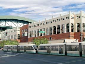
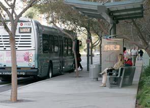
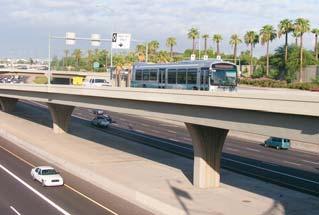
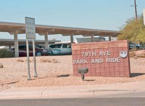
2 INTRODUCTION Cricket Pavilion Study Description, Project Background The Federal Transit Administration (FTA) and METRO are conducting an 18-month study to analyze potential high capacity transit improvements in west Phoenix and portions of Tolleson. In order to qualify for federal funding the study follows a process known as an Alternatives Analysis. The alternatives analysis is the first stage of the transit planning process required by the FTA. During the course of the study, several potential transit technologies and alignments that could be implemented in the study area will be examined. Upon completion of the alternatives analysis, environmental documentation will be completed according to the National Environmental Policy Act and FTA guidance. The study includes a public involvement component designed to get community feedback, share project details, and ascertain community desires regarding potential high capacity transit service improvements. This will help METRO identify the route and transit technology that will provide the best transportation choices for Phoenix, Tolleson, and West Valley residents. The I-10 West Study is funded by the Proposition 400 half-cent transportation sales tax extension approved by Maricopa County voters in 2004, and is contained in the adopted Regional Transportation Plan as a component of the 57 miles of a high capacity transit / light rail network to be implemented by 2026 (Figure 1). The 20-mile light rail starter line now under construction runs through Phoenix, Tempe and Mesa, and will open for passenger service in December The I-10 West study will evaluate possible connections to the starter line in the downtown Phoenix area. High capacity transit improvements in the I-10 West study area are anticipated to be complete in Other high capacity / light rail corridors are scheduled for implementation as follows: lation will more than triple by 2030, with employment expected to be five times greater. In fact, West Valley cities are expected to be responsible for more than 30 percent of the Valley s population growth and more than 23 percent of employment growth over the next 25 years. The I-10 corridor within the study area is one of the most heavily traveled freeways in the Phoenix metropolitan area. The I-10 Freeway is extremely congested during the morning and evening peak travel periods. Coupled with the increasing volume and associated congestion on parallel arterials such as Buckeye Road, Van Buren Avenue, McDowell Road and Thomas Road, the transportation system fails to meet existing demand. Continued population growth will only contribute to that congestion. Transit services in the study area are limited. One of the highest-volume bus routes in the system is the West Thomas Road Green Line running between Central Avenue and the Loop Freeway. The new Bus Rapid Transit service operating along the RAPID I-10 West route has been successful, serving more than 900 riders a day. State Capitol Downtown Phoenix Northwest Extension Phase I opens in 2012 Northwest Extension Phase II opens in 2017 Tempe South opens in 2015 Central Mesa opens in 2015 Glendale opens 2017 Northeast opens in 2025 Additional travel options are necessary within the study area to relieve congestion. ADOT is beginning to evaluate options for widening I-10 West of I-17 with construction currently programmed for fiscal year The alternatives analysis process will require coordination with ADOT to determine future alternatives. 79th Avenue Park-n-Ride The West Valley, which includes the cities of Goodyear, Buckeye, Tolleson, Avondale, Litchfield Park, Surprise, El Mirage, Youngtown, and portions of unincorporated Maricopa County (including Sun City), encompass the area influencing travel to and from the I-10 West study area. The study area is bounded by the Loop Freeway on the west, Seventh Street on the east, Thomas Road on the north and Buckeye Road on the south (Figure 2). Projections by the Maricopa Association of Governments predict that the West Valley popu- Even with implementation of the projects included in the MAG Regional Transportation Plan, the level of service in 2030 on both the freeways and arterials is expected to deteriorate significantly because of increased demand. The result is a significant increase in congestion. The alternatives analysis will look at the potential for high-capacity transit improvements to address part of this demand by connecting the study corridor with the light rail starter line on Central Avenue.
3 STUDY PURPOSE Identify a transit alternative that improves efficient access to employment opportunities throughout the Central Phoenix/ West Valley region. Identify an improvement that provides transit options to relieve peak period congestion. Identify a transit improvement alternative, with a recommended alignment and technology, to connect the METRO light rail system with the West Valley. Identify a transit alternative that will facilitate continued development of a comprehensive and inter-connected regional transit network that is multi-modal, that offers a range of choices for current and future transit riders, and that attracts new transit riders to the regional system. THE SCOPING PROCESS Scoping is a study process designed to inform the public interest groups and participating agencies about the proposed project, potential alternatives under consideration, and issues needing review and input. The goal is to encourage early and active participation in the decision-making process. The scoping process defines the alternative routes and alignments that will be examined in the study, identifies potential impacts that could arise from implementation of each alternative under consideration, and establishes the goals and objectives that will guide the evaluation of the alternatives. Citizens, agencies and community organizations are encouraged to comment early in the process in order to help guide the direction of the study, including defining project goals and objectives and identifying issues and impacts. Figure 2 I-10 WEST STUDY AREA Figure 1 REGIONAL TRANSPORTATION PLAN TRANSIT CORRIDORS Beardsley Rd Bell Rd Thunderbird Rd Peoria Ave Northern Ave Bethany Home Rd Indian School Rd McDowell Rd Buckeye Rd Broadway Rd Baseline Rd 99th Ave Peoria 83rd Ave Glendale 10 67th Ave 51st Ave South 35th Ave 17 Phoenix Phoenix 19th Ave Central Ave Light Rail Starter Line / Station City of Phoenix City of Tolleson th St 202 Mountain Freeway th St Paradise Valley th St Scottsdale 2015 Tempe Rural Rd LEGEND Chaparral Rd Chandler Santan Freeway Price Rd Alma School Rd Thomas Rd McQueen Rd Mesa Gilbert Rd Gilbert Val Vista Dr LEGEND Initial 20-mile Light Rail Alignment (Scheduled to open Dec. 2008) Northwest Extension Phase 1 (Scheduled to open 2012) Future High Capacity / Light Rail Corridors for Further Study I-10 West Corridor Note: Dates indicate calendar year openings McKellips Rd University Dr Southern Ave Guadalupe Rd Warner Rd Chandler Blvd Germann Rd Unincorporated Maricopa County Landmark Railroad Identify an alternative that improves the efficiency of transit operations. Identify an alternative that provides cost-effective transit improvements and expands access to corridor destinations. Identify a transit alternative that supports economic development, including transit-oriented development, and ensures connectivity among existing and planned activity centers and attractions. Thomas Rd McDowell Rd Van Buren St UPRR Buckeye Rd 99th Ave Univ. of Phoenix 91st Ave Downtown Tolleson 83rd Ave 75th Ave Desert Sky Mall Cricket Pavilion 79th Avenue Park-n-Ride 67th Ave 59th Ave 51st Ave 43rd Ave 10 35th Ave Beth El & Greenwood Memory Lawn Cemeteries 27th Ave Encanto Park and Golf Course 17 BNSF 19th Ave State Fairgrounds City State Hall Capitol Maricopa. County.Admin. 7th Ave Central Ave Arts District Downtown Phoenix 7th St
 and with the FTA/Federal Highway Administration regulations Environmental Impact and Related Procedures (23 CFR Part 771).")

; The Section 404(b)(1) guidelines of EPA (40 CFR part 230); The regulation implementing Section 106 of the National Historic Preservation Act (36 CFR")
; and Executive orders 12898 on environmental justice, 11988 on floodplain management and 11990 on wetlands.")
4 PROJECT DEVELOPMENT PROCESS The Alternatives Analysis/Environmental Impact Statement will be prepared in accordance with National Environmental Policy Act and its implementing regulations issued by the Council on Environmental Quality (40 CFR Parts ) and with the FTA/Federal Highway Administration regulations Environmental Impact and Related Procedures (23 CFR Part 771). In accordance with 23 CFR (a) and , FTA will comply with all Federal environmental laws, regulations, and executive orders applicable to the proposed project during the environmental review process to the maximum extent practicable. These requirements include, but are not limited to: The project-level air quality conformity regulation of the U.S. Environmental Protection Agency (40 CFR part 93); The Section 404(b)(1) guidelines of EPA (40 CFR part 230); The regulation implementing Section 106 of the National Historic Preservation Act (36 CFR part 800); The regulation implementing Section 7 of the Endangered Species Act (50 CFR part 402); Section 4(f) of the Department of Transportation Act (23 CFR ); and Executive orders on environmental justice, on floodplain management and on wetlands. Other Alternatives At a minimum, the alternatives to be considered include the following: No-build. Implements modified existing and committed road and transit improvements as defined by the Regional Transportation Plan and coordinated with the cities of Phoenix and Tolleson. Transportation System Management. Cost-effective transit service improvements short of a major capital investment in a fixed guideway. This alternative implements all of the projects in the no-build alternative. Build alternatives. All build alternatives will include the projects contained in the no-build alternative and the highway element of the Transportation System Management alternatives. Technologies would include: 35th - 39th Avenue PROJECT DEVELOPMENT PROCESS The Alternatives Analysis/Environmental Impact Statement will be prepared in accordance with National Environmental Policy Act and its implementing regulations issued by the Council on Environmental Quality (40 CFR Parts ) and with the FTA/Federal Highway Administration regulations Environmental Impact and Related Procedures (23 CFR Part 771). In accordance with 23 CFR (a) and , FTA will comply with all Federal environmental laws, regulations, and executive orders applicable to the proposed project 5th Street Off Ramp The environmental and public hearing provisions of Federal transit laws (49 U.S.C. 5301(e), 5323(b), and 5324); Downtown Phoenix and State Capitol Alternatives under Consideration A range of transit modes and alignment alternatives will be evaluated for the corridor. Modal alternatives would include both light rail and bus rapid transit technologies operating in exclusive guideway. Project alternatives will also include the consideration of express buses operating in High Occupancy Vehicle lanes on I- 10 and alternatives that are developed through the project scoping process. Express Bus in HOV lanes Bus Rapid Transit in HOV or exclusive lanes Light Rail Transit 7th Avenue Bridge The preliminary set of alignment alternatives will be oriented along the I-10 Freeway rightof-way or other major roadways into downtown Phoenix. Alignment alternatives along the major east-west arterials such as Buckeye Road, Van Buren Avenue, McDowell Road and Thomas Road will be considered. East of I-17, alignment alternatives will need to follow city streets to make connections to the downtown Phoenix transit facilities including the downtown Phoenix Transit Center and the Central Phoenix/East Valley light rail line.


5 Rapid Transit METRO Light Rail Orange Line in Los Angeles, California TRANSIT TECHNOLOGIES Transit technologies under consideration are Bus Rapid Transit, Light Rail operating in exclusive guideway and Express Bus in HOV Lanes. Bus Rapid Transit Bus Rapid Transit is a limited-stop bus service developed in the 1990s that relies on technology to help provide speedier service and travel times. BRT can operate on exclusive transit corridors, in HOV lanes, on expressways or in mixed traffic on city streets. A BRT line combines intelligent transportation systems technology, priority for transit, convenient fare collection and integration with land use policy in order to substantially upgrade bus system performance. The Orange Line in California is one example. These features characterize Bus Rapid Transit: Exclusive busway or HOV/limited travel lanes Busways are special lanes designed for the exclusive use of buses. Use of HOV lanes can improve service for long-distance commuters. Traffic Signal Priority Traffic signals are designed to give preference to buses. As the bus travels along its route, electronic sensors cause traffic signals to shorten or eliminate intersection wait times for buses. Boarding and Fare Collection Improvements Rapid fare collection through prepaid or electronic passes and low-floor/wide-door boarding results in time savings. Level boarding and precision docking may be a feature of BRT, similar to light rail and street car operations. Improved Stations and Shelters Bus terminals and unique stations or shelters differentiate BRT service from standard bus service. Intelligent Transportation Systems Technologies Advanced technology can maintain more consistent distances between buses and inform passengers when the next bus is arriving. Streamlined vehicles Improved vehicles offer a variety of seating options, easier boarding, smoother rides, and greater appeal to the riding public. Light Rail Light rail features single cars or multi-car trains (up to three vehicles). Light rail is powered by electrified overhead wires, allowing light rail to travel alongside mixed vehicle traffic and pedestrians, typically in a semi-exclusive right-of-way. Light rail can operate on tracks embedded in the street, on at-grade rights-ofway with street and pedestrian crossings, and on exclusive rights-of-way. Light rail stations are typically spaced a half-mile to one mile apart. Top speed is 55 miles per hour, with average speeds of miles per hour. Vehicles generally carry 175 passengers; light rail has the highest passenger carrying capacity of all of the transit modes. The ride is very smooth and quiet. Examples of light rail are the METRO 20- mile starter line in the Valley, the Portland MAX, and Dallas DART system. Express Bus in HOV Lanes Express Bus operating in high occupancy vehicle lanes on I-10 will be considered as a project alternative. Characteristics of Express Bus include limited service stops and vehicles typically designed and intended for longerdistance commuters. Limited Stops Increasing distances between stations or shelters increases speeds. Valley Metro in Phoenix, AZ


 254-7245/ TTY (602)")
6 OPPORTUNITIES FOR PUBLIC INVOLVEMENT Opportunities for community input will occur at each important milestone as the study progresses. If you have questions or want more information on how to provide input you are encouraged to contact METRO. PROJECT HOTLINE RAIL WEBSITE MetroLightRail.org/I-10West MetroLightRail.org To receive this information in alternative formats call (602) / TTY (602) Para recibir esta información en formatos alternativos favor de llamar al /TTY
CENTRAL MESA HIGH C CENTRAL MESA HIGH CAPACIT CIT Y TRANSIT C TRANSIT CORRIDOR ORRIDOR
 CENTRAL MESA HIGH CAPACITY TRANSIT CORRIDOR study SCOPING BROCHURE INTRODUCTION Study Description, Project Background METRO and the City of Mesa are conducting a 24-month study to analyze potential high
I-10 West AA/EIS Pre-Screening and Tier 1 Analysis Results. Public Meeting. Wulf Grote, Director Project Development Rick Pilgrim, Project Manager
 I-10 West AA/EIS Pre-Screening and Tier 1 Analysis Results Public Meeting Wulf Grote, Director Project Development Rick Pilgrim, Project Manager March 4 & 5, 2008 Today s Agenda Overview of Alternatives
Executive Summary. Draft Environmental Impact Statement/Environmental Impact Report ES-1
 Executive Summary Introduction The Eastside Transit Corridor Phase 2 Project is a vital public transit infrastructure investment that would provide a transit connection to the existing Metro Gold Line
LOS ANGELES COUNTY METROPOLITAN TRANSPORTATION AUTHORITY (LACMTA) AND FEDERAL TRANSIT ADMINISTRATION (FTA)
 AND FEDERAL TRANSIT ADMINISTRATION (FTA)") LOS ANGELES COUNTY METROPOLITAN TRANSPORTATION AUTHORITY (LACMTA) AND FEDERAL TRANSIT ADMINISTRATION (FTA) NOTICE OF PREPARATION (NOP)/NOTICE OF INTENT (NOI) OF AN ENVIRONMENTAL IMPACT STATEMENT (EIS)/ENVIRONMENTAL
LOS ANGELES COUNTY METROPOLITAN TRANSPORTATION AUTHORITY (LACMTA) AND FEDERAL TRANSIT ADMINISTRATION (FTA) NOTICE OF PREPARATION (NOP)/NOTICE OF INTENT (NOI) OF AN ENVIRONMENTAL IMPACT STATEMENT (EIS)/ENVIRONMENTAL
Kendall Drive Premium Transit PD&E Study Project Kick-Off Meeting SR 94/Kendall Drive/SW 88 Street Project Development and Environment (PD&E) Study
 Study") Florida Department of Transportation District Six Kendall Drive Premium Transit PD&E Study Project Kick-Off Meeting SR 94/Kendall Drive/SW 88 Street Project Development and Environment (PD&E) Study What
Florida Department of Transportation District Six Kendall Drive Premium Transit PD&E Study Project Kick-Off Meeting SR 94/Kendall Drive/SW 88 Street Project Development and Environment (PD&E) Study What
Executive Summary. Treasure Valley High Capacity Transit Study Priority Corridor Phase 1 Alternatives Analysis October 13, 2009.
 Treasure Valley High Capacity Transit Study Priority Corridor Phase 1 Alternatives Analysis October 13, 2009 Background As the Treasure Valley continues to grow, high-quality transportation connections
EUGENE-SPRINGFIELD, OREGON EAST WEST PILOT BRT LANE TRANSIT DISTRICT
 EUGENE-SPRINGFIELD, OREGON EAST WEST PILOT BRT LANE TRANSIT DISTRICT (BRIEF) Table of Contents EUGENE-SPRINGFIELD, OREGON (USA)... 1 COUNTY CONTEXT AND SYSTEM DESCRIPTION... 1 SYSTEM OVERVIEW... 1 PLANNING
Develop ground transportation improvements to make the Airport a multi-modal regional
 Project Overview TRANSPORTATION IMPROVEMENTS WHAT ARE THE PROJECT GOALS? Transportation transportation hub. Develop ground transportation improvements to make the Airport a multi-modal regional Land Use
Restoration of Historic Streetcar Services in Downtown Los Angeles
 Restoration of Historic Streetcar Services in Downtown Los Angeles Alternatives Analysis Community Update Meeting August 2, 2011 Introduction Key players Local lead agency: Metro Federal lead agency: Federal
Pacific Electric Right-of-Way / West Santa Ana Branch Corridor Alternatives Analysis
 Pacific Electric Right-of-Way / West Santa Ana Branch Corridor Alternatives Analysis Transit Coalition September 26, 2012 2 Study Area Pacific Electric Rightof-Way/West Santa Ana Branch (PEROW/ WSAB) extends
RECOMMENDED ALTERNATIVE REPORT
 DRAFT METROCENTER CORRIDOR STUDY RECOMMENDED ALTERNATIVE REPORT JULY 12, 2005 TABLE OF CONTENTS SECTION PAGE 1.0 INTRODUCTION... 1 2.0 TIER 1 ALTERNATIVES EVALUATION... 1 3.0 TIER 2 ALTERNATIVES EVALUATION...
Leadership NC. November 8, 2018
 v Leadership NC November 8, 2018 Planning for our region s growth The Triangle is one of the fastestgrowing regions in the nation. More than 2 million people are already part of the equation, and the
5. OPPORTUNITIES AND NEXT STEPS
 5. OPPORTUNITIES AND NEXT STEPS When the METRO Green Line LRT begins operating in mid-2014, a strong emphasis will be placed on providing frequent connecting bus service with Green Line trains. Bus hours
CMAQ DETAILED PROJECT LISTING REPORT ( FY 2000 )
") Fiscal Year = 'By Fiscal Year' and Status Selection Criteria = 'All' and State = '' 1/10/2003 $35,636,011 $35,129,118 99 $910,000 Demand Management Trip Reduction Program Demand Management Project - New
Fiscal Year = 'By Fiscal Year' and Status Selection Criteria = 'All' and State = '' 1/10/2003 $35,636,011 $35,129,118 99 $910,000 Demand Management Trip Reduction Program Demand Management Project - New
Valley Metro Overview. ITE/IMSA Spring Conference March 6, 2014
 Valley Metro Overview ITE/IMSA Spring Conference March 6, 2014 Valley Metro Who Are We? Operate Regional Transit Services Valley Metro and Phoenix are region s primary service providers Light Rail and
CEDAR AVENUE TRANSITWAY Implementation Plan Update
 CEDAR AVENUE TRANSITWAY Implementation Plan Update EECUTIVE SUMMARY DECEMBER 2015 Executive Summary In 2013, the Twin Cities metropolitan area s first bus rapid transit (BRT) line, the METRO Red Line,
Restoration of Historic Streetcar Services in Downtown Los Angeles
 Restoration of Historic Streetcar Services in Downtown Los Angeles Early Scoping Meeting for Alternatives Analysis (AA) May 17, 2011 Introduction Key players Local lead agency: Metro Federal lead agency:
Valley Metro: Past, Present and Future. September 11, 2014
 Valley Metro: Past, Present and Future September 11, 2014 Valley Metro Who are We? Two Boards of Directors Regional Public Transportation Authority Fund and operate regional transit services Valley Metro
DRAFT METROCENTER CORRIDOR STUDY
 DRAFT METROCENTER CORRIDOR STUDY TIER 2 EVALUATION OF ALTERNATIVES JUNE 20, 2005 TABLE OF CONTENTS SECTION PAGE 1.0 INTRODUCTION... 1 1.1 Overview... 1 1.2 Project Description... 1 2.0 EVALUATION PROCESS...
PRIME SITE AT PRESTIGIOUS SCOTTSDALE RD INTERSECTION
 CITRUS RD. Southeast Corner of Loop 101 & Scottsdale Road - Scottsdale, Arizona ESTRELLA FWY. 303 REEMS RD. SUN CITY WEST THUNDERBIRD RD. OLIVE AVE. GLENDALE AVE. LITCHFIELD RD. DYSART RD. BROADWAY RD.
FREQUENTLY ASKED QUESTIONS
 FREQUENTLY ASKED QUESTIONS 2018 What is the More MARTA Atlanta program? The More MARTA Atlanta program is a collaborative partnership between MARTA and the City of Atlanta to develop and implement a program
4.0 TIER 2 ALTERNATIVES
 4.0 TIER 2 ALTERNATIVES The Tier 2 Alternatives represent the highest performing Tier 1 Alternatives. The purpose of the Tier 2 Screening was to identify the LPA utilizing a more robust list of evaluation
METRO Light Rail Update
 American Society of Highway Engineers METRO Light Rail Update Brian Buchanan Director, Design and Construction October 13, 2009 1 High Capacity Transit System 2 20-Mile Light Rail Line 3 Operations Operations
I-820 (East) Project Description. Fort Worth District. Reconstruct Southern I-820/SH 121 Interchange
 Project Description. Fort Worth District. Reconstruct Southern I-820/SH 121 Interchange") I-820 (East) Project Description Fort Worth District Reconstruct Southern I-820/SH 121 Interchange I-820 from approximately 2,000 feet north of Pipeline Road/Glenview Drive to approximately 3,200 feet
I-820 (East) Project Description Fort Worth District Reconstruct Southern I-820/SH 121 Interchange I-820 from approximately 2,000 feet north of Pipeline Road/Glenview Drive to approximately 3,200 feet
Preliminary Definition of Alternatives. 3.0 Preliminary Definition of Alternatives
 3.0 What preliminary alternatives are being evaluated? The alternatives for the East San Fernando Valley Transit Corridor project that were considered for screening include the No Build Alternative, Transportation
Chapter 4 : THEME 2. Transportation
 Chapter 4 : THEME 2 Strengthen connections to keep the Central Area easy to reach and get around 55 Figure 4.2.1 Promote region-wide transit investments. Metra commuter rail provides service to the east,
Help shape your community investment in Wake Transit. Fiscal Year 2019 Draft Work Plan Summary
 Help shape your community investment in Wake Transit Fiscal Year 2019 Draft Work Plan Summary Wake County, growth and transit The Triangle is one of the fastest-growing regions in the nation. Wake County
Tempe Streetcar. March 2, 2016
 Tempe Streetcar March 2, 2016 Tempe Profile 40 sq. miles, highest density in state University Town, center of region Imposed growth boundaries (density increase) Mixed use growth/intensifying land use
Energy Technical Memorandum
 Southeast Extension Project Lincoln Station to RidgeGate Parkway Prepared for: Federal Transit Administration Prepared by: Denver Regional Transportation District May 2014 Table of Contents Page No. Chapter
Click to edit Master title style
 Nelson/Nygaard Consulting Associates SERVICE IMPROVEMENT STRATEGIES September 22, 2015 1 PROJECT OVERVIEW & WORK TO DATE 1. Extensive stakeholder involvement Throughout 2. System and market assessment
3.15 SAFETY AND SECURITY
 3.15 SAFETY AND SECURITY Introduction This section describes the environmental setting and potential effects of the alternatives analyzed in this EIR with regard to safety and security in the SantaClara-Alum
East San Fernando Valley Transit Corridor. TAC Briefing December 4, 2013
 East San Fernando Valley Transit Corridor TAC Briefing December 4, 2013 Overview Measure R Project Long Range Transportation Plan Reserves $170.1 Million 2018 Revenue Operations Date Coordination with
Mountainland Association of Governments SPRINGVILLE-SPANISH FORK AREA TRANSPORTATION STUDY APRIL 2012
 Mountainland Association of Governments SPRINGVILLE-SPANISH FORK AREA TRANSPORTATION STUDY APRIL 2012 PLANNING FOR OUR FUTURE Planners with the Mountainland Association of Governments (MAG) have evaluated
Chapter 7: Travel Demand Analysis. Chapter 8. Plan Scenarios. LaSalle Community Center. Image Credit: Town of LaSalle
 Chapter 7: Travel Demand Analysis Chapter 8 Plan Scenarios LaSalle Community Center. Image Credit: Town of LaSalle 164 Chapter 8: Plan Scenarios Moving Ahead for Progress in the 21 st Century Act (MAP
Northeast Corridor Alternatives Analysis. Public Involvement Round 2 Input on Alternatives for Further Study
 Northeast Corridor Alternatives Analysis Public Involvement Round 2 Input on Alternatives for Further Study Feb. 7-9, 2012 Agenda Review project background Progress summary Recommended alternatives for
Charlotte-Mecklenburg Region Rapid Transit and Land-Use Integration
 Charlotte-Mecklenburg Region Rapid Transit and Land-Use Integration Legislative Committee on Urban Growth and Infrastructure Carolyn Flowers CEO Charlotte Area Transit System March 23, 2010 Charlotte Region
Harlem Avenue between 63 rd and 65 th
 Harlem Avenue between 63 rd and 65 th Public Meeting #2 March 13, 2018 Summit Park District Welcome to the second Public Meeting for the preliminary engineering and environmental studies of Illinois 43
Service Quality: Higher Ridership: Very Affordable: Image:
 Over the past decade, much attention has been placed on the development of Bus Rapid Transit (BRT) systems. These systems provide rail-like service, but with buses, and are typically less expensive to
Rapid Transit and Land-Use Integration a Reality
 City of Charlotte Rapid Transit and Land-Use Integration a Reality Transportation Oversight Committee Carolyn Flowers CEO Charlotte Area Transit System April 29, 2010 Charlotte Region Statistics Mecklenburg
BROWARD BOULEVARD CORRIDOR TRANSIT STUDY
 BROWARD BOULEVARD CORRIDOR TRANSIT STUDY FM # 42802411201 EXECUTIVE SUMMARY July 2012 GOBROWARD Broward Boulevard Corridor Transit Study FM # 42802411201 Executive Summary Prepared For: Ms. Khalilah Ffrench,
Maryland Gets to Work
 I-695/Leeds Avenue Interchange Reconstruction Baltimore County Reconstruction of the I-695/Leeds Avenue interchange including replacing the I-695 Inner Loop bridges over Benson Avenue, Amtrak s Northeast
Chapter 7. Transportation Capital Improvement Projects. Chapter 7
 Chapter 7 Transportation Capital Improvement Projects Chapter 7 81 Chapter 7 Transportation Capital Improvement Projects Local Transportation Sales Tax Programs For over three decades, Santa Clara County
Operating & Maintenance Cost Results Report
 Operating & Maintenance Cost Results Report Prepared for: Hennepin County Regional Railroad Authority Prepared by: Connetics Transportation Group Under Contract To: Kimley-Horn and Associates FINAL June
SCOPING SUMMARY REPORT
 DRAFT METROCENTER CORRIDOR STUDY SCOPING SUMMARY REPORT February 12, 2004 TABLE OF CONTENTS SECTION PAGE 1.0 INTRODUCTION...1 1.1 Overview...1 1.2 Purpose...1 1.3 Process...2 2.0 PROJECT BACKGROUND...2
6/6/2018. June 7, Item #1 CITIZENS PARTICIPATION
 June 7, 2018 Item #1 CITIZENS PARTICIPATION 1 Item #2 APPROVAL OF MINUTES Item #3 TRAC GOALS, FRAMEWORK & AGENDA REVIEW 2 COMMITTEE GOALS Learn about Southern Nevada s mobility challenges, new developments
METRO Orange Line BRT American Boulevard Station Options
 METRO Orange Line BRT American Boulevard Station Options Bloomington City Council Work Session November 18, 2013 Christina Morrison BRT/Small Starts Project Office Coordinating Planning and Design AMERICAN
Public Information Workshop
 Public Information Workshop Charlotte County-Punta Gorda MPO - Meeting Rooms A and B March 29, 2018 Welcome to the Public Information Workshop for Harborview Road Project Development and Environment (PD&E)
Public Meeting. June 15, :30 7:30 p.m.
 Public Meeting June 15, 2017 5:30 7:30 p.m. Welcome 2015 Naval Station Norfolk Transit Extension Study 2015 Naval Station Norfolk Transit Extension Study 2017 Norfolk Westside Transit Study HRT and the
EAST LINK PROJECT. Environmental Scoping Information Report. Seattle to Bellevue to Redmond. September 2006
 SCOPING EAST LINK PROJECT Environmental Scoping Information Report Seattle to Bellevue to Redmond September 2006 CENTRAL PUGET SOUND REGIONAL TRANSIT AUTHORITY TABLE OF CONTENTS Introduction... 2 What
HOT Lanes: Congestion Relief and Better Transit
 HOT Lanes: Congestion Relief and Better Transit Robert W. Poole, Jr. Director of Transportation Studies Reason Foundation www.reason.org/transportation Basic Thesis: Current Transportation Plans Need Rethinking
Waco Rapid Transit Corridor (RTC) Feasibility Study
 Feasibility Study") Waco Rapid Transit Corridor (RTC) Feasibility Study Chris Evilia, Director of Waco Metropolitan Planning Organization Allen Hunter, General Manager Waco Transit System Jimi Mitchell, Project Manager AECOM
Waco Rapid Transit Corridor (RTC) Feasibility Study Chris Evilia, Director of Waco Metropolitan Planning Organization Allen Hunter, General Manager Waco Transit System Jimi Mitchell, Project Manager AECOM
Rocky Mount. Transportation Plan. Transportation Planning Division. Virginia Department of Transportation
 2020 Transportation Plan Developed by the Transportation Planning Division of the Virginia Department of Transportation in cooperation with the U.S. Department of Transportation, Federal Highway Administration
Metropolitan Council Budget Overview SFY
 Metropolitan Council Budget Overview SFY 2016-2017 H T t ti C itt House Transportation Committee February 4, 2015 Transit connects us to the places that matter Transportation Needs Grow as the Region Grows
Project Scoping Report Appendix B Project Web Site. APPENDIX B Project Web Site
 Project Scoping Report Appendix B Project Web Site APPENDIX B Project Web Site WESTSIDE EXTENSION TRANSIT CORRIDOR STUDY February 4, 2008 News and Info of 1 http://metro.net/projects_programs/westside/news_info.htm#topofpage
Parking Management Element
 Parking Management Element The State Transportation Planning Rule, adopted in 1991, requires that the Metropolitan Planning Organization (MPO) area implement, through its member jurisdictions, a parking
Needs and Community Characteristics
 Needs and Community Characteristics Anticipate Population and Job Growth in the City Strongest density of population and jobs in Ann Arbor are within the Study Area Population expected to grow 8.4% by
MOTION NO. M Preferred Alternative for the Puyallup Station Access Improvement Project
 MOTION NO. M2014 64 Preferred Alternative for the Puyallup Station Access Improvement Project MEETING: DATE: TYPE OF ACTION: STAFF CONTACT: Capital Committee Board PROPOSED ACTION 8/14/14 8/28/14 Recommendation
A Transit Plan for the Future. Draft Network Plan
 A Transit Plan for the Future Draft Network Plan Project Overview and Status Completed Market Analysis and Service Evaluation. Developed Plan Framework and Guiding Principles. Developed a draft Five Year
REPORT CARD FOR CALIFORNIA S INFRASTRUCTURE WHAT YOU SHOULD KNOW ABOUT CALIFORNIA S TRANSIT FACILITIES
 TRANSIT GRADE: C- WHAT YOU SHOULD KNOW ABOUT TRANSIT FACILITIES California needs robust, flexible and reliable transit systems to reduce peak congestion on our highways, provide options for citizens who
VAN NESS AVENUE BUS RAPID TRANSIT
 VAN NESS AVENUE BUS RAPID TRANSIT Commission of the Environment Policy Committee May 22, 2014 Peter Gabancho Project Manager III Capital Programs & Construction SFMTA 1 Conceptual Visual Simulation Center-Running
I-26 Fixed Guideway Alternatives Analysis
 I-26 Fixed Guideway Alternatives Analysis Public Meetings: North Charleston, January 25, 2016 Charleston: January 26, 2016 Summerville: January 28, 2016 Agenda I. Project Update II. III. IV. Screen Two
SERVICE DESIGN GUIDELINES
 VTA TRANSIT SUSTAINABILITY POLICY: APPENDIX A SERVICE DESIGN GUIDELINES Adopted February 2007 COMMUNITYBUS LOCALBUS EXPRESSBUS BUSRAPIDTRANSIT LIGHTRAILTRANSIT STATIONAREAS S A N T A C L A R A Valley Transportation
Feasibility Study. Community Meeting March, North-South Commuter Rail Feasibility Study
 Feasibility Study Community Meeting March, 2017 1 Agenda 1. Welcome / Introductions 2. Background / Meeting Purpose 3. Progress to Date Options Evaluated Capital/Operating Costs Ridership 4. Financial
Public Meeting. City of Chicago Department of Transportation & Department of Housing and Economic Development
 Public Meeting City of Chicago Department of Transportation & Department of Housing and Economic Development Funded by Regional Transportation Authority September 12, 2011 In partnership with Presentation
Independence Institute Denver West Parkway, Suite 185 Golden, Colorado i2i.org/cad.aspx BRT = BTR
 Independence Institute 14142 Denver West Parkway, Suite 185 Golden, Colorado 80401 303-279-6536 i2i.org/cad.aspx BRT = BTR Bus-Rapid Transit Is Better Than Rail: The Smart Alternative to Light Rail Joseph
West Broadway Reconstruction/LRT Design. March 19, 2015
 West Broadway Reconstruction/LRT Design March 19, 2015 1 Meeting Agenda 6:05 6:30 PM Brief presentation What we heard Project overview 6:30 8:00 PM Visit Six Topic Areas Road and LRT design elements Pedestrian
KANSAS CITY STREETCAR
 KANSAS CITY STREETCAR KAREN CLAWSON MID-AMERICA REGIONAL COUNCIL KANSAS CITY STREETCAR Regional Context Alternatives Analysis Kansas City Streetcar Project KANSAS CITY REGION KANSAS CITY REGION KANSAS
US 29 Bus Rapid Transit Planning Board Briefing. February 16, 2017
 US 29 Bus Rapid Transit Planning Board Briefing February 16, 2017 Project Goals Improve the quality of transit service Improve mobility opportunities and choices Enhance quality of life Support master
Transit Access Study
 West of Hudson Regional Transit Access Study Open House presentation July 20, 2010 1 Agenda Progress To date Summary of Level 2 Alternatives and Screening Service Plans Bus and Rail Operating and Capital
What is the Connector?
 What is the Connector? The Connector is a plan for a high-capacity transit system from northeast to south Ann Arbor, connecting major destinations including downtown, commercial, and residential areas,
West Broadway Transit Study. Community Advisory Committee September 17, 2015
 West Broadway Transit Study Community Advisory Committee September 17, 2015 Introductions Community Engagement Summer Outreach Fall Outreach Technical Analysis Process Update Alternatives Review Economic
Point A Point B Point C Point D. Fulton County Board of Commissioners and Mayors Meeting December 14, 2017
 Fulton County Board of Commissioners and Mayors Meeting December 14, 2017 Master Plan Overview Phase 1 Community Vision and Existing Transit Conditions Phase 2 Scenario Development Phase 3 Transit Master
Draft Results and Open House
 Waco Rapid Transit Corridor (RTC) Feasibility Study Draft Results and Open House Chris Evilia, Director of Waco Metropolitan Planning Organization Allen Hunter, General Manager Waco Transit System Jimi
Bi-County Transitway/ Bethesda Station Access Demand Analysis
 Bi-County Transitway/ Bethesda Station Access Demand Analysis Prepared for: Washington Metropolitan Area Transit Authority Office of Planning and Project Development May 2005 Prepared by: in conjunction
Office of Transportation Bureau of Traffic Management Downtown Parking Meter District Rate Report
 Office of Transportation Bureau of Traffic Management 1997 Downtown Parking Meter District Rate Report Introduction The City operates approximately 5,600 parking meters in the core area of downtown. 1
THE WILSHIRE CORRIDOR: RAIL AND ITS ALTERNATIVES. Prepared By: Jacki Murdock Transportation and Environmental Planner
 THE WILSHIRE CORRIDOR: RAIL AND ITS ALTERNATIVES Prepared By: Jacki Murdock Transportation and Environmental Planner December 13 th, 2012 Overview Characteristics of Wilshire Boulevard Overview of the
I-20 EAST TRANSIT INITIATIVE Tier 1 and Tier 2 Alternatives Screening Report EXECUTIVE SUMMARY
 EXECUTIVE SUMMARY The purpose of this report is to document the results of the Tier 1 and Tier 2 Screening of alternatives for the I-20 East Transit Initiative. The two-tier screening process presented
The Engineering Department recommends Council receive this report for information.
 CORPORATE REPORT NO: R161 COUNCIL DATE: July 23, 2018 REGULAR COUNCIL TO: Mayor & Council DATE: July 19, 2018 FROM: General Manager, Engineering FILE: 8740-01 SUBJECT: Surrey Long-Range Rapid Transit Vision
State Avenue Corridor Bus Rapid Transit (BRT)
") State Avenue Corridor Bus Rapid Transit (BRT) Moving Forward Incrementally April 2010 State Ave. BRT Update Bus Rapid Transit Overview State Ave. Alternatives Analysis Results What s Coming Up Right Away!
State Avenue Corridor Bus Rapid Transit (BRT) Moving Forward Incrementally April 2010 State Ave. BRT Update Bus Rapid Transit Overview State Ave. Alternatives Analysis Results What s Coming Up Right Away!
Sales and Use Transportation Tax Implementation Plan
 Sales and Use Transportation Tax Implementation Plan Transportation is more than just a way of getting from here to there. Reliable, safe transportation is necessary for commerce, economic development,
Welcome. Please Sign In
 Welcome South Bay Bus Rapid Transit (BRT) Draft Environmental Impact Report (DEIR) Public Meeting Please Sign In Please comment in any of the following manners: 1. Submit a comment form 2. Provide verbal
WAKE TRANSIT PLAN Summer 2018
 WAKE TRANSIT PLAN Summer 2018 Planning for growth WAKE COUNTY s population already exceeds ONE MILLION and grows by more than 60 people a day. That s 23,000 people a year or basically another Morrisville.
Attachment 5. High Speed Transit Planning Study REPORT SUMMARY. Prepared by: City of Edmonton Transportation Planning Branch. Stantec Consulting Ltd.
 Attachment 5 High Speed Transit Planning Study Prepared by: City of Edmonton Transportation Planning Branch Stantec Consulting Ltd. Transportation Management & Design, Inc. with Lea Consulting Ltd. [135-35130]
WELCOME. Transit Options Amherst - Buffalo Public Workshops
 WELCOME Transit Options Amherst - Buffalo Public Workshops Sponsored by Niagara Frontier Transportation Authority Greater Buffalo Niagara Regional Transportation Council Where do you live? Where do you
Kenosha-Racine-Milwaukee (KRM)
") Kenosha-Racine-Milwaukee (KRM) Commuter Rail #147925 November 6, 2009 1 Guidance of KRM Commuter Rail Studies Intergovernmental Partnership Technical Steering Committee Temporary and Limited Authority
Kenosha-Racine-Milwaukee (KRM) Commuter Rail #147925 November 6, 2009 1 Guidance of KRM Commuter Rail Studies Intergovernmental Partnership Technical Steering Committee Temporary and Limited Authority
2. Valley Circle Boulevard/Andora Avenue/Baden Avenue and Lassen Street
 IV.J TRANSPORTATION 1. INTRODUCTION This section presents an overview of the existing traffic and circulation system in and surrounding the project site. This section also discusses the potential impacts
Community Open Houses November 29 December 7, 2017
 Community Open Houses November 29 December 7, 2017 1 Community Open House Agenda 6:00 PM Open House 6:30-7:30 PM Presentation and Q&A 7:30-8:00 PM Open House Resumes after the presentation and Q&A Thank
Community Advisory Committee. October 5, 2015
 Community Advisory Committee October 5, 2015 1 Today s Topics Hennepin County Community Works Update Project Ridership Estimates Technical Issue #4:Golden Valley Rd and Plymouth Ave Stations Technical
Crenshaw-Prairie Transit Corridor Study Public Meetings
 Crenshaw-Prairie Transit Corridor Study Public Meetings Darby Park: Wednesday, February 20, 2008 6:30 8:00 PM US Bank Community Room: Thursday, February 21, 2008 6:30 8:00 PM Nate Holden Performing Arts
Kendall Drive Premium Transit PD&E Study
 Florida Department of Transportation District Six Kendall Drive Premium Transit PD&E Study Project Kick-Off Meeting SR 94/Kendall Drive/SW 88 Street Project Development and Environment (PD&E) Study From
Draft Results and Recommendations
 Waco Rapid Transit Corridor (RTC) Feasibility Study Draft Results and Recommendations Chris Evilia, Director of Waco Metropolitan Planning Organization Allen Hunter, General Manager Waco Transit System
Overview of Regional Commuter Rail Webinar: Phoenix, Arizona December 18, 2013
 Overview of Regional Commuter Rail Webinar: Phoenix, Arizona December 18, 2013 2013, All Rights Reserved. 1 The Maricopa Association of Governments (MAG) is the designated metropolitan planning organization
EGLINTON CROSSTOWN LIGHT RAIL TRANSIT (LRT)
") WELCOME TO OUR PUBLIC OPEN HOUSE EGLINTON CROSSTOWN LIGHT RAIL TRANSIT (LRT) Preliminary Planning for a Transit Project Assessment Open House Martin Grove Road to Pearson International Airport September
WELCOME TO OUR PUBLIC OPEN HOUSE EGLINTON CROSSTOWN LIGHT RAIL TRANSIT (LRT) Preliminary Planning for a Transit Project Assessment Open House Martin Grove Road to Pearson International Airport September
Sepulveda Pass Corridor Systems Planning Study
 Los Angeles County Metropolitan Transportation Authority Sepulveda Pass Corridor Systems Planning Study Streets and Freeways Subcommittee January 17, 2013 1 Sepulveda Pass Study Corridor Extends for 30
KRM Corridor Transit Service Options: Frequently Asked Questions
 December 2008 KRM Corridor Transit Service Options: Frequently Asked Questions by Thomas A. Rubin and Robert W. Poole, Jr. FREQUENTLY ASKED QUESTIONS 1 2 3 4 5 6 7 8 How many net new transit riders would
Metro Transit Update. Christina Morrison, Senior Planner Metro Transit BRT/Small Starts Project Office. John Dillery, Senior Transit Planner
 Metro Transit Update Christina Morrison, Senior Planner Metro Transit BRT/Small Starts Project Office John Dillery, Senior Transit Planner Metro Transit Service Development May 16, 2013 1 Transit Planning
Mississauga Bus Rapid Transit Preliminary Design Project
 Mississauga Bus Rapid Transit Preliminary Design Project PUBLIC INFORMATION CENTRE OCTOBER 2008 WELCOME The Mississauga Bus Rapid Transit (BRT) Project Thank you for attending this Public Information Centre.
residents of data near walking. related to bicycling and Safety According available. available. 2.2 Land adopted by
 2. Assessment of Current Conditions and Needs In order to prepare a plan to reach the vision desired by the residents of Texarkana, it is first necessary to ascertain the current situation. Since there
The range of alternatives has been reviewed with the RTAC Subgroup and the preliminary analysis is proceeding on the following HCT alternatives:
 Attachment 2 Boise Treasure Valley Phase 1 Alternatives Analysis August 14, 2009 Introduction The Treasure Valley High Capacity Transit Priority Corridor Phase 1 Alternatives Analysis is being prepared
TransNet Dollars Keep San Diego Moving
 TransNet Dollars Keep San Diego Moving In 1987, San Diego region voters approved the TransNet program a half-cent sales tax to fund a variety of important transportation projects throughout the region.