RECOMMENDATIONS. 7-1 Anchorage Metropolitan Area Transportation Solutions
|
|
|
- Lily Heath
- 5 years ago
- Views:
Transcription
1 RECOMMENDATIONS 7-1 Anchorage Metropolitan Area Transportation Solutions
2 2035 Metropolitan Transportation Plan 7-2
3 A Call to Action 7-3 Anchorage Metropolitan Area Transportation Solutions
4 2035 Metropolitan Transportation Plan 7-4
5 7-5 Anchorage Metropolitan Area Transportation Solutions
6 2035 Metropolitan Transportation Plan 7-6 Roads
7 Scoring Points Criterion readiness No work started Some preliminary design and/or environmental work complete Final engineering completed or nearing completion ROW purchased; ready to construct Timing of need Can wait until beyond 2035 Long-term need ( ) Needed in short term helps to complete grid system or improves facility to standards Needed in short term ( ) addresses major safety/capacity needs Logical sequencing N/A New project N/A Next logical or final phase of an existing road Functional classification Local Collector Arterial/expressway Freeway Number of modes (automobile, pedestrian, bike, transit, freight or intermodal) Single Two Three Four or more Cost/length/AADT 4th quartile 3rd quartile 2nd quartile AADT = Annual Average Daily Traffic N/A = not applicable 1st quartile (highest score) 7-7 Anchorage Metropolitan Area Transportation Solutions
8 2035 Metropolitan Transportation Plan 7-8 Criterion Scoring Points Number Name Location 2010 Cost Estimate ($ million) Readiness Timing of Need Logical Sequencing Functional Classification Cost/ Length/ AADT Multi-modal Function Total 101 Seward Hwy - Dimond Blvd to Dowling Rd Dimond Blvd to Dowling Rd $ Dowling Rd Extension - Phase II 100th Ave Extension - Minnesota Dr to C St 36th Ave/Seward Hwy Interchange Glenn Hwy - Hiland Rd to Artillery Rd (Eagle River) C St to Minnesota Dr $ Minnesota Dr to C St $ Tudor Rd to 33rd Ave $ Hiland Rd to Artillery Rd $ Muldoon Rd Interchange Glenn Hwy at Muldoon Rd $ Seward Hwy - O'Malley Rd to Dimond Blvd O'Malley Rd to Dimond Blvd $ th Ave Access Management - Spenard Rd to Denali St Spenard Rd to Denali St $ Jewel Lake Rd - Dimond Blvd to International Airport Rd Dimond Blvd to International Airport Rd $ Arctic Blvd Rehabilitation - 36th Ave to Tudor Rd 36th Ave to Tudor Rd $ Northern Lights Blvd - Lake Otis Pkwy to Bragaw St Lake Otis Pkwy to Bragaw St $ Spenard Rd Rehabilitation - Hillcrest Dr to Benson Blvd O'Malley Rd - Seward Hwy to Hillside Dr Seward Hwy Improvements (Midtown Congestion Relief) Fireweed Ln Rehabilitation - Spenard Rd to Seward Hwy Hillcrest Dr to Benson Blvd $ Seward Hwy to Hillside Dr $ rd Ave to Chester Creek $ Spenard Rd to Seward Hwy $
9 Criterion Scoring Points Number Name Location 2010 Cost Estimate ($ million) Readiness Timing of Need Logical Sequencing Functional Classification Cost/ Length/ AADT Multi-modal Function Total 116 Seward Hwy - O'Malley Rd to Rabbit Creek Rd O'Malley Rd to Rabbit Creek Rd $ Seward Hwy/92nd Ave Grade Separation Homer Dr to Brayton Dr $ Lake Otis Pkwy - Northern Lights Blvd to Debarr Rd Northern Lights Blvd to Debarr Rd $ Northern Lights Blvd - Postmark Dr to Nathaniel Ct Postmark Dr to Nathaniel Ct $ DeArmoun Rd Reconstruction - Phase II 140th Ave to Hillside Dr $ Spenard Rd Rehabilitation - Benson Blvd to Minnesota Dr Benson Blvd to Minnesota Dr $ Eagle River Rd Rehabilitation - MP 5.3 to MP 12.6 (Eagle River) Eagle River Rd, MP 5.3 to MP 12.6 $ Eklutna River Bridge Rehabilitation/Replacement (Eagle River) Abbott Rd - Lake Otis Pkwy to Birch Rd Old Glenn Hwy $ Lake Otis Pkwy to Birch Rd $ North Access to U-Med District Providence Dr to Northern Lights Blvd $ Glenn Hwy/Farm Ave Partial Interchange (Eagle River) Glenn Hwy at Farm Ave $ Artillery Rd northbound offramp to Eagle River Rd (Eagle River) Glenn Hwy to Eagle River Rd $ Farm Ave Realignment at Old Glenn Hwy (Eagle River) Winter Park Place to Old Glenn Hwy $ Eagle River Rd Rehabilitation - MP 0.0 to MP 5.3 (Eagle River) Eagle River Rd, MP 0 to Upper Terrace St (MP 5.3) $ Anchorage Metropolitan Area Transportation Solutions
10 2035 Metropolitan Transportation Plan 7-10 Criterion Scoring Points Number Name Location 2010 Cost Estimate ($ million) Readiness Timing of Need Logical Sequencing Functional Classification Cost/ Length/ AADT Multi-modal Function Total nd Ave/Academy Dr Extension - Brayton Dr to Abbott Rd Brayton Dr to Abbott Rd $ Mountain Air Dr - Rabbit Creek Rd to E 164th Ave Rabbit Creek Rd to E 164th Ave $ Northwood Dr Extension - Strawberry Rd to Dimond Blvd Strawberry to Dimond Blvd $ Business Blvd Extension (Eagle River) Business Blvd to Eagle River Rd at Artillery Rd $ Homestead Rd Improvements (Eagle River) Short-Term MTP Element Implementation s Oberg Rd to Voyles Blvd $ AMATS area $6.0 N/A N/A N/A N/A N/A N/A rd Ave,6th Ave Couplet/E St Conversion Reconnaissance Study L St to Ingra-Gambell Couplet/3rd Ave to 4th Ave $0.5 N/A N/A N/A N/A N/A N/A Glenn Hwy Operations Analysis - Muldoon Rd to Eklutna Midtown Subarea Transportation Plan Muldoon Rd to Eklutna $5.6 N/A N/A N/A N/A N/A N/A 0 Midtown area $0.8 N/A N/A N/A N/A N/A N/A Seward Hwy/O'Malley Rd Interchanges Study Old Seward Hwy to Seward Hwy $0.5 N/A N/A N/A N/A N/A N/A Knik Arm Crossing - Phase I A-C Couplet to Point MacKenzie-Burma Rd Intersection $ Seward Hwy/Glenn Hwy Connection Phase III Chester Creek to Airport Heights Dr $ Huffman Rd Rehabilitation - Pintail St to Birch Rd Pintail St to Birch Rd $ Rabbit Creek Rd - Seward Hwy to Golden View Dr Seward Hwy to Golden View Dr $
11 Criterion Scoring Points Number Name Location 2010 Cost Estimate ($ million) Readiness Timing of Need Logical Sequencing Functional Classification Cost/ Length/ AADT Multi-modal Function Total 204 Glenn Hwy HOV Lane - Artillery Rd to Mile 21.5 (Eagle River) Eagle River, Artillery Rd to Mile 21.5 $ Glenn Hwy HOV Lane - Boniface Pkwy to Artillery Rd Interchange Boniface Pkwy to Eagle River Artillery Rd Interchange $ Davis St and Santa Maria Dr Realignment at Old Glenn Hwy (Eagle River) Old Glenn Hwy - Eagle River Loop and North Eagle River Access $ Eleonora St and S Juanita Loop Realignment at Old Glenn Hwy (Eagle River) Old Glenn Hwy - Eagle River Loop and North Eagle River Access $ South Birchwood Loop Rd Improvements (Eagle River) Old Glenn Hwy to Birchwood Loop Rd $ A/C St Couplet Restripe - Tudor Rd to 9th Ave Tudor Rd to 9th Ave $ Birchwood Loop and Birchwood Spur Rd Improvements (Eagle River) Old Glenn Hwy to Birchwood Airport $ Seward Hwy/O'Malley Rd Interchange Old Seward Hwy to Seward Hwy $ C St/Ocean Dock Rd Access Ramp C St Viaduct to Ocean Dock Rd $ Ingra-Gambell Couplet Extension - 3rd Ave to Whitney Rd 3rd Ave to Whitney Rd $ Boniface Pkwy to Muldoon Frontage Rd Boniface Pkwy to Muldoon Rd $ Eagle River CBD - Phase II, Study (Eagle River) Downtown Eagle River & Residential Core $0.5 N/A N/A N/A N/A N/A N/A Long-Term MTP Element Implementation s AMATS area $6.0 N/A N/A N/A N/A N/A N/A Anchorage Metropolitan Area Transportation Solutions
12 2035 Metropolitan Transportation Plan 7-12 Criterion Scoring Points Number Name Location 2010 Cost Estimate ($ million) Readiness Timing of Need Logical Sequencing Functional Classification Cost/ Length/ AADT Multi-modal Function Total 217 North Eagle River Interchange Capacity Modifications Study (Eagle River) 218 Knik Arm Crossing - Phase II Glenn Hwy at North Eagle River Access Rd Ingra-Gambell Couplet Connection $0.5 N/A N/A N/A N/A N/A N/A 0 $ Tudor Rd Access Management - Seward Hwy to Arctic Blvd Seward Hwy to Arctic Blvd $ Tudor Rd Access Management - Seward Hwy to Patterson St Seward Hwy to Patterson St $ Boniface Pkwy Access Management - Tudor Rd to Glenn Hwy Tudor Rd to Glenn Hwy $ Jewel Lake Rd/International Airport Rd Grade Separation Jewel Lake Rd to Northwood St $ Postmark Dr/International Airport Rd Grade Separation Postmark Dr to International Airport Rd $ Lake Otis Pkwy Extension - Debarr Rd to Glenn Hwy Elmore Rd Extension - O'Malley Rd to Abbott Rd Debarr Rd to Glenn Hwy $ O'Malley Rd to Abbott Rd $ Hiland Rd Improvements - MP 1.0 to MP 8.3 (Eagle River) Hiland Rd - MP 1.0 to MP 8.3 $ Minnesota Dr Corridor/Tudor Rd Interchange International Airport Rd to Northern Lights Blvd/Minnesota Dr at Tudor Rd $ th Ave - Hartzell Rd to Lake Otis Pkwy Hartzell Rd to Lake Otis Pkwy $ Seward Hwy - Potter Weigh Station to Rabbit Creek Rd Potter Weigh Station to Rabbit Creek Rd $
13 Criterion Scoring Points Number Name Location 2010 Cost Estimate ($ million) Readiness Timing of Need Logical Sequencing Functional Classification Cost/ Length/ AADT Multi-modal Function Total nd Ave Extension - King St to Old Seward Hwy 92nd Ave Extension- Minnesota Dr to King St King St to Old Seward Hwy $ Minnesota Dr to King St $ Birch Rd - Huffman Rd to O'Malley Rd Huffman Rd to O'Malley Rd $ Whitney Rd - North C St to Post Rd Minnesota Dr (northbound) - 26th Ave to 15th Ave North C St to Post Rd $ th Ave to 15th Ave $ Minnesota Dr Frontage Rd 318 Golden View Dr Extension Dimond Blvd to Raspberry Rd Romania Dr to Potter Valley Rd $ $ Elmore Rd Extension - Rabbit Creek Rd to DeArmoun Rd Rabbit Creek Rd to DeArmoun Rd $ Huffman Rd Extension - Birch Rd to Hillside Dr Railroad Grade Separation - C St Birch Rd to Hillside Dr $ C St $ Eklutna Lake Rd Rehabilitation (Eagle River) Old Glenn Hwy to Eklutna Lake $ Knik Arm Ferry Service - Anchorage Terminal Ship Creek area N/A Seward Hwy/O'Malley Rd Interchanges Old Seward Hwy to Seward Hwy $ N/A 3 4 CBD = Central Business District HOV = high-occupancy vehicle MP = Milepost N/A = not applicable 7-13 Anchorage Metropolitan Area Transportation Solutions
14 2035 Metropolitan Transportation Plan 7-14
15 Number Name Location 2010 Cost Estimate ($ million) Purpose and Description Short-Term s ( ) 101 Seward Hwy - Dimond Blvd to Dowling Rd Dimond Blvd to Dowling Rd $88.8 Reconstruct and widen from 4 to 6 lanes from Dimond to Dowling Rd with frontage road improvements, landscaping, and possible noise walls. Includes 68th and 76th avenues grade separation, reconstruction of Dowling Rd interchange and roundabouts. Does not include reconstruction of Dimond Blvd interchange. Recommend separated pathways on frontage roads. Purpose: Capacity and freight. Facility Class: Freeway. Length of : 2 miles. Length of new sidewalk: None. Length of new pathway: 2 miles. Linked project(s): None. 102 Dowling Rd Extension - Phase II C St to Minnesota Dr $63.4 Add new facility - extend Dowling Rd from C St to Minnesota Dr. Recommend bicycle lanes and separated pathway. Purpose: Capacity, freight, circulation. Facility class: Major arterial. Length of project: 1.14 miles. Length of new sidewalk: 1.14 miles. Length of new pathway: 1.14 miles. Linked project(s): None th Ave Extension - Minnesota Dr to C St Minnesota Dr to C St $8.7 Add new facility extend 100th Ave between Minnesota Dr. and C St. Recommend separated pathway. Purpose: Circulation, access, and freight. Facility class: Collector. Length of project: 0.7 mile. Length of new sidewalk: 0.7 mile. Length of new pathway: 0.7 mile. Linked project(s): None th Ave/Seward Hwy Interchange (Seward Hwy/Glenn Hwy Connection Phase I) Tudor Rd to 33rd Ave $108.0 Add new facility interchange at 36th Ave and Seward Hwy, including braided ramps connecting to the Tudor Rd interchange. Phase I of Seward Hwy/Glenn Hwy Connection. Recommend separated pathway. Purpose: Capacity, freight, and circulation. Facility class: Freeway. Length of project: 1 mile. Length of new sidewalk: Replace existing on 36th Ave. Length of new pathway: 1 mile. Linked project(s): 114, Glenn Hwy - Hiland Rd to Artillery Rd (Eagle River) Hiland Rd to Artillery Rd $62.8 Make necessary improvements at Hiland Rd and Artillery Rd interchanges and add a 3rd lane northbound and southbound between Hiland Rd and Artillery Rd; bridge improvements at Eagle River interchange, Hiland Rd interchange, and 2 Eagle River bridges. Purpose: Capacity, circulation, access, and freight. Facility class: Freeway. Length of project: 2 miles. Length of new sidewalk: N/A. Length of new pathway: 4 miles. Linked project(s): 204, Muldoon Rd Interchange Glenn Hwy at Muldoon Rd $70.0 Reconstruct interchange to include ramps and Muldoon Rd bridge. Purpose: Circulation, access, and freight. Facility class: Major arterial. Length of project: 1 mile. Length of new sidewalk: 1 mile. Length of new pathway: N/A. Linked project(s): None. 107 Seward Hwy - O'Malley Rd to Dimond Blvd O'Malley Rd to Dimond Blvd $42.1 Reconstruct and widen from 4 to 6 lanes. Landscaping and possible noise walls. Includes reconstruction of Dimond Blvd interchange. Recommend separated pathways on all frontage road improvements. Purpose: Capacity, circulation, and freight. Facility class: Freeway. Length of project: 1.03 miles. Length of new sidewalk: N/A. Length of new pathway: 1.03 miles. Linked project(s): None th Ave Access Management - Spenard Rd to Denali St Spenard Rd to Denali St $1.5 Access management treatments. Purpose: Circulation and access. Facility class: Minor arterial. Length of project: 1.06 miles. Length of new sidewalk: N/A. Length of new pathway: N/A. Linked project(s): None Anchorage Metropolitan Area Transportation Solutions
16 2035 Metropolitan Transportation Plan 7-16 Number Name Location 2010 Cost Estimate ($ million) Purpose and Description 109 Jewel Lake Rd - Dimond Blvd to International Airport Rd Dimond Blvd to International Airport Rd $13.0 Reconstruct Jewel Lake to operate as a 2-lane with center turn lane. Recommend bicycle lanes and pedestrian facilities on the other side. Purpose: Maintenance and safety. Facility class: Major arterial. Length of project: 2.9 miles. Length of new sidewalk: 2.9 miles. Length of new pathway: 2.9 miles. Linked project(s): Arctic Blvd Rehabilitation - 36th Ave to Tudor Rd 36th Ave to Tudor Rd $8.5 Rehabilitate Arctic Blvd from 4 to 3 lanes between 36th Ave and Tudor Rd. Recommend bicycle lanes and pedestrian facilities. Purpose: Circulation and access. Facility class: Minor arterial. Length of project: 0.5 mile. Length of new sidewalk: 0.5 mile. Length of new pathway: None. Linked project(s): None. 111 Northern Lights Blvd - Lake Otis Pkwy to Bragaw St Lake Otis Pkwy to Bragaw St $8.0 Extend third eastbound lane from Lake Otis Pkwy to Bragaw St. May include intersection improvements at Lake Otis Pkwy. Purpose: Capacity. Facility class: Major arterial. Length of project: 1.1 miles. Length of new sidewalk: N/A. Length of new pathway: N/A. Linked project(s): Spenard Rd Rehabilitation - Hillcrest Dr to Benson Blvd Hillcrest Dr to Benson Blvd $16.6 Rehabilitate from 4 to 2 lanes with a center turn lane. Recommend pedestrian facilities. Purpose: Circulation and access. Facility class: Minor arterial. Length of project: 0.51 mile. Length of new sidewalk: 0.51 mile. Length of new pathway: N/A. Linked project(s): None. 113 O'Malley Rd - Seward Hwy to Hillside Dr Seward Hwy to Hillside Dr $29.0 Rehabilitate to improve safety and capacity. 3-lane section east of Lake Otis Pkwy and 5-lane section between Seward Hwy and Lake Otis Pkwy. Recommend separated pathway and pedestrian facilities. Purpose: Capacity and access. Facility class: Major/minor arterial. Length of project: 3.65 miles. Length of new sidewalk: 3.65 miles. Length of new pathway: 3.65 miles. Linked project(s): None. 114 Seward Hwy Improvements (Midtown Congestion Relief- Seward Hwy/Glenn Hwy Connection Phase II) 33rd Ave to Chester Creek $178.0 Reconstruct the Seward Hwy as a depressed freeway, includes interchanges at Northern Lights Blvd, and Benson Blvd and the reconstruction of Old Seward Hwy from 33rd Ave to 20th Ave, Phase II of Seward Hwy/Glenn Hwy Connection. Purpose: Capacity, freight, and circulation. Facility class: Freeway. Length of project: 0.69 mile. Length of new sidewalk: N/A. Length of new pathway: 0.69 mile. Linked project(s): 105, Fireweed Ln Rehabilitation - Spenard Rd to Seward Hwy Spenard Rd to Seward Hwy $10.4 Rehabilitate roadway to improve surface and safety for automobiles. Recommend bicycle lanes and pedestrian facilities. Purpose: Circulation and access. Facility class: Minor arterial. Length of project: 1.25 miles. Length of new sidewalk: 1.25 miles. Length of new pathway: 1.25 miles. Linked project(s): 112, Seward Hwy - O'Malley Rd to Rabbit Creek Rd O'Malley Rd to Rabbit Creek Rd $7.1 Construct ADA ramps for existing pedestrian overcrossing and extend pedestrian facilities from Rabbit Creek Rd to O'Malley Rd. Purpose: Capacity and freight. Facility class: Freeway. Length of project: 3 miles. Length of new sidewalk: N/A. Length of new pathway: 3 miles. Linked project(s): 107.
17 Number Name Location 2010 Cost Estimate ($ million) Purpose and Description 117 Seward Hwy/92nd Ave Grade Separation Homer Dr to Brayton Dr $60.4 Add new facility - grade separation and extension of 92 Ave from Homer Dr to Brayton Dr. Current project includes west side on- and off-ramps from Seward Hwy at 92nd Ave connecting via a newly constructed 92nd Ave to the Old Seward Hwy. New traffic signal at 92nd Ave and Old Seward Hwy. Pedestrian, storm drain, and lighting improvements. Recommend bicycle lanes. Purpose: Capacity, circulation, and freight. Facility class: Freeway. Length of project: 0.21 mile. Length of new sidewalk: 0.21 mile. Length of new pathway: 0.21 mile. Linked project(s): Lake Otis Pkwy - Northern Lights Blvd to Debarr Rd Northern Lights Blvd to Debarr Rd $34.9 Reconstruct and increase capacity, bridge over Chester Creek, Lake Otis Pkwy/Northern Lights Blvd intersection. Recommend pedestrian facilities and bicycle lanes. Purpose: Capacity. Facility class: Major arterial. Length of project: 0.85 mile. Length of new sidewalk: 0.85 mile. Length of new pathway: 0.85 mile. Linked project(s): 105, 114, Northern Lights Blvd - Postmark Dr to Nathaniel Ct Postmark Dr to Nathaniel Court $14.9 Rehabilitate pavement, add shoulders and turning pockets where needed. Recommend pedestrian facilities. Purpose: Circulation, access, and safety. Facility class: Minor arterial. Length of project: 1.2 miles. Length of new sidewalk: 1.2 miles. Length of new pathway: 1.2 miles. Linked project(s): None. 120 DeArmoun Rd Reconstruction - Phase II 140th Ave to Hillside Dr $15.0 Reconstruct the existing alignment, pavement, and pedestrian facilities; minimize impact on private property. Purpose: Safety and capacity. Facility class: Collector. Length of project: 2.4 miles. Length of new sidewalk: 2.4 miles. Length of new pathway: 2.4 miles. Linked project(s): None. 121 Spenard Rd Rehabilitation - Benson Blvd to Minnesota Dr Benson Blvd to Minnesota Dr $50.2 Rehabilitate from 4 to 2 lanes with a center turn lane from Benson Blvd to Minnesota Dr, including Spenard Rd/36th Ave couplet. Recommend pedestrian and bicycle facilities. Purpose: Capacity and safety. Facility class: Minor arterial. Length of project: 0.63 mile. Length of new sidewalk: 0.63 mile. Length of new pathway: 0.63 mile. Linked project(s): Eagle River Rd Rehabilitation - MP 5.3 to MP 12.6 (Eagle River) MP 5.3 to MP 12.6 $28.4 Upgrade the road with widened shoulders, improved visibility, and repavement. Purpose: Capacity and safety. Facility class: Major arterial. Length of project: 7.3 miles. Length of new sidewalk: None. Length of new pathway: None. Linked project(s): None. 123 Eklutna River Bridge Rehabilitation/Replacement (Eagle River) Old Glenn Hwy $6.8 Rehabilitate or replace the existing bridge. A new structure would have a design life of 50+ years and would include two travel lanes, shoulders, one pathway, and railing.. Purpose: Maintenance, safety, and freight. Facility class: Major arterial. Length of project: 0.88 mile. Length of new sidewalk: N/A. Length of new pathway: N/A. Linked project(s): None. 124 Abbott Rd - Lake Otis Pkwy to Birch Rd Lake Otis Pkwy to Birch Rd $ lanes Lake Otis Pkwy to Elmore Rd, 3 lanes Elmore Rd to Birch Rd with intersection improvements. Recommend paved shoulder bikeway and pedestrian facilities. Purpose: Safety and capacity. Facility class: Minor arterial. Length of project: 2 miles. Length of new sidewalk: 2 miles. Length of new pathway: 2 miles. Linked project(s): None Anchorage Metropolitan Area Transportation Solutions
18 2035 Metropolitan Transportation Plan 7-18 Number Name Location 2010 Cost Estimate ($ million) Purpose and Description 125 North Access to University-Medical District Providence Dr to Northern Lights Blvd $17.5 Construct north access to University-Medical District, a 0.5-mile 2-lane facility with non-motorized facilities. Purpose: Circulation, capacity, and safety. Facility class: Major/Minor arterial. Length of project: 0.5 mile. Length of new sidewalk: 0.5 mile. Length of new pathway: 0.5 mile. Linked project(s): None. 126 Glenn Hwy/Farm Ave Partial Interchange (Eagle River) Glenn Hwy at Farm Ave $50.0 Partial interchange to Farm Ave of the Glenn Hwy (could include an overcrossing to a north-south collector on the west side of the Glenn Hwy). Includes improvements to Farm Ave between Glenn Hwy and Business Blvd. Recommend pedestrian facilities. Purpose: Circulation, access, and freight. Facility class: Freeway. Length of project: 0.2 mile. Length of new sidewalk: 0.2 mile. Length of new pathway: 0.2 mile. Linked project(s): 105, 127, 133, 204, Artillery Rd northbound off-ramp to Eagle River Rd (Eagle River) Glenn Hwy to Eagle River Rd $13.5 Eliminates existing weaving section between the existing Artillery Rd interchange northbound ramp terminal and the Eagle River Rd intersection on Old Glenn Hwy. Provides additional capacity to a heavy demand movement. Recommend separated pathway. Purpose: Capacity, safety, and freight. Facility class: Freeway. Length of project: 0.15 mile. Length of new sidewalk: 0.15 mile. Length of new pathway: 0.15 mile. Linked project(s): 126, 127, , Farm Ave Realignment at Old Glenn Hwy (Eagle River) Winter Park Place to Old Glenn Hwy $6.5 Realignment of Farm Ave to provide direct connection to Eagle River Loop Rd at Old Glenn Hwy. Improves safety and provides direct connection for new interchange for downtown area. Purpose: Capacity, circulation, and access. Facility class: Major arterial. Length of project: 0.35 mile. Length of new sidewalk: 0.35 mile. Length of new pathway: 0.35 mile. Linked project(s): 126, Eagle River Rd Rehabilitation - MP 0.0 to MP 5.3 (Eagle River) MP 0 to Upper Terrace (MP 5.3) $29.0 Rehabilitate approximately 6 miles. Improvements may include turn lanes. Recommend paved shoulder bikeway. Purpose: Capacity and circulation. Facility class: Major arterial. Length of project: 6 miles. Length of new sidewalk: 6 miles. Length of new pathway: 6 miles. Linked project(s): nd Ave/Academy Dr Extension - Brayton Dr to Abbott Rd Brayton Dr to Abbott Rd $8.8 Add new facility extend 92nd Ave from Brayton Dr to Abbott Rd. Recommend bicycle lanes and separated pathway. Purpose: Capacity and circulation. Facility class: Minor arterial. Length of project: 0.45 mile. Length of new sidewalk: 0.45 mile. Length of new pathway: 0.45 mile. Linked project(s): Mountain Air Dr - Rabbit Creek Rd to E 164th Ave Rabbit Creek Rd to E 164th Ave $7.9 Add new facility extend Mountain Air Dr from Rabbit Creek Rd to E 164th Ave. Recommend separated pathway. Purpose: Circulation, access, and safety. Facility class: Collector. Length of project: 1 mile. Length of new sidewalk: None. Length of new pathway: 1 mile. Linked project(s): None. 132 Northwood Dr Extension - Strawberry Rd to Dimond Blvd Strawberry to Dimond Blvd $26.2 Calming measures will be added from 88th Ave to Strawberry Rd. Add new facility - extend Northwood Dr from Strawberry Rd to Dimond Blvd. Recommend bicycle lanes and pedestrian facilities. Purpose: Circulation, capacity, and access. Facility class: Minor arterial. Length of project: 1 mile. Length of new sidewalk: 1 mile. Length of new pathway: 1 mile. Linked project(s): None. 133 Business Blvd Extension (Eagle River) Business Blvd to Eagle River Rd at Artillery Rd $10.0 Extension of Business Blvd south to Eagle River Rd to provide better circulation and connection to downtown Eagle River. Recommend pedestrian facilities. Purpose: Circulation, access, and safety. Facility class: Collector. Length of project: 0.3 mile. Length of new sidewalk: 0.3 mile. Length of new pathway: 0.3 mile. Linked project(s): 126, 127, 128.
19 Number Name Location 2010 Cost Estimate ($ million) Purpose and Description 134 Homestead Rd Improvements (Eagle River) Oberg Rd to Voyles Blvd $7.1 Construct new collector roadway. Purpose: Circulation and safety. Facility class: Collector. Length of project: 0.66 mile. Length of new sidewalk: 0.66 mile. Length of new pathway: 0.66 mile. Linked project(s): None. 135 Short-Term MTP Element Implementation s AMATS area $6.0 Could include the following projects: Regional Travel Survey, Complete Streets Plan, Freeway Incident Management Plan, Traffic Signal Operations Plan, Intersection Operations and Safety Improvements Program, Travel Options Report Recommendations, South Anchorage Intersection Study, MTP Update, etc. Purpose: MTP Implementation. Facility class: N/A. Length of project: N/A. Length of new sidewalk: N/A. Length of new pathway: N/A. Linked project(s): None rd Ave,6th Ave Couplet/E St Conversion Reconnaissance Study L St to Ingra-Gambell Couplet $0.5 Evaluate the 5th/6th Couplet to a 3rd/6th Couplet. 3rd Ave to become one-way westbound traffic. 5th Ave to become two-way traffic contingent on the 3rd Ave conversion. Purpose: Circulation, access, and freight. Facility class: N/A. Length of project: N/A. Length of new sidewalk: N/A. Length of new pathway: N/A. Linked project(s): None. 137 Glenn Hwy Operations Analysis - Muldoon Rd to Eklutna Muldoon Rd to Eklutna $5.6 Include future interchanges. Old Glenn Hwy, Eklutna Village Rd, Thunderbird Falls, Mirror Lake, North Peters Creek/Settlers Dr, South Peters Creek/Ski Rd, Birchwood Loop Rd North, Birchwood Loop Rd South. Purpose: Capacity, freight, and safety. Facility class: Freeway. Length of project: N/A. Length of new sidewalk: N/A. Length of new pathway: N/A. Linked project(s): 105, 106, 126, 127, Midtown Subarea Transportation Plan Midtown Anchorage area $0.8 Finish the study by identifying needs and multimodal/land use solutions. Purpose: Circulation, access, and safety. Facility class: N/A. Length of project: N/A. Length of new sidewalk: N/A. Length of new pathway: N/A. Linked project(s): 104, 108, 110, 112, 114, 115, Seward Hwy/O'Malley Rd Interchanges Study Old Seward Hwy to Seward Hwy $0.5 Reconnaissance study to identify operations, functional design, and phasing of the freeway-to-freeway interchange at Seward Hwy and O'Malley Rd/Minnesota Dr and an interchange at Old Seward Rd and O'Malley Rd. Purpose: Capacity, circulation, and freight. Facility class: N/A. Length of project: N/A. Length of new sidewalk: N/A. Length of new pathway: N/A. Linked project(s): 107, 113, Knik Arm Crossing - Phase I A-C Couplet to Point MacKenzie-Burma Rd Intersection $852.0 Add new bridge facility access across Knik Arm with associated roads connecting to the Anchorage roadway network. Purpose: Access, circulation, and freight. Facility class: National Highway System route freeway/major arterial. Length of project: Phase I, 6.1 miles; Length of new sidewalk: N/A Length of new pathway: N/A. Linked project(s): Anchorage Metropolitan Area Transportation Solutions
20 2035 Metropolitan Transportation Plan 7-20 Number Name Location 2010 Cost Estimate ($ million) Purpose and Description Long-Term s ( ) 201 Seward Hwy/Glenn Hwy Connection Phase III Chester Creek to Airport Heights Dr $605.0 Construct freeway connection between Seward Hwy/20th Ave and Glenn Hwy/Airport Heights Dr; includes an interchange at Airport Heights Rd freeway access and egress ramps elsewhere along the alignment, depressed sections of freeway that include the construction of bridges and decking above the freeway for cross streets, community amenities, and redevelopment over highway airspace. Purpose: Circulation, access, and freight. Facility class: Freeway. Length of project:??. Length of new sidewalk: N/A. Length of new pathway: N/A. Linked project(s): 105, Huffman Rd Rehabilitation - Pintail St to Birch Rd Pintail St to Birch Rd $8.0 Rehabilitate road. Improvements may include widening roadway, adding shoulders, improving visibility, reducing grades, and possibly trails, where practical and feasible. Recommend bicycle lanes and separated pathway. Purpose: Capacity, circulation, and access. Facility class: Collector. Length of project: 2.63 miles. Length of new sidewalk: 2.63 miles. Length of new pathway: 2.63 miles. Linked project(s): 307, Rabbit Creek Rd - Seward Hwy to Golden View Dr Seward Hwy to Golden View Dr $11.7 Construct center turn lane, sidewalk, and pathway on Rabbit Creek Rd from Seward Hwy to Golden View Dr. Recommend bicycle lanes and separated pathway. Purpose: Capacity. Facility class: Minor arterial. Length of project: 1 mile. Length of new sidewalk: None. Length of new pathway: 1 mile. Linked project(s): Glenn Hwy HOV Lane - Artillery Rd to Mile 21.5 (Eagle River) Eagle River, Artillery Rd to Mile 21.5 $55.0 Widen Glenn Hwy to add an additional non-sov lane in each direction, including interchange upgrades at Peters Creek bridge. Purpose: Capacity and freight. Facility class: Freeway. Length of project: 1 mile. Length of new sidewalk: 1 mile. Length of new pathway: 1 mile. Estimated cost: $55M. Funding source: TIP. Linked project(s): Glenn Hwy HOV Lane - Boniface Pkwy to Artillery Rd Interchange Boniface Pkwy to Eagle River Artillery Rd Interchange $71.7 Widen with lanes to the outside with 1 lane each direction designated non-sov, includes Ship Creek bridge improvements. Purpose: Capacity and freight. Facility class: Freeway. Length of project: 8.1 miles. Length of new sidewalk: N/A. Length of new pathway: N/A. Linked project(s): 105, Davis St and Santa Maria Dr Realignment at Old Glenn Hwy (Eagle River) Old Glenn Hwy - Eagle River Loop and North Eagle River Access $5.5 Extend Davis St east to Schroeder Dr and align with Santa Maria Dr as a 4-leg intersection on Old Glenn Hwy. Reduces number of offset intersections on Old Glenn Hwy and improves safety for pedestrian, bicycle, and vehicle crossings and emergency-response accessibility. Purpose: Circulation and safety. Facility class: Major arterial. Length of project: 0.35 mile. Length of new sidewalk: None. Length of new pathway: N/A. Linked project(s): Eleonora St and S Juanita Loop Realignment at Old Glenn Hwy (Eagle River) Old Glenn Hwy - Eagle River Loop and North Eagle River Access $2.0 Align Eleonora St and S Juanita Loop as a 4-leg intersection on Old Glenn Hwy. Reduces number of offset intersections on Old Glenn Hwy and improves safety for pedestrian, bicycle, and vehicle crossings and emergency-response accessibility. Purpose: Circulation and safety. Facility class: Major arterial. Length of project: 0.35 mile. Length of new sidewalk: N/A. Length of new pathway: N/A. Linked project(s): 206.
21 Number Name Location 2010 Cost Estimate ($ million) Purpose and Description 208 South Birchwood Loop Rd Improvements (Eagle River) Old Glenn Hwy to Birchwood Loop Rd $38.0 Rehabilitate 5.05 miles of roadway to address safety issues and add shoulders. Recommend bicycle lane from Old Glenn Hwy to Hillcrest Dr and separated pathway along the length of the project. Purpose: Capacity and safety. Facility class: Collector. Length of project: 0.33 mile. Length of new sidewalk: N/A. Length of new pathway: 0.33 mile. Linked project(s): None. 209 A/C St Couplet Restripe - Tudor Rd to 9th Ave Tudor Rd to 9th Ave $0.5 Restripe to include 4 lanes in each direction. Purpose: Capacity. Facility class: Major arterial. Length of project: 5.05 miles. Length of new sidewalk: N/A. Length of new pathway: N/A. Linked project(s): None. 210 Birchwood Loop and Birchwood Spur Rd Improvements (Eagle River) Old Glenn Hwy to Birchwood Airport $16.6 Reconstruct 2.98 miles of roadway to current standards. Improvements may include widening roadway and adding shoulders. Purpose: Capacity and safety. Facility class: Major arterial. Length of project: 4.5 miles. Length of new sidewalk: N/A. Length of new pathway: 4.5 miles. Linked project(s): None. 211 Seward Hwy/O'Malley Rd Interchange Old Seward Hwy to Seward Hwy $75.0 Add a freeway style interchange at Seward Hwy and O'Malley Rd/Minnesota Dr that provides unimpeded traffic flow between Seward Hwy and Minnesota Dr. Purpose: Capacity, safety, and freight. Facility class: Freeway. Length of project: 2.98 miles. Length of new sidewalk: N/A. Length of new pathway: N/A. Linked project(s): 116, C St/Ocean Dock Rd Access Ramp C St Viaduct to Ocean Dock Rd $11.2 Reconstruct the ramp at Ship Creek. Purpose: Access, circulation, and freight. Facility class: Minor arterial. Length of project: 3.9 miles. Length of new sidewalk: 3.9 miles. Length of new pathway: 3.9 miles. Linked project(s): None. 213 Ingra-Gambell Couplet Extension - 3rd Ave to Whitney Rd 3rd Ave to Whitney Rd $26.0 Add new facility extend Ingra St/Gambell St to Ship Creek Ave and Whitney Rd. Purpose: Access, circulation, and freight. Facility class: Major arterial. Length of project: 0.05 mile. Length of new sidewalk: N/A. Length of new pathway: N/A. Linked project(s):201, Boniface Pkwy to Muldoon Frontage Rd Boniface Pkwy to Muldoon Rd $18.0 Construct a frontage road between Boniface Pkwy and Muldoon Rd on the north side of the Glenn Hwy and a possible flyover to connect with Turpin St. Purpose: Circulation and Capacity. Facility class: Frontage. Length of project: 0.6 mile. Length of new sidewalk: 0.6 mile. Length of new pathway: 0.6 mile. Linked project(s): 106, 137, Eagle River CBD - Phase II, Study (Eagle River) Downtown & Residential Core, Eagle River $0.5 Study to identify the recommended long-term solution for the CBD transportation system. Purpose: Circulation, capacity, and safety. Facility class: N/A. Length of project: 1.8 miles. Length of new sidewalk: N/A. Length of new pathway: N/A. Linked project(s): 105, 126, 127, Long-Term MTP Element Implementation s AMATS area $6.0 Could include the following projects: Regional Travel Survey, Complete Streets Plan, Freeway Incident Management Plan, Traffic Signal Operations Plan, Intersection Operations and Safety Improvements Program, Travel Options Report Recommendations, South Anchorage Intersection Study, MTP Update, etc. Purpose: MTP Implementation Facility class: N/A. Length of project: N/A. Length of new sidewalk: N/A. Length of new pathway: N/A. Linked project(s): None Anchorage Metropolitan Area Transportation Solutions
22 2035 Metropolitan Transportation Plan 7-22 Number Name Location 2010 Cost Estimate ($ million) Purpose and Description 217 North Eagle River Interchange Capacity Modifications Study (Eagle River) Glenn Hwy at North Eagle River Access Rd $0.5 Study the need for improvements at ramp terminals. Purpose: Capacity, safety, and freight. Facility class: N/A. Length of project: N/A. Length of new sidewalk: N/A. Length of new pathway: N/A. Linked project(s): 204, Knik Arm Crossing - Phase II Ingra-Gambell Couplet Connection $230.0 Add new connection from Government Hill tunnel to Ingra-Gambell Couplet over Ship Creek. Purpose: Access, circulation, and freight. Facility class: National Highway System route freeway/major arterial. Length of project: Phase II: 0.7 mile. Length of new sidewalk: N/A Length of new pathway: N/A. Linked project(s): 213. Illustrative s (Not funded in MTP after 2035) 301 Tudor Rd Access Management - Seward Hwy to Arctic Blvd Seward Hwy to Arctic Blvd $14.0 Add access management and turn restrictions; modify local connections to make adjacent property access to other roads; east-west or north-south access in lieu of direct access from Tudor Rd wherever practical. Purpose: Circulation, access, and safety. Facility class: Major arterial. Length of project: N/A. Length of new sidewalk: N/A. Length of new pathway: N/A. Linked project(s): None. 302 Tudor Rd Access Management - Seward Hwy to Patterson St Seward Hwy to Patterson St $41.6 Add access management and turn restrictions; modify local connections to make adjacent property access to other roads; east-west or north-south access in lieu of direct access from Tudor Rd wherever practical. Purpose: Circulation, access, and safety. Facility class: Major arterial. Length of project: N/A. Length of new sidewalk: N/A. Length of new pathway: N/A. Linked project(s): None. 303 Boniface Pkwy Access Management - Tudor Rd to Glenn Hwy Tudor Rd to Glenn Hwy $22.5 Add access management and related local circulation access to preserve capacity on Boniface Pkwy. Purpose: Circulation, access, and safety. Facility class: Major arterial. Length of project: N/A. Length of new sidewalk: N/A. Length of new pathway: N/A. Linked project(s): Jewel Lake Rd/International Airport Rd Grade Separation Jewel Lake Rd to Northwood St $50.6 Construct interchange at International Airport Rd and Jewel Lake Rd incorporating a grade separation of the railroad and construct a grade separation of International Airport Rd near Northwood St with realignment of railroad to the south side of International Airport Rd. Purpose: Capacity, safety, and freight. Facility class: Expressway. Length of project: 1.25 miles. Length of new sidewalk: 1.25 miles. Length of new pathway: 1.25 miles. Linked project(s): None. 305 Postmark Dr/International Airport Rd Grade Separation Postmark Dr to International Airport Rd $23.6 Add grade separation of International Airport Rd over Postmark Dr. Purpose: Capacity, safety, and freight. Facility class: N/A. Length of project: 3.7 miles. Length of new sidewalk: 3.7 miles. Length of new pathway: 3.7 miles. Linked project(s): None. 306 Lake Otis Pkwy Extension - Debarr Rd to Glenn Hwy Debarr Rd to Glenn Hwy $36.0 Add new facility extend Lake Otis Pkwy to Glenn Hwy interchange at Airport Heights Rd. Recommend pedestrian facilities. Purpose: Circulation and capacity. Facility class: Major arterial. Length of project: 3.1 miles. Length of new sidewalk: 3.1 miles. Length of new pathway: N/A. Linked project(s): 105, 114, 201, Elmore Rd Extension - O'Malley Rd to Abbott Rd O'Malley Rd to Abbott Rd $ mile road connection - completes north-south corridor between DeArmoun Rd and Providence Dr. Recommend bicycle lanes and separated pathway. Purpose: Circulation and capacity. Facility class: Collector. Length of project: 1 mile. Length of new sidewalk: None. Length of new pathway: None. Linked project(s): None.
23 Number Name Location 2010 Cost Estimate ($ million) Purpose and Description 308 Hiland Rd Improvements - MP 1.0 to MP 8.3 (Eagle River) MP 1.0 to MP 8.3 $31.7 Rehabilitate 7.3 miles of the existing two-lane Hiland Rd to current standards. Improvements may include widening roadway, adding shoulders, improving visibility, reducing grades, and possibly trails, where practical and feasible. Recommend paved shoulder bikeway. Purpose: Capacity and safety. Facility class: Collector. Length of project: 1 mile. Length of new sidewalk: None. Length of new pathway: None. Linked project(s): None. 309 Minnesota Dr Corridor/Tudor Rd Interchange International Airport Rd to Northern Lights Blvd/Minnesota Dr at Tudor Rd $112.7 Extend controlled access from International Airport Rd through a grade-separated interchange at Tudor Rd and widen the arterial to 8 lanes north of Tudor Rd to Northern Lights Blvd. Purpose: Capacity, safety, and freight. Facility class: Major arterial. Length of project: 0.7 mile. Length of new sidewalk: 0.7 mile. Length of new pathway: N/A. Linked project(s): 112, th Ave - Hartzell Rd to Lake Otis Pkwy Hartzell Rd to Lake Otis Pkwy $9.4 Reconstruct existing road and add new segment. Recommend pedestrian facilities. Purpose: Circulation and access. Facility class: Collector. Length of project: 1 mile. Length of new sidewalk: 1 mile. Length of new pathway: N/A. Linked project(s): None. 311 Seward Hwy - Potter Weigh Station to Rabbit Creek Rd Potter Weigh Station to Rabbit Creek Rd $47.0 Reconstruct and widen Seward Hwy between Potter Weigh Station and Rabbit Creek Rd. Recommend paved shoulder bikeway. Purpose: Safety and freight. Facility class: Major arterial. Length of project: 7.3 miles. Length of new sidewalk: N/A. Length of new pathway: N/A. Linked project(s): 303, nd Ave Extension - King St to Old Seward Hwy King St to Old Seward Hwy $17.2 Add new facility extend 92nd Ave from King St to Old Seward Hwy and evaluate grade-separation crossing of railroad. Recommend bicycle lanes and pedestrian facilities. Purpose: Circulation, access, and freight. Facility class: Minor arterial. Length of project: 1 mile. Length of new sidewalk: 3.2 miles. Length of new pathway: N/A. Linked project(s): None nd Ave Extension- Minnesota Dr to King St Minnesota Dr to King St $11.0 Add new facility extend 92nd Ave from Minnesota Dr to King St. Recommend bicycle lanes and pedestrian facilities. Purpose: Circulation, access, and freight. Facility class: Minor arterial. Length of project: 0.5 mile. Length of new sidewalk: 1 mile. Length of new pathway: None. Linked project(s): None. 314 Birch Rd - Huffman Rd to O'Malley Rd Huffman Rd to O'Malley Rd $9.0 Reconstruct road. Recommend bicycle lanes. Purpose: Safety. Facility class: Collector. Length of project: 2.65 miles. Length of new sidewalk: 2.65 miles. Length of new pathway: 2.65 miles. Linked project(s): Whitney Rd - North C St to Post Rd North C St to Post Rd $15.0 Upgrade Whitney Rd to urban industrial standards; may include relocation of Whitney Rd. Recommend pedestrian facilities. Purpose: Circulation, access, and freight. Facility class: Collector. Length of project: 0.49 mile. Length of new sidewalk: 1.05 miles. Length of new pathway: 1.05 miles. Linked project(s): Minnesota Dr (Northbound) - 26th Ave to 15th Ave 26th Ave to 15th Ave $29.3 Rehabilitate and add one lane to improve capacity northbound. Purpose: Capacity and freight. Facility class: Major arterial. Length of project: 0.25 mile. Length of new sidewalk: 0.7 mile. Length of new pathway: 0.7 mile. Linked project(s): None Anchorage Metropolitan Area Transportation Solutions
24 2035 Metropolitan Transportation Plan 7-24 Number Name Location 2010 Cost Estimate ($ million) Purpose and Description 317 Minnesota Dr Frontage Rd Dimond Blvd to Raspberry Rd $9.0 Add a one-way northbound frontage road to the east side of Minnesota Dr between Dimond Blvd and Raspberry Rd. Purpose: Capacity and circulation. Facility class: Frontage. Length of project: 1 mile. Length of new sidewalk: None. Length of new pathway: 1 mile. Linked project(s): None. 318 Golden View Dr Extension Romania Dr to Potter Valley Rd $18.1 Add new facility - Romania Dr to Potter Valley Rd. Recommend pedestrian facilities. Purpose: Capacity and circulation. Facility class: Collector. Length of project: 1.05 miles. Length of new sidewalk: 1.05 miles. Length of new pathway: 1.05 miles. Linked project(s): None. 319 Elmore Rd Extension - Rabbit Creek Rd to DeArmoun Rd Rabbit Creek Rd to DeArmoun Rd $19.0 Add new facility extend Elmore Rd from Rabbit Creek Rd to DeArmoun Rd. Recommend pedestrian facilities and separated pathway. Purpose: Circulation and access. Facility class: Collector. Length of project: 0.7 mile. Length of new sidewalk: 0.7 mile. Length of new pathway: 0.7 mile. Linked project(s): Huffman Rd Extension - Birch Rd to Hillside Dr Birch Rd to Hillside Dr $ mile road connection - completes east-west corridor between Hillside Dr and Seward Hwy. Recommend separated pathway. Purpose: Circulation and access. Facility class: Collector. Length of project: 3.1 miles. Length of new sidewalk: 3.1 miles. Length of new pathway: 3.1 miles. Linked project(s): None. 321 Railroad Grade Separation C St C St $91.5 Add railroad grade separation at C St near Raspberry Rd. Purpose: Capacity, safety, and freight. Facility class: Major arterial. Length of project: 1 mile. Length of new sidewalk: N/A. Length of new pathway: N/A. Linked project(s): None. 322 Eklutna Lake Rd Rehabilitation (Eagle River) Old Glenn Hwy to Eklutna Lake $39.0 Rehabilitate 10 miles of roadway from the Old Glenn Hwy to Eklutna Lake to current standards. Improvements may include repaving, widening lanes and adding shoulders, improving visibility, and possibly trails, where practical and feasible. Purpose: Capacity and safety. Facility class: Collector. Length of project: 1 mile. Length of new sidewalk: N/A. Length of new pathway: 2 miles. Linked project(s): None. 323 Knik Arm Ferry Service - Anchorage Terminal Ship Creek area Access connection for Anchorage ferry terminal in Ship Creek area. Contingent upon Mat-Su Borough securing funding. Purpose: Access. Facility class: N/A. Length of project: 1 mile. Length of new sidewalk: N/A. Length of new pathway: N/A. Linked project(s): None. 324 Seward Hwy/O'Malley Rd Interchanges Old Seward Hwy to Seward Hwy $75.0 Complete freeway system interchange at Seward Hwy and O'Malley Rd/Minnesota Dr and an interchange at Old Seward Hwy and O'Malley Rd - Phase 2. Purpose: Capacity and safety. Facility class: N/A. Length of project: 1 mile. Length of new sidewalk: To be determined. Length of new pathway: To be determined. Linked project(s): 113, 116, 139. ADA = Americans with Disabilities Act CBD = Central Business District HOV = high-occupancy vehicle M = million N/A = not applicable SOV = single-occupancy vehicle TIP = Transportation Improvement Program MP = Milepost
25 C Street Figure 7-1 Recommended Road s-anchorage Bowl Figure 7-2 Recommended Road s-chugiak-eagle River Minnesota Drive & DeBarr Road O'Malley Road Glenn Highway Old Glenn Highway Seward Highway 122 Short Term s ( ) Long Term s ( ) Glenn Highway Short Term s ( ) Long Term s ( ) Source: MOA Source: MOA 7-25 Anchorage Metropolitan Area Transportation Solutions
26 2035 Metropolitan Transportation Plan 7-26
27 7-27 Anchorage Metropolitan Area Transportation Solutions

28 2035 Metropolitan Transportation Plan 7-28 Figure 7-3 Benefits of the Connecting Corridor
29 7-29 Anchorage Metropolitan Area Transportation Solutions
30 2035 Metropolitan Transportation Plan 7-30
31 7-31 Anchorage Metropolitan Area Transportation Solutions
32 2035 Metropolitan Transportation Plan 7-32 FIGURE 7-4 Easing the Glenn Highway Commute Operations Analysis 137: Old Glenn Highway Commuter Rail Service Consideration of commuter rail service between the Mat-Su Borough and the Ship Creek Intermodal terminal as another travel option. Glenn Highway HOV 204: Addition of north and south HOV lane between Artillery Dr and MP 21.5 Traffic Management System Monitor traffic operations and incident response strategies. Park 'N Ride Provide Park 'N Ride locations where possible. n ûü n ûü ûü ûü ûü Glenn Highway Improvements 105: Addition of north and south third lane between Artillery Road and Hiland Drive Glenn Highway HOV 205: Addition of north and south HOV lane between Boniface Pkwy and Artillery Dr Muldoon Road Interchange 106: Reconstruct Interchange. Operations Analysis 137: Thunderbird Falls, Mirror Lake, North and South Peters Creek, and North and South Birchwood Operations Analysis 137: Eklutna Village Road North Eagle River Interchange 217: Capacity modification study. Farm Avenue Partial Interchange 126: Construct new interchange. Eagle River Connect Provide peak express bus service between Eagle River and Downtown Anchorage. Artillery Road Interchange 127: Construct new off-ramp. ûü n Source: CH2M HILL
33 7-33 Anchorage Metropolitan Area Transportation Solutions
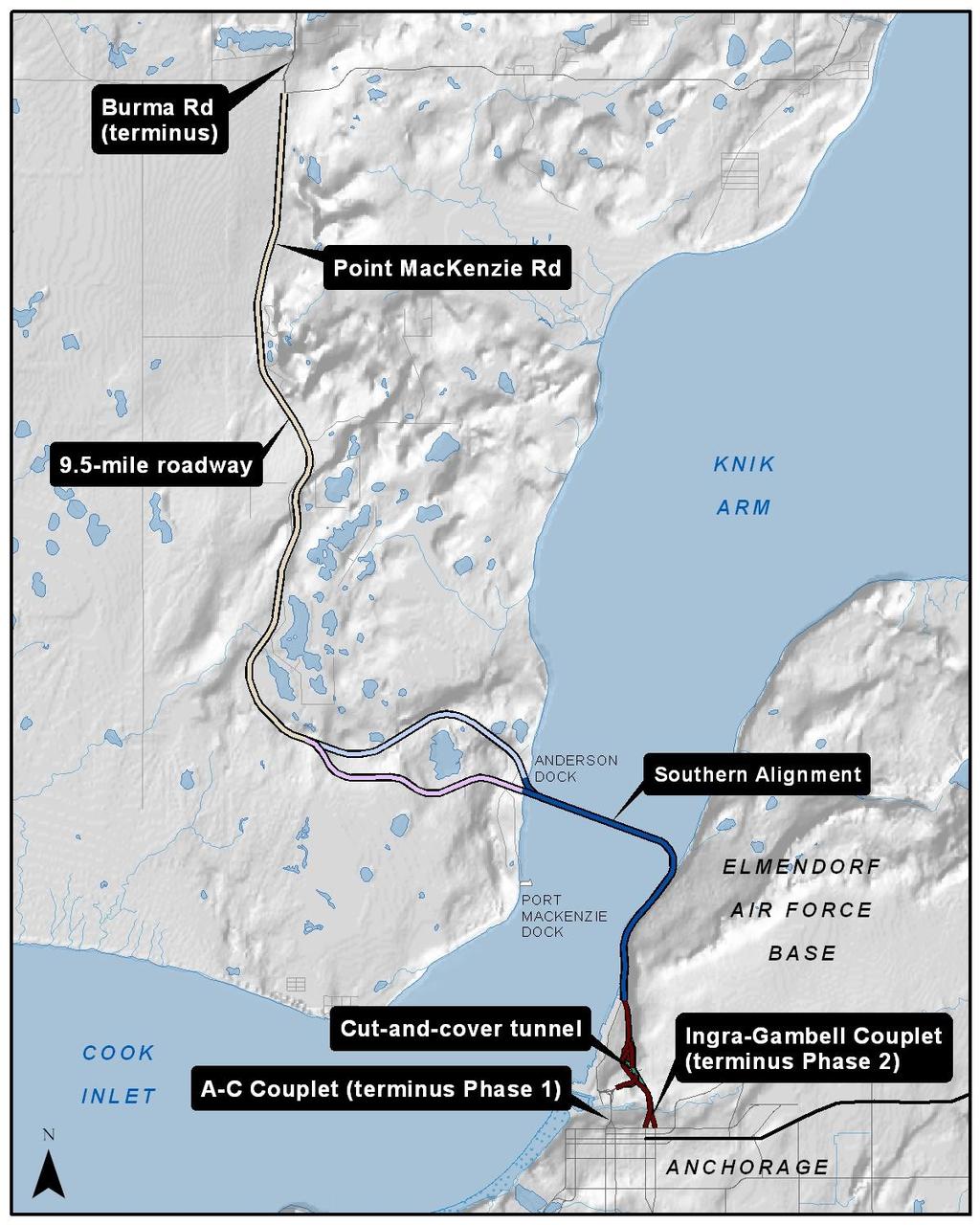


34 2035 Metropolitan Transportation Plan 7-34 FIGURE 7-5 Knik Arm Crossing Figure Knik Arm Crossing Northern Access Source: HDR Alaska, Inc. Figure The Knik Arm Crossing project.


35 FIGURE 7-6 Knik Arm Crossing Preferred Alignment 7-35 Anchorage Metropolitan Area Transportation Solutions
As detailed in the previous chapter, federal, state, and local funds will be insuf-
 Chapter 7 RECOMMENDATIONS Informed decisions about transportation issues and about where and when to allocate limited infrastructure investments rely on two key knowledge areas: (1) understanding the shape,
MUNICIPALITY OF ANCHORAGE Capital Improvement Program PRIORITY LIST BY DEPARTMENT (000's) PROJECT MANAGEMENT & ENGINEERING
 PROJECT MANAGEMENT & ENGINEERING") YEAR PROJECT TITLE CATEGORY: Roadway Improvements MUNICIPALITY OF ANCHORAGE Capital Improvement Program PRIORITY LIST BY DEPARTMENT (000's) PROJECT MANAGEMENT & ENGINEERING DEPT PRIORITY GO BONDS MATCHING
YEAR PROJECT TITLE CATEGORY: Roadway Improvements MUNICIPALITY OF ANCHORAGE Capital Improvement Program PRIORITY LIST BY DEPARTMENT (000's) PROJECT MANAGEMENT & ENGINEERING DEPT PRIORITY GO BONDS MATCHING
PROJECT MANAGEMENT & ENGINEERING
 PROJECT MANAGEMENT & ENGINEERING Goal The goal of the of Project Management and Engineering for the 2004-2009 Capital Improvement Budget/Program is to: enhance the safe and efficient movement of people
Table 1. Total Four-Year Program Summary AMATS FFY TIP Administrative Modification 2
 TRANSPORTATION IMPROVEMENTS Table 1. Total Four-Year Program Summary 2015 2016 2017 2018 Non-National Highway System (Table 3) Roadway Improvements without Pavement Replacement projects $16,900 $15,755
PROJECT MANAGEMENT & ENGINEERING
 PROJECT MANAGEMENT & ENGINEERING Goal The goal of the of Project Management and Engineering for the 2006-2011 Capital Improvement Budget/Program is to: enhance the safe and efficient movement of people
Table 1. Total Four-Year Program Summary AMATS FFY TIP FEDERAL FISCAL PROGRAMMING YEAR ($,000)
") TRANSPORTATION IMPROVEMENTS Table 1. Total Four-Year Program Summary FEDERAL FISCAL PROGRAMMING YEAR ($,000) 2015 2016 2017 2018 4-year total Non-National Highway System (Table 3) Roadway Improvements
TRANSPORTATION IMPROVEMENTS Table 1. Total Four-Year Program Summary FEDERAL FISCAL PROGRAMMING YEAR ($,000) 2015 2016 2017 2018 4-year total Non-National Highway System (Table 3) Roadway Improvements
PROJECT MANAGEMENT AND ENGINEERING
 PROJECT MANAGEMENT AND ENGINEERING PROJECT MANAGEMENT & ENGINEERING Goal The goal of the of Project Management and Engineering for the Capital Improvement Budget/Program is to improve the road and drainage
DATE: September 5, 2018 FAX: PHONE: SUBJECT:
 For 10/10/18 MEMORANDUM TO: Maren Brantner Manger STATE OF ALASKA Department of Transportation and Public Facilities Central Region DATE: September 5, 2018 FAX: 907-269-0521 PHONE: 907-269-0515 FROM: Aaron
PROJECT MANAGEMENT AND ENGINEERING
 PROJECT MANAGEMENT AND ENGINEERING PROJECT TITLE MUNICIPALITY OF ANCHORAGE Capital Improvement Program PROJECT LIST BY DEPARTMENT Project Mgmt & Engineering YEAR G.O. BONDS STATE FEDERAL OTHER TOTAL 100TH
2018 Capital Improvement Budget Project Management & Engineering Department
 2018 Capital Improvement Budget Project Management & Engineering Department (in thousands) Projects Bonds State Federal Other Total 120th Ave Upgrade - Johns Rd to Old Seward Hwy 400 - - - 400 27th Ave
PROJECT MANAGEMENT & ENGINEERING
 PROJECT MANAGEMENT & ENGINEERING Department Goal The goal of the Department of Project Management and Engineering for the - Capital Improvement Budget/Program is to improve the road and drainage facilities
2018 Capital Improvement Budget Project Management & Engineering Department
 2018 Capital Improvement Budget Project Management & Engineering Department (in thousands) Projects Bonds State Federal Other Total 120th Ave Upgrade - Johns Rd to Old Seward Hwy 400 - - - 400 27th Ave
Department Budget Discussion
 Department Budget Discussion 2010 General Government Capital & Utilities Budgets Assembly Worksession October 30, 2009 M U N I C I P A L I T Y O F A N C H O R A G E. M A Y O R D A N S U L L I V A N General
2015 Capital Improvement Budget Public Works Department
 2015 Capital Improvement Budget Public Works Department (in thousands) Projects Bonds State Federal Other Total 1% for Art Conservation - 50 - - 50 100th Ave Extension Phase II - Minnesota Dr to C St -
Tulsa Transportation Management Area. Urbanized Area Surface Transportation Program
 Tulsa Transportation Management Area Urbanized Area Surface Transportation Program FFY 2022 Application Information Sponsor Location Description STP Request Other Funds Broken Arrow Elm Place: Kenosha
Public Information Packet FY Fargo-Moorhead Metropolitan Transportation Improvement Program (TIP)
") Public Information Packet FY - Fargo-Moorhead Metropolitan Transportation Improvement Program (TIP) Comment Form Annual Element TIP Projects - TIP Projects Year - Metropolitan Transportation Improvement
Public Information Packet FY - Fargo-Moorhead Metropolitan Transportation Improvement Program (TIP) Comment Form Annual Element TIP Projects - TIP Projects Year - Metropolitan Transportation Improvement
IMPROVEMENT CONCEPTS
 IMPROVEMENT CONCEPTS for the South Novato Transit Hub Study Prepared by: January 11, 2010 DKS Associates With Wilbur Smith Associates IMPROVEMENT CONCEPTS Chapter 1: Introduction 1. INTRODUCTION The strategic
Corridor Sketch Summary
 Corridor Sketch Summary SR 241: I-82 Jct (Sunnyside) to SR 24 Jct Corridor Highway No. 241 Mileposts: 7.53 to 25.21 Length: 17.65 miles Corridor Description The seventeen and one-half mile corridor begins
July Service Change UPDATED 4/9/18
 July 2018 Service Change UPDATED 4/9/18 The Public Transportation Department regularly revises routes and service to recognize changes in travel patterns, improve on-time performance and serve you better.
Transportation Improvement Program (TIP) Candidate Project List for Public Review
 Candidate Project List for Public Review") 2011-2014 Transportation Improvement Program (TIP) Candidate List for Public Review Table 1 Annual Listing Of Federal Aid Obligation For Federal Fiscal Year 2010 North Dakota s Number Transit 410083 Transit
2011-2014 Transportation Improvement Program (TIP) Candidate List for Public Review Table 1 Annual Listing Of Federal Aid Obligation For Federal Fiscal Year 2010 North Dakota s Number Transit 410083 Transit
Unified Corridor Investment Study DRAFT Step 2 Scenario Analysis Report
 Unified Corridor Investment Study DRAFT Step 2 Scenario Analysis Report REVISIONS 1. Table 39: New Public Investments for Operation and Maintenance Costs 2. Appendix A-10: Passenger Rail Service - Operations
Location Concept Plan Amendment Recommendation Approved 2011 Concept Plan
 Valley Line West LRT Concept Plan Recommended Amendments Lewis Farms LRT Terminus Site Location Concept Plan Amendment Recommendation Approved 2011 Concept Plan Lewis Farms LRT terminus site, 87 Avenue/West
Chapter 7. Transportation Capital Improvement Projects. Chapter 7
 Chapter 7 Transportation Capital Improvement Projects Chapter 7 81 Chapter 7 Transportation Capital Improvement Projects Local Transportation Sales Tax Programs For over three decades, Santa Clara County
Develop ground transportation improvements to make the Airport a multi-modal regional
 Project Overview TRANSPORTATION IMPROVEMENTS WHAT ARE THE PROJECT GOALS? Transportation transportation hub. Develop ground transportation improvements to make the Airport a multi-modal regional Land Use
Transportation. Background. Transportation Planning Goals. Level of Service Analysis 5-1
 Transportation portion of the city s stormwater utility, and state road and fuel taxes. Background The transportation needs of the City of Lacey and its planning areas are met by a growing multimodal network
Public Works. Capital Projects FY
 Public Works Capital Projects FY 2015-17 Projects Completed FY 2014 All Done Projects! Residential and Collector Street Paving Lower Westside Arterial Street Rehab: Front, River St South, Soquel Hwy 1
APPENDIX E. Traffic Analysis Report
 APPENDIX E Traffic Analysis Report THIS PAGE INTENTIONALLY BLANK EAGLE RIVER TRAFFIC MITIGATION PHASE I OLD GLENN HIGHWAY/EAGLE RIVER ROAD INTERSECTION IMPROVEMENTS TRAFFIC ANALYSIS Eagle River, Alaska
Sepulveda Pass Corridor Systems Planning Study
 Los Angeles County Metropolitan Transportation Authority Sepulveda Pass Corridor Systems Planning Study Streets and Freeways Subcommittee January 17, 2013 1 Sepulveda Pass Study Corridor Extends for 30
MUNICIPALITY OF ANCHORAGE PLANNING AND ZONING COMMISSION RESOLUTION NO
 MUNICIPALITY OF ANCHORAGE PLANNING AND ZONING COMMISSION RESOLUTION NO. 2016-001 A RESOLUTION RECOMMENDING APPROVAL OF AN ORDINANCE AMENDING TITLE 21 (NEW CODE) TO ENABLE MARIJUANA ESTABLISHMENTS, AND
Brigham City 1200 West Box Elder Creek Bridge - Widening Project Type Reconstruction
 Brigham City 1200 West Box Elder Creek Bridge - Widening Project Type Reconstruction 550 North to 650 North $ 1,750,000 $ 1,582,113 To widen an existing bridge on 1200 West over Box Elder Creek that will
EXCEPTION TO STANDARDS REPORT
 EXCEPTION TO STANDARDS REPORT PROJECT DESCRIPTION AND NEED The project is located in Section 6, Township 23 North, Range 9 East and Section 31 Township 24 North, Range 9 East, in the Town of Stockton,
I-820 (East) Project Description. Fort Worth District. Reconstruct Southern I-820/SH 121 Interchange
 Project Description. Fort Worth District. Reconstruct Southern I-820/SH 121 Interchange") I-820 (East) Project Description Fort Worth District Reconstruct Southern I-820/SH 121 Interchange I-820 from approximately 2,000 feet north of Pipeline Road/Glenview Drive to approximately 3,200 feet
I-820 (East) Project Description Fort Worth District Reconstruct Southern I-820/SH 121 Interchange I-820 from approximately 2,000 feet north of Pipeline Road/Glenview Drive to approximately 3,200 feet
5. HORIZON YEAR TRANSPORTATION MASTER PLAN-COST ESTIMATES
 5. HORIZON YEAR TRANSPORTATION MASTER PLAN-COST ESTIMATES 5.1 INTRODUCTION This chapter of the TMP presents an opinion of probable cost estimates for the proposed Horizon Year roadway network improvements
RTID Travel Demand Modeling: Assumptions and Method of Analysis
 RTID Travel Demand Modeling: Assumptions and Method of Analysis Overall Model and Scenario Assumptions The Puget Sound Regional Council s (PSRC) regional travel demand model was used to forecast travel
King County Metro. Columbia Street Transit Priority Improvements Alternative Analysis. Downtown Southend Transit Study. May 2014.
 King County Metro Columbia Street Transit Priority Improvements Alternative Analysis Downtown Southend Transit Study May 2014 Parametrix Table of Contents Introduction... 1 Methodology... 1 Study Area...
SOUTHERN GATEWAY. Transportation and Trinity River Project Committee 11 May 2015
 SOUTHERN GATEWAY Transportation and Trinity River Project Committee 11 May 2015 Southern Gateway Project History Began in 2001 as a Major Investment Study [ MIS ], Schematic, and Environmental Assessment
FREQUENTLY ASKED QUESTIONS
 THE PROJECT Last updated on 2/19/16 FREQUENTLY ASKED QUESTIONS What s happening on Highway 169? The Minnesota Department of Transportation (MnDOT) is planning to rebuild and repair the infrastructure on
PUBLIC TRANSPORTATION
 PUBLIC TRANSPORTATION PROJECT TITLE U-MED DISTRICT MULTI-MODAL IMPROVEMENTS- PHASE II Transit Vehicles and Upgrades MUNICIPALITY OF ANCHORAGE Capital Improvement Program PROJECT LIST BY DEPARTMENT Public
US 59 (SOUTHWEST FWY) IH 610 (West Loop) to SH 288 (South Fwy)
 IH 610 (West Loop) to SH 288 (South Fwy)") Mobility Investment Priorities Project Houston US 59 US 59 (SOUTHWEST FWY) IH 610 (West Loop) to SH 288 (South Fwy) Current Conditions From IH 610 West to SH 288, US 59 operates with four or five lanes
Mobility Investment Priorities Project Houston US 59 US 59 (SOUTHWEST FWY) IH 610 (West Loop) to SH 288 (South Fwy) Current Conditions From IH 610 West to SH 288, US 59 operates with four or five lanes
Maryland Gets to Work
 I-695/Leeds Avenue Interchange Reconstruction Baltimore County Reconstruction of the I-695/Leeds Avenue interchange including replacing the I-695 Inner Loop bridges over Benson Avenue, Amtrak s Northeast
Station Evaluation. Durham-Orange Light Rail Transit Project Spring 2012
 Station Evaluation Durham-Orange Light Rail Transit Project Spring 2012 Key Ingredients for Station Development Platform Designs UNC Hospitals Station The UNC Hospitals Station Option D would be the westerly
Dixie Transportation Planning Office
 A project must be given a yes rating on items 1 & 2 in order to be prioritized. Sponsor: St. George City Project: Pioneer Parkway Type: Road Widening and Reconstruction Rev. 9/17/2010 Dixie Transportation
Metro Highway Program
 Metro Highway Program ACEC November 2018 I-5 North HOV and Truck Lanes 14 miles of HOV lanes in both directions 2 miles of truck climbing lanes at the south end 7 bridge modifications at: Gavin Canyon
Committee Report. Transportation Committee. Business Item No
 Committee Report Business Item No. 2015-280 Transportation Committee For the Metropolitan Council meeting of December 9, 2015 Subject: METRO Blue Line Extension (Bottineau Light Rail Transit) Revised Scope
FREQUENTLY ASKED QUESTIONS
 THE PROJECT Last updated on 9/8/16 FREQUENTLY ASKED QUESTIONS What s happening on Highway 169? The Minnesota Department of Transportation (MnDOT) is planning to rebuild and repair the infrastructure on
Waco Rapid Transit Corridor (RTC) Feasibility Study
 Feasibility Study") Waco Rapid Transit Corridor (RTC) Feasibility Study Chris Evilia, Director of Waco Metropolitan Planning Organization Allen Hunter, General Manager Waco Transit System Jimi Mitchell, Project Manager AECOM
Waco Rapid Transit Corridor (RTC) Feasibility Study Chris Evilia, Director of Waco Metropolitan Planning Organization Allen Hunter, General Manager Waco Transit System Jimi Mitchell, Project Manager AECOM
Rocky Mount. Transportation Plan. Transportation Planning Division. Virginia Department of Transportation
 2020 Transportation Plan Developed by the Transportation Planning Division of the Virginia Department of Transportation in cooperation with the U.S. Department of Transportation, Federal Highway Administration
TRAFFIC IMPACT STUDY. USD #497 Warehouse and Bus Site
 TRAFFIC IMPACT STUDY for USD #497 Warehouse and Bus Site Prepared by: Jason Hoskinson, PE, PTOE BG Project No. 16-12L July 8, 216 145 Wakarusa Drive Lawrence, Kansas 6649 T: 785.749.4474 F: 785.749.734
State Avenue Corridor Bus Rapid Transit (BRT)
") State Avenue Corridor Bus Rapid Transit (BRT) Moving Forward Incrementally April 2010 State Ave. BRT Update Bus Rapid Transit Overview State Ave. Alternatives Analysis Results What s Coming Up Right Away!
State Avenue Corridor Bus Rapid Transit (BRT) Moving Forward Incrementally April 2010 State Ave. BRT Update Bus Rapid Transit Overview State Ave. Alternatives Analysis Results What s Coming Up Right Away!
Mountainland Association of Governments SPRINGVILLE-SPANISH FORK AREA TRANSPORTATION STUDY APRIL 2012
 Mountainland Association of Governments SPRINGVILLE-SPANISH FORK AREA TRANSPORTATION STUDY APRIL 2012 PLANNING FOR OUR FUTURE Planners with the Mountainland Association of Governments (MAG) have evaluated
Section III Transportation and Stormwater Projects Receiving Additional Funding Project Detail Sheets Alphabetical Listing by Project Name Five Year
 Section III Transportation and Stormwater Projects Receiving Additional Funding Project Detail Sheets Alphabetical Listing by Project Name Five Year Capital Improvement Plan FY2015/2016 through FY2020
2016 PSRC REGIONAL & KING COUNTYWIDE EASTSIDE FUNDING AWARDS. Eastside Transportation Partnership September 9, 2016
 2016 PSRC REGIONAL & KING COUNTYWIDE EASTSIDE FUNDING AWARDS Eastside Transportation Partnership September 9, 2016 1 2 PSRC 2016 Project Selection Process 2018-2020 Estimated FHWA Funds Available: (Summary)
Building our future, together. Steering Committee Presentation for the Comprehensive Plan Update April 23, 2013
 Building our future, together Steering Committee Presentation for the Comprehensive Plan Update April 23, 2013 Vision In 2030, the City of Tyler will be nationally known for its commitment to community,
GTA West Corridor Planning and EA Study Stage 1
 GTA West Corridor Planning and EA Study Stage 1 Draft Development Strategy Presentation to Peel Goods Movement Task Force April 8 2011 Study Areas 2 Unique Approach Unprecedented two-stage EA process:
APPENDIX H. Transportation Impact Study
 APPENDIX H Transportation Impact Study BUENA VISTA LAGOON ENHANCEMENT PROJECT TRANSPORTATION IMPACT STUDY Prepared for: San Diego Association of Governments Prepared by: VRPA Technologies, Inc. 9520 Padgett
Reston Transportation Strategy July 9, 2018
 Reston Transportation Strategy July 9, 2018 Background: On February 11, 2014, the Board of Supervisors adopted the Reston Phase I Comprehensive Plan Amendment for the core areas of Reston between Sunset
DIXIE TIP CONCEPT REPORT APPLICATION FY 2015 (Due November 6, 2013) PROJECT INFORMATION
 PROJECT INFORMATION") DIXIE TIP CONCEPT REPORT APPLICATION FY 2015 (Due November 6, 2013) PROJECT INFORMATION 1) TITLE: Old Hwy 91 (Swiss Village, Santa Clara to 200 East, Ivins) 2) DESCRIPTION: This joint Ivins/Santa Clara
DIXIE TIP CONCEPT REPORT APPLICATION FY 2015 (Due November 6, 2013) PROJECT INFORMATION 1) TITLE: Old Hwy 91 (Swiss Village, Santa Clara to 200 East, Ivins) 2) DESCRIPTION: This joint Ivins/Santa Clara
3.1 Introduction Transportation Elements and Study Area Meeting the Need for the Project
 Chapter 3 Transportation Environment and Consequences 3. Introduction This chapter summarizes the characteristics of the transportation system in the East Link Project vicinity and discusses potential
STH 60 Northern Reliever Route Feasibility Study Report
 #233087 v3 STH 60 Northern Reliever Route Feasibility Study Report Washington County Public Works Committee Meeting September 28, 2016 1 STH 60 Northern Reliever Route Feasibility Study Hartford Area Development
CITY OF TORRANCE PUBLIC WORKS DEPARTMENT ENGINEERING DIVISION INFRASTRUCTURE UPDATE
 CITY OF TORRANCE PUBLIC WORKS DEPARTMENT ENGINEERING DIVISION INFRASTRUCTURE UPDATE TUESDAY, DECEMBER 5, 2017 1 DISCUSSION TOPICS Update of Infrastructure Action Plan (IAP) o Sidewalk and Roadway projects
Current Corridor Characteristics. MN 62 Corridor Performance
 Corridor Context The corridor runs 12 miles between I-494 and MN 55 south of Minneapolis. The corridor serves as an important East-West connection for the Metro area. A portion of the corridor has been
To: File From: Adrian Soo, P. Eng. Markham, ON File: Date: August 18, 2015
 Memo To: From: Adrian Soo, P. Eng. Markham, ON : 165620021 Date: Reference: E.C. Row Expressway, Dominion Boulevard Interchange, Dougall Avenue Interchange, and Howard 1. Review of Interchange Geometry
Open House. Highway212. Meetings. Corridor Access Management, Safety & Phasing Plan. 5:30 to 6:30 p.m. - Southwest Corridor Transportation Coalition
 Welcome Meetings 5:30 to 6:30 p.m. - Southwest Corridor Transportation Coalition 6:30 to 8:00 p.m. - Open House Why is Highway 212 Project Important? Important Arterial Route Local Support Highway 212
Proposed Project I 35 Improvements from SH 195 to I 10
 I 35 ROADWAY Proposed Project I 35 Improvements from SH 195 to I 10 The existing I 35 facility from State Highway 195 (SH 195) north of Georgetown to Interstate 10 (I 10) in San Antonio varies from four
Subarea Study. Manning Avenue (CSAH 15) Corridor Management and Safety Improvement Project. Final Version 1. Washington County.
 Corridor Management and Safety Improvement Project. Final Version 1. Washington County.") Subarea Study Manning Avenue (CSAH 15) Corridor Management and Safety Improvement Project Final Version 1 Washington County June 12, 214 SRF No. 138141 Table of Contents Introduction... 1 Forecast Methodology
Subarea Study Manning Avenue (CSAH 15) Corridor Management and Safety Improvement Project Final Version 1 Washington County June 12, 214 SRF No. 138141 Table of Contents Introduction... 1 Forecast Methodology
system performance I-820 East Loop FM 156 TxDOT is working to expand its busiest metropolitan corridors.
 system performance TxDOT is working to expand its busiest metropolitan corridors. Nine of the state s 100 most congested highways are located in Tarrant County. Six of these highways will be expanded and
I-4 Beyond the Ultimate. Florida Transportation Builders Association January 18, 2019
 I-4 Beyond the Ultimate Florida Transportation Builders Association January 18, 2019 FDOT District 5 Improving Mobility & Safety in Central Florida FDOT District 5 is: Designing and building a better Interstate
Lacey Gateway Residential Phase 1
 Lacey Gateway Residential Phase Transportation Impact Study April 23, 203 Prepared for: Gateway 850 LLC 5 Lake Bellevue Drive Suite 02 Bellevue, WA 98005 Prepared by: TENW Transportation Engineering West
Metro Transit Update. Christina Morrison, Senior Planner Metro Transit BRT/Small Starts Project Office. John Dillery, Senior Transit Planner
 Metro Transit Update Christina Morrison, Senior Planner Metro Transit BRT/Small Starts Project Office John Dillery, Senior Transit Planner Metro Transit Service Development May 16, 2013 1 Transit Planning
2040 REGIONAL TRANSPORTATION PLAN
 2040 REGIONAL TRANSPORTATION PLAN Your RTC. Our Community. 1] 2040 Regional Adopted Transportation May Plan 18, 2017 The 2040 Regional Transportation Plan (RTP) identifies the long-term transportation
Wentzville Parkway South Phase 2 & 2A
 Wentzville Parkway South Phase 2 & 2A Sponsor Wentzville Project No. RB18-000034 Project Type New Road TOTAL FUNDING Phase 2 Total County Sponsor Federal $10,000,000 $8,000,000 $2,000,000 $0 Phase 2A Total
DRAFT Design Study Report February 2015 Eagle River Traffic Mitigation Phase 1 MOA Project No Appendix D Utilities
 Appendix D Utilities This page intentionally left blank. Utilities There are numerous utilities present within the project area, including natural gas, sewer, water, electric, communications, and street
The range of alternatives has been reviewed with the RTAC Subgroup and the preliminary analysis is proceeding on the following HCT alternatives:
 Attachment 2 Boise Treasure Valley Phase 1 Alternatives Analysis August 14, 2009 Introduction The Treasure Valley High Capacity Transit Priority Corridor Phase 1 Alternatives Analysis is being prepared
Population Trends. US 12 Corridor Performance
 Corridor Context The corridor runs over 81 miles from Willmar to the Twins Cities metropolitan area. It connects the Twin Cities and the cities of Montrose, Howard Lake, Cokato, Dassel, Litchfield, Atwater,
TRANSPORTATION REVIEW
 TRANSPORTATION REVIEW - PROPOSED MIX OF LAND USES IS CONSISTENT WITH THE CITY S UNDER THE GRANVILLE BRIDGE POLICIES THAT AIM TO MEET NEIGHBOURING RESIDENTS SHOPPING NEEDS AND REDUCE RELIANCE ON AUTOMOBILE
METRO Orange Line BRT American Boulevard Station Options
 METRO Orange Line BRT American Boulevard Station Options Bloomington City Council Work Session November 18, 2013 Christina Morrison BRT/Small Starts Project Office Coordinating Planning and Design AMERICAN
Chapter 7: Corridor Visions
 Chapter 7: Corridor Visions (see also Appendix 7 for Details) January 24, 2008 NOTE: This document has been prepared using Federal funding from the United States Department of Transportation. The United
Challenges in a Post-Katrina Environment East-West Corridor Project Overview February, 2007
 EAST-WEST CORRIDOR Challenges in a Post-Katrina Environment East-West Corridor Project Overview February, 2007 Presentation Agenda Project Overview / Purpose and Need Highway Component Transit Component
Chapter 9 Recommended Locally Preferred Alternative and Alternatives for Evaluation in Draft SEIS/SEIR
 Chapter 9 Recommended Locally Preferred Alternative and Alternatives for Evaluation in Draft SEIS/SEIR 9.0 RECOMMENDED LOCALLY PREFERRED ALTERNATIVE AND ALTERNATIVES FOR EVALUATION IN DRAFT SEIS/SEIR
TRAFFIC IMPACT ANALYSIS FOR. McDONALD S RESTAURANT IN CARMICAEL Sacramento County, CA. Prepared For:
 TRAFFIC IMPACT ANALYSIS FOR McDONALD S RESTAURANT IN CARMICAEL Sacramento County, CA Prepared For: McDonald s USA, LLC Pacific Sierra Region 2999 Oak Road, Suite 900 Walnut Creek, CA 94597 Prepared By:
Major Widening/New Roadway
 Revised Evaluation s Major Widening/New Roadway This page provides a summary of any revisions made to the draft scores presented at the October th Attributable Funds Committee meeting. The information
EUGENE-SPRINGFIELD, OREGON EAST WEST PILOT BRT LANE TRANSIT DISTRICT
 EUGENE-SPRINGFIELD, OREGON EAST WEST PILOT BRT LANE TRANSIT DISTRICT (BRIEF) Table of Contents EUGENE-SPRINGFIELD, OREGON (USA)... 1 COUNTY CONTEXT AND SYSTEM DESCRIPTION... 1 SYSTEM OVERVIEW... 1 PLANNING
4.5 TRANSPORTATION AND CIRCULATION
 The transportation and circulation section of this Draft EIR describes the existing transportation system in the Planning Area and analyzes the potential impacts associated with the proposed land uses
5.9 TRANSPORTATION AND TRAFFIC
 5.9 TRANSPORTATION AND TRAFFIC This section evaluates transportation- and traffic-related impacts that have the potential to result from the construction and operation of the Project. Information and analysis
CTA Blue Line Study Area
 CTA Blue Line Study Area HISTORY OF THE CTA BLUE LINE / I-290 SYSTEM Blue Line / I-290 infrastructure is 55 years old First integrated transit / highway facility in the U.S. PROJECT STUDY AREA EXISTING
Arizona-Sonora Border Master Plan. Plan Maestro para la Frontera Arizona-Sonora
 Arizona-Sonora Border Master Plan Plan Maestro para la Frontera Arizona-Sonora Project Objectives Develop and implement a plan for identifying, prioritizing, and promoting land port of entry (LPOE), multi-modal
City of Marina. Regional Roundabout Study Utilizing Caltrans Intersection Control Evaluation Section 4: Transportation Agency for Monterey County
 Regional Roundabout Study Utilizing Caltrans Intersection Control Evaluation Section 4: City of Marina Study Intersections: RESERVATION ROAD AT BEACH ROAD RESERVATION ROAD AT DEFOREST ROAD CARDOZA AVENUE
Table of Contents INTRODUCTION... 3 PROJECT STUDY AREA Figure 1 Vicinity Map Study Area... 4 EXISTING CONDITIONS... 5 TRAFFIC OPERATIONS...
 Crosshaven Drive Corridor Study City of Vestavia Hills, Alabama Table of Contents INTRODUCTION... 3 PROJECT STUDY AREA... 3 Figure 1 Vicinity Map Study Area... 4 EXISTING CONDITIONS... 5 TRAFFIC OPERATIONS...
I-494/I-35 Interchange Vision Layout Development - BRT Station Concepts S.P B SEH No
 TECHNICAL MEMORANDUM TO: FROM: Transit Advisory Group Jeff Rhoda DATE: RE: I-494/I-35 Interchange Vision Layout Development - BRT Station Concepts S.P. 2785-330B SEH No. 123252 04.00 I-494/I-35W Interchange
CITY OF PORT TOWNSEND, WASHINGTON CAPITAL IMPROVEMENT PLAN
 Page 1 of 3 CITY OF PORT TOWNSEND, WASHINGTON CAPITAL IMPROVEMENT PLAN The six-year Capital Improvement Plan (CIP) includes capital projects for 2017 2022. This plan includes capital projects that add
Sepulveda Pass Corridor Systems Planning Study Update
 Los Angeles County Metropolitan Transportation Authority Sepulveda Pass Corridor Systems Planning Study Update June 20, 2012 Measure R Transit Corridors One of 12 Measure R Transit Corridors approved by
Draft Results and Open House
 Waco Rapid Transit Corridor (RTC) Feasibility Study Draft Results and Open House Chris Evilia, Director of Waco Metropolitan Planning Organization Allen Hunter, General Manager Waco Transit System Jimi
V03. APTA Multimodal Operations Planning Workshop August Green Line LRT
 V03 APTA Multimodal Operations Planning Workshop August 2016 Green Line LRT 2 Presentation Outline Past Present Future 3 16/03/2016 RouteAhead Update 4 4 16/03/2016 RouteAhead Update 5 5 16/03/2016 6 6
June WASHINGTON STATE DEPARTMENT OF TRANSPORTATION Alaskan Way Viaduct and Seawall Replacement Program Seattle, Washington
 DESIGN DEVIATION NOs. 1 & 2 Horizontal Stopping Sight Distance and Shoulder Width Reduction SR 99 S. Holgate St to S. King St. Viaduct Replacement Stage 2 MP 29.89 TO MP 30.78 XL-3237 PIN-809936D June
2040 Metropolitan Transportation Plan -- Table XVII-1
 C:\7. \Projects\ 2040MTP Project List_Nov16-16.xlsx ID # NAME LIMITS DESCRIPTION COST () AGENCY PROJECT TYPE* 2017 1 B Dr S and Capital Ave SW B Dr S from 3.5 Mile Rd eastward to M-66 (1.7 mi); Capital
Orange Line Bus Rapid Transit Project Plan Update. Metro Transit June 2014 D R A F T
 Orange Line Bus Rapid Transit Metro Transit D R A F T Contents 1 Background 4 2 Scope 6 2.1 Mode 2.2 Stations 2.3 Guideway 2.4 Right of Way Needs 2.5 Technology 2.6 Fare Collection 2.7 Branding and Marketing
Table Existing Traffic Conditions for Arterial Segments along Construction Access Route. Daily
 5.8 TRAFFIC, ACCESS, AND CIRCULATION This section describes existing traffic conditions in the project area; summarizes applicable regulations; and analyzes the potential traffic, access, and circulation
The Eastern Connector Study November, 2007 planning for the future
 The Eastern Connector Study November, 2007 planning for the future In late 2006, Albemarle County and the City of Charlottesville jointly initiated the Eastern Connector Corridor Study. The Project Team
ST. CROIX RIVER CROSSING PROJECT 2004 SUPPLEMENTAL ENVIRONMENTAL IMPACT STATEMENT TECHNICAL MEMORANDUM SUPPLEMENT FOR THE PREFERRED ALTERNATIVE:
 ST. CROIX RIVER CROSSING PROJECT 2004 SUPPLEMENTAL ENVIRONMENTAL IMPACT STATEMENT TECHNICAL MEMORANDUM SUPPLEMENT FOR THE PREFERRED ALTERNATIVE: TRAVEL DEMAND FORECASTS May 12, 2005 Prepared for Minnesota
Welcome. Green Line in Your Community
 Welcome Green Line in Your Community Today's session will provide you with information about Administration's recommendation for connecting the Green Line in the Beltline to Victoria Park and Inglewood/Ramsay