COMPREHENSIVE TRANSPORTATION REVIEW SHEPHERD PARK PUD WASHINGTON, DC
|
|
|
- Meryl Gardner
- 5 years ago
- Views:
Transcription

1 COMPREHENSIVE TRANSPORTATION REVIEW SHEPHERD PARK PUD WASHINGTON, DC May 31, 2016
2 Prepared by: 1140 Connecticut Avenue NW Suite 600 Washington, DC Tel: Fax: Centreville Road Suite 330 Chantilly, VA Tel: Fax: Washington Street Suite 136 Haymarket, VA Tel: Fax: This document, together with the concepts and designs presented herein, as an instrument of services, is intended for the specific purpose and client for which it was prepared. Reuse of and improper reliance on this document without written authorization by Gorove/Slade Associates, Inc., shall be without liability to Gorove/Slade Associates, Inc.
3 Contents Executive Summary... 1 Introduction... 3 Contents of Study... 3 Study Area Overview... 6 Major Transportation Features... 6 Future Regional Projects... 7 Project Design Site Access Loading Parking Bicycle and Pedestrian Facilities Transportation Demand Management (TDM) Trip Generation Traffic Operations Study Area, Scope, & Methodology Transit Existing Transit Service Proposed Transit Service Transit Site Impacts Pedestrian Facilities Pedestrian Study Area Pedestrian Infrastructure Site Impacts Bicycle Facilities Existing Bicycle Facilities Proposed Bicycle Facilities Site Impacts Crash Data Analysis Summary of Available Crash Data Potential Impacts Summary and Conclusions... 41
4 Figures Figure 1: Site Location... 5 Figure 2: Background Development Map... 9 Figure 3: Site Plan Figure 4: Study Intersections Figure 5: Residential Trip Distribution Figure 6: Proposed Supermarket Service Area Figure 7: Retail Trip Distribution Figure 8: Proposed Improvements at Georgia Avenue/Alaska Avenue/Kalmia Road Figure 9: Existing Transit Service Figure 10: Pedestrian Pathways Figure 11: Existing Pedestrian Infrastructure Figure 12: Existing Bicycle Facilities Tables Table 1: Summary of Carshare Locations... 7 Table 2: Summary of Loading Supply and Demand Table 3: Summary of Mode Split Assumptions Table 4: Trip Generation Summary Table 5: Background Development Trip Generation Table 6: Summary of Historic and Applied Growth Rates Table 7: Vehicular Capacity Analysis Results Table 8: Queuing Results Table 9: Mitigated Capacity Analysis Results Table 10: Metrobus Route Information Table 11: Sidewalk Requirements Table 12: Crash Type Breakdown Table 13: Intersection Crash Rates (2012 to 2014)... 39
5 EXECUTIVE SUMMARY The following report is a Comprehensive Transportation Review (CTR) for the Shepherd Park project located at 7828 Georgia Avenue NW. This report reviews the transportation aspects of the project s Planned Unit Development (PUD) application. The Zoning Commission Case Number is The purpose of this study is to evaluate the project s impacts to the surrounding transportation network. This evaluation is based on a technical comparison of the existing conditions, background conditions, and future conditions. This report concludes that the project will not have a detrimental impact to the surrounding transportation network assuming that all planned site design elements and mitigations are implemented. Proposed Project The development, which will redevelop the land currently occupied by two 1 story retail buildings, is located in the Shepherd Park neighborhood, in the Northwest quadrant of Washington, DC, just south of the Maryland state border. The site is generally bounded by Eastern Avenue to the north, Georgia Avenue/Alaska Avenue to the east, Kalmia Road to the south, and an existing alley to the west. The site is planned to be developed with an approximately 56,000 square foot grocery store, 199 residential units, and an additional 2,700 square feet of ground floor retail. There will also be two levels of below grade parking providing 130 spaces for the grocery store and 141 spaces for the residential units, accessed from Kalmia Road, just west of Alaska Avenue. Loading is planned to be accessed on the northwest side of the site from Eastern Avenue and will include two (2) 55 loading docks, one (1) 30 loading dock, and one (1) 20 service/delivery space. The site has been designed to ensure that all truck turning maneuvers will take place internally to minimize any impact on traffic along Eastern Avenue. Pedestrian facilities along the perimeter of the site meet DDOT standards under existing conditions. These standards will be upheld in conjunction with the project and the new sidewalks will provide an improved pedestrian environment by way of increased buffer space and pedestrian amenities such as benches. The development will supply 88 long term bicycle parking spaces within the garage that exceed zoning requirements and provide 22 temporary short term bicycle parking spaces along the perimeter of the site. Multi Modal Impacts and Recommendations Transit The site is well served by regional and local transit services such as Metrorail and Metrobus. The site is approximately 0.7 miles from the Silver Spring Metrorail station serving the Red Line. Metrobus stops are located within a block of the site along Georgia Avenue, Alaska Avenue, and Eastern Avenue. Although the development will be generating new transit trips on the network, the existing facilities have enough capacity to handle the new trips. Pedestrian The site is surrounded by a well connected pedestrian network. Most roadways within a quarter mile radius provide sidewalks, crosswalks, and curb ramps that meet DDOT standards, particularly along primary walking routes. There are some pedestrian barriers surrounding the site such as limited connectivity to the east due to Metrorail s Red Line tracks. As a result of the planned development, pedestrian facilities along the perimeter of the site will be improved to include more buffer space and pedestrian amenities such as benches. The development will ensure that sidewalks along the perimeter of the site also DDOT width requirements and provide an adequate pedestrian environment. Bicycle The site has adequate access to existing on and off street bicycle facilities. The Metropolitan Branch Trail travels along the Metrorail Red Line tracks and there is a signed bicycle route along 8 th Street. On site, the planned development will provide secure, longterm bicycle parking within the garage that exceed zoning requirements and provide short term bicycle spaces along the perimeter of the site. Vehicular The Shepherd Park site is well connected to regional roadways such as East West Highway, Georgia Avenue, Alaska Avenue, and 16 th Street as well as an existing network of collector and local roadways. Vehicular access is planned from Kalmia Road. While inbound maneuvers are expected from the east and west on Kalmia Road, outbound maneuvers are expected to be signed prohibiting right turns from the development on to Kalmia Road, thereby limiting potential impacts to the neighborhoods west of the development. However, the 1
6 capacity analysis associated with this report does assume some vehicular traffic will depart the site to the west on Kalmia Road in order to present the most conservative scenario that may occur west of the site and resolve any potential impacts that would not be mitigated by the signed prohibition of right turning vehicles exiting the site. In order to determine the potential impacts on the surrounding transportation network, this report projects future conditions with and without the development of the site and performs analyses of intersection delays. The delays associated with each analysis scenario are compared to the acceptable levels of delay set by DDOT standards to determine if the site will negatively impact the study area. Based on this criteria, the analysis concluded that three intersections required mitigation as a result of the development. Mitigation measures were proposed as follows: 16 th Street & Kalmia Road NW This report recommends this intersection be improved by shifting some green time from 16 th Street to Kalmia Road to improve level of service along Kalmia Road. Alaska Avenue/Georgia Avenue & Kalmia Road NW This report recommends changes to both Alaska Avenue & Kalmia Road and Georgia Avenue & Kalmia Road as these two intersections operate under the same signal controller. Improvements to these intersections include signal timing adjustments to include a northbound leftturn phase along Georgia Avenue, the elimination of parking along the north side of Kalmia Road between Alaska Avenue and the site driveway, and restriping along Kalmia Road. Georgia Avenue & Geranium Street NW Due to the actuated operation of this intersection, the delay along Geranium Street can only be improved if the intersection is converted from an actuated signal to a pretimed signal. This is recommended as an improvement if deemed suitable by DDOT. 2
7 INTRODUCTION This report reviews the transportation elements of the Shepherd Park PUD. The site, shown in Figure 1, is located in Northwest DC. The purpose of this report is to: 1. Review the transportation elements of the development site plan and demonstrate that the site conforms to DDOT s general polices of promoting nonautomobile modes of travel and sustainability. 2. Provide information to the District Department of Transportation (DDOT) and other agencies on how the development of the site will influence the local transportation network. This report accomplishes this by identifying the potential trips generated by the site on all major modes of travel and where these trips will be distributed on the network. 3. Determine if development of the site will lead to adverse impacts on the local transportation network. This report accomplishes this by projecting future conditions with and without development of the site and performing analyses of vehicular delays. These delays are compared to the acceptable levels of delay set by DDOT standards to determine if the site will negatively impact the study area. The report discusses what improvements to the transportation network are needed to mitigate adverse impacts. PROPOSED PROJECT The development, which will redevelop the land currently occupied by two 1 story retail buildings, is located in the Shepherd Park neighborhood, in the Northwest quadrant of Washington, DC, just south of the Maryland state border. The site is generally bounded by Eastern Avenue to the north, Georgia Avenue/Alaska Avenue to the east, Kalmia Road to the south, and an existing alley to the west. The site is planned to be developed with an approximately 56,000 square foot grocery store, 199 residential units, and an additional 2,700 square feet of ground floor retail. There will also be two levels of below grade parking providing 130 spaces for the grocery store and 141 spaces for the residential units, access from Kalmia Road, just west of Alaska Avenue. Loading is planned to be accessed on the northwest side of the site from Eastern Avenue and will include two (2) 55 loading docks, one (1) 30 loading dock, and one (1) 20 service/delivery space. The site has been designed to ensure that all truck turning maneuvers will take place internally in order to minimize any impact on traffic along Eastern Avenue. CONTENTS OF STUDY This report contains nine sections as follows: Study Area Overview This section reviews transportation related elements of the area near and adjacent to the proposed project and includes an overview of the site location. Project Design This section reviews the transportation components of the project, including the site plan and access. This chapter also contains the proposed Transportation Demand Management (TDM) plan for the site. Trip Generation This section outlines the travel demand of the proposed project. It summarizes the anticipated multi modal trip generation of the project. Traffic Operations This section provides a summary of the existing roadway facilities and an analysis of the existing and future roadway capacity in the study area. This section highlights the vehicular impacts of the project, including presenting proposed mitigation measures. Transit This section summarizes the existing and future transit service adjacent to the site, reviews how the project s transit demand will be accommodated, outlines impacts, and presents recommendations as needed. Pedestrian Facilities This section summarizes existing and future pedestrian access to the site, reviews walking routes to and from the project site, outlines impacts, and presents recommendations as needed. Bicycle Facilities This section summarizes existing and future bicycle access to the site, reviews the quality of cycling routes to and from the project site, outlines impacts, and presents recommendations as needed. 3
8 Safety/Crash Analysis This section reviews the potential safety impacts of the project. This includes a review of crash data at intersections in the study area and a qualitative discussion on how the development will influence safety. Summary and Conclusions This section presents a summary of the recommended mitigation measures by mode and presents overall report findings and conclusions. 4


9 Figure 1: Site Location 5
10 STUDY AREA OVERVIEW This section reviews the existing conditions of the surrounding transportation network and includes an overview of the site location, including a summary of the major transportation characteristics of the area and of future regional projects. More specific characteristics of each mode and their subsequent study areas will be defined in later sections of this report. The following conclusions are reached within this chapter: The site is surrounded by an extensive regional and local transportation system that will accommodate the residents, employees, and patrons of the proposed development. The site is well served by public transportation with access to the Metrorail s Red line and multiple primary Metrobus lines. There are existing bicycle facilities surrounding the site including the Metropolitan Branch Trail. The site is surrounded by a well connected pedestrian environment, with the majority of sidewalks and crossings meeting DDOT requirements. MAJOR TRANSPORTATION FEATURES Overview of Regional Access Under existing conditions the Shepherd Park site has access to regional vehicular and transit based transportation options that connect the site to destinations within the District, Virginia, and Maryland. The site is accessible from several interstates and arterials such as East West Highway, Georgia Avenue, Alaska Avenue, and 16 th Street. These roadways provide a convenient connection to the Capital Beltway (I 495) that surrounds Washington, DC and its inner suburbs as well as regional access to I 95. These roadways either provide direct access to the site or bring vehicular traffic to a point at which minor arterials, collectors, and local roads can be used to access the site directly. The site has access to the Red Line via the Silver Spring Metrorail station, which provides connections to areas in the District and Maryland. The Red Line connects Rockville, MD with Glenmont, MD while providing access to the District core. Of particular importance, the Red Line provides a direct connection to Union Station, which is a hub for commuter rail such as Amtrak, MARC, and VRE in addition to all other Metrorail lines, allowing for access to much of the DC Metropolitan area. The Silver Spring Metrorail station also acts as a hub for commuter service via the MARC Brunswick Line that travels between Union Station and Martinsburg, West Virginia with an additional connection to Frederick, Maryland. Overall, the site has access to several regional roadways and transit options, making it convenient to travel between the site and destinations in the District, Virginia, and Maryland. Overview of Local Access There are several local transportation options near the site that serve vehicular, transit, walking, and cycling trips under existing conditions. The site is served by a local vehicular network that includes multiple collectors such as Eastern Avenue and Kalmia Road. In addition, there is an existing network of local roadways that provide access to the site. The Metrobus system provides local transit service in the vicinity of the site, including connections to several neighborhoods within the District and additional Metrorail stations. There are four bus routes that service the site. In the vicinity of the site the majority of routes travel along Alaska Avenue, Georgia Avenue, and Eastern Avenue. There are existing bicycle facilities that connect the site to areas within the District, most notably the Metropolitan Branch Trail which travels along the Red Line Metrorail tracks and provides a connection to Union Station. Other facilities include a signed bicycle route along 8 th Street. A detailed review of existing and proposed bicycle facilities and connectivity is provided in a later section of this report. In the vicinity of the site, most sidewalks meet DDOT requirements. Anticipated pedestrian routes, such as those to public transportation stops, retail zones, and community amenities, provide well connected pedestrian facilities. There are some pedestrian barriers in the area that limit the overall connectivity to and from the site and some sidewalks that do not meet DDOT standards. A detailed review of existing and proposed pedestrian access and infrastructure is provided in a later section of this report. 6
11 Overall, the site is surrounded by an extensive local transportation network that allows for efficient transportation options via transit, bicycle, walking, or vehicular modes. Car sharing Three car sharing companies provide service in the District: Zipcar, Enterprise Carshare, and Car2Go. All three services are private companies that provide registered users access to a variety of automobiles. Of these, Zipcar and Enterprise Carshare have designated spaces for their vehicles. There are no Enterprise Carshare locations located within a half mile of the site; however, there are three Zipcar locations within a half mile. These locations and the number of available vehicles are listed in Table 1. Car sharing is also provided by Car2Go, which provides pointto point car sharing. Unlike Zipcar or Enterprise Carshare, which require two way trips, Car2Go can be used for one way rentals. Car2Go currently has a fleet of vehicles located throughout the District. Car2Go vehicles may park in any nonrestricted metered curbside parking space or Residential Parking Permit (RPP) location in any zone throughout the defined Home Area. Members do not have to pay meters or pay stations. Car2Go does not have permanent designated spaces for their vehicles; however availability is tracked through their website, which provides an additional option for car sharing patrons. Table 1: Summary of Carshare Locations Carshare Location Number of Vehicles Kennett Street Parking Lot 1 vehicle The Veridian of Silver Spring 1 vehicle 1200 East West Hwy Silver Spring 2 vehicles Total 4 vehicles FUTURE REGIONAL PROJECTS There are several District initiatives and background developments located in the vicinity of the site. These planned and proposed projects are summarized below. Local Initiatives Upper Georgia Avenue Great Street Redevelopment Program The Upper Georgia Avenue Great Streets Redevelopment Plan presents a vision for the future of Georgia Avenue from Decatur Street to Eastern Avenue and outlines the framework for future development and revitalization of Georgia Avenue. For the purpose of the study, the corridor was broken down into five different zones in order to development a plan consistent with the needs of each zone. The Shepherd Park development is located in Zone 1 which extends from Eastern Avenue to Fern Street and is called the Gateway, as it acts as the entrance to the District of Columbia from Maryland. The plan provides guidelines for Zone 1 as outlined below and are consistent with the overall development plan and design strategies for the Shepherd Park development: New development should anchor the Georgia and Eastern Avenue intersection and create a prominent gateway into the district. Proposed new development should include a mix of uses and users to ensure an active destination for residents, retailers, customers, and businesses. Specifically, new development at the 7800 and 7700 blocks of Georgia Avenue should consist of moderate to medium density, incorporating street level retail with residential or office uses above. Participants cited insufficient parking in the area for commercial uses; a coordinated parking demand management strategy is necessary to accommodate new and existing development. Parking for any new development should be located at the rear of the site, preferably underground or wrapped with other uses; developments that propose shared parking solutions with other businesses or developments are especially encouraged. Through the provision of improved and safer pedestrian connections, increased opportunities for bicycle amenities as well as minimizing existing barriers, the overall accessibility of the corridor can greatly be enhanced. MoveDC: Multimodal Long Range Transportation Plan MoveDC is an implementation based plan that provides a vision for the future of DC s transportation system. As the District grows, so must the transportation system, specifically in a way that expands transportation choices while improving the reliability of all transportation modes. The MoveDC report outlines recommendations by mode with the goal of having them complete by The plan hopes to achieve a transportation system for the District that includes: 70 miles of high capacity transit (streetcar or bus) 7
12 200 miles of on street bicycle facilities or trails Sidewalks on at least one side of every street New street connections Road management/pricing in key corridors and the Central Employment Area A new downtown Metrorail loop Expanded commuter rail Water taxis In direct relation to the proposed development, the MoveDC plan outlines recommended transit and bicycle improvements such as a Streetcar route and new bicycle facilities. These recommendations would create additional multi modal capacity and connectivity to the proposed development. Planned Developments There are several potential development projects in the vicinity of the Shepherd Park site. For the purpose of this analysis, only approved developments expected to be complete prior to the planned development with an origin/destination within the study area were included. A detailed list of all background developments considered and a description of their applicability for incorporation in the study is included in the Technical Attachments. Figure 2 also depicts the location of these developments in relation to the study area. Of the background developments considered, one was ultimately included, as described below Newell Street The site is an existing self storage center that will be redeveloped to include 200 residential units and 5,000 square feet of retail space. The development is approved and expected to be complete prior to the Shepherd Park development. 8

13 Figure 2: Background Development Map 9
14 PROJECT DESIGN This section reviews the transportation components of the Shepherd Park development, including the proposed site plan and access points. It includes descriptions of the site s vehicular access, loading, parking, and Transportation Demand Management (TDM) plan. It supplements the information provided in the site plans package that accompanied the Zoning Application, which includes several illustrations of site circulation and layout. The project will redevelop the existing one story buildings and associated surface parking lots with a mixed use project including residential and retail elements. The development will include 199 residential units, an approximately 56,000 square foot grocery store, and approximately 2,700 square feet of ground floor retail space. The development will also include 271 parking spaces located in a below grade parking garage. A ground floor site plan is shown in Figure 3. SITE ACCESS Primary pedestrian access for the residential portion of the site will be along Kalmia Road, a residential collector road. Pedestrian access for the retail components of the site will be along Eastern Avenue, which observes more foot traffic. Parking access for the development will be off of one curb cut along Kalmia Road. While inbound maneuvers are expected from the east and west on Kalmia Road, outbound maneuvers are expected to be signed prohibiting right turns from the development on to Kalmia Road, thereby limiting potential impacts to the neighborhoods west of the development. Loading access will be off of one curb cut along Eastern Avenue. The loading area will accommodate head in/head out loading operations with all truck maneuvering accommodated within the site. Both curb cuts were approved by the Public Space Committee on December 17, The locations of the primary pedestrian and vehicular access points are shown on Figure 3. LOADING The development will supply one (1) 55 loading berth and one (1) 30 loading berth for the grocery store/retail component and one (1) 55 loading berth for the residential component. In addition there will be one (1) 20 service/delivery space to be shared between the residential and retail uses in lieu of one exclusive space per land use, as required by zoning. Truck routing to and from the site will be focused on designated primary truck routes, such as Georgia Avenue. The location of the loading access along Eastern Avenue will result in convenient access to this truck route. Turning maneuvers into and out of the site for each loading berth are included in the Technical Attachments. The amount of loading expected at the site is estimated as follows: As a baseline, it is assumed that there will be three daily truck deliveries for the site as a whole (covering trash, a general shared delivery, and mail). Residential loading activity is estimated assuming an expected rental turnover of 18 months, with two trucks per move one move in and one move out. A typical grocery store is expected to have six deliveries per day. Using these estimates, the anticipated loading activity for each loading area is shown in Table 2. According to DC zoning requirements, the residential component of the development is required to provide one (1) 55 loading berth and one (1) 20 delivery space. The grocery store component of the development is required to provide one (1) 55 loading berth, one (1) 30 loading berth, and one (1) 20 service/delivery space. The development is proposing to include all of these elements with the exception of a 20 service/delivery space for the residential component, in which it is proposed that the residential and grocery store components share one (1) 20 service/delivery space. Based on the anticipated loading demand, the proposed amount of Loading Area Proposed Loading Facilities Anticipated Daily Loading Demand One (1) 55' loading berth Three (3) shared deliveries** Grocery Store Component One (1) 30' loading berth Six (6) WB 50/SU 30 deliveries One (1) 20' service/delivery space* Residential Component One (1) 55' loading berth One (1) WB 50/SU 30 delivery * To be shared with the residential component Table ** loading 2: Summary activity of attributed Loading Supply to the site and as Demand a whole 10
15 loading is sufficient to accommodate all loading and service requirements on site. PARKING Based on current District zoning laws, and cited on page A 01 of the Zoning application, the development is required to supply 71 parking spaces for the grocery store component and 67 spaces for the residential component, per zoning requirements. The site will meet these requirements by supplying 130 spaces for the grocery store component and 141 spaces for the residential component. Parking will be allocated to the residential component of the site at a ratio of 0.7 parking spaces per unit. Although this is higher than other more dense areas of the District, given the proximity of the site to Metrorail and the distribution of unit sizes, this parking ratio is acceptable. BICYCLE AND PEDESTRIAN FACILITIES The project will include both short and long term bicycle parking spaces. 88 long term bicycle parking spaces will be supplied in the garage: 82 of these will be allocated for residential use and 6 will be allocated for grocery store use. In addition, 22 short term bicycle parking spaces will be placed along the perimeter of the site. These short term spaces will include inverted U racks placed in high visibility areas. Pedestrian facilities will be improved along the perimeter of the site. Improved landscaped buffers will be constructed along Eastern Avenue and Georgia Avenue and pedestrian amenities such as benches will be added. Sidewalks will be constructed to meet or exceed DDOT standards surrounding the site. The Applicant will identify a TDM Leader. The TDM Leader will work with residents to distribute and market various transportation alternatives and options. The Applicant will establish a TDM marketing program that provides detailed transportation information and promotes walking, cycling, and transit. An effective marketing strategy should consist of a multi modal access guide that provides comprehensive transportation information. This information can be compiled in a brochure for distribution. The marketing program should also utilize and provide website links to CommuterConnections.com and godcgo.com, which provide transportation information and options for getting around the District. The Applicant will unbundle all parking costs from the cost of the lease and set the cost at no less than the charges of the lowest fee garage located within a quarter mile of the site. The Applicant will work with DDOT to dedicate two (2) parking spaces within Public Space adjacent to the development for car sharing services to use with right of first refusal. The Applicant will install Transportation Information Center Displays (kiosks or screens) within the lobbies of the residential building, containing information related to local transportation alternatives. The Applicant will supply long term secure bicycle parking within the garages and short term bicycle parking along the interior and perimeter of the site that exceed zoning requirements. TRANSPORTATION DEMAND MANAGEMENT (TDM) TDM is the application of policies and strategies used to reduce travel demand or to redistribute demand to other times or spaces. TDM typically focuses on reducing the demand of single occupancy, private vehicles during peak period travel times or on shifting single occupancy vehicular demand to offpeak periods. The Transportation Demand Management (TDM) plan for the planned development is based on the DDOT expectations for TDM programs. The Applicant proposes the following TDM measures: 11
16 Figure 3: Site Plan 12
17 TRIP GENERATION This section outlines the transportation demand of the proposed Shepherd Park development. It summarizes the projected trip generation of the site by land use and by mode, which forms the basis for the chapters that follow. This development incorporates multiple land uses including residential, retail, and grocery store components. Traditionally, weekday peak hour trip generation is calculated based on the methodology outlined in the Institute of Transportation Engineers (ITE) Trip Generation Manual, 9 th Edition. This methodology was supplemented to account for the urban nature of the site (the Trip Generation Manual provides data for non urban, low transit uses) to generate trips for multiple modes. Residential trip generation was calculated based on ITE land use 220, Apartments, splitting trips into different modes using assumptions based on census data for the residents that currently live near the site. The vehicular mode split was then adjusted from the census data to reflect the parking supply and other developments with similar proximity to Metrorail. Retail trip generation was calculated based on ITE lane use 820, Shopping Center. Due to the small scale of the retail space the ITE rate for Shopping Center was used in lieu of the equation. The grocery store trip generation was calculated based on ITE land use 850, Supermarket. Mode split for both the retail and grocery store components were primarily based on data for retail sites from the WMATA Ridership Survey, influenced by census data for employees that travel to the site to take into account employees that will be arriving or departing during the peak hours. The mode split assumptions for all land uses within the development is summarized in Table 3. A summary of the multimodal trip generation for the development is shown on Table 4. Table 3: Summary of Mode Split Assumptions Land Use Mode Auto Transit Bike Walk Residential 55% 33% 2% 10% Grocery Store/Retail 60% 20% 5% 15% Table 4: Trip Generation Summary Trip Gen Summary by Land Use/Mode Mode Land Use AM Peak Hour PM Peak Hour Saturday Peak Hour In Out Total In Out Total In Out Total Auto Apartments 12 veh/hr 44 veh/hr 56 veh/hr 46 veh/hr 24 veh/hr 70 veh/hr 28 veh/hr 29 veh/hr 57 veh/hr Auto Supermarket 71 veh/hr 44 veh/hr 115 veh/hr 130 veh/hr 125 veh/hr 255 veh/hr 146 veh/hr 140 veh/hr 286 veh/hr Auto Retail 1 veh/hr 1 veh/hr 2 veh/hr 3 veh/hr 3 veh/hr 6 veh/hr 4 veh/hr 4 veh/hr 8 veh/hr Auto Total 84 veh/hr 89 veh/hr 173 veh/hr 179 veh/hr 152 veh/hr 331 veh/hr 178 veh/hr 173 veh/hr 351 veh/hr Transit Apartments 8 ppl/hr 30 ppl/hr 38 ppl/hr 31 ppl/hr 17 ppl/hr 48 ppl/hr 19 ppl/hr 20 ppl/hr 39 ppl/hr Transit Supermarket 43 ppl/hr 27 ppl/hr 70 ppl/hr 100 ppl/hr 96 ppl/hr 196 ppl/hr 112 ppl/hr 108 ppl/hr 220 ppl/hr Transit Retail 1 ppl/hr 0 ppl/hr 1 ppl/hr 2 ppl/hr 2 ppl/hr 4 ppl/hr 2 ppl/hr 3 ppl/hr 5 ppl/hr Transit Total 52 ppl/hr 57 ppl/hr 109 ppl/hr 133 ppl/hr 115 ppl/hr 248 ppl/hr 133 ppl/hr 131 ppl/hr 264 ppl/hr Bike Apartments 0 ppl/hr 2 ppl/hr 2 ppl/hr 2 ppl/hr 1 ppl/hr 3 ppl/hr 1 ppl/hr 1 ppl/hr 2 ppl/hr Bike Supermarket 11 ppl/hr 7 ppl/hr 18 ppl/hr 25 ppl/hr 24 ppl/hr 49 ppl/hr 28 ppl/hr 27 ppl/hr 55 ppl/hr Bike Retail 0 ppl/hr 0 ppl/hr 0 ppl/hr 0 ppl/hr 1 ppl/hr 1 ppl/hr 1 ppl/hr 0 ppl/hr 1 ppl/hr Bike Total 11 ppl/hr 9 ppl/hr 20 ppl/hr 27 ppl/hr 26 ppl/hr 53 ppl/hr 30 ppl/hr 28 ppl/hr 58 ppl/hr Walk Apartments 2 ppl/hr 9 ppl/hr 11 ppl/hr 9 ppl/hr 5 ppl/hr 14 ppl/hr 6 ppl/hr 6 ppl/hr 12 ppl/hr Walk Supermarket 33 ppl/hr 20 ppl/hr 53 ppl/hr 75 ppl/hr 72 ppl/hr 147 ppl/hr 84 ppl/hr 81 ppl/hr 165 ppl/hr Walk Retail 1 ppl/hr 0 ppl/hr 1 ppl/hr 1 ppl/hr 2 ppl/hr 3 ppl/hr 2 ppl/hr 1 ppl/hr 3 ppl/hr Walk Total 36 ppl/hr 29 ppl/hr 65 ppl/hr 85 ppl/hr 79 ppl/hr 164 ppl/hr 92 ppl/hr 88 ppl/hr 180 ppl/hr 13
18 TRAFFIC OPERATIONS This section provides a summary of an analysis of the existing and future roadway capacity in the study area. Included is an analysis of potential vehicular impacts of the Shepherd Park development and a discussion of potential improvements. The purpose of the capacity analysis is to: Determine the existing capacity of the study area roadways; Determine the overall impact of the project on the study area roadways; and Discuss potential improvements and mitigation measures to accommodate the additional vehicular trips This analysis was accomplished by determining the traffic volumes and roadway capacity for the following scenarios: Existing Conditions Future Conditions without the development (2018 Background) Future Conditions with the development (2018 Future) The capacity analysis focuses on the morning and afternoon commuter peak hours as well as the Saturday midday peak hour, as determined by the existing traffic volumes in the study area. The following conclusions are reached within this chapter: There are multiple study intersections that operate at unacceptable levels of service during at least one study scenario; three of these intersections operate at unacceptable conditions as a direct result of the development. Mitigation measures were analyzed and discussed for each of the three intersections. These mitigations greatly improve the overall operations at these intersections. Mitigation measures at the intersection of Alaska Avenue and Kalmia Road are most extensive and impact the directly adjacent intersection of Georgia Avenue and Kalmia Road, since they operate under the same signal controller. Improvements at these intersections include signal timing, striping, and intersection geometry adjustments. Overall, this report concludes that the project will not have a detrimental impact to the surrounding transportation network, assuming all mitigations are implemented. STUDY AREA, SCOPE, & METHODOLOGY This section outlines the vehicular trips generated in the study area along the vehicular access routes and defines the analysis assumptions. The scope of the analysis contained within this report was discussed with and agreed to with DDOT. The general methodology of the analysis follows national and DDOT guidelines on the preparation of transportation impact evaluations of site development, unless stated otherwise. Capacity Analysis Scenarios The vehicular analyses are performed to determine if the proposed development of the Shepherd Park development will lead to adverse impacts on traffic operations. (A review of impacts to each of the other modes is outlined later in this report.) This is accomplished by comparing future scenarios: (1) without the proposed development (referred to as the Background conditions) and (2) with the development approved and constructed (referred to as the Future conditions). Specifically, the roadway capacity analysis examined the following scenarios: Existing Conditions Future Conditions without the development (2018 Background) Future Conditions with the development (2018 Future) Study Area The study area of the analysis is a set of intersections where detailed capacity analyses are performed for the scenarios listed above. The set of intersections decided upon during the study scoping process with DDOT are those intersections most likely to have potential impacts or require changes to traffic operations to accommodate the proposed development. Although it is possible that impacts will occur outside of the study area, those impacts are not significant enough to be considered a detrimental impact nor worthy of mitigation measures. 14
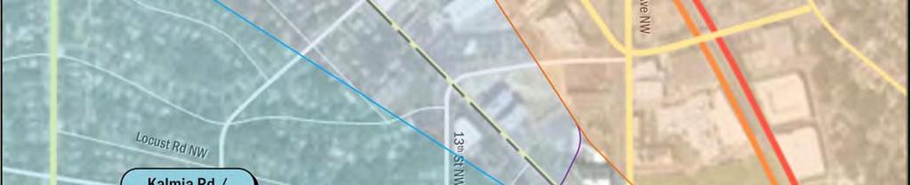
19 Based on the projected future trip generation and the location of the site access points, the following intersections were chosen for analysis in consultation with DDOT: 1. Eastern Avenue & 14 th Street NW 2. Eastern Avenue & 13 th Street NW 3. Eastern Avenue & 12 th Street NW 4. Eastern Avenue & Alley NW 5. Georgia Avenue & Eastern Avenue/Blair Road NW 6. Eastern Avenue & Blair Road NW th Street & Kalmia Road NW 8. Kalmia Road & 13 th Street NW 9. Kalmia Road & 12 th Street NW 10. Kalmia Road & Existing/Future Driveway 11. Kalmia Road & Alaska Avenue NW 12. Georgia Avenue & Kalmia Road NW 13. Georgia Avenue & Geranium Street NW 14. Geranium Street & 13 th Street NW 15. Alaska Avenue & 13 th Street & Hemlock Street NW Figure 4 shows a map of the study area intersections. Traffic Volume Assumptions The following section reviews the traffic volume assumptions and methodologies used in the roadway capacity analyses. Existing Traffic Volumes The existing traffic volumes are comprised of turning movement count data, which was collected on Wednesday, October 7, 2015, Saturday, October 10, 2015, Tuesday, October 13, 2015, Thursday, October 15, 2015, and Saturday, October 17, The results of the traffic counts and the existing peak hour traffic volumes are included in the Technical Attachments. For all intersections the individual morning, afternoon, and Saturday peak hours were used Background Traffic Volumes (without the project) Traffic projections for the background conditions typically consist of the existing volumes with two additions: Traffic generated by developments expected to be completed prior to the project (known as background developments); and Inherent growth on the roadway (representing regional traffic growth). Following industry, national, and DDOT methodologies, a background development must meet the following criteria to be incorporated into the analysis: Be located in the study area, defined as having an origin or destination point within the cluster of study area intersections; Have entitlements; and Have a construction completion date prior or close to the proposed development. As discussed previously, multiple background developments were considered for inclusion in the study, with one development ultimately meeting all of the criteria. This development is as follows: 8001 Newell Street Trip generation was calculated based on the Institute of Transportation Engineers Trip Generation Manual, 9 th Edition, with a non auto reduction based on those used for similar developments and the proximity to Metrorail. Trip distribution assumptions for the background development were based on those determined for the Shepherd Park development. Trip generation assumptions for the background development are shown in Table 5. Table 5: Background Development Trip Generation Background Development Quantity AM Peak Hour PM Peak Hour Saturday Peak Hour In Out Total In Out Total In Out Total 8001 Newell Street Retail 5000 SF Non Auto Reduction 30% High Rise Apartments 200 DU Non Auto Reduction 65% Existing Self Storage SF Net New Trips
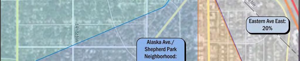
20 While the background developments represent local traffic changes, regional traffic growth is typically accounted for using percentage growth rates. Growth rates for the study area were derived based on a comparison between existing and past average annual weekday traffic volumes obtained from DDOT for 2010 to Although trends showed that all study area roadways have had negligible or negative growth over the fouryear period, an annual growth rate of 0.25 percent was applied to the through movements of the roadways in order to maintain a conservative analysis. The applied growth rates are shown in Table 6. The traffic volumes generated by the background development and the inherent growth along the network were added to the existing traffic volumes in order to establish the 2018 Background traffic volumes. The traffic volumes for the 2018 Background conditions are included in the Technical Attachments Total Future Traffic Volumes (with the project) The 2018 Total Future traffic volumes consist of the 2018 Background volumes with the addition of the traffic volumes generated by the proposed development (site generated trips) as well as the subtraction of existing traffic at the driveway. The existing traffic was determined based on existing counts at the driveway and was distributed through the network based on existing traffic volumes and travel patterns. Thus, the 2018 Total Future traffic volumes include: the existing volumes, background development traffic, the inherent growth on the study area roadways, the removal of existing trips, and trips generated by the proposed project. Site generated trips were distributed across the network based on two different trip distributions: one for residential trips and one for retail trips to account for the multiple land uses associated with the development. Both site trip distributions were scoped in consultation with and approved by DDOT. The residential trip distribution was determined based on existing traffic volumes and travel patterns and is shown in Figure 5. Because the retail portion of the development consists primarily of a grocery store, a market study was performed. All full service supermarkets within the area were located and used to determine the most likely service area of the proposed Shepherd Park grocery store, as shown in Figure 6. U.S. Census data (analyzed by block group) was used to determine the population of the area and the most likely routes were defined. The percentage of people using each route was based on the percentage of the population coming from that direction. The retail trip distribution is shown in Figure 7. It should be noted that the surrounding community has expressed interest in limiting traffic approaching the site to and from the west along Kalmia Road. Given that DDOT has expressed reservations with the implementation of curbdesigned strategies to prohibit site trips to and from the west on Kalmia Road, it is expected that southbound right turns from the driveway exiting the site onto Kalmia Road will be restricted via signage. With the orientation of the site toward Georgia Avenue, this restriction is expected to most apply to residents immediately west of the development in the Shepherd Park neighborhood between Georgia Avenue and 16 th Street. Should this restriction be implemented, it is expected that residents of the neighborhood west of the site would be required to exit the site to Alaska Avenue or Georgia Avenue (to Eastern Avenue) to return to the west. However, in order to present a conservative scenario in the capacity analysis for the intersections west of the site along Kalmia Road, this restriction has not been accounted for in the site trip assignments. Table 6: Summary of Historic and Applied Growth Rates Street AADT Volumes Historic Annual Growth Rate Applied Annual Growth Rate 16 th Street % 0.25% Georgia Avenue % 0.25% Eastern Avenue % 0.25% Kalmia Road % 0.25% Alaska Avenue % 0.25% 13 th Street % 0.25% 16
21 Based on the trip distribution percentages and the proposed site access location, the site generated trips were distributed through the study area intersections for the weekday morning, weekday afternoon, and Saturday midday peak hours. The traffic volumes for the 2018 future conditions were calculated by adding the site generated volumes to the 2018 background traffic volumes. The 2016 future traffic volumes are included in the Technical Attachments. Geometry and Operations Assumptions The following section reviews the roadway geometry and operations assumptions made and the methodologies used in the roadway capacity analyses. Existing Geometry and Operations Assumptions The geometry and operations assumed in the existing conditions scenario are those present when the main data collection occurred. Gorove/Slade made observations and confirmed the existing lane configurations and traffic controls at the intersections within the study area. The lane configurations and traffic controls for the Existing conditions are shown in the Technical Attachments. Background Geometry and Operations Assumptions Following national and DDOT methodologies, a background improvement must meet the following criteria to be incorporated into the analysis: Be funded; and Have a construction completion date prior or close to the proposed development. Based on these criteria, no background assumptions were included in the analysis. Therefore, the lane configurations and traffic controls for the 2018 background conditions are based on the existing conditions. Total Future Geometry and Operations Assumptions The lane configurations for the 2018 future conditions with the proposed development are based on the lane configurations for the 2018 conditions without the proposed development. No roadway infrastructure changes were assumed for the future conditions with development for 2016; therefore, the lane configurations and traffic controls for the 2018 future conditions are based on the existing conditions. Vehicular Analysis Results Intersection Capacity Analysis Intersection capacity analyses were performed for the three scenarios outlined previously at the intersections contained within the study area during the morning, afternoon, and Saturday peak hours. Synchro, version 8.0 was used to analyze the study intersections based on the Highway Capacity Manual 2000 (HCM) methodology. The results of the capacity analyses are expressed in level of service (LOS) and delay (seconds per vehicle) for each approach. A LOS grade is a letter grade based on the average delay (in seconds) experienced by motorists traveling through an intersection. LOS results range from A being the best to F being the worst. LOS D is typically used as the acceptable LOS threshold in the District; although LOS E or F is sometimes accepted in urbanized areas if vehicular improvements would be a detriment to safety or non auto modes of transportation. The LOS capacity analyses were based on: (1) the peak hour traffic volumes; (2) the lane use and traffic controls; and (3) the Highway Capacity Manual (HCM) methodologies (using the Synchro software). The average delay of each approach and LOS is shown for the signalized intersections in addition to the overall average delay and intersection LOS grade. The HCM does not give guidelines for calculating the average delay for a two way stop controlled intersection, as the approaches without stop signs would technically have no delay. Detailed LOS descriptions and the analysis worksheets are contained in the Technical Attachments. Table 7 shows the results of the capacity analyses, including LOS and average delay per vehicle (in seconds) during the morning, afternoon, and Saturday peak hours for the Existing, 2018 Background, and 2018 Future scenarios. The capacity analysis worksheets for all scenarios are included in the Technical Attachments. The majority of the study intersections operate at acceptable conditions during the weekday morning, weekday afternoon, and Saturday peak hours for the Existing, 2018 Background, and 2018 Future scenarios with the exception of the following: The eastbound approach of Kalmia Road at 16 th Street operates at LOS E during the PM peak hour under Future Conditions. 17
22 The eastbound approach of Kalmia Road at Alaska Avenue operates at LOS F during the PM peak hour under Future Conditions. The westbound approach of Geranium Street at Georgia Avenue operates at LOS F during the AM peak hour under Existing, Background, and Future Conditions. The eastbound and westbound approaches of Geranium Street at the intersection operate at LOS E during the PM peak hour under Existing, Background, and Future conditions. Generally speaking, the proposed development is considered to have an impact at an intersection within the study area if the capacity analyses show an LOS E or LOS F at an intersection or along an approach in the future conditions with the proposed development where one does not exist in the existing or background conditions, or when delay at an intersection or approach operating under LOS E or F increases by more than 5 seconds, when compared to the background condition. Following these guidelines, three intersections are impacted by the development: The eastbound approach of Kalmia Road at 16 th Street during the PM peak hour The eastbound approach of Kalmia Road at Alaska Avenue during the PM peak hour The eastbound approach of Geranium Street at Georgia Avenue during the PM peak hour It should be reiterated that these impacts assume a conservative distribution of traffic to the west along Kalmia Road, without southbound right turn restrictions at the site driveway. Should it be installed, the implementation of this right turn restriction is likely to further impact the eastbound approach of Kalmia Road at Alaska Avenue and Georgia Avenue due to development traffic. Queuing Analysis In addition to the capacity analyses presented above, a queuing analysis was performed at the study intersections. The queuing analysis was performed using the Synchro software. The 50 th percentile and 95 th percentile maximum queue lengths are shown for each lane group at the study area signalized intersections. The 50 th percentile maximum queue is the maximum back of queue on a typical cycle. The 95 th percentile queue is the maximum back of queue with 95 th percentile traffic volumes. Table 8 shows the queuing results for the study area intersections. The proposed development is considered to have an impact to queuing if the analyses show an increase in the 95 th percentile queue length of greater than 150 feet, when compared to the background scenario. Based on these criteria, the Alaska Avenue and Kalmia Road NW intersection is only intersection that requires mitigation. The following approaches at that intersection are affected by the proposed development: The eastbound and westbound Kalmia Road approaches to Alaska Avenue during the PM peak hour The eastbound Kalmia Road approach to Alaska Avenue during the Saturday peak hour As with the capacity analysis, it should be reiterated that these impacts assume a conservative distribution of traffic to the west along Kalmia Road, without southbound right turn restrictions at the site driveway which are expected to be implemented. Improvements Mitigation measures for the impacted intersections were analyzed to determine potential improvements as follows: 16 th Street & Kalmia Road NW The eastbound approach of Kalmia Road operates at an unacceptable LOS during the afternoon peak hour under Future Conditions. This is primarily due to the proportion of green time dedicated to 16 th Street in an effort to reduce congestion along a primary commuter corridor. Unacceptable operations along Kalmia Road can be improved by shifting a few seconds of green time from 16 th Street to Kalmia Road. This reduces delay along the eastern approach such that acceptable operations are achieved without adding a significant amount of delay to the 16 th Street approaches. Alaska Avenue & Kalmia Road NW This intersection operates at an unacceptable LOS during the afternoon peak hour under Future Conditions. This intersection is linked with the adjacent intersection of Georgia Avenue and Kalmia Road and operates under the same signal controller. Any changes to signal timings at the Alaska Avenue and Kalmia Road intersection will have impacts to the Georgia Avenue and Kalmia Road intersection as well. Signal timings must be carefully 18
23 adjusted to ensure that improvements to one intersection do not result in negative impacts to the other intersection. Several modifications to these intersections are proposed as part of the development in order to improve overall operations and safety. Adjustments to the signal timings include the addition of a northbound left turn phase along Georgia Avenue that runs concurrently with northbound Georgia Avenue traffic and westbound Kalmia Road traffic at Alaska Avenue only. Additionally, the intersection offset was adjusted and the signal timings at the adjacent Georgia Avenue and Eastern Avenue intersection were adjusted during the PM peak hour to improve overall operations through the corridor. With the installation of a northbound left turn phase, a CCTV camera is also proposed to aid DDOT in its signal timing optimization for the intersection. however, this would only be proposed as a mitigation if thought suitable by DDOT. The improvements to LOS and delay due to these mitigation measures are shown in Table 9 for all impacted study intersections. To reduce delay and queuing along the eastbound approach of Kalmia Road at Alaska Avenue, it is proposed that parking along the north side of Kalmia Road be removed between Alaska Avenue and the site driveway in order to allow two approach lanes in the eastbound direction. In conjunction with this change it is proposed that the eastbound approaches of Kalmia Road at Alaska Avenue and Georgia Avenue are restriped to better convey the optimal traffic flows. A schematic of the proposed changes to these intersections is shown in Figure 8. Georgia Avenue & Geranium Street NW The westbound approach of Geranium Street operates at an LOS F during the morning peak hour and the eastbound and westbound approaches operate at an LOS E during the afternoon peak hour. Although these capacity concerns are observed under Existing Conditions, during the afternoon peak hour, delay increases by more than 5 seconds along the eastbound approach when compared to Background Conditions. That said, mitigation measures must be analyzed for the afternoon peak hour scenario; however, because the signal is actuated under existing conditions, changes to the signal timings have little to no effect on the minor approaches. Additionally, changes to the lane configurations are either infeasible or would result in other non vehicular concerns. A potential solution would be to convert the signal timing from actuated to pretimed; 19


24 Figure 4: Study Intersections 20
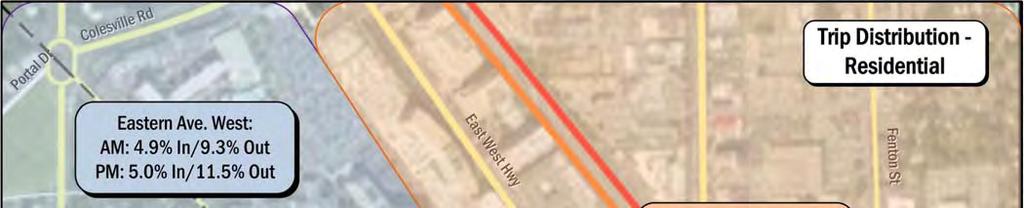
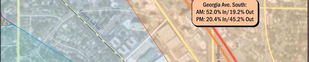
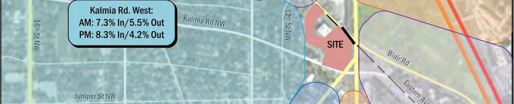
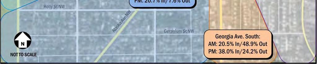
25 Figure 5: Residential Trip Distribution 21


26 Figure 6: Proposed Supermarket Service Area 22

27 Figure 7: Retail Trip Distribution 23
28 Table 7: Vehicular Capacity Analysis Results Intersection Approach Existing Conditions (2015) Future Background Conditions (2018) Total Future Conditions (2018) AM Peak Hour PM Peak Hour Sat PeakHour AM Peak Hour PM Peak Hour Sat Peak Hour AM Peak Hour PM Peak Hour Sat Peak Hour Delay LOS Delay LOS Delay LOS Delay LOS Delay LOS Delay LOS Delay LOS Delay LOS Delay LOS 14th St NW & Eastern Ave NW Overall 9.7 A 11.1 B 9.2 A 10.0 A 11.8 B 9.5 A 10.1 B 12.0 B 9.4 A Eastbound 9.5 A 10.8 B 9.1 A 9.8 A 11.3 B 9.4 A 9.9 A 11.5 B 9.5 A Westbound 10.2 B 12.1 B 9.5 A 10.5 B 13.2 B 9.8 A 10.7 B 13.4 B 10.0 B Northbound 8.5 A 9.4 A 8.2 A 8.6 A 9.7 A 8.4 A 8.7 A 9.8 A 8.4 A Southbound 9.0 A 9.5 A 8.5 A 9.5 A 9.9 A 8.8 A 9.6 A 9.9 A 8.8 A 13th St NW & Eastern Ave NW Overall 9.9 A 12.0 B 9.9 A 10.2 B 12.7 B 10.2 B 10.3 B 12.9 B 10.4 B Eastbound 10.3 B 13.5 B 10.2 B 10.7 B 14.4 B 10.6 B 10.8 B 14.8 B 10.8 B Westbound 10.2 B 11.7 B 10.3 B 10.4 B 12.3 B 10.6 B 10.5 B 12.5 B 10.8 B Northbound 8.8 A 10.5 B 9.2 A 8.9 A 10.8 B 9.3 A 9.0 A 11.0 B 9.5 A Southbound 9.3 A 10.2 B 9.1 A 9.5 A 10.4 B 9.3 A 9.5 A 10.5 B 9.4 A 12th St NW & Eastern Ave NW Westbound Left 0.3 A 0.4 A 0.7 A 0.3 A 0.4 A 0.7 A 0.3 A 0.4 A 0.7 A Northbound 12.1 B 11.9 B 10.9 B 12.4 B 12.2 B 11.0 B 12.5 B 12.2 B 11.1 B Alley Driveway/Parking Lot Entrance & Eastern Ave NW Eastbound Left 0.2 A 0.4 A 0.0 A 0.2 A 0.4 A 0.0 A 0.2 A 0.4 A 0.0 A Westbound Left 0.2 A 0.2 A 0.0 A 0.2 A 0.2 A 0.0 A 0.2 A 0.2 A 0.0 A Northbound 0.0 A 12.5 B 10.6 B 0.0 A 12.7 B 10.7 B 0.0 A 12.8 B 10.8 B Southbound 12.3 B 12.2 B 12.5 B 12.6 B 12.5 B 12.7 B 12.6 B 12.5 B 12.8 B Georgia Ave NW & Eastern Ave Overall 23.6 C 34.6 C 19.2 B 23.8 C 35.6 D 19.2 B 24.0 C 36.4 D 19.6 B Eastbound 41.4 D 26.6 C 26.6 C 41.6 D 26.7 C 26.5 C 41.7 D 26.7 C 26.5 C Westbound 44.8 D 29.9 C 30.2 C 44.8 D 30.0 C 30.2 C 44.8 D 30.0 C 30.2 C Northbound 22.2 C 40.6 D 8.6 A 22.2 C 42.6 D 8.6 A 23.1 C 44.0 D 9.3 A Southbound 14.9 B 29.9 C 22.6 C 15.0 B 30.0 C 22.7 C 15.2 B 30.6 C 23.1 C Blair Rd NW & Eastern Ave NW Overall 15.1 B 12.0 B 10.8 B 15.2 B 12.1 B 10.8 B 16.8 B 13.2 B 11.6 B Eastbound 7.6 A 7.6 A 7.5 A 7.6 A 7.6 A 7.5 A 7.7 A 7.8 A 7.7 A Northbound 19.4 B 14.3 B 12.3 B 19.5 B 14.4 B 12.4 B 22.5 C 16.6 B 13.9 B Southbound 10.4 B 10.1 B 9.5 A 10.4 B 10.1 B 9.5 A 10.4 B 10.1 B 9.5 A 16th St NW & Kalmia Rd NW Overall 15.5 B 14.1 B 24.6 C 15.7 B 14.2 B 25.2 C 16.4 B 15.2 B 28.4 C Eastbound 51.0 D 54.1 D 29.9 C 51.2 D 54.6 D 29.9 C 54.0 D 59.4 E 31.2 C Westbound 51.1 D 44.0 D 28.8 C 51.2 D 44.1 D 28.9 C 53.7 D 45.8 D 29.7 C Northbound 6.8 A 11.5 B 23.1 C 6.8 A 11.7 B 23.8 C 6.8 A 11.7 B 24.1 C Southbound 12.7 B 7.9 A 24.9 C 12.9 B 7.9 A 25.6 C 12.9 B 7.9 A 32.0 C 13th St NW & Kalmia Rd NW Overall 8.0 A 8.0 A 7.5 A 8.0 A 8.0 A 7.5 A 8.2 A 8.3 A 7.8 A Eastbound 8.1 A 8.3 A 7.7 A 8.1 A 8.3 A 7.7 A 8.3 A 8.6 A 8.0 A Westbound 8.1 A 7.7 A 7.4 A 8.2 A 7.7 A 7.4 A 8.3 A 8.0 A 7.8 A Northbound 7.8 A 7.8 A 7.5 A 7.9 A 7.9 A 7.5 A 8.0 A 8.0 A 7.6 A Southbound 7.7 A 7.9 A 7.4 A 7.7 A 7.9 A 7.4 A 7.9 A 8.1 A 7.7 A 12th St NW & Kalmia Rd NW Overall 7.8 A 7.9 A 7.3 A 7.8 A 7.9 A 7.4 A 8.0 A 8.3 A 7.7 A Eastbound 7.9 A 8.1 A 7.4 A 7.9 A 8.1 A 7.5 A 8.1 A 8.6 A 7.9 A Westbound 7.8 A 7.9 A 7.3 A 7.8 A 7.9 A 7.3 A 8.0 A 8.2 A 7.6 A 24
29 Existing Conditions (2015) Future Background Conditions (2018) Total Future Conditions (2018) Intersection Approach AM Peak Hour PM Peak Hour Sat PeakHour AM Peak Hour PM Peak Hour Sat Peak Hour AM Peak Hour PM Peak Hour Sat Peak Hour Delay LOS Delay LOS Delay LOS Delay LOS Delay LOS Delay LOS Delay LOS Delay LOS Delay LOS Northbound 7.7 A 7.7 A 7.2 A 7.7 A 7.7 A 7.2 A 7.8 A 8.0 A 7.4 A Southbound 7.6 A 7.7 A 7.3 A 7.6 A 7.7 A 7.3 A 7.7 A 7.9 A 7.6 A Kalmia Rd NW & Existing Driveway Eastbound Left 0.1 A 1.0 A 1.2 A 0.1 A 1.0 A 1.2 A Southbound 0.0 A 9.9 A 9.3 A 0.0 A 9.9 A 9.3 A Alaska Ave NW & Kalmia Rd NW Overall 24.4 C 68.3 E 23.5 C 24.5 C 70.0 E 23.6 C 28.9 C 71.4 E 30.5 C Eastbound 46.6 D 49.3 D 34.6 C 46.7 D 49.4 D 34.7 C 54.3 D 81.0 F 46.6 D Westbound 22.6 C 25.1 C 15.4 B 22.6 C 25.0 C 15.3 B 25.6 C 37.7 D 24.3 C Northbound 51.7 D F 44.3 D 51.7 D F 44.4 D 51.7 D F 44.4 D Southbound 5.2 A 13.3 B 2.9 A 5.2 A 13.3 B 3.0 A 5.5 A 13.8 B 3.7 A Georgia Ave NW & Kalmia Rd NW Overall 10.4 B 19.0 B 11.0 B 10.8 B 19.1 B 11.0 B 11.0 B 19.2 B 12.2 B Eastbound 0.6 A 8.1 A 0.5 A 0.6 A 8.0 A 0.5 A 0.9 A 4.3 A 0.8 A Westbound 45.1 D 44.1 D 34.2 C 45.1 D 44.1 D 34.2 C 46.2 D 45.4 D 35.2 D Northbound 12.8 B 20.8 C 17.0 B 12.8 B 21.0 C 17.1 B 13.4 B 23.2 C 20.0 C Southbound 8.0 A 20.7 C 2.7 A 8.6 A 20.8 C 2.7 A 8.5 A 20.7 C 2.8 A Georgia Ave NW & Geranium St NW Overall 21.1 C 8.2 A 6.6 A 21.2 C 8.1 A 6.6 A 21.0 C 8.8 A 6.6 A Eastbound 48.8 D 56.7 E 42.6 D 48.8 D 56.2 E 42.6 D 49.4 D 66.2 E 43.4 D Westbound 92.0 F 69.2 E 45.3 D 92.0 F 68.6 E 45.3 D 93.9 F 64.7 E 45.2 D Northbound 3.7 A 3.1 A 2.7 A 3.7 A 3.2 A 2.8 A 3.7 A 3.5 A 2.8 A Southbound 20.8 C 2.8 A 2.3 A 21.2 C 2.9 A 2.4 A 20.7 C 3.1 A 2.1 A 13th St NW & Geranium St NW Overall 7.6 A 7.3 A 7.2 A 7.6 A 7.3 A 7.2 A 7.7 A 7.4 A 7.2 A Eastbound 7.7 A 7.3 A 7.2 A 7.7 A 7.3 A 7.2 A 7.8 A 7.4 A 7.3 A Westbound 7.6 A 7.3 A 7.2 A 7.6 A 7.3 A 7.2 A 7.6 A 7.3 A 7.2 A Northbound 7.6 A 7.3 A 7.1 A 7.6 A 7.3 A 7.1 A 7.6 A 7.3 A 7.2 A Southbound 7.6 A 7.3 A 7.2 A 7.6 A 7.3 A 7.2 A 7.7 A 7.5 A 7.3 A Alaska Ave NW & 13th St NW & Hemlock St NW Overall 6.0 A 5.3 A 6.3 A 6.0 A 5.3 A 6.4 A 6.1 A 5.3 A 6.3 A Northbound 33.4 C 30.5 C 30.8 C 33.3 C 30.5 C 30.8 C 33.0 C 28.6 C 30.4 C Southbound 31.2 C 33.4 C 33.9 C 31.3 C 33.4 C 34.1 C 31.9 C 34.6 C 35.2 D Northeastbound 2.3 A 2.7 A 2.1 A 2.3 A 2.7 A 2.1 A 2.3 A 2.8 A 2.2 A Southwestbound 2.4 A 2.3 A 2.1 A 2.4 A 2.3 A 2.1 A 2.4 A 2.3 A 2.2 A Kalmia Rd NW & Site Driveway Eastbound Left 1.8 A 3.0 A 4.6 A Southbound 11.2 B 15.5 C 14.5 B 25
30 Table 8: Queuing Results Intersection Lane Group Storage Length (ft) Existing Conditions (2015) Future Background Conditions (2018) Total Future Conditions (2018) AM Peak PM Peak Sat Peak AM Peak PM Peak Sat Peak AM Peak PM Peak Sat Peak 50th % 95th % 50th % 95th % 50% 95% 50th % 95th % 50th % 95th % 50% 95% 50th % 95th % 50th % 95th % 50% 95% 12th St NW & Eastern Ave NW Eastbound TR Westbound LT Northbound LR Alley Drivewy/Parking Lot Entrance & Eastern Ave NW Eastbound LTR Westbound LTR Northbound LTR Southbound LTR Georgia Ave NW & Eastern Ave Eastbound LT Eastbound Right Westbound LT Westbound Right Northbound LTR ~504 # ~526 # ~547 # Southbound LTR ~304 #384 ~160 # ~308 #389 ~145 # ~327 #409 ~184 #284 Blair Rd NW & Eastern Ave NW Eastbound LR Northbound LT # # # # # # Southbound TR th St NW & Kalmia Rd NW Eastbound LTR Westbound LTR Northbound Left #62 Northbound TR # # Southbound Left Southbound TR # # #923 Kalmia Rd NW & Site Driveway Eastbound LT Westbound TR Southbound RL Alaska Ave NW & Kalmia Rd NW Eastbound TR # Westbound Left 25 4 m11 0 m2 3 m7 4 m12 0 m2 3 m7 4 m13 1 m1 3 m9 Westbound Thru m m Northbound Right ~147 # ~153 # ~153 # Southbound LTR m51 47 m38 0 m5 39 m53 47 m38 0 m0 42 m58 50 m48 0 m0 Georgia Ave NW & Kalmia Rd NW Eastbound LT m m m9 1 1 Eastbound Right m m m0 0 m0 Westbound LTR Northbound LTR Southbound LT m88 12 m m89 13 m m86 13 m17 Georgia Ave NW & Geranium St NW Eastbound LTR Westbound LTR Northbound LTR Southbound LTR Alaska Ave NW & 13th St NW & Hemlock St NW Eastbound LTR Westbound LTR Northbound LTR Southbound LTR
31 Figure 8: Proposed Improvements at Georgia Avenue/Alaska Avenue/Kalmia Road 27
32 Table 9: Mitigated Capacity Analysis Results Total Future Conditions (2018) Total Future Conditions (2018) with Mitigations Intersection Approach AM Peak Hour PM Peak Hour Sat Peak Hour AM Peak Hour PM Peak Hour Sat Peak Hour Delay LOS Delay LOS Delay LOS Delay LOS Delay LOS Delay LOS Georgia Ave NW & Eastern Ave Overall 24.0 C 36.4 D 19.6 B 28.4 C Eastbound 41.7 D 26.7 C 26.5 C No 32.8 C No Westbound 44.8 D 30.0 C 30.2 C Mitigations 37.1 D Mitigations Northbound 23.1 C 44.0 D 9.3 A Necessary 28.7 C Necessary Southbound 15.2 B 30.6 C 23.1 C 23.4 C 16th St NW & Kalmia Rd NW Overall 16.4 B 15.2 B 28.4 C 15.7 B Eastbound 54.0 D 59.4 E 31.2 C No 53.7 D No Westbound 53.7 D 45.8 D 29.7 C Mitigations 43.0 D Mitigations Northbound 6.8 A 11.7 B 24.1 C Necessary 13.1 B Necessary Southbound 12.9 B 7.9 A 32.0 C 8.9 A Alaska Ave NW & Kalmia Rd NW Overall 28.9 C 71.4 E 30.5 C 26.7 C 45.2 D 26.2 C Eastbound 54.3 D 81.0 F 46.6 D 45.7 D 42.7 D 36.2 D Westbound 25.6 C 37.7 D 24.3 C 21.0 C 16.4 B 19.2 B Northbound 51.7 D F 44.4 D 51.7 D 77.3 E 44.4 D Southbound 5.5 A 13.8 B 3.7 A 7.8 A 14.3 B 8.2 A Georgia Ave NW & Kalmia Rd NW Overall 11.0 B 19.2 B 12.2 B 12.7 B 20.1 B 12 B Eastbound 0.9 A 4.3 A 0.8 A 1.6 A 5.3 A 1.9 A Westbound 46.2 D 45.4 D 35.2 D 47.6 D 41.1 D 36.3 D Northbound 13.4 B 23.2 C 20.0 C 12.8 B 26.6 C 16.2 B Southbound 8.5 A 20.7 C 2.8 A 11.9 B 17.7 B 6.4 A Georgia Ave NW & Geranium St NW Overall 21.0 C 8.8 A 6.6 A 29.7 C 11.0 B 15.5 B Eastbound 49.4 D 66.2 E 43.4 D 45.8 D 43.5 D 33.4 C Westbound 93.9 F 64.7 E 45.2 D 54.7 D 42.5 D 34.4 C Northbound 3.7 A 3.5 A 2.8 A 6.3 A 9.6 A 7.4 A Southbound 20.7 C 3.1 A 2.1 A 39.0 D 5.4 A 20.3 C 28
33 TRANSIT This section discusses the existing and proposed transit facilities in the vicinity of the site, accessibility to transit, and evaluates the overall transit impacts due to the Shepherd Park development. The following conclusions are reached within this chapter: The development site is approximately 0.7 miles from the Silver Spring Metrorail station and is surrounded by several Metrobus routes that travel along multiple primary corridors. The site is expected to generate a manageable amount of transit trips, and the existing service is capable of handling these new trips. EXISTING TRANSIT SERVICE The study area is well served by both Metrorail and Metrobus. Combined, these transit services provide local, city wide, and regional transit connections and link the site with major cultural, residential, employment, and commercial destinations throughout the region. Figure 9 identifies the major transit routes, stations, and stops in the study area. The Silver Spring Metrorail station is located approximately 0.7 miles from the development site and is served by the Red Line. The Red Line travels south from Shady Grove, travels through downtown DC, and continues north to Glenmont. Trains run approximately every three minutes during the morning and afternoon peak periods. They run about every 5 to 6 minutes during weekday non peak periods, every 10 to 15 minutes on weekday evenings after 7 pm and 6 to 16 minutes on the weekends. The site is also serviced by Metrobus along multiple primary corridors. These bus lines connect the site to many areas of the District, including several Metrorail stations serving all of the six lines. Table 10 shows a summary of the bus route information for the routes that serve the site, including service hours, headway, and distance to the nearest bus stop. PROPOSED TRANSIT SERVICE Due to growth of population, jobs, and retail in several neighborhoods in the District and the potential for growth in other neighborhoods, the District s infrastructure is challenged with the need for transportation investments to support the recent growth and to further strengthen neighborhoods. In order to meet these challenges and capitalize on future opportunities, DDOT has developed a plan to identify transit challenges and opportunities and to recommend investments. This is outlined in DC s Transit Future System Plan report published by DDOT in April 2010, which includes the reestablishment of streetcar service in the District. The Priority Streetcar System includes a 9 mile north south corridor that will create a connection between the Buzzard Point/Southwest area and the Takoma/Silver Spring area. The final streetcar route has not yet been determined; however it is likely that it will travel along Georgia Avenue in the vicinity of Silver Spring with a stop location within a few blocks of the site. Table 10: Metrobus Route Information Route Number Route Name Service Hours Headway Walking Distance to Nearest Bus Stop 70 Georgia Avenue 7th Street Line Monday Saturday: 24 hour service Sundays: 4:10 am 3:00 am minutes < 0.1 miles (< 2 minutes) 79 Georgia Avenue Limited Line Monday Saturday: 6:00 am 7:50 pm 6 15 minutes < 0.1 miles (< 2 minutes) S2 16th Street Line Monday Saturday: 24 hour service Sundays: 4:30 am 2:15 am minutes < 0.1 miles (< 2 minutes) S9 16th Street Limited Line Weekdays: 6:30 am 10:35 am 3:00 pm 10:10 pm Saturdays: 6:30 am 10:35 am 3:00 pm 7:35 pm 6 15 minutes < 0.1 miles (< 2 minutes) 29
34 TRANSIT SITE IMPACTS Site Generated Transit Trips The proposed development is projected to generate 109 transit trips (52 inbound, 57 outbound) during the morning peak hour, 248 transit trips (133 inbound, 115 outbound) during the afternoon peak hour, and 264 transit trips (133 inbound, 131 outbound) during the Saturday peak hour. Additionally, Georgia Avenue/7 th Street is part of WMATA s Priority Corridor Network (PCN) and is identified as a high frequency local and regional bus corridor. As part of the PCN plan, potential improvements along this corridor include bus stop improvements, traffic signal adjustments, transit signal priority, dedicated bus lanes, and several additional service, operations, and management strategies. US Census data was used as a basis for determining the distribution of those taking Metrorail and those taking Metrobus. Based on the mode split information for Census Tract 103, 63 percent of transit riders utilize Metrobus and 37 percent utilize Metrorail. Given the transit trip generation of the development, approximately 40 people will use Metrorail and 69 will use Metrobus during the morning peak hour; approximately 92 people will use Metrorail and 156 will use Metrobus during the afternoon peak hour; and approximately 98 people will use Metrorail and 166 will use Metrobus during the Saturday peak hour. WMATA studied capacity of Metrorail stations in its Station Access & Capacity Study. The study analyzed the capacity of Metrorail stations for their vertical transportation, for example the capacity of the station at elevators, stairs, and escalators to shuttle patrons between the street, mezzanine, and platforms. The study also analyzed stations capacity to process riders at fare card gates. For both analyses, vertical transportation and fare card gates, volume to capacity ratios were calculated for existing data (from 2005) and projections for the year According to the study, high volume to capacity ratios were not observed at the Silver Spring Station in 2005 nor are they expected by WMATA also studied capacity along Metrobus routes. DC s Transit Future System Plan (2010) lists the bus routes with the highest load factor (a ratio of passenger volume to bus capacity). A load factor is considered unacceptable if it is over 1.2 during peak periods or over 1.0 during off peak or weekend periods. According to this study, both the 16 th Street Line and the Georgia Avenue/7 th Street Line exceed acceptable load factors. However, since this study was completed, limited stop service lines have been added to both lines. These limited stop lines have stops adjacent to the site and have shorter headways during the peak periods. Based on this information and the peak period headways of the surrounding Metrobus routes, it is not expected that site generated transit trips will cause detrimental impacts to Metrobus service. 30


35 Figure 9: Existing Transit Service 31
36 PEDESTRIAN FACILITIES This section summarizes the existing and future pedestrian access to the site and reviews walking routes to and from the site. The following conclusions are reached within this chapter: The existing pedestrian infrastructure surrounding the site provides an excellent walking environment. There are some barriers near the site, but overall there is a well connected pedestrian network. The site will improve the overall pedestrian environment on site by upgrading sidewalks along the perimeter of the site. PEDESTRIAN STUDY AREA Facilities within a quarter mile of the site were evaluated as well as routes to the Silver Spring Metrorail Station and the Walter Reed Army Medical Center. The site is easily accessible to multiple Metrobus stops along Georgia Avenue, Eastern Avenue, and Alaska Avenue. There are some barriers and areas of concern within the study area that negatively impact the quality of and attractiveness of the walking environment, such as the Red Line Metrorail tracks which create some limitations to the number of pedestrian connections available to the east. Most notably, the one mile stretch of Metrorail tracks between Burlington Avenue in Silver Spring and Cedar Street in Takoma Park only includes two locations where the tracks may be crossed in that segment. Figure 10 shows suggested pedestrian pathways, walking time and distances, and barriers or areas of concern. PEDESTRIAN INFRASTRUCTURE This section outlines the existing and proposed pedestrian infrastructure within the pedestrian study area. Existing Conditions A review of pedestrian facilities near the site shows that most facilities meet DDOT standards, and provide a quality walking Table 11: Sidewalk Requirements environment. Figure 11 shows a detailed inventory of the existing pedestrian infrastructure in the vicinity of the development site. Sidewalks, crosswalks, and curb ramps are evaluated based on the guidelines set forth by DDOT s Public Realm Design Manual in addition to ADA standards. Sidewalk width and buffer requirements for the District are shown below in Table 11. Within the area shown, most roads are considered residential with a low to moderate density, thus a 6 foot sidewalk with a 4 foot buffer is required. As can be seen in the figure, many sidewalks in the vicinity of the site comply with these standards; however there are a few areas that do not meet the minimum width or have no sidewalks at all. For the most part, these issues are not detrimental to the overall pedestrian experience as many of the roadways without sidewalks are not expected to be high volume pedestrian pathways. ADA standards require that all curb ramps be provided wherever an accessible route crosses a curb and must have a detectable warning. Additionally, curb ramps shared between two crosswalks is not desired. As shown in the figure, under existing conditions there are some issues with crosswalks and curb ramps near the site. SITE IMPACTS This section summarizes the impacts of the development on the overall pedestrian operations in the vicinity of the site. Pedestrian Trip Generation The planned development is expected to generate 65 walking trips (36 inbound, 29 outbound) during the morning peak hour, 164 walking trips (85 inbound, 79 outbound) during the afternoon peak hour, and 180 walking trips (92 inbound, 88 outbound) during the Saturday peak hour. The origins and destinations of these trips are likely to be: Residential neighborhoods, such as the apartment complexes in Silver Spring, Maryland and townhomes and single family homes in northern DC surrounding the site. These trips will primarily make up walking Street Type Minimum Sidewalk Width Minimum Buffer Width Residential (Low to Moderate Density) 6 ft 4 ft (6 ft preferred for tree space) Residential (High Density) 8 ft 4 ft (6 ft preferred for tree space) Commercial (Non downtown) 10 ft 4 ft Downtown 16 ft 6 ft 32
37 trips generated by the grocery store located on the ground floor of the development. Employment opportunities where Shepherd Park residents can walk to work, such as office buildings along Georgia Avenue and in Silver Spring, Maryland. Retail locations, such as the Blair Park Shopping Center and additional small retail establishments along the Georgia Avenue corridor. Based on these origins/destinations, most pedestrians generated by the Shepherd Park development will walk along Georgia Avenue to reach destinations north and south of the site. There will also be use of Eastern Avenue and East West Highway to reach additional locations within Silver Spring, Maryland. In addition to these trips, the transit trips generated by the site will also generate pedestrian demand between the Shepherd Park development and nearby transit stops. The majority of these transit riders will not leave the block the site is located on, as they will be utilizing the multiple Metrobus lines that have stops located directly adjacent to the site; however a about a third of the transit trips are expected to be allocated to Metrorail usage therefore will generate a small amount of pedestrian trips traveling to the Silver Spring Metrorail station. 33

38 Figure 10: Pedestrian Pathways 34

39 Figure 11: Existing Pedestrian Infrastructure 35
40 BICYCLE FACILITIES This section summarizes existing and future bicycle access, reviews the quality of cycling routes to and from the site, and presents recommendations. The following conclusions are reached within this chapter: The site has access to several on and off street bicycle facilities including the Metropolitan Branch Trail. An extension of the Metropolitan Branch Trail will be constructed which will provide an exclusive off street bicycle connection along the Red Line, stretching all the way to Union Station. The site is not expected to generate a significant amount of bicycle trips, therefore all site generated bike trips can be accommodated on existing infrastructure. The development site will include long term bicycle parking within the parking garages and short term bicycle parking within the site and along the perimeter of the site. EXISTING BICYCLE FACILITIES Within the study area, bicyclists have access to multi use trails, on street bike lanes, signed bicycle routes, and local and residential streets that facilitate cycling. The bicycle network provides good conditions for local trips and there are many different routes providing access to Maryland and many areas within the District. Accessible from the site is the Metropolitan Branch Trail which currently consists of off street trails and on street signed bicycle routes, with new additions and connections planned according to the Bicycle Master Plan prepared in Additionally there is an on street signed bicycle route along 8 th Street that travels southbound and leads to additional signed routes and bike lanes. There are some routes with barriers to cycling along them and entire roadway corridors that have poor cycling conditions that reduce the overall quality of cycling conditions and limit the number of routes that directly link the site without destination throughout the District and region. Figure 12 illustrates bicycle facilities in the study area and identifies street corridors with poor cycling conditions and the specific locations where there are barriers to cycling. This figure also depicts the projected routes to likely destinations within the area in addition to the distance and time it takes to get to these destinations assuming a speed of 12 miles per hour. Very little bicycle parking was observed in the study area causing most cyclists to use street signs, parking meters, or similar objects to secure their bicycles. This indicates that there is demand for additional bicycle parking facilities in the study area. In addition, the Capital Bikeshare program has placed over 350 bicycle share stations across Washington, DC, Arlington, VA, Alexandria, VA, and Montgomery County, MD with over 3,000 bicycles provided. Under existing conditions there is one Capital Bikeshare station located within a quarter mile of the site at the corner of 13 th Street and Eastern Avenue, with three additional stations located within a half mile of the site. PROPOSED BICYCLE FACILITIES The MoveDC plan outlines several bicycle improvements in the vicinity of the site. These improvements are broken up into four tiers that rank the priority for implementation. The four tiers are broken down as follows: Tier 1 Investments should be considered as part of DDOT s 6 year TIP and annual work program development, if they are not already included. Some projects may be able to move directly into construction, while others become high priorities for advancement through the Project Development Process. A bicycle trail from Stanton Road to Firth Sterling Avenue along Suitland Parkway will be in the tier 1 additions. Tier 2 Investments within this tier are not high priorities in the early years of MoveDC implementation. They could begin moving through the Project Development Process if there are compelling reasons for their advancement. There are a not tier 2 additions in the vicinity of the site. Tier 3 Investments within this tier are not priorities for DDOT led advancement in the early years of MoveDC s implementation. They could move forward earlier under circumstances such as real estate development initiatives 36
41 and non DDOT partnerships providing the opportunity for non District led completion of specific funding. Tier 4 Generally, investments within this tier are not priorities for DDOT led advancement and are lower priority for project development in the early years of implementation. Due to the timeline of the Shepherd Park development, this report focuses on the Tier 1 and Tier 2 recommendations within the vicinity of the site. This includes the 3.9 mile extension of the Metropolitan Branch Trail between Fort Totten and the Maryland State Line. This project is a Tier 1 recommendation that is funded and included in the TIP. SITE IMPACTS This section summarizes the impacts of the development on the overall bicycle operations surrounding the site and develops recommendations for connectivity improvements. Bicycle Trip Generation The planned development is expected to generate 20 bicycle trips (11 inbound, 9 outbound) during the morning peak hour, 53 bicycle trips (27 inbound, 26 outbound) during the afternoon peak hour, and 58 bicycle trips (30 inbound, 28 outbound) during the Saturday peak hour. Although bicycling will be an important mode for getting to and from the site, particularly with the nearby Metropolitan Branch Trail, the impacts from bicycling will be relatively less than impacts to other modes. On Site Bicycle Infrastructure To accommodate the bicycle trips to and from the site, the development will include 88 secure long term bicycle parking spaces within the first floor of the parking garage and 22 shortterm bicycle parking spaces located along the perimeter of the site. 37

42 Figure 12: Existing Bicycle Facilities 38
COMPREHENSIVE TRANSPORTATION REVIEW THE LADYBIRD
 COMPREHENSIVE TRANSPORTATION REVIEW THE LADYBIRD WASHINGTON, DC November 22, 2017 Prepared by: 1140 Connecticut Avenue NW Suite 600 Washington, DC 20036 Tel: 202.296.8625 Fax: 202.785.1276 3914 Centreville
2.0 Development Driveways. Movin Out June 2017
 Movin Out June 2017 1.0 Introduction The proposed Movin Out development is a mixed use development in the northeast quadrant of the intersection of West Broadway and Fayette Avenue in the City of Madison.
Traffic Impact Study Speedway Gas Station Redevelopment
 Traffic Impact Study Speedway Gas Station Redevelopment Warrenville, Illinois Prepared For: Prepared By: April 11, 2018 Table of Contents 1. Introduction... 1 2. Existing Conditions... 4 Site Location...
EXECUTIVE SUMMARY. The following is an outline of the traffic analysis performed by Hales Engineering for the traffic conditions of this project.
 EXECUTIVE SUMMARY This study addresses the traffic impacts associated with the proposed Shopko redevelopment located in Sugarhouse, Utah. The Shopko redevelopment project is located between 1300 East and
King County Metro. Columbia Street Transit Priority Improvements Alternative Analysis. Downtown Southend Transit Study. May 2014.
 King County Metro Columbia Street Transit Priority Improvements Alternative Analysis Downtown Southend Transit Study May 2014 Parametrix Table of Contents Introduction... 1 Methodology... 1 Study Area...
King Soopers #116 Thornton, Colorado
 Traffic Impact Study King Soopers #116 Thornton, Colorado Prepared for: Galloway & Company, Inc. T R A F F I C I M P A C T S T U D Y King Soopers #116 Thornton, Colorado Prepared for Galloway & Company
TRANSPORTATION REVIEW
 TRANSPORTATION REVIEW - PROPOSED MIX OF LAND USES IS CONSISTENT WITH THE CITY S UNDER THE GRANVILLE BRIDGE POLICIES THAT AIM TO MEET NEIGHBOURING RESIDENTS SHOPPING NEEDS AND REDUCE RELIANCE ON AUTOMOBILE
Traffic Impact Analysis West Street Garden Plots Improvements and DuPage River Park Garden Plots Development Naperville, Illinois
 Traffic Impact Analysis West Street Garden Plots Improvements and DuPage River Park Garden Plots Development Naperville, Illinois Submitted by April 9, 2009 Introduction Kenig, Lindgren, O Hara, Aboona,
appendix 4: Parking Management Study, Phase II
 appendix 4: Parking Management Study, Phase II A4-1 A4-2 Eastlake Parking Management Study Final Phase 2 Report Future Parking Demand & Supply January 6, 2017 Submitted by Denver Corp Center III 7900 E.
RE: A Traffic Impact Statement for a proposed development on Quinpool Road
 James J. Copeland, P.Eng. GRIFFIN transportation group inc. 30 Bonny View Drive Fall River, NS B2T 1R2 May 31, 2018 Ellen O Hara, P.Eng. Project Engineer DesignPoint Engineering & Surveying Ltd. 200 Waterfront
Craig Scheffler, P.E., PTOE HNTB North Carolina, P.C. HNTB Project File: Subject
 TECHNICAL MEMORANDUM To Kumar Neppalli Traffic Engineering Manager Town of Chapel Hill From Craig Scheffler, P.E., PTOE HNTB North Carolina, P.C. Cc HNTB Project File: 38435 Subject Obey Creek TIS 2022
APPENDIX VMT Evaluation
 APPENDIX 2.7-2 VMT Evaluation MEMORANDUM To: From: Mr. Jonathan Frankel New Urban West, Incorporated Chris Mendiara LLG, Engineers Date: May 19, 2017 LLG Ref: 3-16-2614 Subject: Villages VMT Evaluation
LAWRENCE TRANSIT CENTER LOCATION ANALYSIS 9 TH STREET & ROCKLEDGE ROAD / 21 ST STREET & IOWA STREET LAWRENCE, KANSAS
 LAWRENCE TRANSIT CENTER LOCATION ANALYSIS 9 TH STREET & ROCKLEDGE ROAD / 21 ST STREET & IOWA STREET LAWRENCE, KANSAS TRAFFIC IMPACT STUDY FEBRUARY 214 OA Project No. 213-542 TABLE OF CONTENTS 1. INTRODUCTION...
Planned Development Application 1450 Sherman Avenue Evanston, IL TRAFFIC CIRCULATION IMPACT STUDY
 Planned Development Application 1450 Sherman Avenue Evanston, IL 60201 14 TRAFFIC CIRCULATION IMPACT STUDY Traffic Impact Study 1454 Sherman Mixed-Use Development Evanston, Illinois Prepared for Prepared
Bi-County Transitway/ Bethesda Station Access Demand Analysis
 Bi-County Transitway/ Bethesda Station Access Demand Analysis Prepared for: Washington Metropolitan Area Transit Authority Office of Planning and Project Development May 2005 Prepared by: in conjunction
Transportation & Traffic Engineering
 Transportation & Traffic Engineering 1) Project Description This report presents a summary of findings for a Traffic Impact Analysis (TIA) performed by A+ Engineering, Inc. for the Hill Country Family
TABLE OF CONTENTS 1.0 INTRODUCTION AND SUMMARY Purpose of Report and Study Objectives... 2
 TABLE OF CONTENTS 1.0 INTRODUCTION AND SUMMARY 1 1.1 Purpose of Report and Study Objectives... 2 1.2 Executive Summary... 3 1.2.1 Site Location and Study Area... 3 1.2.2 Development Description... 3 1.2.3
INDUSTRIAL DEVELOPMENT
 INDUSTRIAL DEVELOPMENT Traffic Impact Study Plainfield, Illinois August 2018 Prepared for: Seefried Industrial Properties, Inc. TABLE OF CONTENTS Executive Summary 2 Introduction 3 Existing Conditions
NAVY YARD BALLPARK STATION ACCESS IMPROVEMENTS STUDY. Final Report. Washington Metropolitan Area Transit Authority
 NAVY YARD BALLPARK STATION ACCESS IMPROVEMENTS STUDY Final Report Washington Metropolitan Area Transit Authority Office of Real Estate and Station Planning April 2016 [This page intentionally left blank]
Traffic Engineering Study
 Traffic Engineering Study Bellaire Boulevard Prepared For: International Management District Technical Services, Inc. Texas Registered Engineering Firm F-3580 November 2009 Executive Summary has been requested
Alpine Highway to North County Boulevard Connector Study
 Alpine Highway to North County Boulevard Connector Study prepared by Avenue Consultants March 16, 2017 North County Boulevard Connector Study March 16, 2017 Table of Contents 1 Summary of Findings... 1
LCPS Valley Service Center
 Traffic Impact Study LCPS Valley Service Center Loudoun County, Virginia November 4, 2015 Prepared For: Loudoun County Public Schools 21000 Education Court Ashburn, VA 20148 Prepared by: 1140 Connecticut
Address Land Use Approximate GSF
 M E M O R A N D U M To: Kara Brewton, From: Nelson\Nygaard Date: March 26, 2014 Subject: Brookline Place Shared Parking Analysis- Final Memo This memorandum presents a comparative analysis of expected
APPENDIX C1 TRAFFIC ANALYSIS DESIGN YEAR TRAFFIC ANALYSIS
 APPENDIX C1 TRAFFIC ANALYSIS DESIGN YEAR TRAFFIC ANALYSIS DESIGN YEAR TRAFFIC ANALYSIS February 2018 Highway & Bridge Project PIN 6754.12 Route 13 Connector Road Chemung County February 2018 Appendix
HUMC/Mountainside Hospital Redevelopment Plan
 Traffic and Parking Analysis HUMC/Mountainside Hospital Redevelopment Plan in Glen Ridge Borough and Montclair Township PREPARED FOR H2M 119 Cherry Hill Road, Suite 110 Parsippany, NJ 07054 862.207.5900
TRAFFIC IMPACT ANALYSIS
 TRAFFIC IMPACT ANALYSIS Emerald Isle Commercial Development Prepared by SEPI Engineering & Construction Prepared for Ark Consulting Group, PLLC March 2016 I. Executive Summary A. Site Location The Emerald
4131 Chain Bridge Road
 Traffic Impact Study 4131 Chain Bridge Road City of Fairfax, VA 05/04/16 May 4, 2016 Prepared for: Paradigm 1415 North Taft Street Suite 100 Arlington, VA 22201 This report is printed on environmentally
Proposed location of Camp Parkway Commerce Center. Vicinity map of Camp Parkway Commerce Center Southampton County, VA
 Proposed location of Camp Parkway Commerce Center Vicinity map of Camp Parkway Commerce Center Southampton County, VA Camp Parkway Commerce Center is a proposed distribution and industrial center to be
TIMBERVINE TRANSPORTATION IMPACT STUDY FORT COLLINS, COLORADO JANUARY Prepared for:
 TIMBERVINE TRANSPORTATION IMPACT STUDY FORT COLLINS, COLORADO JANUARY 2014 Prepared for: Hartford Companies 1218 W. Ash Street Suite A Windsor, Co 80550 Prepared by: DELICH ASSOCIATES 2272 Glen Haven Drive
MILLERSVILLE PARK TRAFFIC IMPACT ANALYSIS ANNE ARUNDEL COUNTY, MARYLAND
 MILLERSVILLE PARK TRAFFIC IMPACT ANALYSIS ANNE ARUNDEL COUNTY, MARYLAND Prepared for: Department of Public Works Anne Arundel County Prepared by: URS Corporation 4 North Park Drive, Suite 3 Hunt Valley,
Traffic Impact Analysis. Alliance Cole Avenue Residential Site Dallas, Texas. Kimley-Horn and Associates, Inc. Dallas, Texas.
 Traffic Impact Analysis Alliance Cole Avenue Residential Site Dallas, Texas February 15, 2018 Kimley-Horn and Associates, Inc. Dallas, Texas Project #064524900 Registered Firm F-928 Traffic Impact Analysis
West Hills Shopping Centre Lowe s Expansion Traffic Impact Study
 West Hills Shopping Centre Lowe s Expansion Traffic Impact Study Prepared for: Armel Corporation January 2015 Paradigm Transportation Solutions Ltd. 22 King Street South, Suite 300 Waterloo ON N2J 1N8
TRAFFIC SIGNAL DESIGN REPORT KING OF PRUSSIA ROAD & RAIDER ROAD RADNOR TOWNSHIP PENNSYLVANIA
 TRAFFIC SIGNAL DESIGN REPORT KING OF PRUSSIA ROAD & RAIDER ROAD RADNOR TOWNSHIP PENNSYLVANIA PREPARED FOR: UNIVERSITY OF PENNSYLVANIA HEALTH SYSTEM 34 CIVIC CENTER BOULEVARD PHILADELPHIA, PA 1987 (61)
ANDERSON PROPERTY SITE ANALYSIS
 ANDERSON PROPERTY SITE ANALYSIS Introduction The Montgomery County Department of Transportation (MCDOT) initiated a feasibility study in the fall of 2012 to evaluate the need for transit service expansion
Lacey Gateway Residential Phase 1
 Lacey Gateway Residential Phase Transportation Impact Study April 23, 203 Prepared for: Gateway 850 LLC 5 Lake Bellevue Drive Suite 02 Bellevue, WA 98005 Prepared by: TENW Transportation Engineering West
Section 5.0 Traffic Information
 Section 5.0 Traffic Information 10.0 TRANSPORTATION MDM Transportation Consultants, Inc. (MDM) has prepared an evaluation of transportation impacts for the proposed evaluation for the expansion of the
Traffic Impact Study for Proposed Olive Boulevard Development
 Traffic Impact Study for Proposed 11330 Olive Boulevard Development Creve Coeur, Missouri July 7, 2017 Prepared For: 11330 Olive Boulevard Development 11330 Olive Boulevard Creve Coeur, Missouri 63141
BROWARD BOULEVARD CORRIDOR TRANSIT STUDY
 BROWARD BOULEVARD CORRIDOR TRANSIT STUDY FM # 42802411201 EXECUTIVE SUMMARY July 2012 GOBROWARD Broward Boulevard Corridor Transit Study FM # 42802411201 Executive Summary Prepared For: Ms. Khalilah Ffrench,
IV. ENVIRONMENTAL IMPACT ANALYSIS K.2. PARKING
 IV. ENVIRONMENTAL IMPACT ANALYSIS K.2. PARKING ENVIRONMENTAL SETTING The following analysis summarizes the findings and conclusions of the Traffic Analysis (Traffic Study), prepared by The Mobility Group,
TRAFFIC IMPACT ANALYSIS SHORTBREAD LOFTS 2009 MODIFICATION Chapel Hill, North Carolina
 TRAFFIC IMPACT ANALYSIS SHORTBREAD LOFTS 2009 MODIFICATION Chapel Hill, North Carolina Prepared for: The Town of Chapel Hill, NC Prepared by: Architects-Engineers-Planners, Inc. November 2009 Traffic Impact
APPENDIX E. Traffic Analysis Report
 APPENDIX E Traffic Analysis Report THIS PAGE INTENTIONALLY BLANK EAGLE RIVER TRAFFIC MITIGATION PHASE I OLD GLENN HIGHWAY/EAGLE RIVER ROAD INTERSECTION IMPROVEMENTS TRAFFIC ANALYSIS Eagle River, Alaska
Table Existing Traffic Conditions for Arterial Segments along Construction Access Route. Daily
 5.8 TRAFFIC, ACCESS, AND CIRCULATION This section describes existing traffic conditions in the project area; summarizes applicable regulations; and analyzes the potential traffic, access, and circulation
Appendix C. Traffic Study
 Appendix C Traffic Study TABLE OF CONTENTS SECTION Executive Summary PAGE 1.0 Introduction... 1 1.1 Scope of Work... 1 1.2 Study Area... 2 2.0 Project Description... 3 2.1 Site Access... 4 2.2 Pedestrian
APPENDIX C-2. Traffic Study Supplemental Analysis Memo
 APPENDIX C-2 Traffic Study Supplemental Analysis Memo The Mobility Group Transportation Strategies & Solutions Memorandum To: From: Subject: Tomas Carranza, LADOT Matthew Simons Traffic Review - Revised
CORE AREA SPECIFIC PLAN
 only four (A, B, D, and F) extend past Eighth Street to the north, and only Richards Boulevard leaves the Core Area to the south. This street pattern, compounded by the fact that Richards Boulevard is
West Rosslyn Development
 Traffic Impact Study and Transportation Management Plan West Rosslyn Development Arlington County, VA Revised: January 11, 2017 May 10, 2016 Prepared for: Penzance 2400 N Street, NW, Suite 600 Washington,
THE CORNERSTONE APARTMENTS TRAFFIC IMPACT STUDY R&M PROJECT NO
 THE CORNERSTONE APARTMENTS SITUATED AT N/E/C OF STAUDERMAN AVENUE AND FOREST AVENUE VILLAGE OF LYNBROOK NASSAU COUNTY, NEW YORK TRAFFIC IMPACT STUDY R&M PROJECT NO. 2018-089 September 2018 50 Elm Street,
Escondido Marriott Hotel and Mixed-Use Condominium Project TRAFFIC IMPACT ANALYSIS REPORT
 Escondido Marriott Hotel and Mixed-Use Condominium Project TRAFFIC IMPACT ANALYSIS REPORT Prepared for Phelps Program Management 420 Sixth Avenue, Greeley, CO 80632 Prepared by 5050 Avenida Encinas, Suite
Downtown Lee s Summit Parking Study
 Downtown Lee s Summit Parking Study As part of the Downtown Lee s Summit Master Plan, a downtown parking and traffic study was completed by TranSystems Corporation in November 2003. The parking analysis
BERKELEY DOWNTOWN AREA PLAN PROGRAM ENVIRONMENTAL IMPACT REPORT TRAFFIC IMPACT ANALYSIS
 BERKELEY DOWNTOWN AREA PLAN PROGRAM ENVIRONMENTAL IMPACT REPORT TRAFFIC IMPACT ANALYSIS Prepared for: City of Berkeley Prepared by: REVISED JANUARY 9, 2009 Berkeley Downtown Area Plan Program EIR Traffic
MINERVA PARK SITE TRAFFIC IMPACT STUDY M/I HOMES. September 2, 2015
 5500 New Albany Road Columbus, Ohio 43054 Phone: 614.775.4500 Fax: 614.775.4800 Toll Free: 1-888-775-EMHT emht.com 2015-1008 MINERVA PARK SITE TRAFFIC IMPACT STUDY M/I HOMES September 2, 2015 Engineers
EXECUTIVE SUMMARY. The valet operation, service area, and drop-off lanes provided will be adequate Page i
 EXECUTIVE SUMMARY MacKenzie Engineering and Planning, Inc. performed an analysis of the traffic impacts resulting from the proposed project site located at 25 SE 4th Avenue, Delray Beach, Florida (PCN
7359 WISCONSIN AVENUE MONTGOMERY COUNTY, MARYLAND
 7359 WISCONSIN MONTGOMERY COUNTY, MARYLAND September 1, 2017 7359 Wisconsin Avenue September 2017 7359 WISCONSIN Local Area Transportation Review Montgomery County, Maryland September 1, 2017 Prepared
Transportation Land Development Environmental S e r v i c e s
 Transportation Land Development Environmental S e r v i c e s Memorandum To: Ms. Kristin E. Kassner Planning Director Town Hall Annex 25 Center Street Burlington, MA 01803 Date: September 23, 2013 Project
Re: Addendum No. 4 Transportation Overview 146 Mountshannon Drive Ottawa, Ontario
 April 18 th, 2017 Mr. Kevin Yemm Vice President, Land Development Richraft Group of Companies 2280 St. Laurent Boulevard, Suite 201 Ottawa, Ontario (Tel: 613.739.7111 / e-mail: keviny@richcraft.com) Re:
TRANSPORTATION STUDY FOR THE 8899 BEVERLY BOULEVARD PROJECT
 DRAFT TRANSPORTATION STUDY FOR THE 8899 BEVERLY BOULEVARD PROJECT WEST HOLLYWOOD, CALIFORNIA NOVEMBER 2013 PREPARED FOR BEVERLY BOULEVARD ASSOCIATION PREPARED BY DRAFT TRANSPORTATION STUDY FOR THE 8899
Traffic Feasibility Study
 Traffic Feasibility Study Town Center South Robbinsville Township, Mercer County, New Jersey December 19, 2017 Prepared For Robbinsville Township Department of Community Development 2298 Route 33 Robbinsville,
BARRHAVEN FELLOWSHIP CRC 3058 JOCKVALE ROAD OTTAWA, ONTARIO TRANSPORTATION BRIEF. Prepared for:
 BARRHAVEN FELLOWSHIP CRC 3058 JOCKVALE ROAD OTTAWA, ONTARIO TRANSPORTATION BRIEF Prepared for: Barrhaven Fellowship CRC 3058 Jockvale Road Ottawa, ON K2J 2W7 December 7, 2016 116-649 Report_1.doc D. J.
Table of Contents INTRODUCTION... 3 PROJECT STUDY AREA Figure 1 Vicinity Map Study Area... 4 EXISTING CONDITIONS... 5 TRAFFIC OPERATIONS...
 Crosshaven Drive Corridor Study City of Vestavia Hills, Alabama Table of Contents INTRODUCTION... 3 PROJECT STUDY AREA... 3 Figure 1 Vicinity Map Study Area... 4 EXISTING CONDITIONS... 5 TRAFFIC OPERATIONS...
TRAFFIC IMPACT STUDY. USD #497 Warehouse and Bus Site
 TRAFFIC IMPACT STUDY for USD #497 Warehouse and Bus Site Prepared by: Jason Hoskinson, PE, PTOE BG Project No. 16-12L July 8, 216 145 Wakarusa Drive Lawrence, Kansas 6649 T: 785.749.4474 F: 785.749.734
IRSCH REEN Hirsch/Green Transportation Consulting, Inc.
 IRSCH REEN Hirsch/Green Transportation Consulting, Inc. February 6, 2013 Mr. David Weil Director of Finance St. Matthew s Parish School 1031 Bienveneda Avenue Pacific Palisades, California 90272 RE: Trip
Construction Realty Co.
 MEMORANDUM TO: FROM : Jeff Pickus Construction Realty Co. Luay R. Aboona, PE Principal 9575 West Higgins Road, Suite 400 Rosemont, Illinois 60018 p: 847-518-9990 f: 847-518-9987 DATE: May 22, 2014 SUBJECT:
Subarea Study. Manning Avenue (CSAH 15) Corridor Management and Safety Improvement Project. Final Version 1. Washington County.
 Corridor Management and Safety Improvement Project. Final Version 1. Washington County.") Subarea Study Manning Avenue (CSAH 15) Corridor Management and Safety Improvement Project Final Version 1 Washington County June 12, 214 SRF No. 138141 Table of Contents Introduction... 1 Forecast Methodology
Subarea Study Manning Avenue (CSAH 15) Corridor Management and Safety Improvement Project Final Version 1 Washington County June 12, 214 SRF No. 138141 Table of Contents Introduction... 1 Forecast Methodology
TECHNICAL MEMORANDUM. Part A: Introduction
 TECHNICAL MEMORANDUM To: David J. Decker Decker Properties, Inc. 5950 Seminole Centre Ct. Suite 200 Madison, Wisconsin 53711 608-663-1218 Fax: 608-663-1226 www.klengineering.com From: Mike Scarmon, P.E.,
L1TILE BEARS DAY CARE TRANSPORTATION IMPACT STUDY FORT COLLINS, COLORADO MAY Prepared for:
 L1TILE BEARS DAY CARE TRANSPORTATION IMPACT STUDY FORT COLLINS, COLORADO MAY 2012 Prepared for: Hillside Construction, Inc. 216 Hemlock Street, Suite B Fort Collins, CO 80534 Prepared by: DELICH ASSOCIATES
US 29 Bus Rapid Transit Planning Board Briefing. February 16, 2017
 US 29 Bus Rapid Transit Planning Board Briefing February 16, 2017 Project Goals Improve the quality of transit service Improve mobility opportunities and choices Enhance quality of life Support master
MONTEREY BAY AQUARIUM RESEARCH INSTITUTE (MBARI) MASTER PLAN UPDATE MOSS LANDING, CALIFORNIA
 MASTER PLAN UPDATE MOSS LANDING, CALIFORNIA") MONTEREY BAY AQUARIUM RESEARCH INSTITUTE (MBARI) MASTER PLAN UPDATE MOSS LANDING, CALIFORNIA TRAFFIC IMPACT ANALYSIS Administrative Draft Report Prepared For Monterey Bay Aquarium Research Institute Moss
MONTEREY BAY AQUARIUM RESEARCH INSTITUTE (MBARI) MASTER PLAN UPDATE MOSS LANDING, CALIFORNIA TRAFFIC IMPACT ANALYSIS Administrative Draft Report Prepared For Monterey Bay Aquarium Research Institute Moss
Oakbrook Village Plaza City of Laguna Hills
 Oakbrook Village Plaza City of Laguna Hills Traffic Impact Analysis Prepared by: HDR Engineering 3230 El Camino Real, Suite 200 Irvine, CA 92602 October 2012 Revision 3 D-1 Oakbrook Village Plaza Laguna
Clean Harbors Canada, Inc.
 Clean Harbors Canada, Inc. Proposed Lambton Landfill Expansion Environmental Assessment Terms of Reference Transportation Assessment St. Clair Township, Ontario September 2009 itrans Consulting Inc. 260
GLEBE 672 TRAFFIC IMPACT ANALYSIS ARLINGTON COUNTY, VIRGINIA. Section 1 INTRODUCTION 1
 GLEBE 672 TRAFFIC IMPACT ANALYSIS ARLINGTON COUNTY, VIRGINIA TABLE OF CONTENTS Page Section 1 INTRODUCTION 1 Section 2 BACKGROUND INFORMATION 6 Public Road Network... 6 Non Auto Facilities and Services...
Trip Generation Study: Provo Assisted Living Facility Land Use Code: 254
 Trip Generation Study: Provo Assisted Living Facility Land Use Code: 254 Introduction The Brigham Young University Institute of Transportation Engineers (BYU ITE) student chapter completed a trip generation
INTERSECTION ANALYSIS PARK AVENUE AND BRADDOCK ROAD (FROSTBURG, MD) FOR LENHART TRAFFIC CONSULTING, INC.
 FOR LENHART TRAFFIC CONSULTING, INC.") INTERSECTION ANALYSIS FOR PARK AVENUE AND BRADDOCK ROAD (FROSTBURG, MD) Prepared for: City of Frostburg, Maryland & Allegany County Commissioners Prepared by: LENHART TRAFFIC CONSULTING, INC. TRAFFIC ENGINEERING
INTERSECTION ANALYSIS FOR PARK AVENUE AND BRADDOCK ROAD (FROSTBURG, MD) Prepared for: City of Frostburg, Maryland & Allegany County Commissioners Prepared by: LENHART TRAFFIC CONSULTING, INC. TRAFFIC ENGINEERING
EXECUTIVE SUMMARY. Introduction
 EXECUTIVE SUMMARY Introduction The purpose of this study is to ensure that the Village, in cooperation and coordination with the Downtown Management Corporation (DMC), is using best practices as they plan
Traffic Impact Statement (TIS)
") Traffic Impact Statement (TIS) Vincentian PUDA Collier County, FL 10/18/2013 Prepared for: Global Properties of Naples Prepared by: Trebilcock Consulting Solutions, PA 2614 Tamiami Trail N, Suite 615 1205
Traffic Impact Statement (TIS) Vincentian PUDA Collier County, FL 10/18/2013 Prepared for: Global Properties of Naples Prepared by: Trebilcock Consulting Solutions, PA 2614 Tamiami Trail N, Suite 615 1205
TRAFFIC IMPACT STUDY FOR SONIC DRIVE-IN RESTAURANT. Vallejo, CA. Prepared For:
 TRAFFIC IMPACT STUDY FOR SONIC DRIVE-IN RESTAURANT Vallejo, CA Prepared For: ELITE DRIVE-INS, INC. 2190 Meridian Park Blvd, Suite G Concord, CA 94520 Prepared By: KD Anderson & Associates 3853 Taylor Road,
Trip Generation & Parking Occupancy Data Collection: Grocery Stores Student Chapter of Institute of Transportation Engineers at UCLA Spring 2014
 Trip Generation & Parking Occupancy Data Collection: Grocery Stores Student Chapter of Institute of Transportation Engineers at UCLA Spring 2014 Page 1 Introduction The UCLA Institute of Transportation
Existing Traffic Conditions
 May 14, 2014 Ms. Lorraine Weiss City of San Mateo 330 West 20 th Avenue San Mateo, CA 94403 Subject: Traffic Operational Study for the Proposed Tilton Avenue Residential Development in San Mateo, California
Chevy Chase Lake. Preliminary Plan # B TRAFFIC STATEMENT. Prepared for: Chevy Chase Land Company & Bozzuto Development Company
 Chevy Chase Lake Preliminary Plan # 12002020B TRAFFIC STATEMENT Prepared for: Chevy Chase Land Company & Bozzuto Development Company Montgomery County, Maryland Prepared by: SSSTS Consulting (410) 718-8660
METRO Orange Line BRT American Boulevard Station Options
 METRO Orange Line BRT American Boulevard Station Options Bloomington City Council Work Session November 18, 2013 Christina Morrison BRT/Small Starts Project Office Coordinating Planning and Design AMERICAN
TORONTO TRANSIT COMMISSION REPORT NO.
 Form Revised: February 2005 TORONTO TRANSIT COMMISSION REPORT NO. MEETING DATE: October 24, 2012 SUBJECT: DOWNTOWN RAPID TRANSIT EXPANSION STUDY (DRTES) PHASE 1 STRATEGIC PLAN ACTION ITEM RECOMMENDATIONS
Trip Generation and Parking Study New Californian Apartments, Berkeley
 Trip Generation and Parking Study New Californian Apartments, Berkeley Institute of Transportation Engineers University of California, Berkeley Student Chapter Spring 2012 Background The ITE Student Chapter
TRAFFIC IMPACT ANALYSIS. for MILTON SQUARE
 TRAFFIC IMPACT ANALYSIS for MILTON SQUARE US Route 7 Milton, Vermont March 5, 2008 LAMOUREUX & DICKINSON 14 Morse Drive Essex Junction, Vermont 05452 (802) 878-4450 Traffic Impact Assessment EXECUTIVE
RTE. 1 at RTE. 637 & RTE. 639
 INTERSECTION SAFETY STUDY Prepared for: Virginia Department of Transportation Central Region Operations Traffic Engineering (UPC #81378, TO 12-092) DAVENPORT Project Number: 13-368 / /2014 RTE. 1 at RTE.
King Street & Wyman Road Transportation Impact Study & Transportation Demand Management. Paradigm Transportation Solutions Limited
 King Street & Wyman Road Transportation Impact Study & Transportation Demand Management Paradigm Transportation Solutions Limited April 28 Project Summary Project Number 822 April 28 Client RISE Commercial
LEED v4 Building Design and Construction Quiz #3 LT
 LEED v4 Building Design and Construction Quiz #3 LT 1. How are walking and bicycling distance measured? A. Straight-line radius from a main building entrance B. Straight-line radius from any building entrance
MEMO VIA . Ms. Amy Roth DPS Director, City of Three Rivers. To:
 MEMO To: Ms. Amy Roth DPS Director, City of Three Rivers VIA EMAIL From: Michael J. Labadie, PE Julie M. Kroll, PE, PTOE Brandon Hayes, PE, P.Eng. Fleis & VandenBrink Date: January 5, 2017 Re: Proposed
Executive Summary EXECUTIVE SUMMARY Parking Issues Trenton Downtown Parking Policy and Sidewalk Design Standards E.S. Page 1 Final Report 2008
 EXECUTIVE SUMMARY A walkable environment that accommodates market demand while minimizing the negative impacts of growth is an important element in promoting the City s downtown revitalization. There are
Executive Summary. Draft Environmental Impact Statement/Environmental Impact Report ES-1
 Executive Summary Introduction The Eastside Transit Corridor Phase 2 Project is a vital public transit infrastructure investment that would provide a transit connection to the existing Metro Gold Line
Mercer Island Center for the Arts Parking Management Plan
 Parking Stalls Mercer Island Center for the Arts Parking Management Plan June 15, 2016 This Parking Management Plan (P) covers all tenants at the Mercer Island Center for the Arts (MICA) campus, including
Vanier Parkway and Presland Road Residential Development Transportation Impact Study
 Vanier Parkway and Presland Road Residential Development Transportation Impact Study Final Report (Revised) March 2011 Submitted to: Groupe Lépine Ottawa Project No. 09-1613 Submitted by: Groupe Lépine
Volume 1 Traffic Impact Analysis Turtle Creek Boulevard Dallas, Texas. Kimley-Horn and Associates, Inc. Dallas, Texas.
 Volume 1 Traffic Impact Analysis 2727 Dallas, Texas June 18, 2018 Kimley-Horn and Associates, Inc. Dallas, Texas Project #064523000 Registered Firm F-928 Traffic Impact Analysis 2727 Dallas, Texas Prepared
Develop ground transportation improvements to make the Airport a multi-modal regional
 Project Overview TRANSPORTATION IMPROVEMENTS WHAT ARE THE PROJECT GOALS? Transportation transportation hub. Develop ground transportation improvements to make the Airport a multi-modal regional Land Use
CLRP. Performance Analysis of The Draft 2014 CLRP. Long-Range Transportation Plan For the National Capital Region
 NATIONAL CAPITAL REGION TRANSPORTATION PLANNING BOARD Item 12 CLRP Financially Constrained Long-Range Transportation Plan For the National Capital Region 2014 Performance Analysis of The Draft 2014 CLRP
I-820 (East) Project Description. Fort Worth District. Reconstruct Southern I-820/SH 121 Interchange
 Project Description. Fort Worth District. Reconstruct Southern I-820/SH 121 Interchange") I-820 (East) Project Description Fort Worth District Reconstruct Southern I-820/SH 121 Interchange I-820 from approximately 2,000 feet north of Pipeline Road/Glenview Drive to approximately 3,200 feet
I-820 (East) Project Description Fort Worth District Reconstruct Southern I-820/SH 121 Interchange I-820 from approximately 2,000 feet north of Pipeline Road/Glenview Drive to approximately 3,200 feet
Parks and Transportation System Development Charge Methodology
 City of Sandy Parks and Transportation System Development Charge Methodology March, 2016 Background In order to implement a City Council goal the City of Sandy engaged FCS Group in January of 2015 to update
V. DEVELOPMENT OF CONCEPTS
 Martin Luther King, Jr. Drive Extension FINAL Feasibility Study Page 9 V. DEVELOPMENT OF CONCEPTS Throughout the study process several alternative alignments were developed and eliminated. Initial discussion
RE: Taggart Retail Site Plan: Kanata West Proposal for Traffic Impact Study: Addendum #2
 1223 Michael Street, Suite 100, Ottawa, Ontario K1J 7T2 Tel: 613.738.4160 Fax: 613.739.7105 www.delcan.com July 9, 2014 OUR REF: TO3073TOK00 BY EMAIL: jparkes@taggart.ca/aturner@taggart.ca Taggart Commercial
FINAL. Sound Transit Long-Range Plan Update. Issue Paper S.1: Tacoma Link Integration with Central Link. Prepared for: Sound Transit
 Sound Transit Long-Range Plan Update Issue Paper S.1: Tacoma Link Integration with Central Link Prepared for: Sound Transit Prepared by: Quade & Douglas, Inc. FINAL March 2005 Foreword This issue paper
Green Line Long-Term Investments
 Enhancements Short-term improvements to keep Austin moving. Investments Long-term projects to support our future. Mobility Hubs MetroRapid MetroRail MetroExpress Connectors Circulators Project Connect
IMPROVEMENT CONCEPTS
 IMPROVEMENT CONCEPTS for the South Novato Transit Hub Study Prepared by: January 11, 2010 DKS Associates With Wilbur Smith Associates IMPROVEMENT CONCEPTS Chapter 1: Introduction 1. INTRODUCTION The strategic