2. ALTERNATIVES CONSIDERED
|
|
|
- Clifford Wade
- 5 years ago
- Views:
Transcription
1 2. ALTERNATIVES CONSIDERED 2.1 INTRODUCTION This chapter describes the decision process to develop alternatives, identify screening criteria, screen alternatives, and identify a Build Alternative. For details on the project s Purpose and Need, description, history, and relevance to past planning studies, refer to Chapter 1, Purpose and Need. Identification of a range of alternatives began with the scoping and screening processes. These are preliminary steps to identify and evaluate candidate project alternatives in past transportation studies relevant to the North Metro corridor study area. Five levels of screening were conducted. Alternatives that performed most favorably against the screening evaluation criteria in each step are described in detail as Build Alternatives. The No Action Alternative, which is required by NEPA, is also included (the No Action Alternative is defined in Section 2.3.1, No Action Alternative). Capital and operating and maintenance costs for each alternative are described briefly in this chapter. The impacts of implementing the alternatives are included in Chapter 3, Affected Environment and Environmental Consequences, and Chapter 4, Transportation. A summary of the overall evaluation of the alternatives to recommend the Preferred Alternative is included in Chapter 5, Evaluation of Alternatives Considered. 2.2 SCOPING AND SCREENING OF ALTERNATIVES Scoping The scoping process is the first step in the EIS process, as required by NEPA and SAFETEA-LU. The scoping process links planning with NEPA. The scoping process was initiated when the project s Notice of Intent (NOI) was published in the Federal Register (FR) on 12 September Scoping brings together the concerns and interests of the public, affected agencies, and other interested parties. Through these discussions, a range of actions and alternatives are developed, evaluation criteria are identified, and environmental effects and mitigation measures are analyzed. Scoping provides a firm basis for the decision-making process and helps ensure that a comprehensive and focused EIS will be prepared. The primary result of the scoping process is the development of a range of initial alternatives to be screened and carried forward for analysis in the EIS. The Draft EIS Scoping Results Report (URS 2007) documents the input received from the scoping process. A summary of the major issues from the public meetings is provided in Chapter 6, Public Comment and Agency Coordination Past Studies Affecting the Planning Process New Federal Highway Administration (FHWA)/FTA policy, Linking the Transportation Planning and National Environmental Policy Act (NEPA) Processes (FHWA/FTA 2005), encourages the use of previous transportation studies in the NEPA process. The previous studies and plans with public participation most influencing the Project (as described in Chapter 1, Purpose and Need) include: 2-1 November 2009
2 North Metro Transportation Study (North Metro Major Investment Study) (RTD 2001) Included DMU rail transit or electrified LRT on the UP Boulder Branch Alignment from DUS to 124 th Avenue in Thornton. (This study recommendation was prior to the requirement for FRA crash-compliant vehicles.) FasTracks Plan, approved by the voters in November 2004 and adopted by the RTD Board of Directors in April 2004 (RTD 2004) Recommended commuter rail on the BNSF and UP alignments from DUS to the 162 nd Avenue area. DRCOG Metro Vision 2030 Plan (2006a), adopted in 2005 and amended in 2006 Incorporated a rapid transit rail line on the UP Boulder Branch Alignment from DUS to the 162 nd Avenue area. These studies and plans included Public Involvement Programs (PIPs) to solicit input. In addition to the study and plans described above, RTD completed the Three Corridors Scoping Study (2005) to address additional technical and engineering questions in three FasTracks corridors, including North Metro. The primary purpose was to identify the most workable location for transit components, including the necessary land requirements for the transit alignments and station locations. The study resulted in a refined North Metro alignment that used a portion of the BNSF Railway corridor (Brush Subdivision) for access to DUS, and extended the northern end of the corridor to 162 nd Avenue, from the previously proposed end-ofline at 124 th Avenue identified in the North Metro Transportation Study (RTD 2001). The Three Corridors Scoping Study (RTD 2005) was a technical analysis and did not include public input. Figure 2-1 illustrates the BNSF and UP alignments considered in past studies, which form the alignments under consideration in this project Alternatives Development Each alternative developed for the Project contains a set of elements organized to achieve the project goals. The supporting elements include the alignment locations, required infrastructure (including stations), and particular vehicle technologies that support the North Metro service concept to provide high-capacity fixed-guideway transit. North Metro s alternatives also considered how to access RTD s proposed CRMF site. Using the aforementioned studies and plans as a baseline, and input from the scoping process, the following assumptions were applied to develop alternatives: All North Metro Transportation Study (RTD 2001) alternatives are reconsidered, except those that do not meet Purpose and Need. The alternatives must provide high-capacity line-haul service (back and forth between common terminus points) within the North Metro corridor study area. The alternatives need to provide local access and station stops within the North Metro corridor study area. Alternative alignments should limit property acquisition. Alternative alignments and stations should serve as many activity centers as possible. Alternative alignments must connect to DUS and the end-of-line near 162 nd Avenue in Thornton. November


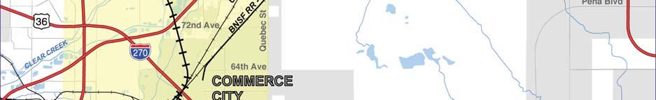
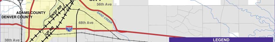
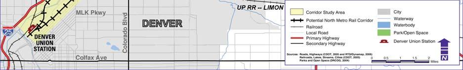
3 FIGURE 2-1. NORTH METRO CORRIDOR STUDY AREA 2-3 November 2009
4 For consistency in evaluation, all alternatives include eight station target areas in addition to DUS, generally located in Denver s Globeville/Elyria/Swansea area, Commerce City, 88 th Avenue, Thornton Parkway to 104 th Avenue, 112 th Avenue, 124 th Avenue, 144 th Avenue, and 162 nd Avenue neighborhoods. Similar to the fixed-guideway transit component of the North Metro Transportation Study (RTD 2001) LPA, a minimum all-day service frequency of 30 minutes was assumed along the entire corridor, with additional service during the peak period. NEPA requires that a No Action Alternative be included in the evaluation. The No Action Alternative assumes that the proposed project would not be implemented. The effects or conditions resulting from the No Action Alternative provide a baseline from which to compare the effects of the proposed Build Alternative. In addition to the No Action Alternative, FTA requires consideration of a Transportation Systems Management (TSM) Alternative to maximize the efficiency of the existing transportation system in urbanized areas without a major investment. The TSM Alternative is considered a Build Alternative but is generally a lower cost option, such as improved bus service. Alternatives development is detailed in this section according to alignments, technology, stations, and transit service strategies. Stations serving the alternatives are fully described in Section 2.3.3, Build Alternative. The North Metro corridor study area was organized into two sections to simplify the alternatives analysis process and related descriptions in this document. The Southern Section begins at the DUS access point near 20 th Street and proceeds to 84 th Avenue. The Northern Section is between 84 th Avenue and the 162 nd Avenue area, just north of SH Alignment Alternatives The previous studies noted earlier identified the UP Alignment consisting of the Greeley Subdivision south of Sand Creek Junction, and the BNSF Alignment consisting of the Brush Subdivision south of Sand Creek Junction, as the two most reasonable North Metro railway corridors to consider for connecting Denver to Commerce City and all points north. These two UP and BNSF mainlines cross at-grade at Sand Creek Junction. The UP Boulder Branch north of Sand Creek Junction was determined to be the most appropriate alignment for connecting communities to the north. While the UP Greeley Subdivision (both north and south of Sand Creek Junction) was considered, the UP Boulder Branch appeared to be more reasonable for the connections in the north, since the UP Greeley Subdivision corridor does not provide access to the communities of Northglenn and Thornton. Additionally, 10 to 15 freight trains pass through the Greeley Subdivision each day carrying automobiles, inter-modal, grain, and general merchandise, while the UP Boulder Branch serves one customer with as few as twenty 3-car trains per year. In the summer of 2009, RTD agreed to purchase the UP Boulder Branch ROW. Although the UP Railroad no longer owns this rail alignment, for the purposes of this document, it will continue to be referred to as the UP Boulder Branch. The UP Boulder Branch stretches 33 miles from Sand Creek Junction in Commerce City to the Valmont Power Plant in Boulder. However, a railway bridge over I-25 along this alignment has been removed. Alternatives to the BNSF and UP alignments were introduced during public scoping. These included an I-25 alignment and a Washington Street alignment. In addition, the previously November
5 described UP Greeley Subdivision corridor from DUS to Brighton was suggested. These are illustrated on Figure 2-2. As a result of the scoping process, the following conceptual alignment alternatives were investigated: UP Railroad Alignment (which consists of the UP Greeley Subdivision to the UP Boulder Branch) BNSF/UP Boulder Branch Railroad Alignment (which consists of the BNSF Brush Subdivision to the UP Boulder Branch) I-25 corridor Washington Street corridor (two options) UP Greeley Subdivision from DUS to Brighton Additional Alignments in Southern Section Early in the project, RTD recognized a need to bypass a heavily congested railroad junction in the Southern Section of the corridor. The BNSF Brush Subdivision and UP Greeley Subdivision cross each other at-grade while crossing over Sand Creek and under I-270 at a constrained area known as Sand Creek Junction (see Figure 2-3 for an illustration of Sand Creek Junction and the bypass alternatives). Alternatives were developed that considered either going through or over Sand Creek Junction or bypassing it to the west or east. The early numbering convention for these alignment options depended on whether the alignment began in the UP Railroad corridor (using 1 as a prefix with the lettered alignment, such as 1-A or 1-B), or the BNSF Railway corridor (using 2 as a prefix, such as 2-A or 2-B). The alignment options included A, going through, over, or directly adjacent to the junction; B, C, and D, bypassing on the west side of Sand Creek Junction; and E and F, bypassing on the east side of Sand Creek Junction. Alignments B, C, and D are referred to as the cross-country alignments in this study. During additional refinements, multiple variations of alignment options A and B were developed. Since the project began, a number of events occurred where RTD needed to consider new alignments or reevaluate alignments previously set aside. In January 2008, RTD and the UP Railroad Company could not reach terms over the purchase of several critical pieces of UP Railroad property south of Commerce City. Key property included the UP line into DUS and UP s 36 th Street railyard, which RTD would have used for its CRMF location. Due to the high cost of this section, two other alternatives outside but adjacent to the UP Alignment, and two alternatives in the BNSF corridor were reconsidered. The BNSF corridor alternatives included either using the BNSF ROW, or paralleling outside of the BNSF ROW, on the east side. The two modified UP Alignment alternatives are referred to as West of the Railyard and Over the Railyard. The UP West of the Railyard Alignment alternative uses the proposed East corridor rail line (outside the UP ROW) from DUS to 31 st Street, and then swings to the east slightly and then to the west to cross over the proposed East corridor and UP rail lines to run along the west side of the UP Railyard. From the Railyard, it crosses over I-70 and York Street, and then to avoid Sand Creek Junction, curves west under the BNSF before it connects to the cross-country alignments B, C, or D. The UP Over the Railyard Alignment alternative is similar, but at 31 st Street, stays within the proposed East corridor ROW until it crosses on structure over the UP Railyard, I-70, and York Street, and then follows the same alignment as described for the UP West of the Railyard alternative (see Figure 2-3 for an illustration of Sand Creek Junction and the bypass alternatives). 2-5 November 2009

6 FIGURE 2-2. CONCEPTUAL ALIGNMENTS CONSIDERED November


7 FIGURE 2-3. SOUTHERN SECTION ALIGNMENTS TO COMMERCE CITY Source: Project Team, November 2009
8 Subsets of the A alignment were also developed for the BNSF Brush Subdivision when other alternative costs increased, and the vehicle technology improved and could handle steeper grades. The previous A alignment had to go over I-270 and/or Sand Creek Junction due to grades. With the steeper grade allowance, two versions of a modified BNSF Brush Subdivision s A alignment were developed to go under I-270 and west of Sand Creek Junction. The 2-A-2 alignment (at-grade) was defined to extend along a portion of Brighton Boulevard south of I-270 at grade, and the 2-A-3 alignment (on-structure) was defined to be elevated along the same segment of Brighton Boulevard to avoid select street and rail crossings. The 2-A-2 alignment continues along the BNSF Brush Subdivision and at Riverside Cemetery crosses over to the east side of the BNSF, then goes on the east side of Brighton Boulevard/ SH 265 up to approximately 56 th Avenue where it crosses over 56 th Avenue and to the west side of BNSF Railway on bridge structure. It then runs at-grade on the east side of Brighton Boulevard and west of the BNSF through the Suncor Energy (U.S.A.) Inc. (Suncor) refinery area. It ties into the UP Boulder Branch north of Sand Creek Junction. The 2-A-3 alignment, generally at-grade on the east side of the BNSF Brush Subdivision from DUS, becomes elevated when it splits off from the B alignments at Riverside Cemetery. It follows the same alignment as 2-A-2 except it would remain elevated along Brighton Boulevard/ SH 265 (on the east side of the road) above the railroad spurs into the Suncor refinery, touching down and crossing under I-270, then running at-grade just west of Sand Creek Junction before tying into the UP Boulder Branch Alignment south of 64 th Avenue. The 2-A-2 and 2-A-3 alignment names were later shortened to A-2 and A-3, and are described that way hereafter. See Figure 2-12 for a typical section of the elevated portion of A-3. Additional General Alignments During scoping, some of the public suggested improving the east to west connectivity within the North Metro corridor study area. These options included roadway improvements and a fixedguideway commuter rail circumferential connection with RTD s Northwest Rail, Gold Line, North Metro, and East corridors somewhere north of DUS. Citizens recommended that a segment of Quebec Street be used from an unspecified location north of I-70 to 72 nd Avenue, where North Metro would turn west to return to the UP Boulder Branch corridor. This alternative was suggested as a way to address the difficulties of connecting Denver and Commerce City, and to serve several key activity centers in Commerce City. The citizens who suggested this route believed the Quebec Street corridor would better serve the residents of Commerce City and would showcase recent redevelopment that has occurred over the past 10 years including the Rocky Mountain Arsenal National Wildlife Refuge, a new soccer stadium, a new city municipal building, and the new Adams City High School Technology Alternatives The UP Railroad has formally documented that, if passenger rail vehicles do not meet FRA compliance standards for vehicle safety, they will not be allowed to operate alongside freight rail vehicles within UP Railroad ROW. The BNSF Railway Company has provided no formal statement but has implied a similar policy. November
9 LRT technology does not comply with FRA vehicle safety standards, and with the position of each of the railroad companies, LRT cannot be implemented within the active freight railroad ROWs. The FRA-compliant commuter rail technologies that would be considered for the BNSF or UP alignments are FRA-compliant DMU and EMU. In addition to LRT technology and commuter rail technology (EMU and DMU), locomotive hauled coaches (LHC), bus rapid transit (BRT), subway, monorail, third rail (an electrified rail along the tracks to power the trains), double-decker DMU or EMU, and streetcar were suggested technologies. Roadway and fixedguideway commuter rail improvements to provide east to west connectivity were also suggested by the public. During the conceptual alternatives development process of the Project, appropriate rail technology alternatives were matched with the alignments. LRT was considered for all the alignments outside the railroad ROW, but DMU and EMU were only considered applicable to the UP Alignment, the BNSF/UP Boulder Branch Alignment, and the UP Greeley Subdivision railroad corridors. The DMU and EMU vehicle technologies were not considered along the I-25 corridor due to limitations on their operation on the existing grades along the highway, nor along Washington Street, because introducing an interface of heavier rail technology with automobile traffic would be unsafe and not compatible with traffic when LRT is the standard application. All alternatives are shown in Table 2-1. TABLE 2-1. ALIGNMENT AND TECHNOLOGY ALTERNATIVES Alignment and Technology Alternatives No Action Alternative Transportation System Management/Travel Demand Management (TSM/TDM) Light Rail Transit Technology Paralleling UP Railroad (UP Greeley/UP Boulder Branch) on West Paralleling BNSF/UP Boulder Branch on West Paralleling UP Railroad Greeley Subdivision on East or West Paralleling Interstate 25 on West On Washington Street in Median On Washington Street in Median with Traffic Lane Reduction Diesel Multiple Unit (DMU) Technology UP Alignment (UP Greeley/UP Boulder Branch) BNSF/UP Boulder Branch UP Railroad Greeley Electric Multiple Unit (EMU) Technology UP Alignment (UP Greeley/UP Boulder Branch) BNSF/UP Boulder Branch UP Railroad Greeley Other Alternatives Locomotive Hauled Coaches Bus Rapid Transit Streetcar Monorail Subway Third Rail Double-decker DMU or EMU 2-9 November 2009
10 TABLE 2-1. ALIGNMENT AND TECHNOLOGY ALTERNATIVES Alignment and Technology Alternatives East to West Connections Roadway East to West Circumferential Commuter Rail Quebec Street Source: Project Team, Note: UP = Union Pacific Screening results are described fully in Section 2.2.4, Screening Process, but in summary, only DMU and EMU technologies were advanced to the DEIS full analysis Station Options The North Metro corridor has eight station target areas. Multiple station options were developed and evaluated for the target areas. For the final Preferred Alternative, only one option would be selected at each target area, for a total of eight stations. The process for selecting a station site and developing options for it is briefly described here. The general public and representatives of the cities and counties that would benefit from the stations were included in the process through a series of station planning meetings. Stations are generally sited within a community that can provide sufficient ridership, provide property that can be acquired for the station, and possibly support future transit oriented development (TOD) around the station. It is desirable for commuter rail stations to be approximately 2 miles apart. Criteria for station site selection include mobility and engineering feasibility. For example, the station should improve overall mobility and depending on the type of station, be convenient to a major roadway with a nearby signalized intersection. Engineering criteria require that platforms are placed on a straight and level segment of track, provide level passenger boarding, and should be a minimum of 300 feet from where the tracks cross a road. Site selection also considers if the station should be a local, neighborhood walk-up style, or a regional commuter park-n-ride. In siting the station and developing the station footprint, the characteristics of the site were considered to minimize impacts. In this chapter, the station options are fully described within the context of the Build Alternative (see Section 2.3.3, Build Alternative) Transit Service Strategies The transit service strategy for all potential North Metro corridor study area alternatives is based on maintaining and enhancing the current transit networks, improving travel time, accommodating long-term demand, expanding coverage and access, and ensuring regional service integration. Elements and actions associated with each of these broad guidelines are described in the following paragraphs. In the Southern Section of the North Metro corridor study area, the street network is primarily a grid, facilitating the existing transit service of local and limited-stop buses. The North Metro corridor study area is served by downtown Denver-focused and north-south crosstown local and limited-stop buses. This service provides connectivity to northeast Denver. Northern suburbs November
11 within the North Metro corridor study area have a less well-connected, curvilinear street network. This area is served by express service buses at park-n-rides and a less-dense network of local buses, and demand responsive service (call-n-ride). The existing transit network configuration, as described, would be maintained and enhanced by all alternatives. Additional parking and transit transfer locations would be established with any North Metro fixed-guideway transit technology alternative so that access to and between transit facilities would be direct and logical. With the exception of the north-south crosstown buses, downtown Denver would be the primary travel destination and the southern terminus for the majority of transit service from the North Metro corridor study area. In any alternative, this connectivity provides access to regional rail and other local and regional transit services. Within the North Metro corridor study area, local buses would connect activity centers, and additional local services would be added to feed transit users from northern suburban areas to park-n-rides Commuter Rail Maintenance Facility The Build Alternative must also access RTD s CRMF site. The CRMF is a connected action to North Metro. Several locations were proposed for the CRMF before the Fox North Site was selected. The Fox North Site is adjacent to railroad ROW that would serve the future Gold Line and Northwest Rail commuter rail corridors. The UP north yard and the BNSF trailer-on-flatcar (TOFC) yard are west of the proposed CRMF site, and an Owens Corning manufacturing facility is on the east. The Commuter Rail Maintenance Facility Supplemental Environmental Assessment to FasTracks Commuter Rail Corridors (FTA and RTD 2009) serves as a supplement for the Gold Line DEIS (FTA 2008) and East Corridor DEIS (FTA 2009). Commuter Rail Maintenance Facility Refinements after the Supplemental Environmental Assessment Public Hearing A Public Hearing was held on 23 April 2009 to present the results of the Commuter Rail Maintenance Facility Supplemental Environmental Assessment to FasTracks Commuter Rail Corridors (FTA and RTD 2009). The potential acquisition of the Owens Corning facility was the issue that received the majority of the comments opposing the site. Other possible impacts, such as the acceptance of the site to the surrounding neighborhoods, the effects of the shared alignment, and the impacts of the CRMF itself on the environment were not major public concerns. Many comments from Owens Corning employees were received. Almost in entirety, the Owens Corning employees and management believed that RTD had under-estimated the cost of relocating the Owens Corning facility, that the facility would close, and that all of the Owens Corning jobs, as well as indirect employment related to Owens Corning operations, would be lost. In response to concerns about the potential loss of jobs, RTD redesigned the CRMF to minimize the impact on the Owens Corning facilities. This involved some modifications to the original design and operational criteria to reduce the site size and avoid the acquisition of approximately 9 acres of the Owens Corning site, allowing the administration and plant operating facilities to remain intact. Owens Corning could potentially lose some outside storage area and some parking that would need to be relocated as a part of this project. Figure 2-4 depicts the revised site plan November 2009
12 FIGURE 2-4. RTD COMMUTER RAIL MAINTENANCE FACILITY CONCEPT Source: CRMF Project Team, November
13 2.2.4 Screening Process The screening process initially included three levels of screening, with the intent to select the most feasible alignment(s), vehicle technology, and station options for further analysis in the DEIS. Two advanced screening steps (Level 4 and Level 5) were added for the Southern Section to address issues that surfaced during the study process. These issues were partly due to the complexity of the Southern Section but also due to the higher than anticipated costs for ROW for some alternatives. Station options and vehicle technology were also addressed in more detail during the final screening steps. This section describes the initial screening levels for the entire corridor and the advanced screening levels that were further required for the Southern Section alignments. The overall screening process is illustrated in Figure November 2009

14 FIGURE 2-5. ALTERNATIVES SCREENING PROCESS Source: Project Team, November
15 Alignment and Technology Screening Levels Full details for the first screening efforts for alignments and technology are available in the Level 1 and Level 2 Alternatives Evaluation Report (RTD 2007), and the Level 3 Alternatives Evaluation and Screening Report/RTD Annual Program Evaluation (RTD 2008a). The evaluation criteria that were used are summarized in Table 2-2. TABLE 2-2. SUMMARY OF ALTERNATIVES EVALUATION CRITERIA Level 1 Criteria Level 2 Criteria Level 3 Criteria Level 4 Criteria Level 5 Criteria Does the alternative concept meet project Purpose? Does the alternative meet project Need? Focus: Screen initial list of alignment alternatives and vehicle technologies. Evaluate station target areas. Fulfillment of Purpose and Need at Level 1. Affordability. Mobility improvements. Environmental impacts. Community Impacts/benefits. Compatibility with related plans/ projects. Degree of community support. Degree of agency support. Focus: Screen refined list of alignment alternatives and technologies. Source: Project Team, Notes: DMU = diesel multiple unit DUS = Denver Union Station EMU = electric multiple unit ROW = right-of-way UP = Union Pacific Fulfills Purpose and Need at Level 1 and Level 2. Cost/affordability. Technical feasibility/ compatibility. Mobility improvements. Environmental impacts. Transit supportive land use and future patterns. Compatibility with related projects. Degree of community support. Degree of agency support. Focus: Evaluate UP and BNSF alignments from DUS to 84 th Avenue; evaluate cross-country alignments; and evaluate all station options. Evaluate DMU and EMU vehicle technologies. Same criteria as Level 3. Some detailed criteria specific to Level 4 were also used, such as specific residential or business impacts. Focus: Further evaluate crosscountry alignments; further evaluate station options. Evaluate DMU and EMU vehicle technologies. Mobility improvements. Guideway costs. Railroad ROW impacts. ROW/property impacts. Environmental justice impacts. Public/agency support. Focus: Re-evaluate modified UP and BNSF alignments from DUS to Commerce City; evaluate BNSF station options; evaluate modified/ refined station options in remainder of corridor. Evaluate DMU and EMU vehicle technologies November 2009

16 At each screening level, RTD and the project team considered and addressed project concerns and opportunities that the public and government agencies had brought to attention during a series of public and local government/agency meetings. At the conclusion of each level of screening, the results were shared at follow-up milestone meetings for the public, the Local Governments Team (LGT), and the Agency Working Group (AWG). The AWG included the joint lead agencies of RTD and FTA, cooperating and participating agencies, and the railroads. The following information describes the screening levels in brief. Screening Level 1. Level 1 screened a broad range of alignment alternatives according to whether they met Purpose and Need. Using Purpose and Need as the evaluation criteria, this level focused on evaluating roadway (I-25 and Washington Street) and rail corridor alignments and a broad spectrum of vehicle technologies, including EMU, DMU, LRT, LHC, BRT, monorail, third rail, streetcar, and subway. Station target areas were also reviewed. Commuter rail technology (EMU and DMU) within or along the UP and BNSF/UP Boulder Branch Alignment alternatives, LRT within or adjacent to the railroad alignment alternatives, and LRT along I-25 and Washington Street corridors were advanced to the next screening level because they met the project Purpose and Need. The TSM Alternative, and the UP and BNSF alignments out of DUS were also advanced. For information on the alternatives eliminated in Screening Level 1, refer to Table 2-3. Screening Level 2 continued the evaluation of vehicle technology and rail corridor alignments, as well as the TSM Alternative, to determine degrees of effectiveness for achieving project goals. Through criteria that evaluated affordability, mobility improvements, basic environmental impacts, community impacts and benefits, and compatibility with related projects, it identified key trade-offs and advanced the most promising alignments and vehicle technologies, which were the BNSF/UP Boulder Branch Alignment and the UP Alignment. Commuter rail technology was selected over LRT and all other technologies during this level of screening. These recommendations were primarily due to the availability of ROW and conceptual level costs. Station target areas were further reviewed. November

 Level 3 also further evaluated the commuter rail technology that was advanced from Level 2 screening.")
17 Screening Level 3. This screening level applied detailed evaluation criteria to the base criteria described in the Level 2 screening. This screening level concentrated on the UP, BNSF, and the project s Southern Section alignments, A and cross-country alignment options B-1, B-2, B-3, B-4, C, D, E, and F. One of these alignments would provide the connection between DUS and the BNSF/UP Boulder Branch in Commerce City. (See Figure 2-3 for the alignments.) Level 3 also further evaluated the commuter rail technology that was advanced from Level 2 screening. The quantitative (measure-based) analysis in Level 3 formed the basis for the Build Alternative and included conceptual cost estimates, mobility benefits, and environmental impacts. By Level 3, multiple station concepts had been introduced for each station target area, and the station evaluation process became more detailed. At the conclusion of Level 3 screening, the UP Alignment from DUS was recommended to connect to the UP Boulder Branch in Commerce City, and alignments A, B-1, B-2, B-3, B-4, C, and D were advanced to Screening Level 4. Screening Level 4. Due to the numerous and complex Southern Section alignments (A, B-1, B-2, B-3, B-4, C, and D) designed to bypass the congested Sand Creek Junction area from the UP Alignment in the project s Southern Section south of Commerce City, the project team added a Level 4 evaluation process to the alternatives analysis. Level 4 screening focused on the alignments designed to bypass the Sand Creek Junction crossing in the Southern Section. Level 4 screening was also applied to the high number of station options in the entire corridor and further evaluated the commuter rail technologies that were advanced from Level 3 screening. The Level 4 evaluation process used criteria similar to Level 3 primary criteria, and specifically focused on residential and business impacts. This screening reduced the number of alignments and stations in the Southern Section. The B alignment options were advanced for further consideration because they had less community impact. The results of the Level 4 screening are detailed in the Level 4 Evaluation and Screening Report (RTD 2008b) November 2009

18 Screening Level 5. At the conclusion of Level 3 screening, the entire UP Alignment (UP Greeley/UP Boulder Branch) had been selected for the North Metro Build Alternative. In January 2008, RTD and the UP Railroad Company could not reach terms over the purchase of several critical pieces of UP property south of Commerce City. Subsequently, RTD determined it should re-evaluate the use of either the UP or BNSF alignments between DUS and the Denver County/Adams County line. The cost to acquire UP Railroad property was much higher than anticipated, especially the area RTD desired for its CRMF. This greatly increased the cost of the UP Alignment alternative and the CRMF location, and resulted in RTD s reconsideration of previous facility locations, and evaluation of modified alternatives. A new CRMF location was proposed (the CRMF location is evaluated in a separate study, the Commuter Rail Maintenance Facility Supplemental Environmental Assessment to FasTracks Commuter Rail Corridors, [FTA and RTD 2009]). The modified BNSF Alignment alternative in the Southern Section placed the commuter rail alignment outside but paralleling adjacent to the BNSF ROW. The modified UP Alignment alternatives in the Southern Section used the proposed East corridor ROW (outside the UP ROW) and then avoided UP s 36 th Street Railyard by either going west of or over the railyard. A Level 5 screening step was undertaken by North Metro to re-evaluate modified UP Railroad Alignment versus the BNSF Alignment in the Southern Section, out of DUS. Level 5 incorporated some primary Level 3 criteria, but focused on ROW and property impacts and costs, as listed in Table 2-2. While the modified UP Alignments provided slightly more attractive mobility benefits and slightly lower construction costs due to sharing with the East corridor, the modified BNSF Alignment has lower ROW impacts (i.e., similar full commercial acquisitions but no residential impacts). The UP alignments have five to 16 full residential impacts. A modified version of the BNSF Alignment was therefore recommended. It proposes paralleling the east side of the BNSF ROW. New station options within Denver were also introduced along the BNSF corridor and were evaluated using Level 5 screening criteria. The results are detailed in the Level 5 UP Railroad and BNSF Alignment Reevaluation Report (RTD 2008c), and the Level 5 BNSF Station Options Screening Report (RTD 2008d). LRT Alternatives were reevaluated and the results are described in Section , Light Rail Transit Alternative(s). Summary of Screening Results through Early Spring 2009 The No Action Alternative was advanced through all levels of screening, and it is fully evaluated in the DEIS as required by NEPA. The Build Alternative was designed to include several components after screening. First, a modified version of the BNSF Alignment in the Southern Section was selected to join the UP Boulder Branch Alignment north of Sand Creek Junction (hence, the naming convention of BNSF/UP Boulder Branch Alignment for the Build Alternative). Second, of the Sand Creek Junction bypass alignments, B-2, B-3, and B-4 were advanced for further consideration because they had less community impact. Third, the commuter rail technology (DMU or EMU) will continue to be evaluated, and will be selected at the conclusion November
19 of the DEIS. Finally, of the more than four dozen station options for the eight station target areas, 15 are fully analyzed in the DEIS. Reevaluation of the A Alignments In May 2009, RTD decided to re-evaluate the practicality of the previously screened-out BNSF corridor A alignments (see the end of Section , Alignment Alternatives, for details), because preliminary engineering completed for the B-2, B-3, and B-4 alignments showed many difficulties and increased costs. This made the previously ruled out alignments cost competitive. Vehicle technology also improved, allowing steeper grades; therefore, alignments that were previously not feasible (such as under I-270) could now be considered. The 2009 iterations of the BNSF Corridor A alignments were named A-2 and A-3 (previously 2-A-2 and 2-A-3). The A-2 alignment was screened out by RTD due to roadway safety impacts along Brighton Boulevard/SH 265 (some left-turn lanes would need to be removed), and because it interfered with Suncor s railroad access (also a safety concern). The overall screening process is illustrated in Figure 2-5. The graphic shows the segments of the corridor that were addressed at each screening level in the alternatives analysis. The process for evaluating stations and technologies is also noted. Per the previous discussion regarding the addition of a Level 4 and Level 5 evaluation to the screening process, those levels of evaluation were completed using Level 3 criteria with some added detail. The details are available in the Level 4 and Level 5 evaluation reports. Table 2-3 presents a summary of the screening results and lists the alternatives that were advanced to the DEIS for further analysis. It presents the impacts of the alternatives in comparative form, defining the issues and providing a clear basis for choice among the options. TABLE 2-3. SUMMARY OF SCREENING RESULTS Alternative Level 1 Baseline Alternatives No Action Alternative TSM Alternative Level 2 Level Eliminated Level 3 Level 4 Automatically carried forward for NEPA comparison Level 5 Reason for Retention/Elimination Carry forward. Does not meet Purpose and Need but provides basis for comparison with other alternatives. Eliminated at Level 3. Does not fulfill project s Purpose and Need to provide high-capacity transit. Does not provide travel time benefit or reliability benefit. Does not serve middle of corridor well, nor TOD November 2009
20 TABLE 2-3. SUMMARY OF SCREENING RESULTS Alternative Level 1 Build Alternatives LRT LRT All Alignments All rail corridors I-25 Washington Street (Two Options) Level 2 Level Eliminated Level 3 Level 4 Level 5 Build Alternatives Commuter Rail Transit (DMU or EMU) UP Railroad Greeley Alignment (DUS to Brighton) UP Boulder Branch portion of the UP Alignment (north of Sand Creek Junction) Evaluated in DEIS Build Alternatives Commuter Rail (DMU or EMU) Southern Section UP Alignment in UP ROW (Original Alternative south of Sand Creek Junction) UP Alignment West of UP Railyard outside UP ROW (south of Sand Creek Junction) Reason for Retention/Elimination LRT in rail corridors eliminated at Level 1. LRT technology does not comply with FRA vehicle safety standards, and with the position of the UP Railroad and BNSF Railway companies, LRT cannot be implemented within these ROWs. LRT in roadway corridors eliminated at Level 2. Requires extensive ROW and property acquisition. Higher cost due to grade separations (structures). High adverse traffic impacts. Low transit speed. Low ridership levels. The Washington Street or I-25 alignments would not serve Commerce City. Not compatible with DUS redevelopment or FasTracks East, Northwest Rail, or Gold Line rail corridors, or CDOT s north I-25 corridor. LRT outside rail corridors eliminated at Levels 2 and 5. Higher cost and greater property impacts due to additional ROW requirements to 128 th Avenue. Access to DUS not feasible due to physical constraints for an additional track. Eliminated at Level 1. Does not meet Purpose and Need for North Metro to provide a north to south connection between the 162 nd Avenue area and DUS. Greeley is out of direction. Carry forward. The UP Boulder Branch portion of the UP Alignment meets Purpose and Need to provide high-capacity fixed-guideway service and the northsouth connection between the 162 nd Avenue area and DUS. (It begins at the Sand Creek Junction of railroad crossings in Commerce City.) Lower cost and fewer impacts because in existing railroad ROW. Compatible with FasTracks East, Northwest Rail, and Gold Line corridors. Also compatible with CDOT s North I-25 corridor. Eliminated at Level 5. The original UP Alignment (within UP ROW) was reevaluated and eliminated due to significantly higher costs (for UP ROW acquisition). Eliminated at Level 5. Greater number of residential acquisitions than the modified BNSF Alignment Alternative East of BNSF ROW. November
21 TABLE 2-3. SUMMARY OF SCREENING RESULTS Alternative UP Alignment Over UP Railyard outside UP ROW (south of Sand Creek Junction) BNSF Alignment within BNSF Railway ROW (Original Alternative) BNSF Alignment East of BNSF Railway ROW (This alignment would feature one of the crosscountry or A-3 alignments described below) Level 1 Level 2 Level Eliminated Level 3 Evaluated in DEIS Level 4 Level 5 Build Alternatives Commuter Rail (DMU or EMU) Southern Section Alignments A (through or over Sand Creek Junction) A-2 (from BNSF at-grade) A-3 (from BNSF elevated) B-1 (west of Sand Creek Junction) Evaluated in DEIS Reason for Retention/Elimination Eliminated at Level 5. Greater number of residential acquisitions than the modified BNSF Alignment Alternative East of BNSF ROW. Difficult to site piers in UP Railyard and opposed by UP. Eliminated at Level 3. At Level 3 Screening in 2007, the BNSF Alignment was eliminated due to costs, compared to costs of UP alignments expected at that time. Eliminated at Level 5. Re-evaluated at Level 5 and eliminated because it would require costly purchase of BNSF ROW. Carry forward. Fulfills project s Purpose and Need to provide highcapacity fixed-guideway transit. Lower costs than original UP Alignment. In UP ROW alternative and original BNSF in BNSF ROW alternative. Overall fewer residential and business acquisitions than modified UP alternatives (West of UP Railyard and Over UP Railyard alternatives) evaluated in Level 5 Screening. Compatible with DUS redevelopment and FasTracks East, Northwest Rail, or Gold Line corridors. Eliminated at Level 4. Cannot go through Sand Creek Junction at-grade because it is not compatible with railroad operations. Grade-separated structure over Sand Creek Junction and I-270 results in higher costs than other alignments. Eliminated at Level 5. Would impact roadway safety (some left-turn lanes would need to be removed) along Brighton Boulevard/SH 265. Would interfere with Suncor s railroad service (also a safety concern). Carry forward. Fulfills Purpose and Need. Compatible with DUS redevelopment and FasTracks East, Northwest Rail, and Gold Line corridors. Less expensive than original A, E, and F. Costcompetitive with alignments B-2, B-3, and B-4. A-3, like B-4, would connect to either of the Commerce City station options at 68 th Avenue or 72 nd Avenue South. Eliminated at Level 5. Conflicts heavily with Metro Wastewater and Denver Water. Refinements became B-2. Required piers in Denver Water Reservoir November 2009
22 TABLE 2-3. SUMMARY OF SCREENING RESULTS Alternative C (west of Sand Creek Junction) D (west of Sand Creek Junction) E and F (east of Sand Creek Junction) B-2, B-3, and B- 4 (Cross-country alignments west of Sand Creek Junction) Level 1 Commuter Rail Technology Diesel Multiple Unit (DMU) Technology All Alignments Electric Multiple Unit (EMU) Technology All Alignments Level 2 Level Eliminated Level 3 Evaluated in DEIS Evaluated in DEIS Evaluated in DEIS Level 4 Level 5 Reason for Retention/Elimination Eliminated at Level 4. Hazardous material site impacts. Eliminated at Level 4. Hazardous material site impacts. There is another similar alignment (B-4) that has less impact. Less favorable geometry. Eliminated at Level 3. Interference with BNSF Railway freight operations. Impacts to Suncor. More expensive than other alignments. Carry forward B-2, B-3, and B-4. Fulfills Purpose and Need. Compatible with DUS redevelopment and FasTracks East, Northwest Rail, and Gold Line corridors. B-2 and B-3 would connect to the Commerce City Station option at 72 nd Avenue South. B-4, like A-3, would connect to either of the Commerce City Station options at 68 th Avenue or 72 nd Avenue South. Carry forward. Fulfills Purpose and Need. Compatible with DUS redevelopment. Compatible with other FasTracks commuter rail corridors. Compatible with CDOT North I-25 corridor. Carry forward. Fulfills Purpose and Need. Compatible with DUS redevelopment. Compatible with other FasTracks commuter rail corridors. Compatible with CDOT North I-25 corridor. November
23 TABLE 2-3. SUMMARY OF SCREENING RESULTS Alternative Other Alternatives Other Technology (LHC, BRT, Monorail, Subway and/or Third Rail, Streetcar, Double-Decker DMU or EMU) Other East to West Connections (Includes Roadway, as well as a Fixed Guideway Circumferential Connection) Quebec Street Alternative Level 1 Level 2 Level Eliminated Level 3 Level 4 Source: Project Team, Notes: BRT = bus rapid transit CDOT = Colorado Department of Transportation DEIS = Draft Environmental Impact Statement DMU = diesel multiple unit DUS = Denver Union Station EMU = electric multiple unit FRA = Federal Railroad Administration HOT = high-occupancy toll HOV = high-occupancy vehicle I-# = Interstate # (e.g., I-270, I-25) LHC = locomotive hauled coach LRT = light rail transit NEPA = National Environmental Policy Act of 1969 ROW = right-of-way SH = State Highway Suncor = Suncor Energy (U.S.A.) Inc. TOD = transit oriented development TSM = Transportation Systems Management UP = Union Pacific Level 5 Reason for Retention/Elimination Eliminated at Level 1. LHC is not optimal for the North Metro station spacing and grades. LHC requires high construction costs for bridges. LHC travel times offer less efficient performance and would require larger fleet compared to DMU and EMU technology. BRT requires HOV/HOT lane extensions along I-25 and concurrent implementation with highway improvements (currently not programmed). Bus/HOV options along I-25 are not precluded from future consideration. Monorail requires full grade separations in corridor at very high costs. Subway is prohibitively expensive. Third Rail is not suitable for at-grade operations due to safety concerns. Streetcar is not suitable high-capacity line-haul mode. It is slower because it operates in traffic. Double-decker DMU or EMU would require higher overpass clearances, adding costs to bridge reconstruction. Eliminated at Level 1. Does not meet Purpose and Need for North Metro to provide a north to south high-capacity connection between the 162 nd Avenue area and DUS. Eliminated at Level 1. The proposed Quebec Street alternative falls under the purview of the Northeast Area Transit Evaluation (NATE). Does not meet Purpose and Need to provide connection between DUS and 162 nd Avenue November 2009
24 Station Screening At the beginning of the North Metro station planning effort, more than four dozen station options were suggested for the eight station target areas in the corridor (see Figure 2-9). As with the screening criteria used for the alignments and technology, similar detailed criteria were incorporated into the Level 1 station screening criteria, within these six categories: 1. Mobility (ridership, parking demand, and access needs) 2. Operational (track alignment compatibility) 3. Site Configuration (accommodation of parking/facility needs) 4. Community (demographics, interests, and compatibility) 5. Economic (existing businesses and future development) 6. Environmental (sensitivity of resources) At the conclusion of Level 1 station screening, approximately three dozen of the original station options were advanced to Level 2 evaluation. The Level 2 station criteria included the six primary Level 1 criteria listed but added more detailed criteria. Part of the added detail included determining public and jurisdictional support for the remaining station options, which involved conducting special station planning meetings. The result of this was that, upon presentation of Level 2 recommendations to state and local governments in September 2007, new station options were requested (particularly by the City of Thornton), and some previously set-aside options were returned to the table for reconsideration. As a result, three dozen station options were advanced to Level 3 evaluation. During the station screening, certain key discriminators became apparent from the list of detailed criteria. These discriminators aided the project team s decisions to set aside or advance station options to Level 3 screening and ultimately to the DEIS for detailed analysis. These key discriminators included: Ridership: future population and employment within 0.5 mile of the station Parking: initial and future demand; and ability to provide supply to meet demand Access: by roadway and pedestrian/bicycle trail system ROW: property acquisition, economic and business impacts Community Acceptance: agency and public Environmental Concerns: hazardous material impacts, other environmental impacts, and whether the station option would be the Least Environmentally Damaging, Practicable Alternative (LEDPA), a criterion that protects wetlands as required by the United States Army Corps of Engineers (USACE). Station screening continued through Level 4 and Level 5 screening using the six prime criteria described above, but with more detail. The BNSF station options within Denver that were developed during North Metro s re-evaluation of the modified BNSF corridor were screened at Level 5. At the conclusion of station screening, 15 station options were advanced to the DEIS for further evaluation and are featured in Section 2.3.3, Build Alternative. See the evaluation and screening reports for levels 3, 4, and 5 for details on the station options and screening process. November
25 2.2.5 Alternatives Advanced to DEIS Analysis At the conclusion of the screening process (described in Section 2.2.4, Screening Process, and detailed in Section , Alignment and Technology Screening Levels, and Table 2-3), North Metro selected the following alignment, technology, and station options to fully analyze in the DEIS. Section 2.3, Definition of Alternatives, describes the alternatives in detail Alignment Alternatives NEPA requires that, in addition to a range of proposed Build alternatives, a No Action Alternative be evaluated in the DEIS. At the conclusion of the screening process (see Section 2.2.4, Screening Process), the No Action Alternative was advanced. The Build Alternative advanced to the DEIS is the modified BNSF outside the BNSF Brush Subdivision ROW from DUS to Sand Creek Junction and the UP Boulder Branch Alignment north of Sand Creek Junction (this alternative is henceforth referred to as the BNSF/UP Boulder Branch Alternative). This alternative parallels but stays out of the BNSF ROW. It begins at DUS in the Southern Section, runs adjacent to the BNSF Brush Subdivision, and would use one of the four alignments to avoid Sand Creek Junction before connecting to the UP Boulder Branch in Commerce City. The four alignments are further analyzed in the DEIS as well, and include A-3, B-2, B-3, and B-4. Both commuter rail technologies, DMU and EMU were advanced to the DEIS. Table 2-3 provides the recommendations for advancement to the DEIS. These alternatives include: No Action Alternative BNSF/UP Boulder Branch Alignment connected by one of the Southern Section alignments to avoid Sand Creek (A-3, B-2, B-3, and B-4), using either DMU or EMU technology Technology Both DMU and EMU technologies are being evaluated in the DEIS. Originally, at the conclusion of Level 3 screening, RTD had selected DMU commuter rail technology for North Metro. DMU appeared to be more cost-effective than EMU, and the benefits of EMU did not outweigh the additional costs. EMU would have required substantial up-front costs for electrical infrastructure (including overhead catenary wiring and poles, possibly an electrical substation, and up to three paralleling stations). Less than a year after selection of DMU, fuel and energy costs escalated nationally at such a rate that EMU became cost effective. Therefore, both DMU and EMU technologies are evaluated in the DEIS and further analysis of noise wall, vehicle, and energy costs is included Stations Station options are described within the Build Alternative description. Only one station option would be selected at each target area, for a total of eight stations. The station options to be evaluated in the DEIS include those listed in Table 2-4: 2-25 November 2009
26 TABLE 2-4. STATIONS Station Target Area Station Options Denver Coliseum/Stock Show South Coliseum/Stock Show North Commerce City/Adams County 68 th Avenue 72 nd Avenue South 88 th Avenue 88 th Avenue (Thornton) 88 th Avenue Welby Road Relocation 104 th Avenue (Thornton) 104 th Avenue Northglenn/Thornton 112 th Avenue Parking West of York Street 112 th Avenue Parking East of York Street 124 th Avenue (Thornton) 124 th Avenue 144 th Avenue 144 th Avenue West (Thornton/Adams County) 144 th Avenue East 144 th Avenue Split 162 nd Avenue (Thornton) 162 nd Avenue West 162 nd Avenue East Source: Project Team, Alternatives Considered But Eliminated The following alignment and technology alternatives were eliminated at the conclusion of the screening process, described in Section 2.2.4, Screening Process. These alternatives are also included in Table 2-3. The alignments are illustrated on Figure 2-2 and Figure 2-3. The eliminated station options are described in Section 2.2.7, Station Options Considered But Eliminated Transportation System Management Alternative The TSM Alternative featured relatively low-cost improvements that could be made in the corridor, focusing on an enhanced bus system that would be configured to best meet the Purpose and Need for the project. Although TSM is highly cost-effective, it is not highly effective in meeting Purpose and Need. TSM was eliminated because it does not provide high-capacity transit, a travel time benefit, or a reliability benefit. It does not provide rapid transit service in the areas east of I-25, where current transit service is most lacking, and is not as efficient or reliable as a fixed-guideway transit option UP Railroad Greeley Alignment Alternative This alignment would have started at DUS, crossed through Sand Creek Junction, and proceeded to Greeley. It was eliminated because it does not meet the Purpose and Need for North Metro to provide a north to south connection between the 162 nd Avenue area and DUS. Proceeding toward Greeley is out of direction UP Alignment Alternative (Original, within UP ROW) Using Either DMU or EMU Technology The entire UP Alignment Alternative was evaluated as a potential alignment for the North Metro corridor north of DUS. This alternative would have used the segment of the UP Greeley Alignment south of Sand Creek Junction and the UP Boulder Branch north of the junction. The UP Alignment alternative was within the UP ROW and would have shared a portion of the proposed East corridor UP Alignment and a station site near 40 th Street/40 th Avenue. North Metro s consideration of the UP Alignment Alternative was also influenced by RTD s desire to November
27 locate its CRMF at the UP Railroad 36 th Street railyard on this corridor. However, in January 2008, RTD and the UP Railroad Company had discussions regarding the purchase of that site and other segments of the UP Alignment near the railyard. The cost for the UP properties south of Sand Creek Junction (railyards and rail line) were much greater than previously estimated; therefore, other options south of Sand Creek Junction, including previously considered alternatives along the BNSF Brush Subdivision, were more cost effective. Due to cost, the UP Alignment (UP Greeley Subdivision) in the UP ROW south of Sand Creek Junction was eliminated. The UP Alignment within the UP Boulder Branch north of Sand Creek Junction was combined with other alternatives and carried forward into the DEIS for detailed investigation UP West of UP Railyard Alignment Alternative Using Either DMU or EMU Technology As an option to the original UP Alignment Alternative south of Sand Creek Junction described above, the modified UP West of UP Railyard Alignment alternative would have been outside the UP ROW in the proposed East corridor rail line and then west of the UP Railyard staying outside the UP ROW (see Section , Alignment Alternatives, for a more detailed description). This UP Alignment alternative outside the UP ROW would have a greater number of residential acquisitions than a similar alternative along the BNSF; therefore, it was eliminated from further consideration UP Over UP Railyard Alignment Alternative, Using Either DMU or EMU Technology Another option to the original UP Alignment Alternative south of Sand Creek Junction described above was a modified UP Over UP Railyard Alignment alternative which would have been outside the UP ROW in the proposed East corridor and then gone over the UP rail line and the existing UP Railyard, staying outside the UP ROW (see Section , Alignment Alternatives, for a more detailed description). As with the other modified UP Alignment alternative, it would have a greater number of residential acquisitions than a similar alternative along the BNSF. Also, siting acceptable locations for bridge piers in the UP rail yard would be difficult due to the number of tracks within the yard and required track to pier clearances. Therefore, it was eliminated from further consideration BNSF Alignment Alternative (Original, within BNSF Brush Subdivision ROW) Using Either DMU or EMU Technology This alternative for south of Sand Creek Junction used the BNSF Brush Subdivision ROW. In Level 3 screening, the alternative was eliminated due to construction costs that were higher than other alternatives. The alternative was reevaluated in Level 5 screening assuming a higher cost for purchase of BNSF ROW; therefore, it was eliminated also due to high ROW costs when compared to other alternatives Southern Section Alignments to Avoid Sand Creek Junction Alignments A, B, C, D, E, and F were developed to bypass the congested Sand Creek Junction in the Southern Section of the corridor, illustrated on Figure 2-3. The original A alignment through Sand Creek Junction was eliminated due to incompatibility with existing railroad operations. The A alignment over I-70 and Sand Creek Junction was eliminated due to high cost (highest cost of all alignments based on the analysis at that time). The C and D alignments were eliminated due to the potential for greater hazardous material impacts than the other alignments (plus, D had poor geometry); and the E and F alignments were eliminated due to potential interference with BNSF freight railroad operations east of Sand Creek Junction, and 2-27 November 2009
28 impacts to ancillary Suncor property and other industrial uses. The B-2 alignment was a refinement of B-1 and incorporated the majority of the design of B-1. The engineering refinements in B-2 provided slightly fewer impacts to critical properties and the adjacent canal and reservoir than B-1. Therefore, B-1 was eliminated because it had greater impacts on the canal and reservoir. Analysis of the Southern Section alignments is detailed in the Level 3 Alternatives Evaluation Report (RTD 2008a), and the Level 4 Evaluation and Screening Report (RTD 2008b) Light Rail Transit Alternative(s) Electric LRT (the same technology RTD uses on its Southwest and Southeast lines) was considered for several alignments between DUS and the 162 nd Avenue area: Paralleling UP Alignment in its entirety (historically known as the UP Boulder Industrial Lead) Paralleling BNSF/UP Boulder Branch Alignment Paralleling I-25 corridor In Washington Street corridor (two options) Paralleling UP Railroad Greeley Alignment, DUS to Brighton Although all LRT alignments met Purpose and Need, all of these alignments were eliminated at the conclusion of the Level 2 screening because ROW acquisition costs were high. The alignments would be outside the railroad ROW for the entire corridor, requiring more acquisitions of private property than the DMU or EMU alternatives. Operating adjacent to the I-25 corridor has a high ROW cost in a developed area, and would also require costly structures to grade-separate the LRT line at all the cross streets and interchanges. In addition, LRT along I-25 would not serve Commerce City. With respect to the two Washington Street corridor options, extensive property acquisition was anticipated, traffic would be adversely impacted, LRT on Washington Street would not serve Commerce City, and it had low transit speed and ridership levels. Overall, LRT is not compatible with the DUS Master Plan. For these reasons, the LRT alternatives were eliminated at Screening Level 2. LRT alternatives were reevaluated at Level 5 to verify the earlier findings. At Level 5 Screening, since railroad ROW was found to be costly south of Sand Creek Junction, the Build Alternative carried forward is outside of the railroad ROW until the proposed Commerce City stations (at either 68 th Avenue or 72 nd Avenue). Although LRT could operate in the Southern Section, it would still require additional ROW outside the UP Boulder Branch ROW between 68 th Avenue and 128 th Avenue where there is occasional freight activity. Due to the additional ROW needs, LRT alternatives would still result in higher ROW costs and property impacts than the DMU and EMU alternatives. In addition to the higher ROW costs and property impacts, access for LRT into DUS would not be feasible. LRT, because it is not FRA-compliant, would not be able to operate through the BNSF railyard to DUS, and there are physical constraints. Specifically, there is not sufficient space between the existing HOV ramps and the freight line for additional LRT tracks; therefore, any potential solution would be very costly. The reevaluation of LRT alternatives at the Level 5 screening verified the earlier findings that LRT alternatives are more costly and have greater property impacts than the commuter rail alternatives, and therefore, the LRT alternatives were eliminated. November
29 Other Alternatives Other alternatives considered but eliminated included: Locomotive Hauled Coaches: North Metro corridor station spacing and proposed grades are not conducive to optimal LHC performance in comparison to DMU and EMU technology. Also, per the FasTracks Program-wide Lifecycle Cost and Payback Analysis (Front Range Systems Consultants 2006), construction costs for bridges to support LHC are much higher than DMU and EMU requirements; and travel times (including acceleration/deceleration) are slower for LHC technology, which affects efficient performance and requires a larger vehicle fleet. Bus Rapid Transit: eliminated because there are currently no programmed extensions of HOV or high-occupancy toll (HOT) lanes along I-25 as part of the fiscally-constrained Metro Vision 2030 Plan (DRCOG 2006a), and this improvement could not be implemented separately or independent of future CDOT highway widening. Additionally, the North Metro Transportation Study (North Metro Major Investment Study) (RTD 2001), established that there was a unique and separate need for fixed guideway transit service along a corridor in addition to I-25. Therefore, bus/hov options along I-25 (associated with the Locally Preferred Alternative in the 2001 study) were set aside for consideration in this study, but are not precluded from future consideration to complement the regional rapid transit system. Quebec Street Alternative: The proposed Quebec Street alternative falls under the purview of the NATE. Monorail: not a suitable urban transit network technology for RTD. Full grade separations would be needed in the corridor, at very high cost for the benefit provided. Subway: a full application of an underground subway would be prohibitively expensive for the Denver area and not necessary for Denver area characteristics. Third Rail: to address safety issues associated with an electrified rail in the track is more expensive than providing overhead electrification. In addition, RTD policy does not allow third rail due to safety concerns, Streetcar: not a suitable high-capacity line-haul (back and forth between common terminus points) mode. It typically operates in the street with roadway traffic and therefore does not provide travel time savings or reliability. The typical modern application is as an activity center connector. Enhanced bus service for North Metro (such as the service discussed with the TSM Alternative) could accomplish similar service at a much lower cost. Double-decker DMU or EMU: double-decker DMU or EMU would require higher overpass clearances, adding costs to bridge reconstruction. Other East to West Connections (roadway connections as well as providing fixedguideway circumferential connections between RTD s Northwest Rail, Gold Line, North Metro, and East corridors somewhere north of DUS): although the concepts for improving east to west connectivity may have merit as separate projects, these connections do not meet Purpose and Need for this particular project, which is to provide a south to north connection between DUS and the 162 nd Avenue area. Options to connect the FasTracks corridors at a location other than DUS might be considered in another phase after the FasTracks Program is completed November 2009
30 2.2.7 Station Options Considered But Eliminated Southern Section Coliseum/Stock Show Ten station options were developed for the BNSF Alignment in Denver. Two were south of I-70 and eight were north of I-70. Eight were eliminated. South of I-70, two options were evaluated. Both were adjacent to the west end of the Coliseum parking lot, next to Globeville Landing Park. The larger option was eliminated in favor of a reduced parking option (named Coliseum/Stock Show South), which reduced impacts. North of I-70, eight options were evaluated. The four options closer to I-70 were in a very constrained area west of the tracks, adjacent to the National Western Stock Show. Four other options were east of the tracks and north of National Western Stock Show. The more northerly options were favored by the Swansea/Elyria neighborhood. The four options closer to I-70 west of the tracks were eliminated because of the circuitous bus and automobile access, site constraints, and property impacts. Of the four more northerly options, the two west of Brighton Boulevard provided safer access to the station. Attributes of these two were combined into an option named Coliseum/Stock Show North. All station options north of I-70 were eliminated except for the combined option named Coliseum/Stock Show North. Swansea/Elyria All Swansea/Elyria stations, which were on the UP Boulder Branch Alignment in the Southern Section, were eliminated when the BNSF Alignment was selected for the Build Alternative. These stations included Swansea/Elyria South, Swansea/Elyria North, and Swansea/Elyria No Station options. Commerce City Both the 64 th Avenue Station and 72 nd Avenue North Station options were eliminated. The 64 th Avenue Station required the most complicated engineering geometry of all Commerce City station options. It was least favored by Commerce City, RTD s TOD analysis, and the general public because of less development potential. Access to the 64 th Avenue Station was limited to the Southern Section alignments A, D, E, and F. Alignments D, E, and F were screened out. The 72 nd Avenue North Station would have been built at a gravel pit but was eliminated because Adams County has unlimited permitted use on this gravel pit site, which the permittee plans to continue. Adams County requested this station option be set aside. In addition, other station options have better proximity to existing and future development Northern Section 112 th Avenue The 112 th Avenue No Station option was eliminated. RTD determined that, if there is no station at 112 th Avenue, it affects mobility of the corridor by reducing access to the North Metro rail line. Additionally, transit riders would need to divert to the 104 th Avenue Station, which has limited parking and cannot support increased parking demand. Although Northglenn supports the No Station option, Thornton and RTD do not, and the No Station option was eliminated. November
31 144 th Avenue The 144 th Avenue No Station option was eliminated. The No Station option at 144 th Avenue was eliminated for reasons similar to the 112 th Avenue No Station option. The No Station option at 144 th Avenue affects mobility of the corridor by reducing access to the North Metro rail line. There would be a 4-mile section of the corridor without station access. While several adjacent neighborhoods support the No Station option, Thornton and RTD do not, and the No Station option was eliminated. 2.3 DEFINITION OF ALTERNATIVES The following alternatives are analyzed in this DEIS: No Action Alternative Build Alternative: DMU or EMU on the BNSF/UP Boulder Branch Alignment Each of these is described in detail below No Action Alternative The No Action Alternative represents a 2030 horizon-year scenario for the region and the corridor with no new major transit investment in the North Metro corridor. It provides a baseline from which all other alternatives are compared. The No Action roadway system in the region and the North Metro corridor is assumed to include only the improvements identified in the Metro Vision 2030 Plan (DRCOG 2006a), the Transportation Improvement Plan (TIP) (DRCOG 2006b), and the local jurisdiction s Capital Improvement Programs (CIPs). The No Action Alternative roadway network is illustrated in Figure 2-6. For the transit system, the No Action Alternative includes separate assumptions for transit service and facilities outside the North Metro corridor versus transit service and facilities inside the corridor. Outside the corridor, the transit system is represented by existing services and facilities, plus improvements contained in the RTD FasTracks Plan (2004). The FasTracks Plan is a component of the Metro Vision 2030 Plan. Inside the corridor, the transit system is represented by existing and committed improvements, which include only improved bus services and supporting facilities that are programmed and funded as part of the TIP. The FasTracks Plan (RTD 2004), except for North Metro facilities, is also included inside the corridor. Under the No Action Alternative, the southern terminus of North Metro corridor at DUS would include several new transit connections when compared to the current transportation network. DUS would be the hub for many transportation modes in the Denver metropolitan area. In addition to the existing CPV light rail spur, the following future FasTracks rail lines would also join at DUS: Gold Line commuter rail using EMU technology Northwest Rail commuter rail using DMU technology East corridor commuter rail using EMU technology West corridor using LRT technology The DUS area is defined as the rail station terminal, related passenger platforms, and access tracks that extend from approximately 16 th Street to 23 rd Street. The impacts associated with these future transit improvements are addressed in the DUS FEIS. The DUS FEIS received its ROD 17 October November 2009

32 FIGURE 2-6. NO ACTION ALTERNATIVE ROADWAY NETWORK Source: Project Team, November
33 No other major transit improvements within the North Metro corridor are assumed for the No Action Alternative in year The No Action Alternative serves as a basis for comparison of environmental impacts, including key mobility statistics and indicators to help gauge the relative performance of other alternatives. It is used for DEIS travel demand forecasting analysis and the full range of impact analyses, to identify the estimated net change in future conditions. For the purposes of the DEIS, Tables 2-5 through 2-7 describe all projects within the North Metro corridor study area that are listed in DRCOG s Metro Vision 2030 Plan (2006a), the DRCOG TIP (2006b), the local jurisdiction s CIPs, and other local planning documents. The FEIS will update this information and include projects adopted in more recent Regional Transportation Plan (RTP) and TIP documents. These improvements represent the only North Metro corridor study area changes to the existing transportation network and system as part of the No Action Alternative. Figure 2-6 depicts roadway network elements of the No Action Alternative. TABLE 2-5. ROADWAY IMPROVEMENTS WITH THE NO ACTION ALTERNATIVE Project Description Affected Jurisdictions Notes DRCOG Metro Vision 2030 Regional Transportation Plan (DRCOG 2006a) Washington Street: Elk Place to 52 nd Avenue Add through lane(s) Quebec Street: I-270 to SH 2 Add through lane(s) I-270: Vasquez Boulevard to Quebec Street Add through lane(s) I-25: US 36 to Thornton Parkway Add through lane(s) Colorado Boulevard Connection: I-76 to 92 nd Avenue New road I-76: Colorado Boulevard New interchange Thornton Parkway: Downing Street to Steele Street Add through lane(s) 104 th Avenue: Colorado Boulevard to US 85 Add through lane(s) 120 th Avenue: Holly Street to Quebec Street Add through lane(s) Quebec Street: 128 th Avenue to 132 nd Avenue Add through lane(s) Colorado Boulevard: 136 th Avenue to 140 th Avenue Add through lane(s) Washington Street: 136 th Avenue to 144 th Avenue Add through lane(s) Washington Street: 144 th Avenue to 152 nd Avenue New road 144 th Avenue: Huron Street to Washington Street Add through lane(s) Adams County Commerce City, City and County of Denver, and Adams County Adams County Adams County and City and County of Denver Adams County Adams County Thornton and Adams County Thornton and Adams County Thornton and Adams County Thornton and Adams County Thornton and Adams County Thornton and Adams County Thornton and Adams County Thornton and Adams County 2-33 November 2009
34 TABLE 2-5. ROADWAY IMPROVEMENTS WITH THE NO ACTION ALTERNATIVE Project Description Affected Jurisdictions Notes 152 nd Avenue: Washington Street to York Street, North to E-470 Add through lane(s) E-470: Quebec Street New interchange Colorado Boulevard: 152 nd Avenue to 156 th Avenue Widen to four lanes Colorado Boulevard: 156 th Avenue to SH 7 New road; realign Colorado Boulevard with four lanes SH 7: I-25 to 164 th Avenue Add through lane(s) SH 7: 164 th Avenue to US 85 Add through lane(s) Thornton and Adams County Thornton and Adams County Thornton and Adams County Thornton and Adams County Thornton and Adams County Adams County DRCOG Transportation Improvement Program (DRCOG 2006b) Dahlia Street: O Brian Canal Bridge Reconstruction Replace existing bridge US 6: 48 th Avenue Signal Upgrades Upgrade signals US 6: 56 th Avenue Signal Upgrades Upgrade signals I-76: UP Railroad and SH 224 Bridge Replace existing bridges to meet Federal Highway Administration standards I-76: Sheridan Road to Bromley Lane Operational Improvements Install cable median barrier from Burlington Canal to Bromley Lane I-25/US 36/SH 270 (New Movement): Construct new ramps; convert existing ramps to bus/hov only; extend bus/hov lanes on US 36; widen I-270 to US 36 ramp to four lanes Colorado Boulevard/Dahlia Street: 88 th Avenue Realign Dahlia Street south of 88 th Avenue; reconstruct Dahlia Street/88 th Avenue intersection I-76: 96 th Avenue Interchange Reconstruction Construct roundabouts at ramp intersections Thornton Parkway: Washington Street Intersection Improvements Upgrade signals and geometry 104 th Avenue (SH 44): Colorado Boulevard to McKay Road construction; widen road from two lanes to five lanes; includes a 10-foot pedestrian/bike facility on the south side of road; includes installation of street lighting 128 th Avenue: I-25 Bridge Funds to initiate replacement of existing bridge; widen structure from two lanes to four lanes; install ramp meter Commerce City and Adams County TIP-ID City and County of Denver TIP-ID Commerce City and Adams County TIP-ID Adams County TIP-ID Commerce City, Brighton, and Adams County Westminster and Adams County TIP-ID TIP-ID b Thornton and Adams County TIP-ID Commerce City and Adams County TIP-ID Thornton and Adams County TIP-ID Thornton, Commerce City, and Adams County Thornton, Westminster, and Adams County TIP-ID TIP-ID , , November
35 TABLE 2-5. ROADWAY IMPROVEMENTS WITH THE NO ACTION ALTERNATIVE Project Description Affected Jurisdictions Notes 160 th Avenue: Bull Canal Reconstruct bridge with no additional lanes Railroad Crossing Program: Description not available North Metro TMO: Establish the North Metro TMO Thornton 2020 Capital Improvement Program (City of Thornton 2006) 88 th Avenue and Devonshire Road Intersection Intersection improvement 88 th Avenue and Colorado Boulevard Intersection improvement 88 th Avenue: Dahlia Street to Holly Street Road widening Monaco Street: Pioneer Road to 104 th Avenue Road widening 112 th Avenue and Colorado Boulevard Intersection Intersection improvement 120 th Avenue and Colorado Boulevard Intersection Intersection improvement Holly Street: 123 rd Avenue to 128 th Avenue Road widening Quebec Street: Riverdale Road to 128 th Avenue Road widening 128 th Avenue: I-25 to York Street Road widening 128 th Avenue and Washington Street Intersection Intersection improvement Quebec Street: 132 nd Avenue to SH 7 Road widening 136 th Avenue: Cherry Street to Holly Street Road widening Holly Street: 136 th Avenue to 138 th Avenue Road widening 136 th Avenue: Holly Street to Monaco Street Road widening 136 th Avenue: Monaco Street to Quebec Street Road widening 136 th Avenue: Quebec Street to Yosemite Street Road widening Yosemite Street: Riverdale Road to 136 th Avenue Road widening New Road West of Washington Street from 136 th Avenue to Washington Street, and North of 152 nd Avenue New road 144 th Avenue: Washington Street to Colorado Boulevard Road widening 144 th Avenue: Colorado Boulevard to Holly Street Add through lane(s) Thornton and Adams County TIP-ID Regional TIP-ID Thornton and Adams County TIP-ID Thornton and Adams County Thornton and Adams County Thornton and Adams County Thornton, Commerce City, and Adams County Thornton, Northglenn, and Adams County Thornton, Northglenn, and Adams County Thornton and Adams County Thornton and Adams County Thornton and Adams County Thornton and Adams County Thornton, Brighton, and Adams County Thornton and Adams County Thornton and Adams County Thornton and Adams County Thornton and Adams County Thornton, Brighton, and Adams County Thornton, Brighton, and Adams County Thornton and Adams County Thornton and Adams County Thornton and Adams County Publicly funded Publicly funded Publicly funded Publicly funded Publicly funded Publicly funded Publicly funded Developer funded Publicly funded Publicly funded Developer funded Publicly funded Publicly funded Developer funded Developer funded Developer funded Developer funded Developer funded Publicly funded Developer funded 2-35 November 2009
36 TABLE 2-5. ROADWAY IMPROVEMENTS WITH THE NO ACTION ALTERNATIVE Project Description Affected Jurisdictions Notes 144 th Avenue: Holly Street to Quebec Street New road Colorado Boulevard: 140 th Avenue to 152 nd Avenue Road widening New Road from 156 th Avenue/Colorado Boulevard to Quebec Street Road widening 160 th Avenue: I-25 to Washington Street Road widening 168 th Avenue : SH 7 to York Street Road widening 168 th Avenue: Colorado Boulevard to Holly Street Road widening Adams County Transportation Plan Washington Street: 52 nd Avenue to 82 nd Avenue Road widening North Washington Urban Renewal Area Washington Street: 152 nd Avenue to 164 th Avenue Road widening Source: Project Team, Notes: DRCOG = Denver Regional Council of Governments HOV = high-occupancy vehicle I-# = Interstate # (e.g., I-270, I-25) ID = identification SH = State Highway TIP = Transportation Improvement Program TMO = Transportation Management Organization UP = Union Pacific US # = United States Highway # (e.g., US 85, US 36) Thornton and Adams County Thornton and Adams County Thornton, Brighton, and Adams County Thornton, Erie, and Adams County Thornton, Erie, and Adams County Thornton, Erie, Brighton, and Adams County Thornton and Adams County Thornton, Erie, and Adams County Developer funded Publicly/ developer funded Developer funded Developer funded Developer funded Developer funded Funds allocated Funds allocated November
37 TABLE 2-6. TRANSIT SERVICE AND FACILITY IMPROVEMENTS WITH THE NO ACTION ALTERNATIVE Project Description Affected Jurisdictions Notes DRCOG Metro Vision 2030 Regional Transportation Plan (DRCOG 2006a) I-25 and 136 th Avenue New park-n-ride Various Adams County Community Transit Improvements Purchase vehicles; increase operations Various Special Transit Improvements Expand service; purchase vehicles; various other improvements Thornton Adams County Brighton and Adams County DRCOG Transportation Improvement Program (DRCOG 2006b) East Corridor: DUS to DIA Alignment generally runs in existing UP Railroad ROW Gold Line: DUS to Ward Road Alignment generally runs in existing BNSF Railway ROW Central Corridor: 30 th Street and Downing Street to 40 th Street and 40 th Avenue Extension Extend central corridor light rail to 40 th Street/ 40 th Avenue Station US 36 Rail: DUS to Longmont Alignment utilizes existing BNSF Railway ROW US 36 BRT: DUS to Table Mesa Access improvements to slip ramps and US 36 park-n-rides DUS: Intermodal Center Complete final design and construction of tracks, platforms, tunnels, and passenger accommodations DUS: Multi-modal Renovations Improve DUS Station and North I-25 Bus/HOV facilities at DUS City and County of Denver, Aurora, and Adams County City and County of Denver, Arvada, Wheat Ridge, Adams County, and Jefferson County In the 2030 FC RTP, but not in the 2009 Cycle 1 Plan Amendment to the Metro Vision 2035 Regional Transportation Plan (Metro Vision 2035 Plan), as amended (DRCOG 2009) 2030 FC RTP 2030 FC RTP TIP-ID TIP-ID City and County of Denver TIP-ID City and County of Denver, Westminster, City and County of Broomfield, Louisville, City and County of Boulder, Longmont, Adams County, and Jefferson County City and County of Denver, Westminster, City and County of Broomfield, City and County of Boulder, Adams County, and Jefferson County TIP-ID TIP-ID , City and County of Denver TIP-ID City and County of Denver TIP-ID November 2009
38 TABLE 2-6. TRANSIT SERVICE AND FACILITY IMPROVEMENTS WITH THE NO ACTION ALTERNATIVE Project Description Affected Jurisdictions Notes South Thornton call-n-ride New service boundaries would be north of 104 th Avenue, Riverdale Road, Coronado Parkway, and Pecos Street Thornton and Adams County TIP-ID CASTA Adams County Purchase vehicles; replace and expand vehicles; and computer upgrades RTD Transit Vehicles Purchase vehicles Bus Maintenance Facility Description not available Source: Project Team, Notes: BRT = bus rapid transit CASTA = Colorado Association of Transit Agencies DIA = Denver International Airport DRCOG = Denver Regional Council of Governments DUS = Denver Union Station FC = fiscally constrained HOV = high-occupancy vehicle I-# = Interstate # (e.g., I-270, I-25) ID = identification ROW = right-of-way RTD = Regional Transportation District RTP = Regional Transportation Plan TIP = Transportation Improvement Program UP = Union Pacific US # = United States Highway # (e.g., US 85, US 36) Adams County TIP-ID Regional TIP-ID Regional TIP-ID TABLE 2-7. PEDESTRIAN/BICYCLE IMPROVEMENTS WITH THE NO ACTION ALTERNATIVE Affected Project Description Notes Jurisdictions DRCOG Transportation Improvement Program (DRCOG 2006b) 47 th Avenue: York Street Bike/Pedestrian Crossing of UP Railroad Provide ADA compliant at-grade crossing at UP Railroad/47 th Avenue/York Street; install 20 bike racks nearby; provide trail along York Lane and York Street Niver Creek Trail: York Street Grade Separation Construct an underpass of York Street for the Niver Creek Trail Source: Project Team, Notes: ADA = American with Disabilities Act DRCOG = Denver Regional Council of Governments ID = identification TIP = Transportation Improvement Program UP = Union Pacific City and County of Denver TIP-ID Adams County TIP-ID November
39 Bus Network in the No Action Alternative For the bus transit system, the No Action Alternative includes separate assumptions for transit service and facilities outside the North Metro corridor versus bus transit service and facilities inside the corridor. Outside the corridor, the bus transit system is consistent with services and facilities presented in the Metro Vision 2030 Plan (DRCOG 2006a), including improvements contained in the RTD FasTracks Plan (2004). Inside the corridor, the bus transit system is represented by existing and committed improvements, which include only improved bus services and supporting facilities that are programmed and funded or planned as part of the TIP (DRCOG 2006b) and the Metro Vision 2030 Plan. The No Action Alternative includes the five existing park-n-rides in the corridor, with an expansion of the Commerce City park-n-ride and one new park-n-ride at I-25 and 136 th Avenue. As part of the 2009 Cycle 1 Plan Amendment to the Metro Vision 2035 Regional Transportation Plan (Metro Vision 2035 Plan), as amended (DRCOG 2009), planned park-n- Ride locations along I-25 have been revised to include facilities at 144 th Avenue and SH 7 instead of 136 th Avenue. The bus network and documentation will be updated in the North Metro Corridor FEIS. The limits of the existing bus HOV lanes and high-occupancy toll lanes along I-25 are from 20 th Avenue on the south end to 70 th Avenue on the north end. There are no programmed extensions of HOV or high-occupancy toll lanes along I-25. The bus service for the No Action Alternative is described in Table 2-8 and illustrated on Figure 2-7. TABLE 2-8. NORTH METRO CORRIDOR NO ACTION ALTERNATIVE BUS OPERATING PLAN Local Routes Route Service Frequency Peak/Off-Peak (minutes) 7 North Washington Street 30/30 Same as existing. 8 North Broadway Street/Huron Street 30/60 Same as existing. 24 University Crosstown 30/30 Same as existing. 40 Colorado Boulevard Crosstown 30/30 Same as existing th Avenue 30/30 Same as existing. 48 East 48 th Avenue/Commerce City 30/30 Same as existing nd Avenue Crosstown 30/ th Avenue Crosstown 30/60 88 Northglenn/Thornton/Commerce City/Stapleton 30/30 Changes from Existing Western terminus extended to Ward Road Station (Gold Line). Frequency same as existing. Rerouted to stop at Westminster park-n-ride. Peak frequency increased to 30 minutes. Eastern terminus rerouted to Stapleton Station (East corridor); western terminus rerouted to terminate at 80 th Avenue and Wadsworth Boulevard. Frequency same as existing nd Avenue Crosstown 30/30 Eastern terminus extended to Wagon Road park-n-ride. Frequency same as existing th Avenue Crosstown 30/60 Same as existing th Avenue Crosstown 30/60 Western terminus rerouted to Broomfield BRT Station. Frequency same as existing th Avenue Crosstown 30/60 Same as existing November 2009
40 TABLE 2-8. NORTH METRO CORRIDOR NO ACTION ALTERNATIVE BUS OPERATING PLAN Route Service Frequency Peak/Off-Peak (minutes) 128 Broomfield Wagon Road 30/ Commerce City Peoria Street/Smith Road 30/30 Limited Routes Not applicable. Express Routes 40X North Colorado Express 30/0 Same as existing. 120X (NB/SB) Downtown (DUS)/ Thornton Express 5/30 122X (SB) Peak Thornton/ Downtown (Civic) Express 136X (NB/SB) 136 th Avenue/ Downtown Express 5/0 10/0 Changes from Existing Western terminus rerouted to Broomfield BRT Station. Frequency same as existing. New route between Commerce City park-n- Ride and Peoria Street/Smith Road Station (East corridor). Peak frequency increased to 5 minutes in peak direction. Northern terminus extended to I-25/136 th Avenue park-n-ride. Peak frequency increased to 5 minutes in inbound direction. Northern terminus extended to I-25/136 th Avenue park-n-ride. New route connecting the new I-25/136 th Avenue park-n-ride to downtown Denver. 145X Brighton/DIA Express 40/0 Increased frequency. Regional Routes L Longmont/Denver (via US 287) 30/0 Same as existing. LX Longmont/Denver (via SH 52) 30/60 Same as existing. R Brighton/Denver (via US 85) 30/0 Same as existing. R2 Brighton/Denver (via I-76) 15/60 Peak frequency increased to 15 minutes; off-peak service added. skyride Routes AA Wagon Road/DIA 60/60 Same as existing. AB Boulder/DIA 30/60 Rerouted to operate between Boulder and DIA via E-470. Peak frequency increased to 30 minutes. call-n-rides Thornton/Northglenn Demand Responsive Same as existing. South Thornton/Northglenn Demand Responsive Same as existing. Source: RTD, 2008b. Notes: BRT = bus rapid transit DIA = Denver International Airport DUS = Denver Union Station I-# = Interstate # (e.g., I-25, I-76) NB = northbound SB = southbound SH 52 = State Highway 52 US 287 = United States Highway 287 November

41 FIGURE 2-7. NO ACTION ALTERNATIVE BUS NETWORK Source: RTD, 2008b November 2009
42 2.3.2 Transportation System Management Alternative The TSM Alternative was eliminated at the Level 3 Screening. It would have featured relatively low-cost improvements that would be made in the corridor, focusing on an enhanced bus system that would be configured to best meet the Purpose and Need for the project. Although TSM is highly cost-effective, it is not highly effective in meeting Purpose and Need. TSM was eliminated because it does not provide high-capacity transit, a travel time benefit, nor a reliability benefit. It does not provide rapid transit service in the areas east of I-25, where current transit service is most lacking, and it is not as efficient or reliable as a fixed-guideway transit option Build Alternative This section outlines the Build Alternative s Southern and Northern sections, the alignments within the Southern Section, station options, and North Metro s relationship to the FasTracks corridors and the CRMF (see Figure 2-8). The Build Alternative alignment follows the BNSF/UP Boulder Branch corridor in Denver and Adams counties. Its southern terminus is at the DUS access point, also known as the DUS throat (approximately 20 th Street) and its northern terminus is in the 162 nd Avenue area north of SH 7. For evaluation purposes in Chapter 3, Affected Environment and Environmental Consequences, the corridor is divided into two sections. The Southern Section is from DUS access to 84 th Avenue. The Northern Section is from 84 th Avenue to the 162 nd Avenue area (north of SH 7). To avoid the congested Sand Creek Junction in the Southern Section, several alignment alternatives were retained for evaluation (alignments A-3, B-2, B-3, and B-4) and are described in detail in Section , Southern Section DUS Access to 84 th Avenue. There are eight station target areas in the North Metro corridor, as illustrated on Figure 2-9. Two station target areas are in the Southern Section and serve Denver, Commerce City, and Adams County. Six station target areas are in the Northern Section and serve Thornton, Northglenn, and Adams County. More than half of the eight station target areas have two or more station concepts that are still under consideration. Some station target areas have one station concept to evaluate. These station concepts may be refined during the DEIS and FEIS process. Upon completion of the EIS process, one station concept at each target area will be selected for the Preferred Alternative Commuter Rail Vehicle Maintenance Facility North Metro s commuter rail vehicles would be maintained at RTD s proposed CRMF site, a connected action to the North Metro corridor. The FasTracks CRMF is proposed to be located approximately 2.5 miles from DUS in FasTracks Gold Line and Northwest Rail commuter rail corridors. The CRMF site is named Fox North and is located on Fox Street, east of the UP Railroad north yard, and between 48 th Street and 56 th Street. See Figure 2-4 for an illustration of the yard. The North Metro and the Gold Line, East, and Northwest Rail corridor trains would use the same maintenance facility. The proposed FasTracks CRMF is assumed in place as part of the North Metro corridor Build Alternative. November

43 FIGURE 2-8. BUILD ALTERNATIVE ALIGNMENTS DETAIL 2-43 November 2009

44 FIGURE 2-9. STATION TARGET AREAS November
45 Facilities The CRMF would include facilities to repair, maintain, clean, fuel, and store both DMU and EMU commuter rail trains for the FasTracks corridors. The facility would include a maintenance shop, EMU rail storage yard, DMU rail storage yard, employee facilities, administrative offices, employee parking facilities, a maintenance-of-way (MOW) building, and a laydown yard. RTD s MOW Department at the CRMF would be responsible for maintaining the track and associated systems along the commuter rail corridors. A MOW Department requires space for offices, storage of repair equipment (indoor and outdoor), and parking. The laydown yard is where larger pieces of equipment and materials (such as rail, ties, ballast, wire reels, etc.) would be stored outdoors. Site Characteristics Development of the CRMF is proposed at the Fox North Site, northwest of downtown Denver. The boundaries of the site are 48 th Avenue on the south, 54 th Avenue on the north, Fox Street on the east, and the BNSF TOFC yard and the UP north yard on the west. The footprint of the CRMF falls within two jurisdictions. The portion of the footprint south of 52 nd Avenue is located within the CCD. The portion of the footprint north of 52 nd Avenue is located within Adams County. Table 2-9 presents vital statistics and Figure 2-4 displays the current site layout of the CRMF at the Fox North Site. TABLE 2-9. CRMF SITE CHARACTERISTICS Site Characteristics Total Site CRMF Shop Building CRMF Shop Building Height CRMF Vehicle Wash Building (Attached to Shop Building) CRMF Vehicle Wash Building Height Employee Vehicle Access Employee Parking Spaces Approximately 26 acres Data 180,457 square feet (156,457 square-foot first floor and 24,000 square-foot second floor) 35 feet to 36 feet 8,750 square feet (35 feet by 250 feet) 25 feet Number of Vehicles Stored 78 (2015) CRMF Area (Inside Fence Area) Detention Ponds MOW Facilities Outside Storage (Laydown Area) Hours of Operation of CRMF Yard Dedicated to Track Use (Inside Fence Area) Source: CRMF Project Team, Notes: CRMF = Commuter Rail Maintenance Facility MOW = maintenance-of-way Fox Street, north of 48 th Avenue 250 spaces on site on approximately 111,314 square feet 19.8 acres (including storage track) Underground 25,200 square feet 229,245 square feet 24 hours per day/7 days per week Approximately 6.3 acres CRMF Operations Daily operating and maintenance activities at the CRMF involve many different areas, and each has functional requirements that must be met. The design of the CRMF must consider the operations to meet these requirements. In 2015 approximately 316 trains (of two to three cars) 2-45 November 2009
46 would be moving to/from or within the CRMF for maintenance activities from 7:00 a.m. to 10:00 p.m. (evening), along with trains providing passenger service on the Gold Line and Northwest Rail corridors. In 2030, this would increase to 372 trains (of two to three cars). This includes train movements of the Gold Line, Northwest Rail, East, and North Metro corridors. These movements would typically be to and from the CRMF and DUS or to and from the CRMF and the individual corridor for maintenance activities. Most of these movements would occur from 7:00 a.m. to 10:00 p.m. Train movements within the CRMF would occur at night. The operation of the CRMF would be ongoing 24 hours per day, 7 days per week. Maintenance activities need to occur during times when trains are not in revenue service Southern Section DUS Access to 84 th Avenue DUS is the southern terminus of commuter rail service in the North Metro corridor. The DUS FEIS and ROD addressed the corridor impacts from DUS to approximately 20 th Street, the access point known as the DUS throat. North Metro would enter DUS on a single-track from the throat point south to DUS. North of the throat point, North Metro would operate on double-track until 128 th Avenue, then transition to single-track again between 128 th Avenue and 162 nd Avenue. Beginning at DUS, the Build Alternative alignment traverses northeasterly parallel to the BNSF Brush Subdivision corridor, crossing the South Platte River two times. From DUS to the first South Platte River crossing, the Project would be constructed in and out of the edge of the BNSF ROW and would impact several properties. After crossing the South Platte River, the Project would parallel the east side of the BNSF Railway 31 st Street Yard and would require BNSF ROW and ROW from private property east of the yard. After crossing the river the second time at 38 th Street, the North Metro alignment would be outside of and paralleling the BNSF ROW. The alignment s crossing of the South Platte River would cause minor impacts to wetlands, floodplains, and biological resources in this area. The alignment passes alongside the Coliseum and National Western Stock Show properties. North of the National Western Stock Show area, the alignment parallels Brighton Boulevard (SH 265) for approximately 0.75 mile up to the point where the alignments diverge. In this constrained area between the BNSF and Brighton Boulevard ROWs, North Metro would require the realignment of approximately 1,700 feet of Brighton Boulevard, up to 30 feet to the east. Alignments in the Southern Section The Project has two basic strategies to avoid Sand Creek Junction at I-270 to get to Commerce City (Sand Creek Junction is the busy at-grade railroad intersection between the BNSF Railway and the UP Railroad). One approach is to generally continue parallel to the BNSF Brush Subdivision and Brighton Boulevard and to cross Sand Creek, then go under I-270 on the west side of the junction to connect to the UP Boulder Branch just north of I-270. The other strategy is to transition to a cross-country alignment near Brighton Boulevard and Columbine Street at the Denver and Adams County line, and to generally follow the O Brian Canal to connect to the UP Boulder Branch farther north. These alignments were discussed in Section 2.2.4, Screening Process. Figure 2-7 and Figure 2-9 provide an overview illustrating how an alternative continuing parallel to the BNSF Brush Subdivision and Brighton Boulevard to the UP Boulder Branch could work (the A-3 alignment), and how alignments B-2, B-3, and B-4 traverse cross-country. All alignments are shown in more detail on Figure November


47 FIGURE ALIGNMENTS A-3, B-2, B-3, AND B-4 TO COMMERCE CITY 2-47 November 2009
48 All alignments would interact with freight operations to some degree. The A-3 alignment would enter the UP Boulder Branch near the intersection of Brighton Boulevard and Colorado Boulevard, where the branch diverges from the UP mainline (Greeley Subdivision). The new northbound commuter rail track would tie into the existing UP track and a new track would be built to the east of the current alignment to maintain the existing UP freight traffic. A turnout would be added to the existing track to tie in freight operations and allow shared use of the track for commuter and freight traffic. There are two existing spurs into industries previously served from the UP Boulder Branch which are no longer in service and can be removed. The existing service to Purina, which is on the west side of the existing UP Boulder Branch track, must remain in service and would be reconfigured slightly to accommodate the new commuter rail tracks. Cross-overs between the existing track and the new tracks would be added in order to maintain access to the Purina spur from the UP track. The existing service track to Purina would also be extended north to approximately Colorado Boulevard to allow all trains in and out of Purina to be able to utilize these cross-overs. Appendix C, Basic Engineering, sheets A3-108 to A3-110, show the details of this proposed configuration. On the A-3 and B-4 alignments, there is an existing spur just south of the UP Boulder Branch crossing of the O Brian Canal. This siding would not be affected by either of the alignments and would remain in place. The B-4 alignment enters the UP Boulder Branch south of 68 th Avenue. The existing UP Alignment would be shifted to the east to allow for the North Metro commuter rail tracks to be tied into the existing track. A turnout would be provided to tie the freight operation into the existing track south of 68 th Avenue, for shared use of the track (commuter and freight). The B-2 and B-3 alignments both enter the UP Boulder Branch around 71 st Avenue, just north of the O Brian Canal. The existing UP alignment would be shifted to the east to allow for the North Metro commuter rail tracks to be tied into the existing track. A turnout would be provided just south of the 72 nd Avenue Station option to tie the freight operation into the existing track, for shared use of the track (commuter and freight). Figure 2-11 illustrates the typical section of the alignment. The direct impact area of the Brighton Boulevard portion of the alignment may be up to 130 feet wide because 1,700 feet of the alignment would need to be shifted up to 30 feet to the east. This section, along with an additional Brighton Boulevard section (for the A-3 alignment) represented in Figure 2-12, is being evaluated and reviewed by CDOT, the CCD, and Commerce City. Any modifications to this section will be evaluated further in the FEIS. The A-3 alignment and each of the three B alignments are further described on the following pages. November
")

49 FIGURE COMMUTER RAIL TYPICAL TRACKWAY (TANGENT SECTION) Source: Project Team, FIGURE TYPICAL SECTION OF THE ELEVATED PORTION OF ALIGNMENT A-3 Source: Project Team, November 2009
50 All alignments cross I-70, I-76, E-470, and I-270 and would require underpasses or overpasses. RTD would coordinate with CDOT on the location of the access control line (A-line) for each interstate, and any necessary approvals would be sought. The A-line is a ROW line used to limit access to transportation facilities. All alignments cross under I-70 in the same location with a minimum of 23.5 feet vertical clearance from the top of rail to the existing I-70 bridge. The centerline of track would be a minimum of 19 feet away from the face of the I-70 bridge piers. All alignments also cross under I-76 at the same location with a minimum of 23.5 feet vertical clearance from the top of rail to the existing I-76 bridge. The centerline of track would be at least 12 feet away from the face of the I-76 bridge piers. All alignments cross over E-470 on existing structure. At I-270, the A-3 alignment crosses under I-270 with a minimum of 19 feet of vertical clearance. The side clearance from the centerline of track to the existing bridge pier at I-270 is at least 26 feet. For the B-2, B-3, and B-4 alignments, crossing under or over the bridge has been analyzed. If the alignment goes under the bridge (as shown in Appendix C, Basic Engineering), there would be 19 feet of vertical clearance to the top of rail and a minimum of 10 feet of side clearance to the abutment. If the alignment goes over I-270, then there would be a minimum of 16.5 feet of clearance from the top of the pavement to the new commuter rail bridge. Alignment A-3 The A-3 alignment, generally at-grade on the east side of the BNSF Brush Subdivision from DUS, becomes elevated at the north end of Riverside Cemetery (see Figure 2-12). North of the Denver County/Adams County line (approximately 56 th Avenue) it crosses from the east side of the BNSF Brush Subdivision to the west side and continues elevated and parallel to the BNSF and above Brighton Boulevard until it crosses Sand Creek and goes under I-270, then remains at-grade to join the UP Boulder Branch just south of 64 th Avenue. The A-3 alignment crosses the O Brian Canal once near the northern convergence of the four alignments. The A-3 alignment, as well as the B-4 alignment, are the only alignments that would serve the 68 th Avenue Station in addition to the 72 nd Avenue South Station option. Alignment B-2 All of the B alignments are the same as the A-3 alignment from DUS to the north end of Riverside Cemetery. Just north of the cemetery, B-2 continues on double track and goes over the BNSF Brush Subdivision corridor to the west side to access a new cross-country alignment, generally parallel to the O Brian Canal. This alignment would use a path between Denver Metro Wastewater and the Suncor refinery. It would cross the O Brian Canal three times while paralleling it before connecting with the UP Boulder Branch. After crossing to the west side of the canal north of 64 th Avenue, B-2 parallels the west side of the canal adjacent to Denver Water s Miller Reservoir until joining with the UP Boulder Branch near 71 st Avenue. Alignment B-3 The B-3 alignment is the same as the B-2 alignment, except that after crossing the canal to the west near 64 th Avenue, it crosses back to the east side about 500 feet to the north, and then stays on the east side of the canal up to the point where it crosses back over the canal near 70 th Avenue and then ties back into the UP Boulder Branch near 71 st Avenue. The B-3 alignment crosses the canal a total of five times. November
51 Alignment B-4 Similar to B-2 and B-3, B-4 follows the same general alignment to 64 th Avenue. The B-4 alignment diverts to the east, north of 64 th Avenue, then diagonally crosses several properties before tying into the UP Boulder Branch south of 68 th Avenue. The B-4 alignment crosses the O Brian Canal a total of three times. The B-4 alignment, like the A-3 alignment, would serve the 68 th Avenue Station option, as well as the 72 nd Avenue South Station option. Stations in the Southern Section There are two station target areas in the Southern Section: the Coliseum/Stock Show area in Denver, and the 68 th Avenue/72 nd Avenue area in Commerce City. The stations are briefly described below and in Table Their locations are illustrated on Figure 2-9. TABLE SOUTHERN SECTION BUILD ALTERNATIVE STATION TARGET AREAS AND OPTIONS Station Target Area Denver Commerce City Station Option Coliseum/Stock Show South Coliseum/Stock Show North Description South of I-70, east of Globeville Landing Park. Uses a portion of the Coliseum parking area. Provides access to the Coliseum and National Western Stock Show. North of I-70, next to National Western Stock Show. Uses a portion of the National Western Stock Show parking/staging area. Provides access to the National Western Stock Show and Coliseum. 68 th Avenue North of 68 th Avenue and west of Colorado Boulevard. This alternative is compatible with alignments A-3 and B nd Avenue South Source: Project Team, South of 72 nd Avenue and west of Colorado Boulevard. This alternative is compatible with alignments A-3, B-2, B-3, and B November 2009


52 Coliseum/Stock Show South Station Concept Acreage of station footprint: 4.83 Recommended parking supply: 2015 opening day spaces = 120; 2030 spaces = 120 This station option is near the Coliseum/Stock Show, immediately south of I-70. It would be constructed at the edge of the Coliseum parking area, directly east of the BNSF Alignment and Globeville Landing Park. It is illustrated on Figure This station would benefit visitors to the Coliseum/Stock Show and residents of the Globeville neighborhood. An existing pedestrian bridge at Globeville Landing Park crosses the South Platte River to connect the station with the Globeville neighborhood to the west. This station option would not preclude any future construction of trails connecting bicyclists and pedestrians in this area. Two bus routes (Routes 7 and 8) travel through this area and could be routed through the station to provide further connectivity between neighborhoods and the station. CDOT proposes improvements to the I-70 corridor through northeast Denver, near this station site (I-70 East DEIS [CDOT 2008]). Select I-70 alignment alternatives could have a possible impact on the North Metro corridor alignment and station options (specifically the realignment of Brighton Boulevard and the Coliseum/Stock Show North Station option), depending on the outcome of the I-70 East FEIS. CDOT has yet to identify a Preferred Alternative. As the North Metro Corridor Project proceeds into the FEIS, the North Metro project team will continue to coordinate with the CDOT I-70 project team. FIGURE COLISEUM/STOCK SHOW SOUTH STATION CONCEPT Source: Project Team, November


53 Coliseum/Stock Show North Station Concept Acreage of station footprint: 2.58 Recommended parking supply: 2015 opening day spaces = 120; 2030 spaces = 120 The Coliseum/Stock Show North Station in this area of Denver is north of I-70. The Coliseum/Stock Show North station would be located at the northwest corner of the 48 th Avenue and Brighton Boulevard intersection, north of the National Western Stock Show, as illustrated on Figure The station would be located on a paved loading area of National Western Stock Show land, providing walk-up access for National Western Stock Show event visitors and adjacent neighborhoods. This station site benefits the Coliseum and National Western Stock Show event visitors. CDOT proposes improvements to the I-70 corridor through northeast Denver, near this station site (I-70 East DEIS [CDOT 2008]). Select I-70 alignment alternatives could have a possible impact on the North Metro corridor alignment and station options (specifically the realignment of Brighton Boulevard and the Coliseum/Stock Show North Station option), depending on the outcome of the I-70 East FEIS. CDOT has yet to identify a Preferred Alternative. As the North Metro Corridor Project proceeds into the FEIS, the North Metro project team will continue to coordinate with the CDOT I-70 project team. FIGURE COLISEUM/STOCK SHOW NORTH STATION CONCEPT Source: Project Team, November 2009


54 Commerce City, 68 th Avenue Station Concept Acreage of station footprint: 4.54 Recommended parking supply: 2015 opening day spaces = 230; 2030 spaces = 300 Alignments A-3 and B-4 would accommodate a station at 68 th Avenue. Both of these alignments connect with the BNSF/UP Boulder Branch Alignment south of 68 th Avenue. This is illustrated on Figure 2-3 and Figure Primarily industrial uses exist west of the alignment, with concentrated residential areas to the east and south. Many nearby residents and commuters would be able to walk to and from this station. This station is also within a 0.5-mile walking distance of the Adams City High School, which is slated for redevelopment or an adaptive re-use once the school moves to its new location east of Quebec Street. The existing Fernald Trail crossing of the tracks would be modified to a grade separation. The 68 th Avenue Station option would not preclude any future construction of trails connecting bicyclists and pedestrians in this area. FIGURE COMMERCE CITY 68 TH AVENUE STATION CONCEPT Source: Project Team, November


55 Commerce City, 72 nd Avenue South Station Concept Acreage of station footprint: 7.55 Recommended parking supply: 2015 opening day spaces = 230; 2030 spaces = 300 The 72 nd Avenue South Station option would be located further north than the 68 th Avenue Station option in an area of less residential development. Although all Southern Section alignments connect to the BNSF/UP Boulder Branch Alignment just south of the 72 nd Avenue South Station site, differences in how these alignments angle in for the station connection do not affect the area s physical resources. As illustrated on Figure 2-16, land immediately surrounding the area is relatively undeveloped or industrial, particularly west of the alignment. There are fewer households near this station option than near the 68 th Avenue Station option. There is a formal crossing of the Fernald Trail at the tracks south of 72 nd Avenue that would be modified to a grade separation for access to the station and other community facilities. This station option would not preclude any future construction of trails connecting bicyclists and pedestrians in this area. FIGURE COMMERCE CITY 72 ND AVENUE SOUTH STATION CONCEPT Source: Project Team, November 2009
56 Northern Section 84 th Avenue to 162 nd Avenue Area In the Northern Section of the corridor, the alignment would operate within existing BNSF/UP Boulder Branch ROW. It would be on double tracks from 84 th Avenue to just south of 128 th Avenue. The alignment then becomes single track and continues to the end of the line, approximately one-third of a mile north of SH 7 in the 162 nd Avenue area. The single-track would extend approximately 850 feet beyond the northern end of the station platform to allow for rail car storage. An additional track approximately 300 feet long would be added beyond the northern end of the station platform also for rail car storage. There are two existing grade separations located at E-470 and SH 7 on which the alignment would continue to operate. In addition, new grade separations are recommended as part of this project at 104 th Avenue and 120 th Avenue. At this time, the type of grade separation has not been fully evaluated. The proposed commuter rail line could either be on an overpass or underpass at either of these locations. In the Northern Section, there is one existing freight rail customer and an industrial lead track that needs to remain in service. This lead is near 112 th Avenue. In order to improve the train speeds for commuter rail throughout the corridor, modifications will be required to the track bed in this vicinity. Due to these track changes, the turnout to the existing industrial lead will be shifted approximately 200 feet to the south of where it exists today. There is no anticipated interruption of freight service due to this change. Stations in the Northern Section There are six station target areas (each area has one or more station options) in the Northern Section: 88 th Avenue area in Thornton, 104 th Avenue area in Thornton, 112 th Avenue area in Northglenn/Thornton, 124 th Avenue area in Thornton, 144 th Avenue area in Thornton, and 162 nd Avenue area in Thornton. These are briefly detailed in Table 2-11 and further detailed following the table. They are also illustrated on Figure 2-9. TABLE NORTHERN SECTION BUILD ALTERNATIVE STATION TARGET AREAS AND OPTIONS Station Target Area Station Option Description 88 th Avenue (Thornton) 104 th Avenue (Thornton) 112 th Avenue (Northglenn/Thornton) 124 th Avenue/ Eastlake (Thornton) 88 th Avenue North of 88 th Avenue at Welby Road. Parking each side of tracks. 88 th Avenue Welby Road Relocation This option represents the City of Thornton s Fall 2008 Concept. North of 88 th Avenue at Welby Road. A portion of Welby Road is to be realigned by an entity other than RTD. Parking each side of tracks. 104 th Avenue South of 104 th Avenue and west of Colorado Boulevard. Parking east of tracks. 112 th Avenue Parking North of 112 th Avenue with parking west of York Street. West of York Street 112 th Avenue Parking North of 112 th Avenue with parking east of York Street. East of York Street 124 th Avenue North of 124 th Avenue at Claude Court. Parking west of tracks, east of realigned Claude Court, south of Adams 12 Five Star Schools district administration building. November
57 TABLE NORTHERN SECTION BUILD ALTERNATIVE STATION TARGET AREAS AND OPTIONS Station Target Area Station Option Description 144 th Avenue (Thornton) 162 nd Avenue (Thornton) Source: Project Team, Note: RTD = Regional Transportation District 144 th Avenue West South of 144 th Avenue, west of tracks, and east of York Street. Parking west of tracks; bus/automobile access from York Street. 144 th Avenue East South of 144 th Avenue, east of tracks, and east of York Street. Parking east of tracks; bus/automobile access from Elizabeth Court at 144 th Avenue. 144 th Avenue Split South of 144 th Avenue, west and east of tracks, and east of York Street. Parking east of tracks; automobile parking access from 144 th Avenue and Detroit Street. Bus and kiss-n-ride west of tracks; access from York Street. 162 nd Avenue West North of 162 nd Avenue, west of tracks, and west of Colorado Boulevard. Parking west of tracks; south of Big Dry Creek. 162 nd Avenue East North of 162 nd Avenue, east of tracks, and west of realigned Colorado Boulevard. Parking east of tracks; south of Big Dry Creek November 2009


58 88 th Avenue Station Concept Acreage of station footprint: 8.04 Recommended parking supply: 2015 opening day spaces = 400; 2030 spaces = 500 This City of Thornton station location is surrounded by residential areas, particularly to the west, providing for the ability of residents and commuters in the North Metro corridor study area to walk to the station or drive and park in parking lots on each side of the tracks. It is located north of 88 th Avenue, east of the BNSF/UP Boulder Branch tracks, and adjacent to the west side of Welby Road. Skyview High School is west of the tracks at this station location. The station is illustrated on Figure Although parking is illustrated west and east of the railroad tracks, all parking could easily be accommodated on the east side of the tracks. The parking on the east side would require acquisition and relocation of one business. Pedestrian trails would continue to connect to this station, and the plan would not preclude any future construction of trails connecting bicyclists and pedestrians in this area. This station would provide a beneficial impact to traditional transit users and result in increased mobility. This station location could also attract commuters from I-76 and northern Commerce City. FIGURE TH AVENUE STATION CONCEPT Source: Project Team, November


59 88 th Avenue Welby Road Relocation Station Concept (City of Thornton s Fall 2008 Concept) Acreage of station footprint: 8.67 Recommended parking supply: 2015 opening day spaces = 400; 2030 spaces = 500 Many features of this 88 th Avenue Station option are similar to the other 88 th Avenue Station option. For it to function it depends on the relocation of Welby Road, which would be done by either a land developer or the City of Thornton. Parking would be on either side of the track, and the train platforms would be moved, relative to other options, farther south to reduce the impact to residences west of the track. The parking on the east side would be on undeveloped land, requiring no acquisition or relocation of a business here. However, in order to accommodate this station option, the track alignment would need to be adjusted to a substandard design (i.e., not compliant with RTD design criteria and industry standards) to stay within the existing railroad ROW and avoid additional property impacts and potential relocations south of 88 th Avenue. The Colorado Ag Trail on the east side would need to be relocated. This station option would not preclude any future construction of trails connecting bicyclists and pedestrians in this area. The station is illustrated on Figure Future parking expansion for 2030 is not provided for this concept due to site constraints. FIGURE TH AVENUE WELBY ROAD RELOCATION STATION CONCEPT Source: City of Thornton Concept illustrated by the Project Team, November 2009


60 104 th Avenue Station Concept Acreage of station footprint: 9.52 Recommended parking supply: 2015 opening day spaces = 500; 2030 spaces = 550 Only one station option is proposed at the target location at 104 th Avenue, another City of Thornton station site. It is illustrated on Figure The station would be located in the southwest corner of 104 th Avenue and Colorado Boulevard. Developable land abuts this station location to the southwest, and there is open space and prairie dog habitat to the east. The station site provides good pedestrian access from surrounding neighborhoods, particularly to residents west, southwest, and southeast of the station site. Commercial land uses occur directly north and northeast of the station across Colorado Boulevard, which would benefit from commuters being drawn to those commercial areas. Both Colorado Boulevard and 104 th Avenue are major, high-volume arterials that could bring a substantial number of riders from surrounding Northglenn and Thornton neighborhoods a beneficial mobility impact. Use of nearby formal trails could increase, as they connect residential areas to the proposed station. Future parking expansion for 2030 is not provided for this concept due to site constraints. FIGURE TH AVENUE STATION CONCEPT Source: Project Team, November

. Land east of York Street (which is in the City of Thornton) is not developed.")
61 Two station options are proposed at the target 112 th Avenue Station location. 112 th Avenue Station Parking West of York Street Concept Acreage of station footprint: 4.48 Recommended parking supply: 2015 opening day spaces = 250; 2030 spaces = 300 This station option is illustrated on Figure The station would be located in Northglenn in an area east of the tracks and west of York Street that is vacant. There are residential areas west, north, and south of the tracks (residences are more dense west of the tracks). Land east of York Street (which is in the City of Thornton) is not developed. The residential areas are of lower density, and patrons are expected to drive to the 112 th Avenue Station. Local pedestrians would access the station primarily from the west and south. This station option would not preclude any future construction of trails connecting bicyclists and pedestrians in this area. FIGURE TH AVENUE STATION PARKING WEST OF YORK STREET CONCEPT Source: Project Team, November 2009

62 112 th Avenue Station Parking East of York Street Concept Acreage of station footprint: 5.34 Recommended parking supply: 2015 opening day spaces = 250; 2030 spaces = 300 The 112 th Avenue Station Parking East of York Street concept locates parking on the vacant land east of York Street in Thornton. Bus and drop-off service would be west of the street in Northglenn, adjacent to the station platform. This concept is illustrated on Figure The substantial difference of this concept from the other 112 th Avenue concept is that parking would be farther from the residential areas of Northglenn west of the alignment. This station option would not preclude any future construction of trails connecting bicyclists and pedestrians in this area. FIGURE TH AVENUE STATION PARKING EAST OF YORK STREET CONCEPT Source: Project Team, November


63 124 th Avenue Station Concept Acreage of station footprint: Recommended parking supply: 2015 opening day spaces = 300; 2030 spaces = 400 One station option is proposed at the 124 th Avenue target location. It would provide access to the community of Eastlake (part of the City of Thornton) and surrounding areas. Northglenn is south and west of this site. Eastlake is situated east of the tracks. Parking would be provided west of the alignment in a vacant area south of the Adams 12 Five Star Schools district administration building. Most of the users of this station are expected to be from the local area and from developing areas east along 128 th Avenue and 136 th Avenue. This station would provide walk-up access to residents of Eastlake as well as to employees of the Adams 12 Five Star Schools district administration building, which is located to the northwest of the station platform. This station option would not preclude any future construction of trails connecting bicyclists and pedestrians in this area. It is compatible with development plans of the landowner. Claude Court, which currently parallels the tracks, would be realigned westward by RTD to accommodate a future expansion for parking. FIGURE TH AVENUE STATION CONCEPT Source: Project Team, November 2009

64 The 124 th Avenue Eastlake TOD Planning Option (see Figure 2-23) is the result of the City of Thornton s Eastlake TOD planning effort presented to the City of Thornton City Council and RTD. This option is compatible with development plans of the landowner. This option was proposed after analysis was completed for the DEIS. However, it is illustrated below because it is anticipated that it will be evaluated in the FEIS. FIGURE TH AVENUE EASTLAKE TOD PLANNING OPTION Source: City of Thornton Concept, November


65 Three station options are proposed at the target area for the 144 th Avenue Station. 144 th Avenue West Station Concept Acreage of station footprint: 6.34 Recommended parking supply: 2015 opening day spaces = 300; 2030 spaces = 400 The 144 th Avenue West Station concept is located south of 144 th Avenue and west of the alignment. It is illustrated on Figure This relatively small station would occupy vacant land, with few and widely dispersed residential areas nearby. It is north of Rocky Top Middle School. Most access is expected to be by automobile from the local area, with the potential for transit users from west of I-25. There could be limited pedestrian traffic from existing and future residential development on either side of the tracks. The City of Thornton has proposed a trail to connect between the Fallbrook Farms Trail and 144 th Avenue. The 144 th Avenue West Station option would not preclude the eventual construction of the proposed connector trail. This station would increase mobility for area residents and commuters, including traditional transit users, but to a lesser extent than those stations to the south due to the low population density. Rocky Top Middle School attendance is not expected to substantially affect ridership. The 144 th Avenue West Station concept was purposely undersized (under 200 spaces) in response to community concerns. FIGURE TH AVENUE WEST STATION CONCEPT Source: Project Team, November 2009


66 144 th Avenue East Station Concept Acreage of station footprint: 8.99 Recommended parking supply: 2015 opening day spaces = 300; 2030 spaces = 400 The 144 th Avenue East Station concept is located south of 144 th Avenue and east of the alignment. It is similar to the 144 th Avenue West Station concept, with parking available in the vacant lot to the east, rather than west, of the alignment. This difference would not measurably change impacts as described for the 144 th Avenue West Station. An existing gas well on the site would be accommodated by the parking layout or relocated. The City of Thornton has proposed a trail to connect between the Fallbrook Farms Trail and 144 th Avenue. The 144 th Avenue East Station option would not preclude any future construction of trails connecting bicyclists and pedestrians in this area. This option is illustrated on Figure FIGURE TH AVENUE EAST STATION CONCEPT Source: Project Team, November


67 144 th Avenue Split Station Concept Acreage of station footprint: 6.65 Recommended parking supply: 2015 opening day spaces = 300; 2030 spaces = 400 The 144 th Avenue Split Station concept is located south of 144 th Avenue. This concept is a result of RTD s planning with the City of Thornton and the eastside property owner, the Archdiocese of Denver. The City of Thornton has proposed a trail to connect between the Fallbrook Farms Trail and 144 th Avenue. The 144 th Avenue Split Station option would not preclude the eventual construction of the proposed trail. Parking would be provided on the lot to the east of the tracks, and bus/drop-off access would be from the west, off York Street. It is illustrated on Figure FIGURE TH AVENUE SPLIT STATION CONCEPT Source: Project Team, November 2009


68 Two station options are proposed at the target 162 nd Avenue Station location. 162 nd Avenue West Station Concept Acreage of station footprint: Recommended parking supply: 2015 opening day spaces = 1,000; 2030 spaces = 1,100 The 162 nd Avenue West Station would be located west of the alignment in an area that is currently primarily vacant agricultural land on both sides of the tracks. There is very low residential density within 0.5 mile of the station. This station is expected to draw transit users from a broad area, given the proximity of SH 7, which provides access from Boulder to east of Brighton. Commuters are expected to drive from Weld and Broomfield counties, Brighton, and possibly as far north as Fort Collins. Pedestrian demand is expected only as it relates to possible future development in the immediate area and this option would not preclude any future construction of trails connecting bicyclists and pedestrians in this area. This station would increase mobility for area residents and commuters, including traditional transit users, but to a lesser extent than those stations to the south due to the low population density. It is illustrated on Figure FIGURE ND AVENUE WEST STATION CONCEPT Source: Project Team, November


69 162 nd Avenue East Station Concept Acreage of station footprint: Recommended parking supply: 2015 opening day spaces = 1,000; 2030 spaces = 1,100 This station would be located east of the alignment in an area that is primarily vacant. It is expected to attract the same riders as the west side station concept. The City of Thornton recently annexed this area for future development. Should this development occur, its residents could walk up to the station without having to cross the tracks. This option would not preclude any future construction of trails connecting bicyclists and pedestrians in this area. The concept is illustrated on Figure FIGURE ND AVENUE EAST STATION CONCEPT Source: Project Team, During the FEIS, the Project Team will work with the communities on station design features and fencing November 2009
70 Bus Network in the Build Alternative The bus network for the Build Alternative was developed to coordinate with and complement commuter rail service. The primary difference between the No Action Alternative bus network when compared to the Build Alternative is the rerouting of local bus routes to provide feeder bus service from commuter rail to local communities and neighborhoods. The key changes incorporated for the Build Alternative bus network are summarized below: Route 40 (Colorado Boulevard Crosstown [northbound/southbound]): The northern terminus of Route 40 is extended to terminate at the 104 th Avenue/Washington Street park-n-ride. Route 48 (East 48 th Avenue/Commerce City [eastbound/westbound]): The northern terminus of Route 48 is extended along 72 nd Avenue to terminate at the Commerce City Station. Route 72 (72 nd Avenue Crosstown [eastbound/westbound]): The eastern terminus of Route 72 is rerouted to terminate at the Commerce City Station. Route 80 (80 th Avenue Crosstown [eastbound/westbound]): The eastern terminus of Route 80 is extended along 88 th Avenue to terminate at the 88 th Avenue Station. Route 104 (104 th Avenue Crosstown): The eastern terminus of Route 104 is extended to terminate at Tower Road near Pena Boulevard with service along 104 th Avenue and Tower Road. Route 112 (West 112 th Avenue [eastbound/westbound]): The eastern terminus of Route 112 is extended along 104 th Avenue and terminates at the 104 th Avenue Station. Route 120 (120 th Avenue Crosstown [eastbound/westbound]): The route pattern is modified slightly to provide a connection to the 124 th Avenue/Eastlake Station. Route 128 (Broomfield/Wagon Road [eastbound/westbound]): The eastern terminus of Route 128 is extended to terminate at the 124 th Avenue Station with service along 128 th Avenue and Claude Court. Route 136 (136 th Avenue Crosstown [eastbound/westbound]): This new Local route runs all day between the Broomfield (east) park-n-ride lot and the 112 th Avenue Station. The route provides new feeder service to commuter rail and connections to I-25 Express bus services at the I-25/136 th Avenue park-n-ride. It runs at a 30-minute frequency in the peak period and 60-minute frequency in the off-peak periods. Route 144 (144 th Avenue Crosstown [eastbound/westbound]): This new Local route runs all day between the Lafayette park-n-ride lot and the 124 th Avenue Station. The route provides new feeder service to commuter rail. It runs at a 30-minute frequency in the peak period and 60-minute frequency in the off-peak periods. Route 160L (Lafayette/Brighton [eastbound/westbound]): This new Limited route runs all day between the Lafayette and Brighton park-n-ride lots at a 30-minute frequency in the peak period and 60-minute frequency in the off-peak periods. Route 40X (North Colorado Express [northbound/southbound]): With the addition of the North Metro commuter rail line, Route 40X is discontinued. Route 120X (Wagon Road/Thornton Express [northbound/southbound]): The route pattern is extended to provide a connection to the I-25/SH 7 park-n-ride. Route 122X (Wagon Road/Civic Center Express [northbound/southbound]): The route pattern is extended to provide a connection to the I-25/SH 7 park-n-ride. November
71 Route 136X (136 th Avenue/Downtown Express [northbound/southbound]): This new express route provides 10-minute peak only service between the I-25/136 th Avenue park-n-ride and Civic Center Station in Downtown Denver. Table 2-12 summarizes the 2030 Build Alternative bus operating plan and Figure 2-29 shows the bus routes. TABLE NORTH METRO CORRIDOR BUILD ALTERNATIVE BUS OPERATING PLAN Local Routes Route Service Frequency Peak/Off-Peak (minutes) 7 North Washington Street 30/30 8 North Broadway Street/Huron Street 30/60 Changes from No Action Alternative Connections provided to I-25/136 th Avenue park-n-ride. Frequency same as the No Action Alternative. Connections provided to I-25/136 th Avenue park-n-ride. Frequency same as the No Action Alternative. 24 University Crosstown 30/30 Same as No Action Alternative. 40 Colorado Boulevard Crosstown 30/30 Northern terminus extended to the 104 th Avenue/Washington Street park-n-ride with a connection to the 104 th Avenue Station. Frequency same as the No Action Alternative th Avenue 30/30 Same as the No Action Alternative. 48 East 48 th Avenue Crosstown 30/ nd Avenue Crosstown 30/ th Avenue Crosstown 30/60 88 Northglenn/Thornton/Commerce City/Stapleton 30/ nd Avenue Crosstown 30/ th Avenue Crosstown 30/ th Avenue Crosstown 30/ th Avenue Crosstown 30/ Broomfield/Wagon Road 30/ th Avenue Crosstown 30/60 Northern terminus extended to Commerce City Station. Frequency same as the No Action Alternative. Eastern terminus relocated to Commerce City Station. Frequency same as the No Action Alternative. Eastern terminus extended to 88 th Avenue Station. Frequency same as the No Action Alternative. Connection provided to 88 th Avenue Station. Off-peak service frequency reduced. Route extended to 162 nd Avenue Station. Frequency same as the No Action Alternative. Eastern terminus extended to Tower Road via 104 th Avenue. Connection provided to 104 th Avenue Station. Frequency same as the No Action Alternative. Eastern terminus extended to 104 th Avenue Station. Connection provided to 112 th Avenue Station. Frequency same as the No Action Alternative. Connection provided to 124 th Avenue Station. Frequency same as the No Action Alternative. Eastern terminus extended to 124 th Avenue Station via 128 th Avenue. New route. Eastern terminus connected to 112 th Avenue Station via 136 th Avenue, Holly Street, and 112 th Avenue November 2009
72 TABLE NORTH METRO CORRIDOR BUILD ALTERNATIVE BUS OPERATING PLAN Route Service Frequency Peak/Off-Peak (minutes) th Avenue Crosstown 30/ Commerce City Peoria Street/Smith Road 30/30 Changes from No Action Alternative New route. Eastern terminus connected to 124 th Avenue Station via 144 th Avenue, Quebec Street, and 120 th Avenue. Northern terminus extended from existing Commerce City park-n-ride to Commerce City Station. Frequency same as the No Action Alternative. Limited Routes 160L Lafayette/Brighton 30/60 Connection provided to the 162 nd Avenue Station. Frequency same as the No Action Alternative. Express Routes 40X North Colorado Express NA Route discontinued. 120X (NB/SB) Downtown (DUS)/ Thornton Express 122X NB/SB Thornton/Downtown (Civic) Express 136X (NB/SB) 136 th Avenue/ Downtown Express 5/30 (peak direction), 30/0 (reverse peak) 5/0 (peak direction) 30/0 (reverse peak) Frequency reduced for reverse peak commute direction. Reverse commute service added during peak. 10/0 Same as the No Action Alternative. 145X Brighton/DIA Express 40/0 Same as the No Action Alternative. Regional Routes L Longmont/Denver via US /0 Same as the No Action Alternative. LX Longmont/Denver via I-25 30/60 Same as the No Action Alternative. R Brighton/Denver 30/0 Same as the No Action Alternative. R2 Brighton/Denver (via I-76) 15/60 skyride Routes Connection provided to Commerce City Station. Frequency same as the No Action Alternative. AA Wagon Road/DIA 60/60 Connection provided to 104 th Avenue Station. Frequency same as the No Action Alternative. AB Boulder/DIA 30/60 Same as the No Action Alternative. call-n-rides Thornton/Northglenn Demand Responsive Same as the No Action Alternative. South Thornton/Northglenn Demand Responsive Same as the No Action Alternative. Source: RTD, 2008b; Project Team, Notes: DIA = Denver International Airport DUS = Denver Union Station I-# = Interstate # (e.g., I-25, I-76) NA = not available NB = northbound SB = southbound US 287 = United States Highway 287 November

73 FIGURE BUILD ALTERNATIVE TRANSIT NETWORK Source: Project Team, November 2009
Energy Technical Memorandum
 Southeast Extension Project Lincoln Station to RidgeGate Parkway Prepared for: Federal Transit Administration Prepared by: Denver Regional Transportation District May 2014 Table of Contents Page No. Chapter
Executive Summary. Treasure Valley High Capacity Transit Study Priority Corridor Phase 1 Alternatives Analysis October 13, 2009.
 Treasure Valley High Capacity Transit Study Priority Corridor Phase 1 Alternatives Analysis October 13, 2009 Background As the Treasure Valley continues to grow, high-quality transportation connections
4.0 TIER 2 ALTERNATIVES
 4.0 TIER 2 ALTERNATIVES The Tier 2 Alternatives represent the highest performing Tier 1 Alternatives. The purpose of the Tier 2 Screening was to identify the LPA utilizing a more robust list of evaluation
Executive Summary. Draft Environmental Impact Statement/Environmental Impact Report ES-1
 Executive Summary Introduction The Eastside Transit Corridor Phase 2 Project is a vital public transit infrastructure investment that would provide a transit connection to the existing Metro Gold Line
FINAL. Sound Transit Long-Range Plan Update. Issue Paper S.1: Tacoma Link Integration with Central Link. Prepared for: Sound Transit
 Sound Transit Long-Range Plan Update Issue Paper S.1: Tacoma Link Integration with Central Link Prepared for: Sound Transit Prepared by: Quade & Douglas, Inc. FINAL March 2005 Foreword This issue paper
2.0 ALTERNATIVES CONSIDERED
 Alternatives Considered 2.0 ALTERNATIVES CONSIDERED The alternatives considered for the East Corridor are the result of agency involvement and extensive public outreach, described in Chapter 6, Public
appendix 4: Parking Management Study, Phase II
 appendix 4: Parking Management Study, Phase II A4-1 A4-2 Eastlake Parking Management Study Final Phase 2 Report Future Parking Demand & Supply January 6, 2017 Submitted by Denver Corp Center III 7900 E.
Elected Officials Briefing North Metro Rail Line Update. November 10, 2016
 Elected Officials Briefing North Metro Rail Line Update November 10, 2016 Dave Genova, RTD General Manager and CEO Five lines opening in 2016 Flatiron Flyer, Jan. 3 University of Colorado A Line, April
Preliminary Definition of Alternatives. 3.0 Preliminary Definition of Alternatives
 3.0 What preliminary alternatives are being evaluated? The alternatives for the East San Fernando Valley Transit Corridor project that were considered for screening include the No Build Alternative, Transportation
6/6/2018. June 7, Item #1 CITIZENS PARTICIPATION
 June 7, 2018 Item #1 CITIZENS PARTICIPATION 1 Item #2 APPROVAL OF MINUTES Item #3 TRAC GOALS, FRAMEWORK & AGENDA REVIEW 2 COMMITTEE GOALS Learn about Southern Nevada s mobility challenges, new developments
Kendall Drive Premium Transit PD&E Study Project Kick-Off Meeting SR 94/Kendall Drive/SW 88 Street Project Development and Environment (PD&E) Study
 Study") Florida Department of Transportation District Six Kendall Drive Premium Transit PD&E Study Project Kick-Off Meeting SR 94/Kendall Drive/SW 88 Street Project Development and Environment (PD&E) Study What
Florida Department of Transportation District Six Kendall Drive Premium Transit PD&E Study Project Kick-Off Meeting SR 94/Kendall Drive/SW 88 Street Project Development and Environment (PD&E) Study What
METRO Orange Line BRT American Boulevard Station Options
 METRO Orange Line BRT American Boulevard Station Options Bloomington City Council Work Session November 18, 2013 Christina Morrison BRT/Small Starts Project Office Coordinating Planning and Design AMERICAN
Gold Line Status Report FasTracks Citizens Advisory Committee March 19, 2014
 Gold Line Status Report FasTracks Citizens Advisory Committee March 19, 2014 RTD FasTracks Plan 122 miles of new light rail and commuter rail 18 miles of Bus Rapid Transit (BRT) service 31 new Park-n-Rides;
Alternatives Analysis Findings Report
 6.0 This chapter presents estimates of the potential capital, operations and maintenance costs associated with the alternatives carried forward for detailed evaluation. The methodology used to develop
I-20 EAST TRANSIT INITIATIVE Tier 1 and Tier 2 Alternatives Screening Report EXECUTIVE SUMMARY
 EXECUTIVE SUMMARY The purpose of this report is to document the results of the Tier 1 and Tier 2 Screening of alternatives for the I-20 East Transit Initiative. The two-tier screening process presented
NEW HAVEN HARTFORD SPRINGFIELD RAIL PROGRAM
 NEW HAVEN HARTFORD SPRINGFIELD RAIL PROGRAM Hartford Rail Alternatives Analysis www.nhhsrail.com What Is This Study About? The Connecticut Department of Transportation (CTDOT) conducted an Alternatives
Pacific Electric Right-of-Way / West Santa Ana Branch Corridor Alternatives Analysis
 Pacific Electric Right-of-Way / West Santa Ana Branch Corridor Alternatives Analysis Transit Coalition September 26, 2012 2 Study Area Pacific Electric Rightof-Way/West Santa Ana Branch (PEROW/ WSAB) extends
CEDAR AVENUE TRANSITWAY Implementation Plan Update
 CEDAR AVENUE TRANSITWAY Implementation Plan Update EECUTIVE SUMMARY DECEMBER 2015 Executive Summary In 2013, the Twin Cities metropolitan area s first bus rapid transit (BRT) line, the METRO Red Line,
APPENDIX I: [FIXED-GUIDEWAY TRANSIT FEASIBILITY]
![APPENDIX I: [FIXED-GUIDEWAY TRANSIT FEASIBILITY]](/thumbs/83/87090921.jpg "APPENDIX I: [FIXED-GUIDEWAY TRANSIT FEASIBILITY]") APPENDIX I: [FIXED-GUIDEWAY TRANSIT FEASIBILITY] Jackson/Teton Integrated Transportation Plan 2015 Appendix I. Fixed-Guideway Transit Feasibility Jackson/Teton County Integrated Transportation Plan v2
APPENDIX I: [FIXED-GUIDEWAY TRANSIT FEASIBILITY] Jackson/Teton Integrated Transportation Plan 2015 Appendix I. Fixed-Guideway Transit Feasibility Jackson/Teton County Integrated Transportation Plan v2
DRAFT METROCENTER CORRIDOR STUDY
 DRAFT METROCENTER CORRIDOR STUDY TIER 2 EVALUATION OF ALTERNATIVES JUNE 20, 2005 TABLE OF CONTENTS SECTION PAGE 1.0 INTRODUCTION... 1 1.1 Overview... 1 1.2 Project Description... 1 2.0 EVALUATION PROCESS...
Green Line LRT: Beltline Segment Update April 19, 2017
 Green Line LRT: Beltline Segment Update April 19, 2017 Quick Facts On April 11, 2017, City Council approved Administration s recommendation for the Green Line to be underground in the Beltline from 2 Street
Public Meeting. City of Chicago Department of Transportation & Department of Housing and Economic Development
 Public Meeting City of Chicago Department of Transportation & Department of Housing and Economic Development Funded by Regional Transportation Authority September 12, 2011 In partnership with Presentation
Community Advisory Committee. October 5, 2015
 Community Advisory Committee October 5, 2015 1 Today s Topics Hennepin County Community Works Update Project Ridership Estimates Technical Issue #4:Golden Valley Rd and Plymouth Ave Stations Technical
Challenges in a Post-Katrina Environment East-West Corridor Project Overview February, 2007
 EAST-WEST CORRIDOR Challenges in a Post-Katrina Environment East-West Corridor Project Overview February, 2007 Presentation Agenda Project Overview / Purpose and Need Highway Component Transit Component
STH 60 Northern Reliever Route Feasibility Study Report
 #233087 v3 STH 60 Northern Reliever Route Feasibility Study Report Washington County Public Works Committee Meeting September 28, 2016 1 STH 60 Northern Reliever Route Feasibility Study Hartford Area Development
Restoration of Historic Streetcar Services in Downtown Los Angeles
 Restoration of Historic Streetcar Services in Downtown Los Angeles Early Scoping Meeting for Alternatives Analysis (AA) May 17, 2011 Introduction Key players Local lead agency: Metro Federal lead agency:
METRO Light Rail Update
 American Society of Highway Engineers METRO Light Rail Update Brian Buchanan Director, Design and Construction October 13, 2009 1 High Capacity Transit System 2 20-Mile Light Rail Line 3 Operations Operations
Rocky Mountain. Corridor Input Team. Alternatives Overview. TEMS, Inc. / Quandel Consultants, LLC TEMS, Inc. / Quandel Consultants, LLC
 Rocky Mountain Rail Authority (RMRA) Corridor Input Team Meeting #2 Alternatives Overview December 2008 TEMS, Inc. / Quandel Consultants, LLC 0 Agenda Introductions Study Overview Alternatives Overview
East San Fernando Valley Transit Corridor. TAC Briefing December 4, 2013
 East San Fernando Valley Transit Corridor TAC Briefing December 4, 2013 Overview Measure R Project Long Range Transportation Plan Reserves $170.1 Million 2018 Revenue Operations Date Coordination with
August 2, 2010 Public Meeting
 Public Meeting LYMMO Expansion Alternatives Analysis Study Purpose of study is to provide a fresh look at potential LYMMO expansion, following Federal Transit Administration (FTA) Alternatives Analysis
Commuter Rail Vehicle Technology Analysis
 Commuter Rail Vehicle Technology Analysis May, 2007 Commuter Rail Vehicle Technology Analysis 1 Purpose: To present the results of the EMU, DMU and DMU double deck (DMU dd) analysis Including: Description
The Engineering Department recommends Council receive this report for information.
 CORPORATE REPORT NO: R161 COUNCIL DATE: July 23, 2018 REGULAR COUNCIL TO: Mayor & Council DATE: July 19, 2018 FROM: General Manager, Engineering FILE: 8740-01 SUBJECT: Surrey Long-Range Rapid Transit Vision
TORONTO TRANSIT COMMISSION REPORT NO.
 Form Revised: February 2005 TORONTO TRANSIT COMMISSION REPORT NO. MEETING DATE: October 24, 2012 SUBJECT: DOWNTOWN RAPID TRANSIT EXPANSION STUDY (DRTES) PHASE 1 STRATEGIC PLAN ACTION ITEM RECOMMENDATIONS
CITY OF LONDON STRATEGIC MULTI-YEAR BUDGET ADDITIONAL INVESTMENTS BUSINESS CASE # 6
 2016 2019 CITY OF LONDON STRATEGIC MULTI-YEAR BUDGET ADDITIONAL INVESTMENTS BUSINESS CASE # 6 STRATEGIC AREA OF FOCUS: SUB-PRIORITY: STRATEGY: INITIATIVE: INITIATIVE LEAD(S): BUILDING A SUSTAINABLE CITY
Travel Forecasting Methodology
 Travel Forecasting Methodology Introduction This technical memorandum documents the travel demand forecasting methodology used for the SH7 BRT Study. This memorandum includes discussion of the following:
US 81 Bypass of Chickasha Environmental Assessment Public Meeting
 US 81 Bypass of Chickasha Environmental Assessment Public Meeting March 14, 2013 Introductions ODOT FHWA SAIC Meeting Purpose Present need for bypass Provide responses to 10/04/11 public meeting comments
BROWARD BOULEVARD CORRIDOR TRANSIT STUDY
 BROWARD BOULEVARD CORRIDOR TRANSIT STUDY FM # 42802411201 EXECUTIVE SUMMARY July 2012 GOBROWARD Broward Boulevard Corridor Transit Study FM # 42802411201 Executive Summary Prepared For: Ms. Khalilah Ffrench,
Green Line LRT: Beltline Recommendation Frequently Asked Questions
 Green Line LRT: Beltline Recommendation Frequently Asked Questions June 2017 Quick Facts Administration has evaluated several alignment options that would connect the Green Line in the Beltline to Victoria
Elected Officials Briefing. North Metro Rail Line Update. February 9, 2017
 Elected Officials Briefing North Metro Rail Line Update February 9, 2017 Dave Genova, RTD General Manager and CEO Openings 2016-2017 Flatiron Flyer, Jan. 3, 2016 University of Colorado A Line, April 22,
Chapter 7: Travel Demand Analysis. Chapter 8. Plan Scenarios. LaSalle Community Center. Image Credit: Town of LaSalle
 Chapter 7: Travel Demand Analysis Chapter 8 Plan Scenarios LaSalle Community Center. Image Credit: Town of LaSalle 164 Chapter 8: Plan Scenarios Moving Ahead for Progress in the 21 st Century Act (MAP
EUGENE-SPRINGFIELD, OREGON EAST WEST PILOT BRT LANE TRANSIT DISTRICT
 EUGENE-SPRINGFIELD, OREGON EAST WEST PILOT BRT LANE TRANSIT DISTRICT (BRIEF) Table of Contents EUGENE-SPRINGFIELD, OREGON (USA)... 1 COUNTY CONTEXT AND SYSTEM DESCRIPTION... 1 SYSTEM OVERVIEW... 1 PLANNING
Chapter 9 Recommended Locally Preferred Alternative and Alternatives for Evaluation in Draft SEIS/SEIR
 Chapter 9 Recommended Locally Preferred Alternative and Alternatives for Evaluation in Draft SEIS/SEIR 9.0 RECOMMENDED LOCALLY PREFERRED ALTERNATIVE AND ALTERNATIVES FOR EVALUATION IN DRAFT SEIS/SEIR
Project Scoping Report Appendix B Project Web Site. APPENDIX B Project Web Site
 Project Scoping Report Appendix B Project Web Site APPENDIX B Project Web Site WESTSIDE EXTENSION TRANSIT CORRIDOR STUDY February 4, 2008 News and Info of 1 http://metro.net/projects_programs/westside/news_info.htm#topofpage
Harlem Avenue between 63 rd and 65 th
 Harlem Avenue between 63 rd and 65 th Public Meeting #2 March 13, 2018 Summit Park District Welcome to the second Public Meeting for the preliminary engineering and environmental studies of Illinois 43
QUALITY OF LIFE EXECUTIVE SUMMARY REPORT I O N S TAT I O N
 QUALITY OF LIFE EXECUTIVE SUMMARY REPORT UN I O N S TAT I O N T R AV E L by TR A I N Published September 2017 2015 PROGRESS MAP This document reports FasTracks progress through 2015 BACKGROUND RTD The
Station Evaluation Summary
 Station Evaluation Summary Preferred Site Location 10/1/00 Loop 1 Station Points 70 Key Issues: Potential Master Plan Development suggests a strong economic development potential for the larger property
Denver Metro Association of Realtors
 Denver Metro Association of Realtors North Metro Rail Line October 2, 2014 1 The RTD FasTracks Plan 122 miles of new light rail and commuter rail 18 miles of Bus Rapid Transit (BRT) service 31 new Park-n-Rides;
Development of the Preferred Option and Implementation Plan
 Presentation To RMRA Peer Panel Day #1 Preferred Option and Risk Assessment August 25, 2009 TEMS, Inc. / Quandel Consultants, LLC 0 Development of the Preferred Option and Implementation Plan 1 1 Results
Crenshaw-Prairie Transit Corridor Study Public Meetings
 Crenshaw-Prairie Transit Corridor Study Public Meetings Darby Park: Wednesday, February 20, 2008 6:30 8:00 PM US Bank Community Room: Thursday, February 21, 2008 6:30 8:00 PM Nate Holden Performing Arts
Business Advisory Committee. July 7, 2015
 Business Advisory Committee July 7, 2015 1 Today s Topics Outreach Update TI #1 and 2: Target Field Station Connection to I-94: Recommendation 85 th Station Configuration 93 rd Station Configuration DEIS
Highway 18 BNSF Railroad Overpass Feasibility Study Craighead County. Executive Summary
 Highway 18 BNSF Railroad Overpass Feasibility Study Craighead County Executive Summary October 2014 Highway 18 BNSF Railroad Overpass Feasibility Study Craighead County Executive Summary October 2014 Prepared
FREQUENTLY ASKED QUESTIONS
 FREQUENTLY ASKED QUESTIONS 2018 What is the More MARTA Atlanta program? The More MARTA Atlanta program is a collaborative partnership between MARTA and the City of Atlanta to develop and implement a program
To Infill or Not to Infill?
 To Infill or Not to Infill? Mark Fuhrmann Program Director, Rail New Starts Metropolitan Council/Metro Transit MarySue Abel Deputy Project Director, METRO Blue Line Extension Metropolitan Council/Metro
EAST LINK PROJECT. Environmental Scoping Information Report. Seattle to Bellevue to Redmond. September 2006
 SCOPING EAST LINK PROJECT Environmental Scoping Information Report Seattle to Bellevue to Redmond September 2006 CENTRAL PUGET SOUND REGIONAL TRANSIT AUTHORITY TABLE OF CONTENTS Introduction... 2 What
CONTENTS FIGURES. US 90A/Southwest Rail Corridor
 CONTENTS 1.0 Corridor Overview... 2 2.0 Alternatives... 3 2.1. Evaluation Criteria... 4 2.2. Alternatives Description and Evaluation... 8 2.3. Alignment Options Received During Scoping...15 3.0 Findings...27
RECOMMENDED ALTERNATIVE REPORT
 DRAFT METROCENTER CORRIDOR STUDY RECOMMENDED ALTERNATIVE REPORT JULY 12, 2005 TABLE OF CONTENTS SECTION PAGE 1.0 INTRODUCTION... 1 2.0 TIER 1 ALTERNATIVES EVALUATION... 1 3.0 TIER 2 ALTERNATIVES EVALUATION...
Proposed Program of Interrelated Projects
 DALLAS AREA RAPID TRANSIT Proposed Program of Interrelated Projects Federal Transit Administration Capital Investment Program Summer 204 INTRODUCTION The current federal transportation bill, Moving Ahead
Operating & Maintenance Cost Results Report
 Operating & Maintenance Cost Results Report Prepared for: Hennepin County Regional Railroad Authority Prepared by: Connetics Transportation Group Under Contract To: Kimley-Horn and Associates FINAL June
Letter EL652 City of Mercer Island. Page 1. No comments n/a
 Letter EL652 City of Mercer Island Page 1 No comments n/a Page 2 Response to comment EL652 1 Section 4.5.3 of the Final EIS presents the range of potential impacts of the project. This project also lists
CITY OF ANN ARBOR, MICHIGAN 301 E. Huron St., P.O. Box 8647 Ann Arbor, Michigan
 Date: Wednesday, June 24, 2014 Location: Ann Arbor District Library Attendees: 40 citizen attendees Ann Arbor Station Environmental Review Public Meeting Meeting Notes Meeting #2 The second public meeting
Sepulveda Pass Corridor Systems Planning Study Final Compendium Report. Connecting the San Fernando Valley and the Westside
 Los Angeles County Metropolitan Transportation Authority November 2012 Connecting the San Fernando Valley and the Westside Interstate 405 Sepulveda Pass THIS PAGE INTENTIONALLY LEFT BLANK Sepulveda Pass
What We Heard Report - Metro Line NW LRT
 What We Heard Report - Metro Line NW LRT by Metro Line NW LRT Project Team LRT Projects City of Edmonton April 11, 2018 Project / Initiative Background Name Date Location Metro Line Northwest Light Rail
Commuter Rail Vehicle Technology Analysis
 Commuter Rail Vehicle Technology Analysis May, 2007 Commuter Rail Vehicle Technology Analysis 1 Purpose: To present the results of the, and double deck ( dd) analysis Including: Description of the Vehicles
Public Meeting. March 21, 2013 Mimosa Elementary School
 Public Meeting March 21, 2013 Mimosa Elementary School Today s Meeting Purpose 2 Where We Are The Process What We ve Heard and Findings Transit Technologies Station Types Break-out Session Where We Are
Point A Point B Point C Point D. Fulton County Board of Commissioners and Mayors Meeting December 14, 2017
 Fulton County Board of Commissioners and Mayors Meeting December 14, 2017 Master Plan Overview Phase 1 Community Vision and Existing Transit Conditions Phase 2 Scenario Development Phase 3 Transit Master
Regional Transportation District. Dave Genova Interim General Manager and CEO August 21, 2015
 Regional Transportation District Dave Genova Interim General Manager and CEO August 21, 2015 About RTD Created in 1969 Eight-county service area Service area: 2,340 square miles 2.8 million population
Bi-County Transitway/ Bethesda Station Access Demand Analysis
 Bi-County Transitway/ Bethesda Station Access Demand Analysis Prepared for: Washington Metropolitan Area Transit Authority Office of Planning and Project Development May 2005 Prepared by: in conjunction
I-10 West AA/EIS Pre-Screening and Tier 1 Analysis Results. Public Meeting. Wulf Grote, Director Project Development Rick Pilgrim, Project Manager
 I-10 West AA/EIS Pre-Screening and Tier 1 Analysis Results Public Meeting Wulf Grote, Director Project Development Rick Pilgrim, Project Manager March 4 & 5, 2008 Today s Agenda Overview of Alternatives
Leadership NC. November 8, 2018
 v Leadership NC November 8, 2018 Planning for our region s growth The Triangle is one of the fastestgrowing regions in the nation. More than 2 million people are already part of the equation, and the
I-820 (East) Project Description. Fort Worth District. Reconstruct Southern I-820/SH 121 Interchange
 Project Description. Fort Worth District. Reconstruct Southern I-820/SH 121 Interchange") I-820 (East) Project Description Fort Worth District Reconstruct Southern I-820/SH 121 Interchange I-820 from approximately 2,000 feet north of Pipeline Road/Glenview Drive to approximately 3,200 feet
I-820 (East) Project Description Fort Worth District Reconstruct Southern I-820/SH 121 Interchange I-820 from approximately 2,000 feet north of Pipeline Road/Glenview Drive to approximately 3,200 feet
Location Concept Plan Amendment Recommendation Approved 2011 Concept Plan
 Valley Line West LRT Concept Plan Recommended Amendments Lewis Farms LRT Terminus Site Location Concept Plan Amendment Recommendation Approved 2011 Concept Plan Lewis Farms LRT terminus site, 87 Avenue/West
CROSSING RAIL PROJECT (P4) RAIL
 RAIL") GRAND CROSSING RAIL PROJECT (P4) Community Advisory Group October 10, 2012 1:30 pm Grand Crossing Park Field House 7655 S. Ingleside Avenue, Chicago GRAND CROSSING RAIL PROJECT (P4) Community Advisory
GRAND CROSSING RAIL PROJECT (P4) Community Advisory Group October 10, 2012 1:30 pm Grand Crossing Park Field House 7655 S. Ingleside Avenue, Chicago GRAND CROSSING RAIL PROJECT (P4) Community Advisory
5. OPPORTUNITIES AND NEXT STEPS
 5. OPPORTUNITIES AND NEXT STEPS When the METRO Green Line LRT begins operating in mid-2014, a strong emphasis will be placed on providing frequent connecting bus service with Green Line trains. Bus hours
3.15 SAFETY AND SECURITY
 3.15 SAFETY AND SECURITY Introduction This section describes the environmental setting and potential effects of the alternatives analyzed in this EIR with regard to safety and security in the SantaClara-Alum
Green Line Long-Term Investments
 Enhancements Short-term improvements to keep Austin moving. Investments Long-term projects to support our future. Mobility Hubs MetroRapid MetroRail MetroExpress Connectors Circulators Project Connect
Parking Management Element
 Parking Management Element The State Transportation Planning Rule, adopted in 1991, requires that the Metropolitan Planning Organization (MPO) area implement, through its member jurisdictions, a parking
DRAFT Subject to modifications
 TREASURE COAST REGIONAL PLANNING COUNCIL M E M O R A N D U M DRAFT To: Council Members AGENDA ITEM 7A From: Date: Subject: Staff September 17, 2010 Council Meeting High Speed Rail Update Introduction The
Needs and Community Characteristics
 Needs and Community Characteristics Anticipate Population and Job Growth in the City Strongest density of population and jobs in Ann Arbor are within the Study Area Population expected to grow 8.4% by
Develop ground transportation improvements to make the Airport a multi-modal regional
 Project Overview TRANSPORTATION IMPROVEMENTS WHAT ARE THE PROJECT GOALS? Transportation transportation hub. Develop ground transportation improvements to make the Airport a multi-modal regional Land Use
Waco Rapid Transit Corridor (RTC) Feasibility Study
 Feasibility Study") Waco Rapid Transit Corridor (RTC) Feasibility Study Chris Evilia, Director of Waco Metropolitan Planning Organization Allen Hunter, General Manager Waco Transit System Jimi Mitchell, Project Manager AECOM
Waco Rapid Transit Corridor (RTC) Feasibility Study Chris Evilia, Director of Waco Metropolitan Planning Organization Allen Hunter, General Manager Waco Transit System Jimi Mitchell, Project Manager AECOM
Level 2 Alternatives Screening Report
 FEDERAL WAY TRANSIT EXTENSION Level 2 Alternatives Screening Report CENTRAL PUGET SOUND REGIONAL TRANSIT AUTHORITY Table of Contents 1.0 Executive Summary 1.1 Purpose of This Report. 1 1 1.2 Purpose and
Attachment 5. High Speed Transit Planning Study REPORT SUMMARY. Prepared by: City of Edmonton Transportation Planning Branch. Stantec Consulting Ltd.
 Attachment 5 High Speed Transit Planning Study Prepared by: City of Edmonton Transportation Planning Branch Stantec Consulting Ltd. Transportation Management & Design, Inc. with Lea Consulting Ltd. [135-35130]
DRAFT Evaluation Scores. Transit
 DRAFT Evaluation s The criteria for evaluating applications for new funding commitments are used to measure how well they advance the six goals identified for the MTP. Through transportation: Reduce per
FasTracks News. RTD s Eagle P3 Transit Project Nears Halfway Mark to Opening Day EP3 will add three commuter rail lines to metro area in 2016
 July 29, 2013 Welcome to Inside RTD FasTracks a monthly e- update to keep you informed about the progress of the Regional Transportation District's FasTracks program. FasTracks News RTD s Eagle P3 Transit
Chapter 4 : THEME 2. Transportation
 Chapter 4 : THEME 2 Strengthen connections to keep the Central Area easy to reach and get around 55 Figure 4.2.1 Promote region-wide transit investments. Metra commuter rail provides service to the east,
Sound Transit East Link: Bus/LRT System Integration Study
 Sound Transit East Link: Bus/LRT System Integration Study Prepared For: Sound Transit King County Metro Mercer Island WSDOT Prepared By: CH2M HILL July, 2014 1 SOUND TRANSIT EAST LINK: BUS/LRT SYSTEMES
We Want Your Input! Review the design alternatives and tell us what s important to you in the design of these areas of the approved BRT Network:
 We Want Your Input! Review the design alternatives and tell us what s important to you in the design of these areas of the approved BRT Network: Richmond North of Oxford Street Richmond Row Dundas Street
West Santa Ana Branch Transit Corridor. Informational Briefing Gateway Cities Service Council April 13, 2017
 West Santa Ana Branch Transit Corridor Informational Briefing Gateway Cities Service Council April 13, 2017 Project Study Area 98 square miles 20 individual cities plus unincorporated LA County 1.2 million
Comprehensive Regional Goods Movement Plan and Implementation Strategy Goods Movement in the 2012 RTP/SCS
 Comprehensive Regional Goods Movement Plan and Implementation Strategy Goods Movement in the 2012 RTP/SCS Annie Nam Southern California Association of Governments September 24, 2012 The Goods Movement
Feasibility Study. Community Meeting March, North-South Commuter Rail Feasibility Study
 Feasibility Study Community Meeting March, 2017 1 Agenda 1. Welcome / Introductions 2. Background / Meeting Purpose 3. Progress to Date Options Evaluated Capital/Operating Costs Ridership 4. Financial
ANDERSON PROPERTY SITE ANALYSIS
 ANDERSON PROPERTY SITE ANALYSIS Introduction The Montgomery County Department of Transportation (MCDOT) initiated a feasibility study in the fall of 2012 to evaluate the need for transit service expansion
SOUTHERN GATEWAY. Transportation and Trinity River Project Committee 11 May 2015
 SOUTHERN GATEWAY Transportation and Trinity River Project Committee 11 May 2015 Southern Gateway Project History Began in 2001 as a Major Investment Study [ MIS ], Schematic, and Environmental Assessment
FASTRACKS SYSTEM MAP: ALL CORRIDORS
 FASTRACKS SYSTEM MAP: ALL CORRIDORS SOURCE: RTD NMC - 1403-09/06 FASTRACKS SYSTEM MAP: NORTHWEST RAIL CORRIDOR Current FasTracks Plan for Northwest Rail Corridor Final alignment, technology, and stations
NORTH HOUSTON HIGHWAY IMPROVEMENT PROJECT (NHHIP): SEGMENT 3. April 19, 2018 NHHIP April 19, 2018
: SEGMENT 3. April 19, 2018 NHHIP April 19, 2018") NORTH HOUSTON HIGHWAY IMPROVEMENT PROJECT (NHHIP): SEGMENT 3 April 19, 2018 NHHIP OVERVIEW NHHIP divided into 3 Segments: Segment 1: I-45: Beltway 8 to I-610 (9 mi) 45 Segment 2: I-45: I-610 to I-10 (3
NORTH HOUSTON HIGHWAY IMPROVEMENT PROJECT (NHHIP): SEGMENT 3 April 19, 2018 NHHIP OVERVIEW NHHIP divided into 3 Segments: Segment 1: I-45: Beltway 8 to I-610 (9 mi) 45 Segment 2: I-45: I-610 to I-10 (3
Note: The October 2007 version of this report has been updated in this December 2008 report to present costs in year 2007 dollars.
 Sound Transit Phase 2 South Corridor LRT Design Report: SR 99 and I-5 Alignment Scenarios (S 200 th Street to Tacoma Dome Station) Tacoma Link Extension to West Tacoma Prepared for: Sound Transit Prepared
Committee Report. Transportation Committee. Business Item No
 Committee Report Business Item No. 2015-280 Transportation Committee For the Metropolitan Council meeting of December 9, 2015 Subject: METRO Blue Line Extension (Bottineau Light Rail Transit) Revised Scope
CTA Blue Line Study Area
 CTA Blue Line Study Area HISTORY OF THE CTA BLUE LINE / I-290 SYSTEM Blue Line / I-290 infrastructure is 55 years old First integrated transit / highway facility in the U.S. PROJECT STUDY AREA EXISTING
IV. ENVIRONMENTAL IMPACT ANALYSIS K.2. PARKING
 IV. ENVIRONMENTAL IMPACT ANALYSIS K.2. PARKING ENVIRONMENTAL SETTING The following analysis summarizes the findings and conclusions of the Traffic Analysis (Traffic Study), prepared by The Mobility Group,
Attachment 5 Eglinton West LRT Planning and Technical Update
 Eglinton West LRT Planning and Technical Update 1. Introduction In July 2016, City Council approved an Eglinton West LRT with between 8 and 12 stops between Mount Dennis and Renforth Gateway, and up to
The Eastern Connector Study November, 2007 planning for the future
 The Eastern Connector Study November, 2007 planning for the future In late 2006, Albemarle County and the City of Charlottesville jointly initiated the Eastern Connector Corridor Study. The Project Team