Cambodia: Preparing the Greater Mekong Subregion: Rehabilitation of the Railway in Cambodia (Financed by the Japan Special Fund)
|
|
|
- Stanley Rodgers
- 5 years ago
- Views:
Transcription
 Prepared by Japan Railway Technical Service in association with Nippon Koei Co., Ltd. and Engconsult Ltd.")
1 Technical Assistance Consultant s Report Project Number: November 2006 Cambodia: Preparing the Greater Mekong Subregion: Rehabilitation of the Railway in Cambodia (Financed by the Japan Special Fund) Prepared by Japan Railway Technical Service in association with Nippon Koei Co., Ltd. and Engconsult Ltd. Tokyo, Japan For the Ministry of Public Works and Transport, Royal Government of Cambodia This consultant s report does not necessarily reflect the views of ADB or the Government concerned, and ADB and the Government cannot be held liable for its contents. (For project preparatory technical assistance: All the views expressed herein may not be incorporated into the proposed project s design.

2 Asian Development Bank TA 6251-REG GMS REHABILITATION OF THE RAILWAY IN CAMBODIA FINAL REPORT (Volume 2) November 2006 in association with Engconsult Ltd.
3 FINAL REPORT CONTENTS VOLUME 1 The Study for Main Lines APPENDICES Appendix 1 Initial Environmental Examination (separate volume) Appendix 2 Resettlement Plan (separate volume) Appendix 3 Hydrological Data (separate volume) Appendix 4 Track Condition Survey Report Appendix 5 Structure Condition Survey Report (separate volume) Appendix 6 Sleepers Condition Survey Report (separate volume) Appendix 7 Description of Requirements for Detail Design and Construction Supervision Appendix 8 Tender Documents (separate volumes) Bidding Document for Design and Construction of Railway Rehabilitation Volume 1 Instructions, General Conditions, Particular Conditions, Bid, Forms, Schedules, Eligible Countries Volume 2 Employer s Requirements, Design Criteria, Specifications Volume 3 Employer s Requirements, Bridge & Culvert Data Volume 4.1 Drawings RRL 1 Southern Line Volume 4.2 Drawings RRL 2 Northern Line: Section 1 Phnom Penh to Sisophon Volume 4.3 Drawings RRL 2 Northern Line: Section 2 Sisophon Poipet VOLUME 2 The Study for Branch Lines APPENDICES Appendix 9 Preliminary Engineering Design Drawings for Branch Lines (separate volume) Appendix 10 Preliminary Train Operation Plans Appendix 11 Resettlement: Socio-economic Indicators Appendix 12 Economic and Financial Analysis REHABILITATION OF RAILWAY IN CAMBODIA Final Report (Volume 2) ADB T.A. NO REG Contents
4 VOLUME 2 THE STUDY FOR BRANCH LINES TABLE OF CONTENTS Abbreviations and Definitions Executive Summary... i 1. INTRODUCTION Purpose of Supplementary Study REVIEW OF THE PREVIOUS STUDIES Review of Inception and Draft Final Report Inception Report Draft Final Report PRELIMINARY ENGINEERING DESIGN General Geometric Design Track Structure Bridge and Culvert Cost Estimate Branch Line to Cement Factory at Touk Meas Outline of the Branch Line Hydrological Conditions Geotechnical Conditions Environmental Issues Resettlement and Socio-economic Issues Preliminary Engineering Design Cost Estimate Selection of Recommended Alignment and Project Implementation Schedule Branch Line to Cement Factories at Kampot Outline of the Branch Line Hydrological Conditions Geotechnical Conditions Environmental Issues Resettlement and Socio-economic Issues Preliminary Engineering Design REHABILITATION OF RAILWAY IN CAMBODIA Final Report (Volume 2) ADB T.A. NO REG Table of Contents
5 3.3.7 Cost Estimate Recommended Alignment and Project Implementation Schedule Branch Line to Phnom Penh Port (GTW) Outline of the Branch Line Hydrological Conditions Geotechnical Conditions Environmental Issues Resettlement and Socio-economic Issues Preliminary Engineering Design Possibility to Use Piers in GTW as a Base of Conveyor for Cement Transportation Cost Estimate Recommended Alignment and Project Implementation Schedule Rail Access to Phnom Penh Airport Outline of the Branch Line Hydrological Conditions Geotechnical Conditions Environmental Issues Resettlement and Socio-economic Issues Preliminary Engineering Design Cost Estimate Recommended Alignment and Project Implementation Schedule Rail Access to Kampong Chhnang Airport Outline of the Branch Line Hydrological Conditions Geotechnical Conditions Environmental Issues Resettlement and Socio-economic Issues Preliminary Engineering Design Cost Estimate Recommended Alignment and Project Implementation Schedule PRELIMINARY DESIGN OF SIGNALLING AND TELECOMMUNICATION Technical Survey of Infrastructure General Block System Train Operation Train Radio Signals, Signs and Markers REHABILITATION OF RAILWAY IN CAMBODIA Final Report (Volume 2) ADB T.A. NO REG Table of Contents
6 4.1.6 Level Crossings Maintenance of Equipment and its Organisation Preliminary Engineering Design Urgent Basic Plan With Required Minimum Facilities A Future Improvement and Upgrading Plan Preliminary Cost Estimate Cost Estimation for Rehabilitation ECONOMIC AND FINANCIAL ANALYSIS Introduction Methodology Revision of the Main Traffic Demand Forecast Cement Traffic Forecast Cement Input Forecast Petroleum Traffic Forecast Revision of the Main Project Evaluation Results Economic Assessment of Individual Branch Lines Outline of the Branch Line Branch Line to Cement Factories in Kampot Economic Impact of the Cement Branch Lines Phnom Penh Port Rail Access Line Rail Access to Phnom Penh Airport Rail Access to Kampong Chhnang Airport Financial Assessment of Individual Branch Lines Conclusions ALTERNATIVE ALIGNMENT AT CAMBODIA-THAI BORDER Geophysical Conditions at the Border Alignment Options Cross-border Station Preliminary Cost Estimate RAIL ACCESS TO SIHANOUKVILLE PORT S INLAND CONTAINER DEPOT IN PHNOM PENH Outline of the Rail Access Technical Survey General Features Land Form and Land Use Preliminary Engineering Design Alignment Plan REHABILITATION OF RAILWAY IN CAMBODIA Final Report (Volume 2) ADB T.A. NO REG Table of Contents
7 7.3.2 Track Structure Civil Structures Preliminary Cost Estimate Project Implementation Schedule CONCLUSIONS AND RECOMMENDATIONS APPENDICES Appendix 9 Appendix 10 Appendix 11 Appendix 12 Preliminary Engineering Design Drawings of Branch Lines (separate volume) Preliminary Train Operation Plans Resettlement: Socio-economic Indicators Economic and Financial Analysis REHABILITATION OF RAILWAY IN CAMBODIA Final Report (Volume 2) ADB T.A. NO REG Table of Contents
8 ABBREVIATIONS AND DEFINITIONS Definitions Bank Consultant : Asian Development Bank : JAPAN RAILWAY TECHNICAL SERVICE in association with NIPON KOEI CO., LTD. and ENGCONSULT LTD Project /Study : REHABILITATION OF RAILWAY IN CAMBODIA T.A. NO REG Abbreviations AASHTO AC ADB ADT ADTA AFTA ALTID AMSL APEC ASEAN BOQ CAD CBR CCC CDC CEPT CMAC DANIDA DBST DCP DGM EIA EOD ESA ESCAP FIDIC GDP GMS HDM HE HWL IBRD IDF IEE IA ICB ICD IRIC IRR : Amerian Association of State Highway and Transportation Officials, Inc, : Asphalt Concrete : Asian Development Bank : Average Daily Traffic : Advisory Technical Assistance : ASEAN Free-Trade Area : Asian Land Transport Infrastructure Development Project : Above Mean Sea Level : Asia-Pacific Economic Cooperation group : Association of South East Asian Nations : Bill of Quantities : Computer Assisted Design : California Bearing Ratio : Cooperation Committee for Cambodia : Cambodia Development Committee : Common Effective Preferential Tariff : Cambodian Mines Action Centre : Danish International Development Agency : Double Surface Treatment : Dynamic Cone Penetrometer : Digital Ground Model : Environmental Impact Assessment : Explosive Ordnance Disposal : Equivalent Standard Axle : Economic & Social Commission for Asia and the Pacific : Fédération Internationale des Ingénieurs-Conseils : Gross Domestic Product : Greater Mekong Subregion : Highway Design and Maintenance Standards Model (World Bank) : High Explosive : Highest Water Level : International Bank for Reconstruction and Development, World Bank : Intensity-Duration-Frequency (rainfalls) : Initial Environmental Examination : Implementing Agency (see PMU and MPW&T) : International Competitive Bidding : Inscribed Circle Diameter : Integrated Resource Information Center, UNDP, Cambodia : Internal Rate of Return REHABILITATION OF RAILWAY IN CAMBODIA PROJECT Final Report (Volume 2) T.A. NO REG Abbrevations and Definitions
9 ISA ITC JARTS JBIC JICA KOICA LA lb LCB LSA LTD MAFF MCLD MDE MOE MOU MPWT MRC NGO NR PAP PC PCU PMU PRC ROW RETA RC RHS RN ROW RRAP RRC SEI SIA SIDA STD TA TIR TOR TRS UNCTAD UNDP UNDTCD UNECE UNICEF USAID UXO VOC WB WTO : Initial Social Assessment : Institute of Technology, Cambodia : Japan Railway Technical Service : Japan Bank for International Cooperation : Japan International Cooperation Agency : Korea International Cooperation Agency : Los Angeles test : Pound; 1 lb = 0.45 kg : Local Competitive Bidding : Land Service Ammunition : Land Titles Department, Cambodia : Ministry of Agriculture, Forestry and Fisheries, Cambodia : Medium Capacity Low Drag aircraft bomb : Micro Deval test : Ministry of the Environment, Cambodia : Memorandum of Understanding : Ministry of Public Works and Transport, the IA of Cambodia : Mekong River Commission : Non-Governmental Organization : National Road (Cambodia) : Project Affected Person : Prestressed Concrete : Passenger Car Unit : Project Management Unit : People s Republic of China : Right of Way : Regional Technical Assistance, ADB : Reinforced Concrete : Right Hand Side : National Road (Cambodia) : Right of Way : Resettlement and Rehabilitation Action Plan : Royal Railway of Cambodia : Significant Environmental Impact : Social Impact Assessment : Swedish International Development Authority : Sexually Transmitted Disease : Technical Assistance : Customs Convention on International Transport of Goods : Terms of Reference : Transport Rehabilitation Study (Cambodia) : United Nations Conference on Trade and Development : United Nations Development Programme. : United Nations Department of Technical Cooperation for Development : UN Economic Commission for Europe : United Nations Children's Fund : United States Agency for International Developemnt : Unexploded Explosive Ordnance. : Vehicle Operating Cost : World Bank : World Trade Organisation REHABILITATION OF RAILWAY IN CAMBODIA PROJECT Final Report (Volume 2) T.A. NO REG Abbrevations and Definitions
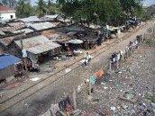
10 EXECUTIVE SUMMARY The railway in Cambodia consists of two lines, the Northern Line and the Southern line. The Northern Line, was built in the 1920s and extends for approximately 388 kilometres from Phnom Penh to Poipet, on the border with Thailand. The last 48 kilometres of the total length to the border with Thailand (the missing link) were destroyed during the war. The Southern line with a total length of approximately 264 kilometres was constructed in the late 1960s and links Phnom Penh with Sihanoukville, Cambodia s main seaport. The objectives of the Supplementary Study are to perform a feasibility study for the construction and rehabilitation of the railway branch lines of the Northern and the Southern Lines for enhancing the transport network, providing a better transport and linkage between cement factories, airports and a river port as follows; (1) Branch Line to Cement Factory at Touk Meas (2) Branch Line to Cement Factories at Kampot (3) Branch Line to Phnom Penh Port (GTW) (4) Rail Access to Phnom Penh Airport (5) Rail Access to Kampong Chhnang Airport (6) Rail Access to Sihanoukville Port s Inland Container Depot in Phnom Penh The Supplementary Report illustrates, firstly, the main issues relating to the initial engineering aspects, including technical survey of the condition of existing/planned alignments, hydrological and geotechnical investigations together with the technical specifications and bidding documents, which have been prepared for the main line rehabilitation works and applicable for the contracts for the construction or rehabilitation works. Secondly, based on the field investigations, the assessment of the general environmental profile, specific environmental conditions and detail environmental impacts together with the mitigation plans. Moreover, presently there are numbers of houses and dwelling cum small business units made of semipermanent materials are encroaching on the railway lines, especially on the branch line to GTW. When the railway tracks will be rehabilitated people utilizing the structures sitting closed to the railway alignment will be adversely affected. The census of land and properties and the socio-economic surveys had been conducted for determining the impact of the project then draw up the resettlement plan for the households that are negatively affected. Furthermore, in the line with the engineering design for construction/rehabilitation works, it comments on the proposed approach to an economic evaluation, together with the measurement of the distribution of project benefits, risk analysis and a plan for future monitoring of project benefit. TRACK STRUCTURE In general, track structure of a branch line shall be same as that of the main line to which the branch line is to be connected. However, when the same track material is not available or not recommendable, such as 30 kg rail in Northern Line, it is desirable to use a standardized track material. Rail There will be 3 types of rail material after the rehabilitation works completed, namely, 30 kg/m rails for Northern Line, 43kg/m rails for Southern Line, and BS 80A (39.68 kg/m) rails for the REHABILITATION OF RAILWAY IN CAMBODIA ADB T.A. NO REG Executive Summary Page i of xiii
11 Missing Link. From the point of track maintenance aspects, the use of a same track structure and materials is desirable in one line including its branch lines. Due to the existing poor condition it was recommended, in the Draft Final Report, to replace 30 kg/m rails with heavier rails in near future. Among the branch lines in this study, 3 lines are branching from Northern Line, namely, branch line to GTW at Phnom Penh, that to Phnom Penh Airport and that to Kampong Chhnang Airport. The branch line to GTW is to rehabilitate the existing track and the other two lines to airports are to construct new lines. Due to the limited budget for the rehabilitation work and the existing condition of the rail material, it was decided to re-use the existing rail material for the rehabilitation work. However, in the same reason for the main line track structure of Northern Line, early replacement of the rail is strongly recommended since the life of rail is nearly finished. For the two airport access lines, it is recommended to use 43kg/m rail due to a reason to be mentioned later. Same 43 kg/m rail shall be used for the branch lines to cement factories along Southern Line. Sleepers Sleepers will also be 3 types after the rehabilitation works, namely wooden, steel and PC sleepers. New PC sleepers will be used for the Missing Line and Southern Line, and the existing steel sleepers are to be used for Northern Line. According to site surveys, about 50% of the existing steel sleepers used in the branch line to GTW Phnom Penh shall be replaced because of heavy corrosion of steel materials. For this replacement, it is recommended to utilize the salvaged steel sleepers from Southern Line. According to the sleepers condition survey, about 5% of the existing sleepers in the Southern Line is steel and almost all of them are re-usable. This means the salvaged steel sleepers can be used for the construction of 13 km long track structure, and this quantity is enough to replace all the sleepers in this branch line. For the branch lines to cement factories located along Southern Line, PC sleepers are recommended in the same standard as the main line track structure. For the two airport access lines which located along Northern Line, PC sleepers are also recommended together with the usage of 43 kg/m rail. This is based on the idea that the up-grading of Northern Line in future to be utilized track materials of the existing Southern Line track materials. Since the forecasted passing tonnage of Southern Line will exceed 11 million ton/year, which requires 50 to 60 kg/m rails, around year By that time track structure of Southern Line shall be up-graded, and the salvaged track structure to be used in Northern Line. The forecasted passing tonnage of Northern Line is 3.8 million ton/year at year This means that 43 kg/m rail is still workable in that time. ROUTES The study comprises following 5 branch lines; 1) New branch line to cement factory at Touk Meas, 2) New branch line to cement factories at Kampot, 3) Rehabilitation of existing branch line to Phnom Penh Port (Green Trade Warehouse), 4) New access line to Phnom Penh Airport, and 5) New access line to Kampong Chhnang Airport. Based on the site condition, hydrological condition and construction cost with considering appropriate and efficient train operation service, the proposed location and alignment has been examined and selected in this study. Location of each branch lines and general information of alignment are shown in the figures below. REHABILITATION OF RAILWAY IN CAMBODIA ADB T.A. NO REG Executive Summary Page ii of xiii
12 1) Branch line to cement factory at Touk Meas: Tram Sasar St. PK Access Road Cement Fact ory (KC Factory) Proposed Rout e Route Length: 5.6 km Min. Radius Curve: 300m Ave. Gradient: 3.2 Touk Meas St. PK ) Branch line to cement factories at Kampot New Cement Factory (TBR Factory) National Road No.3 Existing Cement Factory (AZ Factory) Section 1 Route Length: 11.6 km Min. Radius Curve: 300m Ave. Gradient: 1.2 Section 2 Route Length: 12.7 km Min. Radius Curve: 600m Ave. Gradient: 2.2 Kampot Station PK REHABILITATION OF RAILWAY IN CAMBODIA ADB T.A. NO REG Executive Summary Page iii of xiii
13 3) Branch line to Phnom Penh Port (GTW) GTW Yard Green Trade Warehouse WFP CALTEX PK ICD PK PK Sokimex Branch Line Route Length: 6.7 km Min. Radius Curve: 300m Ave. Gradient: Level PK Phnom Penh Station PK REHABILITATION OF RAILWAY IN CAMBODIA ADB T.A. NO REG Executive Summary Page iv of xiii


14 4) Airport access line to Phnom Penh Airport Airport Access Line Pedestrian Deck Route Length: 4.5 km Min. Radius Curve: 300m Ave. Gradient: Level National Road No.3 5) Airport access line to Kampong Chhnang Airport Proposed Route Route Length: 24.7 km Min. Radius Curve: 1000m Ave. Gradient: 6.0 REHABILITATION OF RAILWAY IN CAMBODIA ADB T.A. NO REG Executive Summary Page v of xiii
15 BRIDGES AND CULVERTS New bridges and culverts in the branch lines will be designed under the conditions of single line and the maximum axle load of 20 tonnes. Based on the site survey and an analysis of aerial photos, three different bridge lengths (10m, 20m and 30m) will be necessary for the branch lines. In addition to these bridges and culverts, two types of box culverts of 3.0m in width and 2.0m in height and of 3.0m in width and 2.5m in height, and pipe culverts of φ 1 m will also be installed. In the Northern Line and the Southern Line of RRC there are steel bridges and concrete bridges. From the economical view point of construction, concrete bridges will be recommended, because steel materials have to be imported and the unit cost of steel bridges is relatively higher than that of concrete bridges. For bridges with length of 10m and 20m, monolithic concrete bridge or reinforced concrete bridge of T-type girder is recommended. For a bridge with length of 30m prestressed concrete girder is recommendable although monolithic concrete bridge can also be adopted. However, depending upon the locations of bridges, the burden on abutments can be reduced and easier construction is enabled in some cases by adopting the built-up girder or trough girder type bridges, or steel bridges with steel deck girders and so forth. The existing box and pipe culverts along the railway lines mostly have a double function. They act as the drainage system to prevent water from flooding the railway embankment and as well as irrigation system to the rice fields. Based on the actual data of spacing of pipe culverts, pipe culverts of branch lines shall be installed at 500m intervals. The diameter of pipe culvert will be 1m. Branch Line to Cement Factory at Touk Meas The following table summarizes the civil structures needed for this branch line. Type Option 1 Option 2 Option 3 Length of Branch Line 5.2 km 7.2 km 5.8 km Bridge L=20 m: 1 L=10 m: 3 L=30 m: 2 L=10 m: 1 L=20 m: 1 Box Culvert 3 m x 2 m: 1 3 m x 2m: 1 No 3 m x 2.5m: 1 Pipe Culvert (φ 1 m) Branch Line to Cement Factories at Kampot The following table summarizes the civil structures needed for this branch line. Type Section 1 Section 2 Length of Section L=11.6 km L=12.9 km Bridge L=10 m: 1 No Box Culvert 3 m x 2.5 m: 6 3 m x 2 m: 2 Pipe Culvert (φ 1 m) REHABILITATION OF RAILWAY IN CAMBODIA ADB T.A. NO REG Executive Summary Page vi of xiii
16 Branch Line to Phnom Penh Port (GTW) The following table summarizes the civil structures needed for this branch line. Type Section 1 Section 2 Section 3 Section 4 Section GTW ICD SOKIMEX Bridge No No Pier L=166 m* No Box Culvert No No No 3 m x 2.5 m: 1 Pipe Culvert (φ 1 m) No 1 No No * The pier can be used as a base of a conveyor for cement transportation with no or minor repair. Airport Access to Phnom Penh Airport The following table summarizes the civil structures needed for this branch line. Type Option 1 Option 2 Length L=4.4 km L=4.8 km Bridge No No Box Culvert No No Pipe Culvert (φ 1 m) Airport Access to Kampong Chhnang Airport The following table summarizes the civil structures needed for this branch line. Type Option 3 Length of Branch Line L=24.7 km Bridge L=10 m: 4 Box Culvert 3 m x 2.5 m: 4 Pipe Culvert (φ 1 m) 50 HYDROLOGICAL CONDITIONS After many years of neglect and with recent economic development perspective, railway transportation in Cambodia has lastly received comparative attention from the government and the publics at large. Full rehabilitation of the whole existing railway lines is being planned. In the planning, in addition to existing lines, new connecting lines to the most important key economic zones of the country are also included as supplement to the rehabilitation plan namely: the connection of the southern line with the two new cement factories, the Kampot Cement factory in Touk Meas and the Thai Boon Roong Cement factory in the northeast of Kampot; the connection of the northern line with the Kampong Chhnang and Phnom Penh airport and the connection with Phnom Penh Port on the Tonle Sap River were also included. The connection lines to the two cement factories runs through part of the flood prone areas of the Touk Meas and the Kamchay river catchments needs due consideration on the impacts of the part of the new lines on local drainage conditions important for local subsistence rice cultivation and other development infrastructure. In Phnom Penh, local city development plan guiding comprehensive REHABILITATION OF RAILWAY IN CAMBODIA ADB T.A. NO REG Executive Summary Page vii of xiii
17 drainage system analysis has not been developed and need more data on future city comprehensive development plan. The connection line with the Kampong Chhnang airport was planned outside of the flood prone areas, however due consideration is required related to coordination with water resources development and management in the region. GEOTECHNICAL CONDITIONS All project areas for five branch lines are lying on soft ground areas of alluvial plain. Hence, it is recommended that the embankment height of all branch lines shall be limited less than 2m to protect slope failure and reduce consolidation settlement. Regarding depth of the bearing strata for substructures of bridges, it is expected to have ranges of 10m - 25m in depth. It is recommended that geotechnical examinations such as boring, SPT, and various laboratory tests shall be conducted to decide the countermeasure work more accurately in detail design stage. ENVIRONMENTAL ISSUES The environmental issues that prepared for fulfilling the requirement of supplementary report of GMS Rehabilitation of the Railway in Cambodia, and will be use as an environmental report that presented the social and environmental condition and described the expectation impact on the social and environmental resources which will be happened from design, construction and operation of five different branch line namely (1) Branch Line to Cement Factory at Touk Meras (KC factory), (2) Branch Line to Cement Factories at Kampot and Dang Tung (AZ, Lafarge, and TBR factory), (3) Branch Line to Phnom Penh Port (GTW), (4) Airport Access to Phnom Penh Airport, and (5) Airport Access to Kampong Chhnang Airport. Field investigation on the environmental and social resources in/around alignment of each proposed branch line was conducted by local environmental specialist together with hydrology and resettlement specialist. Team discussion with all specialists expatriate and local whom ongoing prepare the project GMS Rehabilitation of the Railway in Cambodia is regularly done. Screening the positive and negative impact on the social and environmental resources caused by the project activities had described at point c, d and e in each subtitle (3.2.4; 3.3.4; 3.4.4; 3.5.4; and 3.6.4) of the report contents, and mitigation measure had included following the significant impact in each paragraph of the subtitle social an environmental consideration and recommendations. The four proposed branch lines (Branch Line to Cement Factory at Touk Meras, Branch Line to Cement Factories at Kampot, Branch Line to Phnom Penh Port, and Airport Access to Kampong Chhnang Airport) have a good feasibility to include in project implementation, based on recently environmental screening on social and environmental impacts that were described in environmental sections in the Report. Brief positive impacts caused by four proposed branch lines are: - bring to life the existing branch lines and new branch lines for providing transportation means for cement products and bulk goods; - provide comfort and safe transportation with effective costs comparing with other transportation means; - reduce traffic and road accident on auto-routes in the country and road maintenance costs; and - provide employment opportunity to local communities in construction and operation phases; While the proposed airport access to Phnom Penh International Airport is not feasible to include in the project implementation, because of negative social and environmental impacts and there is not any notably positive impacts due to project design, construction and operation. However justification on some of environmental issues for each branch line may be needed in the detailed engineering design and construction period. REHABILITATION OF RAILWAY IN CAMBODIA ADB T.A. NO REG Executive Summary Page viii of xiii
18 RESETTLEMENT AND SOCIO-ECONOMIC ISSUES In general, the proposed railway lines have less resettlement impacts on structure, except for Phnom Penh Port branch line. However, it has significant impact on land acquisition. Assessment of impoverishment risks range from low to medium except for Phnom Penh Port branch where the joblessness and homeless are potentially high. In rural village the socio-economic profile of the affected households are similar. The proposed branch lines will affect on a range of land, structure and crops and tress. Touk Meas branch line is envisaged to have affected about 50 households including the minor affect. About 20 households will be affected their [other] structure and crops and trees. The estimate resettlement cost for Touk Meas branch line is 67, Kampot branch line will affect approximately 558 households, including the minor affect. About 130 households will be affected their [other] structure, basically at the Section 1 and crops and trees, at Section 2. The estimated resettlement cost for Kampot branch line is 159, Phnom Penh Port is estimated having affected about 800 households, including the minor affect. About 450 households will be affected their main structures. The estimated resettlement cost is 999, Phnom Penh Airport branch will affect approximately 100 households, including the minor affect. About 25 households will be affected their [other] structure and crops and trees. The estimated resettlement cost for Kampot branch line is 2,341, Kampong Chhnang Airport branch is estimated having affected about 450 households, including the minor affect. About 150 households will be affected their structure. The estimated resettlement cost is USD 271, PROJECT COST ESTIMATION The summary of the estimated project costs for each branch line are shown in a table below. To Cement Factory at Touk Meas To Cement Factory at Kampot (Section 1) To Phnom Penh Port (Unit: Million US Dollar) To Phnom Penh Airport To Kampong Chhnang Airport 1. Construction Cost 2. Engineering Service Cost 3. Administrative Cost 4. Contingencies Sub-total ( ) Land Acquisition & Compensation Cost Sub-total ( ) 6. Price Escalation Total REHABILITATION OF RAILWAY IN CAMBODIA ADB T.A. NO REG Executive Summary Page ix of xiii
19 ECONOMIC AND FINANCIAL ANALYSIS Investment in the construction or rehabilitation of three freight only branch-lines may be expected to generate robust economic benefits as a result of their capacity to remove or at least to avoid additional heavy vehicular traffic on the country s primary road system. Additional information which has recently become available on plans for the construction of new cement plants in Kampot Province has revealed that the potential for rail haulage of cement may have been understated to a substantial extent in the main traffic demand forecast which formed the basis of the evaluation of the mainline rehabilitation project. Current plans for domestic cement production are likely to generate demand for the transportation by rail of more than 2 million tonnes per year of cement by 2010, rising to 4.5 million tonnes by These volumes are some 75 per cent in excess of those in the earlier forecast and would be supplemented by the transport of about 700,000 tonnes per year of input materials for cement production, comprising coal, gupsum, heavy fuel oil and biomass. Realization of the revised traffic forecast will depend on the provision of branch-line connections between two new plants in Kampot Province (those of the Kampot Cement and Lafarge Cement companies) and the Southern mainline. With these branch-line connections, rehabilitation of the Southern Line is likely to yield an EIRR (Economic Internal Rate of Return) of nearly 30 per cent in the base traffic case. Without them, the EIRR would fall to only 7 per cent, which is well below the ADB cut-off rate for loan funding of 12 per cent. An incremental analysis of the net economic benefits likely to be generated by construction of the cement branch-lines shows that both projects have the potential to yield EIRR s in excess of 40 per cent. Rehabilitation of the Phnom Penh Port Access Line will restore a link between the railway and inland waterway transfer facilities on the Tonle Sap River. Since nearly 30 per cent of the production of one cement company will be destined for consumption centres in provinces to the north of Phnom Penh, restoration of this link will also be critical for the achievement of the cement traffic forecast. The link also has the potential to generate about 900,000 tonnes of petroleum traffic per year, comprising the full range of refined petroleum, not just diesel fuel as at present. An incremental analysis of investment in the rehabilitation of this link has revealed a potential EIRR of 36 per cent in the base traffic case. Analysis of the potential financial returns available from all three freight branch-line projects suggests that these returns will be sufficiently attractive to encourage investment participation by the private sector. On the other hand, the analysis of two passenger branch-line projects (Phnom Penh Station to Phnom Penh International Airport and Phnom Penh Station to Kampong Chhnang Airport) has shown that neither is likely to generate sufficient passenger revenue to be able to cover capital and operating costs. The lack of a direct rail connection between the airports and Phnom Penh City hotels will restrict the attractiveness of rail services to tourists and in the case of the Kampong Chhnang Airport line, a rail shuttle service will not be cost competitive with bus transport. SIGNALLING AND TELECOMMUNICATION In general, the minimum extent to which the existing facilities should be upgraded depends on the increase in frequency of train operations, train speed, necessary effective length at stations and so forth, according to basic train operation plan proposed in the report, based on traffic demand forecast. In order to realize a degree of better safety, it is indispensable to introducing essential railway equipments with cost effectiveness shown in below, not only avoiding the collisions between trains on REHABILITATION OF RAILWAY IN CAMBODIA ADB T.A. NO REG Executive Summary Page x of xiii
20 the line and between a train and passers-by at the level crossing, but also reducing operation time through releasing the work on handling of mechanic switches. (1) Restricted Automatic Block System (2) Railway Crossing Warning Facility (3) Spring Switch Machine Moreover, if installed the minimum required facilities described in above, as a result, it should be emphasized that a train dispatcher in the operation center will be able to monitor train movements and manage the train operation. In the future, it is recommended that the improvement and upgrading plan should be accomplished with increase in frequency and in speed of train operation in the followings. (1) Interlocking equipment (2) Centralized Traffic Control system (3) Reinforcement of radio system on the operation for Block, Dispatch and Maintenance with full and reliable coverage (4) Railway telephone network with extensions in offices, stations, rolling stock workshop, maintenance depots ALTERNATIVE ALIGNMENT AT CAMBODIA-THAI BORDER It was suggested by NEDA during the meetings among MPWT, ADB, NADA, RRC, Consultants, and other Cambodian Government authorities in June 2006 that, in order to avoid environmental impacts to the society along the railway line, Thai Government may consider the diversion of the railway alignment at the border section. The study was conducted to find potential detour alignments which can avoid built up areas in both Cambodia and Thailand. Since there is no railway structure remained in Cambodia side, and the existing railway structure is under operation up to Aranyaprathet station in Thai side, re-alignment study was made in the section of 8km, i.e. 4 km both side of the border which does not cover Aranyaprathet station but covers Poipet station. There are three alternative routes were suggested as follows: REHABILITATION OF RAILWAY IN CAMBODIA ADB T.A. NO REG Executive Summary Page xi of xiii
21 Thai - Cambodia Border Option- 1 Aranyaprathet Poipet NR- 5 Buil- up Area NR- 33 Option- 2A Option- 2B Option 1 (Diversion to North) New alignment is running to northeast at 4 km after Aranyaprathet station and 1.8 km from the border. It is running 2.2 km towards northeast then turn to southeast direction towards the border 400 m ahead. After crossing the border, the alignment is running straight to avoid crossing a golf course and turns to further south direction approximately 4 km before crossing NR5 and reaching the original alignment in Cambodia. Option 2A (Diversion to South Short) New alignment is going southwards at 2.4 km after Aranyaprathet station and 3.4 km from the border and cross NR-33 (Thialand) at 2.8 km. It is running 2.2 km to the south then turn to southeast direction running about 1.6 km. Next, it turns to east direction and is running about 1.2 km to cross the border river and is further running 800 m in same direction before reaching the original alignment in Cambodia. Cross-border station is recommended to construct in Cambodia side because of the easier access to the new station. Option 2B (Diversion to South Long) The first half of this alignment is same as in Option 2A. The New alignment is running further southwards of approximately 3.4 km then turns to northeast direction in about 1.3 km up to the border river and further running in same direction in about 600 m before reaching the original alignment in Cambodia. Cross-border station is recommended to construct in Cambodia side for both Options 2A and 2B for the easier access to the new station. RAIL ACCESS TO SIHANOUKVILLE PORT S INLAND CONTAINER DEPOT IN PHNOM PENH The study was requested by ADTA consultant which intends to make ROC develop this area as freight terminal. The Inland Container Depot is located at the 14km southwest from the center of Phnom Penh city, near a crossing point of NR4 and Southern Line. The ICD has a possibility to be used as the main freight terminal in Phnom Penh because the ICD has an extensive undeveloped land around the existing developed ICD, good location extremely close to Southern Line and NR4, and good access from/to the center of Phnom Penh by NR4. REHABILITATION OF RAILWAY IN CAMBODIA ADB T.A. NO REG Executive Summary Page xii of xiii
22 Schematic drawing in and around the ICD is shown in the figure below. 650m 180m 300m Undeveloped Land owned by ICD (Paddy Field) 230m Developed ICD Area (Embankment Height: App 2m) Pond 90m 230m 25m 660m within ROW of RRC (Paddy Field & Drainage Ditch) 30m to Phnom Penh Southern Line (PK to PK15+160, Embankment Height: App. 2m) to Sihanoukville The related area is divided into three areas, i) Developed ICD Area, ii) Undeveloped Land owned by ICD, and iii) within ROW of RRC. Based on the request from ADTA consultant, the following alignment in the ICD was planned. Legend : Track Alignment : Culvert note: 2m height embankment to be required for track aligement except on the developed ICD area. Developed ICD Pond Undeveloped Land owned by ICD (to do land developed) Culvert to Phnom Penh Southern Line to Sihanoukville There are total six lanes in the ICD. Short car unit freight trains use the above three lanes, and middle or long car unit freight train use the lower three lanes in the figure. The estimated project cost is approximately USD 2.48 million. CONCLUSIONS The study proved that the rehabilitation and construction of the branch lines to Cement factories at Touk Meas and Kampot, and the access to Phnom Penh Port (GTW) are technically, economically and environmentally viable with an adequate economic internal rate of return. Therefore, it is recommended that the projects should be implemented as scheduled. However, due to the low demand forecast and high project cost, it will be very difficult to make the project viable for the construction of the spur lines access to Phnom Penh and Kampong Chhnang Airports. REHABILITATION OF RAILWAY IN CAMBODIA ADB T.A. NO REG Executive Summary Page xiii of xiii
23 REHABILITATION OF RAILWAY IN CAMBODIA ADB T.A. NO REG FINAL REPORT VOLUME 2 THE STUDY FOR BRANCH LINES 1. INTRODUCTION 1.1 PURPOSE OF THE STUDY FOR BRANCH LINES The objectives of the Study for Branch Lines are to perform a feasibility study for the construction and rehabilitation of the railway branch lines of the Northern and the Southern Lines for enhancing the transport network, providing a better transport and linkage between cement factories, airports and a river port as follows; (1) Branch Line to Cement Factory at Touk Meas (2) Branch Line to Cement Factories at Kampot (3) Branch Line to Phnom Penh Port (GTW) (4) Airport Access at Phnom Penh (5) Airport Access at Kampong Chhnang The main purpose of the Report for the study for the Branch Lines is to portray the findings drawn from the review of the previous studies, preliminary tasks and investigations including: - preliminary engineering design of branch lines; - an assessment of the condition of existing track up to Green Trade Warehouse (GTW); - preliminary environmental survey; - preliminary resettlement and socio-economic survey; - economic and financial analysis; and - implementation schedule. The Report for the study for the Branch Lines illustrates, firstly, the main issues relating to the initial engineering aspects, including technical survey of the condition of existing/planned alignments, hydrological and geotechnical investigations together with the technical specifications and bidding documents, which have been prepared for the main line rehabilitation works and applicable for the contracts for the construction or rehabilitation works. Secondly, based on the field investigations, the assessment of the general environmental profile, specific environmental conditions and detail environmental impacts together with the mitigation plans. Moreover, presently there are numbers of houses and dwelling cum small business units made of semipermanent materials are encroaching on the railway lines, especially on the branch line to GTW. When the railway tracks will be rehabilitated people utilizing the structures sitting closed to the railway alignment will be adversely affected. The census of land and properties and the socio-economic surveys had been conducted for determining the impact of the project then draw up the resettlement plan for the households that are negatively affected. Furthermore, in the line with the engineering design for construction/rehabilitation works, it comments on the proposed approach to an economic evaluation, together with the measurement of the distribution of project benefits, risk analysis and a plan for future monitoring of project benefits. REHABILITATION OF RAILWAY IN CAMBODIA Chapter 1 ADB T.A. NO REG Page 1 of 2
24 Missing Link Nort hern Line Kampong Chhnang Airport Access Phnom Penh Port Branch Line Branch Line to Cement Fac t or y at Touk Meas Branch Line to Cement Fact or ies at Kampot Phnom Penh Airport Access Sout hern Line Figure 1.1 Location Map REHABILITATION OF RAILWAY IN CAMBODIA Chapter 1 ADB T.A. NO REG Page 2 of 2
25 2. REVIEW OF THE PREVIOUS STUDIES 2.1 REVIEW OF INCEPTION AND DRAFT FINAL REPORTS Inception Report (1) Branch Lines to Cement Factories It was confirmed that the same standards of the main line track structure shall be applied to the branch lines to cement factories. At the time of the Inception Report, the construction of Thai Boon Roong cement factory which is under construction at 22km north of Kampot station, was not informed and, therefore, not mentioned in the report. (2) Branch Line to Phnom Penh Airport The following options of Airport approach were mentioned in the Inception Report; a) Elevated railway crossing over NR-3 b) At-grade railway and flyover of NR-3 c) Pedestrian deck connection Due to the limited space in front of the Airport Terminal Building, and comparison of the construction costs, Option c) above was recommended. The branching point from the main line was not studied in the report. (3) Branch Line to Kampong Chhnang Airport No technical study was made in the Inception Report. Only the necessity of higher speed train operation is pointed out to make the passenger train more attractive Draft Final Report (1) Branch Line to Phnom Penh Port Facilities Due to the same track structure, it was considered that the same rehabilitation method as that of Northern Line could be applied for this branch line. The section for the rehabilitation was considered up to the Inland Container Depot which was under construction. The importance of rehabilitation up to Green Trade Warehouse (GTW) which has pier structure at Tongle Sab River was not recognised at the stage. (2) Branch Line to Cement Factory at Touk Meas Two options of the branch line were planned. Option 1 is branching from the existing Touk Meas station (PK ) and running along the existing village road towards the factory. Option 2 is REHABILITATION OF RAILWAY IN CAMBODIA Chapter 2 ADB T.A. NO REG Page 1 of 4

26 branching from a new station location (around PK ) and running along the newly constructed access road to the factory. It was planned to take aerial photos to select the optimum alignment. Access Road Option 2: connect from New Station Option 1: connect from Touk Meas Stn. Fig (2) Branch Line to Cement Factory at Touk Meas (3) Branch Line to Cement Factories at Kampot It was informed that Thai Boon Roong Cement is constructing a cement factory at 22 km northeast of Kampot station. Since there is a trace of branch line structure up to 11 km, where old and product suspending cement factory is locating, the branch line is planned to extend the old alignment. After the Draft Final Report was issued, new information was given that Lafarge, French company, is also planning to build a cement factory nearby the old cement factory. Then, the study of this branch line was divided into 2 sections; namely, Section 1 from Kampot station to old cement factory (or Lafarge factory), and Section 2 from the end of Section 1 to Thai Boon Roong cement factory. REHABILITATION OF RAILWAY IN CAMBODIA Chapter 2 ADB T.A. NO REG Page 2 of 4
27 New Cement Factory National Road No. 3 New Track to Cement Factory Kampot Station Abandond Alignment from Kampot Stn. Fig (3) Branch Line to Cement Factory at Kampot (4) Phnom Penh Airport Rail Access There are 2 potential branching stations near the airport. The nearest station is Pochentong, locating about 1.8 km northeast of the airport terminal building. The next station is Fork station, locating 2.2 km northwest of the same. According to site surveys, it was found that the area between Pochentong station and the terminal building of Phnom Penh airport is densely built-up and there is no room to construct a railway track without land acquisition and resettlement activities. On the contrary to Pochentong route, there are continuous open spaces are found by the satellite photo survey in the area between Fork station and the airport terminal building. Therefore, it was decided to prepare the preliminary design of this branch line from Fork station. REHABILITATION OF RAILWAY IN CAMBODIA Chapter 2 ADB T.A. NO REG Page 3 of 4
28 New Line Fork Station Pochentong Station Phnom Penh Station NR- 3 Airport Station Built- up Area Phnom Pen Airport Terminal Fig (4) Phnom Penh Airport Rail Access (5) Kampong Chhnang Airport Rail Access The RRC planned alignment connecting from Krang Skea station (PK ) was not recommended because of the poor soil condition, requirements of bridge structure and high embankment, New alignment study was recommended connecting form Romeas station (PK ) to the airport terminal. REHABILITATION OF RAILWAY IN CAMBODIA Chapter 2 ADB T.A. NO REG Page 4 of 4
29 3. PRELIMINARY ENGINEERING DESIGN 3.1 GENERAL Geometric Design Table and Table show geometric design criteria of the Northern Line and the Southern Line respectively. Main features of these design criteria are very similar. The major differences between the two lines are maximum gradient and axle load. In the Northern Line the maximum gradient is at maximum of 6.5 %o and axle load is 15 tonnes, while the maximum gradient is 7 %o and axle load is 20 tonnes in the Southern Line. Table Geometric Design Criteria of the Northern Line 1. Track gauge 1,000 mm 2. Minimum radius Main track 300 m (mostly 500 m) Side track 150 m 3. Maximum gradient 6.5 %o 4. Cant Cmax = 100 mm General cant = 6V 2 / R ( h = ( S * V 2 ) / ( g * R )) C : mm, V: km/h, R: m 5. Length of transition curve L > 0.6C L > 0.008CV 6. Gauge widening s = 20 mm R < 200 m s = 15 mm 200 m < R < 250 m s = 10 mm 250 m < R < 300 m s = 5 mm 300 m < R < 500 m 7. Distance between track Main track 5.0 m centers Side track 4.2 m 8. Axle load 15 tons 9. Width of roadbed formation L = 5.0 m Source: RRC Table Geometric Design Criteria of the Southern Line 1. Track gauge 1,000 mm 2. Minimum radius Main track 300 m (mostly 500 m) Side track 150 m 3. Maximum gradient 7.0 %o 4. Cant Cmax = 100 mm General cant = 6V 2 / R ( h = ( S * V 2 ) / ( g * R )) C : mm, V : km/h, R : m 5. Length of transitional curve L > 0.6C L > 0.008CV 6. Gauge widening s = 20 mm R < 200 m s = 15 mm 200 m < R < 250 m s = 10 mm 250 m < R < 300 m s = 5 mm 300 m < R < 500 m 7. Distance between track centers Main track: 5.0 m Side track: 4.2 m 8. Axle load 20 tons 9. Width of roadbed formation L = 5.0 m Source: RRC REHABILITATION OF RAILWAY IN CAMBODIA Chapter 3 ADB T.A. NO REG Page 1 of 115
30 In accordance with these existing criteria, the basic geometric design criteria for the branch lines is decided as shown in the Table below. Table Geometric Design Criteria for Branch Lines 1. Track gauge 1,000 mm 2. Minimum radius Main track 300 m Side track 150 m 3. Maximum gradient 6.5 %o 4. Cant Cmax = 100 mm General cant = 6V 2 / R ( h = ( S * V 2 ) / ( g * R )) C : mm, V: km/h, R: m 5. Distance between track Main track 5.0 m centers Side track 4.2 m 6. Axle load 20 tons 7. Width of roadbed formation L = 5.0 m REHABILITATION OF RAILWAY IN CAMBODIA Chapter 3 ADB T.A. NO REG Page 2 of 115
31 3.1.2 Track Structure In general, track structure of a branch line shall be same as that of the main line to which the branch line is to be connected. However, when the same track material is not available or not recommendable, such as 30 kg rail in Northern Line, it is desirable to use a standardized track material. The standard track structure and materials will be described hereinafter and in Section 7, Conclusions and Recommendations. (1) Rail There will be 3 types of rail material after the rehabilitation works completed, namely, 30 kg/m rails for Northern Line, 43kg/m rails for Southern Line, and BS 80A (39.68 kg/m) rails for the Missing Link. From the point of track maintenance aspects, the use of a same track structure and materials is desirable in one line including its branch lines. Due to the existing poor condition it was recommended, in the Draft Final Report, to replace 30 kg/m rails with heavier rails in near future. Among the branch lines in this study, 3 lines are branching from Northern Line, namely, branch line to GTW at Phnom Penh, that to Phnom Penh Airport and that to Kampong Chhnang Airport. The branch line to GTW is to rehabilitate the existing track and the other two lines to airports are to construct new lines. Due to the limited budget for the rehabilitation work and the existing condition of the rail material, it was decided to re-use the existing rail material for the rehabilitation work. However, in the same reason for the main line track structure of Northern Line, early replacement of the rail is strongly recommended since the life of rail is nearly finished. For the two airport access lines, it is recommended to use 43kg/m rail due to a reason to be mentioned later. Same 43 kg/m rail shall be used for the branch lines to cement factories along Southern Line. (2) Sleepers Sleepers will also be 3 types after the rehabilitation works, namely wooden, steel and PC sleepers. New PC sleepers will be used for the Missing Line and Southern Line, and the existing steel sleepers are to be used for Northern Line. According to site surveys, about 70% of the existing steel sleepers used in the branch line to GTW Phnom Penh shall be replaced because of heavy corrosion of steel materials. For this replacement, it is recommended to utilize the salvaged steel sleepers from Southern Line. According to the sleepers condition survey, about 5% of the existing sleepers in the Southern Line is steel and almost all of them are re-usable. This means the salvaged steel sleepers can be used for the construction of 13 km long track structure, and this quantity is enough to replace all the sleepers in this branch line. For the branch lines to cement factories located along Southern Line, PC sleepers are recommended in the same standard as the main line track structure. For the two airport access lines which located along Northern Line, PC sleepers are also recommended together with the usage of 43 kg/m rail. This is based on the idea that the up-grading of Northern Line in future to be utilized track materials of the existing Southern Line track materials. Since the forecasted passing tonnage of Southern Line will exceed 11 million ton/year, which requires 50 to 60 kg/m rails, around year By that time track structure of Southern Line shall be up-graded, and the salvaged track structure to be used in Northern Line. The forecasted passing tonnage of Northern Line is 3.8 million ton/year at year This means that 43 kg/m rail is still workable in that time. REHABILITATION OF RAILWAY IN CAMBODIA Chapter 3 ADB T.A. NO REG Page 3 of 115
32 3.1.3 Bridges and Culverts (1) Design Issues a) Design Axle Load 1) Axle load The design axle load is 15 tonnes in the Northern Line and 20 tonnes in the Southern Line respectively. The present railway infrastructures in the Northern Line and the Southern Line were designed for these axle loads. However, in the rehabilitation of railway bridges and culverts in the Northern Line an axle load of 20 tonnes will be applied for the preparation of the future improvement. Therefore, in designing structures such as bridges and culverts of the branch lines an axle load of 20 tonnes shall be applied. 2) Axle load diagram Figure shows the axle load diagram for the design of railway infrastructures of RRC. The bridges and culverts of the branch lines shall be designed to carry the loads shown in Figure Figure Axle Load (Loading Diagram) (Unit: ton) Source: RRC b) Bridge Design Standard The Cambodia Bridge Design Standard (CAM PW ) shall be used for the design of all railway bridges in the Kingdom of Cambodia. The Cambodian Bridge Design Standard consists of the following complementary documents. - CAM PW Australian Bridge Design Code 1996 (the Base Document) and associated Commentary; - CAM PW this document (the Amendments) which contains amendments and additions to the Base document; and - The Commentary on the Cambodian Bridge Design Standard which contains amendments and additions to the Commentary on the Base Document. REHABILITATION OF RAILWAY IN CAMBODIA Chapter 3 ADB T.A. NO REG Page 4 of 115
33 These documents shall be considered together. In the case of a conflict between the provisions of the Base Document and the provisions of the Amendments, the Amendments shall override the Base Document. From time to time the Base Document may be changed by the Australian Authorities. Any such change shall be automatically incorporated into the Cambodian Bridge Design Standard unless it conflicts with a provision of the Amendments. For the purpose of regulating and interpreting the provisions of this Standard, the AUTHORITY shall be the Cambodian Ministry of Public Works and Transport. c) Construction gauge and rolling stock gauge The railway structure shall not be build within the construction gauge. Figure shows the construction gauge and rolling stock gauge of RRC. Figure Construction gauge and rolling stock gauge. Source: RRC REHABILITATION OF RAILWAY IN CAMBODIA Chapter 3 ADB T.A. NO REG Page 5 of 115
34 (2) Bridge Type a) Design Condition and Bridge Type 1) Design Condition and Bridge Length Bridges in the branch lines are designed under the following conditions. - Single line - Maximum axle load is 20 tonnes - Not electrified line Based on the site survey and an analysis of aerial photos, three different bridge lengths (10m, 20m and 30m) will be necessary for the branch lines. 2) Bridge Type In the Northern Line and the Southern Line of RRC there are steel bridges and concrete bridges. From the economical view point of construction, concrete bridges will be recommended, because steel materials have to be imported and the unit cost of steel bridges is relatively higher than that of concrete bridges. Especially in the case where the distance between the bottom of the beam and the water level is 4 to 5m, reinforced concrete bridge construction is less expensive than steel bridge construction, because concrete can be cast in place with temporary supports for concrete form assembled in place. In this case, however, quality control of concrete and supervision of construction at the site are important. In the case where the bridge length is about 20m, the one-span structure is recommendable in terms of construction cost, because the two-span structure requires pier construction. For bridges with a length of about 20m or less, it is allowable to adopt the monolithic concrete structure, rigid-frame type concrete structure, or reinforced concrete structure. However, the prestressed concrete structure is desirable for 30 m bridges. Table shows an outline of the scope of concrete bridge length together with the corresponding bridge structure types. Table Selection of Concrete Bridge Type Bridge Length Structure Type 10 to 20m Monolithic concrete bridge, or rigid-frame type concrete bridge (A1-Type, A2-Type, B1-Type and B2-Type) Reinforced concrete T-type girder 15 to 30m Monolithic concrete bridge, or rigid-frame type concrete bridge (A2-Type and B2-Type) Prestressed concrete T-type girder For girders with a length of about 20m, it is recommendable to adopt the double main girder structure consisting of two T-shaped girders produced at a factory are carried to the construction site, where they are transversely pressed and the concrete roadbed is cast. For PC girders, however, production supervision at the factory is especially important. Depending upon the locations of bridges, the burden on abutments can be reduced and easier construction is enabled in some cases by adopting the built-up girder or trough girder type bridges, or steel bridges with steel deck girders and so forth. REHABILITATION OF RAILWAY IN CAMBODIA Chapter 3 ADB T.A. NO REG Page 6 of 115
35 In any case, it is necessary to conduct detailed investigations in the future to decide the bridge structure types to be adopted. b) Concrete Bridges Concrete bridges recommended to be adopted in the branch lines are shown in the following drawings. In this section bridges with lengths of 10m and 20m are shown. As for a bridge with a length of 30m, please refer to X Bridges and Culverts. 1) Bridge Length of 10m:A1-Type (Figure ) A1-Type is single span concrete bridge with a bridge length of about 10m. For reference, A2- Type is multiple simple span concrete bridge, which is used for longer bridge length of about 20m. Figure A1-Type Concrete Bridge REHABILITATION OF RAILWAY IN CAMBODIA Chapter 3 ADB T.A. NO REG Page 7 of 115
36 2) Bridge Length of 10m: B1-Type (Figure ) B-Type is 3-span monolithic concrete bridge, or rigid-frame type concrete bridge. B-Type is also classified into two types, B1, pier height of which is less than 3.25m, and B2, whose pier height is greater than 3.25m. In this case, B1-Type can be used for bridges with a length of about 10m. Figure B1-Type Concrete Bridge 3) Bridge Length of 20m: T-shaped RC beam (Figure ) For girders with a length of about 20m, it is recommendable to adopt the double main girder of reinforced concrete structure consisting of two T-shaped girders as shown in Figure REHABILITATION OF RAILWAY IN CAMBODIA Chapter 3 ADB T.A. NO REG Page 8 of 115
37 Figure B1-Type Concrete Bridge c) Steel Bridges In this study concrete bridges are planned to be adopted in the branch lines. However, the following shows types of steel bridges with length of 10m and 20m for reference. 1) Bridge Length of 10m:J1-Type (Figure ) J-Type is a built-up steel girder, or trough girder type bridge with the standard span length of 8.35m (J1) and 11.55m (J2). This type of steel bridge can be used for the bridge with a length of 10m. REHABILITATION OF RAILWAY IN CAMBODIA Chapter 3 ADB T.A. NO REG Page 9 of 115
38 Figure J1-Type Steel Bridge 2) Bridge Length of 20m:A1-Type (Figure ) Figure shows steel deck girders with a length of 20m and Table shows main dimensions of this girder. Table Dimension of Steel Deck Girder Item Dimension Span length 20,000mm Bridge length 20,300mm Web height 1,800mm Distance between base of rail and shoe 2,200mm Distance between base of rail and the lower part of girder 2,100mm Total weight of girders about 23 tonnes REHABILITATION OF RAILWAY IN CAMBODIA Chapter 3 ADB T.A. NO REG Page 10 of 115
39 As described above, this type of bridge has the following advantage; - Reduction of the burden on abutments - Easy erection Therefore, in some cases this type of bridge can be recommended depending upon the locations of bridges. Anyway, it is necessary to carry out more detailed investigations in the future when bridge structure should be decided. Figure Steel Deck Girder (3) Culverts a) Existing Culverts The existing box and pipe culverts along the railway lines mostly have a double function. They act as the drainage system for discharging water to prevent water from flooding the railway embankment and as well as irrigation system for the farmers to irrigate the rice fields. The summary of culverts in the existing lines is shown in Table b) Pipe Culverts Table Types and Numbers of Culverts Type Northern Line Southern Line Box Culvert Pipe Culvert Total Based on the actual data of spacing of pipe culverts, pipe culverts of branch lines shall be installed at every 500m. The diameter of pipe culvert will be 1m. c) Box Culverts Based on the site survey and an analysis of aerial photos, two different box culverts (3m width x 2m height, 3m width x 2.5m height) will be necessary for the branch lines. REHABILITATION OF RAILWAY IN CAMBODIA Chapter 3 ADB T.A. NO REG Page 11 of 115
40 3.1.4 Cost Estimate (1) Basis Conditions of Cost Estimate The Project cost is estimated based on the following basic conditions. 1) The unit prices of the various work items were decided based on a construction cost guide issued by MPWT on November 2005, various engineering estimates, and actual bidding prices of the on-going and previous railway and road projects in Cambodia. 2) Each cost was calculated by the US Dollars, breaking down into foreign portion and local portion. 3) Price level in this Report is as of June ) The currency exchange rates applied are as followings: 1 THB= USD 1 Euro= USD (2) Composition of the Project Cost The composition of the project cost is shown in Figure The project cost consists of construction cost, engineering services cost, administrative cost, physical contingencies, land acquisition and compensation costs, and price escalation as shown below: Project Cost 1. Construction Cost 2. E/S Cost [1.*6%] 3. Administrative Cost [(1.+2.)*0.5%] 4. Physical Contingencies [(1.+2.)*1.5%] 5. Land Acquisition & Compensation Foreign Portion Local Portion Material cost (inc. Equipment) Labour cost Material cost (inc. Equipment) 6. Price Escalation [F.P.:( )*2%, L.P.:( )*5%] Labour cost (Note: E/S: Engineering Services, F.P.: Foreign Portion, L.P.: Local Portion) Figure Composition of the Project Cost a) Construction Cost The construction cost is divided into foreign portion (F.P.) and local portion (L.P.). Furthermore, the each portion is divided into material cost (including equipment cost) and labour cost. Proportion of F.P. and L.P. of each item was decided in the same manner as those of the other projects in Cambodia. REHABILITATION OF RAILWAY IN CAMBODIA Chapter 3 ADB T.A. NO REG Page 12 of 115
41 b) Engineering Services Engineering service cost is assumed as 10% of the construction cost c) Administrative Cost Administrative cost is assumed as 5% of the total of construction and engineering costs. The cost is allocated as local portion. d) Land Acquisition and Compensation Cost Land acquisition and compensation costs are calculated based on the land area to be acquired and unit price of compensation applied to the other projects. These costs are allocated as local portion. e) Physical Contingencies Physical contingencies are assumed as 10% of the construction cost and the engineering services. The proportion of foreign and local portion in the cost is fixed as 60% and 40%. f) Price Escalation Price escalation rate is assumed to be 2% per annum for foreign portion and 5% per annum for local portion. The price escalation is considered to the construction cost, the engineering services, the administrative cost, the land acquisition and compensation costs, and contingencies. REHABILITATION OF RAILWAY IN CAMBODIA Chapter 3 ADB T.A. NO REG Page 13 of 115
42 3.2 BRANCH LINE TO CEMENT FACTORY AT TOUK MEAS Outline of Branch Line Kampot Cement (or K-Cement) is constructing a new cement factory (hereinafter called KC factory) at 5 km west of Touk Meas Station (PK ). The KC factory is connected by access road with length of 5.4 km from National Road No.31. The access road was newly constructed by the company but belongs to public. The southern line is running along the National Road No.31 at this section. Three optional routes have been considered for branch line to the KC factory. Option 1 is to construct from Touk Meas Staition and running along the existing local road with total length of 5.2 km. Option 2 is to construct from PK (new station) and running along the new access road with total length of 7.2 km. Option 3 is to construct from Touk Meas Staition and running along the edge of the mountain with total length of 5.6 km. The location of routes is shown in Figure Tram Sasar St. Cement Factory (KC Factory) Access Road Option 2 L=7.2 Option 1 L=5.2 km New Station PK Option 3 L=5.6 km Touk Meas St. PK Figure Branch Line Location Map (Touk Meas) REHABILITATION OF RAILWAY IN CAMBODIA Chapter 3 ADB T.A. NO REG Page 14 of 115
43 According to the information from the factory, they have planed to produce cement from July 2007 with capacity of 1.1 million ton per year and 1.5 million ton at Detail information regarding production forecast is described in Chapter 5. Assuming that 80% of product shall be transport by rail, 2 trips in 2007 and 3 trips in 2010 are required if the freight train consist of 20 wagons. At present, Touk Meas Station has one abandoned loop track, and this track can be utilize as arrival/departure track for cement freight. REHABILITATION OF RAILWAY IN CAMBODIA Chapter 3 ADB T.A. NO REG Page 15 of 115
44 3.2.2 Hydrological Conditions Introduction The Kampot Cement factory project (KC factory) is located near to Touk Meas (Batteay Meas) town along the national road RN31, in a limestone area to the right hand side from Phnom Penh see Figure Branch Line Location Map (Touk Meas). There are three options proposed for linking the railway between the Southern line railway with the KC cement factory: (i) starting the line from the Touk Meas station and runs parallel to the existing local road to Phnom To Tung; (ii) starting from a new proposed Touk Meas station and runs parallel to the cement factory access road; (iii) starting from the existing Tuk Meas station and run along the northeastern edge of the limestone hills of Touk Meas. The region is extremely flat and prone to regular flooding, dominated by extensive rice field at a general altitude of approximately 20m or below. The main feature of the region is the series lime stone hills to northwestern side of the Touk Meas town of which the Phnom To Tung culminates the region with an altitude of 328m. The cement factory is under construction at the immediate western edge of the Phnom To Tung. Two major non perennial streams drain the immediate of the area namely the O Kandol originated from a series of natural lakes at the western side of the Phnom To Tung. The O Kandol joints O Kralao after crossing the RN31 at Touk Meas. Further downstream the O Kralao and the Prek Touk Meas feed to vast areas of wetland of vital importance for the inland fisheries ecosystem of the country. To the north of the RN 31, a network of canals built during the Democratic Kampuchea (DK) period run east to west and north to south across the region. At the immediate southern vicinity of the Phnom Totung there is a short dike built across the two mountains from north to south with a network of canal to the east. The dike might be built to protect the agricultural land downstream from regular flooding. Water supply to the area was made through a north-south main canal currently cutoff by the new KC cement factory access road. The KC cement factory access road has two main water crossing structures, one crosses the O Kandol, the second one the branch of O Kandol. Two main irrigation canals were cutoff by this access road. The overall general drainage pattern of the region is from north to south. The area is located within a broader catchments delimited to the west by the chain of mountains, running almost from north to south direction (district border Kampot/Kampong Trach), culminated by the Phnom Chum Teav Mao (316m), stretches from the relatively flat area with general altitude of about 20m inland and about 10m near to the Southern line. To the north by the Chain of the Elephant mountains of which the Stung Taken sub-catchments is also contributing to the area overland flow due to a diversion dike and canal built on this river, to the north the sub-catchment of the Stung Kraing Sbow and to the north east by the Pnom Darey Romiel running north south and further to the south east by a range of mountains (Phnom Veal Thlok and Phnom Chrouh Ta Pok. The total catchments area at the RN31 is about 1366 Km 2. The area is dominated predominantly by subsistence traditional rain fed rice cultivation. A number of dikes and canals have been built during the DK period to control surface runoff for rice cultivation. The current status of those infrastructures is not well known due to lack of readily available information on their size, extension and method of management Hydrological conditions At the exit of the catchment considering the southern railway line as lower boundary, on the railway embankment three existing bridges provide the surface water cross drainage of the region namely the bridge S22, a 6m long bridge near Tram Sasar station and S23, a 55 m long bridge near to Banteay Meas town, and another bridge further south of the existing Banteay Meas station; on the national road RN 31 there are also two major bridges, the first one on the same west-east canal as the railway bridge S22 near to Tram Sasar and the second one on the O Kandol at Touk Meat town. The three REHABILITATION OF RAILWAY IN CAMBODIA Chapter 3 ADB T.A. NO REG Page 16 of 115
45 structures as well as the railway embankments seem to resist well the recent floods of 1995, 2000 and Similarly the embankment of the National Road RN31 and its two bridges seem to resist well to recent floods. Major features influencing the natural surface water drainage of region are namely: (a) in the upper part of the catchment, the diversion dike of the Stung Taken and its diversion canal which adds additional water flow to the region and drain faster the area north to the RN3; (b) the national road RN3 crossing two major natural streams: the O Treung and Stung Kraing Sbow at Treung and Chhook respectively; (c) a network of local roads namely the north to south Chhook-Kampong Trach road, the Angkor Meas Dang Tong linking with the Dambok Kpuos-Chhook roads; and (d) there are a number of dikes and shallow retention reservoirs, and network of canals of which information related to their function, capacity, current status, operation and management are currently not available. On the northern side, the main natural stream, the O Treung, joined by O Trabek forms the Stung Damnak Sok, than continued into a network of canals in the east- west and north- south direction. Similarly the Stung Kraing Sbow drains a network of streams from the northeastern valley of Chum Kiri, and then crosses the RN3 near to Chhook, further downstream it is diverted by dikes and network of canals across the region. On the eastern side, the Stung Slanh in north south direction drains the eastern catchments of the Phnom Chrouh Pok to the south. With numerous network of dikes and canals without proper design and documentation, it is not possible to provide an in depth analysis on current water resources development and management of the region. A more detail survey is required to properly understand the overland flow distribution of the region and enable sound recommendation with respect to integrated water resources management. Since the project area is located in the middle of the flood plain surrounded by mountains, the surrounding of the Phnom To Tung is often flooded (see Photo ). This exceptional condition makes flooding in this region spectacular as a result of rapid accumulated overland flow from the surrounding area. The proposed alignment (option 3 runs along the mountain edges above the limit of the flood plain) and does not add additional obstruction to the flood passage of the areas. Furthermore there is no need for important water crossing infrastructure, since it is concerned only with small catchments of the Touk Meas limestone hills. The most important part of the region overland flow must be conveyed through the O Kandol to O Kralau through the access road to the KC cement factory. The land fill for the cement factory was made on existing natural stream without providing sufficient substitute to the natural drainage, see Photo The access road of the KC cement factory was built across the O Kandol catchment above Touk Meas crossing the O Kandol itself and one of its branch. Two bridges were built on this access road but two presumably main irrigation canals were cutoff. Currently it is not clear about the function and management of the two main canals and other existing secondary canals in the area. One of the main canal located near to the Phnom Totung was connected to the canal network on the southern side of Phnom Totung which crosses the Southern line further south of Tuk Meas, thus can provide additional drainage capacity. The area is an important rain fed rice crop production of the province. The rain fed rice crop of the region is extremely vulnerable to risk of droughts and floods, according to FAO reports, on rice ecology in South East Asia, Cambodia low land rice ecosystem has the highest risk to droughts and floods (57% as compared to Thailand only 24%) 1. There is no major water conservation infrastructures built for irrigation in the upper catchment. Specific consideration should be made on the impact of existing and the proposed infrastructure on the crop production of the region, draining too fast affects water demand during critical years such as during the dry years but during extreme floods, flood duration should be minimize in such a way that loss of crop during flood could be minimized. The recent flood of 15 to 20 August was one of the most severe floods occurring in the region in addition to previous severe floods of 1995 caused by the Typhoon Linda and the flood of the year The damage which the 2006 tropical storm has caused to the overall infrastructure of the Kampot province is not yet known. Areas of rice crop affected by flood are estimated at 27,000 ha and areas totally damaged by flood are estimated at 3,100 ha. Data specific to Touk Meas region is still not yet known but could be 1 Rain fed low land rice ecosystem in Asia, Wade et al., REHABILITATION OF RAILWAY IN CAMBODIA Chapter 3 ADB T.A. NO REG Page 17 of 115
46 comparatively higher than other region of the province due to the prolonged duration of flooding of more than one week. During this recent flood, flood water has overtopped the road between Kampong Trach and Kampot and Kampot to the AZ cement factories of TBR in many places. The bridges of the access road to the cement factory could stand the flood with some damage of one of the abutment but the direct damage which might be caused by the new road to rice crop could not be assessed, see photos and It should be noted that the railway bridge no 23 of the southern line has a total length of 55 m is much larger than the one on the access road to the KC factory. The bridge on the local road across O Kandol at the edge of the Phnom To Tung to the north seems to have also larger carrying flow capacity than of the two bridges on the access road to the KC cement factory. On the other hand during the beginning of the flood period, until the 16 August, only one of the crossing bridges of the access road was put to operation (the second bridge flow was cutoff by coffer dam). During the recent flood, the access road has built impressive water accumulation upstream of the road side (see photos from to ). The total rainfall recording at Kampot station during the recent 2006 floods was 311mm (15 August 117 mm, 16 August 121 mm and 17 August 73 mm). Significant rain continues to fall on 17 of August in many places of the basin. There is no stream flow data available in the project area and long time series rainfall data are available only for Kampot station. The table provides depth-intensity-frequency for short duration rainfall for Kampot station. Table Depth-Intensity-Frequency-Duration for short duration rainfall at Kampot station Kampot Depth (mm) Intensity (mm/hr) D/T RRt min min min min h h h h h h h Bridge and culvert hydraulics Hydrology when use to design bridges, culverts and highway drainage is concerned with the estimation of maximum and peak flows. It is a sub-subject often referred to as Flood Hydrology concerned exclusively with the runoff generated by large or intense rainfall. The Ministry of Public Works and transport (MPWT) have a design Standard for Drainage produced in 1999 with the assistance of AUSAID. The rational method estimates peak discharge. It is based on the simplistic assumption that peak discharge occurs when the rainfall duration equals the time of concentration of the catchments, as expressed algebraically by the formula 2 : 2 Detail on conditions of the application of the formula and the hydraulic computation of the Bridge and culvert are provided in the section of the main report on GMS Rehabilitation of the Railway in Cambodia REHABILITATION OF RAILWAY IN CAMBODIA Chapter 3 ADB T.A. NO REG Page 18 of 115
47 Q p = x C x I x A x ARF Where Q p : is peak discharge in m 3 /s 0.277: is a conversion constant to express discharge in the required units C: is the runoff coefficient I: is the rainfall intensity in mm/h during the time of concentration (T c ) is the tome of concentration A: is the catchment area in km 2 ARF: is the areal reduction factor The flow volume through the bridge might be calculated through the Manning s formula: A A Q = ( ) n P 2/3 s 1/2 Where Q: Flow volume (m3/s) A: cross-section area of flow (m2) P: length of wetted perimeter (m) S: gradient of water surface or bed slope n: Manning s n representing the channel roughness The formula are provided for guiding further data collection for verification of existing water crossing infrastructures in the region in a more comprehensive way Conclusions and recommendations The project area is located in the concentrations zone of overland flow from a large catchment area surrounded by mountain ranges. Subsistence rice cultivation dominates the region economic activities and the water resources are still under-developed. Existing water management infrastructures are not well understood and of little use for local people. Flooding is swift and prolonged for long period of time. Affected by erratic rainfall regime the region is also pone to risk from droughts. Development plan in the area should avoid from increasing people vulnerability to flood and droughts risks. From hydrological point of view, the option 3 of the proposed connection line (along the edge of the Touk Meas lime stone hills) seems to be ideal for not adding further flooding problem to agricultural activities of the region. Existing drainage conditions of the area should be further carefully reviewed under the light of recent flood conditions and future water resources development plan of the region and appropriate measure taken if found that some neglect has been made and might cause further damage to the surrounding due to inadequate drainage capacity has been allowed. REHABILITATION OF RAILWAY IN CAMBODIA Chapter 3 ADB T.A. NO REG Page 19 of 115


48 Photo The bridge on the access road to KC Cement factory on 16 August 2006 Photo The Northeastern corner of the KC Cement factory, the culvert is submerged (all rice fields are under water) Photo The bridge on the local road at the Northeastern corner of the KC factory Photo View of the edge northeastern Touk Meas limestone hills and canal REHABILITATION OF RAILWAY IN CAMBODIA Chapter 3 ADB T.A. NO REG Page 20 of 115

49 3.2.3 Geotechnical Conditions (1) General Description of Geotechnical Condition in the Project Area Geological condition of the Project area is composed of floodplains, coastal plain deposits, and pediments, which belong to alluvial strata as shown in Figure According to the field observations, existing ground is classified as soft ground. It is recommended that the embankment height shall be limited less than 2m to protect slope failure and reduce consolidation settlement. Material for the embankment shall be imported, not side borrow. It is recommended that geotechnical examinations such as boring, SPT, and various laboratory tests shall be conducted to decide the countermeasure work more accurately in detail design stage. Cement Factory Opt. 2 Opt. 1 New Station Opt. 3 Touk Meas Station Figure Geological Map of Project Area 3 (2) Depth of Bearing Layer for Substructure of Bridges in the Project Area Based on the existing geotechnical data from the other projects, depths of the bearing strata for substructures of bridges around the project area are shown in Figure According to the figure, the deepest bearing strata of 25m range are found at Kampot river. In the other areas, the bearing strata of between 10 to 15m in depth are dominant. The data shown in this section is reference only, and detailed soil investigations at each bridge site shall be carried out to decide the pile lengths in the detailed design stage. 3 Source: MPWT REHABILITATION OF RAILWAY IN CAMBODIA Chapter 3 ADB T.A. NO REG Page 21 of 115
 Ballast Quarry Site in the Project Area In this study, quarry site survey and existing material report study were")
50 Project Site Figure Map of Available Existing Borehole Data and Depth of Bearing Layer (3) Ballast Quarry Site in the Project Area In this study, quarry site survey and existing material report study were conducted to find some available quarry sites. According to the survey result, the following quarry site is available for this branch construction. < Kampong Trach Quarry Site (along Southern Line) > The quarry site is located along Southern line and approximately 15km far from the project site. The quarry site supplies ballast to RRC at present, and has a branch line linking with Southern Line. Project Site Figure Map of Available Quarry Sites for Ballast According to the owner, the current conditions of the quarry are as follows. - Ballast Production Capacity of Existing Crusher: 400m 3 /day (in case of 24hrs operation, 800m 3 /day). - Unit Cost: 7 USD/m 3 (Price at the site, as of June 2006) REHABILITATION OF RAILWAY IN CAMBODIA Chapter 3 ADB T.A. NO REG Page 22 of 115
51 3.2.4 Environmental Issues a) Introduction In additional scope of works for the GMS rehabilitation of the railway in Cambodia prescribed to include new branch line connecting to a few cement factories in Kampot province, Cement Factory at Touk Meas district (called KC factory) and three cement factories at Kampot and Dang Tung district (called AZ factory, Lafarge factory, and TBR factory). This part describes only environmental issues of the KC Factory at Touk Meas. The environmental issues that expected to occur from project design, construction and operation of these branch lines are described in the following part. b) Magnitude of the proposed facilities and Alternative Branch line to KC Factory is new construction line from Southern line railway with several alternative options (see Figure Branch Line Location Map (Touk Meas)): Option 1: Connect from existing Touk Meas station to cement factory and passes behind two densely settlement village in Touk Meas commune. The total length is approximately 5.2 km. Importance and producible land use of community was found along the proposed alignment. Option 2: Straight line connects from main line at PK to cement factory, parallel to new construction access road, one new constructed station on Southern line at PK is needed. The total length of this option is approximately 7.2 km and passes Sre Prey village and Chrok Khlei village in Wat Ang and Touk Meas commune, Banteay Meas district, Kampot province. Option 3: is preferable option for preparing preliminary design of Branch Line to cement factory at Touk Meas (KC factory). This option has approximately 5.8 km of length connects from existing Touk Meas station at PK to cement factory and running along the mountain leg (Phnum Kuhea Luong and Phnum Koun Sat) and bend behind one community. Grass/shrub land and common rice field was found on the proposed alignment. Based on environmental point of view can compare above alternative option and describe in table below. Table Comparison Alternative for each Option Option # Advantage Disadvantage 1 - Easily to build and to maintenance - Significant impact on social - Connection from existing Touk Meas station at PK environment of the Touk Meas village, some families will lost of their - Less investment cost (5.2 km and small drainage structure is required) importance and producible land use, land acquisition and resettlement is required. - Disturb and high risk to community in operation phase, lie on closely between three villages. 2 - Easily to build and operate - Straight connection and parallel to new construction access road - Significant impact on social environment of the Sre Prey village, some families will lost most of their residential land (Photo ) and rice field, land acquisition and resettlement REHABILITATION OF RAILWAY IN CAMBODIA Chapter 3 ADB T.A. NO REG Page 23 of 115
52 Option # Advantage Disadvantage is required. - Cumulating impact due to blockage of water bodies in the area, the new constructed access road ready built with improperly water release structure crossed local streams, flooded rice field caused by heavy rail was long time companied by villagers. - High investment cost (7.2 km length, big release water structure and new station at PK is require) 3 - Easily to build and operate, mostly on the public land and far from the village, - Connection from existing Touk Meas station at PK Less investment cost (5.8 km and small drainage structure is required) - Minor/no social and environmental impact - Not straight and strong two bends with short distance, very low speed in this point is required c) Social and Environmental conditions The following paragraphs described the social and environmental condition of the preferable option (Option 3) for branch line to cement factory at Touk Meas. The proposed alignment lies on the leg of three mountains Phnum Kuhea Luong, Phnum phnum Koun Sat and Phnum Chruoh Chek. Top soil is loam and clay. An average annual rainfall in last ten years is mm, it is higher than central plain of the country caused by effluence rainfall from the coastal area. The geological of the area consist of terrace alluvial (Ta), pediments (Pd), coastal plain (Cp), and alluvial plain (Ap). The hydrological system in the area is mostly small streams/creeks and man-make canal which collected water from main catchments in the west part of the area reach to Domrei Mountain chain. The area has been flooded every year with heavy rain because area as low plain, except mountain, and limited of natural drainage and blocked by NR31. Drainage system in the project area is one of environmental factor to be considered in the project design. The natural resources here is limestone mountain, shrub land and field crop (Photo ). The main ecological resource is fishery in the low land habitat (in natural lake, pond, rivulet, streams, etc.) between Phnum Domrei chain and many mountains in Banteay Meas district. 100% of the community is rural area and not electricity system, unsafe water supply (open well and pond), limited of public services facilities (health centre, school, market, etc.). Most of the people living in the project area are farmer, rained rice field is mostly found and other crop such as sugar can, vegetable is presented in the area. At present dozen of local people become worker in cement factory. So the main development activity of the area is agricultural product and expectation that cement product will be produced here in future soon. d) Social and Environmental consideration Small encroachment to common rice field from leg of Phnum Konsat to factory will be happened due to proposed alignment. Lost of land use and damage crop may be occurred due to project construction. REHABILITATION OF RAILWAY IN CAMBODIA Chapter 3 ADB T.A. NO REG Page 24 of 115
53 This is insignificant impact; however land acquisition and Detail Measurement Survey (DMS) on effected properties land crop is needed in detail design and before the project implementation. Collaboration with local authority is very importance to deal with the above issues. The access road to the factory is completely constructed with low capacity of water release structure on the natural stream (Photo ). The KC factory is under constructing on the water course and not diversion system and poor drainage structure (Photo ). Both construction facilities are ready created significant environmental impact on the hydrological system in the area, flooded level and flooded period in the area is higher and longer than before the KC factory project activities, according to field investigation and complaining of local people living in community close to the factory. Properly drainage structure on the proposed branch line to factory in Option 3 is also required to avoid any cumulative impact on the hydrological conditions in the area. The construction of rural road, dam, access road to factory, and railway branch line to the factory creates cumulative impact on the fish species and number, because disturbed their migrated way. Properly and adequately release structure (culvert and bridge) on the road, dam, and railway should be provided to reduce the impact on the fish. Insignificant environmental impact caused by noise and vibration in construction and operation phase is expected happen in small partial of community Touk Meas due to the branch line alignment is running along the leg of mountain. Occasional employment as railway construction worker and factory construction and operation is expected give more chance to communities living close to the proposed alignment. Priority worker recruitment for the project construction should be provided to local people in place. The branch line to connect Cement Factory at Touk Meas will provide easy and cheap for the transportation of cement product from KC factory to Phnom Penh as well as to other provinces, and reduce the traffic on the auto route. Reduction of road accident and road maintenance is expected from the project operation too. e) Conclusions and Recommendations Branch line to cement factory at Touk Meas will provide some positive environmental and social impacts: - has a branch line of railway from existing Touk Meas station to KC cement factory; reduce traffic on the access road that pass some communities in the area. - safe and easily for transportation cement product from KC factory, and cheaper cost than other transportation means; and - can provide employment chance to local communities in construction and operation phase; Insignificant on social and environmental resources in project alignment were expected from the project activities such as: - small encroachment to common rice field may be occurred in project design and construction; - cumulative impact on the hydrological resources and fishery species caused by road, dam, and railway may be occurred; - temporary disturb to community caused by noise and vibration in construction and operation phase of the Project. From the environmental study some importance recommendations can provide in following: - Good collaboration with local authority, community development council and community to solve small land lost by railway constructed here REHABILITATION OF RAILWAY IN CAMBODIA Chapter 3 ADB T.A. NO REG Page 25 of 115


54 - Disclosure of the project information/activities to local people is needed before the project implementation to avoid any damage of their crop on the proposed alignment even it was very small lost as expectation. - The hydrological system in area is very important factor on the environmental impact in the project area, so properly design of drainage structure to ensure flooding and fishery migration way here is strongly recommended. - Safety facilities shall be installed and safety education campaign shall provide to the community in construction and operation phase. Photo Family that lost their land by access road and will completed lost importance land by proposed railway behind their house Photo The environmental condition on proposed alignment in Option 3 Photo Access road to factory at Touk Meas Photo Water block by access road and factory built on the water course with improperly drainage structure REHABILITATION OF RAILWAY IN CAMBODIA Chapter 3 ADB T.A. NO REG Page 26 of 115
55 3.2.5 Resettlement and Socioeconomic Issues Among the three options proposed by PPTA Option 3 is the most feasible option because it involves less land acquisition, better flood protection, and no settlement will be affected Geographical Coverage The total proposed railway line is 5.5 km connecting K Cement Factory to Touk Meas Railway Station. It cut across two villages of Touk Meas commune namely Touk Meas and Chrak Kley. The two villages are rural having 522 families Socioeconomic Profile Socioeconomic information at village level is taken from Commune database 2004 while information at provincial and national levels are taken from Cambodia Socioeconomic Survey The information describe below is a summary. Please see Annex for more information. HOUSEHOLD CHARACTERISTICS The total populations living in the two villages are 2761 (CDB 2004) of which 52.0% are female and is slightly bigger than the provincial average 4 of 52.2% (CSES 2004). The percentage of female-headed household in average is 18.0% and is significantly less than the provincial average of 31.2%. Four female-headed households are reported the mother of one child or more under the age of 5. Average household size is 5.3 and is bigger than provincial average of 5.0 or national average of 5.0. There is no data on poverty rate in each village. However, according to the National Poverty Map the affected communes are rated from 10% to 25% of poverty rate. Economic active persons aged from are 59.7% (male = 28.5% and female = 31.2%), and bigger than the provincial average of 55.4%. Majority of households are farmer. Land and Structure Occupancy In average a household owns less than one hectares of land for rice paddy plus village land. Land conflict in the area is low reported 5 cases in the past year. There are 520 housing units having moderate to good condition. Percentage of housing unit having roof materials as thatch are 22.3%; tile are 32.1%; fibro are 15.2% and zinc are 30.0%. Only two houses have concrete roof. It is reported that 89 households (or 17%) have some irrigated rice land. No data on tenure status at commune and village levels. However, at provincial level, data in 2004 shows that 98.1% is owner, 0.5% is renter, 1.2% is occupier with permission (free) and other is 0.2%. Household Assets There are 304 households reported having cattle(s) and/or buffalo(s) and 280 households have pig(s). There is no specific data for other assets per household. However, it is reported that within the two villages there are 101 motorcycles, 3 tractors/koyons/cars, 216 horse and ox carts, 376 bicycles, and 211 tvs. 4 Provincial average of Kampot and Kep. The two provinces are combined in the CSES 2004 study. REHABILITATION OF RAILWAY IN CAMBODIA Chapter 3 ADB T.A. NO REG Page 27 of 115
56 Sources of Income, Expenditure and Employment Rate There is no specific data at village level in this section. However, according to rapid assessment and interview with some villagers it is found that an average income per household is approximately equal to US$ The main expenditure is for food consumption. There is no or little saving from the income generated. Apart from farming some people have other source of income i.e. stone quarry, fishing and motor-taxi driver. Based on provincial data the employment rate is 64.8% (aged 7+) Environment, Health and WATSAN It is reported that 397 families used chemical fertilizer and 167 families used pesticide in the past year for agriculture purpose. 14 families used traditional birth attendant and 13 used trained mid-wife in the past year. Women deliver baby in villages have 27 cases in the past year. There are 19 latrines in the two villages. Numbers of families have access to private pump well or ring well all year round with distance less than 150m or at home are 168 and within 150m of their house are 293. The rest of 61 families use water from river, pond and rainwater. Education According to village database the illiteracy rate of female and male over 15 years old are more or less equal, 11.2%. These figures are very low compared to the illiteracy rate at provincial level of 36.7% for female but very similar compared to male (13.8%), CSES Percentage of female and male aged 6-17 who goes to school are 93.4% and 94.4%. Religion and Ethnic Groups No specific data for this section. However, based on interview with villagers the majority of villagers are Khmer ethnic and Buddhism religion and a small portion of Cham (Muslim) Scope of Land Acquisition and Resettlement Framework The proposed railway will be required the total land of 5500m by 14.7m or equal to sqm in order to operationalize the train. The width of 14.7m is included 12.7m bollards and embankment and 2mpavement reserving for safety. At present the land is used primarily for rice farming and a portion of which located along the hillside. According to the Prakas No.06 dated on September 27, 1999 an Order issued by RGC entitled "Measures to Crack Down on Anarchic Land Grabbing and Encroachment set out the right of way for railway in rural area of 50m both side of the rail and 100m from each side of the hillside. However, ADB s policy is to minimize impact as result of resettlement and land acquisition. Therefore, lands located outside the clearance corridor of 14.7m will be remained same of its present tenure status. About 2km cuts across the hillside where the land belongs to the public and, thus, no need to purchase. Only 3.5km will be required to purchase by the Project Authority at replacement cost or market value. The compensation will be paid to all affected households who are occupying and using the land regardless their tenure status to land. REHABILITATION OF RAILWAY IN CAMBODIA Chapter 3 ADB T.A. NO REG Page 28 of 115
57 Impacts and Entitlement The proposed railway line, to some extend, affects to land, other structures, perennial crops and trees, and some community properties. It is estimate that about 50 households will be affected including the minor affect. About 20 households will be affected their [other] structure and crops and trees. Therefore, households who own property within the clearance corridor will be entitled to the following. - Those whose land is partially affected and the rest are viable for use will be entitled for cash compensation at replacement cost or at market value. - Those whose land is partially affected and the rest are not viable for use will be entitled for replacement land and the non-affected portion can be remained by the occupier or can be sale to the Project at the market value. The purchased land will be given to community for public purpose. The household will also be entitled for other assistance. - Those whose land is fully affected will be entitled for replacement land and other assistance. - Those whose house and or other structures are affected will be entitled for cash compensation at replacement cost for the affected part. No deduction for salvage materials. Household whose house or main structure is fully affected will received other assistance. - Those whose crops and trees are affected will be entitled for cash compensation at replacement cost. If the affected crops are already harvested by the household no compensation will be paid. - Other assistance includes cost of transport, disturbance allowance, assistance to vulnerable household etc. - Those whose agricultural land is affected more than 10% will be entitled to receive income restoration program. - Those whose business operation will be lost permanently as result of land acquisition will be entitled to receive income restoration program Impoverishment Risks Below table is risk assessment using Impoverishment Risks developed by Michael Cernea in his publication: Risks Assessment and Management in Involuntary Resettlement. Risks Low Medium High Landlessness?? Homelessness x Joblessness and business opportunity x Marginalization x Increase morbidity and mortality?? Food insecurity x Lost of access to common property x Social disarticulation x REHABILITATION OF RAILWAY IN CAMBODIA Chapter 3 ADB T.A. NO REG Page 29 of 115
58 Therefore, the proposed railway does not have significant resettlement impact except for agriculture land Minimization of Impacts To avoid or minimize impact on main structures especially the house the proposed railway should be shifted closed to the hillside. Restoration program for those who lost more than 10% of agriculture land should be properly developed during the resettlement planning Compensation Rates and Resettlement Costs Compensation rate developed for the Northern and Southern line will be adopted for this resettlement costing. The following resettlement cost is based on rough estimate. Items Unit Quantity Rate US$ Amount Land acquisition sqm. 51, , Affected assets (structure, crop, hhs , trees etc.) Other assistance hhs , Relocation site development - Income restoration hhs , Sub-total 52, Administrative cost (10%) 5, Contingencies (20%) 10, Grand Total 67, REHABILITATION OF RAILWAY IN CAMBODIA Chapter 3 ADB T.A. NO REG Page 30 of 115
59 3.2.6 Preliminary Engineering Design (1) Existing Condition a) Option 1 The total length of branch line is 5.2km. The location of the route is mainly in the rice field and swampy area. The planned alignment is running parallel with the local road and distance from road is between 100m and 300m. The change of grand height is gentle. There are many small streams and cannels running in this area. One 20m span bridge and two 10m span bridges are required in this route as for the main structure. The required height of the embankment will be 2.0m in average, and average gradient of this route is 3.6 and minimum radius curvature is 300m. Accessibility to the construction site is good. b) Option 2 The total length of branch line is 7.2km. The location of the route is in the rice field along the access road. The change of the grand height is gentle. There are two major streams crossing in this area, 30m span bridges will be required to cross the rivers. The required height of the embankment will be 2.0m in average, and average gradient of this route is 2.5 and minimum radius curvature is 300m. The route is running along the access road so that accessibility to the construction site is very good. c) Option 3 The total length of branch line is 5.6km. The location of the route is in the swampy area along the edge of mountain. The change of grand height is gentle. There are two streams crossing this area, 20m span bridge and 10m span bridge are required. The required height of the embankment will be 2.5m in average, and average gradient of this route is 3.2 and minimum radius curvature is 300 m. The route is running close to the mountain and quite far from the local road so that accessibility to the construction site is poor. Recommended Route During our study period, flooding by rain has occurred in middle of August. The field was totally covered by water along the access road (see photo to ). The local road was flooded and both side of the field was also covered by water (see photo to ). Considering above condition and result of the hydrological conditions mentioned in section 3.2.2, Option 3 is recommended as the route for branch line to cement factory at Touk Meas. Design characteristics are shown in Section and the alignment drawing of this route is shown in Appendix 9. REHABILITATION OF RAILWAY IN CAMBODIA Chapter 3 ADB T.A. NO REG Page 31 of 115


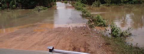

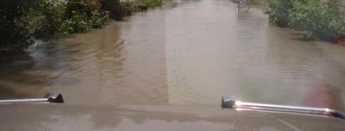
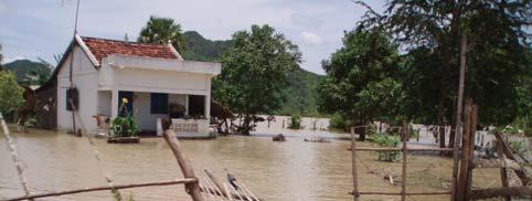
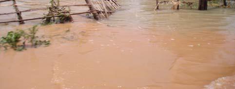
60 Photo Access road (1) Photo Access road (2) Photo Access road (3) Photo Local road (1) Photo Local road (2) Photo Local road (3) REHABILITATION OF RAILWAY IN CAMBODIA Chapter 3 ADB T.A. NO REG Page 32 of 115
61 (2) Track Structure From the point of track maintenance aspect, the use of a same track structure and materials is desirable in one line including its branch lines. Therefore, track structure of branch line shall be same as that of main line. 43 kg/m rails with PC sleepers are recommended in the same standard as the main line structure. Typical cross section of this branch line is shown in Figure Figure Typical Cross Section Construction work for new track structure shall proceed in the following way; i) Prepare subgrade by filling, grading and compacting borrow material ii) Spreading lower ballast layer in 20 cm thick iii) Placing PC sleepers on the ballast and assemble track panel using rail material iv) Spread upper ballast and tamping to adjust the alignment Rail welding is desirable in this section in order to strengthen the track structure and to reduce maintenance cost. REHABILITATION OF RAILWAY IN CAMBODIA Chapter 3 ADB T.A. NO REG Page 33 of 115
62 (3) Bridges and Culverts The access road from the cement factory at Touk Meas to the National Road No. 31 is under construction and is almost complete. The road is 6 km long, 10 m wide and the embankment is 1.5 m tall. It has two 30-m long concrete bridges and 10 pipe culverts. Three design options are available for this branch line. Based on the site survey, the above-mentioned information of the access road, and aerial photos, the following bridges and culverts are required for each of the options. a) Option 1: From the existing Touk Meas Station (PK ) through an old road to the cement factory There are three rivers on the route, which necessitate one 20-m bridge and three 10-m bridges for crossing. To prevent water from flooding the railway embankment and to irrigate the rice fields, a drainage system with one box culvert 3.0 m wide and 2.0 m tall and pipe culverts of φ 1 m at 500-m intervals are needed to discharge the water. b) Option 2: Along the access road to the cement factory There are two rivers on the route; consequently, two 30-m long bridges will be needed for crossing. A drainage and irrigation system with two box culverts, one 3.0 m wide and 2.0 m tall and another 3.0 m wide and 2.5 m tall, is required. In addition, one treerow pipe culvert of φ 1 m and one two-row pipe culvert of φ 1 m are necessary, as well as pipe culverts ofφ 1 m at 500-m intervals. c) Option 3: Along the mountain route (variation of Option 1) to the cement factory There are two rivers on the route. To cross the rivers, one 10-m bridge and one 20-m bridge will be needed. For the drainage and irrigation system, pipe culverts of φ 1 m at 500-m intervals are necessary. No box culvert is required for Option 3. Table below summarizes the civil structures needed for this route. Table Necessary Civil Structures Type Option 1 Option 2 Option 3 Length of Branch Line 5.2 km 7.2 km 5.8 km Bridge L=20 m: 1 L=10 m: 3 L=30 m: 2 L=10 m: 1 L=20 m: 1 Box Culvert 3 m x 2 m: 1 3 m x 2m: 1 3 m x 2.5m: 1 No Pipe Culvert (φ 1 m) L=12 m: 11 L=12 m: 22 L=12 m: 12 (500-m interval) φ 1 m x 3 (500-m interval) φ 1 m x 2 (500-m interval) The Option 2 of this branch line requires a 30-m bridge. For a bridge of this length, an A-2 Type multiple simple span concrete bridge suffices, but a prestressed concrete bridge is also a viable alternative of bridge types. The prestressed concrete bridge requires a double main girder structure consisting of two T-shaped girders. Because the prestressed concrete girder will be made at the factory or at the site of girder erection, it is very important to control the quality of the prestressed concrete. Figure shows the schematic drawing of a 30-m prestressed concrete girder. REHABILITATION OF RAILWAY IN CAMBODIA Chapter 3 ADB T.A. NO REG Page 34 of 115
63 Figure Prestressed Concrete Girder REHABILITATION OF RAILWAY IN CAMBODIA Chapter 3 ADB T.A. NO REG Page 35 of 115
64 3.2.7 Cost Estimate The summary of the estimated project cost is shown in Table Table Summary of Estimated Project Cost (Unit: Million US Dollar) Option 1 Option 2 Option 3 1. Construction Cost F.P. L.P. Total 2. Engineering Service Cost F.P. L.P. Total 3. Administrative Cost F.P. L.P. Total 4. Contingencies F.P. Sub-total ( ) 5. Land Acquisition & Compensation Cost Sub-total ( ) L.P. Total F.P. L.P. Total F.P. L.P. Total F.P. L.P. Total 6. Price Escalation F.P. Total L.P. Total F.P. L.P Total Note) F.P.: Foreign Portion, L.P.: Local Portion REHABILITATION OF RAILWAY IN CAMBODIA Chapter 3 ADB T.A. NO REG Page 36 of 115
65 3.2.8 Selection of Recommended Alignment and Project Implementation Schedule (1) Selection of Recommended Alignment Considering results of hydrological condition and cost estimation of 3 options, Option 3 (along the edge of the mountain route) is recommended as the route for branch line to cement factory at Touk Meas. (2) Project Implementation Schedule Project Implementation Schedule is shown on the figure below. This schedule is prepared based on the assumption that funds from the KC factory will be available from the first quarter of Prior to the procurement of construction contracts, consultants shall be selected to assist the activities of the cement factory. Construction contract is assumed to be commenced from April Construction period of the branch line is estimated as 9 months. No. Work Item Implementation Schedule of Branch Line to Cement Factory at Touk Meas Tender Stage Design-Build Stage B M E B M E B M E B M E B M E B M E B M E B M E B M E B M E B M E B M E 1 Selection of Consultant 2 Preparation of Tender Documents/Drawings 3 Prequalification 4 Tendering 5 Tender Evaluation 6 Negotiation 7 Land Acquisition 8 Notice to Proceed 9 Design 10 Mobilization 11 Temporary Work 12 Procurement of Ballast 13 Procurement of PC Sleepers and the fasteners 14 Procurement of PC 43kg rail 15 Earthwork for Embankment 16 Ballst Spreading & Track Installation 17 Track Adjustment Work 18 Bridge 19 Culvert 20 Level Crossing Construction Work 21 Demobilization 22 Commisioning 23 Completion REHABILITATION OF RAILWAY IN CAMBODIA Chapter 3 ADB T.A. NO REG Page 37 of 115
66 3.3 BRANCH LINE TO CEMENT FACTORIES AT KAMPOT Outline of Branch Line Thai Boon Roong Cement Company is constructing a new cement factory (hereinafter called TBR factory) at 22km Northeast of Kampot station. TBR factory is connected by access road with length of 1km from National Road No.3. The existing cement factory (hereinafter called AZ factory), which has been suspended two years ago, is located between Kampot station and TBR factory at 11km Northeast of Kampot station. AZ factory and Kampot station had been connected by a blanch line. Lafarge Cement Company is also planning to construct a cement factory near AZ factory. However, exact location of Lafarge factory has not been confirmed. According to the information from Thai Boon Roong and Lafarge, they have planed to produce cement from 2008 with capacity of 0.1 million and 0.5 million ton per year, 0.5 million and 1.5 million ton at 2010 respectively. However, so far Thai Boon Roong has no plan to transport by rail at present. Detailed information regarding production forecast is described in Chapter 5. Considering above situation, staged construction plan was provided for this branch line. Section 1 is starting from PK to AZ factory with total length of 11.6 km. Section 2 is new blanch line connecting from AZ factory to TBR factory with total length of 12.7 km. The total length of this branch line is 24.3km. The location of branch line and factories are shown in Figure National Road No.3 Existing Cement Factory (AZ Factory) Northern Entrance Route Section 2 L=12.7km New Cement Factory (TBR Factory) Southern Entrance Route Section 1 L=11.6km Kampot Station PK Figure Branch Line Location Map (Kampot) REHABILITATION OF RAILWAY IN CAMBODIA Chapter 3 ADB T.A. NO REG Page 38 of 115
67 3.3.2 Hydrological Conditions Introduction The proposed railway linkage extends from the existing alignment of about 11.6 km from Kampot station to the AZ cement factory to the Phnom Laang new cement factory, the Thai Bun Roong Factory (TBR) project at a distance about 12.5km from the AZ factory, see Figure Branch Line Location Map (Kampot). The existing line and the proposed extension line are located in the O Roluos sub-catchment, the upper catchment of the Prek Kampong Pou which flow to the Golf of Thailand near Kampot. The existing line crosses a low lying area around Kampot with general land elevation below 10 m and is subject to frequent flood caused by the Stung Tuk Chhou and its tributary, the Stung Sangker. During high flood such as the 2000 and 2006 floods, flows of flood water overtopped over long stretch of the national road RN3 between Kampot and Chakey Ting village near to the AZ Cement factory. The abandoned railway line runs parallel to the RN3 until the AZ cement factory. Major land use of the area is rain fed rice cultivation with high population concentration along major roads and railway embankment around the Prek Kampong Pou flood plain. The extension line runs across the upper part of the O Roluos subcatchment, a sparsely populated area with general land elevation varying between 40m and 20 m. The area is dominated by shrub and grass land, with minimal development activities but new land reclamation is progressively expanding Hydrological Conditions The area is influenced by the coastal rainfall regime with higher rainfall than further inland to the north, especially the area under the shadow effect of the Elephants and Cardamom chain of mountains. The most recent flood recorded in the region are the 1995 (The Typhoon Linda), the 2000 flood and the 2006 flood (from 15 to 20 August 2006). They are widespread floods and cover over large areas. The 2006 flood has high record of rainfall, about 311mm of rain have been observed during the first three days of the storm at Kampot station. Major features influencing surface runoff of the project area are namely: the national road RN3, the abandoned railway embankment between Kampot and AZ cement factory, the embankment of the southern line railway, the national road NR33 between Kampong Trach and Kampot. In addition there are many local roads built across the area. In the Prek Kampong Pou flood plain and estuaries, there are numerous dikes built along the Prek and its estuaries mainly for salt production. The operation and status of those dikes and canals as well as their impacts on the region overland flow are not known. It should also be noted that the Prek Kampong Pou and its flood plain are influenced by tide from the Gulf of Thailand. During high flood (extreme flood), similar to the one in 2000 and the most recent flood of August 2006 flood, most parts of the Kampot town are under water (see Photo ), flood water overtopped a great length of the RN3 from Kampot to the AZ factory (see Photos and ) and the NR 33 between Kampong Trach and Kampot (see Photo ). The southern section of the existing and abandoned railway line which runs almost in parallel to the RN3 could have been also over topped in many places mainly from flow from the western side of the RN3. While the southern line at both sides of the RN3 stand well above flood water, the culvert directly on the eastern side of the RN3 seems suffering from high flow and high velocity (see Photos and ). Photo indicates that flood water entering Kampot from the river side and not through to railway embankment. REHABILITATION OF RAILWAY IN CAMBODIA Chapter 3 ADB T.A. NO REG Page 39 of 115


68 Conclusion and recommendation The proposed extension line runs across the upper part of the O Roluos catchment, crosses O Roluos at a location near to the access road to the AZ cement factory, it follows the north western edge of the southern hills (Phnom Boh Dambang, and Phnom Trasiet). Some small culverts could be foreseen across natural streams draining to the O Roluos. With the help of existing aerial photos, and the provided depth duration intensity table for Kampot station, carrying capacity of each respective culverts could be computed by applying the Rational Methods recommended by the MPWT 5. Between the Phnom Laang and the Trasiet, the proposed new line crosses a low valley, care should be made in the detail design to assure as less as possible to the ecosystem of the surrounding area. The embankment of the existing line seems suffering also from the recent 2000 and 2006 floods from lack of maintenance. Detail survey should be made as soon as possible to assess damage and collect the status of existing water crossing structure. Photo The NR31 between Kampong Trach and Damak Chang Eur on 16 of August 2006 Photo The Kampot road to the market on 16 August 2006 Photo A culvert on the Southern line at the junction with the RN3 on 16 August 2006 Photo The RN 3 near to Kampot on 16 August Road Design Standard Part 3. Drainage CAM PW MWPT, REHABILITATION OF RAILWAY IN CAMBODIA Chapter 3 ADB T.A. NO REG Page 40 of 115

69 Photo Rice field on the left hind side of NR3 on 16 August 2006 Photo Land use near to the edge of the where the railway line is proposed. Photo The Southern Line look from the RN3 on 16 August 2006 REHABILITATION OF RAILWAY IN CAMBODIA Chapter 3 ADB T.A. NO REG Page 41 of 115

70 3.3.3 Geotechnical Conditions (1) General Description of Geotechnical Condition in the Project Area Geological condition of the Project area is divided into two types, tidal flats deposits of Section 1 and pediments of Section 2, which belong to alluvial strata, as shown in Figure Regarding Section 1, there are remaining embankment and structures, which was used for ex-railway before. Height of the embankment is approximately 2m. It means that, the limit embankment height is more than 2m at least, although the ground of the site is classified as soft ground. Hence, it is recommended that the embankment height shall be limited less than 2m to protect slope failure and reduce consolidation settlement. It is recommended that geotechnical examinations such as boring, SPT, and various laboratory tests shall be conducted to decide the countermeasure work more accurately in detail design stage. New Cement Factory Section 2 Section 1 Lafarge Cement Factory Kampot Station Figure Geological Map of Project Area 6 (2) Depth of Bearing Layer for Substructure of Bridges in the Project Area Based on the existing geotechnical data from the other projects, depths of the bearing strata for substructures of bridges around the project area are shown in Figure According to the figure, the deepest bearing strata of 25m range are found at Kampot river. In the other areas, the bearing strata of between 10 to 15m in depth are dominant. 6 Source: MPWT REHABILITATION OF RAILWAY IN CAMBODIA Chapter 3 ADB T.A. NO REG Page 42 of 115
71 The data shown in this section is reference only, and detailed soil investigations at each bridge site shall be carried out to decide the pile lengths in the detailed design stage. Project Site Figure Map of Available Existing Borehole Data and Depth of Bearing Layer (3) Ballast Quarry Site in the Project Area Same quarry site recommended in clause (3) is available for this branch line construction. REHABILITATION OF RAILWAY IN CAMBODIA Chapter 3 ADB T.A. NO REG Page 43 of 115
72 3.3.4 Environmental Issues a) Introduction In additional scope of works of the GMS rehabilitation of the railway in Cambodia prescribed to include new branch line connecting to cement factories in Kampot and Dang Tung district. Three cement factories includes in the area: (1) new cement factory, at Dang Tung district, called TBR factory (Thai Boon Roong Cement Company), (2) existing cement factory (Chakrei Ting) called AZ factory, and (3) new factory near by AZ factory called Lafarge factory, both (2) and (3) located in Kampot district. The environmental issues that expected to occur from project design, construction and operation of this branch line is described in following subtitle. b) Magnitude of the proposed facilities and Alternative Branch line connecting to cement factories at Kampot consist of two sections: section 1 is starting from Kampot station at PK to AZ factory (some part of the track was broken and lost of rail/sleepers) and section 2 is new expansion line from section 1 at AZ factory to TBR factory (see Figure Branch Line Location Map (Kampot)). Two alternative options for Section 2 were proposed namely Northern Entrance Route and Southern Entrance Routes. However the Southern Entrance Route was a preferable for a new construction line to a TBR Cement Factory. The first section will be rehabilitation of existing track with total length of 11.6 km that running parallel to NR3 till AZ factory; second section is new construction line connecting from AZ factory to TBR factory with total length of 12.9 km and running along flooded plain of the valley, appeared by many mountains in the region, then running behind Phnum L ang and connects to southern entrance of the factory. c) Social and Environmental conditions Some communities settled on the both side of the existing alignment in first section since existing cement factory (Chakrei Ting) constructed in 1960s. However more households have been settled in the villages near by the railway after 1990s, but not encroach to the track embankment. In second section of the branch line is passed the rural area with low density of population and not electricity system, unsafe water supply (open well and pond), limited of public services facilities (health centre, school, market, etc.). Most of the people living in the project area are farmer, rained rice field is mostly found and other crop such as corn, beans, pump kin, sugar can, vegetable is also presented in the area. Development activities in the area are agricultural product, salt product, sea product, and cement product. Beside described above the area is a buffer of the tourism zone such as Tuek Chhou, Bokor and Keb recreation/resort, so some people can earn money from tourism activities. An average annual rainfall in last ten years is mm (Kampot Station), some effluent of heavy rainfall (Typhoon rainstorm) from the coastal zone is generally happened in the area. The geomorphology of the area consists of tidal flats (Ft), coastal plain (Cp), pediments (Pd), and quartzite (Csq). Geography of the first section comprises coastal plain and flushed flood of Kamchay catchments with very small sloop (plate) and second section is mostly on the valley of the mountain in the region. The hydrological system in the first section is effluent from Kamchay River which a big catchments of Bokor mountain chain where high density of rainfall ( mm rainfall distribution map, , MoWRAM). Down part of Kamchay river, from Kampot town to sea, called Prek Kampong Bay where much of sedimentation in bottom for many year and no dredging be conducted. Prek Kampong Po has importance role as natural drainage in the area. Near by main line at Prek Kampong Po salt paddy field was found and enlarging year to year. In dry season sea water can dissolve a bit far in Prek REHABILITATION OF RAILWAY IN CAMBODIA Chapter 3 ADB T.A. NO REG Page 44 of 115
73 Kampong Po upstream, passing main railway line at PK 162, but it was flushed back by runoff water in rainy season. Groundwater in shallow aquifer around the Kampot station is brackish and salty, infiltration from the sea water. However depth aquifer had not study yet. In the second section present of some small streams and creeks for instance O Rolous lie on the valley where the proposed alignment was parallel to it. The natural resources here is limestone rock mountain, shrub land and field crop. The main ecological resource is fishery in the low land habitat (in natural lake, pond, rivulet, streams, etc.). However there is not report study to emphasis the specie or number of the fishery in the area. d) Social and Environmental consideration Small encroachment to common rice field and farm land in second section may be occurred due to proposed alignment. Lost of land use and damage crop may be happened in project construction phase. This is insignificant impact; however land acquisition and Detail Measurement Survey (DMS) on affected properties land crop is needed in detail design and before the project implementation. Collaboration with local authority and land management department is very importance to deal with the above issue. Insignificant or minor impact caused by the noise and vibration due to project construction and operation is expected, because the area was calm place with low density of population, no protected area, no wildlife/forest conservation, and no archaeological/cultural resources. The first section of the branch line was faced in high risk of flooding caused by heavy rain (typhoon rainstorm) in the area, for instance high flooded with over flow the national road #3 and railway track, in 1995, 2000, and 2006 (see Photo and ). Track embankment and drainage system along the track in first section of the branch line is needed to consider with properly design to avoid damaging railway and other properties in the area in operation phase. Small impact to the fishery, disturbed fish migration in the area, may be happened caused by combination of development activities such as construction of rural road, dam, access road to factory, and railway branch line. Properly and adequate release structure (culvert and bridge) on the road, dam, and railway should be provided to reduce the impact on the fishery resources in the area. Occasional employment as workers in railway and factory constructions and operation is expected giving more chance to communities living close to the proposed alignment. Priority worker recruitment for the project construction should be provided to local people in place. The branch line to connect cement factories at Kampot and Dang Tung district will provide easy and cheap for the transportation of cement product from three cement factories (AZ, Lafarge, and TBR factory) to Phnom Penh capital as well as to other provinces, and reduce the traffic on the auto-route, reduction of road accident and road maintenance is expected from the project operation too. e) Conclusions and Recommendations Branch line to cement factories that described above will provide some positive environmental and social impacts: - bring in functioning of the existing branch line from Kampot station to existing cement factory (Chakrei Ting = AZ factory) and has new expansion line from AZ factory to TBR factory at Phnum L ang; - reduces traffic on auto-route in the country and reduce road accident and road maintenance - safe and easily for transportation cement product from cement factories, and cheaper cost than other transportation means; and - provides employment chance to local communities in construction and operation phase. REHABILITATION OF RAILWAY IN CAMBODIA Chapter 3 ADB T.A. NO REG Page 45 of 115


74 Insignificant on social and environmental resources in proposed alignment were expected from the project activities such as: - small encroachment to common rice field and shrub land in second section may be occurred in project design and construction phase - small cumulative impact on the hydrological resources and fishery-ecology caused by road, dam, and railway may be happened From the environmental study some importance recommendations can provide in following: - Good collaboration with local authority and land management department to solve small land lost by railway constructed in second section. - Second section alignment shall be running along the mountain leg would be better due to hydrological condition in the area and less of land acquisition too. - Disclosure of the project information/activities to local people is needed before the project implementation to avoid any damage of communities crop on the proposed alignment even it was very small lost as expectation. - The hydrological system in area is very important factor on the environmental impact in the project area, so properly design of drainage structure to ensure flooding here strongly recommended. - Safety facilities shall be installed and education campaign shall provide to the community in construction and operation phase. Photo The environmental condition on proposed alignment in section 2 of the branch line Photo Flooding condition before passing NR3. The branch line from Kampot station to Chakrei Ting factory was flooded Photo Few kilometres flooding NR3 on 17 August 2006 Photo Flooding status on the railway in Kampot area, 17 August 2006 REHABILITATION OF RAILWAY IN CAMBODIA Chapter 3 ADB T.A. NO REG Page 46 of 115
75 3.3.5 Resettlement and Socioeconomic Issues Geographical Coverage The total proposed railway line is 25.1 km, including existing line of 11.6 km, connecting Kampot Railway Station to two cement factories. It cut across eight villages of Kampot and Dang Tong districts. The eight villages are rural having total families of Socioeconomic Profile Socioeconomic information at village level is taken from Commune database 2004 while information at provincial and national levels are taken from Cambodia Socioeconomic Survey The information describe below is a summary. Please see Annex for more information. HOUSEHOLD CHARACTERISTICS The total populations living in the eight villages are (CDB 2004) of which 51.6% are female and is smaller than the provincial average 7 of 52.2% (CSES 2004). The percentage of female-headed household in average is 21.2% and is significantly less than the provincial average of 31.2%. 63 femaleheaded households are reported the mother of one child or more under the age of 5. Average household size is 5.1 and is slightly bigger than provincial average of 5.0 or national average of 5.0. There is no data on poverty rate in each village. However, according to the National Poverty Map the affected communes are rated from 25% to 40% of poverty rate. Economic active persons aged from are 58.7% (male = 28.1% and female = 30.1%), and bigger than the provincial average of 55.4%. Majority of households are farmers, self-employed and sellers. Land and Structure Occupancy In average a household owns less than one hectares of land for rice paddy plus village land. At this stage there is no data on landless people. Land conflict in the area is reported 17 cases in the past year. There are 2104 housing units having moderate to good condition. Percentage of housing units having roof materials as thatch are 38.4%; tile are 16.8%; fibro are 24.1% and zinc are 20.4%. Only three houses have concrete roof. Only 5 households are reported having some irrigated rice land. No data on tenure status at commune and village levels. However, at provincial level, data in 2004 shows that 98.1% is owner, 0.5% is renter, 1.2% is occupier with permission (free) and other is 0.2%. Household Assets There are 1672 households reported having cattle(s) and/or buffalo(s) and 1346 households have pig(s). There is no specific data for other assets per household. However, it is reported that within the eight villages there are 376 motorcycles, 26 tractors/koyons/cars, 895 horse and ox carts, 1317 bicycles, 463 tvs. 7 Provincial average of Kampot and Kep. The two provinces are combined in the CSES 2004 study. REHABILITATION OF RAILWAY IN CAMBODIA Chapter 3 ADB T.A. NO REG Page 47 of 115
76 Sources of Income, Expenditure and Employment Rate There is no specific data at village level in this section. However, according to rapid assessment and interview with some villagers it is found that an average income per household is approximately equal to US$2.5. The main expenditure is for food consumption. There is no or little saving from the income generated. Apart from farming some people have other source of income i.e. stone quarry, fishing and motor-taxi driver. Based on provincial data the employment rate is 64.8% (aged 7+). Environment, Health and WATSAN It is reported that 1655 families used chemical fertilizer and 90 families used pesticide in the past year for agriculture purpose. 40 families used traditional birth attendant and 108 used trained mid-wife in the past year. Women deliver baby in villages have 148 cases in the past year. There are 76 latrines in the eight villages. Numbers of families have access to private pump well or ring well all year round with distance less than 150m are 328 and within 150m of their house are 535. The rest of 1369 families use water from river, pond and rainwater. Education According to village database the illiteracy rate of female and male over 15 years old are 18.4% and 19.0%. Illiteracy rate of female at village level is much lower compare to provincial level rate of female of 36.7%. However, for male, the rate is higher than that of provincial level of 13.8 (CSES 2004). Percentage of female and male aged 6-17 who goes to school is more or less equal 77.1%. Religion and Ethnic Groups No specific data for this section. However, based on interview with villagers the majority of villagers are Khmer ethnic and Buddhism religion and a small portion of Cham (Muslim) Scope of Land Acquisition and Resettlement Framework The proposed railway will be required the total land of 25100m by 13.2m or equal to sqm in order to operationalize the train. The width of 13.2m is included 11.2m bollards and embankment and 2m-pavement reserving for safety. The first 11.6km, or Section 1, from Kampot Station already exist and land acquisition for this section is only 11600m by 2m. For Section 2 of 13.5km presently the land is used primarily for rice farming and a portion of it located along the hillside. According to the Prakas No.06 dated on September 27, 1999 an Order issued by RGC entitled "Measures to Crack Down on Anarchic Land Grabbing and Encroachment set out the right of way for railway in rural area of 50m both side of the rail and 100m from each side of the hillside. However, ADB s policy is to minimize impact as result of resettlement and land acquisition. Therefore, lands located outside the clearance corridor of 13.2m will be remained same of its present tenure status for Section 2. Prakas 06 will be applied for Section 1. However, households who are presently using and occupying the land within the ROW will receive compensation for land use right. The proposed Section 2 of about 3km cuts across the hillside where the land belongs to the public and no need to purchase. Therefore, Only 10.5km of Section 2 will be required to purchase by the Project Authority at replacement cost or market value. The compensation will be paid to all affected households regardless their tenure status to land. REHABILITATION OF RAILWAY IN CAMBODIA Chapter 3 ADB T.A. NO REG Page 48 of 115
77 Impacts and Entitlement The proposed railway line, to some extend, affects to land, other structures, perennial crops and trees, and some community properties. It is estimate that about 558 households will be affected including the minor affect. About 130 households will be affected their [other] structure, basically at the Section 1 and crops and trees, at Section 2. Therefore, households who own property within the clearance corridor will be entitled as the following. - Those whose land is partially affected and the rest are viable for use will be entitled for cash compensation at replacement cost or at market value. - Those whose land is partially affected and the rest are not viable for use will be entitled for replacement land and the non-affected land can be remained by the owner or sale to the Project at the market value. The purchased land will be given to community for public purpose. The household will also entitled for other assistance. - Those whose land is fully affected will be entitled for replacement land and other assistance. - Those whose house and or other structures are affected will be entitled for cash compensation at replacement cost for the affected part. No deduction for salvage materials. Household whose house or main structure is fully affected will received other assistance. - Those whose crops and trees are affected will be entitled for cash compensation at replacement cost. If the affected crops are already harvested by the household no compensation will be paid. - Other assistance includes cost of transport, disturbance allowance, assistance to vulnerable household etc. - Those whose agricultural land is affected more than 10% will be entitled to receive income restoration program. - Those whose business operation will be lost permanently as result of land acquisition will be entitled to receive income restoration program Impoverishment Risks Below table is risk assessment using Impoverishment Risks developed by Michael Cernea in his publication: Risks Assessment and Management in Involuntary Resettlement. Risks Low Medium High Landlessness?? Homelessness x Joblessness and business opportunity x Marginalization x Increase morbidity and mortality?? Food insecurity x Lost of access to common property x Social disarticulation x Therefore, the proposed railway does not have significant resettlement affect except for agriculture land. REHABILITATION OF RAILWAY IN CAMBODIA Chapter 3 ADB T.A. NO REG Page 49 of 115
78 Minimization of Impacts To avoid or minimize impact on main structures especially house the proposed railway should be shifted closed to the hillside. Restoration program for those who lost more than 10% of agriculture land should be properly developed during the resettlement planning Compensation Rates and Resettlement Costs Compensation rate developed for the Northern and Southern line will be adopted for this resettlement costing. The following resettlement cost is based on rough estimate. Items Unit Quantity Rate, Amount US$ Land acquisition Section 1 sqm. 23, , Land acquisition Section 2 hillside sqm. 39, , Land acquisition Section 2 non-hillside sqm. 138, , Affected assets (structure, crop, trees etc.) hhs , Other assistance hhs , Relocation site development - Income restoration hhs , Sub-total 122, Administrative cost (10%) 12, Contingencies (20%) 24, Grand Total 159, REHABILITATION OF RAILWAY IN CAMBODIA Chapter 3 ADB T.A. NO REG Page 50 of 115
79 3.3.6 Preliminary Engineering Design (1) Existing Condition a) Section 1 The length of Section 1 is 11.6km. The track structure of the branch line was removed during civil war. However, the trace of the track is clear and only few encroachments to the track area are observed. Therefore, this old alignment shall be utilized as a route of section 1. The average gradient of this section is about 1.2 and minimum radius curvature is 300m. The condition of the track bed and shoulders are poor because many weeds are growing and local residents are using the track as a footpath to shortcut their walking routes. Erosion of the embankment is found at some locations. Therefore, rehabilitation of track bed and shoulders will be required at whole section. b) Section 2 From AZ factory to TBR factory, two optional routes have been considered. One is entering from northern side of TBR factory, and the other is entering from southern side. The alignment shows that northern entrance route is shorter and accessibility to construction site is better than the southern entrance route. However, considering facilities and building location of the TBR factory, it is preferable to access from southern side. Moreover, southern entrance route can be located inside the premises of cement factory. Therefore, southern entrance route is recommended for this section. The length of Section 2 is 12.9km. The route is running mainly in the rice field and some wasteland area. The change of grand height is gentle. The average gradient of this section is about 2.2 and minimum radius curvature is 600m. There is no big stream which requires bridge structure. The required height of the embankment will be 2m in average. Design characteristics are shown in Section and the alignment drawing of this route is shown in Appendix 9. REHABILITATION OF RAILWAY IN CAMBODIA Chapter 3 ADB T.A. NO REG Page 51 of 115
80 (2) Track Structure From the point of track maintenance aspect, the use of a same track structure and materials is desirable in one line including its branch lines. Therefore, track structure of branch line shall be same as that of main line. 43 kg/m rails with PC sleepers are recommended in the same standard as the main line structure. Typical cross section of this branch line is shown in Figure Figure Typical Cross Section The track structure of the section 1 was removed during civil war. However, the trace of track is clear and this old alignment can be utilized. Section 2 is new track. Construction work for track structure shall proceed in the following way; i) Rehabilitate or Prepare subgrade by filling, grading and compacting borrow material ii) Spreading lower ballast layer in 20 cm thick iii) Placing PC sleepers on the ballast and assemble track panel using rail material iv) Spread upper ballast and tamping to adjust the alignment Rail welding is desirable in this section in order to strengthen the track structure and to reduce maintenance cost. REHABILITATION OF RAILWAY IN CAMBODIA Chapter 3 ADB T.A. NO REG Page 52 of 115
81 (3) Bridges and Culverts This 22 km branch line will be constructed in two phases: Section 1 and Section 2. Section 1: From the existing Kampot Station on the Southern Line of RRC to the existing cement factory. Section 2: From the existing cement factory to the new cement factory, which is under construction. Based on the site survey, the following bridges and culverts are needed for the two sections: a) Section 1 This section bears traces of railway from Kampot Station to the existing cement factory but track materials were removed and a bridge girder was dismantled. To rehabilitate the section, a 10-m bridge and six box culverts 3.0 m in width and 2.5 m in height will need to be completely reconstructed. An irrigation system for the rice fields, consisted of pipe culverts ofφ 1 m at 500-m intervals, shall be installed. b) Section 2 Section 2 from the existing cement factory to the new cement factory will be newly constructed. Bridges will not be needed for this section because of topographical conditions. For the drainage and irrigation system, two box culverts 3.0 m in width and 2.0 m in height are required. Pipe culverts ofφ 1 m at 500-m intervals will be installed. Table summarizes the civil structures needed for this branch line. Table Necessary Civil Structures Type Section 1 Section 2 Length of Section L=11.6 km L=12.9 km Bridge L=10 m: 1 No Box Culvert 3 m x 2.5 m: 6 3 m x 2 m: 2 Pipe Culvert (φ 1 m) 24 (500-m interval) 26 (500-m interval) Figure shows the A1-Type concrete bridge with a length of 10 m. REHABILITATION OF RAILWAY IN CAMBODIA Chapter 3 ADB T.A. NO REG Page 53 of 115
82 Figure A1-Type Concrete Bridge REHABILITATION OF RAILWAY IN CAMBODIA Chapter 3 ADB T.A. NO REG Page 54 of 115
83 3.3.7 Cost Estimate The summary of the estimated project cost is shown in Table Table Summary of Estimated Project Cost 1. Construction Cost F.P. L.P. Total 2. Engineering Service Cost F.P. L.P. Total 3. Administrative Cost F.P. L.P. Total 4. Contingencies F.P. Sub-total ( ) 5. Land Acquisition & Compensation Cost Sub-total ( ) L.P. Total F.P. L.P. Total F.P. L.P. Total F.P. L.P. Total 6. Price Escalation F.P. Total L.P. Total F.P. L.P. Section 1 (to Lafarge Factory) (Unit: Million US Dollar) Section 2 (to New Factory) Total Total Note) F.P.: Foreign Portion, L.P.: Local Portion REHABILITATION OF RAILWAY IN CAMBODIA Chapter 3 ADB T.A. NO REG Page 55 of 115
84 3.3.8 Recommended Alignment and Project Implementation Schedule (1) Recommended Alignment Based on the result of several study and analysis in previous sections, proposed route is recommendable for branch line to cement factory at Kampot. (2) Project Implementation Schedule This branch line has two sections. Project Implementation Schedule for each sections are shown on the figure below. The schedule for Section 1 is prepared based on the assumption that funds from the AZ factory will be available from the first quarter of On the other hand, the schedule for Section 2 is prepared based on the assumption that funds from the TBR factory will be available from the first quarter of Prior to the procurement of construction contracts, consultants shall be selected to assist the activities of these cement factories. Construction contract of each sections are assumed to be commenced from April 2007 and April 2009, respectively. Construction period of each sections are estimated as 9 months, respectively. No. Work Item Implementation Schedule of Branch Line to Cement Factory at Kampot (Section 1) Tender Stage Design-Build Stage B M E B M E B M E B M E B M E B M E B M E B M E B M E B M E B M E B M E 1 Selection of Consultant 2 Preparation of Tender Documents/Drawings 3 Prequalification 4 Tendering 5 Tender Evaluation 6 Negotiation 7 Land Acquisition 8 Notice to Proceed 9 Design 10 Mobilization 11 Temporary Work 12 Procurement of Ballast 13 Procurement of PC Sleepers and the fasteners 14 Procurement of PC 43kg rail 15 Rehabilitation of Existing Embankment 16 Ballast Spreading & Track Installation 17 Track Adjustment Work 18 Bridge Reconstruction 19 Culvert Reconstruction 20 Demobilization 21 Commisioning 22 Completion REHABILITATION OF RAILWAY IN CAMBODIA Chapter 3 ADB T.A. NO REG Page 56 of 115
85 No. Work Item Implementation Schedule of Branch Line to Cement Factory at Kampot (Section 2) Tender Stage Design-Build Stage B M E B M E B M E B M E B M E B M E B M E B M E B M E B M E B M E B M E 1 Selection of Consultant 2 Preparation of Tender Documents/Drawings 3 Prequalification 4 Tendering 5 Tender Evaluation 6 Negotiation 7 Land Acquisition 8 Notice to Proceed 9 Design 10 Mobilization 11 Temporary Work 12 Procurement of Ballast 13 Procurement of PC Sleepers and the fasteners 14 Procurement of PC 43kg rail 15 Earthwork for Embankment 16 Ballst Spreading & Track Installation 17 Track Adjustment Work 18 Culvert 19 Level Crossing Construction Work 20 Demobilization 21 Commisioning 22 Completion REHABILITATION OF RAILWAY IN CAMBODIA Chapter 3 ADB T.A. NO REG Page 57 of 115

86 3.4 BRANCH LINE TO PHNOM PENH PORT (GTW) Outline of the Branch Line Green Trade Warehouse (GTW) is located at 6 km north of Phnom Penh Station. Branch line is starting from main line PK and running parallel with main line till PK From PK 0+950, the branch line is apart from main line and heading to north up to GTW with total length of 6.7 km. The blanch line was constructed at the same time of Northern Line, using 30 km rail with steel sleepers. Beside the marshalling yard in GTW, there are two spur lines passing through World Food Programme (WFP) and CALTEX respectively. There is one spur line into Sokimex from branch line PK with length of 500m. At present, branch line is used by Sokimex only with 1 to 2 trains per week. The freight train transportation service to the CALTEX has been suspended since New spur line will be required to connect Phnom Penh Port Inland Container Depot (ICD) from PK of the branch line. The above mentioned lines are shown in Figure Green Trade Warehouse GTW Yard CALTEX WFP PK ICD PK PK Sokimex Branch Line L=6.7km PK Phnom Penh Station PK Figure Branch Line Location Map (GTW) REHABILITATION OF RAILWAY IN CAMBODIA Chapter 3 ADB T.A. NO REG Page 58 of 115
87 3.4.2 Hydrological Conditions Introduction The Phnom Penh city is located at the junction of four main river branches, the Upper and Lower Mekong, the Tonle Sap and the Bassac rivers. The four river branches form complex river morphology and flow distribution. Most part of the city is built on reclaimed land from the flood plain creating by the four river branches. The city itself is protected from the Mekong high floods by a dyke system which was developed and improved through the years since the city has been created. Drainage of rainfall water and waste water and their disposal are common problem in Phnom Penh especially during heavy rainfall and specifically for the northwestern part of the city where new city expansion has just taken place recently in an un-organized way. Often existing city plan are ignored by the authority of the municipality and no new development plan has been developed. Law and order enforcement related city facility improvement and operation systems are weak. The proposed railway line to be rehabilitated starts from the Phnom Penh station, bypass the Boeung Kak, an important sewage and rainfall water collector lake at the heart of Phnom Penh and then runs almost in parallel with the Tonle Sap River to the Great Lake direction until the Green Trade Warehouse on the Tonle Sap river bank, see Figure Branch Line Location Map (GTW). Generally the railway embankment is higher than the surrounding areas. Major parts of railway embankment surrounding areas are newly developed on lands reclaimed from the river flood plain which once was swampy and serving as excess water retention area. Two pumping stations serve the Boeung Kak, drainage system, of which only one is currently remaining operational. A main canal connects the pumping stations with a water gate at the city ring road near to the Km 6 area on the Tonle Sap. Behind the water gate, the drained water is further transferred to another low lying area behind the city flood protection dike of Kap Srouw to the northern part of the city. Large area at both sides of the main drain has no apparent drainage system, subsequently in many low lying areas, stagnant water remains present during many months of the wet season. In the same way large areas between the city ring road and the Kap Srow flood protection dike has no proper drainage system and risk of local flooding is also increasing with unorganized land fill. Whereas the areas between the railway embankment and the river, waste water and rainfall water are drained directly to the Tonle Sap River through some kind of sewage system. The drains could not be operated during high stage on the Tonle Sap. The drainage system of this part of Phnom Penh needs a comprehensive long term master plan development. Risk of flooding for the surrounding of Phnom Penh has increased considerably in the last few years with speed of widespread of land encroachment from the flood plain and lack of a comprehensive city planning. Development elsewhere in the flood plain such as the currently under study RN8, a planned road across the flood plain at the northeastern side of Phnom Penh could only further increase flood risk for the surrounding of Phnom Penh if flood flow passage has not been given sufficient attention. A comprehensive plan for the development of the areas has not been followed by the municipality authority. Major drainage works implemented in the southern part of the city are mostly financed by donors. In addition to weak technical and law and regulation capacity data collection is also weak. No prevention measures have been taken Urban hydrology In the development of new urban centres, hydrological knowledge of the areas is required at two stages. The first is the planning stage when the general lay-out of the new town is being decided. Estimates of the discharge hydrographs (and corresponding stage hydrographs) for chosen return periods are wanted at a few selected points on the natural water courses in this case open drainage channel, perhaps where water crossing structures are to be constructed. The second stage of hydrological involvement occurs at REHABILITATION OF RAILWAY IN CAMBODIA Chapter 3 ADB T.A. NO REG Page 59 of 115
88 the detailing stage, the designing of the storm water drainage channels and pipes to carry the surface water into the rivers. The principal objective of the planning stage is the determination of the size of flood, with is return period that the planning authority is prepared to accommodate. The design of the drainage system is dependant on a satisfactory assessment of the flood magnitude-return period-relationship and the subsequent of the design flood. The problem of estimating the runoff from the storm rainfall is very much dependant on the character of the catchment surface. The city centres are normally considered as impervious areas where roof areas and large expanses of paved surface of which there is very little of even no part of the ground surface into which rainfall could infiltrate. The calculation of the runoff from these relatively small catchments is the most straightforward, since the area can be easily defined and measured. Over such limited areas, the storm rainfall can be assumed to be uniformly distributed with 100% runoff occurring. The response of the impervious surface is rapid, resulting in a short time of concentration of the flow in the drainage system. The Rational Formula can thus provide the peak discharge: Q(m 3 /s) = A( ha) * i( mm / hr) Conclusion and recommendation Since the railway line to be rehabilitated was constructed well above mean highest ground level of the area, there is no need for consideration of new cross drainage. One consideration which requires further careful analysis is the impact the neighborhood might caused to the railway as temporary refuge during flood disturbing the train traffic and the environment quality of the area and the drainage plan the municipality might consider in the future which could disturb the railway operation in the future including increasing number of squatters along the railway. On the other hand further consideration should be made when there is a need to coordinate in order to establish an effective drainage system in the area, which currently no comprehensive data/information are available for analysis. Data on sewage and rainfall runoff flow did not exist for Phnom Penh. Depth duration frequency distribution established for Pochentong could be used for drainage study for Phnom Penh. Table Depth-Intensity-Duration- Frequency for short duration rainfall at Pochentong Pochentong Depth (mm) Intensity (mm/hr) D/T RRt min min min min h h h h h h h REHABILITATION OF RAILWAY IN CAMBODIA Chapter 3 ADB T.A. NO REG Page 60 of 115
 as shown in Figure 3.4.3.1. Although the ground condition of the site is classified as soft ground, the existing branch line has embankment whose height is 0.5 1m.")
89 3.4.3 Geotechnical Conditions (1) General Description of Geotechnical Condition in the Project Area Geological condition of the Project area is composed of alluvial plain deposits and organic deposits (swamps) as shown in Figure Although the ground condition of the site is classified as soft ground, the existing branch line has embankment whose height is 0.5 1m. Therefore, slope failure and harmful consolidation settlement may not occur because the existing embankment height is not increased in the rehabilitation work. It is recommended that geotechnical examinations such as boring, SPT, and various laboratory tests shall be conducted to decide the countermeasure work more accurately in detail design stage. GTW Phnom Penh Station Figure Geological Map of Project Area 8 8 Source: MPWT REHABILITATION OF RAILWAY IN CAMBODIA Chapter 3 ADB T.A. NO REG Page 61 of 115

90 (2) Depth of Bearing Layer for Substructure of Bridges in the Project Area Based on the existing geotechnical data from the other projects, depths of the bearing strata for substructures of bridges around the project area are shown in Figure According to the figure, the bearing strata of between 10 to 20m in depth are dominant. The data shown in this section is reference only, and detailed soil investigations at each bridge site shall be carried out to decide the pile lengths in the detailed design stage, especially for a pier on the Tonle Sap River, that is expected to have deep bearing strata comparatively. Project Site Figure Map of Available Existing Borehole Data and Depth of Bearing Layer (3) Ballast Quarry Site in the Project Area In this study, quarry site survey and existing material report study were conducted to find some available quarry sites. According to the survey result, two (2) quarry sites are available for this branch construction as follows, although distance between these quarry sites and the project site is far comparatively. REHABILITATION OF RAILWAY IN CAMBODIA Chapter 3 ADB T.A. NO REG Page 62 of 115
, approximately 133km far from the project site, is available for this branch line construction.")
91 Project Site Figure Map of Available Quarry Sites for Ballast < Kampong Trach Quarry Site (along Southern Line) > Same quarry site recommended in clause (3), approximately 133km far from the project site, is available for this branch line construction. < Kampong Chhnang Quarry Site > The quarry is located near Kampong Chhnang airport along the National Road No.5, and approximately 90km far from the project site. According to a staff of the quarry, the current conditions of the quarry are as follows. - Ballast Production Capacity of Existing Crusher: 100m 3 /day. - Unit Cost: 7 USD/m 3 (Price at the site, as of June 2006) - Experience of Ballast Selling to RRC: None. REHABILITATION OF RAILWAY IN CAMBODIA Chapter 3 ADB T.A. NO REG Page 63 of 115
92 3.4.4 Environmental Issues a) Introduction Phnom Penh is capital of Cambodia with total area approximately 400 Km 2 and had population of 1.3 million in The capital located in junction of four rivers namely Mekong up stream, Mekong downstream, Tonle Sap, and Bassac. The existing Phnom Penh Port is situated on the Tonle Sap river with 1km northeast of the city center (Don-Penh Mountain). The present railway terminal, Phnom Penh station, is located at the west of the existing Phnom Penh Port with 1.5 Km distance. b) Magnitude of the proposed facilities Branch Line to Phnom Penh Port at Green Trade Warehouse is one of five additional branch line of the GMS Rehabilitation of the Railway in Cambodia. The existing line here still remaining of rail and sleeper, but 50% of sleeper and some of the rail need to be replaced, according to the evaluation result of current study ( ). The proposed facilities includes (i) rehabilitation of 7.5 km from Phnom Penh station to Green Trade Warehouse (Previous warehouse at Kilometer # 6), (ii) new 670m length connection line at PK to SOKIMEX yard, and (iii) new 560m length connection line at PK to Phnom Penh Port container depot (ICD). See drawing alignment in Figure Branch Line Location Map (GTW). c) Social and Environmental conditions At the present the Phnom Penh city is very fast development activities. Enlargement of urbanization, high industrialization, more setting of commercial centers, and increasing tourism activities have been attracting to rural people migration for the job or make small business. Some infrastructures have been improved to supplementary of the social service peak requirement. Water supply system is most satisfactory improvement with 100% and 80% coverage in downtown and suburb (Annual Report, 2005, PPWSA). Electrical provider is much more increasing their capacity every year to ensure 24 hours supply. Telecommunication system is also satisfactory improved. However road network and sewerage/drainage system are limited improvement. Many places in the city are busy traffic, traffic congestion and traffic jump is happened, in morning/midday and evening time (at the time in and out to the work). Flooded in some areas of the city is happening in every heavy rain in place. Many factories settled in suburb or outskirt of the city with more attractive to rural people come and works there and temporary settlement or renting local house is commonly practiced. Poor sanitations have been occurred in these areas. Some business activities have increased in last few years, for instance few dry ports development was found not far away from city center. Some of them located in western of Phnom Penh airport, one is next to Phnom Penh Port compound, and new development once nearby the railway to Green Trade Warehouse (GTW) with about 5Km from the existing port. The GTW situated at the northwest of the city, on the National Road #5 in previous Kilometer #6 warehouse. The warehouse had existing railway connected but not functioning in last two year and the temporary settlement started encroach to the railway corridor. One second drainage canal of the north part Phnom Penh city connected from Beung Kok to Tonle Sap river at Kilometer #9 where is an outlet of city drainage. The canal is paralleled to railway track from PK to PK and become narrow and shallow by land development activities in the area. Many water hyacinth and garbage densely presented in canal, and some poor stand-pole houses settled on railway embankment and canal space. d) Social and Environmental consideration Removing or shifting some poor settlement on the railway embankment to improve railway corridor from PK to PK will happen in design and construction phase. Disclosure of the project activities to local people is needed before the project implementation and shifting back of temporary REHABILITATION OF RAILWAY IN CAMBODIA Chapter 3 ADB T.A. NO REG Page 64 of 115
93 shops and houses on the existing embankment is required due to improvement of the branch line to Phnom Penh Port. Collaboration with local authority is very importance to deal with the above issue. Many communities living both side of the embankment and use railway corridor for walking, riding bike/motor bike and car, therefore safety facilities and campaign shall provide in construction and operation phase to avoid any dangerous from the project activities. Short environmental impact in construction period and temporary disturbance in operation phase that caused by noise and vibration to communities will be occurred due to the branch line rehabilitation and construction. Lower speed of the train in this area is recommended to reduce noise and vibration, and accident too. Damaging properties and land lost of the community may be happened due to new connection line to SOKIMEX yard and Phnom Penh Port depot and more study on land acquisition and resettlement is required in period of detail design of the project. Compensation should be properly done before the project implementation; payment shall be followed ADB and Government policy guideline and based on the actual rate in place. The new connecting line to Phnom Penh Port depot will build cross the existing drainage so good structure for supporting railway is required, and discussion with sewerage and drainage department of municipality is needed for the final sizing of the structure to avoid water blockage. Branch Line improvement to connect to GTW and new connection line to SOKIMEX yard and Phnom Penh Port depot can reduce congestion traffic on the road way in city and reduce traffic accident caused by the big truck. Improve the environmental conditions in city. Easy, safe, and more benefit for the transportation goods in area comparing to other transportation means. e) Conclusions and Recommendations Branch Line improvement to connect to Green Trade Warehouse and new connection line to SOKIMEX yard and Phnom Penh Port depot can provide much more positive social and environmental impacts: - bring the existing branch railway from terminal station to big combination warehouse (at GTW) functioning after not working for while; - safe and easily for transportation bulk goods in the area, and cheaper cost than other transportation means; - reduce traffic and accident on the road way in city; and - improve environmental condition in city. However insignificant impact can be happened from the project activities in construction and operation phase such as: - small damage when removing and shifting back of temporary shops and houses that encroached on the requirement space for the railway corridor; - damage of some properties of the communities on the proposed new alignment connecting to Phnom Penh port container depot; - land lost and resettle few households in the new connection line to SOKIMEX yard From the environmental study some importance recommendations can provide in following: - Good collaboration with importance stakeholder such as local authority, department of sewage and drainage of municipality, and department of land management to prepare and solve the above issue description. - Disclosure of the project information/activities to local people is needed before the project implementation. - Safety facilities shall be installed and campaign shall provide to avoid any dangerous from the project activities in the community here. REHABILITATION OF RAILWAY IN CAMBODIA Chapter 3 ADB T.A. NO REG Page 65 of 115
94 - Minimum speed of the train in this area is properly practice prevent accident and to reduce noise and vibration. - More study on land acquisition and resettlement is needed in detail design of the project and compensation should be followed ADB and Government policy guideline and based on the actual rate in place. REHABILITATION OF RAILWAY IN CAMBODIA Chapter 3 ADB T.A. NO REG Page 66 of 115
95 3.4.5 Resettlement and Socioeconomic Issues Geographical Coverage The total proposed railway line is 7.4 km, including existing line of 7.2 km, connecting Main Railway Station to three warehouses, including Sokimex, PP dry port and Caltex. It cut across 10 villages of Toulkok and Russei Keo districts. The 10 villages are core urban areas having total families of Socioeconomic Profile Socioeconomic information at village level is taken from Commune database 2004 while information at provincial and national levels are taken from Cambodia Socioeconomic Survey The information describe below is a summary. Please see Annex for more information. HOUSEHOLD CHARACTERISTICS The total populations living in the 10 villages are (CDB 2004) of which 53.5% are female and is bigger than the provincial average of 52.2% (CSES 2004). The percentage of female-headed household in average is 6.0% and is significantly less than the provincial average of 28.6%. 92 female-headed households are reported the mother of one child or more under the age of 5. Average household size is 5.6 and is slightly bigger than provincial average of 5.5. There is no data on poverty rate in each village. However, according to the National Poverty Map the affected communes are rated from 10% to 25% of poverty rate. Economic active persons aged from are 71.1% (male = 32.4% and female = 38.6%), and is bigger than the provincial average of 68.9%. No specific data about occupation of household in each village. However, based on rapid assessment during the field visit, occupation of people in the Project area are garment worker, construction workers, sellers, and government officials. Land and Structure Occupancy It is a built-up area. Each household own land less than 100 sqm. Those who are living along the railway are basically poor household. Land conflict in the area is low reported 35 cases in the past year. There are 7077 housing units having poor, moderate to good condition. Percentage of housing unit having roof materials as thatch are 1.2%; tile are 6.3%; fibro are 7.7%; zinc are 71.9% and concrete are 12.8%. No data on tenure status at commune and village levels. However, at provincial level, data in 2004 shows that 83.8% is owner, 12.6% is renter, 3.3% is occupier with permission (free) and other is 0.3%. Household Assets 5310 families have motorbikes; 764 families have truck/koyons; 1240 families have bicycles; and 6742 families have tvs. Apart from household assets, it is reported that within the villages there are 44 industrial establishments, 101 handicrafts, and 349 small-scale business establishments. Sources of Income, Expenditure and Employment Rate There is no specific data at village level in this section. However, according to rapid assessment and interview with some villagers it is found that an average income per household is approximately equal REHABILITATION OF RAILWAY IN CAMBODIA Chapter 3 ADB T.A. NO REG Page 67 of 115
96 to US$5. The main expenditure is for food consumption, approximately 70%. Based on provincial data the employment rate is 49.8% (aged 7+). This figure is very low compare to Kampot and Kampong Chnang. Data from Socioeconomic survey in the affected area indicates that the average income and expenditure of affected household are US$186 and US$168 per month. More than 70% spend for food consumption. Environment, Health and WATSAN It is reported that 3075 families have access the garbage collection; 5635 families have access to piped water; 6943 families have access to electricity; 6905 families have own latrines. Foe health service, there are 27 clinics and 23 pharmacies in the villages. SES data from the affected area indicated that about 19% of affected household have no own latrine at home; 99% have access to piped water and gridline electricity. As far as environmental issues are concern, severe issues include sanitation 37%, solid waste 40% and drainage 40.6%. Education According to village database the illiteracy rate of female and male over 15 years old are 44.1% and 2.7%. These figures are very high compared to the illiteracy rate at provincial level of 16.2% for female but low compare to 5.3% for male, CSES Percentage of female aged 6-17 who goes to school is 96.0% compare to 97.9% of male. Religion and Ethnic Groups No specific data for this section. However, based on interview with villagers the majority of villagers are Khmer ethnic and Buddhism religion and a small portion of Muslim, Vietnamese and Chinese Scope of Land Acquisition and Resettlement Framework The proposed railway is divided into four sections, including Section 1 of 5000m, Section 2 of 500m, Section 3 of 1700m and Section 4 of 200m. Land acquisition for Section will be 7200m by 6.7m where Section 4 will be 200m by Section is the existing railway line where many settlement and poor community are living along. Section 2 is the most build-up area and settlement are very closed the railway line, leaving the corridor space of less than 4.5m. Section 4 is a new proposed line connecting the Branch line to Phnom Penh dry port. According to the Prakas No.06 dated on September 27, 1999 an Order issued by RGC entitled "Measures to Crack Down on Anarchic Land Grabbing and Encroachment set out the right of way for railway in urban area of 40m both side of the road. However, ADB s policy is to minimize impact as result of resettlement and land acquisition. In this regard, in Section 1+2+3, land located outside the clearance corridor of 6.7m will be remained and continued for use by the existing occupied households. The acquired land within these Sections will not be purchased at market value, as it is the property of the Royal Railway of Cambodia. However, the affected household will receive compensation for land use right. Acquired land in Section 4 will be purchased at present market value. REHABILITATION OF RAILWAY IN CAMBODIA Chapter 3 ADB T.A. NO REG Page 68 of 115
97 Impacts and Entitlement The proposed railway line, to some extend, affects to land, other structures, perennial crops and trees, and some community properties. It is estimate that about 800 households will be affected including the minor affect. About 450 households will be affected their main structure. Therefore, households who own property within the clearance corridor will be entitled as the following. - Those whose land is partially affected and the rest are viable for use will be entitled for cash compensation at replacement cost or at market value. - Those whose land is partially affected and the rest are not viable for use will be entitled for replacement land and the non-affected land can be remained by the owner or sale to the Project at the market value. The purchased land will be given to community for public purpose. The household will also entitled for other assistance. - Those whose land is fully affected will be entitled for replacement land and other assistance. - Those whose house and or other structures are affected will be entitled for cash compensation at replacement cost for the affected part. No deduction for salvage materials. Household whose house or main structure is fully affected will received other assistance. - Those whose standing crops and trees are affected will be entitled for cash compensation at replacement cost. If the affected crops are already harvested by the household no compensation will be paid. - Other assistance includes cost of transport, disturbance allowance, assistance to vulnerable household etc. - Those whose business operation will be lost permanently as result of land acquisition will be entitled to receive income restoration program Impoverishment Risks Below table is risk assessment using Impoverishment Risks developed by Michael Cernea in his publication: Risks Assessment and Management in Involuntary Resettlement. Risks Low Medium High Landlessness x Homelessness x Joblessness and business opportunity x Marginalization?? Increase morbidity and mortality x Food insecurity x Lost of access to common property x Social disarticulation x Therefore, the proposed railway does not have significant resettlement affect except for agriculture land. REHABILITATION OF RAILWAY IN CAMBODIA Chapter 3 ADB T.A. NO REG Page 69 of 115
98 Mitigation and Restoration Measures To avoid or minimize impact on main structures especially house the proposed railway should be cut across the rice field. Restoration program for those who lost more than 10% of agriculture land and lost permanently their business operation must be properly developed during the resettlement planning Compensation Rates and Resettlement Costs Compensation rate developed for the Northern and Southern line will be adopted for this resettlement costing. The following resettlement cost is based on rough estimate. Items Unit Quantity Rate, US$ Amount Land acquisition Section sqm. 14, , Land acquisition Section 4 sqm. 2, , Affected assets (structure, crop, trees etc.) hhs , Other assistance hhs , Relocation site development hhs , , Income restoration hhs , Sub-total 768, Administrative cost (10%) 76, Contingencies (20%) 153, Grand Total 999, REHABILITATION OF RAILWAY IN CAMBODIA Chapter 3 ADB T.A. NO REG Page 70 of 115
99 3.4.6 Preliminary Engineering Design (1) Existing Condition a) Branch Line The branch line alignment with route length of 6.7 km is starting from main line chainage of PK and ended at entrance of GTW yard. Minimum radius curvature is 300m, which is located near PK and PK and gradient of this section is almost level. According to the field survey, it is found that the condition of the rail is fair to good, but that of sleepers are generally poor. More than half of the sleepers are partially or totally covered by weeds and soil. Rusty fishplates and missing bolts are found in many locations. Fresh ballast can not be found in this blanch line. Ballast is contaminated with soil and cemented at whole section. Average width of track bed is about 2.0m to 2.5m and badly eroded track shoulders are found between PK and PK The line and level of track is sub-standard. The place where shops and houses are located along the track, the concreted entrance ways have been built on top of the track bed and shoulders. There are seven level crossings on this branch line, of which, two level crossings are equipped with barrier and the rest of them have no protection. The concrete bridge, length of 15m, is located at PK Based on the survey results, existing rails are generally in good condition for the usage of rehabilitated track, but it is estimated that 70% of sleepers and 50% of fishplates are need to be replaced. The rehabilitation of track bed shall be required in whole section. The embankment with total length of 300m must be rebuilt before setting the track structure. b) GTW yard The GWT yard consists of four storage tracks, one run around track and two loading / unloading tracks. The length of storage tracks varies between 250m and 400m and these have the capacity to hold between 15 and 25 wagons each. The loading / unloading track running through the territory of WFP has length of 500m which can hold 30 wagons. The other loading / unloading track running through the Caltex is mainly used for handling oil for Caltex and has facilities for discharging oil from tank wagons to the storage tank or direct loading to the vessel. The total length of track is approximately 3.5 km and 150 wagons can be accommodated leaving one run around track for locomotives. Track layout of the yard is shown in Fig About one third of track structure is totally covered by soil and weeds. The condition of the rail is generally fair to good, but it is hard to verify the quality of sleepers and turnouts because of hidden by sand and weed growth. Based on the field inspection of the branch line condition, more than half of sleepers might be poor condition. It can be said that, existing rails are generally in good condition for usage of rehabilitated track for marshalling yard, but 50% of sleepers and 30% of fishplates in this section are need to be replaced. Moreover, repair of nineteen turnouts installed in this yard are required. REHABILITATION OF RAILWAY IN CAMBODIA Chapter 3 ADB T.A. NO REG Page 71 of 115
 Spur Line to Sokimex Spur line for Sokimex is starting from PK 4+950 with 280m radius curvature. The track length of this line is 500m up to the entrance gate.")
100 abandoned track Green Trade Warehouse CALTEX WFP To Phnom Penh Station Figure GTW Track Layout c) Spur Line to Sokimex Spur line for Sokimex is starting from PK with 280m radius curvature. The track length of this line is 500m up to the entrance gate. Condition of the rail and sleepers are fair to good but the line and level of track is sub-standard. Shops and houses are encroaching both side of track up to the entrance gate of Sokimex. Existing rail is generally good condition for use as a spur line to Sokimex, but 50% of sleepers in this section are need to be replaced and rehabilitation of track bed shall be required. d) Spur Line to Inland Container Depot (ICD) Access Phnom Penh Port Inland Container Depot (ICD) is under construction near the spur line to Sokimex. Spur line for ICD is starting from PK with 200m radius curvature. The track length of this line is 560m including one arrival/departure track inside the ICD. New spur line can be connected to ICD easily, and crossing canal and road before entering the ICD. Design characteristics are shown in Section and the alignment drawing of this route is shown in Appendix 9. REHABILITATION OF RAILWAY IN CAMBODIA Chapter 3 ADB T.A. NO REG Page 72 of 115
101 (2) Track Structure The branch line to GTW is to rehabilitate the existing track. As described in section (2), the condition of track structure of this line is generally poor. Based on the survey results, existing rails are generally in good condition for the usage of rehabilitated track, but 70% of the existing steel sleepers are need to be replace. 30 kg/m rails with steel sleepers are used in this branch line. Typical cross section of this branch line is shown in Figure Figure Typical Cross Section Rehabilitation work for existing track structure shall proceed in the following way; i) Remove the existing track panel. (Select re-usable steel sleepers and store them in a certain place.) ii) Prepare track bed. iii) Spread new ballast on the track bed. iv) Place new track panel using steel sleepers or salvaged steel sleepers from Southern Line. v) Spread upper ballast and tamping to adjust the alignment. Rail welding is desirable in this section in order to strengthen the track structure and to reduce maintenance cost. REHABILITATION OF RAILWAY IN CAMBODIA Chapter 3 ADB T.A. NO REG Page 73 of 115
102 (3) Bridges and Culverts In this branch line, Section 1 and Section 3 from Phnom Penh Station to the Phnom Penh Port (GTW) are on the existing spur line, which has the following civil structures. Table Existing Structures on the Spur Line to Phnom Penh Port No. PK Structures Type Dimension Concrete Bridge B m Box Culvert BC 5.50 m Appontement (pier) on the Tonle Sap m A structural condition survey of this spur line was carried out to identify the conditions of the existing structures. The concrete bridge at PK and the box culvert at PK are in sound condition but the appontement (pier) at PK is not. A preliminary engineering judgement without detailed inspection of this appontement (pier) categorizes the structure as requiring complete reconstruction. Section 2 and Section 4 will be constructed anew. Section 2 does not require any bridge or box culvert. Section 4 requires one box culvert 3 m in width and 2.5 m in height. Table summarizes the civil structures needed for this branch line. Table Necessary Civil Structures Type Section 1 Section 2 Section 3 Section 4 Length of Section SOKIMEX GTW ICD (500 m) Bridge No No Pier L=166 m No (Complete reconstruction) Box Culvert No No No 3 m x 2.5 m: 1 Pipe Culvert (φ 1 m) No 1 No No Figure shows the drawing of an appontement (pier) on the Tonle Sap. REHABILITATION OF RAILWAY IN CAMBODIA Chapter 3 ADB T.A. NO REG Page 74 of 115

103 Figure An existing appontement (pier) on the Tonle Sap. REHABILITATION OF RAILWAY IN CAMBODIA Chapter 3 ADB T.A. NO REG Page 75 of 115
104 3.4.7 Possibility to Use the Pier in GTW as a Base of Conveyor for Cement Transportation (1) Background As mentioned in (3) Bridges and Culvert of Preliminary Engineering Design, the condition of the pier in GTW is categorized as Complete Reconstruction. However, it means the result as a pier for a base of railway track. In case that the objective of the pier is changed, the category should be also changed. It is expected that the main objective to use the pier is to unload cement. According to the objective, it is studied whether there is a possibility to use the pier as a base of conveyor for cement transport or not. (2) Technical Survey The site survey was conducted on 7 th October 2006 to confirm the current condition of the pier. Conditions of the substructure and reverse side of the superstructure were surveyed from the Tonle Sap river by boat. According to the survey, following conditions are confirmed. vi) There is no serious damaged member. vii) 80% of the substructure is in sound condition. viii) Three of all piers had an experience to be reinforced by steel frames in 1969 due to settlement of girder on the piers. The settlement of the girder is still left and some cracks are found on the girder. ix) There are 20cm - 40cm s openings among girders. x) Reinforcement bars are exposed on some parts of the superstructure. xi) Almost pavement on the deck slab have deteriorated. Schematic survey result of the pier is shown in Figure (3) Result and Recommendation As a result of the site survey, it is judged that the existing pier can play a role as a base of a conveyor for cement transportation without any repair for a while. However, reinforcement bars and steels will be rusted soon if any repair work is not conducted. Therefore, it is recommended to conduct minor repair to extend the remaining life period. The survey data sheet is shown in Figure REHABILITATION OF RAILWAY IN CAMBODIA Chapter 3 ADB T.A. NO REG Page 76 of 115


105 Dameged pile 20cm's opening betw een girders Broken pav ement Re-bar ex posed Almost Substructures are in good condition Figure Schematic Survey Result of the Pier in GTW 40cm's opening betw een girders Reinforced substructure in 1969 Settlement Large Crack Condition of this section could not be checked due to backside of w ingw all. Wingw all REHABILITATION OF RAILWAY IN CAMBODIA Chapter 3 ADB T.A. NO REG Page 77 of 115
 : Steel Structure (G:")
106 Line Name : B.L.to GTW Survey Date: 07 / 10 / 2006 Identified No. : Pier in GTW PK. : N/A Type of Bridge : Concrete Bridge Constructed Year: 1953 Bridge Length : 166 m Bridge Conditions: Concrete Structure (G: Good, C: Cracked, R: Re-bar exposed, B: Broken) : Steel Structure (G: Good, C: Cracked, B: Broken, Co: Corroded) Observation Result: Minor Repair ( i) Complete Reconstruction, ii) Major Repair, iii) Minor Repair, iv) Sound ) Girder : Type : (Steel / RC) Abutment : Type : (RC / Other) Damage : Land side G1: R Damage : Land side A1: - G2: R River side G3: R Pier : Type : (RC / Other) P9: G Damage : Land side P1: - P10: G P2: - P11: R P3: - P12: G P4: G P13: G P5: G P14: G Wing wall: Type : RC / Other P6: G P15: G Damage : Land side A1: R P7: G P16: G P8: G River side P17: G Photo Comments : G1 is settled and partially cracked. P4, P5, and P6 were reinforced in 1969 due to G1's settlement.. Figure Survey Data Sheet REHABILITATION OF RAILWAY IN CAMBODIA Chapter 3 ADB T.A. NO REG Page 78 of 115
107 3.4.8 Cost Estimate The summary of the estimated project cost is shown in Table Table Summary of Estimated Project Cost (Unit: Million US Dollar) Section 1 Section 2 Section 3 Section 4 Total 1. Construction Cost F.P L.P Total Engineering Service Cost F.P L.P Total Administrative Cost F.P L.P Total Contingencies F.P L.P Total Sub-total ( ) F.P L.P Total Land Acquisition & F.P. Compensation Cost Sub-total ( ) L.P. Total F.P. L.P. Total 6. Price Escalation F.P. Total L.P. Total F.P. L.P Total Note) F.P.: Foreign Portion, L.P.: Local Portion REHABILITATION OF RAILWAY IN CAMBODIA Chapter 3 ADB T.A. NO REG Page 79 of 115
108 3.4.9 Recommended Alignment and Project Implementation Schedule (1) Recommended Alignment Based on the result of several study and analysis in previous sections, proposed route which is to rehabilitate the existing track is recommendable for branch line to GTW. (2) Project Implementation Schedule Project Implementation Schedule is shown on the figure below. This schedule is prepared based on the assumption that funds from ADB will be available from the last quarter of Prior to the procurement of construction contracts, consultants shall be selected to assist the activities of PIT (Project Implementation Team). Construction contracts are assumed to be commenced from January Construction period is estimated as 6 months. No. Implementation Schedule of Branch Line to Phnom Penh Port (GTW) Tender Stage Design-Build Stage Work Item B M E B M E B M E B M E B M E B M E B M E B M E B M E 1 Selection of Consultant 2 Preparation of Tender Documents/Drawings 3 Prequalification 4 Tendering 5 Tender Evaluation 6 Negotiation 7 Land Acquisition 8 Notice to Proceed 9 Design 10 Mobilization 11 Temporary Work 12 Procurement of Ballast 13 Procurement of Steel Sleepers and the fasteners 15 Earthwork for Existing Embankment 16 Ballst Spreading & Track Installation 17 Track Adjustment Work 18 Pier in GTW 20 Level Crossing Construction Work 21 Demobilization 22 Commisioning 23 Completion REHABILITATION OF RAILWAY IN CAMBODIA Chapter 3 ADB T.A. NO REG Page 80 of 115
109 3.5 RAIL ACCESS TO PHNOM PENH AIRPORT Outline of Access Line Phnom Penh Airport is located at 8.2 km west of the Phnom Penh city. The nearest railway station to the airport is Pochentong Station (PK 6+723), and next is Fork Station (PK 9+400). Distance between airport and each station are 1.9 km and 2.2 km respectively. Based on the site inspection, it was found that access from Pochentong Station has to passing through a built-up area and there is no space to construct a new railway track structure to the airport. On the other hand, there are many open spaces at south area of Fork Station. Therefore, airport access line will be connected from Fork Station. As for the location of airport station, the consultants recommended to build the station opposite side of the National Road No.3 and connecting with airport terminal by a pedestrian deck. Since the distance between Airport terminal and planned airport station is 100m only, the construction cost of the pedestrian deck will be much more economical than the constructing railway viaduct structure or highway flyover structure. The location of access line is shown in Figure Airport Access Line L= 4.5 km Pedestrian Deck National Road No.3 Figure Access Line Location Map (Phnom Penh Airport) REHABILITATION OF RAILWAY IN CAMBODIA Chapter 3 ADB T.A. NO REG Page 81 of 115
110 3.5.2 Hydrological Conditions Introduction The project area is located in a relatively higher ground outside the Tonle Sap flood plain at a general elevation of 10m, see Figure Access Line Location Map (Phnom Penh Airport). The terrain is generally flat and as any other part of the surrounding of Phnom Penh, the location is a new development area, previously occupied by rice field. The drainage system is mainly controlled by existing infrastructures (road, railway, drainage canal and sewage). The drainage canal and sewage systems are under developed, only the Phnom Penh Airport has appropriate drainage system and facilities Hydrological conditions Major infrastructures influencing the surface water drainage pattern are namely the railway embankments of the southern and northern lines, the national road RN3, RN4, the road joining the Kab Srouw dike. Since the area is apparently on the two water divider, the drainage could use the two existing natural drainage systems: (i) the Preak O Khnea or (ii) using the airport drainage system. The first alternative might be most appropriate due to land accessibility and drained water might be used for crop growing Conclusion and recommendation As any other part of the Phnom Penh municipality especially for newly reclaimed land such as the current project site, the lack of a comprehensive development plan as well as of an organized data collection are major problems in designing individual projects which are related to land surface and sewage drainage. Detail plan could only be realistically done with more detail survey during the implementation phase since landfill in one location near to the project site could have significant impact on the plan. REHABILITATION OF RAILWAY IN CAMBODIA Chapter 3 ADB T.A. NO REG Page 82 of 115

111 3.5.3 Geotechnical Conditions (1) General Description of Geotechnical Condition in the Project Area Geological condition of the Project area is composed of terrace alluvial deposits as shown in Figure According to the field observations, existing ground is classified as soft ground. It is recommended that the embankment height shall be limited less than 2m to protect slope failure and reduce consolidation settlement. It is recommended that geotechnical examinations such as boring, SPT, and various laboratory tests shall be conducted to decide the countermeasure work more accurately in detail design stage. Fork Station Phnom Penh Station Opt. 1 Opt. 2 Phnom Penh Airport Figure Geological Map of Project Area 9 (2) Depth of Bearing Layer for Substructure of Bridges in the Project Area This branch line will have no bridges. (3) Ballast Quarry Site in the Project Area Same quarry sites recommended in clause (3) are available for this branch line construction. 9 Source: MPWT REHABILITATION OF RAILWAY IN CAMBODIA Chapter 3 ADB T.A. NO REG Page 83 of 115
112 3.5.4 Environmental Issues a) Introduction Phnom Penh is capital of Cambodia with total area approximately 400 Km 2 and had population of 1.3 million in The present railway terminal (Phnom Penh station) is located at the town centre. The Phnom Penh International Airport situated at about 7 km west of railway terminal and about 2 km from the main line at Pochetong Area. b) Magnitude of the proposed facilities Branch Line to Phnom Penh Airport will connect from Fork Station at PK and running parallel to Southern line then bending on the left to connect airport at opposite of domestic entrance with total length approximately 5 km. One station and pedestrian desk at connection to airport will provide. See drawing alignment in Figure Access Line Location Map (Phnom Penh Airport). c) Social and Environmental conditions At the present the Phnom Penh city is very fast development in the last few years. Enlargement of urbanization and increasing industrialization to the west side of the city is high potentially happened. Dongkor district is one of boom industrial and township development, where covered the branch line to connect airport. The land price there is very high price stand as second rate after downtown. Many unclear planning constructions of factories and plates are under constructing in the area. Water supply and electricity is available in the recently. However road network and sewerage/drainage system are poor. The highway to Phnom Penh international airport is very busy traffic, traffic congestion and traffic jump is happened, in morning/midday and evening time (at the time in and out to the work). There is not know the Phnom Penh master plan (no main master plan) as well as the development plan in area, for example airport enlargement, industrial development zone, township development, etc. d) Social and Environmental consideration Encroachment to high price land use will happen in design and construction phase. Few households will be resettled caused by the proposed alignment. Disclosure of the project activities to local people is needed before the project implementation and DMS on the land lost by project is required due to proposed branch line to Phnom Penh international airport. Collaboration with local authority and land management department is very importance to deal with the above issue. Purchasing land and compensation costs for damaging properties will be high. Short time of environmental impact in construction period and temporary disturbance in operation phase that caused by noise and vibration to communities will be occurred due to the branch line alignment. Traffic congestion at connection place to the airport will happen and traffic facilitator/police and traffic sign is required in construction and operation phases. Branch Line to Phnom Penh International Airport could not only reduce traffic on the highway in Pochetong area but also can be caused traffic congestion in the connection place in operation phase. Another thing is the branch line seem not interest to the traveller and business men taken it as transportation mean between Phnom Penh airport and Phnom Penh city. e) Conclusions and Recommendations The proposed Branch Line to Phnom Penh Airport can not provide notably positive social and environmental impacts. However some negative social and environmental impact would be occurred from the project design, construction and operation as describes below: REHABILITATION OF RAILWAY IN CAMBODIA Chapter 3 ADB T.A. NO REG Page 84 of 115
113 - complex and costly for land acquisition and resettlement few households; big investment for construction and operation is expected - there is not potential for traveller and business men to taken it as transportation mean between Phnom Penh airport and Phnom Penh city According to negative impact on social and environmental and not any notably positive impact due to project design, construction and operation, so the proposed airport access to Phnom Penh International Airport is not economically investment. REHABILITATION OF RAILWAY IN CAMBODIA Chapter 3 ADB T.A. NO REG Page 85 of 115
114 3.5.5 Resettlement and Socioeconomic Issues Geographical Coverage The total proposed railway line is 5.0 km connecting Phnom Penh Airport to Samrong Railway Station. It cut across 3 villages of Dangkor districts, namely Kakab, Kbal Damrey and Trapeang Chrey. The 3 villages are urban and have total families of Socioeconomic Profile Socioeconomic information at village level is taken from Commune database 2004 while information at provincial and national levels is taken from Cambodia Socioeconomic Survey The information describe below is a summary. Please see Annex in Appendix 11 Resettlement: Socioeconomic Indicator for more information. However, socioeconomic information expressed herewith may be reflect the real affected people as majority of rice field were reportedly sold out to outsiders by the previous owner, the villagers. The proposed railways basically cut across the rice field. HOUSEHOLD CHARACTERISTICS The total populations living in the 3 villages are 2072 (CDB 2004) of which 50.5% are female and is smaller than the provincial average of 52.2% (CSES 2004). The percentage of female-headed household in average is 19.4% and is significantly less than the provincial average of 28.6%. Three female-headed households are reported the mother of one child or more under the age of 5. Average household size is 5.0 and is smaller than provincial average of 5.5. There is no data on poverty rate in each village. However, according to the National Poverty Map the affected communes are rated from 10% to 25% of poverty rate. Economic active persons aged from are 66.9% (male = 31.7% and female = 35.2%), and smaller than the provincial average of 68.9%. No specific data about occupation of household in each village. However, based on rapid assessment during the field visit, occupation of people in the Project area are garment worker, farmer, seller, and government official. Land and Structure Occupancy Only few households own small portion of rice field, less than 0.5 hectares. Land conflict in the area is low reported 3 cases in the past year. There are 341 housing units having moderate to good condition. Percentage of housing unit having roof materials as thatch are 0.1%; tile are 30.4%; fibro are 35.2% and zinc are 33.4%. No single house with concrete roof is reported. No data on tenure status at commune and village levels. However, at provincial level, data in 2004 shows that 83.8% is own, 12.6% is rental, 3.3% is living with permission (free) and other is 0.3%. Household Assets 326 families have motorbikes; 32 families have truck/koyons; 328 families have bicycles; and 370 families have tvs. Apart from household assets, it is reported that within the villages there are 14 industrial establishments, 3 handicrafts, and 11 small-scale business establishments. Sources of Income, Expenditure and Employment Rate REHABILITATION OF RAILWAY IN CAMBODIA Chapter 3 ADB T.A. NO REG Page 86 of 115
115 There is no specific data at village level in this section. However, according to rapid assessment and interview with some villagers it is found that an average income per household is approximately equal to US$4. The main expenditure is for food consumption, approximately 70%. Based on provincial data the employment rate is 49.8% (aged 7+). This figure is very low compare to Kampot and Kampong Chnang. Environment, Health and WATSAN It is reported that 142 families have access the garbage collection; 210 families have access to piped water; 231 families have access to electricity; and 230 families have own latrines. No single clinic or pharmacy is available within the three villages. Education According to village database the illiteracy rate of female and male over 15 years old are 4.0% and 2.5%. These figures are very low compared to the illiteracy rate at provincial level of 16.2% for female and 5.3% for male, CSES Percentage of female aged 6-17 who goes to school is 86.0% compare to 83.0% of male. Religion and Ethnic Groups No specific data for this section. However, based on interview with villagers the majority of villagers are Khmer ethnic and Buddhism religion and a small portion of Vietnamese and Chinese Scope of Land Acquisition and Resettlement Framework The proposed railway will be required the total land of 5000m by 10.2m or equal to sq.m in order to operationalize the train. The width of 10.2m is included 8.2m bollards and embankment and 2m-pavement reserving for safety. At present the land is used primarily for rice field and a small portion of build-up. According to the Prakas No.06 dated on September 27, 1999 an Order issued by RGC entitled "Measures to Crack Down on Anarchic Land Grabbing and Encroachment set out the right of way for railway in urban area of 40m both side of the road. However, ADB s policy is to minimize impact as result of resettlement and land acquisition. Therefore, lands located out side the clearance corridor of 10.2m will be remained same of its present tenure status. The total acquired land will be purchased by the Project Authority at replacement cost or market value. The compensation will be paid to all affected households regardless their tenure status to land Impacts and Entitlement The proposed railway line, to some extend, affects to land, other structures, perennial crops and trees, and some community properties. It is estimate that about 100 households will be affected including the minor affect. About 25 households will be affected their [other] structure and crops and trees. Therefore, households who own property within the clearance corridor will be entitled as the following. - Those whose land is partially affected and the rest are viable for use will be entitled for cash compensation at replacement cost or at market value. REHABILITATION OF RAILWAY IN CAMBODIA Chapter 3 ADB T.A. NO REG Page 87 of 115
116 - Those whose land is partially affected and the rest are not viable for use will be entitled for replacement land and the non-affected land can be remained by the owner or sale to the Project at the market value. The purchased land will be given to community for public purpose. The household will also entitled for other assistance. - Those whose land is fully affected will be entitled for replacement land and other assistance. - Those whose house and or other structures are affected will be entitled for cash compensation at replacement cost for the affected part. No deduction for salvage materials. Household whose house or main structure is fully affected will received other assistance. - Those whose standing crops and trees are affected will be entitled for cash compensation at replacement cost. If the affected crops are already harvested by the household no compensation will be paid. - Other assistance includes cost of transport, disturbance allowance, assistance to vulnerable household etc. - Those whose agricultural land is affected more than 10% will be entitled to receive income restoration program. - Those whose business operation will be lost permanently as result of land acquisition will be entitled to receive income restoration program Impoverishment Risks Below table is risk assessment using Impoverishment Risks developed by Michael Cernea in his publication: Risks Assessment and Management in Involuntary Resettlement. Risks Low Medium High Landlessness x Homelessness x Joblessness and business opportunity x Marginalization x Increase morbidity and mortality?? Food insecurity x Lost of access to common property x Social disarticulation x Therefore, the proposed railway does not have significant resettlement affect except for agriculture land Mitigation and Restoration Measures To avoid or minimize impact on main structures especially house the proposed railway should be cut across the rice field. Restoration program for those who lost more than 10% of agriculture land and lost permanently their business operation must be properly developed during the resettlement planning Compensation Rates and Resettlement Costs Compensation rate developed for the Northern and Southern line will be adopted for this resettlement costing. The following resettlement cost is based on rough estimate. REHABILITATION OF RAILWAY IN CAMBODIA Chapter 3 ADB T.A. NO REG Page 88 of 115
117 Items Unit Quantity Rate US$ Amount Land acquisition sqm. 51, ,785, Affected assets (structure, hhs , crop, trees etc.) Other assistance hhs , Relocation site development - Income restoration hhs , Sub-total 1,801, Administrative cost (10%) 180, Contingencies (20%) 360, Grand Total 2,341, REHABILITATION OF RAILWAY IN CAMBODIA Chapter 3 ADB T.A. NO REG Page 89 of 115
118 3.5.6 Preliminary Engineering Design (1) Existing Condition Access line to Phnom Penh Airport with route length of 4.5km is starting from separation point of Southern and Northern Line at PK Fork Station is required one additional track as arrival and departure for airport access line operation. Airport Station will be one island platform with two tracks. The length of platform is 80m, which can be accommodated maximum of 3 cars train in each track. Minimum radius curvature is 300m and gradient of this section is level. The route is running in the rice field area and there is no big stream or canal which requires bridge structure. The required height of the embankment will be 0.5m in average. Accessibility to the construction site is good. Design characteristics are shown in Section and the alignment drawing of this route is shown in Appendix 9. REHABILITATION OF RAILWAY IN CAMBODIA Chapter 3 ADB T.A. NO REG Page 90 of 115
119 (2) Track Structure As described in section (2), use of 43 kg/m rails with PC sleepers are recommended in the same standard as the main line structure. Typical cross section of this branch line is shown in Figure Figure Typical Cross Section Construction work for new track structure shall proceed in the following way; i) Prepare subgrade by filling, grading and compacting borrow material ii) Spreading lower ballast layer in 20 cm thick iii) Placing PC sleepers on the ballast and assemble track panel using rail material iv) Spread upper ballast and tamping to adjust the alignment Rail welding is desirable in this section in order to strengthen the track structure and to reduce maintenance cost. REHABILITATION OF RAILWAY IN CAMBODIA Chapter 3 ADB T.A. NO REG Page 91 of 115
120 (3) Bridges and Culverts There are two options for this branch line. Based on the site survey, bridges and box culverts will not be necessary for both options. A drainage and irrigation system with pipe culverts of φ 1 m at 500-m intervals shall be installed. Table summarizes the civil structures needed for this branch line. Table Necessary Civil Structures Type Option 1 Option 2 Length L=4.4 km L=4.8 km Bridge No No Box Culvert No No Pipe Culvert (φ 1 m) 10 (500-m interval) 11 (500-m interval) REHABILITATION OF RAILWAY IN CAMBODIA Chapter 3 ADB T.A. NO REG Page 92 of 115
121 3.5.7 Cost Estimate The summary of the estimated project cost is shown in Table Table Summary of Estimated Project Cost (Unit: Million US Dollar) Option 1 Option 2 1. Construction Cost F.P. L.P. Total 2. Engineering Service Cost F.P. L.P. Total 3. Administrative Cost F.P. L.P. Total 4. Contingencies F.P. Sub-total ( ) 5. Land Acquisition & Compensation Cost Sub-total ( ) L.P. Total F.P. L.P. Total F.P. L.P. Total F.P. L.P. Total 6. Price Escalation F.P. Total L.P. Total F.P. L.P. Total Note) F.P.: Foreign Portion, L.P.: Local Portion REHABILITATION OF RAILWAY IN CAMBODIA Chapter 3 ADB T.A. NO REG Page 93 of 115
122 3.5.8 Recommended Alignment and Project Implementation Schedule (1) Recommended Alignment Based on the result of several study and analysis in previous sections, proposed route is recommendable for access line to Phnom Penh Airport. (2) Project Implementation Schedule Project Implementation Schedule is shown on the figure below. This schedule is prepared based on the assumption that funds from ROC will be available from the last quarter of Prior to the procurement of construction contracts, consultants shall be selected to assist the activities of ROC. Construction contracts are assumed to be commenced from January Construction period is estimated as 9 months. No. Work Item Implementation Schedule of Airport Access to Phnom Penh Airport Tender Stage Design-Build Stage B M E B M E B M E B M E B M E B M E B M E B M E B M E B M E B M E B M E 1 Selection of Consultant 2 Preparation of Tender Documents/Drawings 3 Prequalification 4 Tendering 5 Tender Evaluation 6 Negotiation 7 Land Acquisition 8 Notice to Proceed 9 Design 10 Mobilization 11 Temporary Work 12 Procurement of Ballast 13 Procurement of PC Sleepers and the fasteners 14 Procurement of PC 43kg rail 15 Earthwork for Embankment 16 Ballst Spreading & Track Installation 17 Track Adjustment Work 18 Culvert 19 Station Building & Pedestrian Deck 20 Level Crossing Construction Work 21 Signalling & Telecom. Procurement & Installation 22 Demobilization 23 Commisioning 24 Completion REHABILITATION OF RAILWAY IN CAMBODIA Chapter 3 ADB T.A. NO REG Page 94 of 115

, and the distance is about 27 km. National Road No.53 is connecting the station and the city.")
, and the distance is about 20 km. The access road to the station is very poor condition.")

123 3.6 RAIL ACCESS TO KAMPONG CHHNANG AIRPORT Outline of Access Line Kampong Chhnang city is located at 83 km north of Phnom Penh, and Kampong Chhnang Airport is located 11 km west of the city. The railway track is running along the edge of mountain area from Southeast to northwest of the city with distance of 25 to 30 km. Kampong Chhnang city has been developed along Tonle Sab rever. The ground elevation is lowering from southwest mountainous area to northeast Tonle Sab river direction in general. The nearest railway railway station to Kampong Chhnang city is Romeas Station (PK76+458), and the distance is about 27 km. National Road No.53 is connecting the station and the city. First 7 km is paved from the city and remaining is unpaved. The condition of the road is good and well maintained. The nearest station to the Kampong Chhnang Airport is Krang Skear Station (PK ), and the distance is about 20 km. The access road to the station is very poor condition. Only 4 Wheel Drive vehicles can run on this access road. There are three optional routes have been considered for access line from railway station to airport. Option 1 is to construct from Krang Skear Station and running along the existing local road with length of 20.1 km. Option 2 is to construct from Romeas Station considering the shortest way to reach the airport with length of 23.1 km. Option 3 is to construct from Romeas Station and running along the existing road with length of 24.7 km. The location of routes is shown in Fig Figure Access Line Location Map (Kampong Chhnang Airport) REHABILITATION OF RAILWAY IN CAMBODIA Chapter 3 ADB T.A. NO REG Page 95 of 115
124 3.6.2 Hydrological Conditions Introduction The Kampong Chhnang airport is located at about 11 km to the west of the Kampong Chhnang provincial capital directly behind of the group of western hills overlook the Tonle Sap River. The proposed line linking the northern line with the Kampong Chhnang airport starts at the Romeas station at PK for a distance from 25 to 30 km. It runs parallel to the national road RN53 from Romeas station before diverging to the north west direction at a location between Kraing Ta Mom and Prey Mul villages and then turns north at a location near to the Tuk Laak village until the Kampong Chhnang airport, see Figure Access Line Location Map (Kampong Chhnang Airport). From hydrological point of view it could be considered that the proposed connecting line runs almost along the water divider between two sub-catchments of the Tonle Sap namely the Stung Trapeang Kam and Stung Choeung Kriev both tributaries of the Tonle Sap. The topography of this area is relatively flat with elevation varies between 30m near to the junction with the Northern Line to 20 m in the air port area. The most direct road leading from the Romeas railway station to the airport where the proposed linking line will follow could be subdivided in three sections as follows: (i) the national road RN 53, an unpaved road with laterite surface and the embankment well above flood level; (ii) the local road leaving the NR53 between the Prey Mul and Tavak villages on the NR53 ( this road section has been recently improved up to a location where it meets with a cross road north to the Tuk Laak village); (iii) the road section between the intersection linking Phnom Touch to Phum Phnum-Ta Sam (at PT and the airport. This last portion of the section (iv) does not have a complete road; the last few kilometers of this road is consisting only of car tracks without embankment (see Photos ) and small dike at the hill side with a canal running parallel to western edge of the hills. The region has the same climatic conditions as the whole western side of the Tonle Sap Great Lake. The rainfall regime is influenced by the shadow effect of the Cardamom chain of mountains, characterized by an erratic rainfall regime with distinctive wet and dry season. About 90% of rainfall is falling between May to October. Most rainfalls are of convective type. However heavy rainfall could occur when affected by tropical storms originated from typhoon from the South China Sea. Often this period occurs late in the rainy season e.g. September - October when the Tonle Sap Great Lake is at its highest level. For detail rainfall data please refer to the Appendix Hydrological Data. The general land use is rain fed rice with supplement irrigation in small plots extending from the foot of the hills to the west. Villages are scattering around the major local and national roads and higher grounds. The region near to the airport region is sparsely populated. The western side of the northern line part of the catchments is mountainous with sparse to dense forest cover and steep slope Hydrological conditions The general topography of the project area is relatively flat and the overland flows are influenced by the following features, the group of hills at the western side of the Kampong Chhnang town, the national road RN53 linking the Romeas Railway station with the Kampong Chhnang provincial capital, a number of local roads crossing the region, the northern railway line and, most importantly a dike and associate canal of some 30 kilometers long built during the Kampuchea Democratic (DK) period stretching from the Upper Stung Boribor at the provincial border between Kampong Chhnang and Pursat through Kraing Skear in the southeast direction until it meets with the road connecting Andaung Prieng village and Kraing Leav village road where the side canal ceased to exist before changing the direction to the northeast until the Kol Kop village on the NR53 at the eastern side of the Kampong Chhnang western hills. Between Andaung Prieng road and Trapeang Kravan road according to the topographical map, the dike ceased to exist and is followed by the canal until Trapeang Kravan for a section of about 6 km long. REHABILITATION OF RAILWAY IN CAMBODIA Chapter 3 ADB T.A. NO REG Page 96 of 115
125 The cross sections of the dike at one of the breaches point at its intersection with the local road between the Tuk Laak and Prey Mul villages (between PT and PT17.000) is shown in the Photos and Apparently, the dike diverts part of Boribor reservoir water and other smaller river to the east through a canal parallel to the dike. The current status of the dike is not well known due to accessibility and need further investigation for detail design. Reports indicate that there are a number of breaches along the dike. Water flow distribution between Tuk Laak and Trapeang Kravan is quite complicate due to lack of appropriate operational water control structures and other technical information. Surface runoff retained by the dike and conveyed by the canal could be important since it captures all water from the upper catchments of the railway from Romeas to Toul Tbeng Cheu Thom of the northern part of the Northern line. The total catchment area is about 467 Km2. The surface runoff of the airport area is drained by two side canals (see Figure ) built parallel to the runway connecting with a branch of the Stung Preal which forms the Stung Trapeang Kam after crossing the RN5. At its lower part the Stung Trapeang Kam supports a series of small lakes constituting important part of the Tonle Sap River wetland. The local road/dike following the western edge of the Kampong Chhnang hills (section iii) collect surface water from the hills in a side ditch and cross drains to the west through, six pipe culverts (see Photos and ). At the end of the section (iii) at the airport side (PT ), the cross drainage is made by a box culvert (see photo ). Between the junction (PT ), end of the section (iii) and the Tuk Laak village, the side ditch is becoming quite important see photo Part of the flow is drained to the eastern side of the road (see Photo ). The drainage between the junction and Tuk Laak village is from east to west (see Photo ). After the dike towards the RN53, flow on the eastern side is becoming less and less see Photo Along the RN53 there are four water crossing structures most of them bridges with spans over 10 m width; during the site visit it was observed that flow level increases from Romeas to Prey Mul. Typical bridges along this road section are shown in Photo (PT ) and Photo (PT8+000). Flow at the downstream of the bridge in Photo was quite important and almost flooded the side local road. Generally it could be concluded that the existing cross drainage across the RN 53 is satisfactory. However the drainage conditions around Prey Mul, Trapeang Kravan and Tuk Laak village is quite complex due to lack of clear water control infrastructures development and flow concentration in this area. Additional information on future water resources development plan in the area is needed for proper design of the railway connection line Conclusion and recommendation In general, the proposed alignment caused minimal obstruction to the hydrology of the region since it runs almost parallel to existing infrastructures and existing water crossing facilities seems adequate which did not have history of damage due to heavy flood in the region and seems to serve well the drainage of the area with one exception at the DK dike. It is not clear that the breach of the dike was caused by flood or by its removal for local road construction. Further investigation is required on the status of the dikes and related canal and gates in the next phase of the study. There is no flow information available within the area except on the river Boribor at Boribor. Long time series rainfall data is available only for Kampong Chhnang and the depth duration frequency distribution for short duration rainfall is given in Table below. The cross drainage structure computation should follow the MPWT guidelines (reference 3). REHABILITATION OF RAILWAY IN CAMBODIA Chapter 3 ADB T.A. NO REG Page 97 of 115


 of the access road parallel to the proposed line near to junction 4 Rural")
126 Table Depth-Intensity-Frequency of short duration rainfall at Kampong Chhnang Kampong Chhnang Depth (mm) Intensity (mm/hr) D RRt min min min min h h h h h h h Photo Head of side drainage near airport Photo Access road from kampong Chhnang and culvert for side drainage from the hill side Photo Portion (iii) of the access road parallel to the proposed line near to junction Photo Rural road between Trapeang near Kravan and Tuk Laak villages REHABILITATION OF RAILWAY IN CAMBODIA Chapter 3 ADB T.A. NO REG Page 98 of 115


 9 Typical")


 towards")


127 Photo The dike cross section and canal look towards Stung Boribor Photo The dike cross section look towards Kampong Chhnang direction Photo The culvert on RN53 near the junction to Tuk Laak village (PT ) Photo The second bridge from the junction to Romeas (PT8+000) Photo Typical cross drainage near to Kampong Chhnang hills Photo Side canal after the end of the edge of the section (iii), start of section (ii) towards NR53. REHABILITATION OF RAILWAY IN CAMBODIA Chapter 3 ADB T.A. NO REG Page 99 of 115

 12 Eastern side")


128 Photo Drainage to the eastern side of the local road (section ii) Photo Eastern side drainage on local road near to RN53 REHABILITATION OF RAILWAY IN CAMBODIA Chapter 3 ADB T.A. NO REG Page 100 of 115

129 3.6.3 Geotechnical Conditions (1) General Description of Geotechnical Condition in the Project Area Geological condition of the Project area is composed of pediments, which belong to alluvial strata as shown in Figure According to the field observations, existing ground is classified as soft ground. It is recommended that the embankment height shall be limited less than 2m to protect slope failure and reduce consolidation settlement. In addition, regarding Option 1, material for the embankment shall be imported, not side-borrow, due to non-cohesion. It is recommended that geotechnical examinations such as boring, SPT, and various laboratory tests shall be conducted to decide the countermeasure work more accurately in detail design stage. Kampong Chhnang Airport Opt. 1 Opt. 3 Opt. 2 Kraing Skea Station Romeas Station Figure Geological Map of Project Area 10 (2) Depth of Bearing Layer for Substructure of Bridges in the Project Area Based on the existing geotechnical data from the other projects, depths of the bearing strata for substructures of bridges around the project area are shown in Figure According to the figure, it is expected that the bearing strata of between 15 to 20m in depth are dominant. 10 Source: MPWT REHABILITATION OF RAILWAY IN CAMBODIA Chapter 3 ADB T.A. NO REG Page 101 of 115

, is quite available for this branch construction because the quarry is located near Kampong Chhnang airport along the National Road No.")
130 The data shown in this section is reference only, and detailed soil investigations at each bridge site shall be carried out to decide the pile lengths in the detailed design stage. Project Site Figure Map of Available Existing Borehole Data and Depth of Bearing Layer (3) Ballast Quarry Site in the Project Area Kampong Chhnang Quarry Site, which is recommended in clause (3), is quite available for this branch construction because the quarry is located near Kampong Chhnang airport along the National Road No.5, 25 km from Kraing Skear station and 34 km from Romeas station. Project Site Figure Map of Available Quarry Sites for Ballast REHABILITATION OF RAILWAY IN CAMBODIA Chapter 3 ADB T.A. NO REG Page 102 of 115
131 3.6.4 Environmental Issues a) Introduction Kampong Chhnang Airport was constructed in Pol Pot time and proposed as international airport in Cambodia, but it was not completed built and could not use for big aircraft landing since that time. In the same time of airport construction one connected railway line to airport had propose to connect from Kraing Skea station to airport with straight line but it was not completed construction too, remaining embankment about one kilometer length from Kraing Skea station was found. However in additional scope of works of the GMS rehabilitation of the railway in Cambodia prescribed to include new branch line connecting to proposed international airport at Kampong Chhnang. The environmental issues that would be occurred from design, construction and operation of this branch line is described in following subtitle. b) Magnitude of the proposed facilities and Alternative Branch line connecting to proposed new international airport at Kampong Chhnang is a new construction line to connect airport and northern line railway with several alternative options (see Figure Access Line Location Map (Kampong Chhnang Airport)): Option1: Straight line construction to connect Airport with Kraing Skea station as previous proposed alignment in time of airport construction. The total length of this option is approximately 20 km and will pass few communities in Tuek Pos and Rolea B Ier district. Option 2: Connect from Romeas station to airport, first four kilometer from Romeas station is parallel national road #53 and continue straight direction till boundary line between Tuek Phos and Rolea B Iea district then likely bend up to left and connect airport with direction parallel to running way. The total length is approximately 23 km. Option 3: is preferable option for preparing preliminary design of Branch line to connect Kampong Chhnang Airport. This option has approximately 25 km of length, from Romeas station to airport, the alignment has eleven kilometers length parallel to NR53 start from Romeas station and bend up at boundary line between Tuek Phos and Rolea B Iea district then running behind Trapeang Kravan village and Tuek L ak village parallel to rural road from Prey Mul village to Tuek L ak village and connect to airport at same location of Option 1 and Option 2. c) Social and Environmental conditions The following paragraph described the social and environmental condition of the option 3 for the airport access to Kampong Chhnang Airport. The proposed alignment lies on the flooded plain in wet season and no special geographical feature except Phnum Touch and Phnum Ta Bang situated about one to two kilometer from airport. The affected area includes Kraing Leav commune and Romeas commune of Rolea B Iea and Tuek Phos district, Kampong Chhnang provice. Top soil is sandy-loam. Temperature and rainfall is typically ( mm) as other flood plain in Cambodia. In first five kilometers from Romeas station and four kilometers before connecting to airport, the alignment running behind the Veal Sbov village crossing common rice field and running parallel oxcart road before connecting to airport. The partially alignment passes evergreen forests (Photo ), shrubland, and rice field which were common natural resources in the area. The remaining is concerned with social environment because proposed track is passed behind the community living along the REHABILITATION OF RAILWAY IN CAMBODIA Chapter 3 ADB T.A. NO REG Page 103 of 115
132 National Road 53 and rural road from Prey Mul to airport, importance land use of community such as farm and high productive paddy field presented. However there were not valuable natural resources and social resources in project area, based on field investigation of the study team, except small worship (Photo ) and grave found in Krang Ta Mom village and small worship on the mound near alignment connecting to airport was found % of the households here is farmer, so growing rice is main job in the area and second job is sugar pump maker and worker in town. Rained rice field is mostly found in the area. The community is rural area with no electricity system, unsafe water supply (open well and pond), limited of public services facilities (health centre, school, market, etc.). Rural road network ongoing improve and easy to communicate between communities and town. Fencing evergreen forest and cutting forest for land occupation in Krang Ta Mom and Veal Sbov Thmei village where the proposed alignment passing found in current study (August 2006). See Photos d) Social and Environmental consideration Some encroachment to farm land and rice field is commonly happened due to proposed alignment. Lost of land use and damage crop may be occurred due to project design and construction. Disclosure of the project activities to local people, land acquisition and Detail Measurement Survey (DMS) on affected land uses and crop is needed in detail design and before the project implementation. Collaboration with local authority and land management department is very importance to deal with the above issues. Clearing evergreen forest for construction railway at Veal Sbov Thmei village is required, so limited clearing corridor is needed to identify in environmental clause and put it in bidding document for construction of the project. The proposed alignment crosses flood plain of two range mountains on left and right of the track line, therefore drainage structure could be provide properly to ensure flooding in the area. The hydrological system in the area is a bit complex, so more study is needed in detail design phase. Short environmental impact in construction period and temporary disturbance in operation phase that caused by noise and vibration to communities will be occurred due to the branch line alignment. However occasional employment as railway construction worker is expected more chance to communities living close to the proposed alignment. Priority worker recruitment for the project construction should be provided to local people in place. The area will be raised up its value after project implementation and the development activities would be increased in both towns Romeas and Kampong Chhnang. Beside providing safe and easy for the transport of bulks goods to/from the Kampong Chhnang International Airport as a part of external trade development of the country - Branch Line here can provide other transportation mean for local community to travel and transport of goods to Kampong Chhnang, to Romeas town as well as to Phnom Penh city and other province along the railway network. e) Conclusions and Recommendations Branch line to connect Kampong Chhnang Airport can provide some positive social impacts: - the area has a railway from Romeas station to Kampong Chhnang Airport; - safe and easily for transportation bulk goods in/out airport, and cheaper cost than other transportation means; - can provide employment chance to local communities in construction and operation phase; and - increase development activities in the area and improve economic in place and entire country. REHABILITATION OF RAILWAY IN CAMBODIA Chapter 3 ADB T.A. NO REG Page 104 of 115

 and next to oxcart from junction road")

133 Insignificant on social and environmental resources in project alignment were expect from the project activities such as: - encroachment to farm land and rice field and lost of land use and damage crop may be occurred in project design and construction. - small among of evergreen forest will lost by railway construction, at Veal Sbov Thmei village - temporary disturb to community caused by noise and vibration in construction and operation phase From the environmental study some importance recommendations can provide below: m from the national road #53 and rural road (Prey Mul to Tuek L ak village) and next to oxcart from junction road at the end of Tuek L ak village to airport shall be selected to reduce the impact. - Good collaboration with importance stakeholder such as local authority, community development council, department of land management, and other key institution to solve the above issues. - Disclosure of the project information/activities to local people is needed before the project implementation. - additional studies on hydrological system in area is needed in detail design phase and drainage structure to be provided properly to ensure flooding in the area. - Safety facilities shall be installed and safety education campaign shall provide to the community in construction and operation phase. - More study on land acquisition and DMS on damaged properties and lost of land use is required in detail design of the project and compensation should be followed ADB and Government policy guideline and based on the actual rate in place. Photo : Evergreen and rice field in the area Photo : Worship in Krang Ta Mom village Photo : Fencing forest land occupation Photo : Cutting forest for land occupation REHABILITATION OF RAILWAY IN CAMBODIA Chapter 3 ADB T.A. NO REG Page 105 of 115
134 3.6.5 Resettlement and Socioeconomic Issues Among the three options proposed by PPTA Option 3 was selected as the most feasible option for the study Geographical Coverage The total proposed railway line is 24.7 km connecting Kampong Chhnang Airport to Romea Railway Station. It cut across several villages of three communes namely Kraing Leav, Prey Mul and Romeas. There are five villages where the proposed railway cut across settlement namely Teuk La ork, Trapeang Kravan, Trapeang Russei, Kraing Tamom and Veal Sbov. All the five villages are rural and have 905 families Socioeconomic Profile Socioeconomic information at village level is taken from Commune database 2004 while information at provincial and national levels are taken from Cambodia Socioeconomic Survey The information describe below is a summary. Please see Annex in Appendix 11 for more information. HOUSEHOLD CHARACTERISTICS The total populations living in the five villages are 4145 (CDB 2004) of which 54% are female and is bigger than the provincial average of 52.6% (CSES 2004). The percentage of female-headed household in average is 16.2% and is less than the provincial average of 24.4%. 27 female-headed households are reported the mother of one child or more under the age of 5. Average household size is 4.6 and is smaller than provincial average of 4.9 or national average of 5.0. There is no data on poverty rate in each village. However, according to the National Poverty Map the affected communes are rated from 25% to 40% of poverty rate. Economic active persons aged from are 59% (male = 27% and female = 32%), and bigger than the provincial average of 54.7%. Majority of households are farmer. Land and Structure Occupancy In average a household owns about one hectare of land for rice paddy plus village land. Land conflict in the area is low reported 8 cases in the past year. There are 894 housing units having moderate condition. Percentage of housing unit having roof materials as thatch are 49%; tile are 26%; fibro are 10%; and zinc are 15%. There is no single concrete roof house. It is reported that 197 households have some irrigated rice land. No data on tenure status at commune and village levels. However, at provincial level, data in 2004 shows that 96.9% is own, 0.1% is rental and 3.0% is living with permission (free). Household Assets There are 837 households reported having cattle(s) and/or buffalo(s) and 752 households have pig(s). There is no specific data for other assets per household. However, it is reported that within the five villages there are 186 motorcycles, 5 tractors/koyons/cars, 817 horse and ox carts, 666 bicycles, 226 tvs. REHABILITATION OF RAILWAY IN CAMBODIA Chapter 3 ADB T.A. NO REG Page 106 of 115
135 Sources of Income, Expenditure and Employment Rate There is no specific data at village level in this section. However, according to rapid assessment and interview with some villagers it is found that an average income per household is approximately equal to US$2. The main expenditure is for food consumption. There is no or little saving from the income generated. Apart from farming some people have other source of income i.e. collect NTFP and fishing. Based on provincial data the employment rate is 68.9% (aged 7+) Environment, Health and WATSAN It is reported that 680 families used chemical fertilizer and 8 families used pesticide in the past year for agriculture purpose. 21 families used traditional birth attendant and 27 used trained mid-wife in the past year. Women deliver baby in villages have 48 cases in the past year. There are 19 pit latrines in the five villages. Numbers of families have access to private pump well or ring well all year round with distance less than 150m are 381 and within 150m of their house are 454. The rest of 70 families use water from river, pond and rainwater. Education According to village database the illiteracy rate of female over 15 years old are 13.3% and male are 11.5%. These figures are very low compared to the illiteracy rate at provincial level of 43.8% for female and 20.8% for male (CSES 2004). Perhaps, definition of illiterate defined in the two studies may be different. It is interesting to see that percentage of female aged 6-17 who goes to school is higher than that of male, 83.4% compare to 79.2% for male. Religion and Ethnic Groups No specific data for this section. However, based on interview with villagers the majority of villagers are Khmer ethnic and Buddhism religion and a small portion of Cham (Muslim) Scope of Land Acquisition and Resettlement Framework The proposed railway will be required the total land of 24700m by 13.2m or equal to sqm in order to operationalize the train. The width of 13.2m is included 11.2m bollards and embankment and 2m-pavement reserving for safety. At present the land is used primarily for rice farming and some locations are covered by forest, bush and swam. According to the Prakas No.06 dated on September 27, 1999 an Order issued by RGC entitled "Measures to Crack Down on Anarchic Land Grabbing and Encroachment set out the right of way for railway in rural area of 50m both side of the road. However, ADB s policy is to minimize impact as result of resettlement and land acquisition. Therefore, lands located out side the clearance corridor of 13.2m will be remained same of its present tenure status. The acquired land will be purchased by the Project Authority at replacement cost or market value. The compensation will be paid to all affected households regardless their tenure status to land Impacts and Entitlement The proposed railway line will, to some extend, affect to land, structures, perennial crops and trees, and community properties. It is estimate that about 450 households will be affected including the minor REHABILITATION OF RAILWAY IN CAMBODIA Chapter 3 ADB T.A. NO REG Page 107 of 115
136 affect. About 150 households will be affected their structure. Therefore, households who own property within the clearance corridor will be entitled as the following. - Those whose land is partially affected and the rest are viable for use will be entitled for cash compensation at replacement cost or at market value. - Those whose land is partially affected and the rest are not viable for use will be entitled for replacement land and the non-affected land can be remained by the owner or sale to the Project at the market value. The purchased land will be given to community for public purpose. The household will also entitled for other assistance. - Those whose land is fully affected will be entitled for replacement land and other assistance. - Those whose house and or other structures are affected will be entitled for cash compensation at replacement cost for the affected part. No deduction for salvage materials. Household whose house or main structure is fully affected will received other assistance. - Those whose standing crops and trees are affected will be entitled for cash compensation at replacement cost. If the affected crops are already harvested by the household no compensation will be paid. - Other assistance includes cost of transport, disturbance allowance, assistance to vulnerable household etc. - Those whose agricultural land is affected more than 10% will be entitled to receive income restoration program. - Those whose business operation will be lost permanently as result of land acquisition will be entitled to receive income restoration program Impoverishment Risks Below table is risk assessment using Impoverishment Risks developed by Michael Cernea in his publication: Risks Assessment and Management in Involuntary Resettlement. Risks Low Medium High Landlessness?? Homelessness x Joblessness and business opportunity x Marginalization x Increase morbidity and mortality?? Food insecurity x Lost of access to common property x Social disarticulation x Therefore, the proposed railway does not have significant resettlement affect except for agriculture land. REHABILITATION OF RAILWAY IN CAMBODIA Chapter 3 ADB T.A. NO REG Page 108 of 115
137 Mitigation and Restoration Measures To avoid or minimize impact on main structures especially house the proposed railway should be shifted m away from the road where the settlement is located along. Restoration program for those who lost more than 10% of agriculture land should be properly developed during the resettlement planning Compensation Rates and Resettlement Costs Compensation rate developed for the Northern and Southern line will be adopted for this resettlement costing. The following resettlement cost is based on rough estimate. Items Unit Quantity Rate US$ Amount Land acquisition sqm. 326, , Affected assets (structure, crop, trees etc.) hhs , Other assistance hhs , Relocation site development - Income restoration hhs , Sub-total 208, Administrative cost (10%) 20, Contingencies (20%) 41, Grand Total 271, REHABILITATION OF RAILWAY IN CAMBODIA Chapter 3 ADB T.A. NO REG Page 109 of 115
138 3.6.6 Preliminary Engineering Design (1) Existing Condition a) Option 1 Access line to airport with total length of 20.1 km is starting from Krang Skear Station by installing one tounout. Route is running along a local road which is in very poor condition. The road bed is sand or weathered sandstone. Since sand has no cohesion, and thus it is easy to get erosion by rain water, the material is not suitable for embankment. Therefore, suitable borrow material shall be used at this sandy zone. This route needs to pass a big water flow at the south of the airport. Bridge structure and high embankment will be required in the same scale of the existing local road. Minimum radius curvature is 1000m and the average gradient of this route is 3.0. b) Option 2 Access line to airport with total length of 23.1km is starting from 1km north of Romeas Station by installing one turnout. Route is running shortest way to connecting Romeas Station and Airport. The route is running mainly in the rice field and some wasteland. The change of grand height is gentle and there is no big stream which requires bridge structure. The required height of the embankment will be 2.0 m in average. Minimum radius curvature is 1000m and the average gradient of this route is 6.0. c) Option 3 Access line to airport with total length of 24.7km is starting from 1km north of Romeas Station by installing one turnout. About half of the route is running along National Road No.53 and other half is running along well maintained local road up to airport. The route is running mainly in the rice field and some wasteland. The change of grand height is gentle and there is no big stream which requires bridge structure. The required height of the embankment will be 2.0 m in average. Minimum radius curvature is 1000m and the average gradient of this route is 6.0. Recommended Route Considering existing conditions, access from Romeas Station, which is Option 2 & 3, is much better than the Option 1 in many aspects as summarized in Table Table Comparison Table of Options From Romes St. Option 2&3 From Krang Skear St. Option 1 Accessibility to Construction Site Fair Very poor Track Length between Airport and Phnom Penh Ground Condition in general Fair-Poor Very poor Availability of Borrow Material Close Far Availability of Ballast Material Very Close Close As for the Option 2 & 3, Option 3 is 1.6 km longer than the Option 2, but accessibility to construction site is much better than the Option 2. Moreover, Option 3 route is running along the road and passing through villages. New station can be constructed between Airport and Romeas Station when this area is developed and passengers are increased in future. Option 3 route is possible to contribute to the development of the region in future. REHABILITATION OF RAILWAY IN CAMBODIA Chapter 3 ADB T.A. NO REG Page 110 of 115
139 Considering above comparisons, Option 3 is recommended as the route for access line to Kampong Chhnang Airport. Design characteristics are shown in Section and the alignment drawing of this route is shown in Appendix 9. REHABILITATION OF RAILWAY IN CAMBODIA Chapter 3 ADB T.A. NO REG Page 111 of 115
140 (2) Track Structure As described in section (2), use of 43 kg/m rails with PC sleepers are recommended in the same standard as the main line structure. Typical cross section of this branch line is shown in Figure Figure Typical Cross Section Construction work for new track structure shall proceed in the following way; i) Prepare subgrade by filling, grading and compacting borrow material ii) Spreading lower ballast layer in 20 cm thick iii) Placing PC sleepers on the ballast and assemble track panel using rail material iv) Spread upper ballast and tamping to adjust the alignment Rail welding is desirable in this section in order to strengthen the track structure and to reduce maintenance cost. REHABILITATION OF RAILWAY IN CAMBODIA Chapter 3 ADB T.A. NO REG Page 112 of 115
141 (3) Bridges and Culverts Three Options were reviewed and Option 3 was selected as the candidate for the airport access route to Kampong Chhnang Airport. Based on the site survey and aerial photos, Option 3 incorporates the required bridges and culverts in its plan for the branch line. There are four rivers on this route, which necessitate four 10-m bridges for crossing. For the drainage and irrigation system, four box culverts 3.0 m in width and 2.5 m in height are planned and pipe culverts of φ 1 m at 500-m intervals will be installed. Table summarizes the civil structure needed for Option 3 of this branch line. Table Necessary Civil Structures Type Option 3 Length of Branch Line L=24.7 km Bridge L=10 m: 4 Box Culvert 3 m x 2.5 m: 4 Pipe Culvert (φ 1 m) 50 (500-m interval) REHABILITATION OF RAILWAY IN CAMBODIA Chapter 3 ADB T.A. NO REG Page 113 of 115
142 3.6.7 Cost Estimate The summary of the estimated project cost is shown in Table Table Summary of Estimated Project Cost (Unit: Million US Dollar) 1. Construction Cost F.P. L.P. Total 2. Engineering Service Cost F.P. L.P. Total 3. Administrative Cost F.P. L.P. Total 4. Contingencies F.P. Sub-total ( ) 5. Land Acquisition & Compensation Cost Sub-total ( ) L.P. Total F.P. L.P. Total F.P. L.P. Total F.P. L.P. Total 6. Price Escalation F.P. Total L.P. Total F.P. L.P. Total Note) F.P.: Foreign Portion, L.P.: Local Portion REHABILITATION OF RAILWAY IN CAMBODIA Chapter 3 ADB T.A. NO REG Page 114 of 115
143 3.6.8 Recommended Alignment and Project Implementation Schedule (1) Recommended Alignment Based on the result of several study and analysis in previous sections, proposed route is recommendable for access line to Kampong Chhnang Airport. (2) Project Implementation Schedule Project Implementation Schedule is shown on the figure below. This schedule is prepared based on the assumption that funds from ROC will be available from the last quarter of Prior to the procurement of construction contracts, consultants shall be selected to assist the activities of ROC. Construction contracts are assumed to be commenced from January Construction period is estimated as 12 months. No. Work Item Implementation Schedule of Airport Access to Kampong Chhnang Airport Tender Stage Design-Build Stage B M E B M E B M E B M E B M E B M E B M E B M E B M E B M E B M E B M E B M E B M E B M E 1 Selection of Consultant 2 Preparation of Tender Documents/Drawings 3 Prequalification 4 Tendering 5 Tender Evaluation 6 Negotiation 7 Land Acquisition 8 Notice to Proceed 9 Design 10 Mobilization 11 Temporary Work 12 Procurement of Ballast 13 Procurement of PC Sleepers and the fasteners 14 Procurement of PC 43kg rail 15 Earthwork for Embankment 16 Ballst Spreading & Track Installation 17 Track Adjustment Work 18 Culvert 19 Station Building 20 Level Crossing Construction Work 21 Signalling & Telecom. Procurement & Installation 22 Demobilization 23 Commisioning 24 Completion REHABILITATION OF RAILWAY IN CAMBODIA Chapter 3 ADB T.A. NO REG Page 115 of 115
144 4. PRELIMINARY ENGINEERING DESIGN ON SIGNALLING AND TELECOMMUNICATIONS 4.1 TECHNICAL SURVEY OF INFRASTRUCTURE General As for the network of RRC, the Northern line between Cambodia and Thailand was completed in The Southern line between Phnom Penh and the port of Sihanoukville was established in The technical survey for the existing facilities has been done on the area of Northern Line 337 km in length connecting Phnom Penh through Battambang to Sisophon with the spur line, Missing Link 48 km in length between Sisophon and Poipet, Southern Line 262 km in length between Phnom Penh and Sihanoukville with the extension to Sihanoukville port, and the Branch lines in the Royal Railway of Cambodia (RRC) as shown follows Block system The block system on both Southern line between Phnom Penh and Sihanoukville and Northern line between Phnom Penh and Sisophon with the spur line is so called communication block method, as one of non-automatic block systems on single track. In the case of the mentioned block system, the interval between stations is considered to be one block section occupied by only one train. In principle there exists one block between adjacent stations, but some halts for passenger transport service are located in the inter-station sections of the both lines. The block length varies from 3 to 50 km, with the average length of km. (Refer to Table 4.1.1) However, it will be desirable to introduce an automatic block system, a train itself performing blocking in near future, so that in general a non-automatic block system is hardly installed in recent years for safety-operation reasons. REHABILITATION OF RAILWAY IN CAMBODIA Chapter 4 ADB T.A. NO REG Page 1 of 28
145 Table Distance between stations in both lines Northern Line (km) Name of Station Southern Line (km) Name of Station G PHNOM PENH G PHNOM PENH St. POCHENTONG G Bifircation St. BIFIRCATION H Trapaing Krasaing ,50 H SAMRONG H PRATEAS LANG ,20 St. TOUL LEAP H DOEUM ROESS ,50 St. TRAPAING TNOT H PREY TOTOEUNG ,40 St. BAT DOEUNG H ANG PROCH ,90 H TRACH TORNG H SRAS SRE ,60 H DAMNAK SMACH St. KOMAR REACHEA St. TBENG KPOS H TOEUK AMBEL ,40 St. MEANORK H BALEY CHAS ,15 H KRAING LOVEA H SLAKOU ,70 H BARAING G TAKEO ,22 St. ROMEAS St. THAMADA H KRAING SKEAR H ANG KEO ,38 H KDOL St. TANY ,35 St. BAMNAK H TRAM SASAR ,51 H KAMRENG St. TOUK MEAS ,51 H TOTOEUNG THNGAI St. Kompong Trach ,21 G PURSAT H Damnak Chang Oeu ,15 H SNAM PREAH H KAUN SAT ,38 H TRAPAING CHORNG G KAMPOT ,12 St. BOEUNG KNAR H BOKOR ,16 St. SVAY DAUN KEO H KOH TOCH H KALOMPUK H TRAPAING ROPOV ,02 H PREY SVAY St. VEAL RIGN ,26 G MAUNG RUSSEY H SAM HAO H KOH CHAR H ROLUS ,80 H KOK TROM St. THMAR REAP ,50 H PHNOM THIP DEY H OIL REFINERY ,45 H RAING KESSEY G Sihanoukville ,94 H O SRALOA ,37 H O DAMBANG G : Main station ,47 G BATTAMBANG St. : Local station ,08 H SIAM H : Halt ,68 H O TAKY ,16 H CHANDOEUR SVAR H CHROY SDAO ,14 H TOUL SAMRONG ,34 St. PHNOM TAUCH ,06 H CHAMKAR CHEK ,47 St. MONKOL BOREY St. SISOPHON H TOEUK TLAR H SALA SAMRONG H KAUB ,59 G POIPET REHABILITATION OF RAILWAY IN CAMBODIA Chapter 4 ADB T.A. NO REG Page 2 of 28

146 4.13 Train Operation Basically the train operation procedure is executed through radio communication between a station master and each of train drivers. An approval for a train to depart from a station to another station is issued by the Station master at the departing station, keeping a confirmation of the arriving station in advance. Also, a station-staff operates a switch lever near a turn out before a train will depart or arrive at a station. The train decreases in speed when it arrives at a point 600 m from the switch keeping the entrance to the station and shall stop near the switch until an approval information being transmitted with a radio or a hand signal to proceed being indicated. The train dispatch centre is located near Phnom Penh Station, on the other hand, the trains are respectively controlled by the local station master. Figure Weighted switch lever REHABILITATION OF RAILWAY IN CAMBODIA Chapter 4 ADB T.A. NO REG Page 3 of 28

147 Figure Switch lever with indicator Train Radio Also, the existing facilities are designed to allow single track operation in the both lines. The main stations and the cabin in each of trains are equipped with the simplex type of train radio system or public mobile phones as its substitute. Phnom Penh station is equipped with a unified radio base station, which covers communication with each of trains and the stations equipped on both lines. All names of stations being equipped with Radio equipment are shown in Table The above circuit structure is classified as two-way communication between a base and a local station or between a local and a mobile station. As for the simplex method, one frequency is used commonly both for transmission and reception. The base and local/mobile station talk in turn and its method is commonly called as press-to-talk. Occasionally, two frequencies are used, depending on radio interference conditions. (Refer to Figure and Table 4.1.3) REHABILITATION OF RAILWAY IN CAMBODIA Chapter 4 ADB T.A. NO REG Page 4 of 28
 Southern Line Name of Station Phnom Penh; Fork; Bat Deung; Romeas; Bamnok; Kamreing; Toteung Thgnay; Pursat; Svay Don Keo; Mong")
148 Table List of the Stations installed Item Northern Line (14 stations) Southern Line Name of Station Phnom Penh; Fork; Bat Deung; Romeas; Bamnok; Kamreing; Toteung Thgnay; Pursat; Svay Don Keo; Mong Reusey; Phnom Theptey; Battambang; Mongkol Borey; Sisophon Takeo; Tany; Kampong Trach; Kampot; Veal Rinh; (6 stations) Sihanoukville Figure Transmitter/Receiver REHABILITATION OF RAILWAY IN CAMBODIA Chapter 4 ADB T.A. NO REG Page 5 of 28


149 Figure Backup Battery Figure Radio Equipment Pole Antenna REHABILITATION OF RAILWAY IN CAMBODIA Chapter 4 ADB T.A. NO REG Page 6 of 28
150 However, for the time being, the radio system has several troubles about talk quality due to weather conditions and shortage of spare parts. That is the reason why mobile phones as its substitute are often being utilized. Also, the radio equipment is repaired at railway workshops in Phnom Penh. Table Characteristic of Radio Items Content Service Frequencies 5.83MHz 14.39MHz Output Power Circuit Structure Communication type Power Supply / Battery 10 Wattage Two-way communication Simplex (Press-to-Talk) 200 V ac / 12 V 50 AH Along with the increase in number and speed of trains, the necessity of upgraded train radio system as an individual direct communication media between a station master and a train crew as well between a train dispatcher and a train crew will increase to improve traffic control functions. In addition, needs for on-board-passenger information will grow, for example, information regarding train delay and emergency. Therefore, other direct communication media between stationmasters and guards will also be required. From such a viewpoint, it is desirable to introduce the upgraded train radio Signals, Sign and Marker No home or starter signals are composed in station yard and the absolute block section between stations in the both lines. Therefore, the Station master or his staff in charge operates to control a movement of the trains at the station and along the wayside by the handling a hand signal such as a flag in daytime or a lighted lamp at night. There seem no signs and markers such as a station approach sign, station marker, a limit of permanent or temporary speed restriction and a warning post. As for the protection of track works and handling of speed restriction, the track chief applies the station master for the works to be done and in turn ensures that a train is not allowed to enter in the section. Also, flagmen at end of section protect the work group. REHABILITATION OF RAILWAY IN CAMBODIA Chapter 4 ADB T.A. NO REG Page 7 of 28

151 4.1.6 Level Crossings Level crossings have two types, the manned control type with gate barrier and unmanned type without barrier. In addition a marker is of poor one. A train approach warning system and a signal interlocked with a crossing barrier do not exist at level crossings. Furthermore, no a warning post showing that a driver should sound the alarm exists. The existing situation as shown above still seems to be no damage with the current train frequency and its speed, but its countermeasure will be required when increase in train speed and in number in the near future. Figure Level Crossing with unmanned REHABILITATION OF RAILWAY IN CAMBODIA Chapter 4 ADB T.A. NO REG Page 8 of 28

152 Figure Level Crossing with manned control Maintenance of Equipment and its Organization As for the inspection period of equipment, the inspection activities have been no longer carried out for the last 5 years due to the following reasons. Firstly, repairing of the equipments have been done on add hoc basis or as corrective maintenance. Secondary, spare parts related equipments have been no longer available for the last 5 years. As for the above examples, all tools on repair and inspection for radio have not been available for long time ago, and for switch machine have not been originally prepared from the construction stage. The signalling and telecommunications office has been supervised under the Exploitation Department in the Royal Railway of Cambodia. The employees in the office consist of 26 staffs in total, as its breakdown, 4 office staffs, 10 radio operators, 12 repair workers and other. REHABILITATION OF RAILWAY IN CAMBODIA Chapter 4 ADB T.A. NO REG Page 9 of 28
153 4.2 PRELIMINARY ENGINEERING DESIGN OF SIGNALLING AND TELECOMMUNICATIONS Urgent basic plan with required minimum facilities The basic plan of the signaling and telecommunications system on the corresponding lines and the related branch lines depends on the following conditions; (1) Track capacity and number of train planned In general, the track capacity of the single track section is shown as follow. N = 1440 x f / (T + C) where 1440 : 24 h x 60 min./h T : Average running time per train between stations(min.) C : Block handling time (min.) f : Track utilization rate a) Freight train operation only The relationship between track capacity and the number of freight trains planned by RRC is described in Table For only freight train operation, it is proposed that Fork station should be planed two platforms with 3 lines at least due to shortage of track capacity. Table Relationship between tack capacity and the number of freight trains planned Station Distance between stations (km) Track capacity No. of train Freight only Planned (RRC) Sihanoukville - - Kampot Touk Meas Takeo Fork (+2) 14 Phnom Penh Fork Pursat (+1) 6 Battambang Poipet (Remarks) f = 0.75 / C = 1.5 Average speed 50 km/h REHABILITATION OF RAILWAY IN CAMBODIA Chapter 4 ADB T.A. NO REG Page 10 of 28
154 b) Freight/Passenger train operation The relationship between track capacity and the number of both freight and passenger trains planned by RRC is described in Table As for the both train operations, it is pointed out that Fork station should be planed two platforms with 3 lines at least due to shortage of track capacity as well as only freight train operation. Table Relationship between tack capacity and the number of both freight & passenger trains planned Station Distance between stations (km) Track capacity No. of train freight+passenger planned (RRC) Sihanoukville - - Kampot Touk Meas Takeo Fork (+2) 14+4 Phnom Penh Fork Romeas Pursat (+1) 6+6 Maung Russey Battambang Poipet (Remarks) f = 0.75 / C = 1.5 Average speed 60 km/h The stations planned for both freight and passenger trains are described below Figure and Figure Also, a basic diagram for freight & passenger trains planned according to Table is shown in Figure In the following diagram, freight train with cement cargo, freight train with oil cargo and passenger train correspond to a narrow dot line, a thick dot line and a continuous line respectively. REHABILITATION OF RAILWAY IN CAMBODIA Chapter 4 ADB T.A. NO REG Page 11 of 28
155 Station Poipet Battambang Phnom Penh Maung RusseyPursat Romeas Fork Fork Touk Meas Takeo Kampot Sihanoukville Distance (km) Figure Freight and Passenger Station planned Station Poipet Battambang Maung Russey Pursat Phnom Penh Romeas Fork Fork Touk Meas Takeo Kampot Sihanoukville Distance (km) Air Port 8 Port 18 K.C Air Port 8 Cement Factory 22 Cement Factory Figure Freight, Passenger Station including the Branch lines planned REHABILITATION OF RAILWAY IN CAMBODIA Chapter 4 ADB T.A. NO REG Page 12 of 28

156 Figure Diagram for Freight & Passenger trains REHABILITATION OF RAILWAY IN CAMBODIA Chapter 4 ADB T.A. NO REG Page 13 of 28
157 (2) The minimum required facilities In general, the minimum extent to which the current facilities should be needed to be improved depends on the increase in frequency of train operations, train speed, necessary effective length at stations and so forth, according to basic train operation plan shown in Tables and based on traffic demand forecast. However, in order to keep a degree of the better safety, as a result, it is indispensable to introducing a reliable block system, avoiding the collisions between trains on the section. a) Block system (The Special/Restricted Automatic Block system) A block device to ensure safety between trains in a single track section shall be capable of preventing the simultaneous operation of trains running in opposite directions. Also, the safety devices shall be given fail-safe functions to counter breakdowns if they should occur. Particularly on single track sections in the corresponding lines where the number of trains is relatively few, the Special/Restricted Automatic Block equipment, which operates just one train on the section between stations, will be proposed to be installed in order to limit the initial investment and make more economical. In other words, track circuits mid way between stations are omitted and a functional automatic block system is realized by check-in and check-out detection track circuits near the entry and exit of each station. An example of the restricted automatic block equipment on a single track section is illustrated below in Figures and i) Setting of block section The block section consists of station yard and a section between stations. ii) Block section boundaries At start points on the boundary of each block section, home signals, starting signals shall be installed. iii) Mutual linkage of starting signals In particular on single track sections, linkage shall be provided between starting signals at adjoining stations. This means that the direction of train operations between stations is set by installing a pair of traffic direction levers at adjoining stations and operating the levers jointly. REHABILITATION OF RAILWAY IN CAMBODIA Chapter 4 ADB T.A. NO REG Page 14 of 28

158 Figure Restricted Automatic Block Equipment Figure Image of Restricted Automatic Block Equipment REHABILITATION OF RAILWAY IN CAMBODIA Chapter 4 ADB T.A. NO REG Page 15 of 28
159 iv) Signal devices b) Train Detection As for the main signals are entry and exit signals, but block signals are not installed. Shunting signals are installed to shunt the cars or wagons in main station, if necessary.. When necessary, distant signals can be installed as subsidiary signals. Also, Signal aspect system is organized as shown in Figure Also, as for signal aspects, the Exit signal has two signal aspects: Proceed and Stop. The Entry signal has three signal aspects: Proceed, Caution and Stop. Speed-restriction signals are installed in case that work conditions make them necessary only in large station or yards. They are not installed in pass-through stations. The Distant signals have three signal aspects: Proceed, Caution and Stop. The aspects of main signal excluding distant signals, and can not be changed until the trains passes the related track circuits To select the optimum train detection method to be applied for, its method should be comparatively studied with regards to functions, electrical characteristics and construction cost. It is recommended to use Track Circuit instead of Axle Counter while track circuits have more advantage. Comparing the track circuit and axle counter, the former has the following advantages over the latter as explained below: i) In the station yards if one of the axle counters has miscount, it should be re-adjusted and reset is necessary with shunting work which brings additional man power. Therefore, the axle counter system is more costly because countermeasures against erroneous detection by shunting /maintenance cars must be taken by. ii) The tolerance limit of track circuit is higher than axle counter for sensing the train activity when there is very high level of rain or flood. It is more advantageous to adjust the track circuit energy automatically to optimize the use of energy and to increase the performance of track circuits during the bad weather conditions. iii) The track circuits could detect the track breakage easily, in case of necessity of increasing the track capacity, the track circuits could easily expand on all the section in the future. Instead of installing track circuitry on the all sections between stations, the restricted automatic block equipment carries out train detection by check-in check-out using short track circuits installed close to home signals. Also, the system can be called an improvement on the token-less block system. Train detection track circuits are installed at both ends of block sections between stations near entry signals and blocking within yard is assured automatically. REHABILITATION OF RAILWAY IN CAMBODIA Chapter 4 ADB T.A. NO REG Page 16 of 28
160 These detect the entry and exit of trains from block sections and automatically secure blocking. At present, there are hardly any portions where steel sleepers are installed on the Southern line, but, there are almost all sections where steel sleepers are used on the Northern line. Steel sleepers have to be replaced with P.S.C sleepers at station yard and wooden sleepers at point zone. As the types of track circuit, a double-rail DC (Direct Current) track circuit with high sensitivity detection is recommended to be installed. Its control length will be necessary approx. 300 m or more than when installed with the improved sleeper, enabling to reducing its leakage conductance of the track circuit in near future. The mentioned track circuit use DC as the power, it is used when a steady supply of alternating current cannot be obtained in a non-electrified section. The floating-charge lead-acid battery is used for the DC power as shown in Figure Track relays operated by DC track circuits require little power and there is almost attenuation by the rails. As a result, its control length can be relatively long. Figure Configuration on D.C. Track Circuit c) Spring Switch Machine The spring switch machine is a little different from the other switches. The facing train as shown in Figure is permitted to move only in a predetermined direction, but the trailing train as shown in Figure can move in either side direction. Its power is the force produced from the trailing movement of a train, and for restoration, it utilize the force of a spring. Locking for the facing train depends on the force of the controlling spring, a Gelenk being often used. When used under the electric interlocking condition, a magnetic facing point lock is provided. REHABILITATION OF RAILWAY IN CAMBODIA Chapter 4 ADB T.A. NO REG Page 17 of 28
161 In order to operate manual switching, the machine has a handle similar to that of the switch lever with indicator. (Refer to Figures and ) Figure Facing Switch Figure Trailing Switch Figure Spring Switch Machine REHABILITATION OF RAILWAY IN CAMBODIA Chapter 4 ADB T.A. NO REG Page 18 of 28
 Railway Crossing Warning Facilities Railway crossing warning facilities shall be capable of informing the approach of a train to passers-by using the")
162 Figure Image of Spring Switch Machine on site d) Railway Crossing Warning Facilities Railway crossing warning facilities shall be capable of informing the approach of a train to passers-by using the crossing road and of shutting down traffic on such a road with the approach of a train. They must be at least capable of informing that a train is approaching even if other operations are impossible due to the specific circumstances of the facilities. Railway crossing warning facilities should have an additional device to inform of an obstruction on a crossing road by an automobile if such an additional device is deemed to be necessary considering the train speed, traffic volume on the road and railway track and types of passing automobiles, etc. As for the function of warning control, the warning starts when the train passes the entry point A or C shown in Figure and finishes when it passes the exit point B shown in Figure In other word, once the train has passed the entry point, the warning at the level crossing must continue while the train occupies between the entry point and exit point. REHABILITATION OF RAILWAY IN CAMBODIA Chapter 4 ADB T.A. NO REG Page 19 of 28
163 Figure Standardized Train Entry/Exit Detection in single track It is necessary to install the following types of warning equipment on level crossings depending on the range of the road traffic volumes. Moreover, these systems shall possess fail-safe functions. i) Level crossing alarm The device uses two red flashing lights and an alarm bell to warn people using the level crossing. A standard time of 30 seconds or more is set from the start of the alarm sound to arrival of train, etc. at the level crossing. (Refer to Figure ) ii) Crossing gate The device closes off the level crossing with a gate barrier when trains pass through, and is installed on major level crossings. The gate barrier is controlled manually. iii) Train approach display The device uses a display light and alarm to indicate the approach of trains, etc. to gateman at major level crossing. iv) Markers On level crossings, it is necessary to install warning markers, etc. to inform passers-by that a level crossing exists there. Crossing Alarm Bell Warning Market Warning Lamp Train Direction Indicator Foundation Figure Level crossing alarm REHABILITATION OF RAILWAY IN CAMBODIA Chapter 4 ADB T.A. NO REG Page 20 of 28
164 e) Telecommunication facilities Replacement and Reinforcement of radio system is necessary to achieve the full and reliable coverage of the lines. The performance and construction cost of the Radio system depends on available radio frequency, the number of its frequencies, external noise on frequency band-width, the output of its transmitter, and the height of antenna. At this stage VHF channel radio system is effective method and for an example, one of the radio systems may be established that the base station located at main railway stations situated about 70~80 km apart and local station located at railway stations between the base stations. The following equipments would be provided at the station and the dispatcher centre: i) Radio Transmitter and Receiver ii) iii) Antenna, Towers and Feeders Power Supplies and Batteries iv) others. Also, VHF radio communication has the following main functions: i) Block radio telephone In order to communicate the operation procedure between adjacent stations ii) Dispatch radio telephone In order to communicate the train operation adjustment between train dispatcher and stations iii) Mobile radio (Train radio and Portable radio) In order to communicate between a station and a train crew for emergency, between a dispatcher and a train crew for operation conditions. In order to communicate between station staff, operation staff and maintenance staff for operations. In addition, the restricted/special automatic block equipment at stations links together with the Fibre optic cables. The Fibre optic cables connects in every about 20km A future Improvement and Upgrading Plan It is recommended that the improvement and upgrading plan should be accomplished with increase in frequency and in speed of train operation in the following. REHABILITATION OF RAILWAY IN CAMBODIA Chapter 4 ADB T.A. NO REG Page 21 of 28
165 Block system should be improved, upgrading to prevent rear-on collision as well as head-on collision. Next, in order to contribute efficient operation of train and to improve a degree of safety by keeping the locking and interlocking of signals and switches, the Interlocking devices should be installed. Also, level crossing protection system should be advanced to avoid crossing accidents as well as to raise the attention of the passers-by according to each of traffic situations. In the future, it will be necessary to introduce Centralized Traffic Control for controlling the train operation along with remote control of a number of signals in an extensive control section from the control centre. (1) Automatic Block System on a single track section At first stage, the special/restricted automatic block equipment should be changed to the automatic block equipment on single track section. Setting and handling of block for automatic block system are the same as that of special/restricted automatic block system. As for the automatic block system, block section protected by block signals and continuous track circuits between stations are installed, enabling to operate plural trains in the same direction. Generally speaking, the latter will provides a track capacity approximately 10% greater than that of the former. As a result, all trains in stations and between stations can be detected at the location of occupied track circuit as well as rail breakage. An example of automatic block equipment on a single track section is illustrated below in Figure Figure Automatic block system on a single track section (2) Automatic Block System on Double Track Section At next stage, with further increase in number of train and in train speed, it is recommended that automatic block system on double track section should be introduced in parallel with improvement construction of the lines with double track. REHABILITATION OF RAILWAY IN CAMBODIA Chapter 4 ADB T.A. NO REG Page 22 of 28
166 The track capacity for double track sections is estimated from the operated train type and the combination of the kinds of trains, running time between stations, difference in running times between higher speed trains and lower speed trains and other factors. Therefore, track capacity also varies widely with the role of the line. Figure Automatic block system on double track section (3) Level Crossing Safety Facilities It is necessary to install the crossing gate control equipment as well as crossing warning equipment on level crossings depending on the range of the road traffic. The level of protection to be provided for level crossing should be considered according to the status of each road crossing. Crossing gate control equipment closes off the level crossing with a cross-arm when trains pass through installed on major level crossings. Moreover, these devices should possess fail-safe functions. (4) Interlocking Device Main stations and the junction with the branch line and at crossings should be installed with interlocking device in order to keep the safety of train route, being capable of mutually interlocking a route and other signals and points which may disrupt operation on the route. (5) Centralized Traffic Control Centralized traffic control operations consist of a display sequence for collecting train operation data from stations, and a control sequence for controlling train routes. The functions are summarized as follows: The dispatchers at the control centre determine the train operating status from the display board and set the station route levers at control board accordingly. The controller transmits the route settings to the stations. The station equipment selects the route control for its section, and transmits the control commands to the relevant signals and switching devices. (refer to Figure ) REHABILITATION OF RAILWAY IN CAMBODIA Chapter 4 ADB T.A. NO REG Page 23 of 28
167 Figure Basic Configuration of Centralized Traffic Control (6) Telecommunications Facilities a) Radio System Replacement and Reinforcement of radio system is necessary to achieve the full and reliable coverage of the lines. The performance and construction cost of the Radio system depends on available radio frequency, the number of its frequencies, external noise on frequency band-width, the output of its transmitter, and the height of antenna. At this stage VHF channel radio system is effective method and for an example, one of the radio systems may be established that the base station located at main railway stations situated about 70~80 km apart and local station located at railway stations between the base stations. The following equipments would be provided at the station and the dispatcher centre: i) Radio Transmitter and Receiver ii) iii) Antenna, Towers and Feeders Power Supplies and Batteries iv) others Also, VHF radio communication has the following main functions: i) Block radio telephone In order to communicate the operation procedure between adjacent stations ii) Dispatch radio telephone REHABILITATION OF RAILWAY IN CAMBODIA Chapter 4 ADB T.A. NO REG Page 24 of 28
168 In order to communicate the train operation adjustment between train dispatcher and stations iii) Mobile radio (Train radio and Portable radio) In order to communicate between a station and a train crew for emergency, between a dispatcher and a train crew for operation conditions. In order to communicate between station staff, operation staff and maintenance staff for operations. b) Fibre optic cable In near future, a railway telephone network will be needed with extensions in many offices, stations, rolling stock workshop, maintenance offices and so forth. PBX users are generally restricted to one area where the switchboard is. However, in a railway telephone network, the subscribers are distributed linearly along the track, and lines tend to be long, because it is preferable for one switchboard to handle as many subscribers as possible. Also, optical-fibre telecommunications systems will be necessary to built because those have many advantages over conventional copper cables, including resistance to induced signals, high insulation, low loss, and wide-band transmission. Therefore, partially the system linking with the fibre optic cables in every about 20 km is recommended to install the block circuit for the restricted/special automatic block equipment between stations. Optical telecommunications have come into wide spread use due to recent mass-production of low loss optical fibres and long life, high performance laser diodes for electro-optic signal conversion. Optical equipment can transmit vastly more data than conventional equipment. REHABILITATION OF RAILWAY IN CAMBODIA Chapter 4 ADB T.A. NO REG Page 25 of 28

169 4.3 PRELIMINARY COST ESTIMATE ON SIGNALLING AND TELECOMMUNICATIONS Preliminary cost estimate is taken into consideration based on Basic Block Control System as shown below in Figure Figure Basic Block Control System REHABILITATION OF RAILWAY IN CAMBODIA Chapter 4 ADB T.A. NO REG Page 26 of 28
KINGDOM OF CAMBODIA MINISTRY OF PUBLIC WORKS AND TRANSPORT RAILWAY DEPARTMENT
 KINGDOM OF CAMBODIA MINISTRY OF PUBLIC WORKS AND TRANSPORT RAILWAY DEPARTMENT Fifth Meeting of the Working Group on the Trans-Asian Railway Network And Global Smart Rail Conference Busan, Republic of Korea,
PRESENTATION For The Meeting of Land Transport Sub TWG
 KINGDOM OF CAMBODIA MINISTRY OF PUBLIC WORKS AND TRANSPORT Railway Department PRESENTATION For The Meeting of Land Transport Sub TWG Presented by CHREUNG Sok Tharath Deputy Director of Railway Department
Railway Development of Cambodia
 KINGDOM OF CAMBODIA Regional Meeting on Harmonization of Rule and Regulation for Facilitation of International Railway Transport Astana,Kazakhtan,20-21 December 2017 Railway Development of Cambodia Seng
ECONOMIC AND FINANCIAL ANALYSIS
 South Asia Subregional Economic Cooperation Dhaka Northwest Corridor Road Project, Phase 2 (RRP BAN 40540) A. Introduction ECONOMIC AND FINANCIAL ANALYSIS 1. The proposed project primarily aims at capacity
Ex-Ante Evaluation (for Japanese ODA Loan)
") Japanese ODA Loan Ex-Ante Evaluation (for Japanese ODA Loan) 1. Name of the Project Country: India Project: Delhi Mass Rapid Transport System Project Phase 2 (V) Loan Agreement: March 31, 2010 Loan Amount:
Japanese ODA Loan Ex-Ante Evaluation (for Japanese ODA Loan) 1. Name of the Project Country: India Project: Delhi Mass Rapid Transport System Project Phase 2 (V) Loan Agreement: March 31, 2010 Loan Amount:
Study on Economic Partnership Projects. in Developing Countries in FY2010. Study on the Kiev Metro Line 4 in Kiev City, Ukraine SUMMARY.
 Study on Economic Partnership Projects in Developing Countries in FY2010 Study on the Kiev Metro Line 4 in Kiev City, Ukraine SUMMARY March 2011 第 1 章 第 2 章 The Ministry of Economy, Trade and Industry
Feasibility Study for Promotion of International Infrastructure Projects in FY2011
 Feasibility Study for Promotion of International Infrastructure Projects in FY2011 STUDY ON THE EXPANSION OF RAIL TRANSPORT CAPACITY FOR ROCK PHOSPHATE, THE KINGDOM OF MOROCCO FINAL REPORT SUMMARY November
ECONOMIC AND FINANCIAL ANALYSIS: PROJECT 1
 Integrated Road Investment Program (RRP SRI 47273) A. Introduction ECONOMIC AND FINANCIAL ANALYSIS: PROJECT 1 1. Sri Lanka s road network is dense and well laid out, providing basic access to the country
Kingdom of Cambodia. Ministry of Public Works and Transport. Ministry of Rural Development WORKSHOP ON
 Kingdom of Cambodia Ministry of Public Works and Transport Ministry of Rural Development WORKSHOP ON PLANNING, PAVEMENT DESIGN AND OVERLOADING PREVENTION The Damaging Effects Of Overloaded Heavy Vehicles
ECONOMIC AND FINANCIAL ANALYSIS
 Second Jharkhand State Road Project (RRP IND 49125) ECONOMIC AND FINANCIAL ANALYSIS A. Introduction 1. The project involves capacity augmentation and rehabilitation of four state highway sections in the
Presented by : H.E. Mr. KEM Borey Date: 09 th December /58
 Presented by : H.E. Mr. KEM Borey Date: 09 th December 2015 0/58 OUTLINES 1. Mission, Functions and Organization of MPWT 2. Background and Current Situation of Road Infrastructure 3. Policy and Strategy
Japanese ODA Loan. Ex-ante Evaluation
 Japanese ODA Loan Ex-ante Evaluation 1.Name of the Project Country:Republic of the Philippines Project:Capacity Enhancement of Mass Transit Systems in Metro Manila Project Loan Agreement:27 March 2013
Country Report 9. Lao PDR Country Report. Leeber Leebouapao National Economic Research Institute. March 2008
 Country Report 9 Lao PDR Country Report Leeber Leebouapao National Economic Research Institute March 2008 This chapter should be cited as Leebouapao, L. (2008), Lao PDR Country Report, in Soesastro, H.
The project faces a number of challenges:
 On-Track Light Rail Project The Ministry of Transport of the city of Gotham is proposing to construct an elevated 20- kilometer light rail transit (LRT) with 5 passenger stations, connecting several nearby
Back ground Founded in 1887, and has expanded rapidly Altitude about 2500 meters above MSL Now among the ten largest cities in Sub Saharan Africa
 Back ground Founded in 1887, and has expanded rapidly Altitude about 2500 meters above MSL Now among the ten largest cities in Sub Saharan Africa Annual growth rate is 3.8% By 2020 population growth would
SECTOR ASSESSMENT (SUMMARY): ROAD TRANSPORT
: ROAD TRANSPORT") Road Network Upgrading Project (RRP TIM 45094) Sector Road Map SECTOR ASSESSMENT (SUMMARY): ROAD TRANSPORT 1. Sector Performance, Problems, and Opportunities 1. Timor-Leste comprises the eastern half of
Road Network Upgrading Project (RRP TIM 45094) Sector Road Map SECTOR ASSESSMENT (SUMMARY): ROAD TRANSPORT 1. Sector Performance, Problems, and Opportunities 1. Timor-Leste comprises the eastern half of
ASIAN DEVELOPMENT FUND (ADF) ADF XI REPLENISHMENT MEETING 7 9 March 2012 Manila, Philippines. Post-Conflict Assistance to Afghanistan
 ADF XI REPLENISHMENT MEETING 7 9 March 2012 Manila, Philippines. Post-Conflict Assistance to Afghanistan") ASIAN DEVELOPMENT FUND (ADF) ADF XI REPLENISHMENT MEETING 7 9 March 2012 Manila, Philippines Post-Conflict Assistance to Afghanistan February 2012 ABBREVIATIONS ADB Asian Development Bank ADF Asian Development
ASIAN DEVELOPMENT FUND (ADF) ADF XI REPLENISHMENT MEETING 7 9 March 2012 Manila, Philippines Post-Conflict Assistance to Afghanistan February 2012 ABBREVIATIONS ADB Asian Development Bank ADF Asian Development
Sustainable Human Resource Development in logistics services for ASEAN Member States
 The Training Material on Cross Border Transport Operation has been produced under Project Sustainable Human Resource Development in Logistic Services with the support from Japan-ASEAN Integration Fund
Considerations in Improving the International Connectivity in Asia-Pacific Region. China Academy of Information and Communication Technology Chen Hui
 Considerations in Improving the International Connectivity in Asia-Pacific Region China Academy of Information and Communication Technology Chen Hui International Connectivity is the Need for ICT Development
Submission to Greater Cambridge City Deal
 What Transport for Cambridge? 2 1 Submission to Greater Cambridge City Deal By Professor Marcial Echenique OBE ScD RIBA RTPI and Jonathan Barker Introduction Cambridge Futures was founded in 1997 as a
Disaster Prevention and Rehabilitation Project (Philippine-Japan Friendship Highway and Naguilian Road)
") Philippines Disaster Prevention and Rehabilitation Project (Philippine-Japan Friendship Highway and Naguilian Road) 1. Project Profile and Japan s ODA Loan Report Date: March 2001 Field Survey: September
Philippines Disaster Prevention and Rehabilitation Project (Philippine-Japan Friendship Highway and Naguilian Road) 1. Project Profile and Japan s ODA Loan Report Date: March 2001 Field Survey: September
Session 1: Implementing SDG 7 and Achieving Target 7.1 CAMBODIA CHHE LIDIN
 Session 1: Implementing SDG 7 and Achieving Target 7.1 CAMBODIA Seminar on Supporting Sustainable Development Goal 7, Target 7.1 By 2030 ensure universal access to affordable, reliable and modern energy
CITY OF LONDON STRATEGIC MULTI-YEAR BUDGET ADDITIONAL INVESTMENTS BUSINESS CASE # 6
 2016 2019 CITY OF LONDON STRATEGIC MULTI-YEAR BUDGET ADDITIONAL INVESTMENTS BUSINESS CASE # 6 STRATEGIC AREA OF FOCUS: SUB-PRIORITY: STRATEGY: INITIATIVE: INITIATIVE LEAD(S): BUILDING A SUSTAINABLE CITY
4 COSTS AND OPERATIONS
 4 COSTS AND OPERATIONS 4.1 INTRODUCTION This chapter summarizes the estimated capital and operations and maintenance (O&M) costs for the Modal and High-Speed Train (HST) Alternatives evaluated in this
Transport Sector Performance Indicators: Sri Lanka Existing Situation
 Transport Sector Performance Indicators: Sri Lanka Existing Situation Amal S. Kumarage Professor, Department of Civil Engineering, University of Moratuwa Chairman, National Transport Commission kumarage@sltnet.lk
Aim: Integration of Road Infrastructure of Georgia with European Standards and effective satisfaction of the Road User needs. Annual Report 2013
 www.georoad.ge Annual Report 2013 Aim: Integration of Road Infrastructure of Georgia with European Standards and effective satisfaction of the Road User needs Objectives: Improvement of road safety Reduction
Study for the Possibility of Application of Ultra Super Critical Steam Conditions for Coal Fired Power Plant in Vietnam
 Feasibility Studies with the Aim of Developing a Bilateral Offset Credit Mechanism FY2011 Studies for Project Development and Organization Study for the Possibility of Application of Ultra Super Critical
Highway 18 BNSF Railroad Overpass Feasibility Study Craighead County. Executive Summary
 Highway 18 BNSF Railroad Overpass Feasibility Study Craighead County Executive Summary October 2014 Highway 18 BNSF Railroad Overpass Feasibility Study Craighead County Executive Summary October 2014 Prepared
Note: The October 2007 version of this report has been updated in this December 2008 report to present costs in year 2007 dollars.
 Sound Transit Phase 2 South Corridor LRT Design Report: SR 99 and I-5 Alignment Scenarios (S 200 th Street to Tacoma Dome Station) Tacoma Link Extension to West Tacoma Prepared for: Sound Transit Prepared
SECTOR ASSESSMENT (SUMMARY): URBAN TRANSPORT
: URBAN TRANSPORT") Vientiane Sustainable Urban Transport Project (RRP LAO 45041) Sector Road Map SECTOR ASSESSMENT (SUMMARY): URBAN TRANSPORT 1. Sector Performance, Problems, and Opportunities 1. Road transport dominates
Vientiane Sustainable Urban Transport Project (RRP LAO 45041) Sector Road Map SECTOR ASSESSMENT (SUMMARY): URBAN TRANSPORT 1. Sector Performance, Problems, and Opportunities 1. Road transport dominates
ECONOMIC SURVEY STATISTICAL APPENDIX
 ECONOMIC SURVEY 2017-18 STATISTICAL APPENDIX STATISTICAL APPENDIX : ECONOMIC SURVEY 2017-18 PAGE 1 National Income and Production 1.1 Gross National Income and Net National Income... A1-A2 1.2 Annual
STUDY ON THE DEVELOPMENT OF LEBAK BULUS STATION AREA IN JAKARTA THE REPUBLIC OF INDONESIA
 STUDY ON ECONIMIC PARTNERSHIP PROJECTS IN DEVELOPING COUNTRIES IN FY2012 STUDY ON THE DEVELOPMENT OF LEBAK BULUS STATION AREA IN JAKARTA THE REPUBLIC OF INDONESIA FINAL REPORT SUMMARY February 2013 Prepared
A Forward March towards an Energy Empowered Nation Case Study in Sri Lanka
 A Forward March towards an Energy Empowered Nation Case Study in Sri Lanka Menaka Rajaguru Department of External Resources Ministry of National Policies and Economic Affairs Country Profile Country Profile
STRATEGIC PRIORITIES AND POLICY COMMITTEE MAY 5, 2016
 STRATEGIC PRIORITIES AND POLICY COMMITTEE MAY 5, 2016 Shift Rapid Transit Initiative Largest infrastructure project in the city s history. Rapid Transit initiative will transform London s public transit
COMMERCIALISATION OF UGANDA S OIL AND GAS SECTOR: REFINERY AND ATTENDANT INFRASTRUCTURE DEVELOPMENT
 MINISTRY OF ENERGY AND MINERAL DEVELOPMENT COMMERCIALISATION OF UGANDA S OIL AND GAS SECTOR: REFINERY AND ATTENDANT INFRASTRUCTURE DEVELOPMENT Dr. Stephen Robert Isabalija PERMANENT SECRETARY 13 th -15
Three ULTra Case Studies examples of the performance of the system in three different environments
 Three ULTra Case Studies examples of the performance of the system in three different environments airport application: London Heathrow : linking business and staff car parks through the access tunnel
SECTOR ASSESSMENT (SUMMARY): ROAD TRANSPORT. 1. Sector Performance, Problems, and Opportunities
: ROAD TRANSPORT. 1. Sector Performance, Problems, and Opportunities") Road Network Upgrading Sector Project (RRP TIM 46260) Sector Road Map SECTOR ASSESSMENT (SUMMARY): ROAD TRANSPORT 1. Sector Performance, Problems, and Opportunities 1. Timor-Leste comprises the eastern
Road Network Upgrading Sector Project (RRP TIM 46260) Sector Road Map SECTOR ASSESSMENT (SUMMARY): ROAD TRANSPORT 1. Sector Performance, Problems, and Opportunities 1. Timor-Leste comprises the eastern
Solar instead of diesel
 Photovoltaics Battery charging in Cambodia Angkor Wat is the well-known symbol of ancient Cambodia. Photos (5): Antje Klauß-Vorreiter Solar instead of diesel Cambodia is still struggling to recover from
(1) Current State and Issues of the Electricity Sector in Indonesia
 Current State and Issues of the Electricity Sector in Indonesia") Japanese ODA Loan Ex-ante Evaluation 1. Name of the Project Country: The Republic of Indonesia Project: Java-Sumatra Interconnection Transmission Line Project (I) Loan Agreement: April 30, 2010 Loan Amount:
Japanese ODA Loan Ex-ante Evaluation 1. Name of the Project Country: The Republic of Indonesia Project: Java-Sumatra Interconnection Transmission Line Project (I) Loan Agreement: April 30, 2010 Loan Amount:
Madhya Pradesh Road Development Corporation: A Case Study of ADB Assistance for Institutional Development in the Transport Sector in India
 Madhya Pradesh Road Development Corporation: A Case Study of ADB Assistance for Institutional Development in the Transport Sector in India South Asia Transport Team Presented by Prodyut Dutt Asian Development
! " # $ % # & " ' % ( ' ) "
") "#!! $% ! " # $ % # " ' % ( ' ) ",-..*-/--0"-00"0**0 2 In agreement with the Terms of Reference, we have conducted an analysis of the road user charges (RUC) paid by the users of the road networks in the
"#!! $% ! " # $ % # " ' % ( ' ) ",-..*-/--0"-00"0**0 2 In agreement with the Terms of Reference, we have conducted an analysis of the road user charges (RUC) paid by the users of the road networks in the
Sepulveda Pass Corridor Systems Planning Study Final Compendium Report. Connecting the San Fernando Valley and the Westside
 Los Angeles County Metropolitan Transportation Authority November 2012 Connecting the San Fernando Valley and the Westside Interstate 405 Sepulveda Pass THIS PAGE INTENTIONALLY LEFT BLANK Sepulveda Pass
Rural Electrification Workshop International Best Practices and Options for Policy Makers 4 5 April 2013, Yangoon, Union of Myanmar
 Rural Electrification Workshop International Best Practices and Options for Policy Makers 4 5 April 2013, Yangoon, Union of Myanmar Rural Electrification Policies in Cambodia Presented by Mr. Loeung Keosela
Town of Londonderry, New Hampshire NH Route 28 Western Segment Traffic Impact Fee Methodology
 Town of Londonderry, New Hampshire NH Route 28 Western Segment Traffic Impact Fee Methodology Prepared by the Londonderry Community Development Department Planning & Economic Development Division Based
Priority Transport Projects in Republic of Armenia. 10th Eastern Partnership transport panel Brussels, 11 May 2016
 Priority Transport Projects in Republic of Armenia 10th Eastern Partnership transport panel Brussels, 11 May 2016 Brief Presentation of North-South Road Corridor Investment Project Estimated length of
Broward County Intermodal Center And People Mover. AASHTO Value Engineering Conference Presentation. September 1, 2009 San Diego, CA
 Project Development & Environment Study Broward County Intermodal Center And People Mover AASHTO Value Engineering Conference Presentation September 1, 2009 San Diego, CA Background P D & E Study Regional
BRTS IN DHAKA: DESIGNING UNDER CONSTRAINTS
 BRTS IN DHAKA: DESIGNING UNDER CONSTRAINTS Noor E Alam, Ministry of Road Transport and Bridges, Bangladesh 2 nd ASIA BRTS, Ahmedabad, India Today s Overview 1 Dhaka and Mobility Pattern 2 Strategic Transport
committee report General Permitted Development Order SPT response to consultation
 committee report General Permitted Development Order SPT response to consultation Committee Strategy and Programmes Date of meeting 24 June 2011 Date of report 1 June 2011 Report by Assistant Chief Executive
Brief on the PCFV Used Vehicle Working Group. Partnership for Clean Fuels and Vehicles (PCFV)
") Brief on the PCFV Used Vehicle Working Group Partnership for Clean Fuels and Vehicles (PCFV) Henry Kamau Establishment of the Used Vehicles Working Group The Partnership for Clean Fuels and Vehicles (PCFV)
Brief on the PCFV Used Vehicle Working Group Partnership for Clean Fuels and Vehicles (PCFV) Henry Kamau Establishment of the Used Vehicles Working Group The Partnership for Clean Fuels and Vehicles (PCFV)
City Transfer Stations: Loading Services and Fees
 STAFF REPORT ACTION REQUIRED City Transfer Stations: Loading Services and Fees Date: March 24, 2009 To: From: Wards: Reference Number: Public Works and Infrastructure Committee General Manager, Solid Waste
6/6/2018. June 7, Item #1 CITIZENS PARTICIPATION
 June 7, 2018 Item #1 CITIZENS PARTICIPATION 1 Item #2 APPROVAL OF MINUTES Item #3 TRAC GOALS, FRAMEWORK & AGENDA REVIEW 2 COMMITTEE GOALS Learn about Southern Nevada s mobility challenges, new developments
January 13, 2012 AACE Annual Meeting, Wickenburg, AZ. I-15 in Arizona. Its Past, Present, and Future
 January 13, 2012 AACE Annual Meeting, Wickenburg, AZ I-15 in Arizona. Its Past, Present, and Future Jean A. Nehme, Ph.D., P.E. State Bridge Engineer, ADOT Presentation Overview Location, History, and Photographs
Appendix F-1 Description of the Long-Term Alternatives
 Appendix F-1 Description of the Long-Term Alternatives Memorandum Page 1 of 21 Project No. 9309 Phase 280 Date June 2, 2015 From Chris Sidlar (LEA) To Edward Presta / City of Toronto C.C. Terry Wallace
The Regional Municipality of York. Purchase of Six Battery Electric Buses
 1. Recommendations The Regional Municipality of York Committee of the Whole Transportation Services January 10, 2019 Report of the Commissioner of Transportation Services Purchase of Six Battery Electric
Pacific Electric Right-of-Way / West Santa Ana Branch Corridor Alternatives Analysis
 Pacific Electric Right-of-Way / West Santa Ana Branch Corridor Alternatives Analysis Transit Coalition September 26, 2012 2 Study Area Pacific Electric Rightof-Way/West Santa Ana Branch (PEROW/ WSAB) extends
Energy Technical Memorandum
 Southeast Extension Project Lincoln Station to RidgeGate Parkway Prepared for: Federal Transit Administration Prepared by: Denver Regional Transportation District May 2014 Table of Contents Page No. Chapter
Welcome The City has undertaken a naming exercise for the existing and future LRT lines. The SE to West LRT, as the project has been called to date,
 Welcome The City has undertaken a naming exercise for the existing and future LRT lines. The SE to West LRT, as the project has been called to date, is now called the Valley Line. We are here to present
The Role of Small Diesel Engines in Rural Bangladesh During the 1998 Flood
 M. A. Ali, S. M. Seraj and S. Ahmad (eds): ISBN 984-823-002-5 The Role of Small Diesel Engines in Rural Bangladesh During the 1998 Flood Md. Ehsan, Md. Imtiaz Hossain, Md. Nasir Uddin Miah and Md. Abu
Yukon Resource Gateway Project
 Yukon Resource Gateway Project Summary Application for National Infrastructure Component Funding January 2016 Introduction The Government of Yukon is seeking endorsement of the Yukon Resource Gateway
VDOT Unused Facilities
 VDOT Unused Facilities Appropriation Act Item 457 K.1 (2010) Report to the Chairmen of House Appropriations and Senate Finance Committees Virginia Department of Transportation 1401 East Broad Street Richmond,
Rwanda Biofuels Limited. Powering Rwanda s Development
 Rwanda Biofuels Limited Powering Rwanda s Development 1. Global Bio-Fuel Industry Trans esterification of vegetable oil was conducted as early as 1853, many years prior to the first diesel engine. Trans
TRAVEL DEMAND FORECASTS
 Jiangxi Ji an Sustainable Urban Transport Project (RRP PRC 45022) TRAVEL DEMAND FORECASTS A. Introduction 1. The purpose of the travel demand forecasts is to assess the impact of the project components
Robert Beckman Head, Ocean Law & Policy Programme NUS Centre for International Law
 International Conference on Regional Cooperation for the Protection of the Marine Environment 15-16 January 2019, Singapore Panel 5. Session 1 Ship-Source Pollution: Current State of Play in Southeast
Planning of the HSR Network
 Engineering Services Department A Global Solution in Public Works Project China s High Speed Rail Network Susan Pan, P.E., Manager of Engineering County of Ventura, Planning of the HSR Network Planning
Overview of Solar Energy in the Mekong Region
 Overview of Solar Energy in the Mekong Region Dr. Prasert SINSUKPRASERT MINISTRY OF ENERGY Thailand 24 th October 2013 4 th EEP Mekong Annual Regional Forum Siem Reap, Cambodia 1 Mekong Region natural
Transportation Engineering II UNIT - I
 Transportation Engineering II UNIT - I I. Components of a Permanent Way: A. Rails: Rails are the I-section members of a track laid in two parallel lines to provide a level surface for the movement of trains.
Federated States of Micronesia
 IMF Country Report No. 13/17 Federated States of Micronesia 2012 ARTICLE IV CONSULTATION 2012 Statistical Appendix January 29, 2001 January 29, 2001 This Statistical Appendix paper for the Federated States
Due Diligence Review of Proposed Roads Pavement Rehabilitation in Baiyin District. PRC: Gansu Baiyin Urban Development Project
 Resettlement Planning Document Addendum to the Resettlement Plan Document Stage: Final Project Number: 40051 May 2011 Due Diligence Review of Proposed Roads Pavement Rehabilitation in Baiyin District Under
Task Force Meeting January 15, 2009
 Task Force Meeting January 15, 2009 Study Update August 14 th Task Force Meeting Update on Traffic Projections and Financial Feasibility Study presented by Kane County and WSA staff The presentation summarized
Modernising the Great Western railway
 Report by the Comptroller and Auditor General Department for Transport and Network Rail Modernising the Great Western railway HC 781 SESSION 2016-17 9 NOVEMBER 2016 4 Key facts Modernising the Great Western
Update on Community or Heritage Rail Project (Project Manager Services) The Engineering Department recommends that Council:
 The Engineering Department recommends that Council:") Corporate NO: R279 Report COUNCIL DATE: DECEMBER 18, 2006 REGULAR COUNCIL TO: Mayor & Council DATE: December 15, 2006 FROM: General Manager, Engineering FILE: 8710-20 (Heritage) SUBJECT: Update on Community
Corporate NO: R279 Report COUNCIL DATE: DECEMBER 18, 2006 REGULAR COUNCIL TO: Mayor & Council DATE: December 15, 2006 FROM: General Manager, Engineering FILE: 8710-20 (Heritage) SUBJECT: Update on Community
Plywood and Oriented Strand Board (OSB) in the Pacific Rim and Europe:
 in the Pacific Rim and Europe:") Plywood and Oriented Strand Board (OSB) in the Pacific Rim and Europe: 2011 2015 Market opportunities, strategies and prospects for trade and investment The forthcoming upturn will present opportunities
Plywood and Oriented Strand Board (OSB) in the Pacific Rim and Europe: 2011 2015 Market opportunities, strategies and prospects for trade and investment The forthcoming upturn will present opportunities
NEW HAVEN HARTFORD SPRINGFIELD RAIL PROGRAM
 NEW HAVEN HARTFORD SPRINGFIELD RAIL PROGRAM Hartford Rail Alternatives Analysis www.nhhsrail.com What Is This Study About? The Connecticut Department of Transportation (CTDOT) conducted an Alternatives
PROPOSED ROAD OPERATION AND MAINTENANCE PLAN
 CHAPTER 14 PROPOSED ROAD OPERATION AND MAINTENANCE PLAN CHAPTER 14 PROPOSED ROAD OPERATION AND MAINTENANCE PLAN 14.1 Road Maintenance Practices 14.1.1 Road Maintenance Works Road maintenance works are
TORONTO TRANSIT COMMISSION REPORT NO.
 Revised: March/13 TORONTO TRANSIT COMMISSION REPORT NO. MEETING DATE: March 26, 2014 SUBJECT: COMMUNITY BUS SERVICES ACTION ITEM RECOMMENDATION It is recommended that the Board not approve any routing
Office of Transportation Bureau of Traffic Management Downtown Parking Meter District Rate Report
 Office of Transportation Bureau of Traffic Management 1997 Downtown Parking Meter District Rate Report Introduction The City operates approximately 5,600 parking meters in the core area of downtown. 1
US 81 Bypass of Chickasha Environmental Assessment Public Meeting
 US 81 Bypass of Chickasha Environmental Assessment Public Meeting March 14, 2013 Introductions ODOT FHWA SAIC Meeting Purpose Present need for bypass Provide responses to 10/04/11 public meeting comments
AIR POLLUTION: Policy, actions and short term countermeasures to reduce air pollution of Ulaanbaatar city
 AIR POLLUTION: Policy, actions and short term countermeasures to reduce air pollution of Ulaanbaatar city Presented by Mr. Ganbaatar B. Director Department of fuel policy and regulation Ministry of Fuel
City of Pacific Grove
 Regional Study Utilizing Caltrans Intersection Evaluation Section 7: City of Pacific Grove s: FIRST STREET AT CENTRAL AVENUE Transportation Agency for Monterey County Prepared by Transportation Agency
Decision on Merced Irrigation District Transition Agreement
 California Independent System Operator Corporation Memorandum To: ISO Board of Governors From: Karen Edson, Vice President Policy & Client Services Date: March 13, 2013 Re: Decision on Merced Irrigation
United Nations Environment Programme
 UNITED NATIONS United Nations Environment Programme Distr. GENERAL UNEP/OzL.Pro/ExCom/79/28 16 June 2017 EP ORIGINAL: ENGLISH EXECUTIVE COMMITTEE OF THE MULTILATERAL FUND FOR THE IMPLEMENTATION OF THE
Gold Saskatchewan Provincial Economic Accounts. January 2018 Edition. Saskatchewan Bureau of Statistics Ministry of Finance
 Gold Saskatchewan Provincial Economic Accounts January 2018 Edition Saskatchewan Bureau of Statistics Ministry of Finance Contents Introduction and Overview... 1 Introduction... 1 Revisions in the January
Ministry of Environment and Forests. Ministry of Communication
 Developments in EST in Bangladesh Ministry of Environment and Forests & Ministry of Communication Thailand, 23 25 August 2010 Modes of Transport in Bangladesh Roads -60% Waterways -14% Railways -12% Airways
Public Meeting. City of Chicago Department of Transportation & Department of Housing and Economic Development
 Public Meeting City of Chicago Department of Transportation & Department of Housing and Economic Development Funded by Regional Transportation Authority September 12, 2011 In partnership with Presentation
The oil fields in the NCS are located in the North Sea, Norwegian Sea, and Barents Sea.
 A.2 Norway Volumes of Associated Gas Flared on Norwegian Continental Shelf Norway is a major oil producer, and its oil fields are located offshore in the Norwegian Continental Shelf (NCS). 81 In 2002,
Our mission is to be the best public service transporter for passengers in the city of Kigali using modern, clean and safe urban city buses.
 Kigali Bus Services Ltd. was incorporated in January 2006 in Kigali Rwanda. The Company started operations in March 2007 with just a few buses! We now operate a fleet of 50 Buses throughout Kigali City
welcome to the BC Hydro community open house
 welcome to the BC Hydro community open house Dawson Creek/ Chetwynd Area Transmission ProjecT Open House welcome Dawson Creek/Chetwynd Area Transmission Project (DCAT) The purpose of this open house is
Additional Transit Bus Life Cycle Cost Scenarios Based on Current and Future Fuel Prices
 U.S. Department Of Transportation Federal Transit Administration FTA-WV-26-7006.2008.1 Additional Transit Bus Life Cycle Cost Scenarios Based on Current and Future Fuel Prices Final Report Sep 2, 2008
Renewable Generation Electrical Infrastructure and Grid Connection Services Provided by Power Systems Project and Consultancy Services (PCS) Ltd
 Ltd") Renewable Generation Electrical Infrastructure and Grid Connection Services Provided by Power Systems Project and Consultancy Services (PCS) Ltd Power Systems Project and Consultancy Services (PCS) Ltd
Renewable Generation Electrical Infrastructure and Grid Connection Services Provided by Power Systems Project and Consultancy Services (PCS) Ltd Power Systems Project and Consultancy Services (PCS) Ltd
City of Grand Forks Staff Report
 City of Grand Forks Staff Report Service/Safety Committee December 15, 2015 City Council December 21, 2015 Agenda Item: Amendment No. 1 to Engineering Services Agreement with CPS for City Project No. 7143,
The Eastern Connector Study November, 2007 planning for the future
 The Eastern Connector Study November, 2007 planning for the future In late 2006, Albemarle County and the City of Charlottesville jointly initiated the Eastern Connector Corridor Study. The Project Team
Senate Standing Committees on Economics 27 June 2014 PO Box 6100 Parliament House CANBERRA ACT 2600 By
 Senate Standing Committees on Economics 27 June 2014 PO Box 6100 Parliament House CANBERRA ACT 2600 By email: economics.sen@aph.gov.au Submission: Inquiry into Fuel Indexation (Road Funding) Bill 2014
UTA Transportation Equity Study and Staff Analysis. Board Workshop January 6, 2018
 UTA Transportation Equity Study and Staff Analysis Board Workshop January 6, 2018 1 Executive Summary UTA ranks DART 6 th out of top 20 Transit Agencies in the country for ridership. UTA Study confirms
Table Existing Traffic Conditions for Arterial Segments along Construction Access Route. Daily
 5.8 TRAFFIC, ACCESS, AND CIRCULATION This section describes existing traffic conditions in the project area; summarizes applicable regulations; and analyzes the potential traffic, access, and circulation
Pametno gospodarenje cestovnom infrastrukturom Smart Management of Road Infrastructure Christophe Nicodème, ERF
 Pametno gospodarenje cestovnom infrastrukturom Smart Management of Road Infrastructure Christophe Nicodème, ERF Međunarodni seminar ASFALTNI KOLNICI 2017 International seminar ASPHALT PAVEMENTS 2017 Opatija,
Off-Grid Renewable Energy Program in Myanmar. Pradeep Tharakan, PhD Senior Energy Specialist (Climate Change) Asian Development Bank
 Asian Development Bank") Off-Grid Renewable Energy Program in Myanmar Pradeep Tharakan, PhD Senior Energy Specialist (Climate Change) Asian Development Bank 1 ADB Off-grid Renewable Energy Program Phase 1: (October 2013 June 2014)
Off-Grid Renewable Energy Program in Myanmar Pradeep Tharakan, PhD Senior Energy Specialist (Climate Change) Asian Development Bank 1 ADB Off-grid Renewable Energy Program Phase 1: (October 2013 June 2014)
Merger of the generator interconnection processes of Valley Electric and the ISO;
 California Independent System Operator Corporation Memorandum To: ISO Board of Governors From: Karen Edson Vice President, Policy & Client Services Date: August 18, 2011 Re: Decision on Valley Electric
Annual Report on National Accounts for 2015 (Benchmark Year Revision of 2011) Summary (Flow Accounts)
 Summary (Flow Accounts)") Annual Report on National Accounts for 2015 (Benchmark Year Revision of 2011) Summary (Flow Accounts) I. Overview of Benchmark Year Revision of 2011 P 2 II. Expenditure Series P 3 III. Income Series P
Annual Report on National Accounts for 2015 (Benchmark Year Revision of 2011) Summary (Flow Accounts) I. Overview of Benchmark Year Revision of 2011 P 2 II. Expenditure Series P 3 III. Income Series P
Bi-County Transitway/ Bethesda Station Access Demand Analysis
 Bi-County Transitway/ Bethesda Station Access Demand Analysis Prepared for: Washington Metropolitan Area Transit Authority Office of Planning and Project Development May 2005 Prepared by: in conjunction
ECONOMIC BULLETIN - No. 42, MARCH Statistical tables
 ECONOMIC BULLETIN - No. 42, MARCH 2006 APPENDIX Appendix Statistical tables The world economy Table a1 Gross domestic product a2 Industrial production a3 Consumer prices a4 External current account a5